annual report - alaska
TRANSCRIPT


ANNUAL REPORT 1973
STATE OF ALASKA - I)EPAHrl.MEN1' OF NA'I'UHAL RESOUKCES
DIVISION OF GEOLOGICAL AND GEOPHYSICAL SURVEYS
William A. Egan, Governor Charles F. Herbert, Commissioner, Dept. Natural Hesources
Donald C. Hartman, State Geologist
P.O. Box 80007 College, Alaska 99701
3001 Porcupine Drive Anchorage, Alaska 99501

ma Cover photo - Example o f mag tic stoping o f quartz diorite into a quartz monzoni te , '1'alkeetna Mountains, Alaska - b y M . CV.
undtzen, G . R . &ahins, K. 1:'. Garland, I,. F. Larson, G . H . I'essel, '1'. E. Smith. Henning. O t h e r p h o t o s b y ?'. K .

DEPARTMENT OF NATURAL HESOIJHCES / P 0 BOX 80007 - COLLEGE 99701
Division of Geological and Geophysical Surveys / 3001 PORCUPINE DRIVE ANCHORAGE 9950 1
March 13 , 1974
The Honorable Charles F . Herbert Commissioner Department of Natural Rtlsources Pouch M Juneau. Alaska 99801
Dear Commissioner Herbert:
I am pleased t o sut)mit this report of the Division of Geolo@cal and Geo- physical Surveys' activities during 1973.
Alaska's mineral production in 1973 was valued a t $294 million, with $261 million attributable t o oil and gas and $33 million t o other minerals.
Division field mapping programs wcrc carried ou t in the Western Brooks Range, 'I'alkeetna Mountains, and the Alaska Peninsula. A total of some 3,000 square miles were niapped during the year.
The airborne magnetometer surveying program, begun in 1971, was con- tinued in 1973, with 15.317 square tlliles of additional mapping obtained in the north-central Alaska Range.
Most of the Division staff contributed heavily t o land classification projects and mineral evaluations connected with the Joint Federal-State Land Use Planning Commission and with numerous legislative requests.
The Division will continue t o advance the geological ktlowledge of Alaska in every way possible, so as t o contribute t o the wisest and best use of Alaska's natural rthsources.
Respectfully submitted,
D&C-&Z- Donald C. Hartman State Geologist

WILLIAM A. PIGAN
C;ovt>mor. State of Alaska
DONALI) C. IlAH'I'MAN
Statc Geologist

CONTENTS
INTRODUCTION . . . . . . . . . . . . . . . . . . . . . . . . . . . . . . . . . . . . . . . . . . . . . . . . . . . . . . . . . 1 GEOLOGICAL AND GEOPHYSICAL PROGRAMS . . . . . . . . . . . . . . . . . . . . . . . . . . . . . 3
Regional geology of the Susitna-hlaclaren River area . . . . . . . . . . . . . . . . . . . . . . . . . 3 Brooks Range project . . . . . . . . . . . . . . . . . . . . . . . . . . . . . . . . . . . . . . . . . . . . . . . . . . . 6 Livengood mining district . . . . . . . . . . . . . . . . . . . . . . . . . . . . . . . . . . . . . . . . . . . . . . . . 9 Alaska Peninsula project . . . . . . . . . . . . . . . . . . . . . . . . . . . . . . . . . . . . . . . . . . . . . . . . . 1 2
. . . . . . . . . . . . . . . . . . . . . . . Preliminary geology of the Kings-Kashwitna Rivers area 14 Aeromagnetic field project . . . . . . . . . . . . . . . . . . . . . . . . . . . . . . . . . . . . . . . . . . . . . . 16
. . . . . . . . . . . . . . . . . . . . Newly discovered Tertiary sedimentary basin near Denali 1 9 Fairbanks district studies . . . . . . . . . . . . . . . . . . . . . . . . . . . . . . . . . . . . . . . . . . . . . . . . 1 9
. . . . . . . . . . . . . . . . . . . . . . . . . . . . . . . Geological and geophysical assistance projects 1 9 COOPERATIVE PROGRAMS . . . . . . . . . . . . . . . . . . . . . . . . . . . . . . . . . . . . . . . . . . . . . . . 23 (:ONTRACTIJAI, AND COI,IA.4RORArI'IVE PROGRAMS . . . . . . . . . . . . . . . . . . . . . . . . 25
. . . . . . . . . . . . . . . . . . . . . . . . . . . . . . . . . . . . . . . . . . . . . . . . Geochronology in Alaska 25 Amphitheater Mountains and vicinity . . . . . . . . . . . . . . . . . . . . . . . . . . . . . . . . . . . . . . 30 Ruby Ridge traverse, southwestern Brooks Range . . . . . . . . . . . . . . . . . . . . . . . . . . . 34
. . . . . . . . . . . . . . . . . . . . . . . . . . . . . . . . Zeolite deposits of upper Matanuska Valley 36 Marine geology . . . . . . . . . . . . . . . . . . . . . . . . . . . . . . . . . . . . . . . . . . . . . . . . . . . . . . . . 36
. . . . . . . . . . . . . . . . . . . . . . MINERAL ANALYSIS AND RESEARCH LABORA'I'ORY 37 CONSERVATION AND REGULATIONS . . . . . . . . . . . . . . . . . . . . . . . . . . . . . . . . . . . . . 39
Functions. . . . . . . . . . . . . . . . . . . . . . . . . . . . . . . . . . . . . . . . . . . . . . . . . . . . . . . . . . . . . 39 Exploration . . . . . . . . . . . . . . . . . . . . . . . . . . . . . . . . . . . . . . . . . . . . . . . . . . . . . . . . . . . 39 Mineral production . . . . . . . . . . . . . . . . . . . . . . . . . . . . . . . . . . . . . . . . . . . . . . . . . . . 42
PROGRAMS PLANNED FOR 1974 . . . . . . . . . . . . . . . . . . . . . . . . . . . . . . . . . . . . . . . . . 47 PUBLICATIONS . . . . . . . . . . . . . . . . . . . . . . . . . . . . . . . . . . . . . . . . . . . . . . . . . . . . . . . . . 49
ILLUSTRATIONS
~ A ( ; E
. ~ ' L ( ; I I H R 1 Duties of the DGGS . . . . . . . . . . . . . . . . . . . . . . . . . . . . . . . . . . . . . . . . . . . . . . . . . . . . . . . . . . . . . . . . . . . . . . . . . . . . . . . . . 2 Field Studies by DGGS personnel, 1973
. . . . . . . . . . . . 3 Generalized geology of the Susitna-Maclaren River regton 4 4 . Soil and stream-sediment samples, Livengood area . . . . . . . . . . . . . . . . . . . . . . 10
. . . . . . . . . . . . . . . . . . . . . . . 5 Channel and grab-sample locations, Livengood area 11 . . . . . . . . . . . . . . . . . . . . . . . 6 . Location of 1973 Alaska Peninsula field projects
7 . Geology of the Kings and Kashwitna Rivers area . . . . . . . . . . . . . . . . . . . . . . . 15 . . . . . . . . . . . . . . . . . . . . 8 . Aeromagnetic-survey areas flown by State of Alaska 17
. . . . . . . . . . . . . . . . . . 9 . LKB's Cessna-206 used in aeromagnetic-survey program 16 1 0 . Example of final output, aeromagnetic map . . . . . . . . . . . . . . . . . . . . . . . . . . . 1 8 11 . Metamorphic belts and pre-Denali Fault lineaments that are offset along
the Denali Fault System . . . . . . . . . . . . . . . . . . . . . . . . . . . . . . . . . . . . . . . . . . . 26 1 2 . 40K/40Ar mineral isochron diagrams . . . . . . . . . . . . . . . . . . . . . . . . . . . . . . . . . 29
. . . . . . . . . . . . . . . . . 1 3 Generalized geology of Craig A-2 quadrangle and vicinity 32 . . . . . . . . . . . . . . . . . . . . . . 14 Ruby Ridge Traverse, north-south structure section 34
. . . . . . . . . . . . . . . . . . . . . . . . . . 1 5 . Estimated exploration expenditures in Alaska 40 . . . . . . . . . . . . . . . . . . . . . . . . 16 Annual mineral production in Alaska, 1900.1973 43
Plate 1 . Mineral occurrences and geochemical anomalies in part of the Survey . . . . . . . . . . . . . . . . . . . . . . . . . . . . . . . . Pass and Ambler River quadrangles 6i7
. . . . . . . . . . . Plate 2 Locations of mineral exploration and production in 1973 42/43

Granitic ouflier on alliplonation fenace, Alphabet Hills, central Almka.

Systematic Geological and Geophysical
Mapp ing
T
Mining information GEOLOGICAL & GEOPHYSICAL Laboratory Analysis C l a ~ m Status Files RESEARCH AND SERVICE and Research
Topical Geologic Investigations
Prospect Examinations
Research in Mineralogy and Petrology
Cartography and Report Preparation
A Mineral and Energy
Resource Studies
M ~ n i n g Engineering and Regulatory Services
Subsurface Geology and Stratigraphy
I i l c u ~ ~ 1. Duties of the UGGS
Geochemistry and Geochronology
Computer Applications

INTRODUCTION
The Alaska Division of Geological and Geophys- ical Surveys (DGGS) maintains offices with scien- tific and technical personnel in Anchorage and Fairbanks. Offices of Mining Il~formatioll Special- ists are located in Anchorage, Fairbanks, Ketch- ikan, and Juneau. Formerly named the Division of Geological Survey, the new division was formed on July 1, 1972 by legislative enactment.
DUTIES OF THE DIVISION
The DGGS is charged with conducting "geologi- cal and geophysical surveys t o determine the poten- tial of Alaska lands for production of metals, min- erals, and fuels, the location and supplies of ground waters and construction materials; the potential geologic hazards to buildings, roads, bridges, and other installations and structures; and shall conduct such other surveys and investigations as shall advance knowledge of the geology of Alaska" (fig. 1). In accordance with this charter, geologic and geophysical mapping, economic geo- logy studies, and geochemical sampling are carried out during the summer field season. The maps and reports resulting from these activities are one of the principal products of the DGGS.
Property examinations and techn~cal assistance are available to Alaskan miners and prospectors. The DGGS laboratory a t Fairbanks provides min- eral analyses and identifications as well as studies of roclts and minerals. Files of all Itnown Alasltan mining claims and claim holders since 1953 are maintained at Mining Information Offices (p. 2 ) .
ORGANIZATION
The DGGS is organized in five sections: Of- fice of the State Geologist, Mining Geology, Con- servation, Mineral Analysis and Research, and Energy Resources. The changing role in response to State needs, plus the difficulties of procuring, maintaining, and transporting personnel and equip- ment, require personnel to be both flexible and competent.
PERSONNEL CHANGES On April 5, 1973, Governor William A. Egan
announced the appointment of Donald C. Hartman as State Geologist. Other Anchorage personnel changes include the addition of Patrick L. Dobey, Chief Petroleum Geologist; Robert hI. Klein, Strati- gapher ; Mitchell W. Henning and Kristina M. O'Connor, Geological Assistants; and Celia I. Heath, Clerk-Typist.
New personnel in Fairbanks are L. Frank Larson, Publications Specialist; Roberta A. Mann, Clerlr- Typist; Carole H. Stevenson, Clerk-Typist; and Jean T . Purcell and Marcia A. Trainor, Laboratoiy Assistants.
PERSONNEL
STATE GEOLOGIST
Donald C. Hartman
ADMINISTRATIVE SERVICES
Nola J. Bragg, Secretary Olga A. (Sue) Austin, Clerk-Typist Celia I. Heath, Clerk-Typist (temp) Roberta A. Mann, Clerk-Typist Carole H. Stevenson, Clerk-Typist (temp)
MINING INFORMATION SPECIALISTS
Wildred E. Brown, Clerk Agnes M. Burge, Clerk Ulrika 0 . McBride, Clerk Geraldine M. Zartman, Clerk
PUBLICATIONS
L. Prank Larson, Editor
CONSERVATION AND REGULATION
Cleland N. Conwell, hilining Engineer

GEOLOGIC INVESTIGATIONS
MINEWAI, HESOUH<:ES
, > lhorn;~s E. Smith, Chief M1nin.g Gt~nlnpist G~ll~rarC I t . Eakins, Mining Grologist KoZ-rrxrt E. Garland, hllning Geologist Gordnn I I r r r t~d , Minlng C;eolngisi
'I'homas K. Hundtxcn Kvrwin Krausc William S. I t o h r r t J o h n M. Zrltapski
Garnett 1-1. Pc~ssel, Petroleum Gpologisl Charlotte M . K~naud, Cartographpr
LABORATORY SERVICES
Thomas C. Mowatl, Suplurvisor William W. McCl~nlork, Minrral Lah 'I'cchnician Jean '1'. I'urcrll Lab rlxsistallt (Irrnp) I)onald I t . Ntrln, Assayrr Rrlarc.~a A. Trainor, Lab Assistant ( k n p ) 7I'homas C. 'a'aibl~, Gcochrm~c;jl ~'lnalysf. Narnok C. Vcach, 11ssayer Ohr.mlsl
PERSONAL SERVICE CONTRACTS AND UNIVERSITY AFFILIATES
KNE:H<:Y HESOCIH(:E:S John R. Carden, Geologist I t o b ~ r t R . Forh~s, Gcologist
I1;~trlc.lr I,. Dohey, U h ~ c T I'rtrolrum Grcalogi%t Uan~cl H. f Iawkins, Gcolog~st I t l i l + ' Ilcbnning, C;tlolog~c.nl ~ l s s ~ s t a n t dames I ! . Stout, G~o log i s t ttot>rbrt M. Kltbln, St ra t~paphor Marla C. I'riblc, G ~ o p h y s i ~ i s t \V~lli;lm hI. I,ylil l \ , l r c ~ l r ~ ~ n ~ C:c.cllogist Ijnnald bI. 'I'riplehorn, Gtaologist [)on I,. R;[r+C;rt~, I'ratrolrwm G ~ o l r ~ g r s t llonald L. Turalcr, Geologist
Kr~stina hl . O'I:on~lr)r, Gc.olog~c'aP ilss~st>rnt
MINING INFC)RMATION SPECIALISTS ( l o c ~ i m ~ * n t w ~ n arldlt~on to mIswtArlng countlrss re>- rl~~tas,ts from visitors nnrl r.orri*spt)nrlrlnIs ;~rtlund t l lr glohtl. C'Ior 'kwi~~ rrr~rn top Irfl ;in> Rlilclrr~d K.
'I'hr~ 13C;(:S lnin~ny: ~ n f o r n ~ ; ~ l i o n sl>c~:ialrsts wrhrch I3rown, f"rtirt)i~nk.;: I!lriPc:i 0. hl(-Hridtl, .lnc.hnragr: kty>l l ~ilsq' rn l!l'i:l 'I 'o~rll h c b r llir~y ~rrc~c.c~ssr~tl 5,920 .\gnrs 51. Hurgc., J~~nrx;iu: ancl Gt\mlclinc. bl. Xarl- (*la1111 11(1t I(.(>\ ~ I ~ I I I 1 . 1 70 af fid:1~11s ;LHCI minrxr;il malt, Ki~tr.liik:u~.

Bundtzer n ico I sa mi oles near 1 Luke, cen tml Atask


GEOLOGICAL AND GEOPHYSICAL PROGRAMS
REGIONAL GEOLOGY OF THE SUSITNA-MACLAREN RIVER AREA
Geologic investigations during the 1973 and pre- vious field seasons have resulted in detailed and reconnaissance geologic maps covering nearly 5000 square miles along the south flank of the central Alaska Range and the north end of the Talkeetna Mountains (fig. 2). This year's program, carried out by T.E. Smith and T.K. Bundtzen using full-time helicopter support, was concentrated in the west and southwest part of the terrane shown in figure 3. This makes the sixth and final year of continu- ing efforts by Smith to provide geologic and resource information on this area, which is critical t o the understanding of Alaskan tectonics. Simul- taneous studies in the Amphitheater Mountains, aimed a t completing the mapping of this vast area, were undertaken this summer by J.H. Stout while under contract t o the State of Alaska (p. 30). Much of the area has been geochemically appraised by comprehensive stream-sediment programs.
Highlights of the 1973 work include the recogni- tion that the north end of the Talkeetna Mountains batholith is really a high-grade complex consisting of metamorphic rocks and at least two ages of composite plutons. The oldest rocks are intensely metamorphosed amphibolites (Pza), possibly re- presenting a fragment of ancient oceanic crust. The amphibolites are in apparent unconformable contact with an extensive terrane of slightly metamorphosed silicic lavas (Pzv) with subordinate slates and carbonates. The lavas form a belt ex- tending from the Talkeetna Mountains to the Richardson Highway and, on the basis of corals collected by Csejtey near Watana Lake, are thought to be Upper Paleozoic in age. Several new fossil localities were found in these rocks, some yielding shelly fauna that have not yet been iden- tified.
Another discovery of the recent field season was that folded basalt and andesite(?) flows of the Amphitheater Group (TRa) include many pillow horizons and seem to be in thrust contact with the schistose volcanics (Pzv) discussed above. Rocks of the Amphitheater Group are thermally meta- morphosed in the pumpellyite-prehnite facies, whereas the older silicic lava series seem t o be mainly lower greenschist facies. Near Watana Lake,
I (;arltey. &la J r . 197:l. Pal.wzo~r laland arc ~n ' lalke~tna Muonta~na tn l ln~trd btatrs GeologtcnlSuwry Ala,kaPruurso>. 1 ~ 7 3 & h q . 0 b (;rcrl burvc.y(:rrc MI. 1,
45
pillow lavas of the Amphitheater Group overlie, with apparent conformity, rocks of the Pzv unit. Thus the contact between Upper Paleozoic and Triassic lava suites appears depositional in some places and tectonic in others---a situation not un- like that described in other parts of the western Cordillera. Regional comparisons of lithology, age, and chemistry imply the Amphitheatre Group is correlative with the Nikolai greenstone of the McCarthy region, the Triassic lavas of southeastern Alaska, and the Karmutsen Group of British Columbia. The present geographic spread of' these rocks may well be partly due t o large-scale crustal displacements such as those envisioned for Paleo- zoic rocks of southeastern Alaska.'
The Amphitheater Group is everywhere in tec- tonic contact with pelitic sediments and meta- sediments to the north (Js), which form the parent rocks of the Maclaren metamorphic belt. Isolated occurrences of conglomerate, interpreted as ;a basal unit, are present along the boundary fault, which extends eastward into the Broxson Gulch Thrust fault system. Fossils collected from one of the conglomerate exposures are Upper Jurassic in age, and thus i t appears probable that sediments and metamorphites of the Maclaren terrane may be a central-Alaska equivalent of the Gravina-Nutzotin belt, an Upper Mesozoic sedimentary and volcanic sequence widely exposed in southern and south- eastern ~1aska. I
In the drainage of Watana Creek, a previously unreported sequence of Tertiary coal-bearing sedi- ments was found that appears to cap the boundary fault; these are now under study by W.M. Lyle of the DGGS (circled locality A of fig. 3 ; see p. 19).
The Maclaren metamorphic belt preserves evi- dence of intense metamorphic and igneous pro- cesses existing in Cretaceous time. Well-defined mineral zones spanning the range from pum- pellyite-prehnite t o kyanite-sillimanite assemblages are mappable on the flanks of the belt. As shown in figure 3 the Maclaren terrane is sharply trun- cated a t the Denali Fault. The search for a counter- part on the opposite side has resulted in the discovery of an equivalent terrane a t Kluane Lake (Y.T.), implying a 250-mile dextral offset along
2 Jonrs. I) I . , Irwin. M'.P , and Oven\htne, A I . 1978, bc,uthrastmb Ala\ka a digplaced cc,nttt~mtal tragr~~rnt. I 1 5 (:eel bunry Pro1 Paprr MU-H. 1, t)211-H217
:3 Hwg, H (: .Jones. l).L..and Hichtrr. I ) kI . 1972. Lrilvana-%\iatrotln hdt - ttr.t~ntc s q p ~ t ~ r a n c e ut an Upper Merozo~c ,ednmentar\ and vulcanw vqarncc ~n wuthrrn and southeastern Alaska 11 5 Ceol burvry Prof Paper W I ) . 11 I)I-U2A
3

4 ANNUAL REPORT - 1973
FIGURE 3. Generalized geology of the Susitna-Maclaren Hiver region

GEOLOGICAL AND GEOPHYSICAL PROGRAMS
EXPLANATION
Surficiol &posits
Granite, granite porphyry, w quartz monzonitef ond U
grandhrite
U/tramafic rocks
Migmotitic intrusive rocks
Pe/i/ic schist and phy//ite
I Gronodiorie, quartz monzo-
nife, quartz diorils, and undifferentiated
Fault
Amphitheatsr Group Metobosa/ts ond meta-ondesites
with minor sediments
N 0 W
Mi/d/y xh~stose metavo/canics and metosediments
~nconformityl.?J
Amphibo/ite terfane
Y L
Dip Foliation _ _ . . . _ . . . . ...
Contact Fault Thrust
@ New Tertiary section
* ~ ~ e of metamorphism. These rocks comprise Maclaren metamorphic belt.
i

6 ANNUAL REPORT - 1973
I k. S r r ~ i h r r r ~ r r j ~ j ~ ~ r i ~ ~ > i l i r r ~ c lrrl tirrrt / i r r t l j /~ ! tE~r rr tr . r ( . r t~rr l~ r l r w
Wctlorui lnkr
the Denali system since Cr~taceous time.'- 'Thr Kluane plutonic-metamorph~c complex YS corxten- sive with ttlc Coast Itange Rathol~th and its mar- ginal belts; thus thta lacl lawn metamorphic belt of ccntral ~Llaqka may be conndered :i displaced extension of the Coast Rangr complex. Definition of the Maclarpn belt during the past svveral years through mapping programs supported by t h r State of Alaska hss provided thr. key geologic elcment In solving the problem of lateral rlisplacrrnrnt along the Dcnal~ system. A rer70nstructlon of displaceri tcrranes promises to aid i t1 the correlation of mlnpral belts and other geologic Sr*aturcs across the fault.
4 Purl-. H.B.. I rlnwr. I ) I... .11#,111. J 11 . a110 %)IIIIII. I I-: . III;:!. E :~11<11111(. 1111114 alnng llw I)a,sall l.'nult. hlxrksGhg, C( )$ Am 1.rrlplbvr. I !ll~,on l rituls . I %. 1111 -I. 1' 4115 5 I ~ l r n v r . I i . 1 ... hnlilll. I ' li.. rnll F<~rl*.\. H.11 , r n Ilrr.5. ( r ~ . o ~ I ~ ~ ~ ~ ~ ~ b l u ~ 13t ~stlrvl a l < ~ n ~ thr I~.IIHII J.bl~ll >ylilrc~~ III Alaska bhg : (;POI %<?r. ,411h~nct .Ah5 IYLII~ I'rr,qralns, I ~urotillr~ren S # ~ l l n n 1974. m. hlnttl,. 'r t,;. ",h<l I'utrnPr. 1) I., !7h prcw, kfarl,,rt"r, ,r,,.lutl?<8r,>i,lr h>?lt 04 rn.n11aI
Alarko Eh3 . Genl 5tr Arncncx .Ah* w t l l ~ l ' rn~mrnr. (:rrrtlill:,ran ! v r l ~ # m IK.1 7 . Fcwl~u~~, 11 13,. bttlitlh..l K , , 11rd '1 I irnrr~ l>. l , , in p r ~ s . I ; o n # p ~ ~ r a l # v ~ p6~lrr,l#~cv and
rlnu.ll~rv nl thp blot lam. H ~ h y Hs~lyf.. unll I:tmrt Manx{. hrl'q. rrnplrr,l~<mr tdrr
6llllirt nlnnulhr I > m a l ~ l'aull r v s f m l ~ l r ~ : (;arrl saw Annrrics Ahr. u,lth I'nrururl~r. I ~ r ~ r c l i t l ~ ~ r m ~ ~ \m IITIII lW.4
BROOKS RANGE PROJECT
Tlw Brooks Range Projrct, now in its third year, is a continuing program of g(sologir mapping, stream-scc!lmt.nt sampling for grochernlcal arlalysis. and InvestIgat~on of mincral orcurroncfls in the Survry 1':lss ;~nd Arnblrr Rivcr quadrane;lrs, in t h ~ southern part of lllr I3rooks Rar~gtl. I11 l!f7:1, t h r p ~ j ~ c t was il jolrit rkffort by thtu IJSGS and DGGS. I'crsnnn~l ~nclndrtl I . 1,. 'Ikalllrhur and \V.!'. Hrosgr of the lJSGS and C;.II . Ppsspl and IE.l*:. Garland o l tllr IIGGS. 0thr.r p c ~ r s o n ~ ~ r l wt.rtl 'I'.C'. hlowatt or tlrt* DGGS, who worliclrl \+-I bh Ihr. flc*lrl party ror srvrral w ~ r l t s in I ~ I . Walkrr I,:tkr* artla, 1-ondi~ct~ng sprcial stuclit~, of ttw granitic rorks ;ulcl Irrlping w~l l i tile g ~ ~ o l o ~ i r * mapplng; R.H. Forl~t>s o f Ihv C ; ~ ' ~ l l l l y ~ i ~ i ~ l l n s l ~ t i ~ t v mT th4, I l n l v r ~ s ~ t y or .ilaska, w h o spt*nt a wt1c.k with tht* I'lctlcl party in tht. \i'slkt%r I,nkt% arra, helping with f l l t b gt*ologirb rnapl)lng; and J.hl. Ztlepski, n DGGS geologic:~l Tlt>ld i~ssisl;~n t .
'1'111~ prirnnry purgusts of tlir proj(3c't WL?S t)vdrork g(lc.ologir. rnapplng, ;uid npprox~rn;~tr~ly 2,700 square n~ilcs of the) tlrooks Itnngv w r w mnppctl a t a scale or 1:(;3,3(ib) (1 inc.h=l mile). '['he a r m cnovrretJ In- r.luded tntl westrrn two-tlilrtls o f thr Survry Pass rluatlral~glc ancl t l ~ r r131it rid part o r t h r Arnh1r.r Rivrxr quadrnng!~ (pl. 1 ). Stscam-st~cl~tnr~lit s a m ~ ~ l r s worr collrctrtl 111 part O F the ~\o~l , lcr ltivtlr cluall- ranglr to oxtend thr r ~ c . a n ~ i a s s c 11t.lwork in the* arra.
' l ' h ~ r-ooprarativtl naturt. o I L h r progrdm (*nabled the SL~TVPYS to rnmhintl thcir unpul)l~shrd data into a loint product. 'I'hls c-ooppratinn ;~llowr~cI dlf- ferrnrrs in ~ntrrprctntion to Iw rr-solvr.tl and c.nsur~d that tho rna1)nlnr units werr rssrnt~allv vornl>atihlr with un~ts'used'ln the ljrooks Itangc by thc IJSGS 111 prevlous publlcal~ons. ' l ' h ~ nl;q)ping progrirm was dcsignr*d to tnxtrnd thtl prrvic~usly open-Tiled mapping OF thy IISGS In t h t ~ castcrn past of t h ~ Survey Pass quatlrangl~,' ancl to inr.orporatt> and cxtrnd mayping hy t h r DGGS it1 t h r south- rastcrn i l imhl~r Rlvcr quadrangle." DGGS geologic mapping 111 1971 In tht. w ~ s t e r n part or the. Survey I'ass quadrangle. undcr the direction n I C:.IS. I'ritts, had not \wen puhlishtd hecause of his accidental deiitll in 1972. tlis mapping was incorporated Into t h r r ~ s u l t s o r t h r 1973 program.
Flrld ~nvest~gations hcgnn on hlny 30tl1, From a camp at Walktbr Lake. 'l'hc ricld party spent t i wrvks a t thls lorat,ion, mapping In thr Suwry Pass quadranglr. 'rlw placement of a fuel cache on a Iakr nrnr tlir No;ltnk Hivur, t o extend ttw uscful rangP of the helicopter, made mapping possiblr In thi. northwrstt~rn part of tllc Survry Pass quad- rangle from the 11:isr. camp a t Walker Lakc. O n July 15th, the camp was moved to the v~llagr of Amhlcr, ant1 mapping In the orntral part of the
H l b r , ~ ~ ' , !A b ' . fmnd ~ ~ v ~ ~ ~ T , I1 h.. I g l , l ' r<*l~rn~nav b t x l c w ~ x ~ ~ ~ ~ l ~ ~ ~ ~ r T T ~ I > ,
lrrlliutb anrl ?nrlrrn hrlrw-v Pn*r 14b1arlranzl*%. Alarkn I 1 . h (;ml hh1n,11. ,blnn-l~l#- rr7,t. 479. $1 I'?w#-l. I; I{. , (hrhntl, h.b:.. Iu~l!vu~r, [.I.., # I I ~ F.EI~III~. t:,M , l!47:3, l'rr.l~t~~marv yru lq ic l ~ l ~ p 0 1 flu, r#rh#lh#-m%b~nr Alnhlvr Hlwr m t l 1,srl ~ r l llnr S~rnceu I'nn
~ ~ a a ~ b r n r ~ g l m ~ hla$ka. Alnrka Ihv (:tv-I anrl I:tv~j>l~v<. SIIIVPYT c ~ ~ ~ n - t i l r mp l . !&.


GEOLOGICAL AND GEOPHYSICAL PROGRAMS 7
Ambler River quadrangle was conducted from that base of operations for 3 weeks.
During operations at the village of Ambler, the field party supplied helicopter transportation and logistical support lor a special study of rocks on thtb south Clank of the Brooks Range by personnr1 from the Vn~v~rs i ty of Alaska, ~nclucl~ng R.R. Forbes, I1.Z. 'l'urner W.C. Gilbrrt, and J. R Carden (P. 34 1.
The project used an FH-1100 helicopter furnish- ed on bid contract Ily Merrlr, Inc. of Fairbanks. Bettles Aviation, a dlvislon of hlerric, provided most of the charter fixed wing support for the support for the \Valker Lake opprataons. Fairbanks .41r Servlce, Kobuk Air Service, Amblcr Air Scr- vice, and Maxon Air Serv~cc were also used on charter for some of the logistical support, of thr project.
GENERAL GEOLOGY
'I'hp geology of this part of the Brooks Rangy consists of a series of strrictural and stratigraph~c belts trending roughly northwestsouth~ast. The soulhernmost belt, along the south flank of the range is a sequence of tnetasedirnents and meta- volcanic rocks and is of economic importance because it contains large deposits of copper, load, zinc, and s11vc.r. Thrse rocks have undergone regional metamorphism, and generally can be categorized as belonging in the greenschist facies. The major rock types are quartz-mica schist and chloritic ~ h i s t . Othcr less abundant but more varied types of metamorphic, rocks in this hclt lnclude grpcnston~s, glaucophanc-hcaring sch~sts, and porphy'roblastic st-hists. 'I'herc arr also a few thjn intorlayers of carbonate rocks, including marbles and dolomites. The sequence is ~ntruded by a few thin tabulate bodies or grtanite. Thermal metamorphism, apparently rrlnted to the grmltc intrusions. is evid~nced bv the occurrence of hlotlte-garnet hornfels zonbs.
North of the metamorphic belt, bedrock con- sists of a sequence of metaclastic rocks and massive carbonates. The carbonates ar? mostly marbles and are probably equivalent to the Skapt Limestone of Devonian age. However, no ~dentrfhblp fossils have Iwen lounct in these rocks, and thebr age 1s not flrrnly establisll~i. Massive carbonate rocks con- t ~ n u p northward in a zone ovpr 50 miles w ~ d c and fossil evidenctk'" in several locations on the north s ~ d e of tho granite intrusives indicates that some of the carbonate rocks are equivaltlnt to the Lisburnu group of M~ssissippian age. Structurr in most of the carbonate tcrrane is characterized by thrust faulting. The faulting is highly complex, and ex- treme ~mhrication 1s apparent in much of the area. The thrusl-fault zones are marked hy breccia and veining in many locations. Mineralization is com- mon in some of the thrust fault zones. Superposed folding, including probable nappes, mcreases the cornplrxity of the structural relatrons.
The northern carbonate and mctaclastic se- quence is intruded by a series of granite plutons in the central part of the range. Many of lthe plutons are porphyritic, with 1arg.c. phenocrysts of K-Celd- spar. Most of the smaller plutons, located in thc western part of the area, art. roliated, and the bio- tite is typically alkred to chlorite. I'he interior parts OF the large piutons, near hl t . lgikpak and the Arrigetch Peaks, arr generally very coarse-grained and massive. 'l'l~e uont.act zon6.s around thc granite plutons are complex, and compos~tional vartations arc common. Mlgmatitic contact zones are typical, as are it~olusions o f rountry rock in thc granite near the contact zones. If o r n f e l ~ ~ d rucks in ~ J I P contact zones are variahle in charactor and r.omposition,
lo L rpuhl~lhnl dnta. I 'i (.FI~I CUMY upper Kogniuktuk H ~ w r NIPII. R P O O ~ P Honge

8 ANNUAL REPORT - 1973
and include biotite-garnet hornfels, gneissic rocks and skarns. The granite was apparently highly mobile during the intrusive phase, and multiple sill-like bodies of aplite ase common locally around the borders of the plutons. 'l'he granites are ap- parently synkctonic in origin. Rad~ornetric dating lndicatcs Late Cretaceous ages of 99 rn.y." for the Shishakshinovik pluton and 90 m.y.IJ for the M t . Igikpak pluton. However, the age determinations were made with biotite samples. which may have heen "reset" by a Late Cretaceous thermal event. ?'he granite intrusions apparently postdak the major thrust faulting.
ECONOMIC GEOLOGY
Tht! area of Lllo Brooks Range under study in- cludes some of thtl most important mlneral deposits in the state, and large parts of' the area haw an extr~rnpl y high mineral-reso~~rce pot~nt ia l . I nvesti- gations of t h ~ min~ralizalion have hren directtd at understallding the r~lat ionsl~ip of the mineralization to thr regio~lal geology. 'I'he g~ot:h~mic.nl sampling program has t~ rcn succ.cssful in showing apparcn t Ircnds ai~tl local areas of minrralizalion. 'rhc Pahu- latian of thls data should selve as a guide to both caxploratirln and tht> rninrral-rcsourcc potential of I h t > arria.
illuuh of lhis pnrt of the Brooks Range is undrr c.on\ldc.rat lo11 I,y thtb F't~cleral ~overn~nei l t for pos- sit>le wt~hOr:~wal ~ n t o l:~nti clas.s~f~c.atlons that would
restrict or prohibit mining. A knowldge of the mineral resources rn this area will probably play an important role in the ultimate land-classification decision.
The major known deposits of minerals in this part of the Rrooks Range are in the southernmost helt of metamorphic rocks. The ore deposits are massive sulphides, and are stratiform. 'l'hc deposits have some of the characteristics of volcanogcnic de- posits, and arc considered as such hy somr mining geologists. The evidence is not conclusive, and more work will he necessary to resolve the problem. Euonomic minerals include bornite, chalcopysit~, sphalerite, and galena. Petrographic s tud~cs or these rocks and assays of some of the rocks from t h ~ ore zones arc now in process. 'rhr ore zones appear to be located in a particular association of rocks within the metamorphic bclt. 'I'hc mineral- ized rouks arp generally not well cxxposed hecause leauhing has been extcnslvc. Gossans and stained zones are pen~rally all that call he found a l tho surfac~. For l h ~ s reason, thc extpiit and grade of thr? ore zones art- ~rnposslhl~ to accuratt4y deter- mine \vilhclul core drilling and otllcr rlahorate prospecting C~uhnlqur.~. The geologic mapping in- rlicates tha t the ore zones arc prohably up to s~veral hundred ft1c.t thick in the malor known prosprcts, and tlw l a t~ra l extent may bc. as much as srvrral miles.
Numerous claims have been filed in this rnincral helt by hoth Sear Creek Mining Company and Sun- shine Mining Company. Proven reserves have been estirnal~d ai, more than $2 hillionfLand may be sul>stantially greater.
'Thrre is also mineralization in the central part of Ihe range. Geochem~cal a~~ornalies and mineral oc- currencrs suggest the possihlity of mineral deposits near the granrtio rocks. 'l'he thrust-fault zones axe alsn mineralized locally. Indications of mincraliza- tlon inctudc copper, load, zinc, silver, tin, mnlyll- denum, heryllitirn, gold, cobalt, chromium, umn- ium and fluorite. Serious prospecting using modurn techniques has not been don^ in most of this part of the Hrooks Range. and t h e true potential of the central part of t l ~ c range is not really known. However, I L may have a poteiltial comparahlc to the mctallopnir: belt along the south flank of the range.
During the 1373 field season, g ~ o c hemical sampl- ing was conduckd mainly in ttze central part of the Arnbl~r River quadrangle. 'l'he sampling was done to cxtend the r~.connaissanc~ network of g ~ o - chemical samplit~g to thc limits of the geologic mapping. ?'he gevchemical anomalies and mineral occurrences arcx summarized in plate 1. 'rhc map also sIlows t h ~ trend of geochemical anomalies along the zone of known rnincral deposits in tho metallogenic hell in t h ~ southern part of t h ~ Rrooks IEang~. Geouhemical anomalies and min~ral occurrences l o the north appear to he uluster~d around the granitic intrusions.
Ilrformatinn in o~ati~e-weofhetina carhr~rrrrrr~ ~ r r ~ t r , rt:r,.st of Mt. 12. I IHW kt . (: (: . !%,I. Zt~nvcul tw~rr 11, Aln\ka. I I I ~ , ~ I > I N ~ ~ I a d d r r * ~ re1 1111. AImkn
f a ibk . Hrnokr H o n p (.r#~l,ry~cpl Ca.(?r,lv

GEOLOGICAL AND GEOPHYSICAL PROGRAMS 9
SPECIAL PROJECTS
As a part of the Brooks Range Project, the DGGS participated in a study of the Ambler River by the Bureau of Outdoor Recreation of the U.S. Department of Interior to determine its suitability for inclusion into the Wild and Scenic Rivers System. A representative of the DGGS joined an exploratory trip down the river as part of the study. A number of rock samples and geochemical samples of stream sediments were collected to help determine the mineral-resource potential of the Ambler River drainage. This data and pertinent data from previous geologic mapping and geochem- ical sampling were compiled in a report for the Bureau of Outdoor Recreation."'
CRYSTALLOGRAPHIC STUDIES
Crystallographic studies of feldspars from various rocks of interest to the collaborative DGGS-USGS project in the Brooks Range were carried out by T.C. Mowatt and N.C. Veach. Preliminary results indicate that detailed characterization of the feld- spar phases would be useful in various aspects of the Brooks Range work, particularly with respect to stratigraphy, petrology, and mineralogy, and ore genesis and localization. Efforts t o date have been concentrated on the plutonic belt. Further work will be done on rocks from other geologic settings within the region.
LIVENGOOD MINING DISTRICT
The Livengood district is located about 6 0 airline miles or 83 miles by the Elliott Highway northwest of Fairbanks. Field work done during the summer of 1973 by G.R. Eakins, assisted by W.S. Roberts, covered the approximate area of figures 4 and 5.
A total of 150 stream-sediment and soil samples and 500 rock samples were collected to aid in interpreting the general geology and mineral occur- rences. The samples were analyzed for copper, lead and zinc by U1.W. McClintock of the DGGS. Some samples were analyzed for silver and gold. Sample locations and anomalous sites are indicated on figures 4 and 5. A tabulation of analytical data for these samples is now available as Open File Report AOF-42.
Bulldozer cuts and roads on the ridge south of Livengood Creek were mapped on a scale of 1 inch to 50 feet. Numerous gravity and radioactivity measurements were taken in the vicinity of Liven- good as an aid in mapping the structure and intrusives, particularly in covered areas. Com- monly, gold recovered in the placer operations has differing characteristics from stream to stream. T.C. 'rrible of the DGGS laboratory is developing a
1:l Prsscl. <. I 1 s r ~ l (;arlancl, N k: , 1Yi:l. I'rrl~tr,nnarv y t ~ c l l ~ q ~ c .w<i ~~tl!wri*l
rvaluatt<nl r,t tlhr Arnkllrr H w r r dratr~age, Alaska Alaka I))\ (.t.cll arlcl ( . * , ~ , l r h \ ,
method for measuring trace elements within the gold in an attempt to determine the source of the various placer deposits (p. 37). Future work on the samples will include emission spectrographic an- alysis, thin-section examination, and K-Ar age datinq of selected intrusive rocks.
The Livengood mining district is in the northwest portion of the Yukon-'l'anana upland, a region of highly deformed metamorphic rocks of Precam- brian. Paleozoic, and Mesozoic age. Structural trends are generally northeast-trending, although some units have been overturned and overthrust to the north. Metamorphism ranges from grcenschist to amphibolite facies. Numerous dikes and plutons intrude the metamorphic country rock. Physio- graphically, it is a region of low rounded ridges and occasional broad valleys. Only the few mountains above 4000 feet have been glaciated.
'l'he d is t r~ct lies within a narrow belt, designated the Livengood trend,'" that includes alpine-type ultramafic rocks and serpentinite. It extends about 120 miles northeast from Manley Hot Springs. It may be significant as well that the mineral deposits a t Livengood are situated on the axis of the postu- lated Alaska oroclinc,l"and within an area of major faulting near the junction of the Kaltag fault and the Tintina Trench, located north of' Livengood. The ridge between Livengood Creek and the 'I'ol- ovana River is believed to be the source for nearly all of the gold in the district and is geologically the most complex part of the terrane.
Gold was discovered on Livengood Creek near the mouth of Ruth Creek in 1914 by Jay Liven- good and Nathaniel R. Hudson. A stampede imme- diately followed. It was soon evident that thc main pay streak was on a buried bench along the north- ern side of Livengood Creek and the creek placers were relatively small deposits. About 380,000 ounces of placer gold is estimated to have been produced. Most of the town is now in ruins, but small-scale sluicing operations are still conducted intermittently.
Nevertheless, current mining and other activity indicate that Livengood may soon enjoy a substan- tial comeback. Standard Mines. Ltd., of Ontario, Canada, plans to spend over $4 million during thcx next 4 years to develop a placer operation on a 2,000-acre tract on the bench along Livengood Creek. The firm hopes to have two dredges operat- ing. A copper-molybdenum prospect discovered in 1972 by Earth Resources, south of the con- fluence of Livengood Creek and the Tolovana River near Shorty Creek has been drilled at several locations. Both the Alyeska pipeline road and the proposed pipeline route will pass near Livengood, and extensive improvements are scheduled for the Elliott Highway. A 1,000-man construction camp is to be erected just west of Livengood. When pipeline construction begins, the Elliott Highway will be one of the busiest roads in the state.

10 ANNUAL REPORT - 1973
EXPLANITION
0 7.9 %#lor .*reon *,n.n, *.L I..Ol,O" and numb! ImaIoI u r m f n f a $ Ibn m f lb I# II
Cr OD LmP* Iocalla rI.ldln0 OnQnlloul rllul m lpm lor cop*,, Imd and 116
eat , ln lnll.s
FIGURE 4. Soil and stream-sediment samples, Livengood area

GEOLOGICAL AND GEOPHYSICAL PROGRAMS 11
FIGURE 5. Channel and grab-sample locations, Livengood area

1 2 ANNUAL REPORT - 1943
The growth of the Eivengood milling district has depended entirely on placer gold, but the variety of minerals that have been found within the area in minor or trace amounts is striking. Elements that have been found in amounts sufficient t o have caused sig~lificant expenditures of time and money include mercury, antimony. nickel, and copper. I11 addition, high concentrations of chromium, arsenic, silver, boron, bismuth, cobalt. lead, zinc, tin, tung- sten, uranium(?), platinum, and palladiunl have been reported!bL3 Despite this knowledge, there has been almost n o exploration for lode deposits deeper than the shallow cuts made bj. bulldozers, and rnucl~ remains to be learned about the district.
l los t of the lode prospects and anoi~~al ies are centered around the intermediate intrusives on the veste ern part of the ridge south of Livengood, especially in the Ruth, Lillian, and Olive Creek drainages. Scattered mineralization has been de- tected both east and west of this locality. The source of the gold is scattered quartz veinlets. dikes, anct possibly silica-cubonate rocks. l ler- cury occurs in decomposed inonzonitic dikes and stocks. Sickel, chromium, ancl traces of platinum aild palladiunl are associated with the serpentinite.
The minerals and their relations t o tile intru- s ive~ suggest that mii~eralization occurred at shal- low depths and late in the geologic histoly of the area. Further study of the mli~erals, their origins, and ages is plan~led to aid in ~nterpreting the eco- i lo~nic geology and possibly to guide future ex- ploratlon. High \-alues of copper. lead, and zinc, 111
some samples collected by the DGGS suggests certain areas mav warrant exploratory work. These ~nclucie Cleary Creek. the fault zone near the begin- ning of the trans-Alaska pipeline road. the area south of the Tolovana Rlver between Railley Hol- low and Shorty Creek, and a trench on upper O l 1 ~ Creek.
ALASKA PENINSUL,A PROJECT
_A project to evaluate the energy and mineral potential of the ,Alaska Peninsula was begin in 1973 by iY.11. Lyle, party chief, and P.L. Bobey.
I6 (Jhaprnan. Kobert I . . andH eber. i lorence It.. 1972. Geocheniicai ,ma:! ses ot hecirock and stream-~edlment samples trbirn the Li\ erlco x i qu,ldranale. ;\1ahka: I .5. L t o i 5un.e; open-tfle report. 1; t-osrer Kobert L I%ba. Potenha1 tor lude d e l ~ o s ~ t s in the LI\ rne<;oci cold placer ci~strlet. ee~t-central -4laska: i .5. Geoi bur\.e!- Circ. 5W.
1 . . 1S65h. Ilescriptions ot :he Ruth (.reek. Lillian Creek. Gri thn. Old 51nuke\. s ~ i n s h ~ n e \o. 2 and Uli \e Creek lode prospects. Liy.enc(~od d ~ s t n c t . .ilaska i .b. Geol hune! open-tile report 19. -. 1%9. \ickeliterous serpentinite near Bea\.er Crcek. cad-central ;ilaaka. trI borne shorter n ,~ne ra l ~nvestigations In Alaska: I 5 Geol \un -e l C11i-c 615. p. 2-4 2U. loe\tinc. He : in K.. i H 2 . Strategic 1nlnt.ra1 occuner;ces in Interlor i l a ska : '1 errito~-\- ot .ilaska. Uept . ot \fines Pamphlet no 1. 21. 5aunders. Kobert H . 19.54. Hrport on the examination ot the Dnn~ell prosp,-ct. Rut11 Creek. L~vengood quadrangle. i l a ska : Alaska -!er;itoriai I lept . or \fines propert! examination 49-12. 22. -. 19%. Heport on the Grittln nickel prospect. Livelinooti qliaclrangie: .ilazka 1 erritanal Dept . ot \fines p rope rh examination 49-1.3. Z3 -. 1%:. I l n e r a l occurrences in the Y~ikon-.I anann region. .ilaska: .iiaska I)~\.lsion ot \lines and >linerals. p lb-19
The geological and geochemical exploratiorl party established its first camp a t Mine Harbor in Herendeen Bay on June 1 1 and completed the summer's work 6 weeks later a t Xniakchak Bay (fig. 6) .
Approximately 1 0 days were spent a t each of four project areas: Herendeen Bay, Bear Lake, Black Lake-Warner Bay, and the Aniakchak re- gion. X 12-foot rubber raft was used for trans- portation (and was subsequently damaged on the Xniakchak River trip). Camp moves were by amphibious aircraft. Some helicopter support was given by USGS party chief T.P. lllller at B e a Lake, and a Cessna-180 float plane ssTas used for reconnaissance a t i l 'aner Bay.
The results of the Xiliakchak River study were released as DGGS Open File Report XOF-26, July 1973. Exploration results from the field pro- jects at Herendeen Bay, Bear Lake, and Black Lake-\Yarner Bay areas will be available as an open-file report in 1974.
HERENDEEN BAY
Key Jurassic and Cretaceous outcrops were sampled in 100-foot increments at inany locations around the bay. The Jurassic Saknek 1;ormatlon 1s a h a d . dense. tight sandstone and siltstone unit. The Jurassic-Cretaceous Staniukovich F ~ r m a t i o n is dense, tlght. petroliferous sandstoile about 600 feet thick, with local pods (200-300 feet thick) of boulder and pebble conglomerate in this area. This formatlo11 is predominantly a marine unit and is con~monly fossiliferous.
The Cretaceous Chignik Farmation crops ou t at many locations in the area. but a complete section of the format io~l 1s-as not found. The Chigilik Farmation is a nonmarine coal-bearing sa~ldstoile and claystone that is locally conglomeratic. One outcrop had a total of 20 feet of bright coal, with the thickest seaill measuring 9 feet .
X Tertiary sandstone. claystone, and coaly unit Tvas sampled on the west side of Herendeen Bay. The illlit is soft and friable and is s imi la to the nonmarine Keilai Farmation of the Cook Inlet. Sands within this unit are potential petroleum reselvolrs ill the subsurface, especially if a mar- ginal marine facies exists. Geochemical samples 11-ere collected from streams throug21out the area.
BEAR LAKE
D.L. Johnson's hunting camp on Bear Lake was used for the base of exploration on this part of the project. The USGS geothermal field party heli- copter transported the DGGS geologists t o areas near B e a Lake where the lliocene Bear Lake Fdrmatlon could be studied. Over 3,000 feet of the Bear Lake Farmation was measured, and samples were taken a t 100-foot intervals. This section is an alternating sequence of sandstones and claystones, locally coaly and conglomeratic. Fossils were

GEOLOGICAL AND GEOPHYSICAL PROGRAMS 13

14 ANNUAL REPORT - 1973
sampled for age dekrminations and identification. Geochemical samples were also taken from stream sediments.
BLACK CAKE-WARNER RAY
Geologic rct:onnaissaticc and geochrmical samp- ling tvcrc done in thc drainages to Black Lake, Chignik Lake, and Warner Bay, High w ~ n d s and storms slowtad pxploratlon in this area, and planned ohjtljrt-tives wpre nnl accomplished.
ANIAKCHAK CALDERA AND RIVER
On <July 11, camp was moved by aapt~ubious alrcrart fronl Rlnck Lake to Surprise take , insidc the Aniakckak volcano caldera, and the two DGGS gcolegisls Ilt-ramp mrlmhers of t h r Wild and 5 . C P I I ~ C
ltlvcr rield inspectlola team. Thr prlrpose or the insper~tion uras to dc t~ r rn inc the suitability of the calclern and rlvpr for r~laaslf~uation undrr llic Cltild and Srr*n!c Itivrr s y s t ~ m . Surnw, rrcreational, I~~ologic-al, :u~d ni~nrra l sludlrs were conductrd t l u r ~ t ~ g t h r ~ Irip by mcmhprs oC the team. /\ pru- I'c~ss~onaI p l i o l ~ g r a i ~ l ~ ~ r r~presenting the doll11 Prluir Sor.rt.ly atWmi)trri In rllm the trip l~wt waq se- rlously t~andir.appccl h y the ~mmrrs icn of hir rameras In water, loss of f ~ l m , and the develop- mont of pntunioniil Fly his a s s~s tan t .~ '
thc trip (one raft flooded and escaped, but was later caught downstream), Three more days were needed t o reach the mouth of the river, Daily pro- gress averaged 5 miles.
Rocks sampled in the caldera and along the river were volcanic rocks and sandstones, con- glomerates, and mudstones of Jurasslc and Tertlary age. Geochemical sampling was conducted in the caldera and along thc Aniakchak I t iv~r . Forty-onr samples were taken a t approximate I-mile intervals and a t stream ~ntersections. Of these, three were lost when a raft overturned.
TIIP petroleum and mineral potential of the Aniakchak caldera and River appears limited on the basis of the field inspection. IIowever, the unlquu character of the river (which orrglnates in a volcanic caldera), the beauty of its vallcy and surroundings, and tire excitement and danger of traversing it by raft combine to form a waterway that is truly a "wild and scenic river."
PRELIMINARY GEOLOGY OF THE KINGS-KASHWITNA RIVERS AREA Field work in the Talkeetna Rluuntains during
1973 was part of a continuing. program of geologic mapping and geochemical sampling b ~ t w c e n the l ~ ~ a d w a t e r s of thc Kashwitna River 2111d Kings River, A n c h ~ r a g ~ D-5 atid D-6 quadrangles (fig. 7). 'The project was initiated by D.L. McGee in 1972 and re su~nrd on July 214, 1973 I>y hIoCrbe and M.W. Henning. P.L. Dohey worked with thc field party For I week in August. The field assistant was K. Krausr. 'The project during 1973 was conducted from tent camps. Camp moves tvpre made w ~ t h an FI-I-1100 helicopter under contract from Anchor- agr. Helicoptms.
GENERAL GEOLOGY
I' I , . l)trhr*~~ G W.At 1,rtlr flrvprrnrlg t r ~ Ir'otv Artuikrhnk rroter
Equiprnel~l conasted of' four 12-fool ruhbrr rafts, padd l~s , and tt*nts. Two clays were spent in the r:aldtxra makrng a gcologic reconnalssanre, and the running of thc river hy raft began on July 13. Paddles w r w broken and rafts were holed d u r ~ n g
The plutonic rocks mapped in the Talkeetna Mountains in 1973 cons~s t of four bas~c magnlatic units. 'I'\lc pwdominant rock t y p ~ west of Granite Creek and thc headwaters of the Kashwiina River 1s a medium-grainecl, light-gray quartz d lor~tc . Aplite and pegmatite tllkes are common, and getierally pamllrl the most prevaient joint systtm, striking about S40UE. Gnc.issio texture is well dtxv~loped along the Kashwrtna Rrvrr, mostly in the liner-grained quartz dlorite.
North (ET thr hcadwatrrs of Moose Crypic, an area of approxumatrly 6 squaw rniles is underlain by rocks r.ornposet1 predominantly af hornhlmdc with some plagiorslas~ feldspar. 'Tl~e high magnetic anomaly associatecl with Cl~is rock I S dui. t o a magnetite [:ontent of ahout 5 percent.
'I'here is a northeast-trending l p l t of felsic rocks betwccn the headwaters of the Kashwitna River and the west fork of Kings Itiver. 'E'his belt extends northeast from the headwaters of the west fork of Granite Crwk for an unknown distance. Rocks within this belt range in composition from quartz

GEOLOGICAL AND GEOPI-IYSICAL PROGRAMS 15
rnonzonite t o granite, and locally may he classificd East of the central quartz monzonitc-panitr as alaskitp These rocks contain m-nor mafic belt, the predominant rock typo is g r a n o d ~ o r i t ~ . minerals and very small amounts of magnetite, Magnetic susc~ptit~ilities of the granodior~tr are as reflected in the low magnetic anomaly asso- rclat lv~ly h ~ g l ~ and s~rnilar l o the values obtained ciated with the belt. from auartz diorite 111 the western nart. of lhe area.
E'ar.im~ ; C r o l n ~ of the K l n ~ s and Karhwma 141vrrr nrt-a

A N N U A L REPORT - 1973
ECONOMIC GEOLOGY
Sparse mineralization, predominantly in Ihc form of chalcopyrilc and pyrlte, occurs in thin quartz veins associated almost entirely with the quartz d~or i tes and granodlorites. Hornblende-rich floal containing dissrrninatpd rhaIcopyritr was found, on $11~ flood plain of the Kashwitna River, and appears t o cnmc from t h r maCic : ~ o d y a t the head of hloosc Crerak. 12 Iwlt of simple pcgmatites, predominantly plagioclasc feldspar, potash felcl- spar, quartz, and tnuscovitc mica, ictrudrs tXlr grat~ite-granodiorite cbontact z o n ~ . 'I'hr P X ~ O S P ~
pcgmattrs arp barrrn or rn~neralixntton. ,I ji~ologir map is heing preparrtl at a scale of 1
inch to 1 rnllp. 'l'hls map, the results of the gen- c-hrrn~r~al sampling program, and a E~ricf summary of the susucptil,~lily s t i~dl rs will he released as a DGGS ol-rrn-fllrk reporl..
AEROMAGNETIC FIELD PROJECT
Icor t l ~ ~ ' past 3 years, the DGGS has rondurterl acrornagnt~t .~~ surveys in various arcas of the stale (fig. 8 ) . 'I he purpose o f this program is to en- cwuragp additional platlnrd d ( * v ~ l o p m ~ ~ n t of Alas- ka's natural resourt7c>s anrl In adtl In the. haslo grolog~c knowl~rlgc of the stalp.
' I ' l i c ~ 1973 program tlxtrnded thc rovcragr flown 111 1972 t t r itirlurlr all of thr Hig D ~ l t a and P a ~ r - hanks 1 :250.000 rjuadranglps. Also flown werr the areas not r olnpEctrtf In 1072 in thr hlt. 1Iayt.s and I Iealy quaclranglrs.
'I'hc 1517:< rontrar-t ur;is awarrlcd to Lorkwood, Kcsslvr. ancl Hnrtlrtt (LKB), who has h e n lntv I~idder lor 3 ro~rs~r.utive yrars. 'I'hv survey rovercd 15,317 stluare mllrs and c.nnsisterl of flying 20.402 I~ntt m11t.s of r.ontu~uously rr~corrlrd rnagnctic data. I,KB's bicl totalrd $92,287, o r $6.02 per square iililc nncl 6.1.52 per line mile.
'l'llt* survey was f l r n v t ~ using a Ucssna-310 and a CI~ssna-2Oti (fig. 9). Flight Iincs wartb spaced 3/41 miPr apnrl with lie l ~ n r s npproxima~!y evcrv 15
miles. The lines were flown a t an altitude of 1,000 feet above ground level. Magnetic data was collrctud with a fluxgatc magnetometer towed bc- hind the plan^ and was conlinuously recorded In the aircraft. A l t~ tude and positlon were also mon- itored throughout the survey. Further technical details mag. bt' obtained by contacting the DGGS Anchorage ofhce.
'I'hc I~rnal magnetic contours arc printed in red over USGS topographic quadrangle maps (1 inch to 1 mile) a t a cuntour interval of 10 gammas. An cxarnple of the output is showti in figure 10. In a d d ~ t ~ o n to t h ~ maps, the col-itractor hirnlshed the DGGS with digital magnetic tapes of t h r survey data. Thr data is dig~tized hy gridding the hand- r o n t o u r ~ d 1-inch t o 1-mile maps on 318-mile centers, lnkrpolated magnetic ~ n t r n s ~ t ~ r s a t va1.h renter arF then key-punch~d and recorded on magnetic tapc.
hlaps completed or1 the 1973 at~romagnetic survey program were:
Rig DeIta cluadranglr A-1 tllru A-6 H - l thru R-c; . . C-1 thru C-ti D-l thm D-6
Fairhanks quadrangle 12-5, A-6 R - 1 thru B-6 C-1 thrtl C-A D-1 lhru n-t;
Mt. Hayus quadranpl~ 11-1. f2-2 13-1 thru Rd c:-5, C-6 D-1 t h r ~ D-6
Thc 1-inch to 1-milt maps from the 1971, 1972, and 1973 surveys are available lo the public. at S1.05 pcr shr1r.t. O r d ~ r s or inquiries may br :~ddrrssed to thc DGGS IJairhanks office (address 011 p. 5).


18 ANNUAL REPORT - 1973

GE:OLOGICAI, AND GEOPHYSICAI, PROGRAMS 19
NEWLY DISCOVERED TERTIARY SEDIMENTARY BASIN NEAR DENALl
A previously u n r c p o r t ~ d occurrence ~f Tertiary sedimentary rocks was mapped by T.E. Smith while conducting geological mapping in the Tal- kortna Moun ta~ns D-3 quadrangle. (See rircltd Ioualllty JII c ~ f figure 3,) Thtlse nonrnari t i~ sedimcmk occupy a tnpographir de~prc~ssiot~ ovpr iltl iarPil of 3 to 1 S C ~ U R T P IIIIIPS, iil>o~it 30 n~i les s t ~ u t l ~ w r s t of Svsittia I,ndge, tirar the Dennli Ilighwny. Tht. roolts arc. cxpos~r l 111 at lrast s ~ x scparatr iota-it~cs. along thtx coursr. of Watana C r ~ c k . 3 t o 7 rnilrs norll.rriast of its roraflucbncr. will? thtt Susitna liiwar. 'I'ht~ outcrop s ~ c t ~ o n s w w r e~arnlt ircl , measured, and samplrd by \li.hl. Lylr,.
Tho total s l~ction 'xposecl 1s mare than 480 f r e t thick, and is composed mainly of conglorn~riate. sanrlstunc., and claystontx, wbth suhortlinatr :I- ~ n o u n t s o r tnmrurd clay ancP a Tc>w coal E~rcls. ' rhr c>xposurt.s havP digs that range from nearly flat to ahout 36 drgrrcs. 'I'hr thickPst c o n t ~ n u o u s mcla- surccl sclrtion had suutlrcrly r l~ps t o 15 to 17 dc%grc*cs. i \ l thougt~ the var1al3lr d ~ p s and d ~ p rlirct-- tlon may ~ndlcalc> faulting, n o faults were apparent in the* t n r awr rd scsyutmccs. few rort o f lpss indurat.c~cl rovks, prohably I'lt~istoccnr in age, ~zn- conrormahly ov~r l ip thrsc rorks in two rxposurrXs. The 'I 'rrt~ary k>t*ds rangr In thlrknrss frorn n TPW inches lo about 30 f w t . 'I'hc rollglomcrates and sandstones arc lrnticular and ~iiscontlnuous, atirl
arc gray to gray-grrcn, whrreas the claystotz~s and siltstones arcn mure continuous and evell-beddcd, and light gray t o dark gray. l 'h r c%oal beds are thin, w ~ t l i sr:lrns ranging from 3 1nchc.s l o 4 fert. ' r h ~ coals are hrown and black, woody, anti have I ~ t t l r poti lnt~al c.omrn~rr:lal valur. 'I'hr rocks apptXar to hr dominantly stream-ch;u~nrl rlrposits w ~ l h nlliior floocl-pla~n ancl swamp drposits. i\ small c.ollct-tion of fossil Icavrs ilnd w ~ ~ r l d was gathcrc*~! from otlr loca l~ty anel will l,r suhrnitlrd t o t l i ~ IlSGS f i x ~tlentbficalioti. ' i ' l q r c3xposurt1s wscniblr. t h r rrlrly 'I'thrl~ary Chiukalnon I'orrnat~on of t t l r a hlalilnt~ska Valley.
FAIRBANKS DISTRICT STUDIES
Pctrolagic-gcor.hemic.aE studics In the Fn~rhnnks dislrict by 'T.C. Rlowatt wcrt- continued, and an arca of possihlc i t ~ t c ~ r ~ s t with rcspcrt t o molytl- d ~ n u m rnincralizalion was rpcognizrd. 'I 'h~s occur- rcncc is Illp first of its kind to IIP notcd in this district, and is onc of sul~stantial m a g n l t ~ ~ d r ~ . A rtaport is in preparation.
GEOLOGICAL AND GEOPHYSICAL ASSISTANCE PROJECTS
In rrssponsr t o a qur3ry I,y Senator ' I ' rxrl Slr~vr~ns' o f f ~ c c ~ 111 / \ p r~ l , thc gcholngists of thc. .2nr.I1orilg,tr. office conducted n sludy r t~si~lt ing 111 tilt' 1'31- cu l a t~ng of sprculntivr prlrolcum rth.;rwt>s for the. ct>ntin'ntal shelf surrounding ,\laska. 'l'his rlatn was transmitlt~tl through I'ornrnlssrntlclr I l t ~ h c ~ t ' s ofrlce t o Kast-iingto~l for usr, i ~ y S ~ ~ n a t o r Str.vrns. ' r h ~ study has hcvn cxpantlcd t o ~ r~c - lud r sonzi~ of the land awas or Alaska, and will cLnntinur t o hrt pxpandvd and updatcrl i-15 rnt,rtb rlnla 1.1t~c.ornrbs avaital~le.
A map was r.omp11rrl try lV.hT. 1,ylr. Iht' rtaqucst of C:omm~ss~otic~r I lt~rl,rlrl for Strilatnr Stevens shc~wing thc arca that woulcl h r w11hclr:zwn by I-lousc. Rill 221-15 (I3ingrll Hill. I 'I'his I ) i l l was deft~ntt~d, hut hati ~l passrd, 11 wt)ultl havt, rtmovt~cl from explora t~on nearly all t h r known onshorr pot~nt ia l ly 011-nch hasuns exr.ept Cook Inlet. 3lost of tlir oi'SsIlnre Gulf of Alaska woi~lrl ;dso havr \wen removtd from rxploration.

ANNUAL REPORT - 1973
EVALUATION O F D-2 LAND
An interpretation of the DGGS aeromagnetic data and available geochemical information in- dicated zones within the D-2 land withdrawal areas that appear prospective for the occurrence of metallic mineral deposits. There is a high density of aeromagnetic and geochemical anomalies in these zones, and it was recommended that these areas not be considered for inclusion in one of the four systems. This report is available as DGGS Open File Report AOF-21.
GEOLOGIC: STUDY, NUNIVAK WILDLIFE REFUGE
A geologic and mineral evaluation of the Nuni- vak National Wildlife Refuge was undertaken in 1973 by P.L. Dobey. The refuge has been proposed for wilderness status. The study, released as DGGS Open File Report AOF-20, indicated on the basis of existing information that the wildlife refuge has a low mineral and energy potential. However, the absence of needed amounts of basic geological data was also noted, and additional geologic and geophysical investigations were re- c*ommended before the area be considered for inclusion in the National M'ilderness System.
<:HII'I<:ALHABI'I'A'l. HEVIEW, AR<:I'IC: NOHTH SLOPE
12 critical-habitat proposal from the Department of Fish and Game was reviewed in March with respect to energy and mineral potential. The pro- posed c-ritical-habitat h units are in the offshore vicinity of I'rudhoe Bay. Based on the analysis of existing data, four o f the areas have very high potential for possible oil and gas production. It was recommended that in these four units, c1assific:ation as critical habitats should include continuances for leasing and development of pe- troleum resources. 'I'his review was conducted by P.L. Dobey of the DGGS and T.R. Marshall of the Division of Oil and Gas.
FUELS HEPORI
i\ request waa received on Juncb 14 from Senator Stevclns for comments on a national fuel pollcy. 'I'his request was answered by D.L. McGee and P.L. Dobey, who emphasized that a crltical fuel shortage would develop and that encouragement through tax relief should be given to the ex- ploration of oll shale and coal. It was also sug- gested that price controls for petroleum products be relaxed to encourage the development of other energy sources.
LAND USE PLANNING COMMISSION
The joint Federal-State Land Use Planning Commission for Alaska was created by Act of Congress in the Alaska Native Claims Settlement Act of December 18, 1971 and by Act of the
State Legislature of the State of Alaska, July 6, 1972. A Resource Planning Team was formed originally under the sponsorship of the Bureau of Land Management and the State of Alaska for a resource inventory c~f the lands of Alaska north of the Porcupine, Yukon, and Kuskokwim Rivers. On the formation of the Federal-State Land Use Planning Commission, this group became the Re- source Planning Team of the commission and its role was expanded t o cover the entire State. D.L. McGee, on loan from the DGGS t o the Resource Planning Team from January through June 1973, had the primary responsibility of compiling all data on known leasable minerals for the State.
DGGS reviewed the recommendations by the Federal-State Land Use Planning Commission of Alaska on October 5. Recommendations for each D-2 area were made separately. Findings and recommendations were either concurred with or were documented by statements explaining the reasons why the State could not agree. In some cases. new data were available from field work that had been completed after the resource studies were completed. I t is the State's belief that re- source development can proceed under orderly controls without permanently harming the environ- ment.
The DGGS staff also prepared oil and gas re- source inventory reports on all of the known onshore and offshore basins in Alaska for the joint commission. These subregions included Nor- ton Sound, Kotzebue Sound, Lower Yukon, Upper Yukon, Central Yukon, Koyukuk, Tanana, Upper Yukon--Canada, Kuskokwim Bay, Bristol Bay, Aleutian Kodiak--Shelikof, Cook Inlet, Gulf of Alaska, and the Southeast.
The evaluation included a geological description of the basins within the subregion, prospects within the basins, production and related statistics, exploration activity, actual and potential reserves, market trends, and future development.
BUREAU OF OUTDOOR RECREATION
GEOLOKI<: EVALUATION O F WILD A N D SCENIC: RIVERS
The Wild and Scenic River (U'SR) teams began a study of 3 1 priority Alaskan rivers in 1972. The river teams were made up of a leader and from three t o seven men from interested agencies. After the field study, the team leader wrote a field report describing the river's suitability for inclusion into the national system of Wild and Scenic Rivers and outlining, as far as known, the resources involved (including foreseeable potential uses of land and water that would be enhanced or curtailed if the area were included).
Once a river is declared a Wild and Scenic River, any activity must be conducted in accord with the provision of the WSR Act. The Secretary of the

GEOLOGICAL AND GEOPHYSICAL PROGRAMS 2 1
Interior is responsible for providing safeguards against pollution or impairment of the scenery.
The field reports were reviewed and evaluated by DGGS personnel. The resultant review was especially directed toward a realistic appraisal of the mineral and resource portions of the report. The following Wild and Scenic River reports were reviewed:
Alagnak River Alatna River Ambler River * American Creek Andreafsky River Aniakchak RiverB Bremner River L5 Charley RiverL5 Chitina River
Fortymile River Ivishak River Killik River Nowitna RiverB Porcupine River Salmon River Squirrel River Tinayguk River Unalakleet River
mining and mineral exploration in the Livengood area (page 9 ) , immediately north of the project end. Also, gravel pits for fill and roadbed con- struction were found to be easily accessible.
On the Richardson Highway mineral evaluation, geochemical stream-sediment sampling showed a- nomalous values of lead, copper, and zinc, in- dicating that further exploration is warranted. Some mineral exploration would probably con- tinue, regardless of future Highway Department actions; also, small-scale mining operations remain a distinct possibility.
The proposed Upper Chena River Park lies within the Yukon-'I'anana Upland. There is little information available on this district, and Eakins stated that both the well-known thoroughness of early prospectors and the ready accessibility of the area probably negates any significant near-surface mineral deposits. Sand, gravel, and granite may he the most important rt>sources in the area.
MISCELLANEOUS ASSISTANCE PROJECTS PIPELINE TASK FOH(:E
LOWER COOK INLEI' CORE-HOLE PROJE(:T
'l'he Lower Cook Inlet coring program, operated by Exploration Services for a group of 11 partici- pating oil companies, was carried ou t during July, August, and September. The primary purpose of this program was t o obtain cores in - the ocean floor a t locations specified by the participating companies and approved by both the USGS and the State. The M.V. Heron was used for drilling and coring and the LA Cienciu was used as a stand- by and supply vessel. The results of this program, although confidential, may encourage additional oil exploration on or near State acreage in the Lower Cook Inlet. Geophysical data was examined on each proposed location by DGGS geologists to ensure safety.
DEPARTMENT O F HIGHWAYS GEOLOGICAL
ASSISTANCE
The Department of Highways was provided with a metallic-minerals map of the Seward Penin- sula for proposed planning of the Kobuk Highway. The DGGS also provided the Highway Department with a set of maps and reports covering the status of both Federal and State mineral supplies.
In Fairbanks, the Department of Highways requested information on the geology and mineral potential of three areas: Snowshoe Pass to Tolo- vana River on the Elliott Highway, Canyon Creek and Shaw Creek on the Richardson Highway, and the proposed Upper Chena River Park area. G.R. Eakins investigated the three vicinities.
On the Elliott Highway reconnaissance, no mineral deposits or prospects were found along the proposed reconstruction and Eakins suggested there be n o changes made to the proposed route. He noted that the improved road would benefit
S, Hrparta In whlrh 1X.(;!, prrsonnrl rlthrr wrrr dtrwtly ~ n v o l r r d un~crnhrrsc~t the WIH tralrl or wn,lr \upponlny reports
W.M. Lyle and D.C. Hartman have been working with a task force composed of Bureau of Land Management; USGS; U.S. Office of Pipeline Safe- ty; U.S. Coast Guard; State of Alaska Divisions of Oil and Gas, Geological and Geophysical Surveys, and Lands; and State of Alaska Departments of Highways and Fish and Game. This group is responsible for reviewing the pipeline plans and regulations and for making specific recommen- dations for improvements where applicable. The group is currently reviewing the south I80 miles of the pipeline and the right of way between Valdez and the Paxson area. This project will continue until the plans for the entire 789 milcs of pipeline have been reviewed.
D.L. McGee attended a Remote-Sensing Cowbe on the use of ERTS imagery in Alaska, sponsored by the joint Federal-State Land Use Planning Com- mission for Alaska and the University of Alaska. The course, held January 15-16, 1973, emphasized the use of satellite photos in applications related to geology, vegetation, oceanography, and land re- sources. Notes from this course are on file in the DGGS Anchorage office. Other DGGS personnel attended selected lectures of the ERTS course.
A program was started in 1973 to train DGGS staff members in the use of various geophysical instruments. The purpose of the program is to develop a total-exploration concept, whereby field parties may use a wide range of field equipment to obtain comprehensive geological and geophysical interpretations. As a result of this program, DGGS personnel have initiated a number of projects, including gravity profiles in the Brooks Range, magnetic susceptibility measurements in .the Tal- keetna Mountains, and a proposed radiometric sampling program in the Yukon-Kandik Basin area.

r. L. L.lt15118Ur, UVYGS, mapping near Arnoler fiiwr wrtn duper Cub suppurr.

COOPERATIVE PROGRAMS
The DGGS and the USGS have three cooperative projects financed by State-Federal funds on a matching basis.
COOK INLET STRATIGRAPHIC STUDY
The objective of this roject is a detailed study of the stratigraphy a n 8 petroleum potentla1 of Cook Inlet basin to aid in the evaluation of unex- plored lands and to stimulate exploration of the area. The study, under the direction of J.C. Maher, is in the third year of a probable 4 or 5-year effort.
Products of this project to date are:
1) Geological literature on the Cook Inlet basin and vicinity, Alaska, by J.C. Maher, and W M. Trollman, 1969.
2) Geological literature on the Gulf and south- eastern coastal regions of Alaska, by J.C. 1Maher. 1971.
3 ) Correlation of subsurface Tertiary rocks, Cook Inlet, Alaska, by R.D. Carter and W.L. Adkison, July 1972, USGS open-file report.
4) Geological literature on the Alaska Penin- sula and adjacent areas, by J.S. Kelley and J.M. Denman, July 1972.
Ilurin the 1973 field season, W.L. Adkison, J.S. ~ e l f e ~ , and E . R . Landis completed strati- graphic studies of the Tertiary outcrops on the southern part of the Kenai Peninsula from Clam Gulch to Fox River and commenced studies in the Tertiary beds near Capps Glacier, on the west side of Cook Inlet.
necessary t o complete a gravity map of Alaska a t scales of 1: 1,000,000 and 1:2,500,000. Some 25,000 gravity observations have already been made, and the essential field work was completed in 1973. Under the direction of D.F. Barnes of USGS, project leader, final map compilation is now in progress.
COMPOSITE GEOLOGY OF ALASKA
In 1972, a cooperative contract was made to pro- duce a manuscript and maps for a proposed one- volume summary of the geology of Alaska.
For many years Alaskan geologists have desired a summary of the geologic knowledge of Alaska in a single source book. This information is now con- tained in hundreds of separate bulletins, books, periodicals, maps, and so forth, many of which are out of print. The advantage of having all this knowledge in one source with appropriate revised maps, all reflecting the latest geologic interpreta- tions, is obvious.
The vast size and corresponding logistics in Alaska have made the acquisition of geologic data a slow and costly process. Prior to this time, a scarcity of geologic information in substantial por- tions of Alaska rendered such a project imprac- tical. Increased exploration activity and the use of helicopters and sophisticated airborne techniques by Federal. State, and industry geologists have resulted in the addition of a large body of geolo- gical knowledge of Alaska. With the belief that this is the most opportune time for this undertaking, the DGGS and the USGS Branch of Alaska Geo- logy have initiated a joint project t o produce a synthesis of the geology of Alaska. A manuscript is scheduled for conlpletion in 3 to 4 years. .Maps produced as part of the project will be released without delay t o the public as they are completed; they will be included in the final product t o make a complete package.
GRAVITY MAP OF ALASKA The DGGS and the USGS will acquire all data

D. L. Turner making K-Ar age determinations o f Alaskan rock !s at maps spectrometer.

CONTRACTUAL AND COLLABORATIVE PROGRAMS
GEOCHRONOLOGY IN ALASKA-1973
'I'hr nrwly initiated georhrono1ogy Irrogram of lhe Gcouhronology Laboratory a t the C;eophysirnP Instltutr, University of Alaska, has ct1nt1nuc.d t o produce significant results tuwarcl t h r unclrrstnnd- 1ng o l .hlaskat~ Iectonics, hascmrn l-rock chronu- logy and m ~ n r r a l ~ s a t i o ~ ~ . 'I'hc four j o ~ n t programs desunhed I>elow have heen r a r r i ~ d ou t durrng ttir 1)ast year using DGGS logist~c support. (DGGS partiripatlon 111 tht' laboratory work for thclsr prtlgrams ~n(~ luded the t>rnployment o' a ~)ar t - t~mc* n ~ l n ~ r a l s krhnic ian , and h ~ n t l s for t h ~ n srkcbtion~ng and cxl~cndablc laboratory supplies. l
A SOLUTION TO THE DENALl FAULT OFFSET PROBLEM
An informal working group uf DGCS and En- ivcrsity of Al:~ska gccolog~sL.~ was forrnezl i l l 1970 t o work ou t a solution t o t h r problem nf offsr>t along th r Denali Fault, one of Alaska's largt-st structural hrraks and a key eI~rne111 111 tllnskn's LPctonic hlstory. It was hoped tha t such a solub~on would provldr an invaluable aid in the sear(-h for rninrral. tvl ts and 0tht.r linear fcatures tha t rn~gh t Pxivr. originally extended arross tIlc fault and were su tl- srrluPutly ol'fsrt.
1% working hypothesis was formed whtw R.R. Forbcs and T.E. Smith became awarr of striking pctrologlc and slmclural sirn~larities hetwren rnc ta- rnorphir tcrrancs tha t they had drflncd and sIut.litld 111 Ihrir respcctrve f ~ e l d areas In the Coast rangr metamorphic I ~ e l t near J ~ I I P ~ U ~ and thc hlaclarcn metamorphic belt in the crntral i2las.ia I t a n p . 2;
Forbes suggested tha t the Maularen belt could be a segment of tllr Coast Range metamorphic belt that had been offset by rtght-lateral rlisplacernent along t . 1 1 ~ Vcna l~ 14'aull. Slnrr that. I.mc, S rn~ th ' s continued mapping of the Maclarrn Iwlt (p . 3 ) has p rov~drd the haslc framcwork for a key grolclglc
w, Fnrkv, H.15. C:lhrl.ln, ] I:, Inilj. a k l # l ~ ~ ou~.rrl.llrmr r l t 1111. 1 irr-t kknur Harlanlilt~ ondrrlat~yl rrwkpot lt~r Junrnll lr~fv1.l arm: hull L:ml L r ~ v A~ l lv r u HI. 1' 5 7 Y W
27 S~nith. I'.E . LKll. I n u d r d mt.lsn~rrryih*. ronvll+ln m Ihp n~,rfh~.n~ (:l+~rtwer#.r M4,untninr. ~ l n ~ k ~ [ e h q : in (:MI. ?ruzrut~r I l r ? IKII- I1 5 Lml. ?lllmev l'rnvf l ' n ~ ~ r 7UJ.A. 11. M7-.448
element in t h r r v i . ~ ~ t t ~ a l uroposed solulion of fault offset.
D.L. 'l'urner joined th r working group In t h r fall of 1970 to apply the tcrhn~rl tr t~ o r K-,Ir dating l o the problem. r\ study of puhlidlrd grolnglc map- ping In ,\laska and thr Ytlkon 'I'crrltory indir .at~d l l l c poss~b.lily of two altrrnativc ofl'st.ts tha t ap- pcarrd tn trr grologir.r?lly rt)ascjnal~l<h: ;I R1aclart.n brlt--lIaines offsc.1, nncl :I Xlarlarrn I w l t - K l ~ ~ a ~ l r 1,ake (Y,'I'.) ul'fsrl.
In I 972, Fc~rhes and 'l'~~rncsr ~ -o t i~p le l rd two gtw- logical t r a v ~ r s r s nrross t h t ~ wester11 Ruby Rfltlgra ignro~ts nnci m ~ t a r n o r p l ~ ~ c ~ c.ornplcx nt1nr Klu;~nc> Lakr l o rurt11r.r c~uplorib thc possil>il~ ty of thr Kluanc offst,t. 'rwenty-fozlr I(-,Zr rninvral dnlcs havt~ sinrr) Iwt'n d ~ t i ~ r t ~ l ~ l ~ ~ ~ d . far Kluanca samples and 50 have Irrrn dt=i ,~rn~rncd l'roln lhrw Maclarrn h ~ l t and rrlatecl rovkh. Basrd o n prhtrolog~c, slruc.tum1,

26 ANNUAL REPORT - 1973
and geochronologic correlation of the Kluane and Maclaren terranes, a 400-km (250-mile) right- lateral Denali fault offset is implied since early Cretaceous time'4-7 (fig. 11).
K-Ar mineral dates from the Maclaren meta- morphic belt reflect a complex thermal history. Amphibole ages (87-64 m.y.) with younger, co- existing biotites indicate that waning thermal events persisted into the earliest Tertiary. 'l'he
4 11,1<1 5 11,,<1 0 011<1 7 11>1<1
oldest amphibole ages (70-87 m.y.) are located in the northern part of the belt, west of a pronounced 180-km lineament---recently named the Susitna fault (fig. 3) . They appear t o record an earlier setting of the 1:-Ar clock in a crustal level structurally higher than the rest of the belt. The Maclaren belt is 150 km long and extends from the Talkeetna Mountains into the Alaska Range, where it is truncated sharply by the Denali Fault.
Dates from quartz monzonite, migmatitic gneiss, and pelitic schist sampled along the south flank of the Kluane plutonic-metamorphic complex indi-
Pluton -'n
E X P L A N A T I O N
m C r e t a c t o u s - T e r t i a r y p r a n l t i c r o c k s
rn Cretaceous to Paleocene
metamorphic r o c k s
- - - -- F a u l t
0 50 100 150 - - Scale in mi les
FIGURE 11. Meta~tlorphic belt5 and pre-llrnali Fault line-a~r~t~nts that ;Ire ott\t.t a l o l l ~ thr l)ca1lali I.'arllt Syst(.r11

C O N T R A C T U A L A N D COLLABORATIVE PROGRAMS 27
cate resetting t o the time o f emplacement o f the Ruby Range Batholith---about 57 m.y . On the north flank o f the complex, a prominent lineament visible on ERTS imagery separates igneous and metamorphic rocks yielding 57 m.y. K-Ar ages from metamorphic rocks o f Mid-Cretaceous K-Ar ages. I t appears that this lineament was origiilally contiguous with the Susitna fault and that the Susitna fault has been subsequently o f f s e t 400 k m to the northwest along the Denali Fault. Compar- able radiometric age differences exist across both lineaments; their correlation implies a right lateral o f f se t o f 400 knl since early Cretaceous time and corroborates the previously reported 400-knl o f f se t based on correlation o f the Maclaren and Kluane terranes.
The I<luane plutonic-metamorphic complex is contiguous with the Coast Range Batholith and its west and east lnargiilal metamorphic belts. The tectonic model proposed here suggests that an un- mapped strand o f the Denali Fault systeln forrns the eastern boundary o f the ancient Alexander Terrane, and extends from Haines through Clarence Strait and presumably farther t o the southeast ( f ig. 11) .
Turner and Smith plan t o open-file a report 011 the geochronology and regional geology o f the Maclaren belt in the spring o f 1974.
K-AI. DATING PINPOINTS CESSATION OF MOVEMENT ALONG HINES CREEK STRAND
OF DENALI FAULT SYSTEM
Joint K-Ar dating and geologic mapping by Turner, Smith, and Clyde Wahrhaftig (USGS) have enabled a date to be placed on the cessation o f movement along the Hines Creek strand o f the Denali Fault system. An elongate quartz-monzonite pluton over 15 miles long and 3 miles wide cuts this strand in the vicinity o f the west fork o f the Little Delta River ( f ig . 11) . The pluton is well- exposed and field relationships show clearly that the pluton postdates all movement along the strand. Dating samples were collected from the pluton during the summer o f 1972 with a DGGS- contracted helicopter. Six K-Ar dates o n biotite- hornblende pairs from three separate rock samples date the pluton a t 95 m.y. (mid-Cretaceous). This work shows conclusively that there has been no significant motion along the Hines Creelr Strand, as it is presently mapped in this area, in the last 95 million years---a finding that is in accord with the previously discussed conclusions concerning o f f se t along the McKinley Strand o f the Derlali Fault system and with seismic evidence showing the McKinley Strand t o be the presently active strand o f the system.
Sodic amphiboles from blueschist assemblages have produced startlingly old apparent ages ranging from 1.3 t o 2.6 b.y. Micas (paragonite) f rom these same assemblages have produced ages o f 213 to 234 m.y . Actinolite from a greenschist on the ridge east o f the ICogoluktuk River was dated at 288 m.y .
The 4 0 ~ / 4 0 ~ r isochron technique has been ap- plied t o the discordant mineral age data. This type o f isochron is constructed b y plotting apparent radiogenic 4 0 ~ / 4 0 A r for a suite o f samples on cartesian coordinates. Ideally, for coeval samples, the isochroll is a straigh line, with the argon axis intercept at the initial 1°Ar content o f the min- eral a t the time the K-Ar clock was set and the slope is a function o f geologic age. When this technique is applied t o tlle data in Table 1 , the plots define two isochrons represellting significantly dif ferent ages ( f ig . 12) .
Figure 12a is an isochron plot o f paragonite data from blueschist samples A-1, A-2 and A-3, and the actinolite froin greenschist sample 7 2 F10 aRGII. The actinolite and the paragonite from blueschists A-2 and A-3 define an isochron with a slope that gives an age o f 213 m.y . T h e paragonite from blue- schist A-1 does not plot on this isochron, and this mineral and coexisting glaucophane from the same sample do not plot on their respective isochrons; the reason is not clear. Figure 12a indicates that each o f these roclts ( A - 2 , A-3, 7 2 F10 aRGII) ex- perienced a metamorphic event that culminated in early Triassic time. This isochron intersects the Ar axis near the origin, indicating that the isochron age has not been si~nif icantlv affected bv in- herited argon.
-
Figure 12b shows an isochron plot o f sodic am- phiboles from blueschist A-1, A-2, A-3 , and C-2. 'rhe data from A-2, A-3: and C-2 ap e a t o define an isochron that gives a11 age o f 1.2 $ . b.y. ant1 also suggests that the amphiboles are coeval and were not reset b y the early Triassic metan~orphic event that crystallized or reset the coexisting paragonite. The glaucophaile from blueschist A-1 plots above the isocl~ron in harmony with the discordant plot o f coexisting paragonite from the same sample.
The very old apparent ages o f the sodic amp- hiboles, coupled with their very low potassium content, might suggest that the old ages are er- roneous because o f inherited argon. However, the intersection o f the isochron near the origin o f the argon axis argues against the presence o f signif- icant amounts o f inherited argon. I f the Precam- brian ages were due t o inherited argon, the apparent ages should vary ii~versely with the po- tassium content, because age is a function o f the ratio 4 0 ~ r / 4 0 ~ < . However, such an inverse rela- tionship is not present in the data, and similar ages are obtained from mineral samples ranging in KqO content from 0.015 t o 0.044.
A.
GEOCHRONOLOGY OF SOUTHWESTERN It is possible that the much older apparent age
o f 2.6 b.y. for glaucophane A-1 may be related BROOKS RANGE METAMORPHIC ROCKS t o inherited ar on, as this particular amphibole
has the lowest 2 content o f any sodic amphibole D.L. Turner has determined 12 K-Ar rniilerai yet analyzed in this study (0.012). Analytical
ages from crystalline schists in this belt (Table 1 ) . error does not appear t o be the cause o f the anom-

ANNUAL REPORT - 1973
TABLE 1 . K-Ar dates from southwestern Brooks Range
Age + 1 u Sample Rock Type Mineral Dated (m.y.1
72FlOaRGII actinolite (72161) schist
72FlOaRGII actinolite (72159) schist replicate A- 1 (72146)
A-1 (72156) replicate
actinolite 289.1 _+ 46.2
actinolite 287.1 _+ 45.9 ?t = 288.1 + 46.1
jadeite-glaucophane- paragonite 213.4 f 6.4 paragonite schist
jadeite-glaucophane- paragonik 216.8 _+ 6.5 paragonite schist
glaucophane-paragonite glaucophane 2571 f 77 schist
glaucophane-paragonite glaucophane 2549 i 76 schist
glaucophane-paragonite glaucophane 2547 4.76 schist T= 2556 + 77
jadeite-glaucophane- glaucophane 1270 + 38 paragonite schist
jadeite-glaucophane- glaucophane 1429 + 43 paragonite schist
garnet-glaucophane- glaucophane 1333 _+ 40 carbonate schist
biotite-muscovite- biotite 96.4 + 29 quartz-carbonate schist
Constants used in age calculations:
'n, = 0.585 x 10⁻¹°!yr I 0 hP= 4.72 r 1 0 - iyr
-4 4 0 1 ~ / ~ total = 1 . 1 9 x 1 0 mole/mole
alously old age, as six potassiuin and three argon determinations have been completed on this sam- ple, and the replicate analyses agree within the standard deviation of analytical precision.
PLUTONIC ROCKS
Turner and Carden have recently obtained a K- Ar biotite age of 96 m.y. (Table 1 ) from a mica schist within the contact zone bordering the Shis- hakshinovik Pluton. This date agrees within an- alytical uncertainty with a muscovite K-Ar date from the pluton.%
28. Unpublished data, USGS.
TECTONIC AND PETROLOGIC PROBLEMS
A possible Precambrian blueschist facies meta- morphic event is troublesome, as Paleozoic (prob- ably Devonian) fossils were recovered from a marble in the blueschists facies terrane by G.R. Eakins, and the metavolcanics in the southern part of the belt are believed to be equivalent to sim- ilar units to the east, which contain Devonian fossils in intercalated sedimentary beds.
According to the apparent stratigraphic evid- ence, the blueschist facies metamorphic event that developed the incipient glaucophane in the

C O N T R A C T U A L A N D COLLABORATIVE PROGRAMS 29
ACTINOLITE- PARAGONITE ISOCHRON Ambler River quadrangle lsochron age : 2 13 m.y.
20
4 0 ~ x ~ - l l r n o l c s / g
lo)
Figlre 12. 40 K/ 4 0 ~ r mineral isochron diawams
metabasalts should be of post-Devonian age. The paragonite actinolite isochron age of 213 m.y. is compatible with this evidence, but the Precambrian glaucophane ages will require the investigation of alternate hypotheses, including the following possibilities :
1 ) The polymetamorphic blueschist occurren- ces are older tectonic imbrications in a younger metamorphic terrane.
2) The Devonian fossil-bearing m z b l e has been tectonically emplaced in an older polymetamorphic terrane.
3) The metavolcanics in the southern part of the belt are actually Precambrian, and not of Devonian age.
4) The Baird i\iIountains metamorphic terrane il~cludes two blueschist facies metamorphic events: a Precambrian event tha t recryst- allized the coarse-grained blueschists with polymetamorpl~ic fabrics and a post-Devon- ian episode that retrograded the Precam- brian blueschists and induced incipient blueschist facies metamorphism in the vol- c a n i c ~ located along the south margin of the Precambrian belt.
GLAUCOPHANE ISOCHRON -
Ambler River quadrangle Isoctiron age - 1.29 b. Y. /
/ gloucophone
glaucophane
gloucophone
5 ) The K-ilr isochroli age determination from the glaucophalles is erroneous because of inherited argon increasing in proportion to potassium content, or some other unrec- ognized source of error.
There is also a difference of opinion concerl~ing the age of the volca~lics and associated sedimentary interbeds on the s o u t l ~ margin of the belt. Although there is general agreement that these rocks are equivalent to the "Angayucham Volcanics," in the Hughes quadrangle, the age of this sequence is disputed. ~ r i t t s ~ recovered Devonian fossils from intercalated sedimentary beds that appeared to be conformable with volcanic units in the sequence. However, Patton and others correlate the An- gayucham Volcanics with similar rocks of Jurassic age in the eastern Brooks Range. If they are cor- rect, the Devonian sedimentary units have been faulted or infolded into the sequence (or both), but field evidence and outcrop relations d o no t appear to support this contention. The 213-m.y. isochron is acceptable as the age of the culminating
29. Lnpubliahed data. Alaska Dw. Geal , and Geophys. Surveys. %. Patton. \\ ., hllller. 'l'., and 'l'ailleur, I.. 1663, Heyional ~cologic map o l the
ShunKn&and sauthena part of the Ambler Hiver quadrangles U.S Geol. S1rn.e).
Map 1.5%

30 ANNUAL REPORT - 1973
metamorphic event in the metamorphic terrane south of the Walker Lake Fault---a finding that argues against the possible presence of recrystal- lized Jurassic parent rocks within the metamorphic belt.
GEOCHRONOLOGY OF PRINCE OF WALES ISLAND, SOUTHEASTERN ALASKA
Field mapping during 1970-1972 in the Craig A-2 quadrangle by Gordoil Herreid, assisted by J .G. Pray and 'l'.K. Buncltzen, has disclosed many of the geological details of this well-mineralized re- gion. D.L. Turner spent several days in the field in 1972, collectillg samples for K-Ar dating.
Schist and interlayered marble on southern Prince of Wales island have long been considered t o be the oldest rocks in the area and have been named the Wales Group. These rocks coiisist of interbedded keratophyre tuff, volcanic mudstone, mixtures of the two, and other rocks that have uiidergone low-grade metamorphism and defor- mation that included a t least two periods of folding. Near Eek Inlet, Wales Group greenschist grades into the overlying volcanic nludstone of tlie Descon Formation by a gradual lessei1illg of: ( I ) penetrative deformation caused by the two folditlgs and, (2 ) the percentage of keratophyre tuff beds. Eberlein" believes, on the basis of faunal evidence. that the Descon in this area is probably of Middle or Upper Ordovician age. This would imply that the Wales should be coilsidered pre-Middle Ordovician(?) in age.
On Klakas Inlet, probable Descon Formation rocks consist of coliglomeratic graywacke and argillite, overlain by thinly laminated mudstone, overlain by inetabasalt. The whole section is several thousand feet thick, right side up, and dips illoderately t o the southwest. The section is unconformably overlain by dark mudstone, gray- xvacke, arkose, and a~des i t i c breccia dated in its lower portion as Early Devonian by Churliin and other^.:^ Granitoid rocks, i n t r~~s ive into the meta- basalt a t M a x Cove, have shed large boulders into the conglomerate at the base of the Lower Devotiian rocks. Similar granitoids a t Kendrick Bay, 1 2 miles to the east, have been dated as Ordovician (about 440 m.y.) by the K-Ar method. I t seems likely that the intrusive rocks a t M a x Cove are Late Ordoviciall and the metabasalt is pre-Late Ordovician.
The intrusives aroutid Max Cove range from al- bite granite to albite-hornblende diorite, typically with altered plagioclase. Samples collected for K-Ar dating in 1972 will yield mi~iimum ages due t o mineral alteration. One mile west of Max Cove, tlie Lower Devonian mudstoile is cut by Meso- zoic(?) dlorite plutons. A scattering of Mesozoic(?~ plutons extends northwest towar8 Copper ~ o u n : tain. These intrude both Devonian and older rocks.
31. Uonald Eberlein, personal rommunicat~on. 1972 32. (:hurk~n, biichael, Jr.: Jaeuer, Herman; and Eberlein, G . C . 1970. Lower I>evonlan ~raptoliler tron~ southeastern Alaska. Lethaia, r.. 3, no. 1, p. IWa1
Laboratory dating work on samples collected by Turner (fig. 1 3 ) is now being completed and several preliminary results can be reported.
The hornblende granodiorite pluton a t Mt. Jumbo, which intrudes Wales greenschists near the head of Hetta Inlet, has been dated a t 101.6 m.y. Actinolite from hornfelsed greenschist within the contact aureole of the pluton gives an age of 1 4 1 m.y., indicating nearly complete thermal re- setting by the pluton. This pluton cuts a thkust fault with marble and black slate of indeterminate age being thrust over Wales greenschist. Our radio- metric age for the pluton establishes a minimum age for this thrust.
A small hornblende diorite intrusive body cut- ting a thrust fault that juxtaposes Devonian mud- stones and Wales greenschist northwest of the head of Klakas Inlet was dated a t 102+10 m.y. (mean of two hornblende determinations); this dates the thrusting as previous to this time.
A11 attempt was made to date the greenschist facies nletarnorphism of the \Vales Group and lower Descou Formation by selecting samples con- taining amphiboles of sufficient size for mineral separation. Petrographic study has shown that all of these samples coiltain broken and rotated relict crystals of hornblende in a matrix of chlorite, albite, and tremolite. The hornblendes show in- cipient overgrowths of tremolite. Relatively pure concentrates of each amphibole from two lower Descon greenschists near Sukkwan Strait were dated separately to determine if the two am- phiboles were of significantly different ages. The initial dating results show the tremolite apparent ages to be affected by inherited argon---that is, argon that was present in the system when tlie minerals crystallized and was occluded within them, thus artifically increasing their measured apparent ages.
The hornblendes (the first-generation amphi- boles in the rock fabric) were less affected by inherited argon because they contained greater amounts of potassium and therefore produced larger quantities of radiogenic a g o n than did the trernolites.
The preliminary radiometric data now available suggest tha t Wales and lower Descoli greenschists were metamorphosed a t least 400 million years ago. Several additional age analyses are now being complsted and will be included as part of a report on the geology and geochronologj of the Craig A-2 quadrangle t o be completed in 1974 by Herreid and Turner.
AMPHITHEATER MOUNTAINS AND VICINITY
Detailed field mapping by J.H. Stout, University of Minnesota, and three assistants during the 1973 field season resulted in a geologic compilation a t a scale of 1 inch t o 1 mile of portions of the Mt.

CONTRACTUAL AND COLLARORATIVE PROGRAMS 31
Hayet, A-4, A-5, R-4 and H-5 quadrangles. A total of 365 ~lream-sediment samples wtbrc colleutcd over an arpa nf approximately 350 square rnilrs.
A major breakthrough In the understanding of the regional stratigraphy and structurr came with the recognition that the entirety or the Amphi- theater h:ountains from Paxson to tile Maclaren ltlver consists o l a simple, open syncline (fig. 3). 'I'he stnlcEure is referred informally as t h ~ 12mphi- theater syncline. ILq axial trace extends for nt%mly 50 miles in a N70°W direction; ~ t s plunge is ap- proximately 15 degrees to the west.
The youngest layered rocks in the hmph~thea te r Mountains are found In the core of Ihe syncline. 'They cornprlse 6,000 feet of ~ n t e r l a y ~ r e d vesicular and nonves~cular basalt flows. Underlying pillow basalts and plllow andesitcs crop out un hot11 limbs of the fold and serve to define its symmetry on a regional scale. These rocks contam intcr- bedded siliceous tuffs, flow hrecc~as, ant1 assortrd volcanicl:i5tic sediments that locally ~nc lude shaly hor~zons containing Halobia["?) fragments. T h c s ~ are suggestive of a mid-Late Triasslc age as re- ported elsewhere in the itrnph~thcatpr ~;roul;."'
Reneath the Idate 'I'nassic section is a very thick sequence of massive gray t o greenish-gray basalt. 'I'hese rocks are well exposed on Paxson Mountain and have been correlated by Rose &;' with the
L I Srnbllk. I L.. snrl I l rmr . 1) 1. lU7.%. t.m~kurnnok,~v 011 tlw Uotlarvt~ I I I R ~ I I ~ ~ ~ ~ I ~ H C hrll. ~t~u~th.cmtral Alnrkn a prnpcp.rrrlnrt hnrhrrrninrst h11 7.1) 21.3 W Slndl, 1 1: snrl hnpherr M A . IK2,harul t h ? u r l u n . o t s t ~ ~ ~ n . ~ ~ l a t c ~ n ~ r t ~ ~ a ~ ~ t l rry(rnnsl rndu~nnr~ lh rnr l In the (;Ienruuatrr Uolinlntnr rrarrrn rrnttvl Alsskn
I r t r h r m / N m l hn B p 17 PU .R l(r,.ic. A H , IW5, (.cnhm and mhrlsli /wtr~mol the Mldnr mlnr mnd \ullph~rlr I . ~ f l r h arc&% neer \ nlrlrl, Aln*. A l m r k ~ I)#+ Vrnn nnrl h4rn.rrolr (-ell H q l t IS
Nikolai Grtarnston~ in the southern Clopper R i v ~ r Basin. 'I'hest~ socks ov~rlica with :~ppilrrn t. con- Earmity a vc>ry fossilifrrous Prrmlan scqut3nur of ~nterl~eclded IimrsLonr, shalr. and t h ~ n vesirular hasalt. ~ipproxirnatcly 15,000 fr1t.t of this s ~ c t l o n IS rxposrd in thre v~cinity of t i n~ny and Eureka Creeks. 'I h~ lowcr mart hears ;I 1,orvr.r 1'~rmian fauna. ''
' rhr o l d ~ ~ t sedimentary rocks rr.rognizthd to date south of the Denall Fault artA the Powcr Prnn- sylvan~an sandstones, slltstoncs, and silty limp- stones descr~l~ud by Ito\vetO '' near Rnrnbnw hloun- h113 on the east s ~ d c of the Della River. The same rocks are found west of the Delta R i v ~ r , where they are truncated by thp Broxson Gulch low-angl~ fault system, plac~ng reg~onally melarnnrphost~d pelltic sed~mrn t s of the Jurassir and Cretaceous('?) Maclarpn belt. over the older, essentially unmeta- morphosetl rocks described above.
On the south ltmh of lht* A m p h ~ t h ~ n t ( ~ r synrline, the Permian and I'ennsylvanian scct~uns art3 rom- pIetel y mlsslng. In tht.ir c.quival~nt stratigraphic position, appa r~n t ly regionally mrtamorphos~d amph ~hol i te facics rocks a r t 3 Inwnd ~nstead. 'I'hese may correlate wlth amphihol~te facles tcrrane near Mc~ers on the Richardson Highway. Their c o n b r t with the pre-Late Tr~assic basalts on Ihxson Moun- Lain is thought to he a major fault.
Mapping In the Mt. I.Iayrs H-4 and R-5 quad- rangles along thc southern flank of t h r Alaska
JH. 1'1-locr H L . lU7U. Hlonratrmal,hv end Inupr Rnnmn kturHnrdrrrol t t r u~pprr I l ~ * l t u H l w l arrs, rnsl.irntrml hlhrkn Hnnar (.ml \nr A m m r a \ I T ~ - C Paprr I.U1 $7 Hnurtl. c I. I* Ilppa-r l ' a l~r~~o~tc slrmlbpapl~y ontl ( o f n l r Iron% l l r ~ ~atl. cm~tnl AInqka Hnn~e. Alaska A w t w Inst \r!rntb Arnt~nvu lmlt 1'alwr A3

32 ANNUAL REPORT - 1973

CONTRACTUAL AND COLLABORATIVE PROGRAMS 33
EX PLANATION HETTA INLET
AND SOUTH ARM K L A K A S INLET
S/ / / c i f ied schist
0 0 N 0 V) W
Hornfels and skorn I
Grunodiortte Granodlorile
Andeslte brecc/o and b/ack slate
Mudstone and gray wocke with boss/ cong/omerote
Marb/e and b/ad slate U
Thrust fault Uncon formity - 0 N > 0 W -J u a
Granite to quartz diorite Q
\
% I I
Baso/f
I Descon phy//i/e
I ond greenschist
I I I I Conformable Mudstone and gruywacke
Contact
\\" \\ \
Conglomerate, graywacke and bosa/t Heavily sheared
A *-&.... Wa/es group,
greenschist and marble Thrust fault - ... K - A r date High angle fault

34 A N N U A L REPORT - 1973
Range has yielded new data on the timing of the Broxson Gulch Thrust fault system and the em- placement of associated ultramafic rocks. Most, if not all of the movement on the Broxson Gulch Thrust is Tertiary in age, probably post-Oligo- cene. Conglomerate and sandstone with well- preserved Oligocene('!) flora have near-vertical dips along low-angle, north-dipping faults and locally are structurally overlain by Pennsylvanian volcani- clastics. The deformed Tertiary rocks contain n o clasts of the dunites and peridotites that are now recognized t o be volumetrically important. It is thus tentatively concluded that the emplacement of ultramafic rocks was contemporaneous with the low-angle faulting, and that both events followed the deposition of Tertiary clastics.
These relationships bear directly on the age and origin of scattered mineralization in the area. Quartz veins and associated copper and nickel mineralization in the Amphitheater Mountains clearly antedates the folding of the Amphitheater Group. The occurrence of base-metal sulfide min- eralization north of Eureka Creek in close associa- tion with ultramafic rocks, as well as extensive
pyritization and development of limonite along major fault zones in the same area, suggest that the mineralization is Tertiary in age.
15 111111
RUBY RIDGE TRAVERSE, SOUTHWESTERN BROOKS RANGE
.A detailed geological traverse across the schist helt in the Ambler River quadrangle was completed in August by R.B. Forbes, D.L. Turner, W.G. Gilbert, and J.R. Carden. The field party was a cooperative effort between the DGGS, the USGS, and the IJniversity of Alaska to obtain detailed petrologic., structural, and geochronological data from the schist belt that forms the south margin of the Brooks Range from Kotzebue Sound to the Chandalar district.
On the basis of earlier work by the three groups, the metamorphic belt was known t o include blueschists in the Baird Mountains and Survey Pass quadrangles. The Ruby Ridge area (pl. 1 ; fig. 14 ) was traversed in the hope of solving several important problems concerning the genesis and structural evolution of the blueschists, including questions on:
1 ) The allochthonous vs autochthonous origin of blueschist rock units within the schist belt.
2) Structural style and setting of the belt.
3) Geochemical and petrologic explanations for the apparent Precambrian 4 0 ~ i 4 0 ~ r glaucophane ages and the accompanying discordant Permo-Triassic mica and actino- lite ages from the belt.
4) Tectonic setting of the belt at the time of metamorphism.
5) Relationship of blueschists to stratabound copper deposits that occur in the district.
6) Tectonic significance and geometry of the "Walker Lake fault."
Figure 1 4 is the north-south structure section along the Ruby Ridge traverse, showing the loca- tion of the garnet isograds in metaigneous and metasedimentary rocks, the zonal distribution of chloritoid-bearing rocks, and the known occur- rences of glaucophane-bearing assemblages (blue- schists). The figure also contains a highly gen- eralized illustration of the nappelike structure that appears to be the dominant deformational style along the schist belt in the Ambler River and Survey Pass quadrangles. Table 2 is a summary of metamorphic mineral assemblages from interca- lated rock units in the section.
The Baird Mountains metamorphic helt is a
Gloucophone in rnetosedlments E3 M e t o b o s i t e s
--
FIGURE 14. Huhy Hidge traverse, north-south structure wction

C O N T R A C T U A L A N D COLLABORATIVE PROGRAMS
'I'ABLE 2. Mineral assernhlages front itrtercalatrd metamorphic rocks irr the Ruby Hidgta Srctiot~
Eclogitic (retrograded) Assemblages
clinopyroxene-amphibole- quartz-garnet (+calcite)
garnet-amphibole-sphene (+relict clinopyroxene)
Blueschist Assemblages
glaucophane-paragonite-quartz-albite-sphne (+jadeite) glaucophane-garnet-epidote-sphene (+ stilpnomelane,
paragonite, albite)
glaucophane-mica-gar~~ot-spI~et~t'- epidote
Greenschist Assemblages
garnet-actinolite-mica- epidotr garnet-actinolite-epidote- albite actinolitr-calcitc-quartz- albite chlorite-actinolite-epidote- sphene-albite
Blueschist Assemblages calcite-quartz-glaucophanr quartz-mica-glaucophane-albite garnet-calcite-quartz-glaucophane quartz-mica-chloritoid-glaucophane (+stilpnomelane)
quartz-mica-chlorite-gart~tlt quartz-mi(-a-chloritoid- chlorite quartz-mica-chloritoid- garnet-chlorite
OHTHWNEISSES
oligoclase-quartz-K feldspar-muscovite-biotite
progressively metamorphosed terrane containing rocks of the prehnite-pumpellyite, blueschist, and greenschist facies. Metamorphic grade appears to increase t o the north, across the structural trend.
Incipient rcclystallization is displayed hy the rocks that crop out on the southwestern tips of ridges that form the interstream divides of the Ambler, Shungnak, and Kogoluktuk Rivers, where the section contains greenstones, metacherts, silt- stones, argillites, calc-argillites, and fine-grained marbles. In this part of the succession, the green- stones contain pumpellyite, epidote, and chlorite, and the argillites display incipient sericite.
With a slight increase in metamorphic grade,
the first sodic amphiboles appear as incipient patches on clinopyroxenes in the metavolcanics? along with stilpnomelane and actinolite. Inter- calated argillites become phyllites (alhite-musco- vite-quartz), and some of the calc-phyllites contain stilpnomelane.
Progressive recrystallization is accompanied by the development of a pervasive crystallization fo- liation and the first appearance of garnet, and coarse-grained glaucophane or crossite in the meta- volcanics. Intercalated metasediments include glau- cophane or chloritoid-bearing assemblages, and garnet-bearing pelitic schists.
Biotite does not occur as a stable phase in

36 ANNUAL REPORT - 1973
assemblages south of the "Walker Lake Fault," with the exception of the K-feldspar porphyroblast schists, which appear to have originally been synkinematically emplaced granitic sills and dikes.
Rock units adjacent to these masses show the effects of superimposed thermal metamorphism, with the development of discordant aggregates of biotite. Sodic amphibole-bearing rocks have not been found north of the "Walker Lake fault" in this area, and conversely, biotite appears t o be a stable assemblage mineral in the pelitic schists (greenschist facies). The greenschist-facies rocks continue to the nort,h, where they disappear beneath the imbricate thrust sheets of Devonian and Mississippian carbonates.
T o date, neither aragonite nor lawsonite have been identified in the Baird Mountains assembl- ages, but jadeite has been found in a blueschist, collected from a locality northwest of benchmark Ruby on the ridge between the Ambler and Shung- nak Rivers. The jadeite occurs with coarse-grained glaucophane aggregates in a relict fabric cut by a later foliation defined by paragonite and actinolite. Other blueschist fabrics display evidence of this same retrograde metamorphic event, as charac- terized by the widespread development of actino- lite a t the expense of sodic amphibole. Aegirine- amphibole rock and retrograded eclogite have also been collected from the same ridge, south of the jadeite locality.
As shown in figure 1 4 and table 2, blueschists of both igneous and sedimentary parentage are found throughout the section. There is no evidence for tectonic emplacement of the blueschist units, and all units in the section appear t o have experienced the same metamorphic history.
The style of folding grades from asymmetric to isoclinal-overturned and recumbent from south to north in the direction of increasing metamorphic grade. The so-called "Walker Lake fault7 ' could not be found along this traverse, and field relations and structural data suggest that the previously mapped "Kalurivik arch" may be the arcuate axial surface of a nappelike structure, rather than a simple anticlinorium (fig. 14 ) .
K-Ar mineral ages from the Baird Mountains metamorphic terrane indicate that the ages of both parent rocks and major metamorphic events are older than previously recognized--a discovery that will require a reevaluation of previously developed concepts for the tectonic evolution of the Brooks Range.
Geochronological, geochemical, and petrologic samples are being processed, and over 300 thin sections are being studied. A preliminary 1-inch t o 1-mile geologic map and a structure section have been completed; these will be made available through open file in 1974.
ZEOLITE DEPOSITS OF UPPER MATANUSKA VALLEY
This work is a continuation of that reported in 1972.* The previous work established that zeolite deposits of possible economic significance were present in the upper Matanuska Valley near Sheep Mountain and the Horn Mountains. Work per- formed during 1973 by D.B. Hawkins was directed a t mapping the mordenite deposit present on Al- bert Creek and prospecting for further zeolite deposits in the general vicinity. Samples col- lected during the summer are now being analyzed for zeolites. The results of these studies and a map of zeolite localities are being prepared for publication.
Preliminary investigations by D .H. Dinkel of the Agricultural Experiment Station, University of Alaska, using laumontized tuff as a support medium for hydroponics experiments, showed that the tuff was not particularly effective in stimulating plant growth. Prior treatment of the seolite may be required to improve agricultural efficiency.
MARINE GEOLOGY
A cooperative program of research was con- tinued with the Institute of Marine Science (Ih'lS), University of Alaska. T.C. Mowatt, N.C. Veach, and T.C. Trible collaborated with A.S. Naidu of 1MS on a mineralogic-geochemical-petrologic-sed- imentologic study in northern Arctic Alaska and the adjacent offshore areas of the Arctic Ocean.
Mowatt participated with Naidu in the scientific cruise (WEBSEC-73) of the U.S. Coast Guard icebreaker Gbcier in the Beaufort Sea in August 1973.
In this program, the following aspects were studied: 1) the mineralogic-geochemical-sedimen- tologic relationships per se. 2) the potential "scav- enging" activity of the sediments, 3) the de- lineation of currents and transport mechanisms, and 4 ) the environmental "base-line" level of concentration for various chemical elements. Of paramount interest was the characterization of thesc parameters before the area is further de- veloped by man so that any departures from the environmental base-line can be readily assessed. Sediments studied included those from the major drainages of the region, suspended and bottom deltaic and offshore samples, ice-bound materials, and gravel particles with associated iron-manganese coatings.
3. Hawk~ns. 1) B . 1973. Sed~rnentary reol~tp depos~ts of the upper Matanoska alley, Alaska Alaska Ihv C ; m l and Geophys Survryr. Spec. Hrpt. 8

D. R. Stein preconcentnrting a mmple in the Mineml Anaiys~s uroomfnrv-

MINERAL ANALYSIS AND RESEARCH LABORATORY
ANALYTICAL PROGRAM - 1973
The staff of the DGGS Laboratory, located in Fairbanks, performed mineralogical, petrologic, and elemental analyses on 5,166 DGGS samples, a 58% increase over the previous year. A total of 42,938 individual elemental or mineralogical deter- minations were made on these samples. Also, 488 public samples were analyzed.
The varied analytical services included qual- itative t o quantitative elemental and mineralogical determinations, precious-metal assays and con- siderable advisory work for the public.
NEW EQUIPMENT
The Laboratory acquired a digital-readout Baird- Atomic Microphotometer-Comparator for use in its continuing program of 30-element semiquan- titative emission spectrographic analysis of DGGS stream-sediment samples. This unit replaces the handmade instrument on loan from the USGS.
METHOD DEVELOPMENT
The Laboratory, in addition to providing routine analytical services, carried out the following de- velopment work on several projects.
1) An atomic-absorption spectrophotometry liquid-liquid extraction procedure for the determination of gold by atomic absorp- tion using DBK/Aliquot 336. This method is more efficient than conventional tech- niques, and achieves greater accuracy. A total of 271 stream sediments and rocks were processed using this method.
2 ) Experimentation and perfection of a cold H z 0 2 leach for the determination of Cu and Ni sulfides in ultramafic rocks.
3) An ore-microsopy and powder-camera X- ray diffraction capability. This capability
was established in cooperation with the Mineral Industry Research Laboratory, U- niversity of Alaska, to produce, examine, and photograph polished sections. 'I'he addition of the powder camera broadens the Laboratory's capability for mineral analyses by X-ray diffraction.
4) Analytical procedures for the standard analysis and petrographic examination of coal. This development is a result of re- newed DGGS interest in Alaskan coal resources.
5 ) Determination of Hg in stream sediments. There is a need for additional experi- mentation with the analytical technique; unresolved difficulties ccncerning data in- terpretation and sample-handling proce- dures arose for those samples containing appreciable amounts of gold.
LIQUID-LIQUID EXTRACTION OF TIN FROM HCI/LiBO2 SOLUTIONS
Several investigators ,'".'"' have reported the re- sistance of tin-containing minerals such as cas- siterite t o acid decomposition even when subjected t o elevated temperatures and pressures. The Lab- oratory confirmed this suggestion and concluded that a fusion technique must be used t o effect the necessary decomposition and solution of silicates containing tin minerals prior to analysis by atomic- absorption spectrophotometry.
The Laboratory used LiB02 as a suitable fluxing agent for tin minerals, generally taking the silicate melt into solution with dilute HC1. Using O.lg to 0.5g of sample results in 5 0 : l t o 1 0 0 : l dilution of the original tin concentration in the sample. Because igneous rocks often contain less than 1 0 ppm tin,41 fusion and solution of this type of sample might have resulted in an ultimate aqueous
:Y) Uolezal, 1.. Povondra. P, and Sulcrk. 1 . LW, Uecornpoat~on techn~quea Be moruanic analysa: hew York. hew York. Anler~ran Elsev~er, 2% p. 40 Hesdndge, J.B . 1972. 'The appltcsttun ot hydrolluorc acld and tluondes ~n analyhcal chernlrtry: (;HC Critical Hev~ews I" Analytsal Cernotry, p W . 41 Vmo~rsdov. A.P . lWI2. Average contents at chernlcal elements m the prlnclpal types at lmaols rocks ot the earth's crust. Cmrheni~stry, no, 7 , 1, MI-884

ANNUAL REPORT - 1973
tin concentration of 0.1-0.02 uglrnl. Unfortu- nateIy, tin a t this level is usually insufficient t o measure precisely by conventional flame spectros- copy.
With the argo /hydrogen-entrained mr flarnep5-& an SBW of 3-31, full-scale expansion with the Varian AA-I ~ n s t r more stable 2863 t ~ o n I im~t for tln in a 1.5% LiR02, 3.5% HCI
4 1 rmlth. I 1 ) 1MI. \prrtmphoIomptnr dnr rmiwt lnn ot frnccr n t t ~ n ~n nxkr. std~rnpnts d rnll. Anal (.ltnm Art.. u 57 p Vl +I l+romcr H t . I>aan~Il, H M .andUmf 1 5 . lcwll. I hcdPlrrm~natrlmol tln hy stornlr lluarrrcpncr SpKtnmmpy. with an r lwmc&lly rnrrlurlmtd rlm.lr~~detna dirchat#~ hrhr or rourr? Anal (:him Arta v 4. p 1117 44 I lul tman C. and I l s r t ~ l A I IIYH, lon~r*~hsnr(~rep~mt~rmnt tm Imm nltcstr i c k s 11 5 (.ml bllrvry l rn f Yappr 5111.13 p I)I1I.I)lX3 45 ~ u d k ~ . ); . and hik<,vgkL M . I M Z I n ~ r r l r r r n c ~ ~ no rln in I ~ F nrErm-
hydroam mnrl nroam-l~vrlrnarn d~flusann l l m r s Atom~c Ahso~ t l rm \ r ~ . I d ~ r r . v I I. nrz .S. p 57 4H Julisnn. 1'1). md Ii-son. N W . lWk I t on l i c a h s v h o n I n l u t m n r m o l tin
Ansl I:Iwm. v 4L nlr 1, p W
solution was found t o he about 0.15 uglml by atomic-absorption spectrophotornetry. A 1.0-uglml tin standard similarly prepared gave 0.202 absorh- ance unrts with the preceding instrumental param- eters.
I t was apparent that some preconcentrating technique was necessary prior to the atomic- absorption determination of tin in igneous rocks, Such a procedure, first suggested by Lyle and Shendikar" and later again investigated by them and others, ".'" indicated that tin could be ex- tracted a t the appropriate PI-I from HCI solutions by using N-henyoylphenyhydroxylamine (RPHA) with chloroform. The final tin measurements were made by s p e c t r ~ p h o t o m ~ t r y . The Laboratory in- vestigated this liquid-liquid ex t rac t i~n procedure as well as others for possible use prior to tin de- termination by atornrc-absorption spectrophoto- metry.
Extracting 50 rnl of a I-uglrnl tin solution made to Q.5,I HCl and 2% LiB02 with 20 m\ of chloro- form containing 2 rnl of 1% BPHA yielded an absorbancr of 0.146 when back-extracted in 5 ml of 7h.I HCl. 'fhis result was found using the pre- viously given instrumental parameters, except that no scale expansion had been used. However, when extract.hg 10 ug of tin from a solution made 2% in LIBOG and O.5M HCl with BPMAICHCl4, the absorbance measured only 0.0209 a t full- scale expansion, an insufficient signal for precise results.
Other preeoncentration procedures 41 ~ i l in- crease the f inal tin concentration to levels that could he measured by atomic-absorption spec- trophotometry. However, the recent availability of electrodeless discharge lamps (EDL's)," which provide a spectral output 5 to 50 times higher than conventional hollow catl-rode dev~ces, may ~llminate the need for the extraneous (but pres- ~ n t l y necessary) preconcentrat~on steps now re- quired for low-level tin analysis.
-4
47. l . s l~ , h I.. arui Shr~nririkar. A - l i . IHK5. A wymrslinn r r h~ rnp trrraallrulrrl, inr[ t l~v~.
Ibslli~~nu, qmrnarllunn. IIII .mi lrsc1 hv %oIvmI <lxtra~l~cm u.III~ h.H~.~ny<.~lvl-b- b' l~mvlhvrlnrxvla~~~~np. A w l (:hrnl. Arln. u 32. nn H. p. S7.SW2. *r Lyle. 5 1 . . anrl Shm<lnkar. A.I).. I W , hunw arqrmlr ~1 h.Hmmyll,lacayl. hydrt,xulmm~nr snri rlrptrrrrun rracqinnr w i t l ~ tm, snltlnrvny snrl olllrr M.IR.UMI r l r lnmtr , Anut. t:hlln Ar.la. r. :?U. p 2WKW 49 Jc~rclanou. \ . , 5iawvs, bt. ax1 K r w a . %I . IW! , S r l w l ~ u ~ . ~ r ~ a r r ! i r ~ l r r l tin [I\') h s rnlv#.nl rrtr l r l t rm ~ ' i t h \ - H m ~ n l u l ~ X - P l ~ r n y I l ~ y ~ I r n ~ I n m ~ i n ~ ~ : Anal I:lnirn hcln. v 59. 1' :%MI. 44 I hd . W N~wman. E I.. and Jnnn. I' I).. 1W. Srpnrnl~on arrl dr.lerln~nnlim of rnmll anuranlr rlt rln: Anfilvrl, v, tll, p. S(MIl1. 51. On~ rh~ . I I , md ?rmntlell. E.II. IW. (:olcmmrlnv clrterm~nal~n, 111 Irarvnt tin with rlrfh~rrl. Ansl. (:hrm. Arta, v. 14. p. ISLIHI. U. Stnlth. I I) , 1970. 'l'hr rp.ctn~phnfornrer~r ( l r t r rn~~nshnn n l rnucrcryrurbl anratuntr nl tin w ~ l h ~lhe~tvlHusrrmr: Anal~sl. u !Xi. 1, .H1-:1YL. 41. Lhid.

nurtoric gold dredge (e. 191 O), Walker for^ V I c urcyrnile Ri&:.

CONSERVATION AND REGULATIONS
FUNCTIONS
'I'he Conservation section is supervised by C.N. Conwell, Mining Engineer. One function of the section is to conduct geological studies on po- tential economic mineral targets.
The Kantishna region, north of Mt. McKinley National Park, was visited to evaluate its po- tential, and a mineral preparation study was made of its high grade lead-zinc-gold-silver ore.
Prospect examinations are made on request for clients unable to afford a private consultant. In the summer months, prospect examinations were made on a potential porphyry copper deposit in the Healy D - l quadrangle, a potential massive sulphide deposit in the Fairbanks A-1 quad- rangle. and an offshore gold placer deposit near Ketchikan.
The Conservation section is also charged with administering the regulatory provisions of Alaska Mine Safety Code for coal, metal, and nonmetallic mining. (Twelve coal-mine safety inspections and seven metal-mine inspections were completed in 1973.) In addition, safety precautions on all underground construction activities are inspected. The capability to detect toxic and explosive gases, to measure air flow, and to detect working areas with oxygen deficiencies is maintained to ensure proper health standards in mining and in under- ground construction.
Specific commodities that occur in the State's inventory of natural resources were studied---in- cluding coal fields from Palmer to Healy. Another study on tin is currently in progress to determine both the availability of the metal in the state and the chance for increased production. Alaska is the only state that produces tin other than as a by- product from other mining.
In a continuing effort t o conserve and stimulate resource development in Alaska, the Conservation section has prepared and published review articles in national mining journals.
Labor affidavits from the Division of Lands on offshore prospecting permits and coal prospecting permits are inspected t o determine if the require- ments of the law have been met. The use of those lands with a mineral potential or subject t o mineral leasing is reviewed. All State lands near potentially economic coal deposits are reviewed t o determine if the land should be reserved for mining or if a
conflict of interest would arise if the land were otherwise used. All lease-mineral mining programs are reviewed---particularly coal mining---to ensure that adequate provisions are made for conservation of the natural resource and that the land will be returned t o a condition that is in harmony with the natural environment. An example of success- ful reclamation is the Healy area, where in 1973 approximately 600 acres of disturbed coal lands were seeded with grass. The grass has dramatically improved the habitat for wild game in the mining area, particularly for the sheep that winter there. Another example is the Hogatza River gold placer area, where UV Industries reported reclaiming 3 2 acres of dredged-over tailings land.
The Conservation Section assists thc~ Compliance and Industrial Hygiene section of the Department of Labor in such functions as destruction of old explosives and detection of r1xplosive gases and mercury vapor. 'I'he DGGS gas-detection capability is available on request.
EXPLORATION
Hard-mineral investigations took place a t about thc same pace as in 1972. The major oil companies continued to dominate exploration in the lesser known areas of the state, and the major mining companies concentrated on the known potential mining areas. Physical exploration was limited mainly to diamond drilling, with very little drift- ing or shaft sinking t o explore new ore bodies. As in 1972, the primary effort was directed toward de- posits containing copper, nickel, coal, and iron in quantities large enough for surface mining.
The increase in the price of gold revived the in- terest of individual prospectors, who were active in all parts of the state. However, exploration was adversely affected by the uncertainties in land status and requirements of various environmental protection agencies. The number of new mining claims filed in 1973 was 5,920, compared to 6,581 in 1972. 'I'he number of affidavits of labor was 1,170 for 1973, versus 1,089 for 1972. The active claims in the state increased from 23,726 in 1972 to 26,580 in 1973.
The DGGS Fairbanks office maintains a list of Alaskan companies and prospectors considered to

40 ANNUAL REPORT - 1973
be active in 1973. This list is available as Informa- tion Circular 7 and may be obtained on request.
The total expenditure for hard minerals in Alaska in 1973 is estimated a t $6.5 million, the same as for 1972 (fig. 15). In addition, about $400,000 was expended on coal exploration. A regional breakdown of exploration expenditures is given below.
ARCTIC ALASKA
Approximately $500,000 was expended on min- eral exploration in Arctic Alaska. Bear Creek Mining continued its effort to increase reserves by diamond drilling on its copper properties near Arctic Camp, in the Kobuk area. Placid Oil, Cities Service, Humble Oil, and Sunshine Mining continued reconnaissance exploration throughout the Arctic region. Little Squaw Mining reactivated
its camp near Chandalar and initiated a geo- chemical exploration program along the known gold veins in this historic area.
WESTERN ALASKA
The estimated expenditure on mineral explora- tion in Western Alaska was $2 million, slightly less tnan in 1972. Of this, the major portion was expended by Lost River Mining in diamond drilling of the fluorite-tin deposit a t Lost River, approxi- mately 90 miles northwest of Nome. During the summer months, an additional 10,000 feet of drill- ing was completed to test other known zones in the immediate vicinity of Lost River and to in- crease the ore reserves. A 100-ton bulk sample was shipped for additional metallurgical testing. A re- vised feasibility report will be completed in the spring of 1974.
- 9 0 L D - 0 8 v + O 7 V) C 0 .- - - .g 6 - LI) W oz 5 3 I-
5 4 W a 5 3 Z 0
F 2 a oz 0
2 ' X W
0 59 60 61 62 63 64 65 66 67 68 69 70 71 72 73
Y E A R Note. lnformaflbn nof avoi/ab/e for /967
Graph exc/usive o f o i l ond gas
FIGURE 15. Estimated explc~ration expenditr~res in Alaska

CONSEHVATION A N D REGULATIONS 4 1
Rhinehart Berg continued exploration at the old Independence property on the Kugruk River. Exploration consisted of drifting along a limestone- schist contact. The objective was a complex lead- zinc-silver ore. Berg also increased exploration for placer gold in the old Candle area and started ex- cavation and refloating his No. 1 4 dredge. He expects to drill a thaw pattern, by which it would be possible to reactivate the dredge and start dredging gold in the summer of 1974.
Other activities continued, including some not aimed a t gold exploration.. In the Nome area, American Smelting and Refining (ASARCO), in a contract with the Institute of Marine Science of the University of Alaska, initiated a program to determine environmental effects of offshore under- sea gold-placer mining. Also, UV Industries initi- ated an experimental program with a rotary drill with tricone bits t o drill a thaw pattern im- mediately ahead of the No. 6 dredge, just beyond the Nomc airport on the submarine-beach placer ground. In addition to the rotary drill, a new churn drill was shipped into the area to be used in ex- ploring and extending the known reserves. UV Industries reportedly has a reserve of more than a million ounces of gold in the Nome placer deposits.
Placid Oil conducted a reconnaissance program in the central Seward Peninsula. Other activity in- cluded offshore exploration for platinum deposits in thcl Goodnews Bay area.
INTERIOR ALASKA
Expenditures for exploration in Interior Alaska were estimated a t about $700,000, up from those of 1972. 'I'he activities were generally well- scattered throughout the Interior, with some con- centration around known deposits. The main expenditure was $200,000 for improving the camp and initiating a drilling program on an attractive tin prospect known as Purkey's prospect, in the 'ralkeetna D-5 quadrangle. B.J. Blair completed 2,700 feet of diamond drilling on the old Liberty Bell property near Ferry. Inspiration Consolidated Copper completed a drilling program on coal beds in the Marguerite Creek area of liealy. Rio Algom- Rio 'I'into conducted a rclconnaissance in parts of the Nabesna. Gulkana, Mount Hayes, and Tana- cross quadrangles, and about 4,000 feet of drilling was reportedly completed in the Slana area. Amer- ican Exploration was again in the Fortymile area. Resourc.c Associates drilled 2,000 feet in an area northeast o f 'l'ok.
Consideral~le interest was shown in exploration completed on the antimotly prospect near R,ly Creek, tlorthwest of the old mining area of Chicken. Other companit~s rcportcdly maintainit~g cxplora- tion liold parties in the Inttkrior wcrc. t I i~mhle Oil, Chevron Oil, (:ypress Mining, and Nrwmont hlin- ing.
SOUTH-CENTRAL ALASKA
J.L. Wilson, an agent for Geneva-Pacific, con- tinued an active exploration program in the Mc- Carthy area---the lone exception to the prevalent diamond drilling. Geneva-Pacific drove a drift for 330 feet along a vein of chalcocite ore. Inexco again entered the McCarthy area, completing ap- proximately 6,000 feet of diamond drilling on geophysical anomalies.
Exploration was completed on gold properties in an area immediately southwest of Chitina. Ranchers Development completed exploration for copper and placer gold along Slate Creek, a tribu- tary of the Chistochina River.
There was considerable activity on placer gold prospects in the Valdez Creek area, east of Cant- well. Cities Service was again active in the Tal- keetna Mountains, and Homestake Mining based a party a t Valdez and examined old copper pros- pects that had been active between 1900 and 1914. Homestake also carried out a regional appraisal of the state, presumably in anticipation of future programs.
SOUTHWESTERN ALASKA
'rhere was no known exploration for hard min- erals in Southwestern Alaska in 1973. However, Cities Service, Humble Oil, American Oil, Tex- aco and Standard Oil of California all maintained active helicopter-supported geological field crews in the area of Cold Bay. This work was regarded primarily as exploration for oil, but effort may have been directed toward t h ~ hard minerals.
SOUTHEASTERN ALASKA
Southeastern Alaska continued to host the most important exploration activities in the state, and Ketchikan was the center. ' h e r e were several diamond-drilling projects within a 100-mile radius of town, the main areas of interest being on the mainland near 'I'exas Creek and I'rince of Wales Island. Phelps Dodge reportedly continued its prospecting and drilling on Coronation Island, west of Prince of Wales. Alaska Metals, Ltd., continued to drill their Red Rock silver claims on Admiralty Island. El Paso Natural Gas main- tained an office with geological staff and geochem- ical laboratory in Ketchikan, their major effort of exploration was directed towards a porphyry coy)- per. American Oil completed a geochemical survey of parts o f Gravina Island.
l'hc major drilling program in Southeastern Alaska was one undertaken by the Inspiration Development Company of Inspiration, Arizona to further delineat(, and improve ore reserves of thc nickel deposit o n Yakobi Island. Other active ~ ~ o u p s in Iht, area werc. Inlet Oil, Alaska Petroleum & Mining, U.S. Horax, l ~ u m b i e Oil, Newmont Min- ing, Utah Intc'rnational. and Itesource ilssociates.

42 ANNUAL REPORT - 1973
The iron deposit a t Klukwan continued to attract interest. Dresser Industries, a newcomer to the state, showed interest in locating a new barite deposit.
MINERAL PRODUCTION
Value of total mineral production in Alaska is estimated a t $294 million, compared to a revised estimate of $286 million in 1972. 'I'he revised estimate is based on statistics compiled by the U.S. Bureau of Mines. Crude oil and natural gas from the Kenai Peninsula and offshore Cook Inlet field once more were the leading commodities, accounting for $261 million, or 89%, of the total mineral production. Other mineral commodities in order of value were: sand and gravel, coal, stone barite, gold and silver, platinum-group metals, an- timony, mercury, gemstones, and tin.
Alaska's 1973 mineral production, excluding oil and gas, was estimated a t $33 million. 'I'his is a decline of 28% over the adjusted figure of $46 mil- lion in 1972 (fig. 16). The principal decrease was in the undistributed section, which included ura- nium, gemstones, mercury, platinum-group metals, and tin. Part of the decline can be attributed to two factors: a ) there was no uranium mined in 1973, and b ) the 1972 figure represented some uranium mined in 1971.
Statistics shown in table 3 were prepared under cooperative agreement between DGGS and the U.S. Bureau of Mines for the collection of nlin- eral data. Production of the major commodities since 1950 is listed in table 4. The fiscal amount of Alaska mineral production is listed in table 5. The production figures for 1972 are revised on the basis of information collected by the U.S. Bureau of Mines, and are the best estimate of production for the year; the coal and barite figures are DGGS estimates.
Annual production in Alaska (excluding oil and gas) from 1900 through 1972 is illustrated in figure 16. Plate 2 indicates the approximate location of mineral deposits that were in production a t least part of the year and deposits where there was an active exploration program. There undoubtedly were prospectors and miners active in other areas, and the figure should be considered a t a minimum. Sand, gravel, and stone deposits were omitted.
PRECIOUS METALS
The total volume of gold production in 1973 in- creased. The increase was primarily from small producers, for whom production figures are some- t,imes unattainable.
UV Industries continued operating its dredge on
Mineral 1972 Quantity Value
Antimony - short-ton antimony content Barite - thousand short tons Coal - thousand short tons Gold - troy ounces Stone - thousand short tons Natural Gas - million cubic feet Petroleum, Crude - thousand barrels Sand and Gravel - thousand short tons Silver - thousand troy ounces Undistributed
TOTALS XXX
1973 " Quantity Value
XXX
a. Figures for 1973 are preliminary and subject to revision. b. Figures withheld to avoid disclosing confidential data of individual companies. c. The gold production estimated from information from producers in various districts. Many in-
dividual producers did not respond t o U.S. Bureau of Mines questionnaires. d. Gas and petroleum figures differ from those published by the Division of Oil and Gas because of
different methods of compiling and reporting. For complete details on fields, wells, etc., see the Division of Oil and Gas Annual Report.
e. Includes uranium, gemstones, mercury, platinum-group metals, and tin. Figures withheld to avoid disclosing confidential data of individual companies.


CONSERVATION AND REGULATIONS 43
r EXPLANATION
, ,,, 601d - Total a l l minerals ( e ~ c l r d l n g o i l 6 gas) I 1
1 1
. I
I
I I v i \ I \ I , , \ \
r \ f
*\ \ > 4
\ \ \-.b/
F u n 1 , Alinrlal rnincral prorlr~rtior~ Irl Alaska. IWMJ-197:)
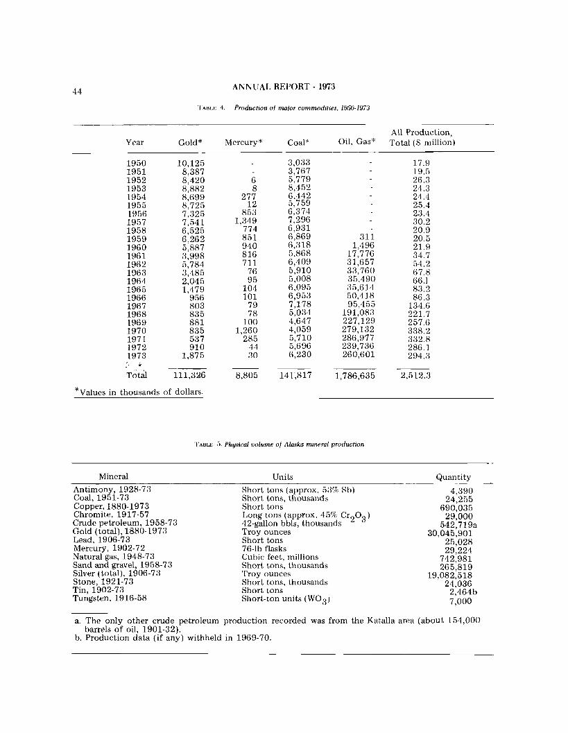
4 4 ANNUAL REPORT - 1973
. I ' A ~ L E 4. Production of major commodities, 1950-1973
Year Gold" Mercury * All Production,
Oil, Gas* Total ($ million)
17.9 19.5 26.3 24.3 24.4 25.4
* Values in thousands of dollars.
I'ABLE 5. Phqsical volume of Alaska mineral production
Mineral Units Quantity
Antimony, 1928-73 Coal. 1951-73 copper, 1880-1973 Chromite, 1917-57 Crude petroleum. 1958-73 Gold (total), 1880-1973 Lead, 1906-73 Mercury, 1902-72 Natural gas, 1948-73 Sand and gravel, 1958-73 Silver (total), 1906-73 Stone, 1921-73 Tin, 1902-73 Tungsten, 1916-58
Short tons (approx. 53% Sb) Short tons, thousands Short tons Long tons (approx. 45% Cr203) 42-gallon bbls, thousands Troy ounces Short tons 76-lb flasks Cubic feet, millions Short tons, thousands Troy ounces Short tons, thousands Short tons Short-ton units ( W 0 3 )
a. The only other crude petroleum production recorded was from the Katalla area (about 154,000 barrels of oil, 1901-32).
b. Production data (if any) withheld in 1969-70.

CONSERVATION AND REGULATIONS 4 5
Hogatza River. Ernest Wolff and Associates re- floated the dredge on Coal Creek and were in production by the end of the season. Other producing areas were Marvel Creek, Flat, Liven- good (p. 9). Manley Hot Springs, the Seward Peninsula, Fortymile, Boundary, Wiseman, and Ruby. The primary operators on the Seward Peninsula continued to be the Tweet Brothers, who operate a dredge on the Kougarok River. There was no known lode production during the year; however, Ptarmigan Exploration was actively reworking the old tailings of the Nabesna mine, and a small mine in the Willow area was opened.
, , r t PLATINUM \ -
The Goodnews Bay Mining Company continued to operate its floating dredge and a sluicebox on the Salmon River. The volume of mineral produced was about the same as 1972. Minor amounts of platinum were produced by a few small gold placer operations.
MAJOR BASE METALS
One mine in the McCarthy area reportedly pro- duced 400 tons of copper ore. The ore was chalcocite, and about 200 tons of copper will be productxd. As of the first of the year, only one truckload of ore had been removed from the mine to the highway for shipment. 'I'he ore was pro- duced by selectively sorting chalcocite containing 50%-60% copper while driving 330 feet of drift. Additional ore was recovered by hand-sorting from the old exploration drift dumps.
The ASARCO Smeltcr in Tacoma was unable to take Alaskan ores because of environmental pol- lution controls.
One operator in the southc'rn part of Fairbanks quadrangle shipped approximately 14 tons of silver-bearing lead ore, mined in 1972, to the smelter at Helena, Montana. A small amount of production continued in this area, but n o further plans for shipping ore were made. A n operator in the Kantishna district produced several hundred tons of ore during the summer months while sinking a preliminary production shaft. The ore was milled at a concentrator about 1 mile from the mine. The total lead production for the year is estimated a t 10 tons.
TIN
Production continued from a tin placer opera- tion near Tin City. Also, minor amounts of tin were recovered from gold placer operations near Manley Hot Springs.
MINOR BASE METALS
Although the price of mercury increased from $150 t o nearly $300 per flask in 1973, there was very little activity. Robert Lyman continued min- ing and operating a small concentrator of cinnabar ore a t White Mountain, southeast of McGrath. There was some exploration near Sleetmute, but no known production.
ANTIMONY
With an increase in the price of antimony dur- ing the summer, a renewed interest was shown in the mining of this metal. Producing antimony for shipment were at least three operators from the Kantishna area and two from the Fairbanks area. There was continued nctivity of mining of anti- mony in the Fortymile district, but n o shipments were known.
INDUSTRIAL MINERALS - BARITE
Alaska Barite, a subsidiary of Inlet Oil, con- tinued operating the underwater open-pit mine near Castle Island, about 1 2 miles southeast of Petersburg. A feasibility study was made on moving the mill from Kenai to Castle Island and restricting the operation to providing a finished ground-barite product for drilling mud. This would maintain about the same dollar value for the output from the mine, but would considerably reduce the barite tonnage.
COAL
There was only one coal producer In Alaska during 1973---the Usibelli mine near Healy. The production and consumption of coal continued a t about the same level as in 1972, with the Healy field supplying most of the fuel for generation of electrical power in the Fairbanks area. Although the major mining effort was moved from Healy Creek to Lignite Creek, the same tipple and ship- wing facilities continued t o be used.

Making camp by track vehicle, Valdez Creek Valley, central Alanka.
PROGRAMS PLANNED FOR 1974
BROOKS RANGE PROJECT
The data from the field investigations are cur- rently being analyzed. This includes petrographic studies, assays of mineralized rock samples, and submittal of samples for age-dating. The results of the geochemical sampling program are being pre- pared for release in open-file format. Geologic maps are also being prepared for release; these maps, now scaled 1 inch to 1 mile, will eventually be compiled a t a scale of 1 inch to 4 miles.
DGGS plans to continue participation in geo- logic investigations in the Brooks Range with the USGS. The data from the 1973 field season is cur- rently being studied by geologists from both the DGGS and the USGS, and publication of results will be handled through the facilities of both surveys.
STATEWIDE ORE DEPOSITS STUDY
Future work by T.E. Smith will emphasize statewide aspects of metallization. Subject to bud- get approval, Smith plans a comprehensive program t o investigate the temporal distribution of Alaska ore deposits. This work, to be carried out in col- laboration with D.L. Turner, will initially apply potassium-argon and fission-track methods to the dating of alteration assemblages from hydrothermal deposits.
FURTHER ZEOLITE STUDIES
A few samples of tuff collected by Hawkins dur- ing 1973 from the Tertiary volcanics at the head of Caribou Creek, upper Matanuska Valley, were not zeolitized. However, vesicular volcanics associated with the tuffs were zeolitized, suggesting that there may be local areas of zeolitization in the extensive tuff deposits of the area. Prospecting for zeolites in the silicic volcanics a t the head of Caribou Creek and in the volcanics of the Talkeetna formation in the area between the upper parts of the Oshetna and Little Oshetna Rivers is planned for the sum- mer of 1974.
In addition, several proposed studies t o evaluate
the gas-sorptive properties and ion-exchange prop- erties of the zeolites of the Sheep Mountain and Horn Mountains area have been prepared by Hawkins and submitted to various funding agen- cies.
GEOPHYSICS
AEROMAGNETIC
The aeromagnetic program in 1974 is scheduled to be flown in the Brooks Range mineral belt, The program will be used to assist in the planning and selection of State lands, to aid in determining the mineral potential of the area, and to provide basic data to be used by the joint USGS-DGGS Brooks Range field project team in 1974.
The DGGS will also continue the magnetic sus- ceptibility studies began in 1973. This is a long- range program to establish a magnetic-susceptibil- ity data base throughout the state.
SEISMIC
DGGS personnel are periodically requested to regulate and monitor core-hole drilling in offshore areas of Alaska. Seismic records of the locations, usually provided by the contractor, are interpreted to ensure that the proposed core holes will not be drilled in potential oil or gas zones.
RADIOMETRIC
As soon as the necessary equipment can be ob- tained, the DGGS intends t o initiate a long-range program to obtain radiometric samples throughout the state. The program will be a part of various ex- isting field projects in 1974.
FIELD PROGRAMS
TALKEETNA MOUNTAINS
A field mapping project with helicopter support

4 8 ANNUAL REPORT - 1973
is planned for the summer of 1974 in the Talkeetna program on the Alaska Peninsula. Efforts will be Mountains Emphasis will be on completing the directed toward evaluating the oil and gas potential geology of the Anchorage D-5 quadrangle. A part of Cenozoic and Mesozoic rocks. Reconnaissance of this program is a detailed examination of min- geochemical sampling will be carried on simultane- eralized alteration zones in the east portion of the ously in the areas of intrusive and volcanic activity quadrangle. in search for mineralized zones.
THEODORE RIVER AREA COLD BAY AREA
DGGS proposes to examine Kenai sediments Approximately 10 days will be spent sampling, northeast of the Beluga River. This program, in- mapping, and measuring unmapped Tertiary rocks volving about 10 days of field work, will be in this area. concentrated along the Theodore River on the west side of Cook Inlet. The primary objective will be to examine the Lower Kenai sediments and relate PORT MOLLER AREA these sediments to those along the Beluga River. Support will include a contract helicopter for ac- Thick early Tertiary sediments will be measured cess and fixed-wing aircraft for the return trip. and sampled for oil and gas potential. (This is most
of the Tertiary section not examined in 1973.)
YUKON-KANDIK AREA CHIGNIK AREA
A field program in the Yukon Flats--Kandik Basin area has been proposed for the summer of Reconnaissance geochemical sampling will be 1974. The program is in conjunction with a geo- continued in the Black Lake and Warner Bay areas. logic study to determine land-use priorities of the area. The program will involve investigation of Ter- tiary sedimentation and age relationships, some SHUMAGIN ISLANDS geologic mapping, and a reconnaissance radiometric survey. Reconnaissance geochemical sampling of a part
of the Shumagin Islands will be initiated if weather conditions and time permit.
BRISTOL BAY BASIN
The DGGS will continue the resource evaluation


PUBLICATIONS
DGGS publications available to the public are the following: Annual and Biennial Reports, 1912-1972 Information Circulars Miscellaneom Papers Geologic Reports Geochemical Reports Open-IGle Reports Special Reports Laboratory Notes Bibliographies Papers Given at National Conferences
. DGGS Contributions to National Publications
There is a $1.00 charge for the Geologic, Geochemical, and Special Reports. The Bibliographies are also $1.00, unless otherwise noted. The Open File reports are available solely through commercial printers, and vary in price. All other publications (except those designated Out of Print) are available free of charge.
ANNUAL AND BIENNIAL REPORTS, 1912.1972
Report of the Mine Inspector for the Territory of Alaska to the Secretary of the Interior, 1912
' Report of the Mine Inspector for the Territory of Alaska to the Secretary of the Interior, 1913
Report of the Mine Inspector for the Territory of Alaska to the Secretary of the Interior, 1914
' Report of the Territorial Mine Inspector to the Governor of Alaska, 1915
' Report of the Territorial Mine Inspector to the Governor of Alaska, 1916
' Report of the Territorial Mine Inspector to the Governor of Alaska, 1917
' Biennial Report of the Territorial Labor Commissioner to the Governor of Alaska, 1919-1920
" Annual Report of the Territorial Mine Inspector to the Governor of Alaska, 1920
O Annual Report of the Territorial Mine Inspector to the Governor of Alaska, 1921
' Biennial Report of the Territorial Labor Commissioner to the Governor of Alaska, 1921-1922
' Annual Report of the Mine Inspector to the Governor of Alaska, 1922
Annual Report of the Mine Inspector to the Governor of Alaska, 1923
Out of print. On file at DGGS Fairbanks office (p. 2) and at certain public and oni$,ersity libraries

ANNUAL REPORT - 1973
" Report upon Industrial Accidents Compensation and Insurance in Alaska, 1924
* Report of the Territorial Mine Inspector, 1925-1928
Report of Cooperation between the Territory of Alaska and the United States in Making Mining Investigations and in the Inspection of Mines, 1929
* Report of Cooperation between the Territory of Alaska and the United States in Making Mining Investigations and in the Inspection of Mines, 1931
* Report of the Commissioner of Mines to the Governor, 1936
* Report of the Commissioner of Mines to the Governor, 1938
* Report of the Commissioner of Miness to the Governor, 1940
* Report of the Commissioner of Mines to the Governor, 1944
" Report of the Commissioner of Mines, 1946
" Report of the Commissioner of Mines, 1948
* Report of the Commissioner of Mines, 1950
* Report of the Commissioner of Mines, 1952
* Report of the Commissioner of Mines, 1954
* Report of the Commissioner of Mines, 1956
" Report of the Commissioner of Mines, 1958
" Report of the Commissioner of Mines, 1960
Report of the Division of Mines and Minerals, 1961
* Report of the Division of Mines and Minerals, 1962
Report of the Division of Mines and Minerals, 1963
Report of the Division of Mines and Minerals, 1964
Report of the Division of Mines and Minerals, 1965
* Report of the Division of Mines and Minerals, 1966
* Report of the Division of Mines and Minerals, 1967
Report of the Division of Mines and Minerals, 1968
Report of the Division of Mines and Minerals, 1969
" Annual Report of the Division of Geological Survey, 1970
* Annual Report of the Division of Geological Survey, 1971
Annual Report of the Division of Geological and Geophysical Surveys, 1972

INFORMATION CIRCULARS
No. 1. Proper Claim Staking in Alaska, Revised November 12, 1970
No. 2. Mineral Rights of Aliens in the State of Alaska, Revised March 1 , 1968
No. 3 Hand Placer Mining Methods, Revised March 5, 1988
No. 4 Uranium Prospecting in Alaska, Revised March 7, 1968
No. 5 General Alaskan Mineral Information, Revised July 8. 1971
No. 6 Alaska Prospecting Information, Revised April 8, 1971
No. 7. Alaskan Companies and Prospectors.lg73, November 27, 1972
No. 8. Consultants Available for Work in Alaska, Revised November 18, 1972
No. 9. Alaska Rockhound Informafion, Revised March 23, 1972
No. 10. Skin Diving for Gold in Alaska, Revised April 2, 1968
No. 11. List o f Reports Issued b y the Division o f Geological and Geophysical Surveys, Revised November 16, 1973
No. 12. Services of the Division of Geological Survey, Revised July 8, 1971
No. 13. Dangers in Old Mine Openings, Revised November 6, 1972
No. 14. Mining Laws Applicable in Alaska, Revised February 25, 1971
No. 15. A Prospectors Guide to the Sale and Lease o f Mineral Properties, Revised June 12, 1969
No. 16. Alaska Map Information, Revised September 29, 1972
No. 17. Companies Interested in Alaskan Mining Possibilities, Revised March 1, 1973
No. 18. Amateur Gold Prospecting in Alaska, November 15, 1973
MISCELLANEOUS PAPERS
No. 1 The Great Alaska Earthquake, Marcll27, 1964: May 19, 1904.
No. 2 Preliminary Results of Stream Sediment Sampling, Upper Maclaren liioer Area, South-Central A h k a , b y Thomas E. Smith, Thomas C. Trible, and Donald R . Stein
- - The Mineral Industry of the Kenai-Cook Inlet-Susitna Region, 1962, by William H. Race
- - Some High-Calcium Limestone Deposits in Southeastern Aluska, Pamphlet 6, March 1948
GEOLOGIC REPORTS
No. 1 Preliminary Report on Geologic Mapping in the Coast Range Mineral Belt, by Gordon Herreid. This report was formerly included in Annual Report of the Division of Mines and Minerals for the year 1902. Price $1.00
No. 2 Bedrock Geology of the Rainbow Mountain Area, Alaska Range, Alaska; an M.S. thesis prepared b y Lnrry G. Hanson of the University of Alaska in cooperation toitll the Division of Minesand Minerals, November 1963. Out o f print

ANNUAL REPORT - 1973
No. 3 Geology of the Portage Creek-Susitna River Area, by Donald Richter, 1963 (2 large sheets). Out of print.
NO. 4 Geology and Mineral Deposits of the Denali-Maclaren River Area, Aluska, by M.A. Kaufman, blay 1964. (14 p. and map). Price $1.00 Out of print
NO. 5 Geology of the Niblack Anchorage Area, Southeastern Alaska, by Gordon Herreid, May 1964. Out of print
No. 6 Geology and Mineral Deposits of the Ahtell Creek Area, Slana District, Southcentral Alaska, by Donald H. Richter, May 1964. (17 p. and map). Out of print
No. 7 Geology of the Dry Pass Area, Southeastern Alaska, by Gordon Herreid and Iv1.A. Kaufman, June 1964. (16 p.). Price $1.00
No. 8 Geology of the Paint River Area,llliamna Quadrangle, Alaska, by D.H. Richter and Gordon Herreid, January 1965. (18 p. and map). Price $1.00
No. 9 A Geologic and Geochemical Traverse Along the Nellie Juan River, Kenai Peninsula, Alaska, by Gordon Herreid, August 1965. (2 p. and map). Out of print
No. 10 Geology of the Bluff Area, Solomon Quadrangle, Seward Peninsula, Alaska, by Gordon Herreid, June 1965. (21 p. and map). Out of print
No. 11 Geology of the Omilak-Otter Creek Area, Bendeleben Quadrangle, Seward Peninsula, Alaska, by Gordon Herreid, June 1M5. (12 p. and map). Out of print
NO. 12 Geology of the Bear Creek Area, SewardPeninsula, Candle Quadrangle, Alaska, by GordonHerreid, May 1965 (15 p. and maps). Out of print
No. 13 Geology and Geochemical Investigations near Paxson, Northern Copper River Basin, Alaska, by A.W. Rose and R.H. Saunders, June 1965. (35 p.) Price $1.00
No. 14 Geology and Mineral Deposits of the Rainy Creek Area, Mt. Hayes Quadrangle, Alaska, by A.\.V. Rose, May 1965. (51 p. and map). Out of print
No. 15 Geology and mineralization of the Midas A4ine and Strlphide Gulch Areas near Valdez, Alaska, by A.M1. Rose, March 1965. (21 p., map, and tables). Price $1.00
No. 16 Geology and Mineral Deposits of Central Knight Island, Prince William Sound, Alaska, by D.H. Richter, July 1965. (35 p. and maps). Out of print
No. 17 Geology and Geochemistry of the Hollis and Twelvemile Creek Areas, Prince o f Wales Island, Southeastern Alaska, by Gordon Herreid and A.W. Rose, April 1966. (32p., with numerous maps and figures). Price $1.00
NO. 18 Geology o f Chromite-Bearing Ultramafic Rocks near Eklutna, Anchorage Quadrangle, A h k a , by A.W. Rose, February 1966. (20 p., maps, and tables). Price $1.00
No. 19 Geology of Port of the Amphitheatre Mountains, Mt. Hayes Quadrangle, Alaska, by A.\V. Rose, February 1966. (12 p., with maps and tables). Price $1.00
No. 20 Geological and Geochemical lnuestigations in the Eureka Creek and Rainy Creek Areas, hit. Hayes Quadrangle, Alaska, by A.W. Rose, June 1966. (36 p., maps and tables).
No. 21 Geology of the Slana District, Southcentral Alaska, by D.H. Richter, July 1966. (51 p., andmaps). Out of print

PUBLICATIONS 5 3
No. 22 Geology and Geochemistry of the Nixon Fork Area, Medfra Quadrangle, Alaska, by Gordon Herreid, July 1966. (29 p., map, and tables). Price $1.00
No. 23 The Geology and Geochemistry of the Inmachuk River Map Area, Seiourd Peninsula, Alaska, by Gordon Herreid, November 1966. (2.5 p., map, and tables). Price $1.00
No. 24 Preliminary Geology and Geochemistry of the Sinuk River Area, Seward Peninsula, Alaska, by Gordon Herreid, May 1966. (19 p., map, and tables). Price $1.00
No. 25 Geological and Geochemical Investigation in the Metal Creek Area, Chugach Mountains, Alaska, by D.H. Richter, May 1967. (17 p., map, and tables). Price $1.00
No. 26 Geological and Geochemical Investigations Southwest o f Farewell,Alaska, by Cordon Herreid, July 1 W . (15 p., maps, and tables). Price $1.00
No. 27 Geology and Mineral Deposits of the Dolomi Area, Prince of Wales Island, Alaska, b y Gordon Herreid, June 1967. (2.5 p., maps, and tables). Price $1.00
No. 28 Geology o f the Upper Chistochina River Area, Mt. Hayes Quadrangle, Alaska, by A.W. Rose, February 1967. (39 p., maps, and tables). Price $1.00
No. 29 Progress Report on the Geology arid Geochemistry of the Sinuk Area, Sewurd Peninsula, Alaska, by Gorclon Herreid, July 1968. (13 p., maps, and tables). Price $1.00
No. 30 Geology of the Upper Slana-Mentasta Pass Area, Soutllcentral Alaska, by D.H. Richter, May 1967 (25 p., maps, and tables). Price $1.00
No. 31 Geology and Stream Sediment Geochemistry of Anton Larsen Bat/ and Vicinity, Kodiak Island, Alaska, by A.M'. Rose and D.H. Richter, April 1967. (10 p., and map). Price $1.00
No. 32 Geology o f an area on the Upper Talkeetna River, Talkeetna Mountains Quadrangle, Alaska by A,!\'. Rose, February 1967. (17 p. and map). Price $1.00
No. 33 Geologic and Geochemical Study, Solomon C-5 Quadrangle, Seward Peninsula, Alaska, by R.H. Asher, April 1969. (64 p., map, and tables). Price $1.00
No. 34 Geology and Geochemistry, Diana Lakes Area, Western Talkeetna hlountains, Alaska, by R.E. Anderson, Jrine 1969. (27 p., map, and tables). Price $1.00
No. 35 Geology and Geochemistry, Sithylemenkat Lake Area, Bettles Quadrangle, Alaska, by Gordon Herreicl, June 1969. (22 p., map, and tables). Price $1.00
No. 36 Geology and Geochemistry of the Sinrrk Area, Seward Peninsula, Alaska, by Gordon Heueid. (78p., map, and tables). Price $1.00
No. 37 Geology and Geochemistry in the Southeastern Part of the Cosmos Hills, Shungnak 0 - 2 Quadrangle, Alaska, by Crawford E. Fritts, June 1969. (35 p., and maps). Price $1.00
No. 38 Uranitrm in Alaslca, by G.R. Eakins, May 1969. (49 p. , and maps). Price $1.00
NO, 39 Geology and Geochemistry of the Cosmos Hills,Ambler River h+ Shtrngnuk Quadrangles, Alaska, b y Crawford E . Fritts, September 1970. (63 p., maps and tables). Price $1.00
No. 40 Geology of the Spirit Mountain Nickel-Copper Prospect and Surrourtding Area, by Gordon Herreid, August 1970. (19 p. ancl maps). Price $1.00

54 ANNUAL REPORT - 1973
No. 41 An Experiment in Geobotanical Prospecting For UraniutqBokan MountainArea,SoutheasternAlaska, by G. R. Eakins, August 1970. (51 p., maps and illustrat~ons). Price $1.00
No. 42 Geology and Geochemistry of the Chandalar Area Brooks Range, Alaska, by E. R. Chipp, September 1970. (39 p., maps and illustrations). Price $1.00
GEOCHEMICAL REPORTS
No. 1. Geochemical lnuestigations of Selected Areasin Southeastern Alaska, 1964, by C.F. Herbert and W.H. Race, November 1964. (27 p., numerous tables and maps). Out of print. Has been mostly included with the 1965 work in Geochemical Report No. 6 and partly in Geologic Report No. 17.
No. 2. Geochemical Investigation of the Slana District, Southcentral Alaska, 1963 and 1964, by D.H. Richter, March 1965. (14 p. and map). Out of print
No. 3. A Geochemical Investigation in the Richardson Area, Big Delta Quadrangle, Alaska, by H.H. Saunders, April 1965. (11 p. and maps). Out of print
No. 4. Geochemical Investigation of Selected Areas in Southcentral Alaska, 1964, by IZI.\Y. Jasper, May 1965. (31 p., map, and tables). Price $1.00
NO. 5. A Geochemical Investigation between Chatanika and Circle Hot Springs, Alaska, by W.M. Burand, May 1965. (11 p. and 2 plates). Price $1.00
NO. 6. Geochemical lnvestigations of Selected Areas in Southeastern Alaska, 1964 and1965, by C.F. Herbert and W.H. Race, December 1965. (66 p., maps, and tables). Price $1.00
No. 7. Geochemical Investigations Along Highway and Secondary Roads in Southcentral Alaska, 1965, by M.W. Jasper, July 1966. (8 p., various tables, and illustrations). Price $1.00
No. 8. Geochemical and Geological lnvestigations of Admiralty Island, Alaska, by 1V.H. Hace and A.1V. Rose, March 1967. (43 p., maps, and tables). Price $1.00
No. 9. A Geochemical Investigation Along the Taylor Highway, East-Central Alaska, by R.H. Saunders, February 1966. (17 p., table, and Appendix). Price $1.00
No. 10 A Geochemical lnvestigation of the Nenana Highway Area, Central Alaska, by W.M. Burand, April 1 W . (13 p., maps, and figures). Price $1.00
No. 11 A Geochemical Investigation of Stream Sediments in the Elliott Highway Area, Alaska, by W.M. Burand, July 1966. (16 p. and numerous figures). Price $1.00
No. 12 A Geochemical Investigation of Minook Creek, Rampart District, Alaska, by W.M. Burand and R.H. Saunders, April 1966. (15 p. and figures). Price $1.00
No. 13 Geochemical Investigations of Selected Areas in the Yukon-Tanana Region of Alaska, 1965 and 1966, by W.M. Burand, May 1968. (51 p. and tables). Price $1.00
No. 14 Geochemical Investigations Willow Creek Southerly t o Kenai Lake Region, Southcentral Alaska, by M.W. Jasper, June 1967. (47 p. and tables). Price $1.00
No. 15 Geochemical lnvestigations Along the Valdez to Chitina Highway in South-central Alaska, 1966, by M.W. Jasper, April 1967. (19 p. and numerous figures). Price $1.00
No. 16 A Geochemical Investigation of a Portion of the Fortymile District, Alaska, by W.H. Smith, June 1968. (17 p., map, and tables). Price $1.00

PUBLICATIONS 55
No. 14. A Geochemical lnvestigation of the W o o d River-Tikchik Lakes Area, Southwestern Alaska, by G.R. Eakins, May 1968. (31 p. , map, and tables). Price $1.00
Sup. A Geochemical lnvestigation of the Wood River-Tikchik Lakes Area, Southwesiern Alaska, by G.R. No. 17 Eakins, March 1969. (3 I)., table and figures). No charge
No. 18. Geology and Geocllemistry of Part of the lron Creek Area, Solomon D-6 Quadrangle, Seward Peninsula, Alaska, by R.H. Asher, April 1969. (18 p, and Appendix). Price $1.00
NO. 19. Preliminary Geochemistry and Geology, Little Falls Creek Area, Talkeetr~a Mountains Quadrangle, Alaska, by R.E. Anderson, March 1969. (16 p. , map, and tables). Price $1.00
No. 20 Geology and Geochemistry at Kontrashibtrna Lake, Lake Clark Region Soutl~western Alaska, by G.R. Eakins, August 1970. (34 p., maps and illustrations). Price $1.00
No. 21 Geochemical Survey and Geological Heconnaissat~ce of the U7/lite River Area, Sotitl~ C:entralAlnska, by Jeff Knaebel, October 1870. (60 p. , maps and illustrations). Price $1.00
No. 22. Geology and Geochemistry of the Belt Creek-Libby River Area Seward Penit~sula Alaska, by H.H Asher, July 1970. (42 p., maps ant1 tables). Price $1.00
No. 2.3 Geochemistry artd Geology, Boundary Area, Fortymile District Eagle A-1 Quadrangle, Alaska, by H.R. Asher, September 1970. (32 p., maps and tables). Price $1.00
A Geochemical lrtvestigatiorl in theEagle A-1 Quadrangle, Fortymile District, Alaska, by R.R. Asher, May 1970. (4 p., map and tables). No charge
No. 24 Analyses of Rock and Stream-Sediment Samples, h'etta Inlet Area, Prince of Wales Island, Craig Quadrangle, Alaska, by Gordon Herreid, November 1971. (map and tables). Price $1.00
No. 5. Analyses o f Rock and Stream Sediment Samples, Wild Lake Area, Wiseman Qtradrangle, Arctic Alnska, by E.R. Chipp, 1972. (map and table). Price $1.00
No. 26. Analyses o f Hock and Stream Sediment Samples, Mt. Hayes A-6 Quadrangle, South-Central Alaska, by Thomas E . Smith, Thonias C. Trible, and Donald H. Stein (map and table). Price $1.00
NO. 27. Analyses o f Stream Sediment Samples, Craig A-2 Quadrangle and Vicinity, Prince of Wales Island, Southeastern Alaska, by Gordon Herreid and Thomas C. Trible (map and table). Price $1.00
SPECIAL REPORTS
No. 1. History of Mines and Prospects, Ketchikan District, Prior to 1952, by John Bufvers, February 1967. (32 p.). Price $1.00
No. 2. Mineral Occurrences in the Yukon-Tanana Region, Alaska, by R.H. Saunders, April 1867. (58p., map, and figures). Out of print
No. 3. A Petrified Forest on Unga Island, Alaska, by G.R. Eakins, July 1970. (19 11. and map). Price $1.00
No. 4. Mineralization Near Stepovak Bay, Alaska Peninsula, Alaska, by G.R. Eakins, July 1970. (12 p., map, and tables). Price $1.00
No. 5. Preliminary Report on Stratigraphy of Kenai Group, Upper Cook Inlet, Alaska, by D.C. I-Iartman, G.H. Pessel, D.L. McGee, July 1972. (3 p., 11 plates). Out of print
No. 6. Sedimentary Zeolite Deposits of the Upper Matanuska Valley, Alaska, by D.B. Hawkins, Nov. 1973. (17 p., map). Price $1.00

PUBLICATIONS
LABORATORY REPORTS
N ~ , 1 A Rapid Radiometric Analysis For Eqlrivalent Uranium, by P.L. Anderson and M. Mitchell, Jr., May 1969. (7 p. and tables)
No. 2 Analysis of Copper, Lead, and Zinc b y Atomic Absorption Spectrophotometry, by P.L. Anderson and N. Cho, May 1969. (13 p. and tables)
No. 3 Geochemical Analytical Procedure for Copper, Lead, and Zinc b y Atomic Absorption Spectroscopy, by P.L. Anderson, April 1969. (9 p. and tables).
LABORATORY NOTES
No. 1 Precision and Accuracy o f the Gold-Silver Analysis b y Atomic Absorption on a Quartz-Type Rock.
No. 2 Laboratory Test of Zinc in Water and Ice.
No. 3 AAS Analyses of Gold and Silver in High Antimony Samples
No. 4 Digestion of Heavy Sulfide Ores for AAS Analyses.
No. 5 Suggested Reporting Procedtrres for Atomic Absorption Silver and Gold Analyses
No. 6 lmproved Mercury Analyses b y XRS.
No. 7 Molybdenum Anulyses b y Atomic Spectroscopy.
No. 8 An Investigation of the 28331 AAS Lead Line.
No. 9 Interference b y Calcium, biagnesiurn, and Iron on Lead, Zinc, and Silver b y AAS Analyses
No. 10 Semi-Quantitative Uranium Analysis b y X-ray Spectography.
NO. 11 Potential Geochemical Sample Contamination from Cloth Sample Bags.
No. 12 Comparison Analyses.
No. 13 Some Experiments in the Geochemistry o f Copper and Zinc.
No. 14 Dithizone Field Test -Some Suggestions.
No. 15 A Geochemical Orientation Study for Lead and Zinc in the Fairbanks, Alaska Area.
No. 16 Development of the Spectrographic 30 Element Geochemical Analyses.
No. 17 N e w XRS Procedure.
No. 18 An Investigation into the Use of MlBK and DIBK-Aliquot 336 with Atomic Absorption Spectrophotometry in the Analysis of Gold

A N N U A L REPORT - 1973
BIBLIOGRAPHIES
Bibliography o f Alaskan Geology 1831-1918, compiled by Crawford E. Fritts and Mildred E. Brown, Ilivision of Geological Survey, College, Alaska, 1971. (88 p.). Price $1.00
Uibliograpliy of Alaskan Geology 1919-1949, compiled by Crawford E. Fritts and Mildred E. Brown, Ilivision of Geological Survey, College, Alaska, 19'71. (90 p . ) . Price $1.00
Bibliography of Alaskan Geology 1950-1959, compiled by Crawford E. Fritts and Mildred E. Brown, Division of Geological Survey, College, Alaska, 1971. (82 p . ) Price $1.00
13ibliography of Alaskan Geology 1960-1964, compiled by Crawford E. Fritts and Mildred E. Brown, Ilivision of Geological Survey, College, Alaska. 1971. (81 p . ) . Price $1.00
13ibliography of Alaskan Geology 1965-1968, conlpiled by Crawford E. Fritts and Ellen J . Tuell, Ilivision of Geological Survey, College, Alaska, 1972. (112 p . ) . Price $1.00
13ibliography of Alaskan Geology 1969-1971, compiled by Crawford E. Fritts and Ellen J. Tuell, Ijivision of Geological Survey, College, Alaska, 1972. (a p.) . Price $1.00
Geological Literature otl the Cook Inlet Basin &f Vicinity, Alaska, by J.C. &laher and ii'.h.l. Trollman, published by Department of Xatural Hesources in cooperation with the U.S. Geological Survey. (82 p. and figures). Price $1.50
Geological Literature on the Gulf ar~cl Sotttheasteni Coastal Regions o f Alaska, by J.C. Maher and W.&l. Trollman, published by Departnlent of Katural Resources in cooperation uvith the U.S. Geological Survey. (136 p . ) . Price $1.50
Geological Literature on the Alaska Pet~irlsttla and Adjacent Areas, by J . S . Kelly and J.hl Denman, published by the Department of hatural Hesources in cooperation with the U.S. Geological Survey. (64 p. and figures). Price $1.50
PAPERS GIVEN AT NATIONAL CONFERENCES
Tectonics and Ore Deposits in Alaska, Gordon Herreid, March 19, 196.1, Alaskan AIAIE Conference.
A Pos,dble Guide to Metal Deposits of Alaska, Charles F. Herbert, March 20, 1964, Alaskan AIhnfE Conference.
Deposits of the Kttskokwim District, Alaska, C.K. Conwell, 1971 AIME Pacitic Southwest Mineral Industry Conference.
Mineral Exploration in Alaska, G.H. Eakins, Ilecernber 1 and 2, 1972, Northwest blir~ing Assoc. Convention.
DGGS CONTRIBUTIONS TO NATIONAL PUBLICATIONS
Alaska's Neto Mining Lauj for State Lands, James A. Williarns, Mining Engineering Magazine. December, 19f31.
Geology and Ore Deposits o f Alaska, Gordon Herreid. Mining Engineering Magazine. Ilecernber, 1961.

PUBLICATIONS
Mercury Mining Revival in Alaska Despite Poor Access and Climate, C .N . Conwell. World Mining Magazine, July, 1971.
Age o f Sedimentation, Plutonism and Regional Metamorphism in the Clearwater Mountains Region, T .E. Smith and M.A. Lanphere. Isochron/West, No. 2, August, 1971.
Gold Resource Potential of the Denali Bench Gravels, Valdez Creek Mining District, Aluska, T .E . Smith. U.S. Geol. Survey Prof. Paper 700-D.
Alaskan Coals, C.N. Conwell. Transactions o f thesociety o f blining Engineers o f AIME, \'ol. 252, No. 3, September, 1972.
Aluskan Coals May Prove a Big Plus in Future Exports Picture, C.N. Conwell. Mining Engineering, October, 1972.
Cenozoic Offset along the Denali Fault, Alaska (abs), R.B. Forbes, D.L. Turner, J .H. Stout, and T.E. S m i t h . EOS ( A m . G e o p y s . U n i o n T r n n s . ) , v . 54 , n o . 4 , p . 495, 1973 .
Geochronology o f the Maclaren Metamorphic Belt, South-Central Alaska: A Progress Report, T .E . Smith and D.L. Turner. lsochron/West, no. 7, 21-25, 1973.
The Denali Fault Offset Problem, in United States Geological Survey Alaska Program, R.B. Forbes, D.L. Turner, J.H. Stout, T .E. Smith, and F. Il'eber, U.S. Geol. Survey Circular 683, p. 46, 1973.
Geochronology of Offset along the Denali Fault System in Alaska (abs.), D.L. Turner, T . E . Smith, and R.B. Forbes. Geol. Soc. Amer. Cordilleran Section Meeting Program, Las Vegas, Nu:\:, March 1974.
Maclaren Metamorphic Belt o f Central Alaska (abs.) T.E. Smith and D.L. Turner. Geol. Soc. Amer. Cordilleran Section Meeting Program, Las Vegas, NV, March, 1974.
Comparative Petrology and Structure of the ~Maclaren, Ruby Range, and Coast Range Belts: implications for Offset along the Denali Fault System (abs.) , R.B. Forbes, T . E . Smith, and D.L. Turner. Geol. Soc. Amer. Cordilleran Section Meeting Program, Las Vegas, N V , March 1974.
Lateral Variations of Clay Minerals in the Deltaic Sediments o f the Colville and Adjacent Rivers, North Arctic Alaska (abs.) , A.S. Naidu and T.C. Mowatt. Am. Assoc. Petroleum Geologists-Soc. Econ. Paleontologists National Meeting Program, Anaheim, C A , 1973.
Aspects of Size Distributions, Mineralogy and Geochemistry of Deltaic and Adjacent Shallow Marine Sediments, North Arctic Alaska, A.S. Naidu and T . C . Mowatt. U.S. Coast Guard Oceanog. Rept., 1973 (in press).
Significance of Clay Mineral and Geochemical Studies o f Arctic Ocean Sediments on Paleoclimate Interpretation, A.S. Naidu, T . C . Mowatt, and D . H . Hood. Twenty-fourth Alaskan Science Conference, Atn. Assoc. Adv. Sci - Am. Meteorol. Soc. Symposium and Proceedings on "Climate of the Arctic," Univ. o f Alaska, 1973 (in press).
Environments and Sediments o f the Colville Delta Complex, A.S. Naidu and T .C . Mowatt, in "Deltas as Models for Subsurface Exploration," edited b y M.L.S. Broussard, Houston Geological Society, Houston, T X , 1973 (in press).
Clay Mineralogy and Geochemistry o f Continental Shelf Sediments of the Beaufort Sea (abs.), A.S. Naidu and T . C . Mowatt. "Beaufort Sea Symposium," Arctic Inst. North America, San Francisco, C A , Jan. 1974 (in press).

ANNUAL REPORT - 1973
PUBLICATIONS IN PRESS
Uranium Investigations in Southeastern Alaska, b y Gilbert R. Eakins. (56 p. , 33 figs., 11 tables).
PUBLICATIONS IN PROGRESS
GEOLOGIC REPOnTS
Geology of the Western Clearwater Mountains, South-Central Alaska, by T.E. Smith.
Geology of the Permian Strata in the Rainbow Mottntain area, Central Alaska, b y G.C. Bond
SPECIAL REPORTS Clay Mineralogy and Petrology of the Coal-Bearing Group near Healy, Alaska, by D.M. l'riplehorn.
O P E N - F I L E REPORTS
Geochemical Artak{sis of Stream-Seciimertt Samples from the Ambler Ricer A-4, A-5, I?-4, 13-5, C-4, and C-5 Q~radrangles, Alaska, by R.E. Garland and G.H. Pessel, table and map sheet, scale 1:&3,360.
Geochemical Artolysis of Stream-Sediment Samples from tlie Arnbler Riuer A-I, A-2, A-$3, B-1, B-2, B- 3 , C-1, C-2, arid C-3 Quadrangles, Alaska, by H.E Garland and G I I Pe~scl , table and map sheet, scale 1:63,360.
BIBLIOGRAPHY
Bibliograpliy of Alaskan Geolog!/, USGS and U.S . Bureatr of hiines Operl File Reports, C.E. Fritts, K.E. Garland, h.1.E. Brown, anti E.J. ?'tiell.