ap human geography - wikispaces.netekeneavy.cmswiki.wikispaces.net/file/view/ap geography test...
TRANSCRIPT

AP Human
Geography
Essential Models
And
Vocabulary
Scrap Book
2008-2009
Mr. Daniel J. Whalen M.A.
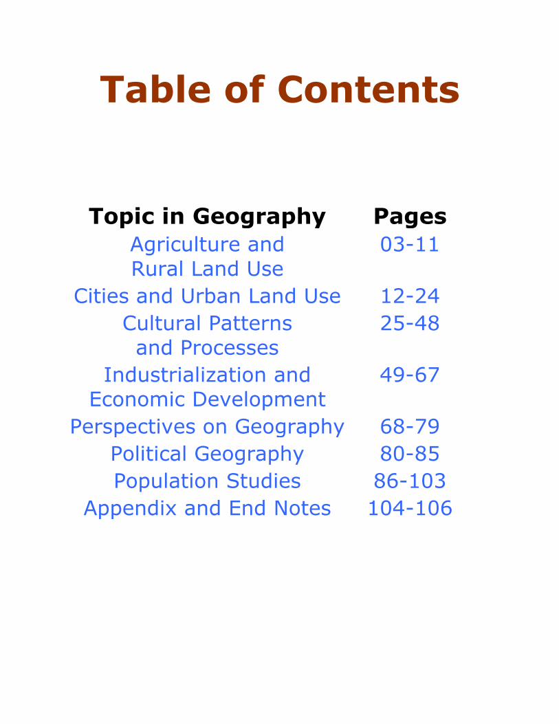
Table of Contents
Topic in Geography Pages
Agriculture and
Rural Land Use
03-11
Cities and Urban Land Use 12-24
Cultural Patterns
and Processes
25-48
Industrialization and
Economic Development
49-67
Perspectives on Geography 68-79
Political Geography 80-85
Population Studies 86-103
Appendix and End Notes 104-106

Perspectives
On
Geography

Environmental Determinism
Visual
Summary:
p.25
Student Notes:

Possibilism
Visual
Summary: p.25
Student Notes:
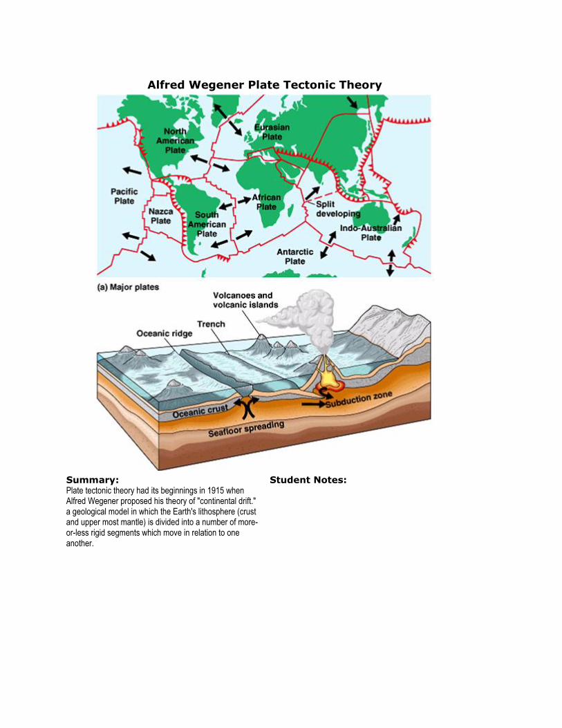
Alfred Wegener Plate Tectonic Theory
Summary: Plate tectonic theory had its beginnings in 1915 when Alfred Wegener proposed his theory of "continental drift." a geological model in which the Earth's lithosphere (crust and upper most mantle) is divided into a number of more-or-less rigid segments which move in relation to one another.
Student Notes:

The Two Step Process of Creating a Projection
Summary:
p.504
Student Notes:

Mercator Projection
Summary:
p.505
Student Notes:

Gnomic Projection
Summary:
P.505
Student Notes:

Goode’s Homolosine Projection
Summary:
p.506
Student Notes:
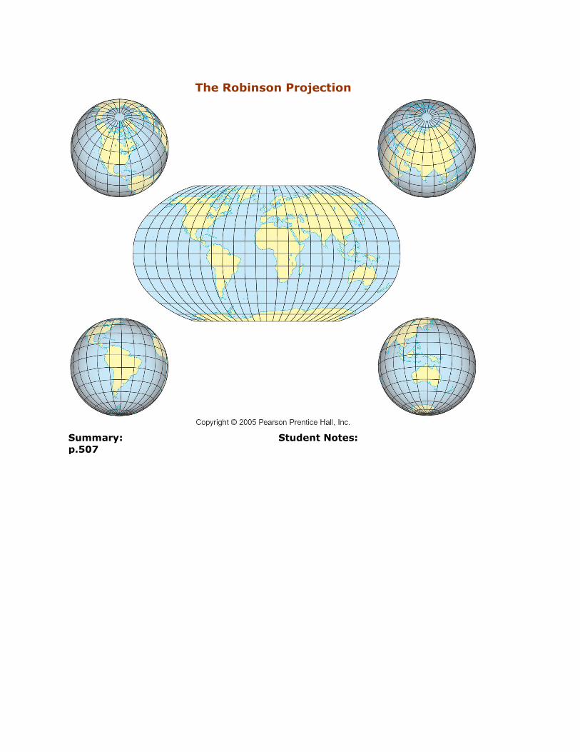
The Robinson Projection
Summary:
p.507
Student Notes:

Geographic Information System Layers
Summary:
p.507
p.12
Student Notes:

Unit One: Nature of and Perspectives on Geography Aristotle Aristotle's proof (c.350 BC) of the earth's sphericity and his introduction of the general
principle of dividing the globe into zones
Climate The composite or generally prevailing weather conditions of a region, as temperature, air pressure, humidity, precipitation, sunshine, cloudiness, and winds, throughout the year, averaged over a series of years.
Concentration The way a feature is spread over an area.
Culture The behaviors and beliefs characteristic of a particular social, ethnic, or age group
Cultural ecology / and or Possibilism
Though the physical environment may limit certain human activates, humans can adapt to their environment or adapt the environment to their activities.
Density The frequency with which a feature occurs in an area.
Density (Agricultural) The ratio if the number of farmers to the total amount of land suitable for agriculture
Density (Arithmetic) a measurement of population per unit area or unit volume.
Density (Housing) A measurement of housing units in a given area
Density (Physiological) The ratio of arable land to a country’s population.
Diffusion The spread of a feature or human characteristic through space.
Diffusion (Expansion) Hierarchical Diffusion: The spread of ideas from persons or nodes of authority or power to other persons places; Ex laws against the use of cell phones in cars Contagious Diffusion: the rapid widespread diffusion of a characteristic throughout a population like people doing a wave at a stadium or the spread of influenza. Stimulus Diffusion: The spread of an underlying principal such as the transmission of news from news papers, to radio, to television, to the internet.
Diffusion (Relocation) The spread of an idea through the physical movement of people from one place to another, such as the spread of Amish communities through the United States.
Distortion A change in the shape of an image resulting from imperfections of scale.
Distribution The spatial arrangement of something over earth’s surface.
Environmental determinism
view that human activities are governed by the environment, primarily the physical environment.
Environmental modification
Human beings ability to adapt their environment for their own purposes.
Eratosthenes (c.275–194 BC) established mathematical geography as a science
GIS A geographic information system (GIS) integrates hardware, software, and data for capturing, managing, analyzing, and displaying all forms of geographically referenced information
Global scale A phenomena which is global in its effect.
Globalization The process of transformation of local or regional cultural phenomena into global ones and in general the increasing interdependence of the world economies.
GPS A system of satellites, computers, and receivers that is able to determine the latitude and longitude of a receiver on Earth by calculating the time difference for signals from different satellites to reach the receiver.
Greenwich Mean Time the local time at the 0 meridian passing through Greenwich, England;
Immigration To enter and settle in a country or region to which one is not native.
International Date Line a theoretical line following approximately the 180th meridian, the regions to the east of which are counted as being one day earlier in their calendar dates than the regions to the west
Landforms One of the features that make up the earth's surface, such as a plain, mountain, or valley.
Landscape (Cultural) Geographical areas or properties uniquely representing the combined work of nature and of man
Landscape (Natural) Geographical areas or properties unaffected by human activity.
Latitude Regions The differences between them relate to climate, and the behavior of the sun. They are as follows: The North Frigid Zone, north of the Arctic Circle The North Temperate Zone, between the Arctic Circle and the Tropic of Cancer The Torrid Zone, between the Tropics of Cancer and Capricorn

The South Temperate Zone, between the Tropic of Capricorn and the Antarctic Circle The South Frigid Zone, south of the Antarctic Circle
Location (Absolute) Is the exact spot where something is on the earth represented by longitude and latitude or a street address.
Location (Relative) Is the place that something is in comparison to something else.
Longitude The angular distance from prime meridian: the angular distance east or west of the prime meridian that stretches from the North Pole to the South Pole and passes through Greenwich, England. Longitude is measured in degrees, minutes, and seconds.
Map Scale measurement of distances on the map and conversion to real-world distances
Meridian An imaginary great circle on the earth's surface passing through the North and South geographic poles. All points on the same meridian have the same longitude.
Parallel An imaginary east-west line circling a globe
Pattern The geometric arrangement of objects which could be regular or irregular.
Place a space, area, or spot, set apart or used for a particular purpose
Prime Meridian The zero meridian (0°), used as a reference line from which longitude east and west is measured. It passes through Greenwich, England
Projection a projection of the globe onto a flat map using a grid of lines of latitude and longitude
Ptolemy Ptolemy applied its principles in the first half of the second century AD
Region (formal/ uniform) A Region marked by relative uniformity of characteristics; congressional districts are uniform regions.
Region (functional/nodal) A region defined by a social or economic function that occurs between the node or focal point and the surrounding areas.
Region (perceptual/vernacular)
It is an area that exists in the minds of a society, for example the American “South”
Remote Sensing the science of gathering data on an object or area from a considerable distance, as with radar or infrared photography, to observe the earth or a heavenly body
Resources Factors of production occurring in nature; Minerals and fossil fuels are examples of natural resources.
Site The physical characteristics of a place.
Situation is the place that something is in comparison to something else.
Soil The top layer of the earth's surface, consisting of rock and mineral particles mixed with organic matter.
Space An extent or expanse of a surface or three-dimensional area
Spatial association The degree to which things are similarly arranged over space
Spatial interaction The relationships between people and objects in space.
Terracing In agriculture, a terrace is a leveled section of a hilly cultivated area, designed as a method of soil conservation to slow or prevent the rapid surface runoff of irrigation water
Toponyms Place names
Transnational / Multi-National corporations
Large companies that invest and operate in multiple countries.
U.S. Land Ordinance of 1785
The act provided for the political organization of these territories west of the Appalachian Mountains and resulted in the rectangular patterns in formal regions and cities across the USA.
Vegetation all the plants or plant life of a place, taken as a whole