apag 3 meeting summary final - southport connector€¦ · · 2016-06-01south of lake...
TRANSCRIPT
1
MEETING SUMMARY
Agency Project Advisory Group Coordination Meeting SUBJECT: Southport Connector PD&E Study
FPID: 433693-1-22-01
MEETING DATE: November 18, 2015
MEETING TIME: 10:00 AM – 12:00 PM
LOCATION: Disney Wilderness Preserve
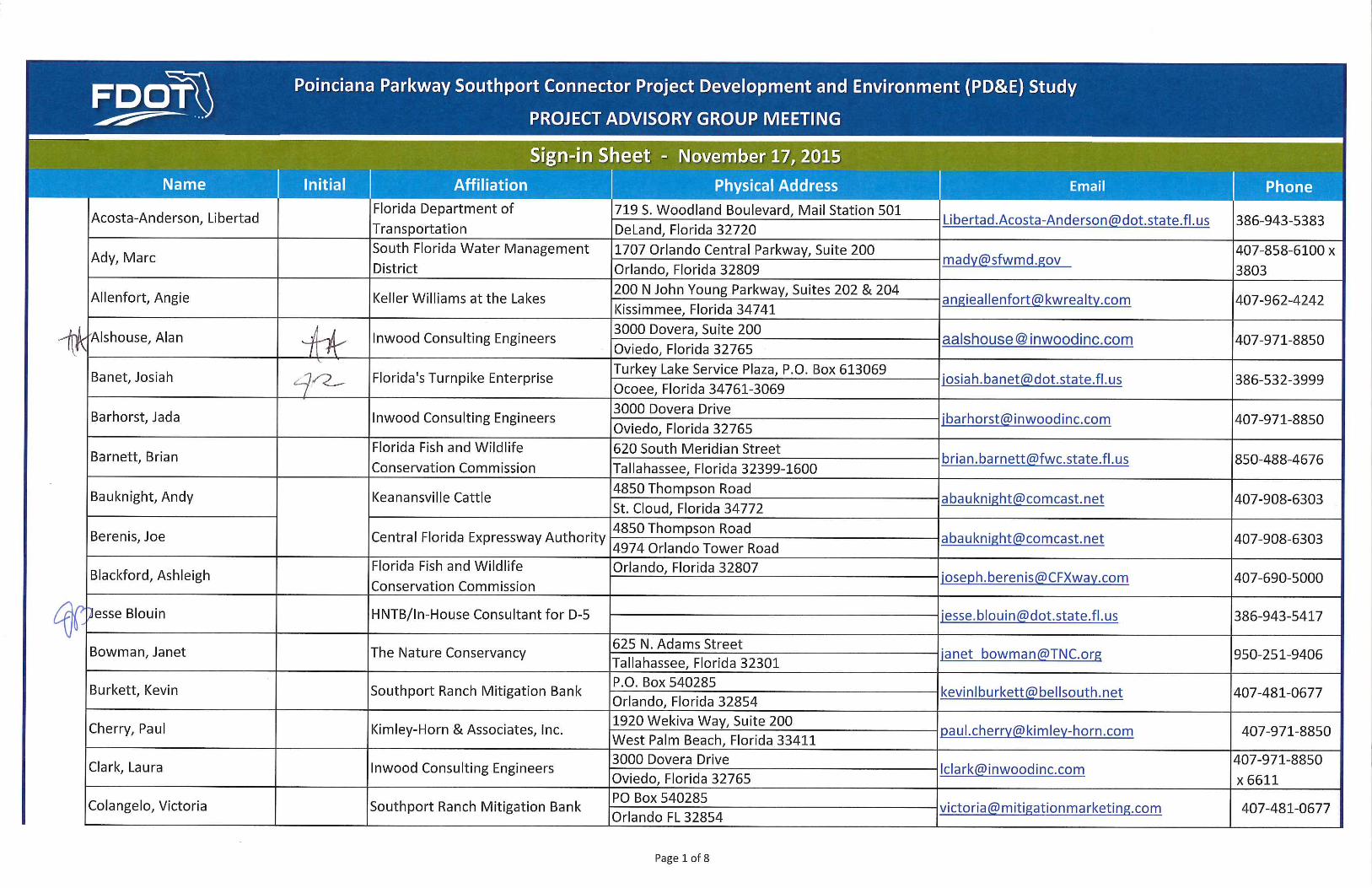
ATTENDEES: See Sign-In Sheet
ATTACHMENTS: Sign-In Sheet
1) Introductions and Purpose of the Meeting
The Agency Project Advisory Group (APAG) meeting began at approximately 10:00 am with
Amy Sirmans, FDOT Project Manager, reviewing the presentation agenda and providing an
overview of the project status.
Alex Hull, Consultant Project Manager, gave a brief overview of the status of the project,
including the corridor analysis / Alternative Corridor Evaluation Report (ACER), the ten initial
corridors and related screenings, and the recommended corridors (Corridors 7, 12, and 13).
2) Alex gave a PowerPoint presentation, which focused on the ten initial corridors, the screening
process, public and agency input, and the three recommended corridors. Alex went through the
agency input received, which is discussed below, and answered questions and took comments
throughout the presentation.
Agency Input
o Florida’s Turnpike Enterprise (FTE) – FTE provided email correspondence related to
interchange spacing relative to the Kissimmee Park Road interchange and the Canoe
Creek Service Plaza. The FTE input stated that the proposed interchange location for
Corridor 1 was too close to the Kissimmee Park Road interchange and that the proposed
interchange location for Corridors 6 and 8 were too close to the Canoe Creek Service Plaza
exit ramps. Corridors 1, 6 and 8 were determined to be non‐viable.
o Green Island DRI – Green Island DRI provided comments requesting that several
additional corridors be considered that would provide direct access to the Southport
Connector from the Green Island DRI. Based on this input and considering that Corridors
6 and 8 were eliminated, Corridor 11 was developed.
o Audubon Florida – Audubon Florida provided comments stating that the environmental
impacts assessment overstated the impacts to Corridor 1 and understated the impacts to
the corridors located south of Lake Tohopekaliga. Audubon Florida stated that Corridor 1
could serve the broadest range of local and regional transportation needs and

AGENCY PROJECT ADVISORY GROUP COORDINATION MEETING
2
recommended that Corridor 1 be carried forward for further consideration. To meet this
request, the study team extended the limits for evaluation purposes of all the corridors
south of Lake Tohopekaliga from Pleasant Hill Road along Cypress Parkway to Poinciana
Parkway. This extension provided for a comparable transportation network connection
and a fair comparison of impacts between Corridor 1 and the corridors south of Lake
Tohopekaliga. The result of the analysis was that Corridor 1 had higher impacts and higher
estimated costs than the other corridors being considered for further evaluation.
Therefore, the elimination of Corridor 1 from further consideration was confirmed.
o The Nature Conservancy (TNC) – TNC had concerns with Corridors 7 and 11 and the
proximity to managed lands and related smoke management. Corridors 12 and 13 were
developed to address these issues. Corridor 11 was eliminated from consideration
because it offered no advantages over the other corridors being considered and had the
disadvantage that it was closer to the TNC‐managed lands.
o Southport Ranch – Southport Ranch provided an avoidance corridor. Corridors 12 and 13
best addressed the concerns raised by Southport Ranch.
Charles Walter of the SFWMD asked what entity would be responsible for designing and
constructing the roadway and, ultimately, who would be responsible for maintaining it.
o Alex responded by saying that, at this time, FDOT District 5 is administering the PD&E
Study process; however, this is an Osceola County Expressway Authority (OCX) project. It
was noted that the project is not currently funded for design and that alternate delivery
methods, such as a Public‐Private Partnership (P3), could be an option.
o Amy added that there was not currently any funding for the design phase but that the
decision regarding funding would need to be made in the future in order for FHWA to
approve the PD&E Study. This approval is known as Location Design Concept Acceptance
(LDCA).
o Jeff Jones OCX stated that discussions regarding the next steps included OCX, CFX, and
FTE as well as P3 options.
3) Alex added that, after reviewing the input received, the study team is recommending Corridors 7,
12, and 13 for further study in the PD&E Study phase. It was then mentioned that comments were
received from the majority of the Environmental Technical Advisory Team (ETAT) and that an
extension could be requested from agencies that hadn’t yet provided comment on the ACER, such
as SFWMD.
Charles asked if the ACER was submitted to the SFWMD for review. Alex responded by saying
that the ACER had been submitted via ETDM and was available to SFWMD ETAT staff. Charles
mentioned that he would check on the status of comments on behalf of the agency.
4) The discussion then went into next steps and included discussion on officially beginning the PD&E
Study phase, the class of action, design traffic, the interchange justification report and detailed
alternatives analysis to include more detailed geometric design, the typical section and alignment
alternatives, and costs.

AGENCY PROJECT ADVISORY GROUP COORDINATION MEETING
3
Jan Everett with AECOM, which is a consultant to OCX, suggested that Alex review the
differences between an Environmental Assessment and Environmental Impact Statement
(EIS). Alex then reviewed the basic differences between the two documents.
Alex explained that the Alternatives Workshop would be the next public meeting and that all
of the alternatives carried forward would be given equal consideration.
5) Keith Laytham of Poinciana Residents for Smart Change asked when the study will be complete.
Alex mentioned that PD&E studies will generally take between two and four years, if not
longer, to complete. Amy also mentioned that the project was not currently funded for design
and that design funding would be required for LDCA.
6) John Ryan of the Sierra Club asked who would decide on the recommended / preferred
alternative.
Alex explained that the selection of a recommended / preferred alternative is based on
significant data and analysis, public and agency input, and collaboration with all parties
involved in order to select the option that best satisfies the project’s purpose and need and
minimizes impacts to the natural, social, cultural, and physical environment. Alex advised
John to stay involved in the process.
John commented that prescribed fire for land management will still take place in the area and
that fire will need to be dealt with outside of the smoke shed. He suggested notifying local
governments.
o Atlee Mercer, OCX Chairman, asked how often TNC does a burn.
o Jason Houck with Inwood responded that he could not speak for TNC regarding their burn
frequency and that he would request that information from them.
7) Dan Lackey with Bronson Properties asked if consideration was being given to a connection to
Canoe Creek Road.
Atlee mentioned that it is OCX’s / the County’s intention to provide access from Canoe Creek,
which could possibly occur by building a local road.
Keith mentioned that this connection was critical.
8) Charles suggested that a regional storm water treatment plan be developed / considered in
coordination with the DRIs in the area.
The meeting concluded at approximately 10:50 am.
END OF MEETING SUMMARY
Note: These meeting minutes are a summary of items discussed and reflect the writer’s understanding of the contents of the meeting. This summary will be considered final unless revisions are requested within ten (10) days of receipt.