appendix 1. raw water quality guidelines for rand …
TRANSCRIPT

i
Appendix 1.
RAW WATER QUALITY GUIDELINES FOR RAND WATER
M C STEYNBERG
R HEATH
F C VILJOEN
Version 1
FEBRUARY 1996
RAW WATER QUALITY GUIDELINES FOR RAND WATER
The purpose of this document is to introduce Rand Water’s raw water1 quality guidelines.
These are required for catchment management based on receiving water quality objectives.
The attainment of these guidelines in the raw water sources will ensure that the present
treatment technology used by Rand Water will be able to purify water complying to strict
international criteria.
These proposed Rand Water raw water quality guidelines will act as an interim measure to
ensure that raw water quality do not deteriorate below these levels. The guidelines will be
updated as new information becomes available.
How were these receiving quality guidelines compiled?
The purification process used by Rand Water can remove almost all the suspended materials
in the raw water. This implies that Rand Water can, with reference to specific variables,
allow water quality to deteriorate, because technology used can purify water to the required
standard. In such cases other water users, such as the environment, will be affected. For
example, the presence of dead fish in the raw water, due to the build-up of lead which can be
removed by Rand Water’s technology, is not likely to convince the consumers of potable
water, that the water they drink, is safe and healthy. During the formulation of these
guidelines direct use of the raw water for potable purposes was not taken into account.
ii
Substances in solution may or may not be removed, depending on the chemical reactions
involved. Sulphate and sodium, for example are not removed. This implies that for the
management of raw water sources, the same guidelines as for potable water, have to be used.
Using the above philosophy, Rand Water compiled 1raw water quality guidelines taking
cognisance of the requirements of the three main users of it’s raw water i.e. the aquatic
ecosystem, potable water producer and recreation. Primarily Rand Water will manage raw
water sources for potable purposes, but will take cognisance of the other user requirements,
especially if they are more stringent.
The efficiency by which specific variables are removed by the different unit process, was
determined using standard stirring test which simulated the worst case scenarios. The
percentage removal of the relevant variable was used as the factor by which the potable water
guideline was multiplied to indicate the concentration that can be tolerated in the raw water
source.
This value was compared to published values to aquatic life and for recreation. In most cases,
the value derived from the removal efficiency, was the most stringent. In the few cases
where it was not, the guidelines for the aquatic ecosystem2 or recreation was used.
1 Raw water is defined as the water in rivers and dams used by Rand Water as source for the production of potable water. 2 The latest guidelines of the Department of Water Affairs and Forestry (1995) was not taken into consideration

iii
Units Rand Water Recommended Limits
1. Physical & organoleptic
Alkalinity mg/l CaCo3 >65
Colour mg/Pt 20
Conductivity mS/m (25C) 70
DOC mg/l 10
Dissolved oxygen % sat. 30-70
pH pH units >7 - <9
2. Micro-elements
Antimony ug/l 100
Arsenic ug/l 90
Beryllium ug/l 2
Bismuth ug/l 250
Cadmium ug/l 5
Chromium ug/l 50
Cobalt ug/l 250
Cyanide ug/l 100
Gold ug/l 5
Lead ug/l 80
Mercury ug/l 2
Molybdenum ug/l 50
Nickel ug/l 100
Selenium ug/l 10
Selenium ug/l 10
Tellurium ug/l 10
Thallium ug/l 20
Tin ug/l 400
Titanium ug/l 1000
Tungsten ug/l 1000
Vanadium ug/l 500

iv
Constituent Units Rand Water Recommended Limits
3. Macro-elements mg/l
Aluminium mg/l 1.5
Ammonia mg/l 1.0
Barium mg/l 0.5
Boron mg/l 0.5
Bromide mg/l 1.0
Calcium mg/l 150
Chloride mg/l 100
Chlorine mg/l 0.1
Copper mg/l 1.0
Fluoride mg/l 1.0
Iodide mg/l 0.5
Iron mg/l 1.0
Lithium mg/l 2.5
Magnesium mg/l 70
Manganese mg/l 0.2
Nitrate mg/l 3.0
Nitrate/Nitrite mg/l 20
Ortho-phosphate mg/l 0.3
Potassium mg/l 20
Sodium mg/l 100
Sulphate mg/l 200
Uranium mg/l 4.0
Zinc mg/l 5.0
4. Microbiological
E. coli per 100 ml 126
Faecal coliforms per 100 ml 150
Coliphages per 100ml 20
Enteric viruses TCID 50/10L 1
5. Biological
Chlorophyll ug/l 30
Blue-green algae cells/ml 1500
Blue-green toxin (mycrocystin) ug/l 3
Acute toxicity tests:
Guppy
Daphnia
survival
survival
50% in 24h
50% in 24h
6. Other
MBAS mg/l 0.3
Phenol mg/l 200
v
Appendix 2.
WEEKLY RECREATIONAL WATER QUALITY REPORT
SUITABILITY OF WATER IN THE VAAL RIVERBARRAGE RESERVOIR FOR WATER CONTACT SPORTS
Suikerbosrant River
Klip River
Taaibosspruit
Vaal River
Leeuspruit
Not to scale
Rietspruit
Barrage
8
7
6
5
41
2
3
Luciana Country Club
Three Oaks Boatel(Club Nautique)
Shores of Lochvaal
Village ManorRietspruit Weir
Riverside Sun Hotel
Emfuleni ParkAscot Bridge
Lethabo Weir
LETHABO INTAKE
SASOLBURG
VANDERBIJLPARK
VEREENIGING
Railway Bridge
R26 Freeway Bridge
Riviera Aquatic Club
Dickinson Park
Vosloo ParkRiviera International Hoteland Country Club
F.W. De KlerkBridge
Eligwa Club
AbrahamsrustPleasure Resort
ClavadelCaravan Park
Baddrif Bridge
VaalviewAquaticClub
Lochvaal Club
INTERPRETATION OF THE RESULTS OBTAINED ON WATER SAMPLESCOLLECTED AT THE RESPECTIVE SAMPLING POINTS (REFER MAP)
DISCLAIMER: Although Rand Water has made every endeavour to make an accurateassessment of the suitability of water for contact sports - based on publishedinternational criteria - neither Rand Water nor any of its officials shall beresponsible for any damage or health related problems that may result dueto the use of the Vaal River Barrage Reservoir for contact sports
Predicted symptoms due toalgal growth
Possible skin irritationPossible skin infectionPossible intestinal disorders #Floating scums
OdoursColour
Sampling points
1 2 3 4 5 6 7 8
Predicted symptoms due tobacteria
Possible skin infectionPossible intestinal disorders #
Sampling points1 2 3 4 5 6 7 8
# if ingested X Symptom predicted
Toll Free Number: 0800113442
N

vi

vii
Appendix 3.
THE VAAL RIVER COMPLEX GUIDE PLAN (1982): ANNEXURE C
THE VAAL RIVER BARRAGE AREA AND THE TRIBUTARIES OF THE VAAL
RIVER (RIET SPRUIT, KLIP RIVER, SUIKERBOSRANT RIVER, WILGE RIVER
AND TAAIBOS SPRUIT).
2.1 The Vaal River Barrage area and the tributaries of the Vaal River (Riet Spruit, Klip
River, Suikerbosrant River, Wilge River and Taaibos Spruit).
2.1 An open space of at least 100 m, measured horizontally from the relevant base line*,
shall be left and no buildings or structures shall be erected or caravan parking and camping
take place on this space; Provided that -
(a) with the written consent of the Department of Health and Welfare, granted after
consultation with the Rand Water Board, the relevant local authority and other interested
government bodies, boat and water-pump houses, jetties and access roads as well as parking
facilities, tennis courts, golf courses, swimming pools, picnic sites and other recreational
facilities that do not constitute buildings or other permanent structures may be permitted in
the open space;
(b) when townships and holiday townships are established, only erven used for open space
purposes may be permitted in the open space; Provided further that no buildings may be
erected below the flood control line (as defined in par. 5.12); and
( c) caravan parking and camping may be permitted in the open space with the written
consent of the Department of Health and Welfare, granted after consultation with the Rand
Water Board, the relevant local authority and other interested government bodies.
2.2 Except with the written consent of Rand Water Board no habitable buildings or
structures, toilets, french drains, conservancy or septic tanks, sewage pumping installations or
sewage works shall be permitted below the flood control line, as defined.
viii
2.3 The width of the water frontage of any property other than existing properties, whether it
forms part of any township, holiday township, or holiday resort (including club sites and
caravan parks), shall be at least 100 m, measured horizontally.
*(1) With regard to the development of land along the Vaal River of determining the base line, viz.:
(a) the lower zone which stretches from Engelbrechtsdrif corresponds more or less with the 1421,0
contour)
(b) the upper zone from Engelbrechtdrif up to the Vaal Dam
(2) With regard to the development of land along the tributaries of the Vaal River the edge of
the water course forms the baseline.
2.4 Except with the written consent of the Department of Health and Welfare, granted after
consultation with the Rand Water Board, only one dwelling with such outbuildings as are
normally required for the use thereof may be erected on any holding or farm portion in the
area within 500 m of the base line, as defined; Provided that staff houses at holiday resorts
(including those at caravan parks and club sites) shall be exempt from this provision.
2.5 Holiday resorts, caravan parks and camping sites shall, apart from complying with the
above requirements, conform to the requirements of the local authority concerned and any
relevant health regulation. No alienation of erven or permanent occupation of stands or
buildings (excluding. dwellings of managers and/or caretakers) shall be permitted.
2.6 Where overnight facilities are provided at any resort (including caravan parks and club
and camping sites) no visitor shall be permitted to reside in the resort for longer than three
calendar months in any twelve-month period.
2.7 Where owners and/or occupiers make their land available to the public for fishing and/or
recreational purposes, the above requirements shall be complied with and satisfactory toilet
facilities, which comply with the requirements of the Department of Health and Welfare and
the Rand Water Board, shall be provided.
2.8 Any animal feeding system that is established shall comply with the relevant health

ix
regulations.
2.9 All sanitary facilities shall comply with the requirements of the Rand Water Board.
(b) by the substitution for paragraph 2.10 of the following paragraph:
2.10 Any of the provisions, as set out in this Annexure in respect of the Vaal River Barrage
area may be relaxed with regard to a specific property or area by the local authority
concerned, with the written consent of the Rand Water Board after consultation with the
Director-General of the Department of Water Affairs and the Department of National Health
and Population Development: and
(c ) by the addition of the following paragraph after
paragraph 2.10:
2.11 any of the provisions, as set out in this Annexure in respect of the tributaries of the Vaal
River (Riet Spruit, Klip River, Suikerbosrant River, Wilge River, Taaibos Spruit and
Leeuw Spruit), may be relaxed with regard to a specific property or area by the local
authority concerned, with the written consent of the Director -General of the Department of
Water Affairs and after consultation with the Rand Water Board and the Department of
National Health and Population Development.
* (1) With regard to the development of land along the Vaal River Barrage area, the area
can be divided into two zones for purposes of determining the base line, viz.:
a) the lower zone which stretches from Engelbrechtsdrif up to the Barrage where the full
supply line (which is surveyed and corresponds more or less with the 1421,o contour)
forms the base line, and:
b) the upper zone from Engelbrechtsdrif up to the Vaal Dam where the edge of the water
course forms the base line.
(2) With regard to the development of land along the tributaries of the Vaal River the
edge of the water course forms the base line.

x
Appendix 4.
PROPOSALS FOR THE GUIDANCE OF RAND WATER BOARD OFFICIALS IN
DETERMINING WHEN AND UNDER WHAT CIRCUMSTANCES SUPPORT COULD
BE GIVEN TO OWNERS OF PRIVATE RESIDENTIAL PROPERTIES* SITUATED
WHOLLY OR PARTLY BELOW THE MAXIMUM LEVEL OF THE ONE-IN-FIFTY-
YEAR FLOOD (“THE FLOOD LEVEL”) WHEN APPLYING TO ERECT OR EXTEND
DWELLINGS
PART ONE
Private residential buildings that were lawful before the enactment of the Vaal River
Complex Guide Plan 1982 but which are not in conformity with the provisions of the Guide
Plan
The Board should support an application to extend such buildings provided that:
(i) The total floor area of the structure after extension shall not exceed 115 per cent of the
floor area of that structure as it was at 5 August 1982. The total permissible floor area of
all the extensions made to such dwelling after the aforesaid date shall, however, not
exceed 50 m². If an owner wishes to effect more extensive extensions, a new residence
should be constructed above flood level and outside the 100 m building restriction zone –
the old building should then be demolished.
* On account of density of occupation implicit in other land uses, it is proposed that owners
of properties used for purposes other than private residence should be opposed when applying
to build below the flood level.

xi
PART TWO
Building erven that are situated wholly or partly below the flood level
(a) Attention is drawn to paragraph 2.1 of Part 2 of Annexure C of the Vaal River Complex
Guide Plan 1982 that prohibits the erection of residential buildings on the open space of
at least 100 m measured horizontally from the relevant base line.
(b) The Board should oppose an application to erect a residential building within the 100 m
open space or below the flood level where there is another building site or there are other
building sites on the property in question above the flood level on which a suitable
residence can be built.
(c) The Board should support an application to erect a dwelling between the open space and
the flood level only in those instances where paragraph (b) of this Part is not applicable,
provided that:
(i) The proposed dwelling is located as far away from the river as the relevant building
line restrictions imposed on the erf and other physical constraints will allow, or at the
highest building site within the flood plain in cases where the location of the structures on
the highest building site will be more advantageous to the Board;
(ii) The floor level of the dwelling and out -houses shall be raised above the flood level as
determined by the Board. Where the floor level is to be raised by more than one metre
the dwelling should be raised on stilts;
(iii) Septic tanks or conservancy tanks shall be so constructed that the manholes and other
inlets and outlets are above flood level;
(iv) Where part of the erf is above flood level, the percolation systems shall be placed
above flood level. Where the entire erf is below flood level a conservancy tank system
should be a requirement;

xii
(v) In the case of erven within municipal townships, support should only be given by the
Board if, in addition to the other requirements, the erf in question was in private
individual ownership on or before 5 August 1982 and the township is sewered by the
municipality.
PART THREE – GENERAL
(a) The Board should only support applications as envisaged in Part Two hereof in respect of
erven that were in existence as at 5 August 1982 and not in respect of subsequent sub-
divisions thereof.
(b) The Board’s support of applications under Part One or Part Two hereby shall be made
conditional upon the applicant waiving and abandoning any claim whatsoever that he or
his successor -in-title may have against the Board arising from or out of the flooding of his
dwelling or the partial submergency thereof by the Board in the exercise of its statutory
powers. This waiver shall be registered at the applicant’s expense against his title deeds.
Additional relaxation approved by Rand Water Chief Executive and General Manager
– Scientific Services on 7 March 1996:
Extensive additions to an existing dwelling below the 100 m Building Line but above the
1975 Flood Line were approved by the Chief Executive after consultation with the General
Manager: Scientific Services and the Legal Services Manager. These extensions amount to
more than doubling the size of the original dwelling i.e. the total floor area after extensions
exceeded 200 per cent of the original floor area. It is important to note that this relaxation
applies only to the 100 m Building Line.
This approval has been used as a precedent since 7 March 1996 for all similar applications.
xiii
Appendix 5.
PROPOSED FLOOD PLAIN DEVELOPMENT POLICY.
(From Stephenson, 2001)
The channel which is generally occupied by flow during low flows is referred to as the river
channel. The water line is seldom below this level. There could however be regular flooding
at successively higher water levels. There is an area which will be inundated regularly, i.e.
every few years, and this is referred to as the waterway. No development should be permitted
in the waterway as there is a real and frequent danger to life and property.
At a higher level, such as the 1 in 25 year flood, there is still a risk of flooding which could
endanger property or life but it does not occur frequently enough to be a nuisance. The area
within the boundaries of this flood would be called the flood zone, which comprises the
waterway and flood plains.
There is an area outside this flood zone at a higher level which could be flooded even less
frequently and this area is referred to as the flood fringe. This extends to the limits of the 50
year flood, although the Water Act of 1998 now requires the 100 year flood to be indicated
on plans.
Above the 100 year flood line, the possibility of flooding is so remote, it is seldom accounted
for in planning, but it should be borne in mind in important developments, e.g dangerous
depositories.
Delimitations of the different zones could be based on the following;
a) Waterway: either
i Covered by a common flow, for example 10 years or less,
ii 90% of the 50 year flood
iii velocity greater than 1m/s
iv depth greater than 1m
v a combination of i, iii, and iv, which gives a flood hazard risk index of 2 or less.

xiv
b) Flood plain: outside of (a) but bounded by either
i 1975 flood line (estimated to be the 25 year frequency flood)
ii 95% of the 50 year flood
iii velocity greater than 0,5m/s
iv depth greater than 0,5m
v a combination of I, ii, and iv, e.g a flood hazard index of 1 or less.
(c) Flood fringe: outside of (b) but bounded by either
i 50 year or 100 year flood line
ii no pollution source.
The suggested prohibition line below which development should be prohibited could be
based on a hazard-risk index of above 2. The boundary corresponds to the 10-year flood line
(nearer the Barrage, but the 5-year flood line further upstream).
For the upper limit of the flood plain, the 25-year flood line or 1975 flood line is suggested.
The 25-year line corresponds with the 1975 flood, measured and marked along the river
banks, hence it is a practical line to apply.
It would not be wise for floor levels of buildings to be below the 25-year flood line. Apart
from surface development, e.g roads, recreation areas on the ground, buildings will have
elevated floors.
The flood fringe (between 25-year and 50-year or 100-year flood lines) may also be
developed to an even greater density and development need not be banned in the flood fringe
as long as the developers and owners are aware of and responsible for the risk of flooding and
indicate this in writing. The flood lines should be indicated on all development plans, as well
as floor levels. The responsibility needs legal opinion, and insurance against hazards should
be considered.
xv
Appendix 6.
SANITARY REQUIREMENTS FOR THE VAAL RIVER BARRAGE RESERVOIR
AND ITS TRIBUTARIES
In terms of the provisions of the Rand Water Board Statutes (Private) Act, 19950 (Act 17 of
1950), Rand Water is empowered to take steps to prevent the pollution or likely pollution of
any water impounded and stored by Rand Water.
Development taking place on land adjacent to the waters under Rand Water’s control has
brought to light certain practices that constitute a danger of pollution, and Rand Water is
therefore compelled to set certain minimum safeguards concerning sanitary arrangements and
the disposal of sewage, wastewater, solid wastes, refuse and litter on any land adjacent to the
Barrage reservoir.
In terms of Clause 2.9 of Annexure C of the Vaal river Complex Strucutre Plan (see
Appendix 3) C Rand Water’s prior approval of the method of disposal of sewage and trade
and domestic wastes should be obtained in cases where a change in usage of land is
contemplated or where a building is to be constructed or altered on land adjacent to Rand
Water’s marginal property strips on the Vaal River Barrage reservoir or its tributaries or on
land that abuts on or is close to the water’s edge. No sanitary installations will be permitted
on Rand Water’s property.
The following requirements are published for information and as a general guide to interested
parties :
1) Sanitary arrangements
The following sanitary arrangements will be considered where up to 20 dwelling units or 100
persons are concerned :-
2) Septic tanks with associated percolation systems (French drains).

xvi
3) Conservancy tanks or night-soil privies on condition that the contents are removed by a
local authority for full biological and/or chemical treatment.
4) Chemical closets, in special circumstances only, and on condition that the contents are
disposed of not less than 100 metres from the boundary of the property abutting Rand
Water’s marginal strips or the water’s edge.
Flow of sewage and wastewater to septic tanks, percolation systems and conservancy tanks
shall be by gravity. Pumping will not be permitted, except under exceptional circumstances.
Where more than 20 dwelling units or 100 persons are concerned, full biological or other
treatment approved of by Rand Water shall be provided to give an effluent that will conform
to the requirements (other than bacteriological) of the General Standard for Industrial
Effluents laid down in Notice R553 promulgated in Government Gazette Extraordinary 217
(Regulation Gazette 75) dated 5 April 1962. The effluent shall not contain more than 1 000
E. coli type I organisms per 100 millilitres. The effluent shall be disposed of by some means
other than discharge directly or indirectly into the Vaal Barrage reservoir.
5) Percolation systems
The effluent from septic tanks shall flow into percolation systems (French drains) of a design
approved of by Rand Water and having subsoil sidewall infiltration areas based on the
permissible rates of application of effluent corresponding to the measured water percolation
rates in test holes sunk in the subsoil at the percolation field sites.
The infiltration area for a house not exceeding 200 square metres shall not be less than 14
square metres; for a house of greater area Rand Water will, on application, specify the
required infiltration area.
The above requirements shall also apply in the case of “two pipe” systems in which kitchen
and bathroom wastewaters by-pass the septic tanks and enter separate French drains or soak
pits of a design and capacity approved by Rand Water, after passing through effective grease
traps.

xvii
6) Location of septic tanks and percolation systems
Septic tanks and their associated percolation systems shall be situated –
7) not less than the following distances from the boundary of the property abutting on Rand
Water’s marginal strips or the water’s edge :-
Houses, flats, chalets, hotels,
camps and caravan parks
Distance from
water’s edge
Systems serving up to 10 dwelling
units.
100 metres
Systems serving 11 to 20 dwelling
units.
150 metres
In addition, the percolation system shall be so situated that there is an area within the
property, between the percolation system and the water’s edge, of at least 250 square metres
for each person who can be accommodated.
In the case of hotels, two bedrooms shall be taken as equivalent to one “dwelling unit”;
8) at positions where the normal water table is not less than 2 metres below ground level;
9) at positions above the expected high flood level (available from Rand Water’s Chief
Engineer).
Notwithstanding 3 (I), (ii) and (iii) above, should it be found that the effluent from the
percolation system is finding its way into the Vaal Barrage reservoir or its tributaries, such
further measures as Rand Water may require shall be taken to eliminate such discharge into
the reservoir or its tributaries.
10) The location, capacity, design and construction of septic tanks and percolation systems
shall be subject to written approval by Rand Water. Rand Water has the right of regular
access for inspection.
11) Solid wastes, refuse and litter

xviii
Solid wastes, refuse and litter shall be deposited in holes and covered with not less than 0,5
metre of soil.
The holes for such deposits shall be situated not closer to the water’s edge than the positions
of the percolation systems as determined under 3 above.
12) General
The attention of property owners is also drawn to the following :-
13) the Public Health Act, 1919 (Act 36 of 1919);
14) the Department of Health’s General Health Regulations promulgated in terms of the
Public Health Act, 1919, under Notice R180 in Government Gazette Extraordinary 1652
(Regulation Gazette 756) dated 10 February 1967;
15) the Uniform Public Health By-Laws and Regulations (Administrator’s Notice 148 of 21
February 1951 (Transvaal));
16) the Public Health By-Laws of other municipalities and local authorities not include d in
the Schedule to the Uniform Public Health By-Laws and Regulations referred to in (iii)
above;
17) the various Standard Conditions of the Transvaal Board for the Development of Peri-
Urban Areas in respect of sanitation requirements within its area of jurisdiction.

xix
Appendix 7.
USE OF THE BOARD’S RESERVOIR AND LAND RIPARIAN TO THE VAAL
RIVER BARRAGE RESERVOIR AND ITS TRIBUTARIES BY OWNERS OF LAND
ADJACENT THERETO.
The following is published as a general guide regarding the reservoir and land use and the
types of structures which the Board is usually prepared to permit in its reservoir and on its
land riparian to the Vaal River Barrage and to its tributaries by owners of private property
adjacent thereto. The use of the Board’s reservoir and land as well as the erection and
occupation of all structures therein and thereon and access thereto are entirely at the owner’s
risk and at the will and pleasure of the Board and not by virtue of any right.
The Board may, at any time, call upon the owner to give up occupation of the Board’s
reservoir and land or any portion thereof and remove or alter any structures thereon or therein
at such owner’s cost and expense, without damage to the land or the reservoir and without
any right or claim for compensation.
Where any structure or structures on the Board’s land and in its reservoir have been
previously approved by the Board but no longer comply with the Board’s prevailing
requirements, the Board may allow the structure or structures to remain on its land or in its
reservoir for a determined period eg the period of ownership of the present owner or any
specified fixed period as determined by the Board, or for any period up to twenty years in the
case of a company, and then call upon the owner or company to remove or alter the structures
to comply with the Board’s requirements.
The following structures may with the Board’s prior approval in writing be permitted and no
other structure or facilities of any kind shall be permitted on the Board’s land or in its
reservoir :
1. An open boat-shelter, with no rooms, verandah, or "lean-to” attached, capable of
housing not more than two boats belonging to the owner of the adjacent property. The boat
shelter shall be situated wholly in the reservoir and shall not be attached to any structure
erected on the owner's land. The roof of the boat shelter shall not be used as a sundeck,

xx
balcony, or for any other similar purpose. The details of design and dimensions of the boat
shelter shall comply with the details as depicted on the enclosed print of drawing A9103.
The total width shall not exceed 6 metres and the length shall not exceed 9 metres into the
reservoir at full supply level. The boat shelter shall comprise a platform not more than one
metre wide, supported above full supply water level on columns to permit free movement of
water along the river banks to avoid stagnant water areas that may promote silting or weed
growth. No excavation of the river banks will be permitted.
2. A slipway or launching ramp.
Drawings showing details of design, dimensions and materials of construction of all such
structures shall be submitted to the Board for prior written approval and the preparation of a
Deed of Acknowledgement. It is reiterated that no structures shall be permitted to remain on
the Board’s land or in its reservoir if constructed without the Board’s prior written approval
having been obtained.
When the structures have been erected to the Board’s satisfaction, the owner shall sign and
execute a Deed of Acknowledgement, the terms and conditions of which shall be fixed by the
Board to regularise the use of its land and reservoir.
Not more than two boats belonging to the owner may be launched from the Board’s land
unless prior permission in writing has been obtained from the Board.
In addition to the above requirements, attention is also drawn to the requirements of
Annexure C of the Vaal River Complex Guide Plan, 1982, that no buildings or structures
shall be erected or caravan parking and camping take place in an open space of at least
100 m, measured horizontally from the relevant base line in the Vaal River Barrage area and
the tributaries of the Vaal River and that the written consent of the Department of Health,
granted after consultation with the Rand Water Board and other interested government
bodies, must be obtained before boat-houses and water-pump houses, jetties and access roads
as well as parking facilities, tennis courts, golf courses, swimming pools, picnic sites or other
recreational facilities that do not constitute buildings or permanent structures may be
permitted on the owner’s land within the 100 m open space.
July 1992

xxi
Appendix 8.
REGULATIONS FOR BOATING ON THE VAAL RIVE R BARRAGE RESERVO IR.
This booklet, which is intended to be kept as a ready reference on board of boats that have
been permitted by Rand Water to use the Vaal River Barrage reservoir, contains the
following:-
Part 1
Conditions for boating on the Vaal River Barrage reservoir
1 to 7
Part 2
Permit conditions
8 to 9
Part 3
Types of boats permitted on the Barrage reservoir and related matters
10 to 11
1994
PART 1
CONDITIONS FOR BOATING ON THE VAAL RIVER BARRAGE RESERVOIR
The following conditions shall be adhered to by all permit holders. Failure to do so could
result in the withdrawal by Rand Water in its absolute discretion of a permit to operate a boat
on the Vaal River Barrage reservoir.
1. DEFINITIONS
1.1 For the purposes of Parts 1, 2 and 3 hereof -
“Barrage reservoir” shall mean the Vaal River Barrage reservoir
“Boat” shall mean any object used or designed for navigation or use on or in
water.
“Permit” shall mean a permit or temporary permit issued by Rand Water for
the use of a boat on the Barrage reservoir.

xxii
2. OPERATION OF BOATS
2.1 No person shall use or allow a boat to be used on the Barrage reservoir in a
way that might endanger or be of annoyance to the owners or occupants of
other boats or to people on the banks of the Barrage reservoir.
2.2 No person in charge of a boat shall carry therein more persons than the
maximum number authorized.
2.3 The pilot of any boat shall be in a position to exercise full control of his boat
at all times.
2.4 The owner of a boat designated on the permit shall be responsible for the
proper use and maintenance of the boat and shall be held responsible for any
damage or loss caused by the use or presence of such a boat on the Barrage
reservoir.
2.5 A boat shall not be left unattended on the Barrage reservoir unless it is
properly moored or anchored at a safe distance from the waters edge.
2.6 All official notices, water tariff signs and signals shall be observed at all times.
2.7 No person shall control a motor boat on the Barrage reservoir -
2.7.1 unless he is at least 16 years of age or does so under the immediate
supervision of a competent pilot of at least 18 years of age who shall
accept responsibility for the conduct of the younger pilot.
2.7.2 while under the influence of alcohol, narcotics or drugs.
2.8 No motor boat shall approach to within 15 metres of another boat except -
2.8.1 when physical circumstances are such that the abovementioned
distance cannot be adhered to; or

xxiii
2.8.2 assistance is being rendered in an emergency situation; or
2.8.3 the boat is about to return to a jetty or bank or depart from such jetty or
bank.
2.9 If the above -mentioned distance cannot be adhered to, the boat shall
immediately reduce speed to less that 10 knots (18 km/h).
2.10 No boat shall follow closer than 100 metres in the wake of a boat towing a
water skier or aquaplanist.
2.11 No person shall jump or dive from a propeller driven boat that is under way.
2.12 All engines on a boat shall be stopped before any attempt is made to pick up a
persons from the water.
2.13 No person shall be allowed on the bow, foredeck or gunwale of a power-
driven boat while under way unless the boat is designed for passengers to be
accommodated on the bow, foredeck or gunwale and is adequately fitted with
rails or screens.
2.14 A boat under way has the right of way over a boat making way from a bank,
jetty, wharf or restricted water to the open water and a boat making way has
no right of way until it is in open water.
2.15 All boats shall keep to the right (starboard) of the center line of the reservoir.
2.16 Circuits by motor boats shall wherever possible be carried out in an anti-
clockwise direction.

xxiv
3. AVOIDANCE OF AND REPORTING OF ACCIDENTS
3.1 When two boats approach each other head on, each pilot shall steer so as to
pass the other on his own port (left) side at such a distance and such a speed
that the wake of either boat will not endanger the other.
3.2 A boat overtaking another traveling in the same direction shall keep well clear
of the boat being overtaken and shall overtake only when it is absolutely safe
to do so, and only at such a distance and speed that the boat being overtaken is
not in any way endangered.
3.3 A boat being overtaken shall maintain its speed and course until the overtaking
boat has safely passed.
3.4 In a crossing situation, the boat has the other on its port (left) side shall
maintain its course and speed. The boat that has the other on its starboard
(right) side shall stay clear of it by changing course to starboard in order to
pass astern of the other boat, or stop and if necessary reverse to avoid a
collision. A crossing situation arises when two boats approach each other at
an angle where there is the risk of collision, but one boat overtaking another
does not give rise to a crossing situation.
3.5 A motor boat gives way to all other types of boat except when being
overtaken.
3.6 A boat propelled by oars gives way to a boat propelled by sail, except when
being overtaken.
3.7 A motor boat wishing to change course or speed shall indicate its intentions to
all other boats that may possibly be affected.
3.8 Should an accident occur in which a person is injured or killed, or damage is
done to any property, the accident must immediately be reported to the nearest
police station and office of Rand Water.
xxv
3.9 A boat not participating in a competition shall keep clear of any area in use of
boats or persons engaged in any such competition.
4. WATER SKIING
4.1 All persons shall wear adequate personal buoyancy whilst water skiing unless
skiing under competitive conditions.
4.2 No steel or other metallic rope or wire shall be used to tow water skiers.
4.3 In addition to the pilot, one competent person shall be in the towing boat to
watch the skier, or the pilot shall use a wide angle rear view mirror.
4.4 The pilot of a motor boat shall ensure that every water skier he tows knows at
least the hand signal requiring the pilot to stop immediately. This signal is a
hand or arm drawn across the throat.
4.5 The pilot of a boat using a line, rope or cable for towing shall be responsible to
ensure that no damage or personal injury is thereby caused to another. As
soon as the two is dropped by a water skier the towing boat shall either stop
and pull in the two or, if the two was accidentally dropped, shall reduce speed
and return immediately to pick up the water skier.
4.6 Every towing boat shall carry a red flag which shall be clearly displayed when
the boat is engaged in picking up a water skier.
4.7 No person under the influence of alcohol, narcotics or drugs shall be permitted
to ski or ramp jump.
4.8 No water skiing will be permitted on the reservoir where it extends into the
Suikerbosrant and Klip Rivers and the Taaibos, Leeuw and Riet Spruits
(situated on the Orange Free State side of the reservoir).

xxvi
5. EQUIPMENT FOR BOATS
5.1 Every boat in use on the Barrage reservoir shall carry the following equipment
:-
5.1.1 One or more suitable paddles or oars.
5.1.2 A life saving device of a design approved by the South African Bureau
of Standards, for each person on board.
5.1.3 Pumping or bailing apparatus, unless the boat is so constructed that it
will support all occupants when completely swamped.
5.1.4 In the case of a motor boat, an adequate fire extinguisher which must
be readily available for immediate and effective use.
5.2 Engine compartments shall be adequately ventilated and inboard engines shall
be fitted with adequate backfire arresting devices.
5.3 No motor boat shall be operated unless the exhaust noise is effectively
silenced. This rule shall not apply at regattas or speed trials recognized by the
South African Power Boat Association and approved by Rand Water.
5.4 No person shall use a boat on the Barrage reservoir from half an hour after
sunset to half an hour before sunrise unless such boat, if it is power-driven,
displays -
5.4.1 a bright white light on the stern visible from all directions from a
distance of at least one kilometer; and
5.4.2 a combination light on the bow at a lower level than the white light,
which shall project green to the starboard side and red to the port side
and which shall be visible at a distance of at least one kilometer.

xxvii
5.5 In the case of non a power-driven boat permitted to be on the Barrage
reservoir during the aforesaid hours, a lantern or torch shall be readily
available thereon to exhibit a white light in sufficient time to avoid a collision.
6. SPECIFIC REQUIREMENTS OF RAND WATER
6.1 Particular care shall be taken to ensure that no pollution of water takes place or
is likely to take place as a result of the use or presence of a boat on the Barrage
reservoir.
6.2 No person shall deposit any object, substance, used container, bottle, toilet
refuse, rubbish, garbage petrol, oil or other mineral product in the water or on
land bordering the Barrage reservoir except at such places or in such
containers especially provided for this purpose by a local authority, club or
resort owner.
6.3 Rand Water owns strips of riparian land on both sides of the Barrage reservoir
and has granted adjacent property owners certain rights of usage over such
land. No boat shall therefore be beached on or moored against such land
except with the permission of the adjacent property owner. In addition no boat
shall be beached or moored on islands in the Barrage reservoir except in an
emergency.
6.4 No boat shall enter waters that may be demarcated for bird, fish or nature
conservation or where such entry is prohibited by Rand Water and so indicated
by notices publicly displayed.
6.5 No person shall kill, injure, catch or disturb any animal or bird or remove nests
or eggs in the Barrage reservoir area.
6.6 No person shall chop down, damage, uproot or destroy any trees, reeds or
plants on Rand Water’s riparian land without permission from Rand Water.
xxviii
6.7 No person shall carry a firearm or any kind of weapon on his person or in a
boat whilst on the Barrage reservoir.
6.8 No buoy, pier, jetty, dock, launching ramp, anchorage or other obstruction
shall be constructed in the Barrage reservoir without the prior written consent
of Rand Water.
7. ORGANIZED SPORTING EVENTS
7.1 No organized sporting event shall be staged on the Barrage reservoir without
the prior approval of Rand Water.
7.2 Application for permission to stage such an event, giving full details of the
proposed arrangements, shall be made in writing to the Chief Executive of
Rand Water at P O Box 112, Johannesburg, 2000, at least 90 days in advance
of the intended date for the event.

xxix
PART 2
PERMIT CONDITIONS
(a) No boat shall be permitted on the Barrage reservoir unless its owner is in possession
of a valid permit issued by Rand Water.
(b) A permit is valid for a period of twelve months from date of issue and will be
renewable on each ensuing anniversary of such date. A temporary permit is valid for
1 day only.
(c) A permit is issued in the entire discretion of Rand Water and may be withdrawn at
any time.
(d) A permit issued in respect of a boat operating on the reservoir shall attach to the
owner of the boat and a permit is not transferable, with the exception of one permit
issued to the owner of a riparian property, which may be transferred to any purchaser
of such property.
(e) A registration number preceded with the letters RW will be allocated to the craft when
a permit is issued. The registration number shall be indelibly displayed on both sides
of the craft in black figures and letters with a minimum width of 50 mm and height of
100mm on a yellow background in such a position that it is distinctly visible and
legible at a distance of 20 metres.
(f) An identity disc will be issued with each permit and such disc shall be fixed to the
boat in a clearly visible position.
(g) The owner of a boat in possession of a permit shall ensure that the boat is operated in
a safe and acceptable manner and in accordance with any rules that Rand Water may
lay down from time to time. (See Part 1). Particular care shall be taken to ensure that
no pollution of the water takes place or is likely to take place as a result of the use or
presence of the boat on the Barrage reservoir.

xxx
(h) The ow ner of a boat may use it or permit it to be used on the waters of the Barrage
reservoir solely at his own risk and waives and abandons all claims whatsoever
against Rand Water. The owner of a boat furthermore indemnifies Rand Water
against claims instituted by others arising out of or from the use of the authorized boat
on the waters of the Barrage reservoir.
(I) The owner of an authorized boat shall operated the boat and ensure that others using
the boat operated the boat on the Barrage reservoir in conf ormity with any law or
regulation that governs or prescribes boating or any condition laid down by Rand
Water.
(j) An official representative of Rand Water may board a boat at any time to inspect
documents or the permit concerning the use of the boat and to ascertain whether the
boat complies with Rand Water’s requirements, and may order the pilot of any boat
used in any way contrary to Rand Water’s requirements to remove the boat from the
Barrage reservoir. When the pilot is so ordered, the boat shall be removed
immediately and shall not be used again on the Barrage reservoir without the written
consent of Rand Water.
(k) The permit quota for craft using the Barrage reservoir is 3 400 motor driven and 2 000
non-motor driven craft.
(l) The following permit fees, which may be altered from time to time, are payable :-

xxxi
R/Annum
Boats equipped with motors -
up to 15 kw
28
above 15 but not exceeding 100 kw
55
above 100 but not exceeding 200 kw
85
above 200 kw
165
Platform type craft
195
Non motorized craft
10
Authorized boats used for commercial purposes
200
Temporary permits (valid for 1 day)
10

xxxii
PART 3
TYPES OF BOATS PERMITTED ON THE BARRAGE
RESERVOIR AND RELATED MATTERS
(A) No boat providing living or sleeping accommodation, boat equipped with a toilet,
galley, wash basin or washing facilities of any kind, or restaurant boat, unauthorized
boat plying for hire, or unauthorized boat on which or in connection with which any
commercial enterprise is conducted, shall be permitted on the Barrage reservoir.
(B) No boat shall be used on the Barrage reservoir, even temporarily, as living or sleeping
accommodation.
(C) No wet-bike, jet-ski, raft, barge and certain pontoon type boat shall be permitted on
the Barrage reservoir, provided that the Chief Executive or his nominee may grant
special ad hoc authority to a specific organization or organizations to stage raft events
from time to time or to operate ski-jumps, place slalom courses and repair barges on
the reservoir on such terms and conditions as he may deem fit.
(D) Permits for certain platform type craft may in the discretion of Rand Water and
subject to certain conditions be issued.
(E) The maximum hull length and overall width of any craft allowed on the reservoir shall
not exceed 6,5 metres and 2,45 metres respectively, except in special circumstances
and then only with the ad hoc permission of Rand Water (e.g. in the case of an
international race meeting).
(F) No boat whatsoever shall be allowed on the Barrage reservoir without the authority of
a permit. A permit shall be valid for a period not exceeding one year and may be
renewed by Rand Water, on the application of the owner, for further periods not
exceeding one year at a time. A permit shall be issued in the absolute discretion of
Rand Water and any permit may be withdrawn by Rand Water at any time.

xxxiii
(G) No organized sporting event shall be permitted on the Barrage reservoir, but the Chief
Executive or his nominee may grant special ad hock authority to a specific
organization or organizations to stage such event on such terms and conditions as he
may deem fit and where he considers it necessary and in the interests of safety, the
Chief Executive or his nominee may exclude public from the Barrage reservoir or any
part thereof for the duration of the event.
(H) The storage, handling and transfer of fuel at or near the Barrage reservoir shall be
permitted only if carried out in such a way that there is no pollution of the water and
without in any way derogating from the generality of foregoing requirements, the
following minimum preventive and precautionary measures shall be observed:-
(i) Drip trays of adequate area and depth to accommodate portable fuel tanks
shall be provided and securely fixed to the jetties.
(ii) The drip trays shall be provided with drain pipes to drain split duel into
containers that can be removed and emptied periodically.
(ii) No potable fuel tanks shall be filled unless placed within the drip trays.
(iv) In cases where bulk fuel storage tanks are installed at positions below the 1975
flood line, details of which are available from Rand Water, they shall be
securely anchored to prevent floating of the tanks during the floods and shall
be fitted with watertight filler caps and vent pipes extending to a height above
the flood level
xxxiv
Appendix 9.
THE BOARD’S POWER TO CONTROL BOATING ON ITS VAAL RIVER
BARRAGE RESERVOIR
Ever since the Board decided to construct the Barrage Reservoir, it has questioned whether it
can exercise any control over boating and, if so, what form that control may take.
In order to impound and store water in the Vaal River it was necessary for the Board to
submerge certain land along the Transvaal and Orange Free State banks of the river. The
Board took the power to do this in one of two ways. It took ownership of the land, for a
distance of about 25,75 km upstream of the Barrage, along both banks. It acquired servitudes
for the remainder of the land to be inundated.
At the time the Board acquired ownership of and servitudes over the land to be inundated, the
land in the area consisted almost entirely of large farms, and the river frontage naturally
comprised the most valuable portions of the farms concerned. Because of this, Vereeniging
Estates Limited and African and European Investment Company Limited granted the Board
servitudes of submergence (not of storage) together encompassing 3 139,19 ha of land, free
of consideration 1 so as to induce the Board to accept something less than ownership. The
servitudes provided, at the ins istence of the companies, that the rights of submergence in
perpetuity granted to the Board were subject to the reservation of all rights granted to the
respective owners in terms of the Rand Water Board Supplementary Water Supply Private
Act 1914. 2The costs, including any duty, were for the Board’s account. The private farmers
(thirty-eight in number) refused to sell any land to the Board. The Board was compelled to
acquire ownership of the land required for submergence by expropriation in terms of the
provisions of section 9 of the Act of 1914.3
1 Minutes, 310th meeting 19 th December 1924, at 164,165 2 Act 18 of 1914 3 Minutes, 260th Meeting 22 n d October 1920, at 144,145

xxxv
The land so expropriated comprised approximately 526,77 ha and cost the Board
approximately R15 273,10 in compensation. As a result of the act of expropriation, each of
the Board’s titles was endorsed with the special condition “subject to the terms and
conditions of the said Act No 18 of 1914.”
Had the Board acquired the land actually so submerged and no more, the boundary of the
land would have followed the tortuous course constituted by the contour line at the high
water level, so the Board also acquired additional strips of land to straighten out the landward
boundary lines of the farms as far as was reasonably possible. The distance of the boundaries
from the water’s edge (ie the width of the strips) varies from very little to about 315 m, but
for the most part the strips are narrow.
Overleaf is a sketch showing a small section of the Vaal River in the vicinity of the Barrage.
The portions coloured green are the extra pieces of land purchased by the Board to straighten
out the farm boundaries. The blue depicts the Vaal River before the Barrage was constructed.
The white, between the green and the blue, represents the additional volume of water now
impounded and stored behind the barrage.
Section 19 of the Rand Water Board Supplementary Water Supply (Private) Act 1914 4
vested in the Board “control over the area covered by the said works” subject to all existing
rights.
Reverting to the sketch, it was not until after 1926 that the water impounded and stored in the
Barrage extended beyond the blue area to reach the water-side boundary of the green area.
Therefore section 19 may be said to have given the Board control of, inter alia , the whole of
the area between the northern and southern water -side boundaries of the green area, subject to
the existence of any real rights that the owners (and their successors in title) of the land, still
to be acquired at that time by the Board under the 1914 Act, had in the river as it then was -
the blue area on the sketch map. The diagrams accompanying the titles to the riparian land,
depicted the properties for the most part as extending to the inner bank of the river.
However, none of these properties was an ager limitatus 5 and there was therefore a
presumption that each property extended ad medium filum fluminis if the Vaal was a non
navigable river, 6 which it appeared to be. The riparian owners were transferring the

xxxvi
fu dominium to the Board. What they were to retain were those rights that they as riparian
owners were entitled to enjoy in the public river, except the right to the surplus water and the
right to dam up the river, these latter rights having been provided for specifically in the Act of
1914.
If anyone could prove that he or she had a right to boat on the river that was in existence
before the coming into operation of the Act of 1914, the Board’s rights to control boating
would be circumscribed by that existing right.
Apart from the saving provisions contained in section 19(a) of the Act of 1914, no provision
as to boating, fishing or transport rights was made in the Board’s Statutes: That
notwithstanding the fact that during the sittings of the Select Committee 7 on the Rand Water
Board Supplementary Water Supply (Private) Bill, representations were made by Provincial
Councils concerned, stating that they wished to have reserved certain right boating on the
reservoir area and for the use of it as a waterway for the conveyance of agricultural produce
from the Orange Free State to the near-by market town of Vereeniging.
When Voet 8 spoke of public things and contended that in the case of perennial rivers it was
free for anyone to sail and fish in them, he pointed out, however, that “the water is not in
public use, as when the river is not navigable” (Gane’s translation).
The ownership of the bed of a public stream is often indicative of its navigability. Vinnius 9
points out that the bed of a public stream bounded by private land was public only in the
sense that the public was entitled to such use of the land as was necessarily incidental to the
use of the river. If the stream changed course and left its old bed dry, the proprietary rights of
the owners were uncovered and the public no longer had the right to use the old bed. The
Roman Law drew no distinction in principle as to the public character of navigable and non-
navigable rivers, though they were dealt with differently in some respects by the Praetors’
Edicts. 10
In later times the principle was laid down that navigable rivers and their tributaries formed
portion of the regalia which, speaking generally, was inalienable. 11 At the same time, the old
authoritie s recognised the power of the State to part with its rights in respect of public
streams, even though navigable. 12

xxxvii
The significance of these considerations to the present enquiry is that if the titles extend ad
medium filum fluminis it would be some indication that the river is non-navigable. The
premises of the syllogism would be that the beds of all non-navigable rivers are in private
ownership; and that ownership of the bed of the Vaal River is in private hands, therefore the
Vaal River is a non-navigable river.
In van Niekerk & Union Government (Minister of Lands) v Carter 13 it was held that Carter’s
property was not an ager limitatus and therefore there was a presumption that such property
extended to the middle of the river, which presumption the appellants had failed to rebut.
Carter was therefore entitled to a declaration that the boundary of his property was the middle
of the river bed. At page 373 Innes CJ accepted that there was “no evidence that the Vaal is a
navigable river, using that term in its widest sense.”
In Riverton Diamond Syndicate Ltd v Union Government and the Municipality of
Windsorton 14 the Court expressed no opinion as to non-navigability of the Vaal River. At
pages 258 and 259, however, there is a description of South African rivers in general that
disqualifies the rivers from being navigable. In the context this description appears to have
embraced the Vaal River as well. Maxon J came to the conclusion 15 that the line of
proprietary division between opposite riparian owners is the middle of the channel,
ascertained by bisecting the line from the edge of the inner bank to the opposite edge.
Thus what authority there is seems to support the syllogism.
In addition the evidence given before the Select Committee on the Rand Water Board
Supplementary Water Supply (Private) Bill, though not being unequivocal, tends to illustrate
a non-navigable river. The Director of Irrigation testified as follows :
“There are a number of very long Zeekoegatten and I suppose some people have little
contrivances in which they ferry across but I really do not know how I am to place this
question before the committee. I do not know how you would define the existing rights for
boating on the Vaal River....” 16

xxxviii
Thus the weight of the evidence is that the Vaal River is a non-navigable river.
The statements by Voet as to the rights of the public to boat and fish in public streams may be
partly accounted for by the fact that most of the rivers in Holland were navigable. A proper
interpretation of his use of the word “public stream” shows that his reasoning is only intended
to apply to streams that are navigable. 17
The significance of the fact that the Vaal River is a non-navigable river appears to be two-
fold : 18
Firstly, the general public did not as of right have any boating privileges. A member of the
general public could, as the licencee or invitee of a riparian owner exercise the same rights as
the riparian owner could.
Secondly, a riparian owner could boat and fish only on that portion of the river that fell
within the boundaries of his land, which would extend to the middle of the river. He had no
right to go beyond such boundaries, and under the common law he had no right to the use of
the water for riparian purposes until it has reached his property. If one adds to the scenario a
discontinuous stretch of river of very long Zeekoegatten, the impression is created of only
limited use being able to be made of the river.
This brings one to the second point, namely that in addit ion to any rights arising out of
riparian ownership it remained open to anyone to prove a prescriptive right to the user of any
portion of the river for boating and fishing or a similar right established by immemorial user,
even though in doing so they may have passed the actual boundaries of their farms or may
have done so without owning any riparian property.
The only such use that was brought to the Board’s notice at the time was the right claimed by
The Vereeninging Estates Limited who endeavoured to have a clause inserted in the
agreements of submergence recognising the Company’s right to boat and fish. The Company
claimed that it and its predecessors in title “have freely and as of right exercised rights to
boating and fishing since 1879 when the riparian land in question was acquired, a period
exceeding the period of prescription”. 19

xxxix
Finally, the Board is the common law riparian owner 20 of the whole of the storage area from
the Barrage to Baddrif Bridge. This being so, it was the opinion of Advocate Feetham KC
and Lourens, 21 and Kentridge QC and Lazarus, 22 that the Board has the right to protect its
ownership against trespassers who would include persons boating on the water covering the
land.
It therefore follows from what has been said above that the Board is entitled to prohibit or
restrict boating as it sees fit, without the promulgation of by-laws, by reason of its statutory
powers of control under section 128 of its statutes and its common law rights as a riparian
owner. In terms of section 31(b) of the Rand Water Board Statutes (Private) Act 1950 23 the
Board could make by-laws regarding the general body of water contained in the Barrage
reservoir, and in so doing the Board would control such boating as would be liable to
diminish or pollute the water in the Barrage.
Taken from the PhD of T. H. Ramsden, Former General Manager: Corporate Services, Rand
Water.
xl
Appendix 10.
THE PROCEDURE REGARDING THE ISSUING OF BOAT PERMITS IS AS
FOLLOWS :
1. Person A applies for a boat permit (for example by phone).
2. Rand Water sends Person A an application form (Annexure A).
3. Person A takes the application form and his boat for inspection to one of theinspection
sites where it is approved by stamping and/or signing the application form:
Shores of Loch Vaal - Barrage
Emfuleni Park - Vanderbijlpark
Abrahamsrust Pleasure Resort - Sasolburg
Vosloopark - Vereeniging
4. Person A sends form, duly completed and signed, to Rand Water with a cheque (in
some cases people pay Inspectors directly).
5. Rand Water sends letter, permit and Boating on the Vaal River Barrage booklet to
Person A.
6. Six weeks before expiry date of permit, Rand Water sends a renewal notice.
7. If permit is not renewed by Person A before the expiry date, Rand Water sends a final
notice.
8. If Person A bought a new boat during the 12 month period Rand Water sends him
another application from to be completed with new details and he then returns it to
Rand Water together with a pro-rata amount being the difference between the new
and the old boat. Person A will be required to mention at the top of the page that it is
a transfer.

xli
9. In circumstances as set out in 8 above or where Person A or Rand Water cancel the
permit, Rand Water only keeps the original application form for +- 6 months before it
is destroyed.

xlii
Appendix 11.
APPLICATION TO STAGE A WATER SPORTING EVENT ON THE VAAL RIVER
BARRAGE RESERVOIR
SECTION A - GENERAL
1. Application to hold a water sporting event such as a regatta, race or ski event on the
Vaal River Barrage reservoir shall be submitted by the organizing body to reach Rand
Water’s General Manager - Scientific Services at least three months before the
proposed date of the event.
2. Applicants will be notified in writing of the outcome of their application. A list of
events as approved will be made available on request.
3. The attached form (Annexure A) indemnifying Rand Water against claims arising
from the event on the Vaal River Barrage reservoir shall be duly completed, signed
and returned to Rand Water with a revenue stamp of R2 affixed thereto, and cancelled
by the initials of the grantor and the date.
4. Public Liability Insurance shall be obtained by the organizing body at its expense in
its own name and in the name of Rand Water and proof of such insurance shall be
submitted to Rand Water. The amount of cover required will be subject to Rand
Water’s approval.
5. A diagram of the course layout shall accompany the application.
6. In planning the programme for the event the organizing body shall make reasonable
provision for river traffic not connected with the event. It shall be the sole
responsibility of the organizing body to secure the co-operation of other river users.
7. The information requested in section B is required to ensure that care is taken to
prevent pollution of the water in the Vaal River Barrage reservoir which is an
important raw water source for the supply of potable water.
xliii
The co-operation of participants and spectators to the event is requested to assist Rand
Water in its function to supply water of potable quality to its consumers and to ensure
the safety of all river users.
8. Enquiries pertaining to a water sporting event on the Vaal River Barrage reservoir
should be directed to the General Manager –Water Treatment Technology, Rand
Water,
P O Box 1127, Johannesburg, 2000.
xliv
SECTION B - DETAILS OF EVENT
1. Name of responsible or organizing body : .................................….....................
..............................................................…………......................….....................
2. Address of organizing body : ...............…..................................…....................
................................................................………….....................…....................
3. Name of organizing offer : .......................……...........................…....................
Telephone numbers : Business : ............................. Home : .......…...................
4. Type of event(s) : .....................................………......................…....................
...................................................................….………........................................
.....................................................................………….......................................
5. Location of event(s) (refer to Barrage kilometre beacons and include diagram of
course if applicable) :
...........................................................................……………………...............
...........................................................................….……..................................
...........................................................................….…….................…..............
6. Proposed date of event : ...................................….….......................................
Alternatives dates 1. ...............................….......................................
2. ..............................…........................................
7. Duration of total event : .............................................….................................
Starting time : .........................................................……................................
Finishing time : ......................................................……................................
8. What arrangements will be made with respect to the following aspects : (the name of
the responsible officer for each aspect, if applicable, should be stated) :
(a) Safety : ......................................….....................….................................
............................................…........................…...............................
xlv
(b) Sanitation : ...........................…...…….........................................................
....................................…..............……..................................................
(c )Pollution control : ...............................……...................................................
..........................................….……….......................................................
(d) Spectator control : ......................……..…......................................................
............................................…………......................................................
(e) River traffic not connected with event : .......................................................
.......................................................……….............................................
(f) Public Liability Insurance : Name of insurance company :
.......................................................……….............................................
Period of cover : .......................................………..............................................
Amount of cover for a single accident : ......…...................................................
Perils covered by the insurance : .................…..................................................
9. In respect of events involving the use of power boats, the following information is
required :
(a) Total number of boats involved : ......................................…..................
Maximum number of boats per event : ...................................................
(b) Number of boats of various engine capacities :
1. Number up to 15 kW ..............................................…................
2. Number over 15 kW up to 50 kW
3. Number over 50 kW up to 75 kW
4. Number over 75 kW up to 150 kW
5. Number over 150 kW up to 200 kW
6. Number over 200 kW up to 300 kW
7. Number over 300 kW

xlvi
(c ) Estimated volume and type of fuel to be used :
For event : .......................................................................litres
For practice : ....................................................................litres
Type of fuel to be used : ..........................................................
*(d) Are all participating boats in possession of a Rand Water permit?
..............................
It will be necessary to obtain temporary permits for visiting participant’s boats.
* NOTE : As from 1 July 1987 no boat will be permitted on the Vaal River Barrage
reservoir unless in possession of a valid permit issued by Rand Water.
10. If the event requires the placement of apparatus or objects in the water, the following
information is required :
(a) Items involved and numbers : ..............................................................
Description No Locality
1. ................................... ..................... ..................................
2. ................................... ..................... ..................................
3. ................................... ..................... ..................................
4. ................................... ..................... ..................................
(b) Proposed date of placement : ...............................................................
(c ) Proposed date of removal : ............................................…...................
11. Any additional information which applicant wishes to bring to Rand Water’s
attention:
............................................................................................……….................
.......................................................................................………......................
xlvii
Please return completed form to :
General Manager – Water Treatment Technology
Rand Water
P O Box 1127
Johannesburg
2000
Name of applicant : ....................................................…......................................
Capacity of applicant : .........................................................................................
Signature of applicant : ........................................................................................
Date : ........................................................................……...................................

xlviii
ANNEXURE A
R2
Revenue
Stamp
INDEMNITY, WAIVER AND ASSUMPTION OF LIABILITY
WHEREAS the RAND WATER BOARD (“Rand Water”) has agreed to permit
.................................(“the ..............................) acting through its members, to use the portion
of the Vaal River Barrage reservoir in the vicinity of ............................
................................. to stage .........................……….........................................;
AND WHEREAS Rand Water’s consent is subject to and conditional upon the terms that no
liability whatsoever will attach to Rand Water and that the ................................
undertakes liability for any loss or damage or injury whatsoever to Rand Water’s property, its
servants and/or its agents;
AND WHEREAS the ........................................... has agreed to indemnify Rand Water in
writing against any claims whatsoever, to waive in writing all and every claim which it has or
might have against Rand Water, and to undertake in writing liability to Rand Water for
damage and/or injury to any of Rand Water’s property, its servants and/or agents howsoever
caused;
NOW THEREFORE I, ............................................................. in my capacity as
............................................... acting on behalf of ..................…….......................
duly authorized thereto :-
1. Hereby indemnify, and promise to keep indemnified, Rand Water and/or its servants
and/or its agents against any claim whatsoever from any cause arising, which Rand
xlix
Water and/or its servants and/or agents may sustain as a result of or arising from the
staging of the events for which the said consent has been given by Rand Water.
2. Hereby waive and for ever abandon all and every claim that the .......................
has or may have against Rand Water arising from or due to any of the causes
referred to in 1 above.
3. Hereby promise and agree to pay Rand Water upon demand the cost of repair, or
reinstatement of any damaged immovable property and any consequential loss arising
therefrom, so long as such damage is from or due to any of the causes referred to
in 1 above.
The .................................................. agrees that a certificate signed by the General Manager -
Scientific Services of Rand Water to the effect that the ...............................
is liable in terms of this clause and that the amount claimed is the actual cost to and/or the
loss suffered by Rand Water from such damage, shall be conclusive proof of these facts.
Signed at .......................... this ............. day of ............................... 20 ......,
for and on behalf of ........................................................................................
......................................
AS WITNESSES :
1. .........................................
2. .........................................
l
PERMISSION TO STAGE WATER SPORTING EVENTS ON THE VAAL RIVER
BARRAGE RESERVOIR
The following permission is granted:
Organizing body : Address : Organizing officer : Telephone No : Type of event : Location of event : Date of event : Starting time : Finishing time :
Signature: ................................................. Date: .........................................
CHIEF EXECUTIVE
NOTE: Release of water from the Vaal Dam is controlled by the Department of Water
Affairs and the following person may be contacted in this regard * : -
cc * The Area Manager, Upper Vaal River, Department of Water Affairs, Private Bag X2,
Deneysville, 1932
The Station Commander, S A P Vereeniging, Private Bag X02, Vereeniging, 1930
The Station Commander, S A P Barrage, Private Bag X017, Vanderbijlpark, 1900
The Chairperson, River Property Owners Association, P O Box 14296, Zuurfontein,1912

li
Appendix 12.
LEVEL CONTROL OF BARRAGE RESERVOIR UNDER NORMAL FLOW
CONDITIONS
INTRODUCTION
At a meeting held in January 1987 between Messrs E Myburgh, A van Rensburg,
A Tinderholm, J Meyer and J Jones, it was agreed that Head Office relinquish its control over
the Barrage. In future all level control be undertaken by the Barrage staff under the
supervision of the Resident Engineer, Vereeniging Pumping Station. To achieve this the
Barrage staff will negotiate direct with the Department of Water Affairs in all matters that
may concern them. The Department will be informed of this change and a list of persons
authorised by the Board will be forwarded to them in due course (since November 2001 this
responsibility now resides with the General Manager: Sales & Customer Services).
The following guidelines have been prepared to assist the Barrage staff and Vereeniging
Pumping Station to assume the responsibility of Barrage level control.
Fact sheets 1 – 6 and Schedule I should be studied together and will serve as a reference to
understand the Vaal Dam – Barrage system.
No attempt has been made in this document to deal with the complexities of blending good
water with bad for quality control although it determines how the raw water will be
abstracted from the various sources of supply.

lii
FACT SHEET NO 1
AREA 1. VAAL DAM – AT FSL 32 107,2 Ha
2. BARRAGE
(At statutory level 7,64 m measured at
Barrage cill)
1 618,7 Ha
ABOVE MEAN SEA LEVEL MSL values of the zero points of the river
staffs are as follows:-
i. VAAL DAM 1 462,02 m
ii. LETHABO INTAKE
(Measured at the Barrier wall)
(a) UPSTREAM
(b) DOWNSTREAM
1 419,00 m
1 420,00 m
iii. ZUIKERBOSCH PUMPING STATION
(Intake)
1 417,10 m
iv. ZUIKERBOSCHRAND RIVER (Weir) 1 425,87 m
v. KLIP RIVER (Old weir) 1 421,92 m
vi. RWB No 1 INTAKE 1 415,85 m
vii. RWB No 2 INTAKE 1 416,19 m
viii. TAAIBOSSPRUIT (Weir) 1 422,11 m
ix. RIETSPRUIT (Weir) 1 421,47 m
x. BARRAGE (Cill) 1 413,46 m

liii
FACT SHEET NO 2
CRITICAL LEVELS i. ZUIKERBOSCH PUMPING STATION
(No 3 ER inoperable)
1 433,50 m
ii. OLD RAILWAY BRIDGE
(Top of Pillars)
1 429,30 m
iii. RWB NO 1 INTAKE
(ER Floor Level)
1 430,23 m
iv. ASCOT BRIDGE
(Bridge Deck)
1 431,70 m
v. GOLF ROAD BRIDGE 1 423,55 m
vi. RWB NO 2 INTAKE
(ER Floor Level)
1 430,09 m
vii. BADRIF BRIDGE
(Bridge Deck)
1 430,20 m
viii. BARRAGE
(Underside of walkway)
1 423,98 m
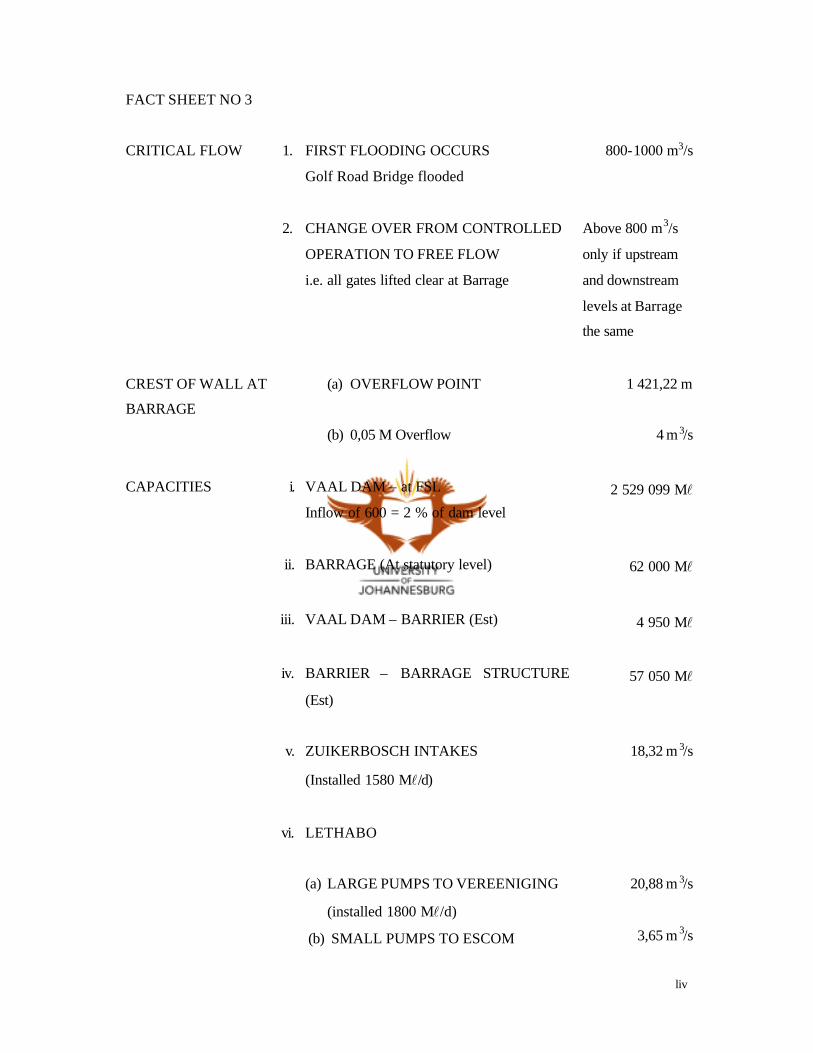
liv
FACT SHEET NO 3
CRITICAL FLOW 1. FIRST FLOODING OCCURS
Golf Road Bridge flooded
800-1000 m3/s
2. CHANGE OVER FROM CONTROLLED
OPERATION TO FREE FLOW
i.e. all gates lifted clear at Barrage
Above 800 m3/s
only if upstream
and downstream
levels at Barrage
the same
CREST OF WALL AT
BARRAGE
(a) OVERFLOW POINT 1 421,22 m
(b) 0,05 M Overflow 4 m3/s
CAPACITIES i. VAAL DAM – at FSL
Inflow of 600 = 2 % of dam level
2 529 099 Ml
ii. BARRAGE (At statutory level) 62 000 Ml
iii. VAAL DAM – BARRIER (Est) 4 950 Ml
iv. BARRIER – BARRAGE STRUCTURE
(Est)
57 050 Ml
v. ZUIKERBOSCH INTAKES
(Installed 1580 Ml/d)
18,32 m 3/s
vi. LETHABO
(a) LARGE PUMPS TO VEREENIGING
(installed 1800 Ml/d)
(b) SMALL PUMPS TO ESCOM
20,88 m 3/s
3,65 m 3/s

lv
(installed 315 Ml/d)
vii. (a) VEREENIGING NO 1 INTAKE
(b) VEREENIGING NO 2 INTAKE
(Installed No 1 777 Ml /d – No 2 498
Ml/d)
9,01 m 3/s
5,78 m 3/s
viii. BARRAGE (36 sluice gates all capable of
being lifted clear of the water)
Depending on
level upstream

lvi
FACT SHEET NO 4
CALCULATION OF RISE
OR FALL IN LEVEL
(Over 24 hours)
ix. (a) UPPER COMPARTMENT
1 Large Lethabo Pump
1 Small Lethabo Pump
0,17 m
0,04 m
(b) LOWER COMPARTMENT
1,7 m3/s Loss or Gain
0,01 m
CHANGE OVER OF
BARRAGE GATES
Each gate should be operated twice a year 25 out of 36
CALIBRATION OF
BARRAGE GATES
It is intended to calibrate two gates in the
centre
From 0 –
fully open
CLOSING OR OPENING
BARRAGE GATES
xi. Open from centre outwards SHUTTING
OUTWARDS from both sides to centre
N/A
xii. VEREENIGING PUMPING STATION
(Head Office to relinquish its control)
N/A
DELAYS IN RECEIVING
WATER FROM VAAL DAM
1. (a) UPPER COMPARTMENT
(Depending on Vaal Dam discharge
amount)
+- 12 hours
(b) LOWER COMPARTMENT
(Depending on level BEHIND barrier)
8 – 48 hours
DEPARTMENT OF WATER
AFFAIRS
2. (a) CONTROLS OUTFLOW OF
BARRAGE UNDER NORMAL
FLOW CONDITIONS
On demand
downstream
(b) NOTIFIES RWB OF FLOOD
RELEASES
N/A

lvii
DEMANDS 1. (a) UPPER COMPARTMENT 1,4 m 3/s
(excluding Lethabo pumps)
(b) LOWER COMPARTMENT 1,2 m 3/s
(Excluding RWB intakes)
INTAKE DEMANDS 2. ALL DEMANDS AT RWB INTAKES
SHOULD BE PASSED ON TO
BARRAGE
Variable

lviii
FACT SHEET NO 5
EFFLUENT 1. KLIP RIVER A STEADY FLOW OF 6,5 m3/s
EVAPORATION 2. IGNORE IN CONTROL 2 – 30 mm
per day
FLOW 3. FLOW OF THE BARRAGE
TRIBUTARIES ARE NOT READ
DAILY
Flow
depending on
rain
GATES 1. (a) SELECTION OF GATES AT THE
BARRAGE ARE INDICATED IN
SCHEDULE III
(b)THREE SLUICE GATES
MOUNTED IN THE BARAGE
WALL AT LETHABO (Each gate
5 m3/s)
15 m3/s
(c) 60 FLOOD GATES AT VAAL
DAM
(Depending on level)
60 – 100 m 3/s
each
HIGHEST LEVELS
RECORDED
1. (a) ZUIKERBOSCH INTAKE
(1975 Floods)
1 430,66 m
(b) VEREENIGING NO 1 INTAKE
(1975 Floods)
1 428,25 m
(c) BARRAGE
(1975 Floods)
1 422,43 m
HIGHEST INFLOW INTO
VAAL DAM
FEBRUARY 1975 2 798 m3/s
lix
FACT SHEET NO 6
LEVEL IN THE BARRAGE
(Operating range)
1. (a) “UPPER” COMPARTMENT ONLY 1,5 – 2,00 m
(b) “LOWER” COMPARTMENT ONLY
(Varied seasonally)
1st June – 31 August 7,3 – 7,55 m
1st September – 31st May 7,0 – 7,55 m
LEVEL AT ZUIKERBOSCH BELOW A STAFF READING OF 3,5 M
ADVERSE SUCTION CONDITIONS
Minimum
3,5 m at
Zuikerbosch
ORDERING OF WATER 1. BARRAGE CAN ORDER ALL WATER
FROM VAAL DAM
If it is
required to
maintain
level
RAINFALL (a) INFLOW FROM RAIN ONLY
INFLUENCES THE “LOWER”
COMPARTMENT
N/A
SPECIAL RELEASES (b) ALL SPECIAL RELEASES
BOAT RACES ETC WILL BE
DEALTH WITH BY HEAD
OFFICE
N/A

lx
PRE RELEASES AT THE
BARRAGE SHOULD NOT BE
DONE IN ANTICIPATION OF
INFLOW FROM RAIN
Operate on
increase of
flow only

lxi
CONTROL
From Schedule I the following can be deduced:-
1. That since the construction of the Barrier wall at Lethabo, the Barrage reservoir consists
of two compartments referred to as “Upper” and “Lower”.
2. That any water that might be required from Vaal Dam to control the level in the “Lower”
compartment must overflow the wall or be discharged from the sluice gates at the Barrier.
3. That there is no inflow from tributaries into the “Upper” compartment and all the polluted
water remains in the “Lower” compartment providing the sluice gates at the Barrier are
not opened.
4. That there are four intakes above the Barrier and thirteen intakes below.
5. That Zuikerbosch Pumping Station can draw raw water from four sources namely:-
a) Intakes
b) Vaal Dam – Zuikerbosch canal
c) Vaal Dam – Zuikerbosch pipeline
d) Lethabo
6. That Vereeniging also has four sources namely:-
1. Intakes No 1 and No 2
2. Lethabo
3. Ex Zuikerbosch
lxii
7. That detail of all raw water drawn from storage are not available to the Barrage staff, or
Vereeniging Pumping Station.
8. That the Vereeniging Pumping Station controls the pumping at Lethabo but Barra ge is
responsible for the releases from Vaal Dam. It should therefore be the duty of
Vereeniging Pumping Station to inform Barrage of all changes in pumping at both
Lethabo and Vereeniging.
lxiii
MAIN POINTS FOR BARRAGE TO OBSERVE BEFORE CONTROLLING THE LEVEL
1. Always work to a plan – think before you operate.
2. Convert any rise or fall in level to an expected twenty-four hour change i.e. change in six
hours multiplied by four.
3. Order water in good time taking into consideration that the “Upper” compartment has to
overflow first before Vaal Dam water reaches the “Lower” compartment.
4. Operate to the prescribed limits
“Upper” 1,5 – 2,00 m
“Lower” 7,0 – 7,55 m (Varied seasonally)
5. Operate the “Lower” compartment to the levels in Schedule II for flows 0 – 600 m3/s.
6. DO NOT PRE-RELEASE AT THE Barrage in anticipation of inflow from rain, operate
on a change of level only.
7. Stop all flow from Lethabo Barrier before spilling water from the Barrage. All releases
other than required by the Department of Water Affairs are defined as water spilled.
8. Selection of gate openings are given in Schedule III for flows 43 – 621 m 3/s.
9. Change over gates in operation once per week.

lxiv
METHOD OF CONTROL
DECISION-MAKING PLAN : TO BE USED FOR THE CONTROL OF BOTH
COMPARTMENTS
Answer the seven questions before adjusting the flow from Vaal Dam:-
1. Has there been any change in intake pumping?
2. What was the increase or decrease in level over the last twenty-four hours
providing that there was no previous change made during the period.
3. Has the outflow of the Barrage changed?
4. Is Vaal Dam meeting previous quantity ordered?
5. Are the “Upper” or “Lower” compartments at the required level?
6. What are the present weather conditions?
7. Is there an overflow at the Barrier?
APPLICATION
UPPER COMPARTMENT
Operating Range 1,5 m – 2,00
Overflow 2,22 m
1 ESCOM pump requires 1,4 m3/s
1 Vereeniging pump requires 5,8 m3/s
lxv
12 HOUR DELAY FOR CHANGE FROM VAAL DAM TO TAKE EFFECT DROP
IN LEVEL IN 24 HOURS:-
1 ESCOM pump 0,04 m
1 VEREENIGING pump 0,17 m
OTHER ABSTRACTION (EXCLUDING LETHABO) 1,4 m3/s.
WATER REQUIRED FROM VAAL DAM TO BALANCE LEVEL
1 ESCOM pump 1,4 m3/s
1 VEREENIGING pump 5,8 m3/s
OTHER 1,4 m3/s
_______
8,6 m3/s
The basic order for the above conditions is 8,6 m3/s.
It follows then that any change in pumping must be added or subtracted from
8,6 m3/s.
The level at present fluctuates because ESCOM are not running their pumps
continuously. To obviate this order an extra 1 m3/s when the level drops to 1,7 m
and allow level to build up slowly. Conversely cut the Dam by 2 m3/s when the
level reaches 1,90 m to avoid an overflow at the Barrage wall.
Barrage should be kept informed of all pump changes at Lethabo, and the Barrier
level (upstream) should be passed on to them twice a day.

lxvi
LOWER COMPARTMENT
Operating range:
1st June – 31st August 7,3 – 7,55 m
1st September – 31st May 7,0 – 7,55 m
(Measured at the Barrage cill)
Abstraction by:
Board a) Vereeniging Intakes
b) Zuikerbosch Intakes
Other 1,2 m3/s (estimated)
River staffs at:
a) Zuikerbosch
b) No 1 Intake Vereeniging
c) Barrage
The “Lower” compartment is controlled on the rise and fall in level recorded at the
Barrage staff.
An increase in level at Vereeniging will herald a similar rise four hours later at
Barrage. This acts as a pre-warning.
A check can be made to see if the “Lower” compartment is in balance by
converting all staff readings to MSL values. This is done by adding all staff
readings i.e. Zuikerbosch, Vereeniging and Barrage to the zero MSL values given
in the Fact Sheet section.
BASIC DIFFERENCE IS 0,01 m CHANGE IN LEVEL IN 24 HOURS = 1,7 m3/s

lxvii
Some examples:
a) Change in level
0,02 m in 24 hours 2 x 1,7 = 3,40 m3/s
0,03 m in 24 hours 3 x 1,7 = 5,10 m3/s
0,04 m in 24 hours 4 x 1,7 = 6,80 m3/s
0,05 m in 24 hours 5 x 1,7 = 8,50 m3/s
Adjustment in flow required to balance calculated as above.
CONVERTING PUMPING RATES TO m3/s
1 Ml = 0,0116 m3/s
Examples:
90 Ml/d x 0,0116 = 1,04 m3/s
100 Ml/d x 0,0116 = 1,16 m3/s
200 Ml/d x 0,0116 = 2,32 m3/s
300 Ml/d x 0,0116 = 3,48 m3/s
500 Ml/d x 0,0116 = 5,80 m3/s
It follows then that if a pumping change either at Zuikerbosch or Vereeniging of
500 Ml/d is made the level in the Barrage reservoir would fall by +- 0,03 m
assuming it was in balance to start with.
As all the inflow from the tributaries flows into the “Lower” compartment it will be
greatly influenced by rain in the Barrage catchment.
Rain at Zuikerbosch, Vereeniging and Barrage will influence the river level quickly
but usually with a short inflow characteristic.
Rain in Heidelberg/Springs area flow to the Barrage via the Suikerbosrand and
takes +- 3 days to reach the Barrage.

lxviii
The main inflow into the Barrage is via the Klip River. Rain at Zwartkopjes takes
one day while ra in south of Johannesburg takes +- 2 days. It must be remembered
that all Johannesburg sewage effluent is discharged into the Klip River, that is why
there is always a steady flow of approximately 6,5 m3/s.
In theory 25 mm of rain in the Barrage catchment area would produce a flow into
the Barrage of 56 m3/s; in practice this can only serve as a guide.
It is best not to make an allowance for anticipated run-off when operating. Control
on fact only i.e. once level rises.
The only time rain could be taken into consideration is when water is required from
Vaal Dam – ordering might be delayed on the knowledge of expected inflow.
CONTROL
Work to the same decision-making plan previously given.
But it will be realised that the control will vary for wet and dry weather conditions.
CONTROL FOR WET WEATHER CONDITIONS
In a good rain fall season it is found that the “Lower” compartment remains in a
state of fullness.
Counteract any supplies inflow by releasing excess from Barrage. The excess
water can be calculated as in the example above.
It is best to operate during heavy inflow periods below full say, 7,40 m to allow a
certain amount of buffer storage.
Allow level to creep back to 7,55 m once inflow has subsided.
lxix
The Board is obliged to utilise as much inflow water as possible according to an
agreement made with the Department of Water Affairs. Therefore intake pumping
at Zuikerbosch will be at a premium during high inflow periods. Conversely intake
pumps will not be run at Zuikerbosch during the dry winter months.
The Barrage can be operated under normal flow conditions for flows 0 – 600 m3/s
providing the levels set out in Schedule II are followed.
CONTROL FOR DRY WEATHER CONDITIONS
The basic difference in the method of control is that under these conditions it will
be necessary to order water from Vaal Dam to satisfy the pumps situated in the
“Lower” compartment. It must be remembered that water can only reach the
“Lower” compartment by overflowing the Barrier wall or opening the sluice gates
(maximum 15 m3/s). There could be delay of up to 48 hours depending on the level
upstream of the Barrier.
When levels in the “Lower” compartment reach 7,05 m it is best to order if a
minimum level of 7,00 is required and 7,30 m when a minimum of 7,25 m is
required (refer to seasonal level requirements).
Establish the balance point by using the decision making plan by comparing it with
the previous order.
Previous order based on:
Balance
Intake pumping 300 Ml /d or 3,5 m3/s 3,5 m3/s
Barrage outflow 7,6 m3/s 7,6 m3/s
Other 1,2 m3/s 1,2 m3/s
_______ ________
Order 12,3 m3/s 12,3 m3/s
Plus 1,7 m3/s
________

lxx
Level change - 0,01 m 14,0 m3/s
Although there was no change in abstraction by Vereeniging or Zuikerbosch one
ESCOM pump was put on at Lethabo.
The quantity of water ordered for the “Lower” compartment must include the
quantity required for Lethabo.
It is important that Barrage have knowledge of intake pumps on load at
Vereeniging and Zuikerbosch to operate successfully. This should be transmitted
at the same time as Lethabo information.
In conclusion Head Office will continue to act in an advisory capacity and will deal
with all special requests made by boating Clubs etc.
Guidelines of flood control will be drawn up at a future date.