appendix 4: case study 1 – discovery park - dover district … · · 2018-02-07case study 1 –...
TRANSCRIPT

Appendix 4: Case Study 1 – Discovery Park

Dover District Heritage Strategy
Case Study 1 – Discovery Park Enterprise Zone, Sandwich
Introduction
1.1 On August 16th 2011 the Government announced that the former Pfizer site to the north of Sandwich is to become an Enterprise Zone from 1st April 2012. Named as ‘Discovery Park’ the Enterprise Zone is intended to attract new companies to the site, creating new employment through a combination of simplified planning rules and business rate concessions. In addition funding was announced towards the improvement of flood protection for the site.
1.2 To achieve the simplified planning regime Dover District Council plans to develop a Local Development Order (LDO) which would enable the conversion of existing buildings, the development of new buildings and changes of use, without the need for individual planning permissions,
provided that it is within the scope of the Order. It is understood that the LDO will set out the parameters under which development can take place without seeking planning permission and will include guiding principles which development will take account of. The following case study sets out the archaeology and history of the site, the historic environment issues that arise with the development of the site (or parts of) and sets out a number of guiding principles to be taken into consideration in framing the Local Development Order.
1.3 This paper is based upon a rapid initial review of the assets from readily available sources such as the Kent Historic Environment Record, historic maps and the author’s familiarity with the area. More detailed assessment may identify additional issues and help to clarify those below.
The Site of the Discovery Park
1.4 The area initially proposed for the boundaries of the Discovery Park is shown in
Figure 1 Discovery Park Enterprise Zone (outlined red)
Cover Aerial View of Richborough Castle. © English Heritage
1

Figure 2 Wantsum Channel and Stonar Bank
estate including the companies A Bird and Eagle Sheds which are discussed further below. South still, the Discovery Park includes a large area of presently open space to Monk’s Way and then a further strip of open land between the road and the earthwork of Monk’s Wall.
Archaeological and Historical Background
1.5 The Discovery Park has potential to affect several of the themes set out in the Dover District Heritage Strategy (see Table 1.1).
1.6 The following is a summary of the archaeological and historical highlights of the area around the Discovery Park.
The formation of the Wantsum Sea Channel and Stonar Bank
1.7 The Discovery Park lies within an area that has seen considerable transformation over the last ten thousand years from a river
Figure 1. Sited on the former Pfizer site to the north of the historic town of Sandwich, the Enterprise Zone is 99.4 hectares in area. The site is bounded by the A256 Sandwich Bypass to the north-west, the former medieval sea wall known as the Monks Wall to the south-west, Stonar Lake to the south-east and the River Stour to the north-east. The site includes Ramsgate Road running northwards through the centre and the newly built Monk’s Way linking Ramsgate Road with the A256. To the west of Ramsgate Road can be found a complex of modern, state of the art buildings built by Pfizer in the last decade. Many of the buildings are up to 5 storeys high and are interspersed with areas of open space and car parking. The main car parking for Pfizer is found to the west and south of the buildings and is accessed off Monk’s Way. To the east of Ramsgate Road, the Pfizer site contains a mix of older and newer buildings including specialist manufacturing plant. To the south of the Pfizer site, the Discovery Park presently includes a small industrial / business
2

Dover District Heritage Strategy
Theme Principal asset(s) affected Type of potential impact
1 Coastal Landscapes & Processes Lydden Sea ValleyWantsum Sea Channel
Direct physical impact on sedimentary deposits
Monk’s Wall and associated drainage Direct physical impact, loss of coherent landscape feature and impact on setting
2.1 Medieval Ports of Sandwich & Stonar
Stonar Medieval Town Scheduled Monument
Low potential of impact on setting of Scheduled Monument
13 Conservation Areas Sandwich Conservation Area Potential impact on setting of Conservation Area
Richborough Scheduled Monument Impact on setting of the Scheduled Monument
11 Archaeology Roman, Saxon & medieval remains on Stonar Bank Ancient land surfaces, wrecks, marginal activities in alluvial depositsRemains of Richborough Port and associated army campsRemains of Stonar House
Direct physical impact on buried archaeological remains
10.3 Quarrying Stonar Quarry No impact likely
7.2 Courts & Manors Site of eighteenth century Stonar House
Direct physical impact on buried archaeological remains
4.1 Historic roads & lanes Ramsgate Road Potential impact on historic line of road
3.7 WWII Defences Richborough PortHaig CampKitchener Camp
Direct physical impact on standing buildings and buried archaeological remains
3.1 Roman Gateway Richborough Setting of the Scheduled Monument at Richborough
Sandwich Medieval Town Setting of the historic town and its heritage assets
3.6 Great War & Supply of the Western Front
Richborough PortHaig CampKitchener Camp
Direct physical impact on standing buildings and buried archaeological remains
5.2 Wrecks Medieval and earlier wrecks in the silts of the Wantsum Channel & Stonar Haven
Potential impact on remains of wrecks by below ground works
12 Built Heritage Remains of Great War buildings at Pfizer, A Bird and Eagle Sheds
Demolition and alteration of historic buildings
Table 1.1

valley in the chalk downs, to a sea channel known as the Wantsum, which following its silting was eventually reclaimed for grazing marsh and finally industrial and military development in the twentieth century.
1.8 The Wantsum Channel evolved from a river valley to become gradually submerged as sea levels rose through the Mesolithic. The natural marshland resources of the former Wantsum Channel provided an attractive resource for ancient peoples. A period of relatively dry conditions in the Neolithic and Bronze Age saw occupation sites established on these marginal lands before sea level rise in the Later Bronze Age saw the area inundated and the land surfaces submerged once more. Today, evidence of these former land surfaces, the contemporary environmental conditions and the prehistoric occupation of the area lies buried in well preserved peat deposits within the alluvium of the Wantsum Channel.
1.9 The Channel was a very important ancient navigational route which saw some of the great events in England’s history taking place there, for example the invasion of the Roman’s and the arrival of St Augustine’s mission. The Roman’s established a great port of entry into their new province at Richborough which sits at the south eastern end of the former Channel. At the south eastern mouth of the former Wantsum Channel, the Stonar Bank a shingle spit developed, probably through long shore drift. The formation of the Stonar Bank extends at least back into Roman times.
1.10 With the establishment of the Stonar Bank and another shingle spit building northwards from Deal in the mouth of the Wantsum, the channel became pent and the land behind the spits became a gradually filled with sediments to form mudflats and salt marsh. Within the alluvium of the former channel and marshlands can be found evidence of the maritime use of the channel
and the activities that took place to exploit the more marginal land such as salt working.
Richborough – the Roman Gateway
1.11 In AD 43 the Roman emperor Claudius ordered four legions and a similar number of auxiliaries under his general Aulus Plautius across the channel to begin the conquest of Britain. There is much debate about where the invasion force landed. Richborough (Roman RVTVPIAE) with the sheltered anchorage of the Wantsum Sea Channel is generally thought to be the location though alternative scenarios have proposed a site on the Solent. The case for Richborough as the prime site of the invasion is strong, though given the size of the force assembled multiple locations are possible. Factors in Richborough’s favour were the ease of the sea crossing from Gaul, the presence of the Wantsum anchorage, the subsequent development of a major entry port and its celebratory monument and the archaeological evidence. Excavations at the site have recorded a double ditch and bank of Claudian date, which is considered to be a beachhead defence.
1.12 Plautius and his legions marched inland to meet and defeat the British forces at a river crossing thought to be the Medway. The Britons were pushed back and pursued across the Thames before Claudius himself arrived for the final push on the Catuvellauni capital of CAMVLODVNVM (Colchester) and the surrender of the British in the south east.
1.13 The subsequent centuries, as Britain came mostly under Roman rule, saw the growth of Richborough (RVTVPIAE) and Dover (PORTVS DVBRIS) as the major ports of entry to the province at the coastal end of the Roman road network that extended into London (LONDINIVM) and the province.
1.14 Richborough, initially an important

Dover District Heritage Strategy
Figure 3 Plan of Monuments and buried archaeology at Richborough. © English Heritage
supply base for the conquest, saw the development of streets and timber buildings on the site of the early beachhead and the construction of a possible mansio, a hostel to provide bed and board to those on imperial business. A great monument, a quadrifons arch was constructed by Domitian around AD 85, probably to celebrate the conquest of the island by Agricola. Its construction coincided with a boom through the second century as stone buildings were constructed, roads re-laid and the port and its associated settlement (vicus) flourished.
1.15 The port declined in the third century possibly due to competition from other ports such as Dover. The military increased their presence and fortified the monumental arch, possibly taking advantage of its height as a look out. The monument was eventually levelled to make way for a Saxon Shore Fort built by the end of the third century and which continued into use as a base for the Legio II Augusta until their withdrawal to Gaul in AD 407. Coin evidence shows that Richborough was one of the last places in Britain to be supplied with Roman coinage and likely to have been the last bastion of
Roman administration in the province.
1.16 How early occupation occurred on the Stonar Bank has not been established. There is some evidence to suggest that by Roman times parts of the bank were stable enough to be used. Reports of a Roman wreck having been found in the nineteenth century east of Stonar Lake and of burials to the south of the lake suggest some usage, though these may be Saxon and slightly later.
Medieval
1.17 In medieval times, the southern end of the Stonar Bank was occupied by a flourishing port known as Stonar. The port which rivalled Sandwich survived to the fourteenth century when in 1365/6 it was inundated and then in 1385 burnt by a French force and largely destroyed. The historic medieval Cinque Port town of Sandwich lies to the south of the Discovery Park, separated by the Stour and the former marshlands reclaimed from the Channel.
1.18 The extending spits and the increasing marshland saw the gradual reclamation of the salt marshlands for freshwater pasture possibly as early as Roman times. By the medieval period, the manors of the area and the monastic houses of St Augustine’s and Christ Church in Canterbury were constructing large sea walls and draining the land behind in a process known as ‘inning’. Many of the sea walls and the drainage pattern created through this ‘inning’ are still distinctive in the landscape of the former Wantsum Channel today.
Richborough Port and the Supply of the Western Front
1.19 The gravel of the Stonar Bank became a much sought after resource for use in the massive construction of the naval harbour at Dover in 1898. The main contractor for the harbour works were S. Pearson & Son Ltd who constructed a mineral railway from the
3
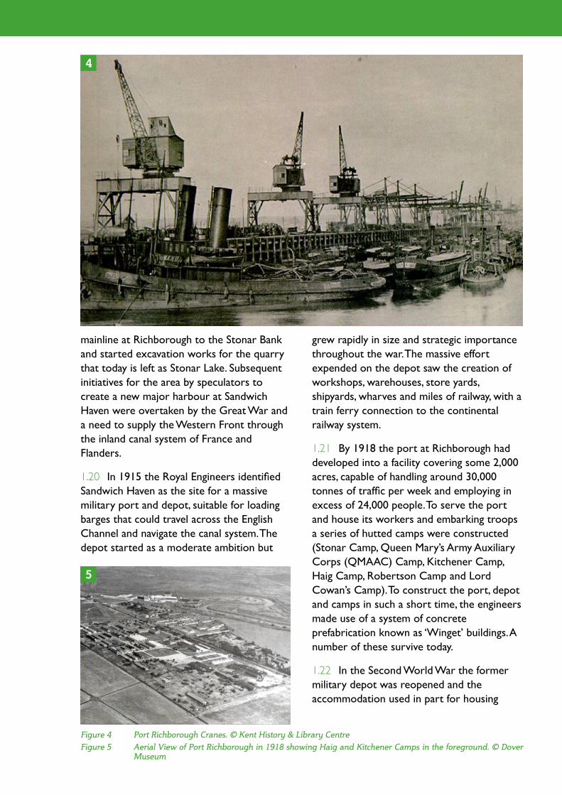
grew rapidly in size and strategic importance throughout the war. The massive effort expended on the depot saw the creation of workshops, warehouses, store yards, shipyards, wharves and miles of railway, with a train ferry connection to the continental railway system.
1.21 By 1918 the port at Richborough had developed into a facility covering some 2,000 acres, capable of handling around 30,000 tonnes of traffic per week and employing in excess of 24,000 people. To serve the port and house its workers and embarking troops a series of hutted camps were constructed (Stonar Camp, Queen Mary’s Army Auxiliary Corps (QMAAC) Camp, Kitchener Camp, Haig Camp, Robertson Camp and Lord Cowan’s Camp). To construct the port, depot and camps in such a short time, the engineers made use of a system of concrete prefabrication known as ‘Winget’ buildings. A number of these survive today.
1.22 In the Second World War the former military depot was reopened and the accommodation used in part for housing
mainline at Richborough to the Stonar Bank and started excavation works for the quarry that today is left as Stonar Lake. Subsequent initiatives for the area by speculators to create a new major harbour at Sandwich Haven were overtaken by the Great War and a need to supply the Western Front through the inland canal system of France and Flanders.
1.20 In 1915 the Royal Engineers identified Sandwich Haven as the site for a massive military port and depot, suitable for loading barges that could travel across the English Channel and navigate the canal system. The depot started as a moderate ambition but
4
5
Figure 4 Port Richborough Cranes. © Kent History & Library Centre
Figure 5 Aerial View of Port Richborough in 1918 showing Haig and Kitchener Camps in the foreground. © Dover Museum

Dover District Heritage Strategy
Jewish refugees from the continent.
Historic Environment Issues
1.23 Set out below are ten historic environment issues associated with the development of the Discovery Park Enterprise Zone.
1.24 Issue 1: There are sedimentary deposits of the Stonar Bank which are important for geoarchaeological studies.
1.25 As described above, the Discovery Park focuses on the former Stonar Bank shingle spit. Understanding its development and form is of considerable importance to understanding how the great Roman port of entry at Richborough operated and how the Wantsum Channel was navigated. New development which involves significant ground excavation, particularly in undisturbed locations could disturb sedimentary deposits of the Stonar Bank
1.26 Principle: Geoarchaeological investigation should accompany significant development proposals on the Stonar Shingle Bank.
1.27 Issue 2: Potential survival of archaeological remains of Roman, Saxon and Medieval date on the Stonar Bank around Stonar Lake.
1.28 Within the area of the Discovery Park the potential survival of occupation remains on the bank would have been severely compromised firstly by development of Richborough Port and then Pfizer. Areas fringing Stonar Lake may have slightly better potential. Development which involves ground excavation in areas that have not been previously disturbed by twentieth century development may encounter early remains.
1.29 Principle: Potentially archaeological evaluation and investigation needed in undisturbed areas of Stonar Bank prior to
development. Further appraisal of twentieth century impacts is needed to establish the extent of such areas.
1.30 Issue 3: Setting of the Scheduled Monument of Richborough.
1.31 The great Roman entry port of Richborough, the gateway to the province, lies on high ground to the west with views overlooking the Discovery Park. Part of the Roman port is managed as an important visitor attraction by English Heritage and is a Scheduled Monument. Although views across the Discovery Park are already affected by the development on the Pfizer west site, extending the built form of development to the west and towards the A256 bypass is likely to affect the setting of the monument and requires careful consideration of what scale and form of development may be appropriate in that area.
1.32 Principle: Development west of the Pfizer buildings should be of a scale and form that does not impact on the setting of the Scheduled Monument of Richborough.
1.33 Issue 4: Setting of the Scheduled Monument of Stonar Medieval Port.
1.34 The medieval port of Stonar today lies buried at the southern end of Stonar Lake, an important preserved example of a late fourteenth century town, and is protected as a Scheduled Monument. Although views across the length of Stonar Lake to the Discovery Park are likely to include potential development sites, the significance of the setting of the monument is unlikely to be affected.
1.35 Issue 5: Potential survival of former ancient land surfaces, wrecks and the remains of marginal activities on the former marshlands within the alluvial deposits on the west side of Ramsgate Road.
1.36 Within the Discovery Park, the land

west of Ramsgate Road is situated on the alluvium of the former Wantsum Channel which may have evidence of the former ancient land surfaces, ancient activities, wrecks and deposits of geoarchaeological and palaeo-environmental significance present. New development which involves below ground excavations or piling operations may impact on significant archaeological remains.
1.37 Principle: Potentially archaeological evaluation and investigation should accompany development with significant groundworks or piling works on areas of alluvium. Note that deposits are likely to be deeply buried and therefore the impacts of development will vary. Geoarchaeological investigation through boreholes may be appropriate in many cases.
1.38 Issue 6: The earthwork remains of the Monks Wall to the south west of the Discovery Park are an important historic environment asset that warrants protection and maintaining as a coherent and distinctive landscape feature.
1.39 Within the Discovery Park, inning of areas of the former marshland occurred on the western side of the Stonar Bank around the thirteenth century. A major sea wall, known as the Monk’s Wall was constructed by the cannons of St Augustine, Canterbury. Over eight metres in width and several metres high, the Monk’s Wall embankment formed a semi-circular enclosure to the west of what is now Ramsgate Road, enclosing the entire Pfizer western development site. Originally a substantial drainage ditch up to five metres wide ran inside the Monks Wall and further drainage ditches drained the ‘inned’ land. Today the wall survives as a substantial and well preserved earthwork monument to the south west of the recently built Monk’s Way road and at the boundary of the proposed Discovery Park. To the west the wall has been breached by the A256 and its northern elements have been completely lost under the Pfizer development. It has been suggested that the southern end of the Monks Wall forms the northern boundary of
Figure 6 Richborough Roman Port (A) and Stonar Medieval Port (B) Scheduled Monuments
6
A
B

Dover District Heritage Strategy
the town and development south of the road should be avoided.
1.44 Issue 8: The remains of Haig Camp and Kitchener Camp, important and rare surviving elements of the great First World War military port lie at the southern end of the Discovery Park.
1.45 The Discovery Park lies on a substantial part of the former military port. To the west of Ramsgate Road, were the accommodation barracks of the Kitchener Camp and the QMAAC Camps. Three buildings, large warehouses, in the A Bird property appear to survive from this camp.
1.46 On the east side of the road, the remains of part of the Haig Camp, possibly part of a military hospital block survive in the property presently occupied by Eagle Sheds between the Pfizer site and Stonar Lake. A residential property on the bank of Stonar Lake may have also been used as part of the military port. No specific survey has been
Stonar Haven where vessels using the medieval port would have beached.
1.40 Principle: New development should avoid encroaching to the south west of the Monk’s Way link road.
1.41 Issue 7: Setting of the historic town of Sandwich, its Monuments, Conservation Area and Listed Buildings.
1.42 The historic medieval Cinque Port town of Sandwich is celebrated and highly valued as one of the richest collections of historic buildings in the country, many of which are Listed. Its town walls are Scheduled Monuments and the town is a Conservation Area with additional protection afforded by Article 4 (2) Direction. The town is separated from the Discovery Park through open land and the River Stour
1.43 Principle: No development should be permitted that impacts on the setting of the historic town of Sandwich. The present link road acts as a buffer between the park and
Figure 7 The Monks Wall (both surviving earthwork and lost elements shown)
7

be assessed further.
1.48 Issue 9: The remains of Great War warehouses lie within the Pfizer site and relate to the history of the site and its use as a supply port.
1.49 Within the Pfizer site, the partial remains of two warehouses appear to have survived from the original military port and have been incorporated into the Pfizer use of the site. The condition and significance of these two warehouses has not been established but they also represent surviving remains of the military port. A more substantial warehouse building within the complex, highlighted by Butler in his account of Richborough Port as one of the first of the buildings constructed for the port in 1916 was demolished on the site within the last decade.
1.50 Principle: Further survey is needed to establish the condition and significance of the former military warehouses in the Pfizer site
undertaken of any of these buildings to record them or assess their significance but they appear to be an important group of former military buildings that represent some of the last remains of the great military port. The surviving buildings in the area south of Pfizer have been highlighted on the map below. The Eagle Sheds property is also the site of the former Stonar House, an eighteenth century residence.
1.47 Principle: The remains of the Haig Camp on the land between Pfizer and Stonar Lake should be considered to be an important collection of military buildings that relate back to the use of the area for the great military supply port of the First World War. Further survey is needed to establish their condition and significance however the buildings are worthy of retention and offer an opportunity to demonstrate an important part of the history of the area. Alteration of the buildings should be accompanied by survey and recording. Parts of Kitchener Camp on the west side of the road also survive and should
8
Figure 8 Great War buildings south of Pfizer

Dover District Heritage Strategy
and whether they are worthy of preservation, though given their apparent only partial survival this would seem unlikely on present evidence. If found to be significant then consideration should be given to uses that accommodate their future survival. Where demolition or conversion is accepted then a record of the structures should be made in advance of any change.
1.51 Issue 10: There may be additional remains of the former port and its use during both World Wars that survive, both as structures and as buried archaeology, but have not been identified. Post Medieval archaeology including the remains of the eighteenth century Stonar House may also be present.
1.52 The Discovery Park includes areas of the former Richborough Port and the Haig and Kitchener Camps, the site of eighteenth century Stonar House and the site of Pearson’s gravel quarry. Remains of structures and features connected with these aspects and in particular the port and camps may survive both in extant form and as buried archaeology. Archaeological remains may survive in these areas.
1.53 Principle: A walkover survey of the Discovery Park should be undertaken to identify any extant heritage features that may be worthy of retention or recording. Development should avoid damage or removal of any significant heritage features identified. Where it is accepted that demolition, removal or alteration of heritage features can take place, development should include a programme of recording prior to any works. Archaeological investigation may be required for development which involves ground excavation in areas of the former port, camps, or Stonar House.
Conclusion
1.54 A number of issues have been raised above that refer to the need in certain
development circumstances for archaeological and geoarchaeological survey, investigation and recording. In general a more detailed study including a walk over survey is needed to establish the parameters of what may survive in the Discovery Park and the locations of greatest sensitivity.
1.55 With respect to boundary discussions for the LDO, there would be a preference from the point of view of the heritage assets for the south western boundary to be the present A256 / Ramsgate Road link to protect the setting of the Monks Wall and keep it defined as a coherent earthwork monument in its surrounding open space. This would also help to maintain the setting of the historic town of Sandwich.
1.56 The boundary to the west of the Pfizer complex with the A256 would be acceptable provided that development parameters in the LDO are set that ensure that the setting of the Richborough Scheduled Monument is not harmed. Development in the area to the west of the present campus buildings should not be of a scale that dominates views from Richborough and of a quality that does not diminish present views.
1.57 The area of former Great War military buildings to the south of the discovery Park could be included within the LDO boundary but the development parameters again should be set to seek their retention and reuse rather than future demolition. These may provide an opportunity for future community use and a focus of interpretation of the military port.
1.58 The following is a list of the principles that should be considered for inclusion in the Local Development Order:
1: Geoarchaeological investigation should accompany significant development proposals on the Stonar Shingle Bank.
2: Potentially archaeological evaluation and

investigation needed in undisturbed areas of Stonar Bank prior to development. Further appraisal of 20th century impacts is needed to establish the extent of such areas.
3: Development west of the Pfizer buildings should be of a scale and form that does not impact on the setting of the Scheduled Mounument of Richborough.
4: Potentially archaeological evaluation and investigation should accompany development with significant groundworks or piling works on areas of alluvium. Note that deposits are likely to be deeply buried and therefore the impacts of development will vary. Geoarchaeological investigation through boreholes may be appropriate in many cases.
5: New development should avoid encroaching to the south west of the Monk’s Way link road.
6: No development should be permitted that impacts on the setting of the historic town of Sandwich. The present link road acts as a buffer between the park and the town and development south of the road should be avoided.
7: The remains of the Haig Camp on the land between Pfizer and Stonar Lake should be considered to be an important collection of military buildings that relate back to the use of the area for the great military supply port of the First World War. Further survey is needed to establish their condition and significance however the buildings are worthy of retention and offer an opportunity to demonstrate an important part of the history of the area. Alteration of the buildings should be accompanied by survey and recording. Parts of Kitchener Camp on the west side of the road also survive and should be assessed further.
8: Further survey is needed to establish the condition and significance of the former military warehouses in the Pfizer site and whether they are worthy of preservation though given their apparent only partial survival this would seem unlikely on present evidence. If found to be significant then consideration should be given to
uses that accommodate their future survival. Where demolition or conversion is accepted then a record of the structures should be made in advance of any change.
9: A walkover survey of the Discovery Park should be undertaken to identify any extant heritage features that may be worthy of retention or recording. Development should avoid damage or removal of any significant heritage features identified. Where it is accepted that demolition, removal or alteration of heritage features can take place, development should include a programme of recording prior to any works. Archaeological investigation may be required for development which involves ground excavation in areas of the former port, camps, or Stonar House.

Appendix 4: Case Study 2 – North Deal

Dover District Heritage Strategy
Case Study 2 – North Deal
Introduction
2.1 Dover District Council’s Core Strategy, which sets out the overall ambitions and priorities for the District, was adopted in February 2010. The strategy makes provision for 1,600 new homes in Deal in the period from 2006 to 2026 (Policy CP3) and also sets out a requirement for further investigation of Middle and North Deal to identify the capacity of the town to accommodate new growth beyond that set out in the Core Strategy (the Deal Study). The Deal Study considers a range of inter related issues and investigates opportunities for a range of new facilities including housing, community space, employment and open space. At present Stage 1 of the Deal Study has been completed which is a baseline understanding of Deal and issues such as flood, transport and access, ecology & environment, landscape and townscape have been investigated.
2.2 This North Deal Case Study is intended
to highlight the potential historic environment issues that may be faced by development in and to the north of Deal, identifying the key heritage assets that may be affected and sets out a number of guiding principles to be taken into account in future decision making for the area.
2.3 This paper is based upon an initial review of the assets from readily available sources such as the Kent Historic Environment Record, historic maps and the work carried out in the thematic studies for the Heritage Strategy. In addition a site visit of the area to the east of Sholden was undertaken by the author of this paper on 4th November 2011. The case study paper is not intended as a comprehensive account of the archaeology and history of the area and necessarily describes only those features most relevant to the potential development issues as presently known. More detailed assessment may identify additional issues and help to clarify those below.
Figure 1 The North Deal area of focus (outlined red)
Cover Historic drainage ditch in Lydden Valley near Sholden
1

The Study Area and principal proposals
2.4 For the purposes of this case study, the area being considered, i.e. the Study Area, is loosely formed as land to the north west of Deal, falling to the east of the A258, south of Fowlmead Farm and Redhouse Wall, west of Golf Road and north east of Middle Deal Road. It should be noted however that features outside of the area of focus may be affected adversely or beneficially by proposals within the Study Area and these are highlighted where recognised.
2.5 The main features of the Study Area as illustrated on the above map are:
• Fowlmead Country Park (and BMXtrack)– recently formed from the former waste heaps of the nearby Betteshanger Colliery;
• Cottington Court Farm, Kennels Farm, Sandfields Farm, Marsh Farm, Court Lodge
Farm, Churchfield Farm, Sholden Farm (nursery);
• Cottington Lakes;
• Sholden Village & Hull Place;
• Middle and Upper Deal residential areas (in part);
• Southwall Road Industrial Estate;
• Agricultural land & grazing marsh
• Embankments and drainage in the former marshland
• Deal to Sandwich mainline railway
• A258 road – main route between Deal and Sandwich
2.6 Within the Study Area a number of specific allocation sites and sites put forward for consideration have been briefly examined as part of the Heritage Strategy study (see Appendix 3). These sites are shown in Table 2.1
2
Figure 2 Specific allocations within the Study Area

Dover District Heritage Strategy
2.7 As can be seen above the allocations include two significant areas of new housing around Sholden which are the subject of current planning applications. The nature of the other potential development proposals is not fully understood but would include the expansion of the Southwall Road Industrial Estate into adjacent grazing and agricultural land and areas of infill development.
2.8 As well as the site specific proposals, mitigation of a number of significant issues is needed within the Study Area to accommodate future development proposals. The most significant issues are those of flood risk and traffic into Deal from the north.
2.9 The study area is very low lying, the majority being below 2 m. aOD and formed from the now reclaimed Lydden Sea Valley. Measures for sea defence works are under consideration on the sea frontage to the east of the study area with committed funding for Environment Agency works. Surface water
run off from new development sites may add to the risk of localised flooding within this area dependent on the capacity of the present system of drainage ditches and channels. Proposals for additional drainage channels and balancing ponds may come forward to mitigate the issue and take opportunities to increase wetland habitat.
2.10 Access to Deal from the north presently relies on the A258 through Sholden and through Upper Deal. Localised congestion is experienced at the junction of the A258 London Road and Manor Road, mainly at peak hours. Stage 2 of the Deal Study is investigating a range of access options to serve north and middle Deal area. There are, however, a number of limitations including NATURA 2000 sites, historic constraints, drainage patterns, the potential impact on the Fowlmead Country Park, the main rail line and the present settlement pattern.
Archaeological and Historical Background
2.11 The North Deal proposals have the potential to affect several of the themes set out in the Dover District Heritage Strategy (see Table 2.2).
2.12 The following is a summary of the archaeological and historical highlights of the area affected by the North Deal proposals.
The formation of the Lydden Sea Valley and Deal Spit
2.13 The majority of the Study Area lies on low lying land (below 2 m. aOD) of the Lydden Valley, an area that has been reclaimed since Roman times from inundation by the sea and salt marsh. The coastal processes involved in the formation of this area is considered in more detail in the Heritage Strategy (Theme 1 Coastal Processes and Landscapes) however in brief the sea valley was created as sea levels rose and breached
PHS010 Land Northwest of Sholden, Deal
Future Development Site
PHS009 Land Between Deal and Sholden
Future Development Site
NS04DEA South of Redhouse Wall
Call for Sites 2010
DEA09 Land r/o West Lea, Deal
SAD PO site 2008
DEA04 Land at Golf Road, Deal
SAD PO site 2008
NS07DEA Land between Albert Rd & Southwall Rd, Deal
Call for Sites 2010
DEA13 Minters Yard, Southwall Road, Deal
Future Employment Site
DEA22 Southwall Road, Deal SAD PO site 2008
Ref Site Type
Table 2.1

Theme Principal asset(s) affected Type of potential impact
1 Coastal Landscapes & Processes Lydden Sea Valley Direct physical impact on sedimentary deposits
2.2 Deal Port & The Downs Deal Historic Port Direct physical impact on sedimentary deposits
3.1 Roman Gateway Sholden Roman Villa Direct physical impact (possibly)
13 Conservation Areas Upper Deal Potential impact on setting of Conservation Area from junction works
12 Built Heritage Listed Buildings at Cottington, Hull Place
Potential low impact on setting of Listed Buildings
11 Archaeology Prehistoric, Roman, Saxon & medieval remains on high land fringing Lydden ValleyAncient land surfaces, geoarchaeological and palaeo-environmental deposits, wrecks, marginal activities in alluvial deposits of Lydden Sea ValleyRemains of Sholden Roman villaRemains of droveways, sea walls and drainage features of Lydden Valley – esp North Wall, South Wall, Marsh Wall
Direct physical impact on buried archaeological remains by development, infrastructure and drainage worksImpact on the setting of, and direct physical impact on historic landscape features of the Lydden Valley
10.1 East Kent Coalfields Betteshanger Colliery spoil heap & rail access
Potential low impact on line of rail access
7.2 Courts & Manors Site of Cottington Court
Hull Place
Impact on the setting of Hull Place and Cottington Court
6 Church Sholden Church Impact on the setting of Sholden Church
5.2 Wrecks Medieval and earlier wrecks in the silts of the Lydden Valley
Potential impact on remains of wrecks by below ground works
4.1 Historic roads & lanes Deal to Sandwich Turnpike Potential impact on historic line of road
3.7 WWII Defences Pillboxes and petroleum warfare Potential direct impact (location not established)
Historic Droves Droves may be directly impacted by development work, risk of loss as a coherent landscape feature and impact on setting; potential enhancement opportunities
St Leonard’s Church Reduced impact on setting of St Leonard’s Church
Listed Buildings and undesignated buildings of local interest in Upper Deal
Potential benefit from reduced traffic congestion on buildings in Upper Deal
Table 2.2

Dover District Heritage Strategy
the land bridge between Britain and the continent to form the channel about 8000 years ago. The former tributary valleys along the Kent coast became flooded and the area shown in blue on the figure above illustrates the possible extent of the inundation in the study area based upon geological observations.
2.14 Around 5,000 years ago a shingle spit developed northwards through the process of long shore drift from around Deal sheltering the land behind and forming the Lydden Sea Valley. By Roman times the spit had developed at least as far north as Sandwich Bay and to the north east of Sandwich by medieval times. Due to the growth of the spit the land behind became a muddy lagoon, gradually filling with sediments to form mudflats and salt marsh.
Reclamation of the Lydden Valley
2.15 The natural marshland resources of the Lydden Valley provided an attractive resource
for ancient peoples. A period of relatively dry conditions in the Neolithic and Bronze Age saw occupation sites established on these marginal lands before sea level rise in the Later Bronze Age saw the area inundated and the land surfaces submerged once more. Today, evidence of these former land surfaces, the contemporary environmental conditions and the prehistoric occupation of the area lies buried in well preserved peat deposits within the alluvium of the Lydden Valley.
2.16 The extending spits and the increasing marshland saw the gradual reclamation of the salt marshlands for freshwater pasture. From Roman times sea walls were constructed and drainage ditches excavated to reclaim more and more land. By the medieval period, the manors of the area and the monastic houses of St Augustine’s and Christ Church in Canterbury were constructing large sea walls and draining the land behind in a process known as ‘inning’. Many of the sea walls and the drainage pattern created through this ‘inning’ are still visible in the landscape of the
3
Figure 3 Lydden Sea Valley (extent of inundation in blue)
Lydden Valley.
2.17 The recent study by the Lydden Valley Research Group has examined the northward progression of the sea walls and drainage works from Deal to Sandwich. The earliest wall identified by the project, possibly Roman in its origins, is that which they have named The Lydden Wall running from Finglesham, east across the valley to meet the Deal Spit to the south of Dickson’s Corner. The Lydden Wall lies just to the north of Foulmead Farm outside of the Study Area. As the reclamation progressed northwards, further walls were built and have been charted by the Lydden Valley Research Group.
Archaeology
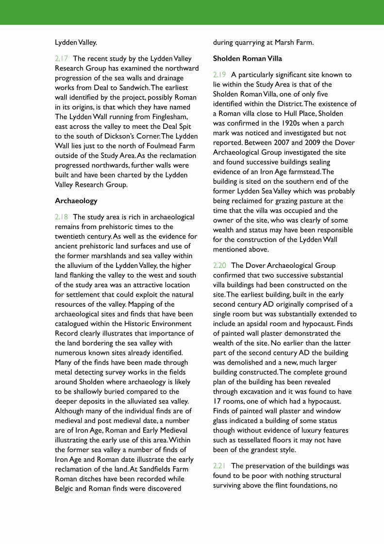
2.18 The study area is rich in archaeological remains from prehistoric times to the twentieth century. As well as the evidence for ancient prehistoric land surfaces and use of the former marshlands and sea valley within the alluvium of the Lydden Valley, the higher land flanking the valley to the west and south of the study area was an attractive location for settlement that could exploit the natural resources of the valley. Mapping of the archaeological sites and finds that have been catalogued within the Historic Environment Record clearly illustrates that importance of the land bordering the sea valley with numerous known sites already identified. Many of the finds have been made through metal detecting survey works in the fields around Sholden where archaeology is likely to be shallowly buried compared to the deeper deposits in the alluviated sea valley. Although many of the individual finds are of medieval and post medieval date, a number are of Iron Age, Roman and Early Medieval illustrating the early use of this area. Within the former sea valley a number of finds of Iron Age and Roman date illustrate the early reclamation of the land. At Sandfields Farm Roman ditches have been recorded while Belgic and Roman finds were discovered
during quarrying at Marsh Farm.
Sholden Roman Villa
2.19 A particularly significant site known to lie within the Study Area is that of the Sholden Roman Villa, one of only five identified within the District. The existence of a Roman villa close to Hull Place, Sholden was confirmed in the 1920s when a parch mark was noticed and investigated but not reported. Between 2007 and 2009 the Dover Archaeological Group investigated the site and found successive buildings sealing evidence of an Iron Age farmstead. The building is sited on the southern end of the former Lydden Sea Valley which was probably being reclaimed for grazing pasture at the time that the villa was occupied and the owner of the site, who was clearly of some wealth and status may have been responsible for the construction of the Lydden Wall mentioned above.
2.20 The Dover Archaeological Group confirmed that two successive substantial villa buildings had been constructed on the site. The earliest building, built in the early second century AD originally comprised of a single room but was substantially extended to include an apsidal room and hypocaust. Finds of painted wall plaster demonstrated the wealth of the site. No earlier than the latter part of the second century AD the building was demolished and a new, much larger building constructed. The complete ground plan of the building has been revealed through excavation and it was found to have 17 rooms, one of which had a hypocaust. Finds of painted wall plaster and window glass indicated a building of some status though without evidence of luxury features such as tessellated floors it may not have been of the grandest style.
2.21 The preservation of the buildings was found to be poor with nothing structural surviving above the flint foundations, no

Dover District Heritage Strategy
floors and evidence of robbing the later building in the twelfth to fourteenth centuries possibly for materials to be used in the construction of the parish church or the manor chapel at nearby Cottington. The building presently lies in a grassed field north of Hull Place which is used as a camping ground for touring caravans. Nothing has yet been found associated with the wider villa estate but there is good potential for additional buildings in the area around Hull Place and given the high water table in the area a high potential for waterlogged organic remains. The figure above shows the approximate location of the two buildings on the edge of the former sea valley.
Historic Droves
2.22 Within the Lydden Valley a system of droveways were constructed on earthen embankments from the surrounding highland into the grazing marsh. These droveways, often referred to as walls and named as such on historic and modern maps, allowed access
into the marshlands for livestock. They were often flanked by dykes either side for protection. First mentioned in a survey of 1347, the droves may in places extend back into Saxon and even Roman times. In all twenty one droveways have been identified in the Lydden Valley from documentary and map sources of which six fall within the Study Area. These are:
• Marsh Wall (now Marsh Lane)
• South Wall (partly Southwall Road)
• North Wall (partly Northwall Road)
• Redhouse Wall
• Cottington Wall
• Hull Wall
2.23 Of these six walls Marsh, South, North and Redhouse Walls are all readily visible in the landscape today while Cottington and Hull Walls have been lost beneath the
4
Figure 4 Location of Sholden Roman villa & edge of Lydden Valley alluvium

originally medieval with extensions of seventeenth and nineteenth century date, and a wall found to the south of the farm house which may be the ruined remains of the chapel. Speculation that Cottington was the site of a Deserted Medieval Village is probably unfounded.
2.25 Hull Place was built in the early eighteenth century as the seat of the Wyborn family and became the principle manor for Sholden. Several Listed Buildings fall within the grounds of Hull Place including the
Betteshanger spoil heaps and to the Cottington Lakes.
Cottington Court & Hull Place
2.24 Two notable residences within the study area are those of Cottington Court and Hull Place. Cottington Court Farm lies on the site of the medieval manor of Cotmanton which comprised a manor house with an attached chapel subject to the manor of St Augustine’s at Northbourne. The site presently consists of two Grade II Listed Buildings, the main farmhouse which is
5
Figure 5 Droves
Figure 6 Cottingham Court (1st edition OS map, 1862-1875)
Figure 7 Hull Place (1st edition OS map, 1862-1875)
6 7

Dover District Heritage Strategy
eighteenth century house, the Dower House and a stable block and coach house.
Sholden Church
2.26 The Parish Church of St Nicholas, Sholden dates back at least to the thirteenth century and possibly earlier as fabric of eleventh and twelfth century has been reported. It was originally a chapel, like that at Cotmanton subject to the manor of St Augustine’s at Northbourne. The church is Grade II* Listed Building with mainly thirteenth and fourteenth century fabric which was heavily restored in the late nineteenth century. The original door of the church was on its north side facing onto the original Deal to Sandwich Road that was replaced at the end of the eighteenth century by the new turnpike road which the present A258 follows. The church sits within a graveyard which was extended in the late nineteenth century into a plot on the west side of Church Lane and more recently into a field to the north of the church.
Upper Deal
2.27 During the medieval period Deal consisted of the village that is now known as Upper Deal about a mile from the present coast and centred upon the parish church of St Leonard which was probably founded around 1180. The settlement's relationship to the creeks and channels of the Wantsum Channel and the sea is unclear but its links to the sea are clear through one of the earliest
written references to Deal (that is Upper Deal) when in 1229 it was named as a limb of the Cinque Port of Sandwich. Little survives of the original village at Upper Deal apart from the church of St Leonard. The original road to Sandwich across the sand hills has since been deviated in part by the turnpike road. The area around the Grade II* church is designated as a Conservation Area which includes a number of Listed Buildings..
Historic Port of Deal
2.28 The development of the historic port of Deal is covered in detail as a theme in the Heritage Strategy (Appendix 1 Theme 2.2). In summary the present town was originally known as Lower Deal and grew following the establishment of the Henrician Device Forts (see Appendix 1 Theme 3.4) in 1539 to protect the important naval anchorage of The Downs. This stimulated the development of tenements along the storm gravel ridge north of Deal Castle and in the sea valley to the west of the ridge. The sixteenth century development was speculative and uncontrolled by the Archbishop who owned the land. By 1675 a formal pattern of three main streets was established (Beach Street parallel to the shore, Lower Street along the boundary of the manorial waste, and Middle Street) on the gravel ridge. The expansion of the town was extraordinary, by 1676 the population was over 1,000 and by 1699 around 3,000 at which time the town became incorporated.
8 9
Figure 8 St. Nicholas' Church, Sholden (1st editions OS map)
Figure 9 St. Nicholas' Church, Sholden (2nd editions OS map)

2.29 Deal became one of the most important naval centres in England from the middle of the seventeenth century until after the Napoleonic Wars. This was mainly due to its situation on the coast beside The Downs, where ships of all types, though mainly royal naval vessels anchored to escape bad weather and to acquire fresh supplies. Victuals were ferried to the ships by small boats launched from the shelving shingle beach, and there were never any harbour installations.
2.30 The eighteenth century was the town’s heyday, it thrived on war, firstly during the Seven Years War when it was regarded as one of the four great ports of England (Chatham, Portsmouth and Plymouth being the others) and then during the French and Napoleonic Wars (1793-1815). The town saw great expansion but had reached its peak by the end of the Napoleonic War and soon declined. By the end of the nineteenth century, Deal had attempted to establish itself as a seaside resort but never fully realised its ambitions as a successful resort town, not even when the railway reached it in 1847 and was extended to Dover in 1881. In the twentieth century the military and marine barracks on the outskirts of the town were influential in extending its built-up area into Walmer and Upper Deal. The establishment of the East Kent Coalfields influenced the expansion of the town in the pre-war years, particularly in the Mill Hill area to the west. By 1981 the census recorded a population of over 26,000 in Deal and Walmer. The barracks and coal mines were closed during the 1980s and 1990s with a resultant decline in the prosperity of the town and a decline in its population.
2.31 Deal is particularly rich with standing buildings in its extremely well preserved historic core, where eighteenth and nineteenth century houses predominate. The centre of the post-medieval town has been only slightly altered by modern development
and much of the area is today protected through Conservation Areas and its buildings through Listed Building status.
Betteshanger Colliery
2.32 Betteshanger Colliery was the biggest of Kent’s collieries and was founded by Pearson & Dorman Long who had bought up mineral rights to large areas of land in the Deal area in the hope of starting a considerable steel industry. They constructed a railway to their new mine from the main line just to the north of the Study Area and started to sink the first shaft in 1924. The flooding of the site was successfully kept under control by the cementation process and the sinking of the shafts progressed quickly, reaching coal by 1927. In a short space of time a large workforce of miners came to the area causing tensions with the local populous in the nearest town to the pit, Deal where many of them lived. Pithead baths were opened in 1934 to allow miners to return home reasonably clean. Deputies houses were constructed in an area close to the pit and in 1929 the farmland at Mill Hill, Deal was acquired to construct an estate for the Betteshanger miners. The colliery was the last in Kent and closed in 1989. The majority of the site has now been cleared save for one building, an office building, ahead of its regeneration by SEEDA. The former spoil tip which lies within the Study Area has been transformed into Fowlmead Country Park.
Roads and lanes
2.33 The first route through the Study Area is thought, on the basis of Roman and earlier finds, to be a track that ran through Upper Deal, Sholden, Cottington and Fowlmead towards Sandwich following the high ground on the edge of the marshes. The Roman Villa at Sholden was probably located to take advantage of this route and a possible tidal creek in the sea valley. Once the Deal Spit had extended far enough to connect with

Dover District Heritage Strategy
high ground at Sandwich, a new road between Deal and Sandwich was established along the coast. This coastal road was known as Downs Road or sometimes The Kings Highway or The Ancient Highway and is referred to as early as 1275. This became an important link between Deal and Sandwich until 1800 when a turnpike road was constructed between Dover and Sandwich through Deal. The new road ran to the west of the earlier track in the study area and presently forms the route of the A258. There were several toll gates along the route including one at Fowlmead. The disused chalk pit at Cottington provided chalk for the construction of the road.
Second World War Remains
2.34 The majority of the Second World War defences in the area were located on the coast to the north of Deal as a first line of defence against invasion. The Defence of Britain Project does record additional secondary defences close to Sholden Church including a petroleum warfare site and two
pillboxes. It is not known whether these features survive or their precise siting.
Historic Environment Designations
2.35 The above figure shows the location of Listed Buildings and Scheduled Monuments in the vicinity of the Study Area. The two Scheduled Monuments shown are the two Tudor Device Forts of Deal Castle and Sandown Castle. Neither fall within the study area.
2.36 The town of Deal has one of the largest collections of Listed Buildings in Kent, with over 300 focused on the historic core around Middle Street just to the west of the Study Area. Many of these Listed Buildings relate to the eighteenth and nineteenth century development of the town when it was at its heyday as an important port. A cluster of Listed Buildings can be found at the southern part of the Study Area in Upper Deal including the Grade II* St Leonard’s Church. A number of Grade II buildings flank Middle
10
Figure 10 Listed Buildings (blue) and Scheduled Monuments (purple shading) in the vicinity of the Study Area

Deal Road which once connected the original medieval village at Upper Deal with the new town of Lower Deal.
2.37 Other Listed Buildings can be found at St Nicholas’s Church and Sholden Hall in Sholden, at Hull Place and at Cottington Court Farm as described above.
2.38 A number of Conservation Areas lie close to the Study Area and one within it. The Conservation Area at Upper Deal focuses on the core of the historic village around St Leonard’s Church and includes the road
junction between London Road and Manor Lane which experiences significant traffic congestion at peak periods. To the east of the study area, a number of Conservation Areas focus on the historic town of Deal including the Middle Street Conservation Area which was the first Conservation Area designated in Kent (1968).
Historic Environment Issues
2.39 Set out below are nine historic environment issues that may be faced by development in the study area.
2.40 Issue 1: Potential survival of former ancient land surfaces, wrecks and the remains of marginal activities on the former marshlands within the alluvial deposits on the west side of Ramsgate Road. The alluvial deposits themselves may be important for geoarchaeological studies.
2.41 Large areas of the Study Area are the low lying former marshlands of the Lydden Sea Valley. The alluvium in these low lying areas may have evidence of the former
11
Figure 11 Conservation Areas in the vicinity of the Study Area
Figure 12 Setting of St Nicholas' Church, Sholden
12

Dover District Heritage Strategy
ancient land surfaces, ancient activities, wrecks and deposits of geoarchaeological and palaeo-environmental significance present. New development which involves below ground excavations or piling operations may impact on significant archaeological remains.
2.42 Principle: Potentially archaeological evaluation and investigation should accompany development with significant groundworks or piling works on areas of alluvium. Note that deposits are likely to be deeply buried and therefore the impacts of development will vary. Geoarchaeological investigation through boreholes may be appropriate in many cases.
2.43 Issue 2: High potential for archaeological remains of prehistoric, Roman, Saxon and Medieval date on the higher land surrounding the Lydden Sea Valley.
2.44 The Kent Historic Environment Record clearly illustrates the presence of a rich and important archaeological resource on the land around the Lydden Valley. While in places this may have been affected by development, especially Brickearth quarrying, much of the land has been undeveloped and archaeological remains are likely to be shallowly buried and vulnerable to most forms of new development.
2.45 Principle: Potentially archaeological evaluation and investigation needed in undisturbed areas of land prior to development.
2.46 Issue 3: Impact on Sholden Roman Villa.
2.47 The known remains of the Sholden Roman Villa lie within the camping field to the north of Hull Place . Roman remains have been found within Hull Place which may relate to the villa precinct and estate features are likely to occur in the surrounding land. The villa buildings are in a poor state of preservation, the latest and uppermost building having been robbed for construction
materials in the medieval period. Given the condition of the villa buildings the site is unlikely to meet the criteria required for designation as a Scheduled Monument. None the less, the villa is an important feature of the District’s Roman Gateway theme (Appendix 1 Theme 3.1) both in terms of the scarcity in the District of known villas (there are only five known) and also its location on the edge of the Lydden Valley and the part it potentially played in the reclamation of the valley. If development of the site of the villa comes forward then proposals should seek to preserve the villa buildings in their presently buried state. Archaeological evaluation of the wider site should be undertaken prior to an application for development of the site to establish whether any further remains of the villa are present that would warrant preservation. Given that the value of the villa mainly lies within its evidential value, it may be acceptable to preserve the buildings beneath development such as a road embankment.
2.48 Principle: Development of the site of the Sholden Roman Villa should seek to avoid direct impact on the known villa buildings and to limit damage to the villa's surrounding agricultural and industrial structures. Archaeological evaluation of the site is needed to inform decisions on development proposals for the area around the villa.
2.49 Issue 4: Impact on the medieval droves / walls and their setting.
2.50 A number of historic droves, dating at least back into the medieval times and possibly earlier, survive in the Study Area as embankments extending into the former grazing marsh of the Lydden Valley. Today the embankments are generally serving the same purpose of access into the valley though more for public footpaths and tracks than for the movement of livestock. Four droves in particular survive in good condition as coherent historic features within the

landscape: South Wall, North Wall (Northwall Road), Marsh Wall (Marsh Lane) and Redhouse Wall. These are marked by the embankments flanked on either side by drainage channels though in places the adjacent fields have risen to the extent that there is little difference in levels between the earthwork and the fields, particularly deeper into the Lydden Valley.
2.51 The main vulnerability of the Droves will be to direct impact on them from infrastructure such as road access and drainage channels crossing to serve new areas of development. While this may be impossible to avoid, consideration should be given to whether drainage can be culverted through the line of the droves so as to maintain the droveways as a coherent landscape feature. Should road access have to cross the droves then it should be designed to ensure that it as far as possible retains the coherence of the feature. The droves would benefit from a more detailed study to identify their best areas of preservation.
2.52 The Droves also provide an opportunity to be enhanced as features of the footpath network linking the new development around Sholden and North Deal with the Lydden Valley. Upgrading of footpaths on the walls, clearing of the ditches and some elements of interpretation focusing on the evolution of the Lydden Valley could add to the sense of place in this area.
2.53 Principle: Development should as far as possible seek to preserve and enhance the historic droveways in the Lydden Valley.
2.54 Issue 5: Setting of Listed Buildings at Cottington Court Farm and Hull Place.
2.55 The setting of the Grade II Listed Buildings at Cottington Court Farm and Hull Place may potentially be affected by increased traffic should a link road be established through fields between the two properties
and to the rear of Hull Place. The effects are likely to be only marginal given the potential separation of the Listed Buildings to the possible locations for new access. The Listed Buildings at Hull Place also lie close to the proposed new residential site to the south west.
2.56 Principle: Development in the vicinity of Cottington Court Farm and Hull Place should fully consider its impact on the setting of the Listed Buildings and include mitigation measures that minimise any impact on their setting.
2.57 Issue 6: Setting of St Nicholas’s Church, Sholden.
2.58 St Nicholas’s Church is presently set back from the main A258 Sandwich to Deal road, its main entrance being from the junction of Church Path (pedestrian only) and London Road to the south. A footpath flanks the south-west side of the church yard linking to Vicarage Lane and this is screened by trees on its south western side. The north-west boundary of the church yard (grave yard) is also heavily planted with a tree screen separating the churchyard with an area of undeveloped land. Brief examination of readily available sources has not found any evidence that the undeveloped land to the west of the church was once part of the graveyard and map evidence suggests that the graveyard extended onto land to the east of Church Path in the late nineteenth century.
2.59 Consideration is being given as to
13
Figure 13 Walking the Droves

Dover District Heritage Strategy
whether access could be created through the undeveloped land between the residential properties on Vicarage Lane and the Church. Such a road link could potentially affect the setting of the church which is a Grade II* Listed Building by introducing traffic through to the west side of the church. It may be possible to reduce the impact on the setting through reinforcement of the boundary screening on the west side of the church yard. Such screening would potentially need to sever the connection between the church and Vicarage Lane and would also reduce the glimpsed views of the west end of the church and its tower from London Road.
2.60 In creating access from London Road through the land to the west of the Church care would also need to be taken to ensure that junction works do not impact on the brick boundary wall of Sholden Hall which is part of the curtilage of the Grade II Listed Building.
2.61 Principle: Proposals to create new road access through land to the west of St Nicholas’s Church, Sholden should provide detailed analysis of potential impacts on the setting of St Nicholas Church and include measures to minimise any impact on the setting. Physical impact on the boundaries of the church and Sholden Hall should be avoided. If following analysis it is shown that a new access road would cause substantial harm to the Listed Building alternative routes should be considered.
2.62 Issue 7: Setting of the Conservation Area and Listed Buildings at Upper Deal including St Leonard’s Church.
2.63 The main road into Deal from the north runs through the Upper Deal Conservation Area which includes a number of Listed Buildings including the Grade II* St Leonard’s Church. The junction between London Road and Manor Lane within the Conservation Area has been identified as a
point of significant traffic congestion. Measures within the proposals for North Deal that reduce traffic congestion at this junction should have a positive effect on the setting of the Conservation Area and the Listed Buildings in Upper Deal. Improvement works at the junction need to be sensitive to the setting of the Conservation Area and Listed Buildings.
2.64 Principle: Measures to reduce traffic congestion within the Upper Deal Conservation Area will have a positive benefit to the setting of the Conservation Area and Listed Buildings. Junction improvements in the Conservation Area should be sympathetic to the setting of the Conservation Area and its Listed Buildings.
2.65 Issue 8: Impact on historic environment assets and their settings in the Study Area.
2.66 There is potential for a number of features connected with the Themes set out in the Heritage Strategy to fall within the Study Area. Remains of Second World War features are highlighted around Sholden, the rail access to Betteshanger Colliery and the historic roads connecting Deal with Sandwich may be affected by development proposals. Those proposing development should use the Themes set out in the Heritage Strategy as a starting point to understand the potential historic environment effects and opportunities of their proposals.
2.67 The effects (positive and negative) of development on the setting of both designated heritage assets (such as Listed Buildings, Conservation Areas and Scheduled Monuments) and undesignated assets such as historic buildings and structures that are not Listed buildings should also be considered at an early stage.
2.68 Principle: Proposals for development in the Study Area should use the themes set out in the Heritage Strategy as a basis to

understand potential effects and opportunities on the District’s heritage assets and their setting.
Conclusion
2.69 Sites that have been brought forward or proposed for inclusion in the Land Allocations Document have been assessed as part of the Heritage Strategy and are set out on the worksheet in Appendix 3. In summary those sites that fall within the study area were scored as follows (themes scoring 5 are not included):
2.70 The above table shows, as might be expected, that archaeology is a common issue with all the site proposals though it is only with the site PHS009 between Deal and Sholden that archaeology is judged as a constraining factor. In that case advice has been that evaluation of the development site should precede detailed design of the development and measures taken to avoid impact on features that warrant preservation in situ if they occur. Other sites will require archaeological measures in place with evaluation and investigation in advance of
4
SiteRef
PHS010
DEA13
3
3
3DEA22 4
443NS07DEA 3
3DEA04 3
3DEA09 3
443NS04DEA 3
4323PHS009 2
4
2
1 Co
asta
l Pro
cess
es
6 Ch
urch
7.2 C
ourt
s & m
anor
s
8 H
istor
ic Se
ttlem
ents
9 Fa
rmste
ads
10.3
Qua
rrying
11 A
rcha
eolo
gy
12.1
Liste
d Bu
ilding
s
4.2 R
ail

Appendix 4: Case Study 3 – Farthingloe

Dover District Heritage Strategy
several of the themes set out in the Dover District Heritage Strategy (see Table 3.1).
3.4 This case study is intended to provide an overview of the historical development of the site, to identify any key vulnerabilities and issues arising from possible development proposals as well as to identify any opportunities to enhance access, interpretation and enjoyment of the site’s heritage assets.
Site description
3.5 The Farthingloe site lies to the west of the town of Dover and adjacent to the fortifications of the Western Heights. The site lies to the south of the B2011 Folkestone Road and to the north of the A20. The site extends along a dry valley, one of a series that fed from the west into the Dour Valley. The Farthingloe site slopes up from the A20 to the ridgeline of Long Hill and back down to the south to the B2011. As such the site comprises three main components – the high ground of Long Hill, sloping valley sides and the valley bottom alongside the old Folkestone Road. The site is largely agricultural with areas of scrub, grassland, grazing pasture and some arable land. Although the site lies close to the urban centre of Dover, occupation within and immediately adjacent to the site is generally sparse, with a cluster of houses including Great Farthingloe Farm extending along the valley bottom.
3.6 To the north of the site, on the opposite side of the B2011 is Little Farthingloe (home to the Women’s Land Army Museum), beyond which the land raises up on the opposite side of the valley side to Coney Hill. To the south of the A20 is Round Down and Aycliffe and the site offers spectacular views from the Long Hill ridge of the western arm of Dover Harbour, the Channel and across to France. In total the
Case Study 3 – Farthingloe
Introduction
3.1 The site of Farthingloe lies to the west of Dover, adjacent to the fortifications of the Western Heights. The overall site comprises a number of components, namely a high ridge of land extending from the Western Heights, steeply sloping valley side and a strip of land along the valley base adjacent to the B2011 Folkestone Road (Fig. 1). The site is currently used for a number of purposes, including agricultural and includes the Great Farthingloe Farm. Great Farthingloe Farm itself is no longer in agricultural use and has most recently been used for office accommodation, whilst a barn adjacent to the farmhouse has most recently been used as a wedding venue.
3.2 The site is not identified in the Dover District LDF Core Strategy (adopted February 2010) but has been put forward as part of a development option for the LDF Land Allocation Document that also includes land within the Western Heights. The Farthingloe site has been put forward for a range of uses including housing, a country club, restaurant, care home and village centre on some 30 hectares together with a country park on a further 106 hectares of land. The proposed development at Farthingloe has been put forward in conjunction with a scheme for redevelopment at the adjacent site of the Western Heights. This case study concentrates on this Farthingloe part of the site. The site at Farthingloe lies within the Kent Downs Area of Outstanding Natural Beauty.
3.3 This case study has evolved from the site allocation impact assessment (Volume 1 Section 5.35 and Appendix 3) and draws on and develops information contained within the Theme Papers (Appendix 1). Proposed development at Farthingloe has been identified as having the potential to affect
Cover Farthingloe viewed from the Western Heights

site extends to some 155 hectares.
Historical background
3.7 The site lies on the south-western side of the River Dour, an area that has generally seen more limited development and subsequently has been the subject of limited systematic archaeological investigation. Nevertheless remains from the prehistoric period to the present day have been found within the wider landscape.
Pre-military remains
3.8 Within the vicinity of the proposed site finds of prehistoric date have largely been confined to chance find spots and there are no prehistoric remains recorded from within the site itself. Despite this it is still possible that presently unknown archaeological remains of the prehistoric period may survive on site, potentially masked by colluvium on the lower valley sides and valley bottom.
3.9 In the Romano-British period the line of the Roman road running from Folkestone
to Dover is projected to run close to the proposed site. The precise alignment of this route has not been confirmed, but it is generally believed to run just to the north of the site in question. Remains of Romano-British date have been found within the site close to Great Farthingloe Farm. These findings include a number of pits or ditches and perhaps indicate the location of a nearby farmstead. A Romano-British cemetery is recorded from Elms Vale, the neighbouring valley to the north, and it is possible that further cemeteries exist in the area.
3.10 It is likely that the Roman road remained a principal route into the early medieval period. Metal-detecting finds and other chance discoveries from the area have included an early medieval ring, two-early medieval brooches and an early medieval glass cup. The site’s location on a valley-side overlooking the valley bottom and close to the line of the route to Folkestone may have been a favourable location for early medieval burials. For the medieval period finds appear
1
Figure 1 The Farthingloe Study Site

Dover District Heritage Strategy
Theme Principal asset(s) affected
Vulnerabilities
3.5 Post medieval defences
Western Heights Setting of Western Heights, in views to and from the fortification. Setting of the Western Heights in long views from the AONB.
Citadel Battery Potential physical impact on the battery, as well as impact upon the setting of the battery.
3.7 WWII Defences Farthingloe HAA Battery
Low potential of impact on setting of Scheduled Monument
13 Conservation Areas Dover, Western Heights Conservation Area
Setting of Dover, Western Heights Conservation Area.
Undesignated military buildings
Potential physical and setting impacts on non-designated military buildings such as pillboxes.
11 Buried archaeology Pre-military and military buried remains
Direct physical impact on any buried remains.
9 Farmsteads Great Farthingloe Farm
Potential direct physical impact upon historic farmstead; impact upon setting of historic farmstead.
7.2 Courts & Manors Site of Farthingloe Manor
Potential physical impact upon buried remains associated with Farthingloe Manor.
Anti-invasion defences Potential direct physical impact on Second World War anti-invasion defences.
8 Historic Settlement Settlement pattern of Dover Town
Potential extension of the settlement along the Farthingloe valley bottom.
12 Built Heritage Great Farthingloe Farmhouse
Potential direct physical impact upon Listed Farmhouse; impact upon setting of Listed Farmhouse.
Opportunities
Potential planning gain arising from development at Farthingloe.Creating new links between Western Heights and Long Hill.
Potential to develop trails to and better present the battery site.
Potential to develop trails to and better present the battery site.
Creating new links between Western Heights and Long Hill.
Incorporate military buildings into new public park – enhancing, promoting and presenting military heritage of the site.
Potential to investigate, understand and promote the history of the site.
Promote beneficial long term public use for farmstead.Forms centrepiece to new development and help to create a sense of place.
Potential to explore and promote the history of the manor. Helps to create a sense of place.
Potential to develop trails to and better present the Second World War anti-invasion defences site.
Existing grain of settlement could be used to provide future development with a sense of place.
Promote beneficial long term public use for farmstead.Forms centrepiece to new development and help to create a sense of place.
Table 3.1

to be clustered around existing farms and hamlets and it is likely that the local settlement patter in the area had become established by this time. Hasted records that Great Farthingloe (previously Venson Dane) was historically possessed by the Cannons of St Martin’s. The site is recorded in Domesday and the manor of Farthingloe is recorded as remaining in the hands of St Martin’s Priory until the dissolution. Following the dissolution the manor was granted by the King to the Archbishop of Canterbury.
3.11 The First Edition Ordnance Survey Map shows the line of the Folkestone-Dover road as well as the sites of Little Farthingloe and Great Farthingloe. Great Farthingloe Farmhouse is Grade II Listed and the present building is understood to date to the early nineteenth century, but may incorporate earlier elements.
The Western Heights
3.12 In the post-medieval period military archaeological remains dominate the archaeological record for the area. In particular the Farthingloe site lies just to the west of the Scheduled Monument of the Western Heights. The first recorded permanent fortifications to be established on the Western Heights date to the late eighteenth century, erected in response to the American Wars, with the first works occurring in the late 1770s. The defences of this period comprised earthworks designed to protect infantry and artillery on the hill. These earthworks were unfinished and whilst nothing of this date is today visible buried remains could survive despite the later intensive military use of the site. These works do however mark the start of the fortification of the hilltop. In 1804 a plan was put forward to modernise the defences on the Western Heights. These new Napoleonic Period fortifications took the form of two major redoubts, the Citadel and Drop Redoubt, augmented with a series of
defensive lines and bastions. In this form the defences could hold a large body of men to repel any invading army as well as commanding the town, harbour and approach along the Folkestone Road. The fortification was designed to house a substantial body of men; both in purpose built barrack accommodation as well as in encampments as the need arose.
3.13 Advances in military technology coupled with a perceived threat of invasion in the mid-nineteenth century highlighted the need for the fortifications at the Western Heights to be upgraded. Following the Royal Commission Report on the nation’s fortifications a programme of upgrading was agreed. Further additions to expand and strengthen the existing Napoleonic Period fortifications were made, including provision of new Western Outworks, new barracks and a new entrance on the South Front. From 1867 advancement in artillery technology led
2
Figure 2 Aerial view of the Western Heights

Dover District Heritage Strategy
to a change in military thinking, from one focussed on fixed fortifications, to a mobile army employed in the field. The Western Heights’ role evolved to one of headquarters and supply site as well as acting as a site for high power artillery. With this changing role further modifications and additions were made to the fortification in the later nineteenth century. Additions of this period included four coastal batteries: the Citadel Battery (outside of the Western Outworks), South Front Battery (south of the Citadel), St Martin’s Battery (inside of the South Entrance) and North Lines Battery (west of the Drop Redoubt). Citadel Battery lies within the Farthingloe Case Study area.
Twentieth Century Defences
3.14 Whilst little is specifically known about the Farthingloe Site during the First World War, Dover remained a major defended garrison and naval port. The Citadel Battery
at the eastern end of Long Hill was in use during this period. In the Second World War Dover was a town on the front line and as such had a considerable military presence. As an officially designated Garrison, Dover was provided with extensive anti-invasion defences. Dover would have been vulnerable from invasion from the west, particularly if the neighbouring port town of Folkestone fell into enemy hands. A defensive perimeter was established to protect the western approaches to the town that extended from Crabble, through Elms Vale and the Farthingloe site, to the coast. At Farthingloe these defences included Pillboxes, slit trenches and barbed wire entanglements. The Folkestone Road running between Great and Little Farthingloe Farms was an obvious weak-point and additional defences to protect against enemy motorcades included roadblocks, minefields and anti-tank guns. Little visibly survives of these Second World
Figure 3 Citadel Battery
3

War defences in the very bottom of the valley; however there are extensive remains to the north of the road on Coney Hill as well as within the Farthingloe site on Long Hill.
3.15 Long Hill was also the location of two battery sites linked by a concrete military road. At the eastern end of the hill adjacent to the Citadel of the Western Heights is Citadel Battery. This battery was originally constructed between 1898 and 1900 to protect the town and port from bombardment by enemy ships and to control the Channel. The battery saw use during both the First and Second World Wars. By 1943 the battery was no longer required operationally and was placed under care and maintenance until being decommissioned in 1956. There are several Second World War defensive features surviving at the battery, including two pillboxes and a spigot mortar gun position. From Citadel Battery the concrete military road leads towards the Farthingloe (D1) Heavy Anti Aircraft Battery. The Farthingloe HAA battery comprises of four gun emplacements, which surround a
command gun post. Adjacent to the battery there are smaller machine gun emplacements, ancillary buildings, storage and magazine buildings, pillboxes and slit trench positions. Lying between the two batteries and accessed from the concrete military road there was a military camp and remains of buildings, hut bases, pillboxes and pathways belonging to the camp survive.
Statutory protection and designations
3.16 The fortification of the Western Heights is designated as a Scheduled Monument (list entry number 1020298). The scheduled area encompasses the entirety of the Western Heights fortification and extends into the Farthingloe case study to incorporate Citadel Battery. The valley bottom at Farthingloe is particularly visible from the Scheduled Monument. The Second World War defences on Long Hill and the Farthingloe Anti Aircraft Battery on Long Hill are not designated, but form an important group considered to be of potentially national importance. Protection of these assets through designation should be considered.
3.17 Great Farthingloe Farmhouse is a Grade II Listed Building (list entry number 1115131) and was first Listed in 1973. An
5
4
6
Figure 4 Military Road on Long Hill
Figure 5 & 6 Aerial view of Farthingloe HAA Battery in 1946 (5) and 2008 (6)

Dover District Heritage Strategy
informal farmyard is located to the rear (west) of Great Farthingloe Farmhouse, which includes a mixture of historic and modern farm buildings. The western side of the farmyard is defined by Great Farthingloe Barn which is curtilage Listed.
3.18 The Farthingloe site is located within the Kent Downs Area of Outstanding Natural Beauty (AONB) and sits in a prominent location within the AONB in views from the Western Heights. The eastern part of the site falls within the Western Heights Local Nature Reserve.
Vulnerabilities and Opportunities
Introduction
3.19 Heritage-led regeneration should play a key role in formulating any development proposals for the site. The historic environment has the potential to play a key role in creating and reinforcing a ‘sense of place’, adding character and distinctiveness to the Farthingloe site. The buildings, open spaces, historic features and patterns of roads, lanes and settlements are what ultimately define the character of a place. It is therefore important that any change is sensitive to this character, adding to and developing distinctiveness rather than diminishing it and creating uniformity or blandness.
3.20 At Farthingloe the historic environment can also be used to add less tangible benefits to any potential development. Developing and improving access into the historic landscape, through the use of heritage trails and the historic open spaces, can be used to draw communities out into the landscape in which they live, encouraging exercise and improving physical and mental health.
3.21 Heritage assets are however vulnerable to change and new development, such as that which is proposed for the site will potentially involve major change. Construction activities
could directly affect buried archaeological remains through the excavation of new foundations, services, remodelling of land, stripping of sites in advance of development, piling works and from the operation of plant. Development might also involve the demolition of or damage to historic structures, buildings or features. Development could also have a major effect on the setting of individual heritage assets as well as altering, or even completely changing, the overall character of the place. In any development proposal for the Farthingloe site consideration should be given to the sensitivity of individual assets, groups of assets and the place as a whole to change. This will require detailed assessment of the significance of an asset or place and an understanding of how development might affect this significance.
3.22 The following section presents a number of vulnerabilities and opportunities that arise when considering the historic environment assets present at the Farthingloe site. More detailed assessment may identify additional vulnerabilities and opportunities as well as to help to clarify those below. The intention of this section is to raise issues for discussion and further consideration and also to help inform emerging proposals for development at the Farthingloe site.
Opportunities arising from potential development proposals
3.23 1: Beneficial re-use of Great Farthingloe Farmhouse and associated historic farm buildings. Opportunity should be sought within any development proposal to secure a long-term use for Great Farthingloe Farm. This should ideally be focussed around a public or community use.
3.24 Great Farthingloe is an attractive and well proportioned Grade II Listed Building that should be retained as part of any development proposals. The farmhouse has

the potential to act as a focus for any development in the valley bottom, not only for the built layout of any future scheme, but also for the community who might live there. Re-use of the existing buildings will not only be economically beneficial, but will also ensure the long-term future of the historic farmstead. A use that allows community access would mean the historic asset positively benefits any future community at the Farthingloe site. A centrepiece role would be most appropriate, the farmhouse, for example, being used to house a doctor’s facility or the barn potentially being used as a community space or centre.
3.25 2: Improving access to the Long Hill Military assets through the creation of a country park. The military heritage assets on Long Hill will add value to any proposal for a country park.
3.26 Dover has an exceptional collection of historic fortifications, including the Castle Western Heights and Fort Burgoyne. Alongside these fortifications there survive extensive militarised landscapes to the east and west of the town, which include numerous military remains, particularly of Second World War date. The ephemeral and sometimes disjointed nature of such remains means that it is sometimes difficult to articulate and understand them on the ground. At Farthingloe however the relatively unchanged nature of the landscape since the Second World War, the well-preserved nature of the remains and the survival of features such as the military concrete road mean that it is easier to explore and understand the remains as a group.
3.27 The military remains would add significant value to any country park; they could act as a focus for engaging and drawing people out into the landscape, encouraging people to explore the heritage and the wider landscape in general. Such military remains are generating increased public interest and
would provide a visible and engaging link to the site’s past for visitors and locals alike as well as being an important educational resource. An increase in appreciation, understanding and management of the heritage assets arising from the creation of a country park would help to secure the assets and potentially reduce vandalism and anti-social behaviour that presently affects some.
3.28 3. Creating links between Farthingloe and adjacent historic sites and the wider landscape. The military remains at Long Hill are part of a network of military sites across the wider area. The potential country park could act as a hub to promote links to other nearby heritage assets and landscapes.
3.29 The fortifications surviving along Long Hill are located on public access land and are a short walk from the Western Heights. Two major walking routes, in the form of the Saxon Shore Way and the North Downs Way pass close to the Farthingloe site. As such Farthingloe presents an ideal opportunity to promote access to and exploration of the District’s military heritage. New footpaths, bridleways and accessible trails could be established to allow the various assets to be linked and explored. Access, interpretation and presentation of, the sites Second World War heritage assets could for example form one focus for trails linking to the Western Heights and provide an introduction to the areas Second World War military heritage. Longer distance walks from the site could also connect to other contemporary remains, both further along the coast towards Folkestone and on the northern side of the valley at Coney Hill.
3.30 4. Development at Farthingloe could provide a planning gain to benefit other heritage assets. Should an acceptable development be achieved at Farthingloe this could be used to bring positive benefits to other nearby heritage assets, such as at the Western

Dover District Heritage Strategy
Heights.
3.31 There are a number of significant heritage assets close to the Farthingloe site for which there are no long-term uses and/or significant management issues. If acceptable development can be achieved at Farthingloe this could present an opportunity to provide resources so as to bring a positive gain to currently under-used or neglected heritage assets. The Scheduled Monument of the Western Heights, for example, is currently identified on English Heritage’s Heritage at Risk register. The Western Heights fortifications are identified as being as one of English Heritage’s top-ten priority sites of those listed in register for the south-east. A planning gain from Farthingloe has the potential to positively contribute to securing a long-term future for the monument. Any such decision would need particularly careful consideration in order to balance potential harm against potential benefit. As such any proposal would need to precisely define overall harm and benefit as well as being entirely transparent. As the Farthingloe site lies within an AONB any benefit to the historic environment would need to justified against and balanced with potential impacts on the natural landscape and environment.
Vulnerabilities arising from potential development proposals
3.32 1: The site is located in a landscape that is generally rich in archaeological
remains from the prehistoric period onwards. Archaeological investigation should accompany any proposals for the redevelopment of the site.
3.33 The Farthingloe site lies on the western side of Dover and comprises high ground along Long Hill, one side of a steeply sided valley and part of the valley bottom. Settlement remains for all periods are perhaps most likely to have been located on or close to the valley bottom. The steep sides of the valley are unlikely to have been intensively used. Much of the ridge of Long Hill is now used for agriculture and it is likely that this pattern was the same historically. The high ridge may have acted as a focus for ceremonial monuments in the late prehistoric period, with Bronze Age barrows being a common feature of such downland areas to the east of the Dour. Chance finds from the area suggests some potential for Anglo-Saxon cemeteries on the higher ground flanking the line of the Roman Road.
3.34 There has been limited investigation within the site itself and in the wider area generally, however those investigations that have taken place within the site have exposed buried archaeological remains, whilst chance finds of prehistoric to medieval date have been made nearby. In 1919 Roman pottery was recorded as coming from the Farthingloe area, whilst in 1987 an archaeological evaluation ahead of the construction of a Channel Tunnel construction workers compound found evidence for Romano-British occupation. These findings include a number of pits or ditches and perhaps indicate the location of a nearby farmstead. The terraces for this compound along with access roads still survive close to Great Farthingloe Farm. This terracing is likely to have locally removed or severely impacted upon buried archaeology, but elsewhere along the valley bottom archaeological remains will potentially survive, perhaps capped by colluvial deposits. In the immediate vicinity of
7
Figure 7 View from the Western Heights towards Great Fathingloe Farm

Great Farthingloe Farmhouse there may be surviving archaeological remains associated with the medieval manor.
3.35 2: The setting of Great Farthingloe Farm. Development proposals should not cause adverse harm to the setting of Great Farthingloe Farmhouse.
3.36 Great Farthingloe Farmhouse is a Grade II Listed Building. The Listing describes the farmhouse as an early nineteenth century building of three storeys, although it has been suggested that the structure may incorporate earlier elements. The front elevation of the farmhouse faces east towards Dover and features bay windows on the ground floor with a central doorway up a short flight of stairs. Development at or close to the Grade II Listed Farmhouse has the potential to adversely affect the buildings setting. Any proposals for the development in the immediate vicinity of the Listed Farmhouse should seek to protect and enhance the immediate setting of the building.
3.37 3: Great Farthingloe Farm and associated historic farm buildings should be retained in any redevelopment scheme for the site. Development in the immediate vicinity of the farm should be sympathetic to the
character of the place. Any conversion or alteration works to the farmhouse or historic farm buildings should be accompanied with and informed by historic building recording.
3.38 Great Farthingloe Farmhouse is a Grade II Listed Building. The Listing describes the farmhouse as an early nineteenth century building of three storeys. The front elevation of the farmhouse faces east towards Dover and features bay windows on the ground floor with a central doorway up a short flight of stairs. It has been suggested that the structure includes earlier brickwork and incorporates a section of earlier chalk block walls.
3.39 The surviving farm complex includes some historic outbuildings including a thatched barn. Historic mapping shows further additional ranges of buildings that have been subsequently demolished. The historic farmhouse and associated historic farm buildings should be retained as part of any development proposal for the site. Where development involves the adaptation or conversion of the historic buildings this should be accompanied and informed by a programme of historic building analysis and recording to appropriate professional
8
Figure 8 Aerial view of the Farthingloe site

Dover District Heritage Strategy
standards.
3.40 The recommendations set out in the Kent Farmsteads Guidance should be used to inform any development within or immediately adjacent to the core of the historic farmstead.
3.41 4: The setting of the Scheduled Monument of the Western Heights. The site at Farthingloe is located immediately to the west of the Scheduled Monument of the Western Heights. Careful consideration needs to be given to what scale and form of development may be appropriate so as to avoid harm to the fortification’s setting.
3.42 The Western Heights sit on a dominant position on high ground on the western side of the town of Dover. The fortification overlooks and was designed in part to dominate the approach from the west along the Folkestone Road. The fortification is visible on the skyline when approaching Dover from the west, whilst the site of Farthingloe is clearly visible in views out from the Western Heights, especially when looking out along the old Folkestone road. The present settlement pattern supports the impression that the Western Heights lies on the edge of and guards the western approaches to Dover. Whilst there is settlement in the valley bottom to the north of the fortification, the landscape to the west is only lightly occupied and is largely represented by agricultural- and down- land with only small scale settlement in the valley bottom at Farthingloe. As such the current landscape outlook that the Kent Downs AONB provides helps to reinforce setting of the fortification. Any development within the valley bottom therefore has the potential to affect the setting of the Western Heights, both in views out from the fortification and in vies of the fortification from the AONB and the old Folkestone Road.
3.43 The setting of the Western Heights is
important in understanding how the fortification functioned and how it was designed to dominate and control the approaches to the town from the west. The historic character has traditionally been one where the fortification lies on the edge of the urban confines of Dover with only small scale ‘rural character’ settlement extending beyond the fortification. Substantial development in the valley bottom at Farthingloe would be a major change to this historic character. It is important therefore to understand in detail the significance of the Monument, how development could affect this significance and whether development would be detrimental to the understanding of the Monument. The degree of harm would need to be assessed on a case by case base depending on the precise development proposals being brought forward. English Heritage has produced a methodology for assessing heritage significance within views (Seeing the History in the View, 2011) and managing change within the setting of heritage assets (The Setting of Heritage Assets, 2011) and these should be used as a basis for assessing the harm caused by potential development at Farthingloe on the setting of the Western Heights.
3.44 5: The need to protect the important military remains on Long Hill. The military remains on Long Hill are of considerable significance, but are currently at risk from neglect, decay and vandalism. A sustainable and long-term future should be sought for the Long Hill military remains. The majority of the military remains are not currently designated, but would warrant protection, enhancement and interpretation as part of any future proposals.
3.45 Dover contains a nationally, if not internationally important collection of historic fortifications. The Farthingloe site includes the remains of Citadel Coastal Battery, constructed in the late nineteenth and designated as part of the Western

Heights Scheduled Monument. To the west of Citadel Battery along the ridge of Long Hill there is an important group of Second World War remains. These remains include numerous anti-invasion defences as well as a well-preserved Heavy Anti Aircraft Battery and associated accommodation camp.
3.46 The downland landscape to the west of the town is little changed since the Second World War and as such the military landscape that survives can be readily understood alongside the defensive considerations that led to its creation. The nature of the Second World War remains means that they are vulnerable to neglect, decay and vandalism as well as to demolitions and clearance. The military landscape at Farthingloe was surveyed in 1995, but since that time a number of features including pillboxes have been cleared and demolished. Options to prevent further loss and to protect and enhance the surviving remains should be sought as should ways to reduce vandalism at these sites.
Recommendations
Archaeological investigation should accompany any proposals for the redevelopment of the site.
Development should seek to preserve any significant archaeological remains at the site.
New development should not adversely harm the setting of the Scheduled Monument of
the Western Heights.
Development should not adversely affect the setting of Great Farthingloe Farmhouse, a Grade II Listed Building and should be sympathetic to the historic farmstead.
Any changes and alterations to historic buildings and structures should be accompanied by and informed by a programme of historic building recording
New development should respond and be sympathetic to the historic character of the site.
Key development principles
• Use the historic character of the place to inform future development and create a sense of place
• Interpret, enhance and celebrate the significant military remains at Farthingloe. Opportunities to protect the most significant assets should be secured
• Create new links between the valley bottom and Long Hill to encourage people to explore and appreciate the site’s military heritage
• Promote Long Hill site as part of a wider military landscape and provide links to other nearby heritage assets
• Use Great Farthingloe Farmhouse to form a focal point for new development
• Promote a beneficial long term public use for Great Farthingloe Farmhouse and Historic Barn
9
Figure 9 Farthingloe WW2 Heavy Anti-Aircraft Battery

Appendix 4: Case Study 4 – Fort Burgoyne and Connaught Barracks
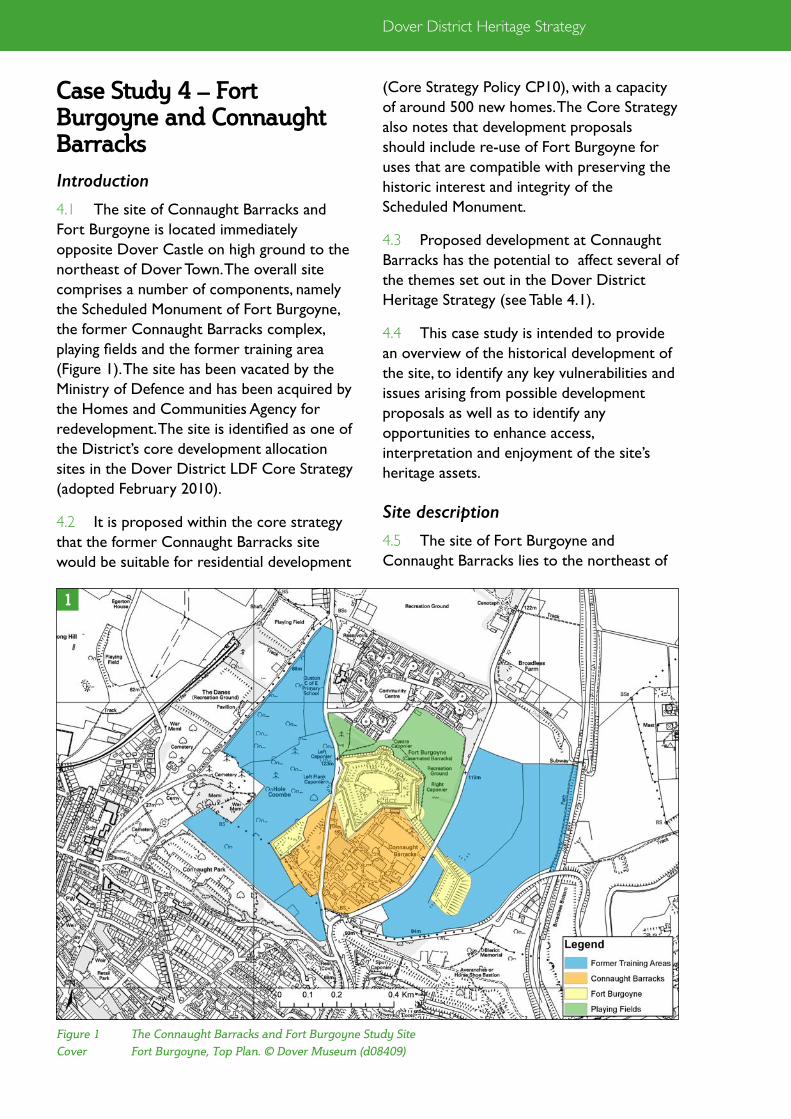
Dover District Heritage Strategy
(Core Strategy Policy CP10), with a capacity of around 500 new homes. The Core Strategy also notes that development proposals should include re-use of Fort Burgoyne for uses that are compatible with preserving the historic interest and integrity of the Scheduled Monument.
4.3 Proposed development at Connaught Barracks has the potential to affect several of the themes set out in the Dover District Heritage Strategy (see Table 4.1).
4.4 This case study is intended to provide an overview of the historical development of the site, to identify any key vulnerabilities and issues arising from possible development proposals as well as to identify any opportunities to enhance access, interpretation and enjoyment of the site’s heritage assets.
Site description
4.5 The site of Fort Burgoyne and Connaught Barracks lies to the northeast of
Case Study 4 – Fort Burgoyne and Connaught Barracks
Introduction
4.1 The site of Connaught Barracks and Fort Burgoyne is located immediately opposite Dover Castle on high ground to the northeast of Dover Town. The overall site comprises a number of components, namely the Scheduled Monument of Fort Burgoyne, the former Connaught Barracks complex, playing fields and the former training area (Figure 1). The site has been vacated by the Ministry of Defence and has been acquired by the Homes and Communities Agency for redevelopment. The site is identified as one of the District’s core development allocation sites in the Dover District LDF Core Strategy (adopted February 2010).
4.2 It is proposed within the core strategy that the former Connaught Barracks site would be suitable for residential development
Figure 1 The Connaught Barracks and Fort Burgoyne Study Site
Cover Fort Burgoyne, Top Plan. © Dover Museum (d08409)
1
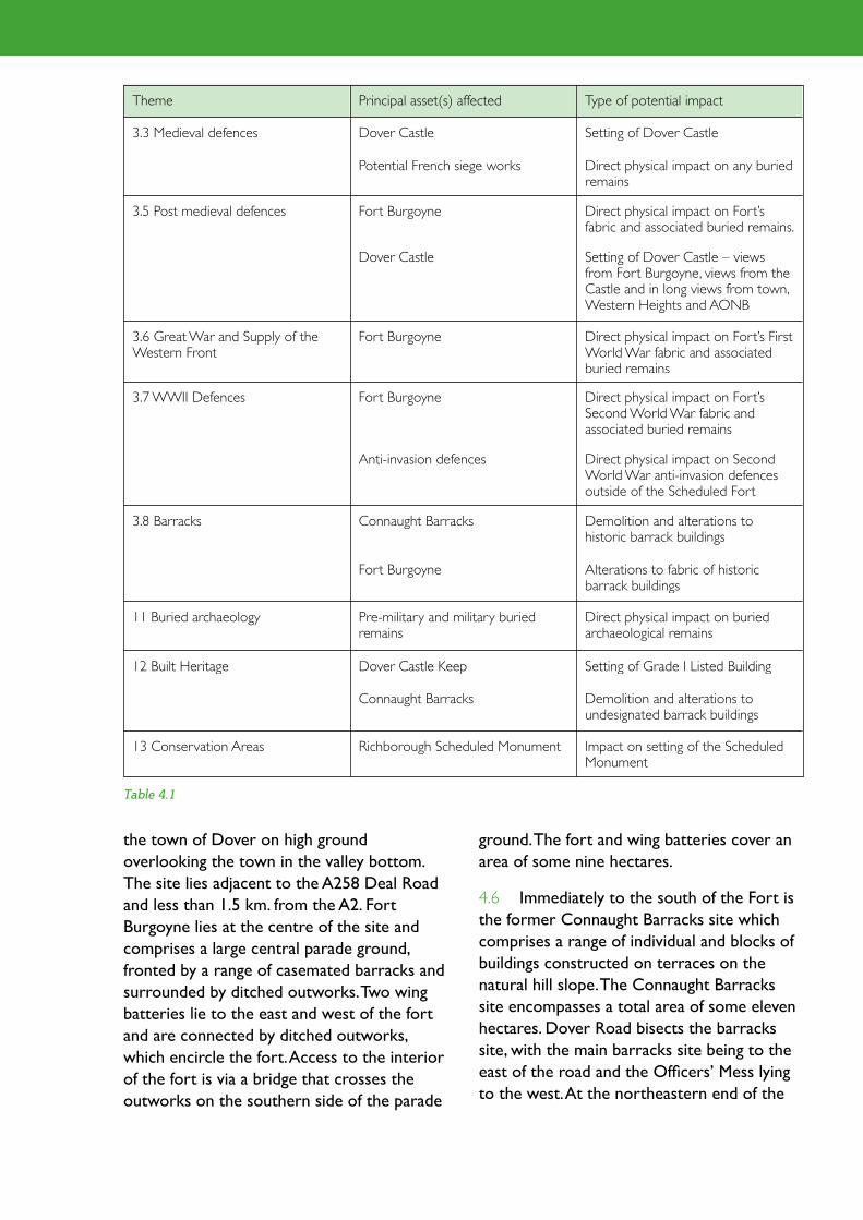
Theme Principal asset(s) affected Type of potential impact
3.3 Medieval defences Dover Castle Setting of Dover Castle
Potential French siege works Direct physical impact on any buried remains
3.5 Post medieval defences Fort Burgoyne Direct physical impact on Fort’s fabric and associated buried remains.
13 Conservation Areas Richborough Scheduled Monument Impact on setting of the Scheduled Monument
Connaught Barracks Demolition and alterations to undesignated barrack buildings
12 Built Heritage Dover Castle Keep Setting of Grade I Listed Building
11 Buried archaeology Pre-military and military buried remains
Direct physical impact on buried archaeological remains
3.8 Barracks Connaught Barracks Demolition and alterations to historic barrack buildings
Anti-invasion defences Direct physical impact on Second World War anti-invasion defences outside of the Scheduled Fort
3.6 Great War and Supply of the Western Front
Fort Burgoyne Direct physical impact on Fort’s First World War fabric and associated buried remains
Dover Castle Setting of Dover Castle – views from Fort Burgoyne, views from the Castle and in long views from town, Western Heights and AONB
3.7 WWII Defences Fort Burgoyne Direct physical impact on Fort’s Second World War fabric and associated buried remains
Fort Burgoyne Alterations to fabric of historic barrack buildings
Table 4.1
the town of Dover on high ground overlooking the town in the valley bottom. The site lies adjacent to the A258 Deal Road and less than 1.5 km. from the A2. Fort Burgoyne lies at the centre of the site and comprises a large central parade ground, fronted by a range of casemated barracks and surrounded by ditched outworks. Two wing batteries lie to the east and west of the fort and are connected by ditched outworks, which encircle the fort. Access to the interior of the fort is via a bridge that crosses the outworks on the southern side of the parade
ground. The fort and wing batteries cover an area of some nine hectares.
4.6 Immediately to the south of the Fort is the former Connaught Barracks site which comprises a range of individual and blocks of buildings constructed on terraces on the natural hill slope. The Connaught Barracks site encompasses a total area of some eleven hectares. Dover Road bisects the barracks site, with the main barracks site being to the east of the road and the Officers’ Mess lying to the west. At the northeastern end of the
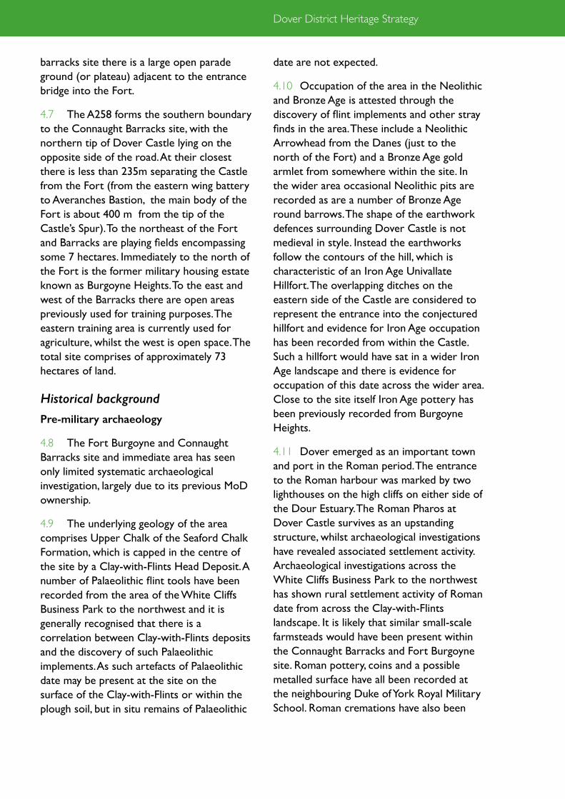
Dover District Heritage Strategy
barracks site there is a large open parade ground (or plateau) adjacent to the entrance bridge into the Fort.
4.7 The A258 forms the southern boundary to the Connaught Barracks site, with the northern tip of Dover Castle lying on the opposite side of the road. At their closest there is less than 235m separating the Castle from the Fort (from the eastern wing battery to Averanches Bastion, the main body of the Fort is about 400 m from the tip of the Castle’s Spur). To the northeast of the Fort and Barracks are playing fields encompassing some 7 hectares. Immediately to the north of the Fort is the former military housing estate known as Burgoyne Heights. To the east and west of the Barracks there are open areas previously used for training purposes. The eastern training area is currently used for agriculture, whilst the west is open space. The total site comprises of approximately 73 hectares of land.
Historical background
Pre-military archaeology
4.8 The Fort Burgoyne and Connaught Barracks site and immediate area has seen only limited systematic archaeological investigation, largely due to its previous MoD ownership.
4.9 The underlying geology of the area comprises Upper Chalk of the Seaford Chalk Formation, which is capped in the centre of the site by a Clay-with-Flints Head Deposit. A number of Palaeolithic flint tools have been recorded from the area of the White Cliffs Business Park to the northwest and it is generally recognised that there is a correlation between Clay-with-Flints deposits and the discovery of such Palaeolithic implements. As such artefacts of Palaeolithic date may be present at the site on the surface of the Clay-with-Flints or within the plough soil, but in situ remains of Palaeolithic
date are not expected.
4.10 Occupation of the area in the Neolithic and Bronze Age is attested through the discovery of flint implements and other stray finds in the area. These include a Neolithic Arrowhead from the Danes (just to the north of the Fort) and a Bronze Age gold armlet from somewhere within the site. In the wider area occasional Neolithic pits are recorded as are a number of Bronze Age round barrows. The shape of the earthwork defences surrounding Dover Castle is not medieval in style. Instead the earthworks follow the contours of the hill, which is characteristic of an Iron Age Univallate Hillfort. The overlapping ditches on the eastern side of the Castle are considered to represent the entrance into the conjectured hillfort and evidence for Iron Age occupation has been recorded from within the Castle. Such a hillfort would have sat in a wider Iron Age landscape and there is evidence for occupation of this date across the wider area. Close to the site itself Iron Age pottery has been previously recorded from Burgoyne Heights.
4.11 Dover emerged as an important town and port in the Roman period. The entrance to the Roman harbour was marked by two lighthouses on the high cliffs on either side of the Dour Estuary. The Roman Pharos at Dover Castle survives as an upstanding structure, whilst archaeological investigations have revealed associated settlement activity. Archaeological investigations across the White Cliffs Business Park to the northwest has shown rural settlement activity of Roman date from across the Clay-with-Flints landscape. It is likely that similar small-scale farmsteads would have been present within the Connaught Barracks and Fort Burgoyne site. Roman pottery, coins and a possible metalled surface have all been recorded at the neighbouring Duke of York Royal Military School. Roman cremations have also been

previously recorded in the area to the north of Fort Burgoyne.
4.12 There is no evidence for early medieval activity from the site itself. Anglo-Saxon burials have been found within the Castle site close to the Church of St Mary-in-Castro. The church itself is of pre-Norman date and it is suggested that the former Iron Age hillfort was the site of a defended Anglo-Saxon burgh in the early medieval period.
4.13 Medieval investigations in the area have largely been focussed on the Castle, which sits adjacent to the site and dominates the medieval record of the area. It is likely that some form of fortification occupied the castle’s dominant site overlooking the town and harbour in the early medieval period; the present castle however dates to the reign of Henry II. In 1216 the French Prince Louis besieged Dover Castle during the First Barons’ War. The French army occupied the high ground to the north of the castle, now the site of Connaught Barracks and Fort Burgoyne. A number of siege works and fortifications are recorded as being erected by Louis’ troops on the site. Whilst no remains of these siege works can be seen on the ground it is possible that buried remains may survive at the site. A siege-castle is recorded and this may be shown on a map of 1756 that shows a raised platform or mound in what is now the western side of the Connaught site. This possible siege castle is marked on the 1756 plan as ‘Oliver’s Mount’ (the name however may suggest a Civil War origin, or at least re-use during the Civil War).
4.14 For much of the medieval period it is likely that the area of Connaught Barracks and Fort Burgoyne were used as agricultural land serving the town of Dover. This situation would have continued into the post-medieval period and a farm known as Castle Farm is recorded at the southern end of the Barracks
site.
Military history
4.15 The high ground to the north of the Castle had long been recognised as a defensive weakness, indeed it was from such a position that the French troops besieged the Castle in 1216. Attempt was made to remedy this weakness through improving the defences at the northern end of the Castle and the construction of a detached spur. Although this improved the defences at the northern end of the Castle, the fundamental weakness of the enemy being able to hold the higher ground that Fort Burgoyne occupies remained. In the Tudor period new defensive works were focussed on the waterfront and harbour area, whilst new works at the Castle were more limited.
4.16 Vast improvements were made to the fortifications at Dover in the late eighteenth and early nineteenth century in response to the rise of Napoleonic France. Developments of this period were focussed on the Western Heights where extensive works were undertaken. Works at the Castle involved bringing the existing fortifications up to date, but the prevailing weakness on the northern side of the Castle remained. The mid nineteenth century saw the emergence of the steam driven ironclad. Fears of a French invasion again came to the fore and that led to the instigation of the Royal Commission on the Defences of the United Kingdom. The Commission’s report of 1860 concluded that the fleet, standing army and volunteer forces were not sufficient to defend the country and the findings of the report led to the most extensive and expensive programme of fortification ever undertaken in country. The Commission’s recommendations included for the construction of a new fort to the north of Dover Castle in order to eliminate the long-felt weakness in the Castle’s defences.
4.17 ‘a work secure in itself should be placed on

Dover District Heritage Strategy
major defensive position and by 1900 it had been reduced to a relatively minor role in Dover’s defences. The defensive schemes of the early twentieth century at Dover were concentrated away from land-defences, with the focus now being on naval attack and the
that high ground near Castle Farm…in order to prevent an enemy from establishing his batteries on the high ground that overlooks the castle in that direction’
4.18 Work on the new fortification was started almost immediately, being constructed between 1861 and 1873. The new fort was initially known as Castle Hill Fort, but was renamed sometime around 1864 in honour of Field Marshall Burgoyne, Inspector General of Fortifications. As well as protecting the northern side of the Castle the new fort was also designed to provide covering fire across the north front of the Western Heights. Fort Burgoyne is of irregular polygonal form with bastions to the corners. The fort is surrounded by a wide ditch which extends and connects with two linked wing batteries, one on the east and one on the west side. The twin wing batteries are a unique feature of Fort Burgoyne and were intended to provide flanking artillery and musketry fire across the forts approaches. Within the fort there is a large parade ground, which is flanked on its northern side by casemated barrack accommodation.
4.19 The fort had a relatively short life as a
Figure 2 Plan of Casemated Barracks, Fort Burgoyne. © Dover Museum (d08404)
Figure 3 Sir John Burgoyne. © IWM (Q 71483)
2
3

control of the Channel
4.20 In the late nineteenth century troop accommodation at Fort Burgoyne was supplemented following the construction of the Fort Burgoyne Huts for Military Training. These new accommodation blocks were completed in 1898 and were located between the Fort and the Castle. In 1912/13 the hutted accommodation was subsumed within the newly constructed Connaught Barracks. Following the construction of the new barrack accommodation the casemates within the fort were predominantly used from then on as stores and a base for mobile guns. During the First World War Dover played an important role as a key naval harbour and home to the Dover Patrol. Air defences to protect the town were erected in 1916, including two anti-aircraft positions at Fort Burgoyne. At least one rare circular pillbox of First World War date as well as
contemporary brick-backed gun positions survive at the Fort.
4.21 In the Second World War a defence scheme was drawn up for Dover, which was identified as an important nodal defensive point. Field guns were erected in concrete emplacements within the fort, whilst defensive outworks were constructed to protect the approaches to the town from the Deal direction. These defences included the construction of a substantial anti-tank ditch from the east wing battery across Broadlees Bottom to connect with the earthworks of Dover Castle. This anti-tank ditch would have funnelled any enemy motorcade to a pinch-point on the Dover – Deal Road at the apex of the Dover Castle’s Spur and the junction of Deal and Guston Roads. A flame fougasse installation (flame trap) was located at this pinch-point, which is understood to survive just outside the perimeter fence for Connaught Barracks. An exceptional number
Figure 4 The main Haxo Casemate at Fort Burgoyne. © Capita
4

Dover District Heritage Strategy
of other Second World War defences surround at Fort Burgoyne and the surrounding land. These include a number of pillboxes, field and anti-tank gun emplacements, weapons pits, slit trenches mortar positions and anti-tank buoys. Fort Burgoyne is believed to be the only location where a full eight gun 25-pdr gun battery survives in the UK.
4.22 Following the cessation of hostilities at the end of the Second World War, Dover remained a garrison town and the majority of the early twentieth century barrack buildings at the Connaught site were demolished in 1962 as part of a major redevelopment of the site. Various subsequent modifications and additions were made to the barrack buildings, with the site remaining in use until the Ministry of Defence’s withdrawal from the site in 2006.
Statutory protection and designations
4.23 Fort Burgoyne is designated as a Scheduled Monument (list entry number 1004224). The Scheduled area encompasses the entirety of the fort along with the ditches and wing batteries. Fort Burgoyne was
designated as one of the finest and most complete of the surviving nineteenth century Royal Commission Forts. The wing batteries are unique to Fort Burgoyne. The fort has undergone some modifications and alterations since its construction, largely in response to changes in military technology and requirements. These additions and alterations tell the story of the fort over a period of 140 years and should be considered as an integral part of the place.
4.24 Connaught Barracks is not designated and none of the buildings are considered to be of Listable quality. Some of the barrack buildings may be of local heritage interest and all would warrant recording prior to any demolitions. Within and around the barrack complex there are a number of military remains associated with the defence of the site, particularly in the Second World War. Although not designated these remains are of exceptional quality and form an integral part of the later military history of the area. The assets form an extension to the military history of the Scheduled sites of Dover Castle and Fort Burgoyne and are
Figure 5 The Parade Ground at Fort Burgoyne. © Capita
5

exceptionally well preserved. Remains of Second World War date extend beyond and to the west of Fort Burgoyne towards Connaught Park, the Old Charlton Road and the Danes Recreation Ground.
4.25 The Connaught Barracks site sits immediately to the north of the Scheduled Monument of Dover Castle and the Dover – Dover Castle Conservation Area. The site is particularly visible from the top of the Great Tower at Dover Castle. The site is also located in a prominent position overlooking the town and as such is visible from a number of locations within the town as well as from the Scheduled site of the Western Heights on the opposite side of the Dour Valley. The eastern part of the site sits within the Kent Downs Area of Outstanding Natural Beauty (AONB) and sits in a prominent location within the AONB when looking towards Dover Castle.
Vulnerabilities and Opportunities
Introduction
4.26 The following section presents a number of issues that arise when considering the historic environment assets present at the Fort Burgoyne and Connaught Barracks
site. This is based upon a rapid initial review of the assets from readily available sources such as the Kent Historic Environment Record, historic maps and the author’s familiarity with the area. More detailed assessment may identify additional issues and help to clarify those below.
4.27 The intention of this paper is to highlight issues for discussion and to help inform emerging proposals for residential development at the former Connaught Barracks site.
Opportunities arising from potential development proposals
4.28 Dover has an exceptional collection of historic fortifications, including the Castle Western Heights and Fort Burgoyne. Of the major fortifications at Dover, Fort Burgoyne is probably one of the least well known locally. This is in part due to its low visual presence, but also a result of being relatively inaccessible as an active site in continuous military use until 2006. Any proposals for development at Connaught Barracks and Fort Burgoyne should aim to raise the profile of the fortification to locals and visitors alike. A key driver to achieving this will be finding a long-term and sustainable use for the Fort.
6
Figure 6 Aerial Burgoyne and Connaught (1999)

Dover District Heritage Strategy
The redevelopment of the Connaught Barracks site and Fort Burgoyne should be taken forward together and it is essential that re-use of the Fort is an integral part of any redevelopment proposals for the site.
4.29 Fort Burgoyne is one of the finest and most complete examples of a surviving nineteenth century Royal Commission Fort in the country. The Fort’s intact state, legibility and connections with Dover Castle mean that it has a strong potential for heritage, educational and tourist uses both in its own right and in connection with the town’s other defensive heritage assets. Opportunity should be sought to open the site up to locals and visitors alike. This would be best achieved through a mixed amenity and enterprise led re-use of the Fort. Educational, recreational and tourism related uses should play a key part of any commercial use of the fort. Imaginative and exciting presentation of the heritage of the Fort would need to be linked with any re-use.
4.30 The Fort has the potential to provide a positive and stimulating environment for local businesses; to provide an economic and social focus for any new development at Connaught Barracks; and to link with the existing community at Burgoyne Heights. The history of the site should be used to add character and distinctiveness to any new development at Connaught Barracks so that the site as a whole has a strong sense of place. This will create an attractive environment and will help to draw in external investment and interest in the site.
4.31 The Fort does not stand in isolation and connections should be made between the Fort and other local heritage and amenity spaces such as Dover Castle, Connaught Park and the Danes Recreation Ground. The site lies on the edge of the Kent Downs AONB and offers exceptional views of the downland pasture, town and Castle. The wider site therefore has the potential for outdoor
leisure uses, particularly for walkers. New footpaths, bridleways and accessible trails could be established to allow the interior and exterior of the fort to be linked and explored. Access, interpretation and presentation of, the sites Second World War heritage assets could for example form one focus for trails from the Fort and help to link the various places together.
Issues affecting potential development proposals
4.32 Issue 1: The site is located in a landscape that is generally rich inarchaeological remains from the prehistoric period onwards. Archaeological investigation should accompany any proposals for the redevelopment of the site.
4.33 The Connaught Barracks site sits on undulating down land overlooking the Dour Valley. There has been limited investigation within the site itself, however the wider area is generally rich in archaeological remains. Archaeological investigations at the White Cliffs Business Park, which lies to the north east in a similar position on the dip-slope of the North Downs above the Dour Valley, has revealed archaeological remains of multiple periods, particularly later prehistoric and Romano-British date. Chance find-spot from, or close to the site, suggest similar remains may be expected from within the former barracks.
4.34 Construction, landscaping and terracing within the former barracks site will have had a negative impact upon the survival of pre-military archaeological remains and in some areas this impact will have been severe and potentially resulted in the complete localised loss of such assets. In areas of the site where past development impacts have been minimal, or where terracing has involved the dumping of deposits of made ground which may have sealed and protected remains, it is possible that pre-military archaeological assets will

survive.
4.35 Issue 2: Potential survival of archaeological remains associated with the French siege of Dover Castle in 1216. A mound, possibly the remains of an earthwork siege castle, is shown on a plan of the site dated 1756. Remains associated with the siege of 1216 would be of considerable significance and may warrant preservation in situ.
4.36 No visible remains survive within the site relating to the French Siege of Dover Castle in 1216. A map of 1756 shows an earthwork mound, which has been suggested as being the remains of a French siege castle. Although nothing survives above ground it is possible that buried archaeological remains may still be present. The plan of 1756 suggests that the possible siege castle was located on the western side of Connaught Barracks, possibly close to the Officers’ Mess. The area of the possible siege castle and siege works should be subject to a specific programme of archaeological evaluation works to establish the presence or absence of such remains before the detailed design for the site is fixed.
4.37 Issue 3: The setting of the Scheduled Monument of Fort Burgoyne and its relationship with Dover Castle. The Fort would have originally sat in an open landscape to maintain a field of fire. Development proposals should not impinge upon this open setting, nor should them compromise the views between the Fort and Castle.
4.38 Fort Burgoyne has been deliberately sited within the landscape to maximize its defensive capabilities. It occupies an area of high ground to take maximum advantage of the hillside to protect the northern side of Dover Castle and the approaches to the north and east. As originally built, gun positions would have been designed to provide all round fire, with flanking fire being provided from the two wing batteries. An open field of fire would have been maintained
around the fort to control the area and to ensure there was no easy cover for any attacking forces to make use of. The Fort retains this sense of openness on its eastern side across the current playing fields, which were contoured to maximise the field of fire along with the agricultural land. There has been some impact on views to the north arising from encroachment by the 1970s army housing development of Burgoyne Heights. To the west the former training area retains a general sense of openness, although there has been some post war tree and shrub growth. The ditches, earthworks and wing batteries of the Fort itself have also succumbed to post-war self-seeded tree and shrub growth that would not have formed a part of the historical character of the site. The sense of openness provided by the playing fields and former training areas should be maintained in any proposals for the site.
4.39 Fort Burgoyne is not physically connected to Dover Castle, nevertheless it should be considered as an integral part of the Castle’s defences and should not be thought of in isolation. The fort sits on higher ground to the north of the Castle and the two are clearly inter-visible (although tree cover means that the Fort is perhaps less prominent in views than it would have been historically). New housing is proposed at the Connaught Barracks site, which sits between the Castle and the Fort and as such any development here has the potential to affect the relationship between the two monuments. In its original form the area between the Castle and the Fort would have been kept deliberately clear and open to allow a line of sight between the two fortifications. It is acknowledged however that this situation was relatively short lived, and since the construction of the first hutted accommodation in 1897 there has been some form of development on the south side of the Fort. The current barracks comprise a variety of buildings primarily of 1960s and later date.

Dover District Heritage Strategy
At present the barracks site is relatively inconspicuous in views from the castle, due in part to extensive tree screening. Careful consideration and assessment needs to be given to any development proposals for the Connaught site to ensure that views between the Fort and Castle are maintained and enhanced.
4.40 Issue 4: The setting of the Scheduled Monument of Dover Castle. The proposed housing site at Connaught Barracks is located immediately to the north of the Scheduled Monument of Dover Castle. Careful consideration needs to be given to what scale and form of development may be appropriate so as to avoid harm to the Castle’s setting.
4.41 The setting of the Castle and in particular views from the roof of the Great Tower (which is how most visitors experience the Castle’s relationship with the surrounding landscape, the town and port) is important. The overriding impression in views from the Castle is that it is surrounded by undeveloped land to the north and east and that it sits apart from the town and port, which it overlooks and dominates.
4.42 Careful consideration needs to be given to the layout, scale and massing of any new development at the Connaught Barracks site to ensure that it does not negatively impact upon the views from Dover Castle. The elevated position of views from the top of the Great Tower at Dover Castle are particularly sensitive and as such roof treatments at the Connaught site will require detailed assessment.
4.43 Issue 5: The prominent position of the site in views of Dover Castle from the town, Western Heights and North Downs AONB. Any new development at Connaught Barracks should not impact upon long views of the Castle such as from the town, Western Heights or AONB.
4.44 The Castle is visible from a number of locations within and around the town of Dover and in long-views from within the AONB to the east. The Dover Core Strategy highlights the importance of views of the Castle from the town and in particular from Dover Mid Town. Dover Castle is the major built structure on the skyline sitting above and dominating the town. The development at Connaught needs to be designed so that it does not harm long views of the Castle. Any new structures at Connaught Barracks need to be subordinate to and not dominate the Castle in views from the town, Western Heights or in views from the AONB to the east.
4.45 Issue 6: The need to find a suitable and sustainable future for the Scheduled Monument of Fort Burgoyne. The monument is currently at risk from neglect, decay and vandalism. A sustainable and long-term future should be sought for the Fort. Where new development is required to achieve this it should be sensitive to the significance of the place. Inappropriate development outside the perimeter of or within the Fort should be avoided.
4.46 Fort Burgoyne is designated as a Scheduled Monument and is one of the finest and most complete examples of a surviving nineteenth century Royal Commission Fort. The site was vacated by the Ministry of Defence in 2006 and is currently vacant.
4.47 Fort Burgoyne does not currently have a long-term use and is therefore vulnerable to neglect, decay, and vandalism. Condition surveys of the Fort have highlighted an accelerated rate of decay of the Fort’s fabric and structure in recent years. Immediate
7
Figure 7 Aerial view showing extensive areas of uncontrolled vegetation growth

mechanisms are required to address the urgent repairs identified for the fort until a long-term programme for conservation and management works can be put in place. Without such maintenance and repair programmes being in place further decay could lead to serious deterioration of the fabric of the Fort. Lack of maintenance, uncontrolled vegetation growth, weathering and the effects of heritage crime have already had a negative effect on some on some aspects of the significance of the asset. Fort Burgoyne is currently included on English Heritage’s Heritage at Risk register.
4.48 In the long-term a sustainable use needs to be found for the Fort. It is suggested that mixed tourism and enterprise led re-use of the Fort would be the best mechanism to ensure its long-term viability. Any re-use of the Fort would need to be sympathetic and sensitive to the significance of the place. Whilst some change to the fabric of the place may be required in order to achieve sustainable re-use it is essential that such works should not compromise the significance of the place. The former site of Connaught Barracks should be the focus for any new development. New development within the Fort should be minimised, although some limited new development may be appropriate. The setting of the Fort is also vulnerable to change and inappropriate development outside the perimeter of the Fort should not be allowed.
4.49 Issue 7: Remains of Second World War Date in the wider site. Fort Burgoyne formed part of a wider defence scheme for Dover. There are additional Second World War defensive assets in the wider scheme that are not currently designated, but would warrant protection, enhancement and interpretation as part of any redevelopment proposals.
4.50 Within the wider Connaught Barracks and Fort Burgoyne site there is a substantial group of intact Second World War defensive
assets. These form part of a wider network of such remains and directly link with similar features at Dover Castle to the south and the Danes Recreation Ground to the north west. These Second World War remains form a defensive cordon linking from the cutting of the Dover to Deal Rail via Fort Burgoyne to the ramparts of Dover Castle. This defensive cordon was intended to protect Dover from enemy troops approaching from the east.
4.51 Second World War defensive assets within the wider Fort Burgoyne and Connaught Barracks sites include pillboxes, anti-tank defences (ditches, pimples, buoys and gun positions), field gun and mortar positions, weapons pits, slit trenches and a flame fougasse (flame defence). Some of the Second World War defences lie within the Scheduled Site, but the majority are undesignated and vulnerable to change, both from redevelopment proposals and neglect and vandalism, if not protected and managed.
4.52 Issue 8: New development should reflect the historic character of the site. The design of any proposed development should seek to
Figure 8 Casemates at Fort Burgoyne. © Capita
8

Dover District Heritage Strategy
respond to the local military character of the site so that any new development does not seem artificial or placed into an existing landscape.
4.53 Dover was a major and important garrison town. A number of historic barrack buildings survive within the town, including some of the earliest examples of purpose-built army barracks in the Country at Dover Castle. The development of barrack buildings from the mid eighteenth century, through the barrack reforms of the 1860s and into the twentieth century can be seen in the range of surviving barrack buildings within the town. The development of the site should preferably refer to the historic character of Connaught Barracks and Fort Burgoyne. The legacy of military heritage at the site is recognised in the Core Strategy, which highlights the need for recording prior to any demolitions. This military heritage also has a value in its own right for the role that this history and local cultural identity can play in creating a sense of place for the development. Using the historic character of the site to inform future development will add local distinctiveness and variety to the development and ensure that the site does not seem artificial.
4.54 The parade ground (plateau) within Connaught Barracks is an important element within the historic site that will allow an understanding of the site's previous use and should be retained in the final scheme. To loose it would be a loss to the understanding of the site and detrimental to the setting of the Fort. The existing barracks respond well to the topography of the site. They form terraces running with the natural gradient of the site. This approach would be sustainable for future development proposals and should inform them. The form of any proposed development should respond to the form and scale of the existing buildings, which contribute to the historical context. The predominant built form of the barracks
outside the Fort should inform the basis of the scale and massing of any proposed development. The NPPF makes it clear that design should respond to local character and reflect local identity of surroundings.
Recommendations
Archaeological investigation should accompany any proposals for the redevelopment of the site.
Development should seek to preserve any remains found that are associated with the siege of 1216.
The open setting of the fort and its field of fire should be protected.
New development should not compromise the views between the Fort and Dover Castle.
Key development principles
• The setting of the Fort and the Castle in key long views should be protected
• New development should respond and be sympathetic to the historic character of the site
• A sustainable future for the Scheduled Monument of Fort Burgoyne should be an important element of any development
• The heritage of the site will be promoted, interpreted and celebrated in any redevelopment proposals

Appendix 4: Case Study 5 – Deal Conservation Areas

Dover District Heritage Strategy
direction for all who have a stake in the Conservation Area. In common with other Conservation Areas in the District, no Conservation Area Appraisals or Management Plans are available for these Conservation Areas.
5.4 Middle Street became the first Conservation Area to be designated in Kent on the 23rd February 1968. Middle Street Conservation Area is both residential and commercial in character, covering the main shopping area of the town. At its northern end the Conservation Area includes the original historic core of the eighteenth and nineteenth century port town, one of the finest surviving examples of its period. It is characterised by terraces of Georgian and earlier houses and small shops along Middle Street, an informal winding street running parallel to the seafront. Narrow streets run from Middle Street towards Beach Street on the sea front and the High Street. The Conservation Area takes in the sea frontage from Deal Castle in the south to North Street.
5.5 The southern part of the Conservation Area was extended westwards in 1979, 1985 and 1995 to encompass Victorian elements of the town and take in the main shopping areas on High Street.
5.6 Nelson Street Conservation Area lies to the west of the northern part of the Middle Street Conservation Area. It is of residential character, comprising a number of streets of modest Victorian terraced houses
Case Study 5 – Deal Conservation Areas
Introduction
5.1 Since 1967, with the introduction of the Civic Amenities Act, local authorities have been able to protect areas which are valued for their special architectural or historic interest through the designation of Conservation Areas. The intention of Conservation Area designation is to protect and enhance the character and appearance of these special areas. Since 1967 over 8,000 Conservation Areas have been designated in England of which Dover District has 57 (see Appendix 2 Theme 13 Conservation Areas).
5.2 The purpose of this case study is to illustrate the challenges faced with the preservation, enhancement and management of the District’s Conservation Areas. Three adjacent Conservation Areas in the historic port town of Deal have been selected for study; they are:
• Middle Street Conservation Area
• Nelson Street Conservation Area
• Victoria Road & Wellington Road Conservation Area
5.3 Documentation for these Conservation Areas is very limited. An ‘Architectural Appraisal’ was produced for Middle Street Conservation Area in 1971 by Kent County Council and a Historic Town Survey for Deal was published, again by Kent County Council, in 2004. English Heritage has produced guidance on Conservation Areas and recommends that regular Conservation Area Appraisals are undertaken to describe and assess the special interest of the Conservation Area. The production of a Conservation Area Management Plan is also recommended for each area to ensure that preservation and enhancement is given clear
Figure 1 Victorian Buildings in the Middle Street Conservation Area
Cover Beach front properties in Deal. © Explore Kent
1

Figure 2 Study Area showing Middle Street CA (A) with Nelson Street CA (B) to the north west and Victoria Road and Wellington Road CA (C) to the south west
2
A
B
C

Dover District Heritage Strategy
and the Victorian period St Andrew’s Church. Nelson Street was designated as a Conservation Area on the 21st July 1977.
5.7 The Victoria Road and Wellington Road Conservation Area lies to the west of the southern part of the Middle Street Conservation Area and opposite Deal Castle. It is of grander late Georgian and Victorian residential character with some open space and a church. It was designated a Conservation Area on the 1st December 1977.
5.8 The Middle Street Conservation Area benefits from additional protection against the loss of historic features through the implementation of an Article 4(2) Direction. Both the Nelson Street Conservation Area and the Victoria Road and Wellington Road Conservation Area are presently not afforded such protection.
5.9 This paper is based on readily available written information and observations made through use of Google Street View and a site visit undertaken on the 19th March 2012.
The case study is not intended as a comprehensive account of the history, archaeology and special interest of the Conservation Areas, but highlights some of the key issues affecting the Conservation Areas. More detailed assessment will be required through the Conservation Area Appraisal and Management Processes set out in English Heritage’s guidance.
The Study Area
5.10 The study area is illustrated in Figure 2, showing the three Conservation Areas. The original western boundary of the Middle Street Conservation Area is shown as a green line on the Figure and represents the extent before the Conservation area was extended to the west in 1979, 1985 and 1995. The map shows the various land-use components of the three Conservation Areas and Listed Buildings.
Historical Background on the development of Deal
5.11 Deal lies on a shingle bank created
3
Figure 3 Nelson Street Conservation Area

during prehistoric times due to long shore drift deposition in the mouth of the former Wantsum Sea Channel which once separated the Isle of Thanet from East Kent mainland. There is evidence for abundant prehistoric settlement in and around Deal including an Iron Age site at Mill Hill with high status burial. Julius Caesar is considered to have landed on the Deal coast during both of his campaigns in 43 and 44 BC. Roman rural settlement in the Deal area is similarly plentiful and two villa sites are known to lie close to the town, one to the north at Hull Place, Sholden and another to the south of Walmer. During Anglo-Saxon times, Deal was probably located within a royal estate focused at nearby Eastry. Cemeteries of sixth century date have been found around Deal at Great Mongeham and Mill Hill.
5.12 Before the sixteenth century Deal was an inland settlement focused on the village that is now known as Upper Deal about a mile from the coast and centred upon the parish church of St Leonard, which was probably founded around 1180. Its proximity to the sea and in particular the presence of the sheltered waters of The Downs encouraged fishing and other maritime trades in the area. One of the earliest written references to Deal (that is Upper Deal) dates to 1229 when it was named as one of the members of the Cinque Port of Sandwich. It remained a limb of Sandwich for the next 470 years although it must have been beginning to break away from its head port as early as the late fifteenth century, when Sandwich Haven was beginning to silt-up. It seems then that The Downs, the stretch of sea immediately east of Deal between the mainland and the Goodwin Sands (see Appendix 2 Theme 1), came into prominence as a sheltered anchorage for vessels that could no longer easily reach the port of Sandwich.
5.13 The present town was originally known as Lower Deal and grew following the
establishment of the Henrician Device Forts (see Appendix 2 Theme 3.4) in 1539. At that time the shingle ridge on the sea frontage was merely occupied by a few wooden storehouses and tenements. The construction of the three castles (Deal, Walmer and Sandown) and linking defences along the storm gravel ridge stimulated the development of tenements along the ridge and on newly drained land to its rear. Although built primarily as a defence against French threats at the end of Henry VIII’s reign, the castles remained in active use with a garrison in the following centuries. When Deal Castle was first built its defenders were keen to see the removal of the huts straggling northwards along the beach as they intruded on their lines of fire.
5.14 The development from the sixteenth century concentrated on the waste land within the Archbishop of Canterbury’s manor of Deal Prebend. The Archbishop seems to have had little interest in the control of building on his lands throughout his tenure and as a result development was both speculative and uncontrolled in it planning. Despite attempts to prevent building along the beach line, the settlement grew northwards from Deal Castle. In the 1620s there seems to have been already about 40 houses and a population up to 250. In 1645 squatters on the former beach appealed to be left to live there as they were in royal service. By 1675 a formal layout of three north to south streets (Beach Street parallel to the shore, Lower Street along the
4
Figure 4 Deal Castle

Dover District Heritage Strategy
boundary of the manorial waste, and Middle Street) had emerged on the line of the shingle ridge and the valley west of it. The expansion of the town was extraordinary; by 1676 the population was over 1,000 and by 1699 around 3,000. St Leonard remained the parish church of the expanding sixteenth and seventeenth century coastal settlement.
5.15 Although Deal remained a sea-port without a harbour, it was one of the most important naval centres in England from the middle of the seventeenth century until after the Napoleonic Wars. This was mainly due to its situation on the coast beside The Downs, where ships of all types, though mainly royal naval vessels anchored to escape bad weather and to acquire fresh supplies. Victuals were ferried to the ships by small boats launched from the shelving shingle beach, and there were never any harbour installations.
5.16 The origins of a navy yard at Deal may
be traced back to the 1540s when the first captain of Deal Castle acted as one of the victuallers for the royal fleet. The site of the first navy yard has not been pinpointed, although records suggest that in the 1660s a number of storehouses were situated on waste ground probably along the valley and shingle ridge to the north of the developing town. In the late seventeenth century the navy yard was moved from its original site ‘at the back of the town’ to an area immediately north of the castle where it remained until its closure in the middle of the nineteenth century.
5.17 In 1699 Deal, by then a town of around 3,000 inhabitants, appealed for a charter of incorporation to free itself from the jurisdiction of Sandwich. This charter officially recognised Deal’s status as a town. The eighteenth century was the town’s heyday; it thrived on war, firstly during the Seven Years
5
Figure 5 Andrew, Dury and Herbert's map of Deal in 1769 showing Deal, Middle Deal and Upper Deal
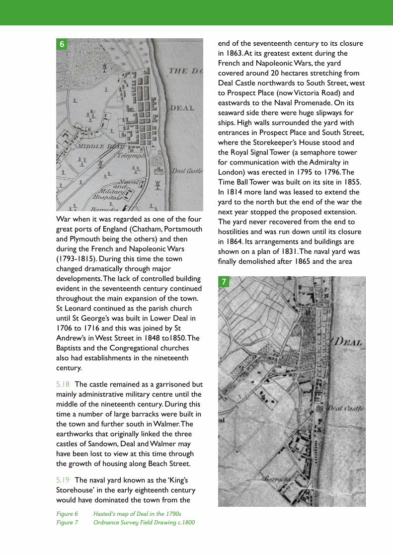
Figure 6 Hasted's map of Deal in the 1790s
Figure 7 Ordnance Survey Field Drawing c.1800
War when it was regarded as one of the four great ports of England (Chatham, Portsmouth and Plymouth being the others) and then during the French and Napoleonic Wars (1793-1815). During this time the town changed dramatically through major developments. The lack of controlled building evident in the seventeenth century continued throughout the main expansion of the town. St Leonard continued as the parish church until St George’s was built in Lower Deal in 1706 to 1716 and this was joined by St Andrew’s in West Street in 1848 to1850. The Baptists and the Congregational churches also had establishments in the nineteenth century.
5.18 The castle remained as a garrisoned but mainly administrative military centre until the middle of the nineteenth century. During this time a number of large barracks were built in the town and further south in Walmer. The earthworks that originally linked the three castles of Sandown, Deal and Walmer may have been lost to view at this time through the growth of housing along Beach Street.
5.19 The naval yard known as the ‘King’s Storehouse’ in the early eighteenth century would have dominated the town from the
end of the seventeenth century to its closure in 1863. At its greatest extent during the French and Napoleonic Wars, the yard covered around 20 hectares stretching from Deal Castle northwards to South Street, west to Prospect Place (now Victoria Road) and eastwards to the Naval Promenade. On its seaward side there were huge slipways for ships. High walls surrounded the yard with entrances in Prospect Place and South Street, where the Storekeeper’s House stood and the Royal Signal Tower (a semaphore tower for communication with the Admiralty in London) was erected in 1795 to 1796. The Time Ball Tower was built on its site in 1855. In 1814 more land was leased to extend the yard to the north but the end of the war the next year stopped the proposed extension. The yard never recovered from the end to hostilities and was run down until its closure in 1864. Its arrangements and buildings are shown on a plan of 1831. The naval yard was finally demolished after 1865 and the area
6
7

Dover District Heritage Strategy
that it occupied was developed with residential properties as Victoria Town.
5.20 The rapid growth of the town in the eighteenth century saw an explosion of speculative development along the three main roads (Lower, Middle and Beach Streets) and the east west streets connecting them and the beach. There were c.700 houses in Lower Deal in 1758 and this rose to 1348 by 1811. The town spilled into the side roads and on to market gardens on the west side of the High Street. Until 1865 the Navy Yard formed the southern boundary of the residential town while North Street formed that at the north. The town had reached its peak by the end of the Napoleonic War and soon declined. The military and naval barracks were said to be in a great state of dilapidation by 1823.
5.21 By the end of the eighteenth century, Deal had attempted to establish itself as a seaside resort. Hotels, the Royal Adelaide Baths, a reading room and other attractions for visitors were built along the beach. Bathing machines had been installed in 1754. A theatre and assembly rooms were built in 1800 though probably to entertain the military and naval personal and their families as much as for holidaymakers. From 1826 the
annual Deal Regatta was established and in 1834 the seafront improved by the demolition of houses on the east side of Beach Street to make way for the North Parade and the South Parade. In 1838 John Rennie was commissioned to build a pier just north of the Royal Hotel. Although started it was never finished and was destroyed by a storm in 1857. It was replaced by an iron structure in 1864 which survived until the Second World War when it was struck by a mined Dutch ship. The present concrete and steel pier, the last intact leisure pier in Kent, was opened in 1957 by the Duke of Edinburgh. Deal never realised its ambitions as a successful resort town, not even when the railway reached it in 1847 and was extended to Dover in 1881.
5.22 The naval presence in Deal stimulated maritime activities both in the town and the naval yard. The most important of these were boat building and there were boat yards in Deal until the end of the nineteenth century. The navy adopted the Deal cutter as its official lighter in 1740 and for the next 50 years these were all built in the town. Other small craft such as luggers, yachts and ten oared galleys for smugglers were also built. As late as 1847, there were still six boat yards in the town despite the general decline of the
8
Figure 6 The expansion of Deal shown on 19th and 20th century Ordnance Survey maps (Conservation Areas are highlighted in red and Deal Castle in blue). The maps are left to right: Landmark Series 1871 - 1890; 1929-1952 and the modern map
trade. The last boat was built in 1896 in Nicholas’ Yard at the north end of the town. As Deal had only a shelving beach and no harbour facilities the yards would have been situated close to the shore and employed slipways across the beach. The site of one yard is known on the west side of South Street. The central strip of the street was cobbled to act as a slipway and finished vessels were hauled along it from the yard to the sea. Many of the east west streets may have served the same purpose. The cutters of the Downs were replaced by steam tugs from 1840 and the boatmen lost their livelihood.
5.23 Other trades grew to serve the navy and other mariners. Ropes, sails and sacks were made; there were tallow chandlers and gunsmiths. There were large numbers of inns to provide entertainment for the military and naval personnel. Smuggling was rife in Deal and played an important part in the town’s economy. At its peak between 1730 and 1780 more than half the town’s male population gained their livelihood from it. The expansion of the town saw the growth of a brick making industry in the town’s surroundings. A number of the clay pits are still visible today.
5.24 In the twentieth century the military and marine barracks on the outskirts of the town were influential in extending its built-up area into Walmer and Upper Deal. The establishment of the East Kent Coalfields influenced the expansion of the town in the pre-war years, particularly in the Mill Hill area to the west. By 1981 the census recorded a population of over 26,000 in Deal and Walmer. The barracks were closed during the 1980s and 1990s with a resultant decline in the prosperity of the town and a decline in its population.
Conservation Area Overviews
5.25 In the absence of Conservation Area Appraisals the work for the Dover District Heritage Strategy has involved the
compilation of a number of Conservation Area Overviews covering a sample of 19 Conservation Areas in the District. These have been rapidly compiled using desk-based research and observation of the areas through Google Street View. They are not intended as comprehensive studies of each Conservation Area but have been developed to gain some insight into the character and condition of the Conservation Area.
5.26 The Conservation Areas forming part of this case study, Middle Street, Nelson Street and Victoria Road & Wellington Road were all included within the Conservation Area Overview sample. For the present case study the areas were visited and partially walked (19th March 2012) to understand in more detail the issues that form a part of this case study. The observations for each of the Conservation Areas are described below.
Observations on Middle Street Conservation Area
5.27 Deal Middle Street was Kent’s first Conservation Area designation and is based around the historic core of the town. It contains the second largest concentration Listed Buildings in Dover District, its 291 Listed Buildings being only second to the Sandwich Walled Town Conservation Area (419 Listed Buildings). There is little doubt that the original Conservation Area was drawn to capture the main concentration of Listed Buildings in Deal and that their presence has greatly assisted in the preservation of historic and architectural quality of the Conservation Area. In addition Middle Street Conservation Area also benefits from the use of Article 4(2) Directions to preserve architectural and historic features of non-listed buildings in the Conservation Area.
5.28 As a result of the protection offered through the large number of Listed Buildings and an Article 4(2) direction the original 1968

Dover District Heritage Strategy
Figure 9 & 10 Shop fronts making a positive contribution
Figure 11 & 12 Signage and shop front design can detract
designated Middle Street Conservation Area has retained much of its character and appearance.
5.29 The original residential part of the Conservation Area was extended sometime in the late nineteen seventies to include the High Street and a number of adjacent residential streets to the west. There is no available documentary evidence on the condition of the extended Conservation Area at the time of its designation. Within the extended area there are numerous alterations to shop fronts and signage as well as the loss of original features such as windows and boundary walls. These losses indicate that the later extension to the Conservation Area has either not fared as well since designation or possibly was not of the same quality as the original area when the extension was designated.
5.30 The main shopping area of the town forms a large part of the extended Conservation Area. This has a variety of independent and multiple or chain shops along the High Street which is in part
pedestrianised. The quality of shop fronts makes a significant contribution to the character and appearance of the Conservation Area. Where little consideration has been given to the special interest of the Conservation Area the negative impact of poor shop front designs and unsympathetic signage can be overwhelming. Generally there are more shops in the northern section of the High Street making a positive contribution to the Conservation Area than the southern section.
5.31 The quality of shop fronts at the northern end of the High Street makes a positive contribution to the Conservation Area. Some buildings detract from the Conservation Area where poor signage and shop front design can be overwhelming.
5.32 The townscape or street design, which is made up of elements such as paving, lighting and signage, also has an impact on the character of the Conservation Area. In the original designated residential areas of Middle Street, pavements and kerbs make a positive
9 10
11 12

Figure 13 &14 Historically sensitive street lighting in Middle Street with granite kerbs and stone pavements
Figure 15 & 16 Incongruous signage & block paving in commercial area of Middle Street
Figure 17 & 18 Street lighting and signage near Deal Castle
contribution. Wide and worn granite kerbs and York Stone paving add quality as well as a
sense of scale and proportion to the streets.
5.33 By contrast the main pedestrian area of the High Street has lost its historic street design, to be replaced with a carpet of block paving that offers little context for the shops and buildings fronting on to it. The result is visually out of character with the Conservation Area, and combined with the poor shop front designs detracts from the character and appearance of the Conservation Area.
5.34 The design and location of street lighting and signage can complement the buildings and streets they adorn. There are a number of streets in the Conservation Area where thought has been given to the siting and design of lighting, whereas in other areas less consideration has been given to the
15
16
17
18
14
13

Dover District Heritage Strategy
subject.
Observations on Nelson Street Conservation Area
5.35 Nelson Street Conservation Area has five Listed Buildings and no Article 4(2) Direction to help to prevent the loss of historic and architectural features. The Conservation area is predominantly a quiet residential area to the west of the northern end of Middle Street Conservation Area. The streets in the area comprise on the whole two storey late Georgian and Victorian terraced houses that front onto the pavement, with the occasional three storey terrace building. The roads in the Conservation Area are generally five to seven feet wider than those in the northern part of Middle Street and as a result allow parking to take place on one side. This has quite an impact on the visual appearance of the street making for a more conventional streetscape. Pavements and kerbs tend to be concrete and the road surfaces are patch repaired in many places.
5.36 A number of buildings have lost
their original timber windows, which does detract from the special interest of the Conservation Area. This is noticeable, when compared with the residential areas of Middle Street Conservation Area.
5.37 At the junction of Water Street and High Street there are two corner sites currently occupied by garage workshops within older buildings, the origins of which need further research. These two corner sites are significant in that they offer potential to enhance the Conservation Areas of both Nelson Street and Middle Street Conservation Areas although they are presently within neither.
Observations on Victoria Road and Wellington Road Conservation Area
5.38 Victoria Road and Wellington Road Conservation Area has seven Listed Buildings and no Article 4(2) Direction to help to prevent the loss of historic and architectural features. It is characterised by larger terrace buildings than those seen in the Nelson Road Conservation Area.
5.39 Many domestic dwellings have lost their original timber windows and boundary treatments, which has detracted from the special interest of the Conservation Area. Gilford Road is one of the main approach roads into the town and located at the southern end of the Conservation Area. The considerable loss of historic windows and boundary treatments not only detracts from the Conservation Area, but also the
19
20 21
Figure 19 Street Parking in the Nelson Street Conservation Area
Figure 20 & 21 Corner sites on the corner of Water Street and High Street

introduction to the historic town.
5.40 Opposite the junction of Gilford Road and Victoria Road is Deal Castle. This is unfortunately screened at this junction behind overgrown trees and hedges. The loss of this aspect of the castle from one of the main approaches into the town is compounded by poorly maintained signage, street lighting and interpretation information, haphazardly presented and in the case of the interpretation is visually separated from its subject. The prospect of trees screening the road may be preferable for the castle, but some compromise to improve glimpses through the screen would be beneficial for the Conservation Area and presentation of the town’s most significant historic building. Lighting, interpretation and signage would also benefit from refurbishment and re-location.
Conservation Area Issues
5.41 A number of recurring issues that are faced for many Conservation Areas within the District have been observed in this case study. These are discussed below with a number of recommendations and guiding principles that should be given consideration to enable the District’s Conservation Areas to be effectively managed.
5.42 Issue 1: Alterations to buildings (and their boundaries) can either enhance or detract from the special interest of a Conservation Area. Likewise neglect and dereliction of a building will have an adverse impact on the Conservation Area.
5.43 The original designated area of Middle Street Conservation Area has remained largely unaltered and presents an attractive collection of historic buildings. Protection to non-Listed Buildings has been provided through the adoption of an Article 4(2) Direction which further assists in the preservation of the Conservation Area. This is
contrasted with the adjacent Conservation Areas of Nelson Street and Victoria & Wellington Road, where there are fewer Listed Buildings and no Article 4(2) Directions to help with the preservation of the area’s special interest.
5.44 Principle: In order to preserve and enhance the special interest of the Conservation Area, the use of Article 4(2) Directions should be applied to Conservation Areas to prevent the loss of historic features and boundaries and to assist in the process of enhancement.
5.45 Issue 2: Shop front design in commercial
Figure 22 Views to Deal Castle are screened by planting from one of the main approaches to the town
Figure 23 Detail of signage
Figure 24 Interpretation visually separated from the Castle
22
23
24
Dover District Heritage Strategy
quarters has a significant impact on the special interest of the Conservation Area. The design and maintenance of signage on buildings can either enhance or detract from the character of the Conservation Area.
5.46 Shop fronts and signage in the northern section of Middle Street Conservation Area are generally of a more attractive and sympathetic design than those in the main shopping area to the south, including Broad Street. To a lesser degree shop fronts in Beach Street vary in quality and design. Shop front and signage design continues to decline in quality and appearance.
5.47 Principle: Shop front design guidance should be rigorously applied to achieve the objectives of enhancing the streetscape. Local Authorities with commercial Conservation Areas have elsewhere had particular success through combining guidance with enhancement grants.
5.48 Issue 3: The public roads and pavements or streetscape around buildings make a significant contribution to the special interest of a Conservation Area and offer opportunities for both preservation and enhancement of the Conservation Area.
5.49 In Middle Street the original wide granite kerbs and surviving York Stone paving offer scale and proportion to the buildings fronting them and enhance their setting. In contrast the High Street pedestrian area reflects nothing of the historic street pattern, both in design and use of materials, and is an alien environment for the setting of the historic buildings there. Residential areas with concrete kerbs and tarmac pavement are out of keeping with the character of the conservation area. Poorly considered street lighting and signage also detract from the Conservation Area.
5.50 Principle: When carrying out street enhancement ensure consideration is given to
the scale of buildings and historic character of the Conservation Area and to the appropriateness of the materials to be used for road and pavement surfaces and kerbs. Lighting and signage should be carefully designed and sited so as to contribute to the character of the Conservation Area.
5.51 Issue 4: The presentation and interpretation of significant heritage assets offers the opportunity to promote the appreciation and understanding of the Conservation Area.
5.52 Middle Street Conservation Area has its origins in Deal Castle. The visual association of the castle with the town is reduced through poor landscape management within the castle grounds. The town has a good range of interpretation panels, but some need renewing or re-locating in order to enhance the setting of the Conservation Area.
5.53 Principle: Landscape management around Deal Castle, in particular overgrown trees and hedges to the north west of Deal Castle should be thinned to allow glimpses from the approach roads. Signage of assets and interpretation in the Conservation Areas should be carefully considered to ensure a positive contribution to the Conservation Area.
5.54 Issue 5: Public open space is a valued component of a Conservation Area offering the opportunity to greatly enhance the visitor and resident experience. Both seafront and green space in the Conservation Area can enhance its special interest.
5.55 Middle Street Conservation Area benefits from its seafront, Deal Castle and St George’s churchyard, which are all open spaces that contribute to the special interest of the Conservation Area. To a greater or lesser degree these assets could offer further enhancement to the Conservation Area and the enjoyment for those living in or visiting the town.

5.56 Principle: Ensure that the visitor and resident appreciation and experience of the Conservation Area is considered. Careful consideration of the use of grounds at St Georges Churchyard would greatly benefit the visitor and resident appreciation of the Conservation Area.
5.57 Issue 6: Research and understanding of the special interest of the District’s Conservation Areas through the process of Conservation Area Appraisal will enable an appreciation of the significance and special interest of the Areas by those involved in the preservation and enhancement of the Conservation Area.
5.58 The lack of Conservation Area Appraisals for the Conservation Areas in Dover District mean that there is very limited current information and understanding of what is of special interest and significance for each of the Conservation Areas. Consequently those who are involved in making changes or managing change within Conservation Areas and their settings are unable to properly appreciate how those changes will affect the special interest, appearance and character of the Conservation Area. Inevitably, without informed management based upon a sound understanding of what is significant, the result will be gradual loss of the special interest of the District’s Conservation Areas.
5.59 Principle: A priority for Dover District must be to carry out the process of Conservation Area Appraisal for all the Conservation Areas to avoid the loss of the special interest of those much valued areas. Conservation Area Appraisals which are regularly reviewed have a number of benefits: the public are able to understand what is important about an area; they can guide those proposing alterations within or close to Conservation Areas; and they can help planners to evaluate proposals that affect Conservation Areas and be taken account of in any subsequent planning appeal where a
proposal is refused. Conservation Area Appraisal should also help to identify opportunities to enhance the special interest of Conservation Areas and provide a mechanism for a regular health check of the heritage asset.
5.60 Issue 7: The management of the Conservation Area through Conservation Area Management policies and the development control process.
5.61 It is essential that clear direction on appropriate change, either through development or alteration, within the Conservation Area, is available to reduce the adverse impact that change can have on the special interest of the Conservation Area.
5.62 Principle: Producing Conservation Area Management Plans in consultation with stakeholders for the Conservation Area will set out clearly the aims and objectives of preserving and enhancing the conservation area.
5.63 The following English Heritage guidance is available for Conservation Area Appraisals and Management Plans:
• Understanding Place: Conservation Area Designation, Appraisal and Management;
• Valuing Places: Good Practice in Conservation Areas;
• Constructive Conservation In Practice.
5.64 Toolkits are also being developed which enable the voluntary sector to undertake Conservation Area Appraisals of their special areas and assist Local Authorities in their monitoring role.