appendix 4 meteo-hydrology and water resource -...
TRANSCRIPT
Appendix 4 Meteo-hydrology and Water Resource

- i -
MASTER PLAN STUDY ON
INTEGRATED AGRICULTURAL DEVELOPMENT IN
LAO PEOPLE’S DEMOCRATIC REPUBLIC
VOLUME III
APPENDIX-4
METEO-HYDROLOGY AND WATER RESOURCE
Table of Contents
Page
CHAPTER 1 INSTITUTION AND ORGANIZATION ............................................... AP4-1
1.1 Agencies in Meteo-hydrology and Water Resources...................................... AP4-1
1.1.1 Department of Meteorology and Hydrology and Department of Meteo-hydrology of PAFS ........................................................... AP4-1
1.1.2 Offices, Staff, Instruments and other Facilities ................................ AP4-2
1.1.3 Compilation of Meteo-hydrological Data......................................... AP4-3
1.2 Water Resources Coordination Committee .................................................... AP4-3
1.3 Water Resources Policy .................................................................................. AP4-4
CHAPTER 2 METEO-HYDROLOGICAL OBSERVATION ...................................... AP4-6
2.1 Climate in Lao PDR ....................................................................................... AP4-6
2.2 Meteorological Observation Network ............................................................ AP4-6
2.3 Hydrological Observation Networks .............................................................. AP4-7
2.4 Constraints and Proposed Development Programs ........................................ AP4-8
2.4.1 Constraints of Meteo-hydrology Observation .................................. AP4-8
2.4.2 Development Strategies and Programs on Meteo-hydrology Sub-sector ......................................................................................... AP4-9
CHAPTER 3 INSTALLATION OF NEW METEO-HYDROLOGY STATIONS...... AP4-10
3.1 General.......................................................................................................... AP4-10
3.2 Review of Site Selection and Modification of Sites..................................... AP4-10
3.2.1 Review of Site Selection................................................................. AP4-10
3.2.2 Modification of Site Selection ........................................................ AP4-12
3.3 Topographical Survey and Detailed Design of Hydrology Stations............. AP4-13
3.3.1 Topographical Survey of Slope Gauge Station............................... AP4-13
3.3.2 Detailed Design .............................................................................. AP4-13

- ii -
Page
3.3.3 Preparation of Technical Specifications ......................................... AP4-13
3.4 Construction Management............................................................................ AP4-13
3.5 Work Progress of Construction and Final Mutual Checks ........................... AP4-14
3.6 Procurement of Automatic Recorder............................................................ AP4-14
3.7 Installation of Equipment for Communication and Data Compilation......... AP4-15
3.8 Operation of Hydrology Station and Data Collection .................................. AP4-15
CHAPTER 4 WATER RESOURCES.......................................................................... AP4-16
4.1 Surface Water................................................................................................ AP4-16
4.1.1 River Basin ..................................................................................... AP4-16
4.1.2 Hydrological Data........................................................................... AP4-16
4.1.3 Monthly Rainfall in Ordinary Hydrological Year........................... AP4-16
4.1.4 Drought Rainfall and Estimation of Rainfall in River Basin.......... AP4-17
4.1.5 Annual Runoff Ratio....................................................................... AP4-17
4.1.6 Annual Runoff in Ordinary Hydrological Years............................. AP4-18
4.1.7 Specific Drought Discharge of Main Rivers .................................. AP4-18
4.2 Groundwater ............................................................................................... AP4-19
4.3 Water Quality................................................................................................ AP4-20
List of Tables
Page
Table 1.1.1 Present Staffing of DMH and Provincial Meteo-Hydrology Division .............................................................................................. AP4T-1
Table 1.1.2 Present Conditions of Office and Communication System of DMH and Provincial Meteo-Hydrology Division .............................. AP4T-2
Table 1.1.3 Instrument and Equipment for Observation at DMH and PMHD (1/2-2/2).............................................................................................. AP4T-3
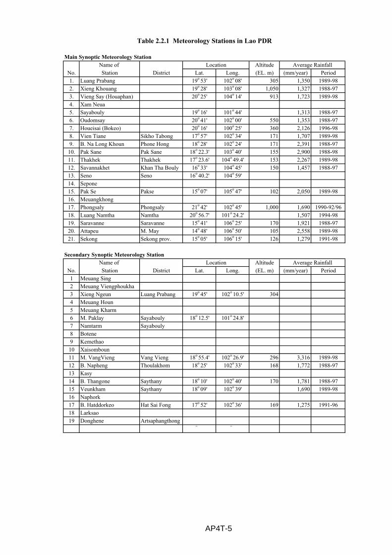
Table 2.2.1 Meteorology Stations in Lao PDR...................................................... AP4T-5
Table 2.2.2 Rain Gauging Stations in Lao PDR (1997) (1/3-3/3)......................... AP4T-6
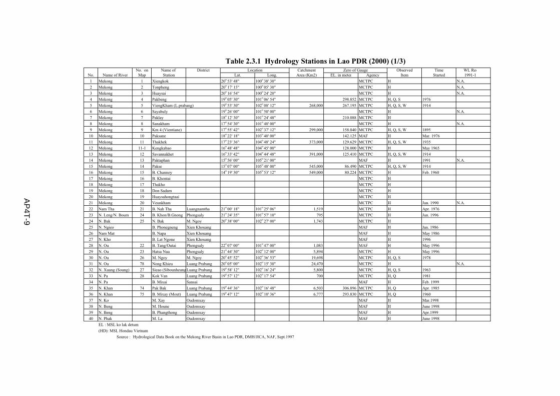
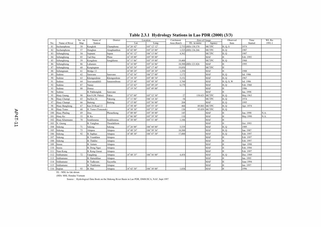
Table 2.3.1 Hydrology Stations in Lao PDR (2000) (1/3-3/3).............................. AP4T-9
Table 2.3.2 Dry Season Discharge of Mekong's Tributatries in Lao PDR.......... AP4T-12
Table 3.2.1 Identified Matters of Proposed Rain Gauge and Staff Gauge Stations (1/3-3/3) .............................................................................. AP4T-13
Table 3.7.1 Proposed Transceiver and Generator Set.......................................... AP4T-16
Table 3.7.2 Proposed Computer and Generator Set ............................................ AP4T-17

- iii -
Page
Table 3.8.1 Rainfall 2001 (1/7-7/7) ..................................................................... AP4T-18
Table 4.1.1 Hydrological Stations and Available Data (1/2-2/2)......................... AP4T-25
Table 4.1.2 Mean Monthly Rainfall in Ordinary Hydrological Year (1/2-2/2) ... AP4T-27
Table 4.1.3 Drought Rainfall (Point Rainfall)T=5 years (1/2-2/2)...................... AP4T-29
Table 4.1.4 Drought Rainfall estimated in the each River Basin (T=5 years) (1/3-3/3)............................................................................................ AP4T-31
Table 4.1.5 Annual Runoff in Ordinary Hydrological Year (1/2-2/2) ................. AP4T-34
Table 4.1.6 Monthly Mean Discharge of Major Rivers in Lao PDR................... AP4T-36
Table 4.1.7 Annual Runoff Ratio in Drought Year............................................ AP4T-37
List of Figure
Page
Figure 1.1.1 Organization Chart of Department of Meteorology and Hydrology, MAF and Provincial DMH ................................................................. AP4F-1
Figure 2.1.1 Average Annual Rainfall (mm)........................................................... AP4F-2
Figure 3.2.1 Location of Hydrology Station Constructed Under JICA Program (2000-2001) ........................................................................................ AP4F-3
Figure 3.7.1 Location of Transceiver Site ............................................................... AP4F-4
Figure 3.7.2 Installation of Computer Unit ............................................................. AP4F-5
Figure 4.1.1 Location of Map of the River the Mekong River Basin).................... AP4F-6
Figure 4.1.2 Location Map of the River (Outside of the Mekong River Basin) ..... AP4F-7
List of Attachment
Attachment-1 Report on Construction of Slope Gauge and Rain Gauge Stations
AP4-1
MASTER PLAN STUDY ON
INTEGRATED AGRICULTURAL DEVELOPMENT IN
LAO PEOPLE’S DEMOCRATIC REPUBLIC
VOLUME III APPENDIX-4
METEO-HYDROLOGY AND WATER RESOURCE
CHAPTER 1 INSTITUTION AND ORGANIZATION
1.1 Agencies in Meteo-hydrology and Water Resources
There are two government’s agencies responsible for providing services on the meteo-hydrology and water resources. One is the Department of Meteorology and Hydrology (DMH) of MAF that has mandate to collect, evaluate and disseminate rainfall, evaporation, river height and flow information. The other is the Department of Communication of MCTPC that is responsible for collecting hydrologic and hydrographic data on the Mekong River and its main tributaries. The DMH plays a dominant role in management of the meteo-hydrological networks over the country in providing a wide range of services from observation to forecasting.
1.1.1 Department of Meteorology and Hydrology and Department of Meteo-hydrology of PAFS
The DMH has office in Vientiane with about 75 staff, and its organization chart is shown in Figure 1.1.1. Under the DMH, 17 local meteo-hydrological offices are deployed in the respective Provinces with 135 staff belonging to PAFS and DAFO. The duties of DMH are (i) meteorological observation, (ii) aviation meteorology, and (iii) hydrological observation
Roles of DMH are to strengthen/construct meteo-hydrological station network in Lao PDR, to provide technical assistance to the Department of Meteo-hydrology of PAFS (DMHP), to compile the collected meteo-hydrological data, to provide meteo-hydrological information for public services and other government agencies concerned. Roles of the DMHP are to carry out observatory activities, to maintain meteo-hydrological stations and to send daily and/or periodical reports on the observed data to the DMH through PAFS.

AP4-2
1.1.2 Offices, Staff, Instruments and other Facilities
In accordance with the latest information of DMH, present conditions of offices and related facilities for observation activities of the DMH and DMHP can be summarized below.
(1) Office
Following offices concerned with meteo-hydrology observation are located overall Lao PDR.
- Meteorology station including DMH office (Main synoptic meteo-hydrology station) 21 stations
- Agro-meteorological station and/or Secondary Synoptic meteo-hydrology station 29 stations
- Rain gauge stations 102 stations - Staff gauges stations 60 stations - Gauging stations 67 stations
(2) Staffing
(i) Most of qualified staffs such as Sr. Meteorologist, Sr. Hydrologist and Sr. Data analyst are doing main services in DMH office. Main meteo-hydrology office is respectively located at 17 PAFS, but out of 17 PAFS, only 5 PAFS namely, Provinces of Luang Prabang, Vientiane, Borikhamsay, Savannakhet and Champasak have a few meteorologist and hydrologist.
(ii) Main workers of all DMHP are permanent field staff for data collection.
(3) Communication system
(i) Tele-communication system has already attained all main meteo-hydrology stations, but network of tele-communication does not fully attain into all hydrological stations and agro-meteorological stations. Main communication system for data transferring is currently wireless radio system. But, wireless radio system is not unsuitable to carry out data transferring to Vientiane clearly, because of over-durability period of wireless radio equipment and worse affection from weather conditions.
(ii) Power resource of automatic recorder, data compilation and communication is mainly electricity at all main meteo-hydrology stations. However, main meteo-hydrology station does not have the 24-hours electricity power supply in Xaiyabuly Province.
(iii) Most of communication facilities, observatory instrument and equipment are of over-durability period, and replacement and/or renewal of facilities and instrument need.

AP4-3
(4) Transportation
(i) Except for DMH, all DMHP have very poor conditions of transportation for activities of observatory and reporting.
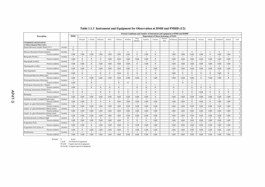
(5) Meteo-hydrology instrument and equipment
(i) In accordance with categorization of DMH, meteorology station is broadly divided into two groups such as meteorological station and agro-meteorological station. But there is no difference on installation of instruments for observatory.
(ii) Most of instruments for meteorological observatory are being of over-durability period and still in use. But, it can be recommended to carry out early calibration of instruments, and renewal and/or replacement of instruments are also discussed, if necessary.
(iii) Most of hydrological instruments are not frequently maintained well.
(iv) Network of hydrological stations has not been fully expanded into mountainous area due to poor accessibility to remote areas.
Detailed information on the matters is shown in Tables 1.1.1 to 1.1.3.
1.1.3 Compilation of Meteo-hydrological Data
DMHP has responsibility to prepare and submit regular reports on meteo-hydrology observatory to DMH everyday and/or periodically. In the reporting mechanism, each main meteo-hydrology station of DMHP has to submit report on meteo-hydrological data to DMH everyday, using telecommunication system. But, in cases of secondary synoptic meteo-hydrology stations and agro-meteorology stations, it takes approximately 3 months to 6 months to send the collected data to the DMH after collection of meteo-hydrological parameters. Finally, Statistic Data Center of DMH compiles all collected data by computer. However, compiling/filing and examination of meteo-hydrological data are very poor at the DMH due to shortage of manpower and no updated management of computer. For examples, it was identified that runoff data such as water level and river discharge have been collected and compiled at more than 35 stations, but longer-term data of more than 10 years are compiled at only 11 stations of 9 river basins.
1.2 Water Resources Coordination Committee
The Water and Water Resources Law, enacted in October 1996, sets out the principles, rules and measures in administration, exploitation, use and development of water and water resources. The Law is composed of ten provisions with 49 articles, containing protection of water resources and their

AP4-4
watersheds, water resources planning, and the prevention of water pollution. Ministries active in water resources have been instructed to formulate ministerial regulations to reflect the intent of the Law.
With setting of legal framework on water and water resources, GOL established the Water Resources Coordination Committee (WRCC) in April 1998 as a national apex body with an aim at improving the coordination of multi-sectoral activities involving various water uses and also defining and managing water allocations. ADB provided GOL with a technical assistance in 1997-1998 for institutional strengthening of the WRCC. The WRCC is composed of the vice-chairperson of STEA as the Chairperson of WRCC and representatives of the seven organizations nominated by the Prime Minister’s Office. These are MAF as the vice-chairperson of WRCC, MIH, MCTPC, Ministry of Public Health (MPH), Ministry of Justice (MJ), Lao National Mekong Committee (LNMC) and STEA. The WRCC has its own Secretariat located within STEA.
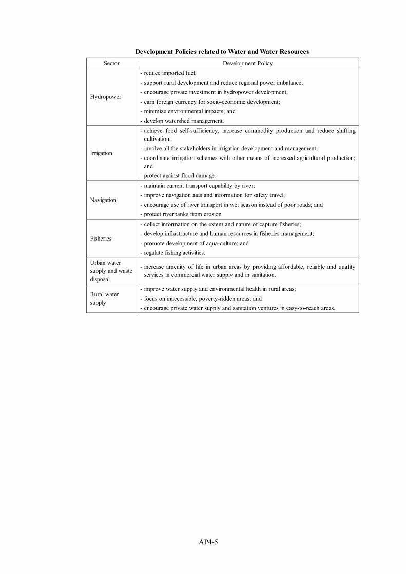
1.3 Water Resources Policy
There have been no clear overall policy for the water sector in Lao PDR, but it could be gradually set up by augmenting and adjusting the individual policies of water related sectors with the establishment of WRCC. GOL is undertaking further development of the legal and regulatory framework for water and water resources and for the preservation of the environment. The development aims at reducing the conflicts between the sectors caused through development. The water related sectors are; hydropower, irrigation, navigation, fisheries, urban water supply and waste disposal, and rural water supply. The respective sectors’ development policies related to water and water resources are briefly summarized below.
AP4-5
Development Policies related to Water and Water Resources
Sector Development Policy
Hydropower
- reduce imported fuel;
- support rural development and reduce regional power imbalance;
- encourage private investment in hydropower development;
- earn foreign currency for socio-economic development;
- minimize environmental impacts; and
- develop watershed management.
Irrigation
- achieve food self-sufficiency, increase commodity production and reduce shifting cultivation;
- involve all the stakeholders in irrigation development and management;
- coordinate irrigation schemes with other means of increased agricultural production; and
- protect against flood damage.
Navigation
- maintain current transport capability by river;
- improve navigation aids and information for safety travel;
- encourage use of river transport in wet season instead of poor roads; and
- protect riverbanks from erosion
Fisheries
- collect information on the extent and nature of capture fisheries;
- develop infrastructure and human resources in fisheries management;
- promote development of aqua-culture; and
- regulate fishing activities.
Urban water supply and waste disposal
- increase amenity of life in urban areas by providing affordable, reliable and quality services in commercial water supply and in sanitation.
Rural water supply
- improve water supply and environmental health in rural areas;
- focus on inaccessible, poverty-ridden areas; and
- encourage private water supply and sanitation ventures in easy-to-reach areas.
AP4-6
CHAPTER 2 METEO-HYDROLOGICAL OBSERVATION
2.1 Climate in Lao PDR
The tropical climate of Lao PDR is mainly dominated by south-west monsoons and typhoons. The rainy season starts in mid-April and lasts until mid-October, and the rest period is the dry season. Average annual rainfall ranges from 1,650 mm to 1,950 mm. Rainfall of more than 90 % is concentrated into the rainy season in the each area. In accordance with isohyetal map shown in Figure 2.1.1, rather higher annual rainfall of more than 2,500 mm is identified in two regions such as (i) northern and eastern area of Vientiane Province to western area of Borikhamxai Province and (ii) Boloven Plateau. On the contrary, the regional area of Xaignabouri Province to southern area of Louangphrabang Province has comparatively lower annual rainfall of less than 1,300 mm.
Mean temperature ranges 22.4°C to 29.1°C. Mean Maximum temperature increase more than 32°C in low land areas during transition period from dry season to rainy season. Mean Minimum temperature come down several times less than 10°C in low land area in dry season, and a few occurrence of frost can be identified in high mountainous area of more than 1,200 m above mean sea water level in dry season.
2.2 Meteorological Observation Network
Meteo-hydrological stations of Lao PDR are classified into 3 types such as main meteo-hydrology station (main synoptic station), agro-meteorology station and Secondary synoptic meteo-hydrology station. However, there are no deference of the roles and functions between the agro-meteorology station and the Secondary synoptic meteo-hydrology station. There are 50 meteorological stations over the country with a classification of 21 main synoptic meteo-hydrology station and 29 secondary synoptic meteo-hydrology station and/or agro-meteorology station. The meteorological observation activities by DMH consist of general meteorological observation and aviation meteorological observation.
The observation items of meteorological stations are; temperature (max. & min.), humidity, evaporation, solar radiation, wind speed and direction, and underground temperature at the depth of 5 cm, 10 cm, 20 cm, 50 cm and 100 cm. Of 35 stations, 16 stations operated by the provincial office transfer the observed records to the DMH in Vientiane by wireless transmission at 7 AM everyday. Those at the rest stations are reported on a monthly basis with a delay of one month in general. All the meteorology stations are listed in Table 2.2.1.

AP4-7
The DMH in Vientiane convey the weather forecast to the media at 10 AM and 11 AM everyday, and this information is broadcast three times a day at 7 AM, 10 AM and 7 PM. This forecast is based on the meteorological information transmitted from the Hong Kong sub-stations of the World Meteorological Organization (WMO) at 7 AM, meteorological data from neighboring countries regularly transmitted at 7 AM, 10 AM and 1 PM, photographic information of Japanese satellite “Himawari”, and partly additional meteorological data observed locally.
The DMH operates 12 meteorological stations at Vientiane airport and other 11 local airports; Bokeo, Oudomxai, Luang Namtha, Viengxai, Xiangkhouang, Louangphrabang, Xaignabouri, Savannakhet, Saravan, Pakse and Attpu. These stations provide aviation meteorological information including visibility, cloud conditions, rainfall, atmospheric pressure and air temperature.
The DMH made inventory survey on all the rain gauging stations over the country with a technical guidance of a JICA expert in 1997, together with collecting daily rainfall records for six year period from 1991 to 1996. The results of inventory survey are shown in Table 2.2.2. The results of survey revealed that the management of rainfall gauging stations is in very poor conditions. The stations which properly observed and hold the record during 1991 - 1996 are as low as about 40%, and about half of stations are out of functions. Those in the northern mountain area are remarkably poor.
2.3 Hydrological Observation Networks
Hydrology stations have been established at 116 sites over the country for observatory of the Mekong River and its main tributaries as shown in Table 2.3.1. However, observation activities are stopped at 12 of water level gauge stations due to technical and management reasons such as insufficient maintenance works of equipment/instrument, shortfall of consumable materials, lack of staff, shortage of budget, etc. The operating hydrology stations consist of 60 stations managed by DMH and the other 42 stations operated by the MCTPC. The observatory items are shown in the following table.

AP4-8
Observatory Item of Hydrology Station
Water quality has to analyzed once a month at the laboratory of the Department of Irrigation (DOI) for 13 items including pH, EC, Ca+Mg, Ca, Mg, Na, CO3, HCO3, Cl, SC4, SAR, and B. However, only a few stations follow the required observatory operation as designated above, and most cases are only water level observation. Water level has to be observed five times a day at 7:00, 10:00, 13:00 and 16:00 in the rainy season of May to September, and twice at 7:00 and 19:00 in the dry season. However, twice a day is prevailing.
The DMH carried out the measurement of river flow discharge of the Mekong’s tributaries in the dry season with an assistance of JICA expert, and this result are reported in May 1998 as shown in Table 2.3.2. Although all the measured records do not indicate the least dry season discharge, these are very valuable date in assessment of river characteristics in the dry season. These data revealed that the characteristics of river basins, in terms of unit runoff (lit/sec/km2), are not always similar in the adjacent basins.
2.4 Constraints and Proposed Development Programs
2.4.1 Constraints of Meteo-hydrology Observation
Present constraints of meteo-hydrology observation are summarized below.
(i) Observation activities of each meteo-hydrological station have been suffered from insufficient type/kind of instrument/equipment, deterioration of instrument/equipment and facilities, lack of qualified staff and shortfall of budget.
(ii) Density of meteo-hydrological stations is insufficient to provide a meaningful interpretation of local weather mechanism as well as weather and flood forecast.
(iii) Functions of agro-meteorology station are very poor and agro-meteorological information has not been obtained sufficiently to support farmers’ agricultural activities due to deterioration of instrument/equipment and facilities and lack of qualified staff.
Observatory Item No. of Station DMH Station MCTPC StationWater Level, Discharge,Silting and Water Quality 10 6 4
Water Level, Dischargeand Silting
8 4 4
Water Level andDischarge 32 17 15
Water Level 54 33 21Total 104 60 44
Observatory Item of Hydrology Station
AP4-9
(iv) Weather forecast does not timely and effectively run due to insufficient information on regional meteo-hydrology. This conditions are caused by no access to the Global Telecommunication System (GTS), which supplies wide range meteo-hydrological data in and around the Lao PDR, no upper-air stations and weather surveillance radar center.
(v) Reliability and quality of meteo-hydrological data is very poor, because of lack of facilities for calibration and maintenance of meteo-hydrological instruments.
2.4.2 Development Strategies and Programs on Meteo-hydrology Sub-sector
In accordance with Draft Development Program on Meteo-hydrology Sub-sector, Vision 2020 prepared by DMH (2000), the DMH has proposed the following main development strategies and programs to encounter the constraint mentions above.
(i) Strengthening weather forecast and flood forecast through rehabilitation of facilities and renewal and/or upgrading of instruments at meteo-hydrology stations located in the 7 granary plains of Lao PDR
(ii) Strengthening weather and flood observation activities in remote areas of Lao PDR through expansion of meteo-hydrology stations
(iii) Strengthening wide and high weather forecast through establishment of upper air observatory and upgrading of satellite observatory
(iv) Strengthening data collection through improvement of transportation and updating of data compilation through improvement of communication system and upgrading of data base system
(v) Capacity building of DMHP staffs through implementation of 1.5 year-training program at DMH and other training programs
(vi) Strengthening quality of the collected data through establishment of meteo-hydrology laboratory

AP4-10
CHAPTER 3 INSTALLATION OF NEW METEO-HYDROLOGY STATIONS
3.1 General
Contracts on construction of hydrology stations consisting of 11-slope gauge and 15-rain gauge stations have been mutually agreed in October 2000 between JICA Lao Office and the Contractors. The contracts are broadly divided into (i) construction works and (ii) procurement works of hydrological instruments and other goods.
Under these conditions, the technical assistance services were carried out in respective implementation stage of the works including transfer of knowledge to counter personnel and DMH staff concerned. Hydrologist of the JICA Study Team has provided and given the following technical assistance in the each stage such as plan, design and supervision of construction of hydrological stations, supervision of installation of hydrological instruments, communication equipment and other goods
(a) Technical review on the 15 hydrological station sites proposed by JICA Expert of DMH,
(b) Modification of site selection based on the field survey, (c) Preparation of additional materials for contract documents on construction
works of hydrological stations and installation works of hydrological instrument, communication equipment and other goods,
(d) Preparation of necessary materials for supervision of construction works, (e) Preparation of technical instructions, suggestions and recommendation
on the construction work and the installation works, (f) Transfer of technical knowledge on construction and management of
hydrological stations to the counter personnel and DMH staff concerned.
3.2 Review of Site Selection and Modification of Sites
3.2.1 Review of Site Selection
JICA Expert of DMH has already selected 15 hydrological stations consisting of 11 slope gauge stations and 15 rain gauge stations. Main purpose of establishment of these stations is to strengthen hydrological data collection for agriculture development and mitigation of flood damage. In reply to the JICA Expert’s request on technical review, the Hydrologist of the JICA Study Team has carried out field investigation, especially local conditions and suitability of the selected stations. The technical review has been carried out through technical discussion with DMH, Provincial Agriculture and Forestry Service Office (PAFS) and JICA Expert and field investigation. It was evaluated that the originally proposed sites for slope gauge station and rain gauge station are generally appreciated for

AP4-11
construction, while some problems and subjects for construction and management were identified at some stations as summarized below.
(1) Slope Gauge Station
(i) Site selection has been carried out without any consideration on water allocation and relationships of river facilities such as hydropower station, dam, intake structures of irrigation. (In case of Hongluay Station/Nam Tha River)
(ii) Axis of slope gauge is not vertically aligned against main current of river, and/or slope gauge is aligned within area to be affected by main current of river during high water level. These problems were caused due to shortage and lack of detailed topographical information. (in cases of Hat Pha Ot Station/Nam Xuang River, Pak Beng Station/Mekong River and Xiengkok Station/Mekong River)
(iii) It was identified that some slope gauge stations have been aligned in rather wide section of river, comparing to other sections of upper and/or down streams. Technical difficulty on measurement of river discharge will be occurred during high water level. (in case of Pak Ngum Station/Lower reach of Nam Ngum River)
(iv) Some mismatching on plan and design of slope gauge station, which were caused due to any special attention and consideration on soil characteristics of riverbanks, were identified at some stations. (in case of Kengkok Station/Xe Champong)
(v) Very poor sustainability on the project management mentioned below budget is identified at some Meteo-hydrology Office of the each PAFS:
(a) Insufficient understandings of high position PAFS officer on the necessity of
meteo-hydrological observation activities,
(b) Low incentive situation for the officers/workers of Meteo-hydrology Office,
insufficient number of staff,
(c) Low knowledge of technical staff,
(d) Lack of transportation for observation and
(e) Small budget amount for full operation.
(2) Rain Gauge Station
(i) DMH did not carefully considered a development plan on network of rain gauge stations. It was identified mismatching allocation of new rain gauge stations, and the newly proposed station overlapped with the operating rain gauge station.
(ii) DMH did not take any administrative procedure for construction such as negotiation and confirmation on land use with local government, staff arrangement for operation to PAFS, etc after selection of sites for rain gauge stations,

AP4-12
Results of review and field identifications are summarized in Table 3.2.1, and Field Reports on review of site selection are shown in Attachment No. 4.1.
3.2.2 Modification of Site Selection
The subjects and problems have been discussed with DMH, JICA Expert and DMHP, and some modifications on construction plan of the originally proposed stations have been made as shown below. Modified location of the each station is shown in Figure 3.2.1.
(1) Slope gauge Station No. Originally Proposed Location Finalized Location
Village Name River Basin Village Name River Basin ① Xieng Kok Mekong same Confluence of Mekong with
Nam Tha ② Luang Nam Tha Nam Tha Ban Hongluay Nam Tha ③ Ban Pak Beng.¥ Mekong same same ④ Ban Sopchek Nam Suang Ban Hat Pha Oth Nam Suang ⑤ Xieng Khouang Nam Ngum Ban Phieng Luang Nam Ngum ⑥ Ban Naluang Nam Ngum same same ⑦ Vientiane Nabong Nam Ngum Ban Hai Nam Ngum ⑧ Paksane Mekong same same ⑨ Thakhek Mekong same same ⑩ Attapeu Xekong same same ⑪ Xekong Xekong Ban Vieng Thong Nam Lik
(2) Rain Gauge Station No. Originally Proposed Location Finalized Location
Village Province Village Province 1 Xieng Kok Luang Nam Tha same same 2 Luang Nam Tha Luang Nam Tha Ban Hongluay same 3 Ban Pak Beng Oudomxay same same 4 Ban Sopchek Luang Prabang same same 5 Xieng Khouang Xieng Khouang Ban Nam Neun Xam Nua 6 Ban Naluang Xai Songbung S.Z. same same 7 Vientiane Nabong Vientian Ban Hai same 8 Paksane Borikhamxay Ban Pha Muang same 9 Thakhek Khammouane Ban Hin Beun same
10 Mahaxay Savannhket Ban Phonesi Borikhamxay 11 Kengkok Savannhket Ban Chun La Xekong 12 Xepon Salavan Ban Namon Xayabuli 13 Lahanam Savannhket Muang Et Xam Nua
14 Attapeu Attapeu Ban Ken Say same 15 Xekong Xekong Ban Tang Vay same
AP4-13
3.3 Topographical Survey and Detailed Design of Hydrology Stations
3.3.1 Topographical Survey of Slope Gauge Station
Original design of hydrology stations was made without detailed topographical information. It was not clarified whether axis of slope gauge station was properly selected to mitigate damage of slope gauge facility, which will be affected by main current of river discharge during high water level. And furthermore, it was doubtful whether the axis of slope gauge station was properly selected to measure river discharge properly. Therefore, counterpart personnel and staff of DMH have carried out topographical survey under technical supervision of Hydrologist of the JICA Study Team to make more sure design of slope gauge station. Topographical survey started during review works on site selections of hydrology stations.
3.3.2 Detailed Design
Tender drawings of hydrology stations were prepared based on preliminary design. In accordance with the Contract document, the Contractor should make detailed design. However, the Contractor’s activities on these matters were much delayed due to poor capacity of the Contractor. Actually, the Contractor had no qualified engineers to carry out topographical survey and made detailed design.
The DMH started detailed design under technical assistance of Hydrologist of the JICA Study Team to solve the management problems of the Contractor. The works was completed in the middle of January 2001. The DMH supplied the detailed design drawings (sample drawings) shown in the Attachment No. 4.2 to the Contractor together with technical specifications on January 17, 2001.
3.3.3 Preparation of Technical Specifications
Technical specifications on construction of slope and rain gauge stations were not included into the Contract documents, which have already been distributed to the Contractor, and there are no standards to supervise the construction works of slope gauge and rain gauge stations. Therefore, the DMH and the JICA Expert prepared technical specifications based on the results of the detailed design under technical supervision of Hydrologist of the JICA Study Team and supplied to the Contractor as a part of the Contract documents.
3.4 Construction Management
Construction works of slope gauge and rain gauge stations were managed under the following organization.
i) Project owner : Representative of JICA Laos Office, ii) Engineer appointed by Project owner : JICA Expert of DMH,

AP4-14
iii) Coordinator of the Project : Director General of DMH, iv) Supervisory Team of DMH : Counterpart personnel of JICA
Expert and other staff concerned v) Technical Advisor to Engineer and Coordinator : Hydrologist of the JICA Study Team,
and vi) Contractor
Engineer (Project Manager) has basically managed all project activities and works progress together with Coordinator of the Project and Technical Advisor at DMH office, Vientiane. The Project Manager prepared and dispatched the Supervisory Team of DMH to the each site together with Technical Advisor. In occasion of technical and management issues of the works at the each station, the Engineer also carried out field inspection together with the Supervisory Team of the DMH.
3.5 Work Progress of Construction and Final Mutual Checks
After handing over detailed drawings and technical specifications to the Contractor, the JICA Expert and the DMH have strongly requested smooth and prompt actions of construction works. But, commencement of construction works has much delayed due to very poor mobilization management of the Contractor, and the works started at the each station in the middle of February 2001. The Contractor could not accomplish all construction works until the expire date of the Contract (March 8, 2001), and the Contractor requested to extend the contract period up to the end of March 2001.
The Supervisory Team of DMH started supervision on construction of hydrology station as shown in the Attachment No. 4.3. Final mutual checks on construction works of hydrology stations carried out since the beginning of April 2001, and the Engineer issued temporary construction certificate to the Contractors together with technical comments on outstanding works and maintenance works on April 25, 2001.
3.6 Procurement of Automatic Recorder
Automatic recorder of hydrological data (data-loga system) has been procured for operation of slope gauge and rain gauge stations since November 2000. Procurement of all the instruments has been completed at Vientiane in the end of February 2001. Installation and test operation of the automatic recorder (data-loga system) have been completed in April 2001 after accomplishment of concrete works of slope gauge and rain gauge stations. Observation activities started at all station using the recorder. While, it is necessary to carry out minor adjustment of calibration of the automatic recorder after this rainy season.

AP4-15
3.7 Installation of Equipment for Communication and Data Compilation
In line with construction of hydrology stations and procurement of hydrological instruments, other equipment for operation and management such as transceiver and computer have been procured and respectively being installed at 27 meteo-hydrology stations and/or offices as shown in Tables 3.7.1 to 3.7.2. Locations of those facilities installed are shown in Figure 3.7.1 to 3.7.2.
3.8 Operation of Hydrology Station and Data Collection
Observation on water level of river and rainfall started at the each hydrology station in April 2001 using data - loga system. Transferring and compilation of hydrological data started as a test run of operation, but collection of hydrological data, especially transferring the data from automatic recorder to computer system are much suffered from heavy rainfall conditions and transportation problems due to land sliding of partial sections of national roads. The hydrological data collected at the 19 stations are summarized in Table 3.8.1.
AP4-16
CHAPTER 4 WATER RESOURCES
4.1 Surface Water
4.1.1 River Basin
Main rivers of the Lao PDR dominantly consist of the first and second tributaries of the Mekong River. There are about 39 main tributaries in the Mekong River basin. Main rivers that have bigger catchment area of more than 5,000 km2, are the following 10 rivers.
(i) Nam Tha, (ii) Nam Ou, (iii) Nam Xuang, (iv) Nam Khan, (v) Nam Ngum, (vi) Nam Kading, (vii) Xe Banfai, (viii) Xe Bang Hiang, (ix) Xe Done and (x) Xe Kong
Total watershed area of the main tributaries is estimated at about 183,000 km2.
On the other hand, only 2 main rivers, namely Nam Ma River and Nam Ka River are located outside of the Mekong River Basin and expanded in the eastern area of Provinces of Houaphan and Xieng Khuang. Both the rivers flow into the Vietnam area directly. Total watershed area of both the rivers is approximately 15,000 km2.
Nam Ngum River has huge dam reservoir in Vientiane Province. Total storage capacity of the dam is 7,000 MCM, and surface water area of dam reservoir attains 370 Km2 in rainy season. Hydrological information concerned of the each river is summarized as shown in Table 4.1.1. Locations of main rivers and boundaries of river basins are shown in Figures 4.1.1 to 4.1.2.
4.1.2 Hydrological Data
For estimation of surface water resources, hydrological data of more than 10 years was obtained from the DMH and MCTPC. The data obtained were only rainfall data of 59 rain gauge stations and 11 water level gauge stations. It was very a few hydrological data taking into consideration current observation conditions under the hydrological network. Furthermore, it was identified that some data on river discharge have much discrepancies and discontinuity of seasonal sequence, which can not be theoretically explained. This was caused due to very poor conditions of examination and compilation of hydrological data.
4.1.3 Monthly Rainfall in Ordinary Hydrological Year
Monthly rainfall is estimated at the each rain gauge station mentioned above, based on the statistic analysis on the collected data. The monthly rainfall widely ranges from 1,240 mm to 3,770 mm overall Lao. PDR as shown in Table 2.4.2.

AP4-17
Annual rainfall of the each rain gauge station has similar tendency of rainfall amount shown in Figure 4.2.1 isohyetal-maps.
4.1.4 Drought Rainfall and Estimation of Rainfall in River Basin
Probable drought annual rainfall of 80 % chance is theoretically estimated at each rain gauge station by normal distribution method. A year which, the annual rainfall is the most similar to the estimated probable drought annual rainfall, is selected as drought year of 80 % chance, and it’s annual rainfall is assumed as drought rainfall of 80 % chance as summarized in Table 2.4.3.
Furthermore, drought rainfall of the each river basin is estimated by Thiessen method as summarized in Table 2.4.4. Drought rainfall of river basin is very roughly assumed in some river basins located in the Provinces of Bokeo, Phongsaly, Luang Nam Tha, Oudomxay, Houphan and Xayabuli, because of shortfall of hydrological data and poor network of rain gauge stations in the province areas.
Drought rainfall of river basin generally ranges from 1,300 mm/year to 1,800 mm/year in over whole LAO PDR. But, rather higher drought rainfalls of more than 2,000 mm/year are identified in the river basins of the Nam Ngiep, Nam Xane, Nam Hinboun and Xekong. On the contrary, there are lower drought rainfall of less than 1,200 mm/year in the river basins of Xayabuli Province and southern area of Luang Prabang Province
4.1.5 Annual Runoff Ratio
It was informed that river discharge data were available at 40 stations of 19 river basins from the DMH and the MTCPC. But, the data were actually provided at 11 stations of 9 river basins, namely Nam Lik, Nam Ngum, Nam Song, Nam Sane, Nam Nhiep, Nam Theun, Xe Banfai, Xe Done and Xe Kong for this period.
Annual runoff ratios of 9 river basins are estimated using data of the observed runoff and the estimated rainfall of river basin. As a result of analysis, annual runoff ratio of the river basins is mostly ranged from 0.5 to 0.6. Runoff ratio of Xe Done River is extremely low. On the contrary, runoff ratio of Nam Kading, Nam Xane and Nam Lik are comparatively higher and estimated at more than 0.8. It is considered that physical aspects of river basin such as geological conditions of the river basin, soil characteristics, vegetation of upper reaches and reliability of discharge data influence the lower and higher runoff ratios of these river basins.
For estimation of average annual runoff of all river basins, runoff ratio of each river basin is roughly assumed taking into consideration locations among other river basins and topographical conditions. The assumed runoff ratios are summarized as shown in Table 2.4.5.

AP4-18
4.1.6 Annual Runoff in Ordinary Hydrological Years
Total annual runoff of main rivers of Lao PDR is roughly estimated at 229,900 MCM in ordinary hydrological year, as shown in Table 2.4.5. Annual runoffs of main tributaries of the Mekong River are estimated at approximately 214,500 MCM in total and dominantly covered over 93 % of the total annual runoff mentioned above. Annual runoff of bigger than 1,000MCM are identified in some big tributaries of the Mekong River, namely Nam Ngum, Nam Kading, Xe Bang Hiang and Xe Kong. Annual runoffs of other rivers that directly flow into Vietnam area are respectively estimated at approximately 7,185 MCM of Nam Ma River and 8,196 MCM of the Nam Ka River. In addition, mean monthly discharge of major rivers is also shown in Table 2.4.6.
4.1.7 Specific Drought Discharge of Main Rivers
Specific drought discharges of main rivers are estimated using runoff data of the 11 stations of 9 river basins. The specific drought discharge is estimated using minimum discharge of river in the following manners.
(a) to assume drought year of 80 % chance based on annual rainfall (b.1) to select minimum river discharge to conform the selected drought year of
80 % chance as drought runoff, and (b.2) to estimate drought river discharge of 90 % chance based on statistic
analysis, and (c) to divide the minimum river discharge/drought river discharge by river
basin area.
Most of specific drought discharge of 80 % chance estimated with a range from 0.7 lit. /sec./km2 to 4.5 lit. /sec./km2. Specific discharges of rivers of Nam Lik, Lower Nam Ngum and Xe Kong are comparatively higher of than 5.9 lit. /sec./km2. Specific drought discharges of 90 % chance range approximately 0.3 lit. /sec./km2 to 3.lit. /sec./km2 in the most of rivers. However, the specific drought discharge of rivers of Nam Lik and Lower Nam Ngum are respectively estimated at 4.7 lit. /sec./km2 and 9.5 lit. /sec./km2.
Taking into consideration conditions of topography, vegetation, soils and geology, specific drought discharge of other rivers are assumed based on the results of analysis as shown in Table 2.4.7.
On the other hand, the DMH and the JICA Expert of DMH has surveyed runoff of main rivers in 29 big rivers during the end of the each dry season from 1998 to 1999. The survey resulted that the runoff ranges from 1.1 lit. /sec./km2 to 3.7 lit. /sec./km2 during low water level of the each river. It can be considered that the runoff is as one of base flows of the each river.

AP4-19
Taking into account that most of the specific drought discharges estimated in this moment are similar to the runoff surveyed by the JICA Expert, the specific discharges of other rivers assumed based on data analysis of the 9 rivers will be accepted.
4.2 Groundwater 1/
The information on hydrogeology presently available and covering the whole of Lao PDR is only “Preliminary Appraisal of the Hydrogeology of the Lower Mekong Basin” published by the Interim Mekong Committee in 1986. This shows that Lao PDR is divided into two geological areas: (i) the Annamian Strata occupying most of northern and eastern part of the country; and (ii) the Indosinian sediments mainly along the Mekong River. The Annamian region includes granites, metamorphics and palaeozoics. The Indosinian region consists of sandstones, siltstones, shales, mudstones, limestones, conglomerates and basalt. There are three different aquifer systems:
(i) The Annamian aquifers occur randomly. These are local systems that discharge locally to the river or its tributaries. As local flow systems, they are not part of the regional flow system and will not carry pollution into the regional groundwater system. The potential water supply from groundwater in the northern part of the country is considerable in view of the high amount of recharge available. Water quality should be reasonably good and for the most part potable but will be iron rich. Yields up to 5 lit./sec can generally be anticipated.
(ii) The Indosinian group of aquifers, which have reginal flow, includes rock of the Indosinian Moyennes and Superieures and is relatively young. They are mostly freshwater sediments, although there are horizons of brackish water, and one major zone of saline water. Yields of 12 - 24 lit./sec can be developed.
(iii) The alluvial aquifers associated with the sedimentary deposites of the Mekong River are not rated highly as aquifers.
Limestones in the central Lao PDR is strictly Annamian in age, but its location places it logically in the Indosinian flow system. It has been described as having enormous groundwater resources.
To date no notable investigation and study on the groundwater seem to have been conducted in Lao PDR. In the early 1990’s, the Mekong Secretariat carried out a project “Review of Groundwater Data in the Lower Mekong Basin”, and installed 18 observation wells in Lao PDR. Ten wells are installed in Vientiane plane and the rest are located along the Mekong River. The observation revealed an
1/ This text is mainly based on “National Water Sector Profile”, ADB in December 1998.

AP4-20
interested fact that the Mekong River has very little influence over the aquifer in the Vientiane plane.
The groundwater will be further developed as the main source of urban and rural water supply and small scale irrigation in lowland areas located far from the surface water resources such as the southern and western part of Champassak Province, the hinterlands of the Sebang Fai, Sebang Hieng and Sedone valley.
4.3 Water Quality
The monitoring of water quality on the Mekong River and its tributaries is the responsibility of the Water Quality Laboratory of the DOI, MAF. The monitoring started in 1985. At present, there are 34 monitoring stations in operation: 4 stations on the Mekong and 15 on 9 major tributaries. The remaining 10 stations are at various locations potentially exposed to water quality degradation, such as downstream of existing reservoirs and That Luang wetland in Vientiane Municipality. Water samples are usually collected on a monthly basis for chemical and biological analysis.
In general, the water quality of rivers within the Lao PDR and the Mekong is considered to be good based on Global Environmental Monitoring Standards. The level of oxygen is high and the nutrient concentration is low. The sediment loads in the tributaries vary considerably from 41 tons/km2/year to 345 tons/km2/year. High levels of suspended sediment occur during the rainy season. Tributaries and river reaches with high sedimentation are the Sebang Hieng, Se Done, Nam Ou and the upper and lower stretches of the Mekong River.

Table

Phongsali L.Namtha
Oudomsay Bokeo L.Prabang Houaphan XiengKhouang
Sayabouli Vientiane VientianeMunicipalit
y
Borikhamsay
Khammouane
Savannakhet
Saravane Sekong Champasak Attapeu
Sr. Meteorologist 4 4
Jr. Meteorologist 5 1 1 1 8
Sr. Hydrologist 7 7
Jr. Hydrologist 10 2 1 2 1 16
Sr. Data Analyst 5 5
Jr. Data Analyst 4 4
Computer Operator 19 19
Sr. Researcher for weather forecasting 1 1
Jr. Researcher for weather forecasting 3 3
Permanent field staff for data collection 6 4 4 4 3 4 8 6 8 7 4 4 6 14 11 2 18 5 118
Field staff for data collection (Part timer) 0
Administrator 6 1 1 1 1 1 1 1 1 2 1 1 1 1 1 1 2 1 25
Accountant 3 3
Office Worker (Permanent) 0
Office Worker (Part timer) 3 3
Driver 3 1 4
0
Total 79 5 5 5 4 9 9 7 9 10 5 6 7 17 12 3 22 6 220
Permanent Staff 76 5 5 5 4 9 9 7 9 10 5 6 7 17 12 3 22 6 217
Part Timer 3 0 0 0 0 0 0 0 0 0 0 0 0 0 0 0 0 0 3
Expertise
Table 1.1.1 Present Staffing of DMH and Provincial Meteo-Hydrology Division
TotalProvincial Meteo-Hydrology Division
Number of Expertise at Central and Provincial Office
DMH
AP
4T-1

Phongsa
li
L.
Namtha
Oudomsay Bokeo L.Praban
g
Houapha
n
Xieng
Khouang
Sayabouli Vientiane Vientiane
Municipality
Borikhamsay Khammouane Savannakhet Saravane Sekong Champasak Attapoue
1 Office and Other Buildings - Meteorological station location 1 1 1 1 1 1 2 2 1 1 1 1 1 1 1 2 1 20 - Agro-meteorological station location 2 1 1 1 4 4 2 2 3 2 2 4 28 - Hydrological station location 1 2 2 4 3 2 5 1 10 6 10 1 2 4 7 3 63 - Number of staff at main/Provincial office including part time worker person 76 4 4 5 5 8 9 7 9 10 6 7 9 12 3 21 6 201 - Total Number of staff at stations including part time workers person 3 1 8 1 13
1) Main/Provincial Office (only meteo-hydrological division space) m2 360 96 96 96 96 96 96 96 96 96 96 96 96 96 96 96 96Present condition U U&R U&R U&R U U U U U U&R U U U U U U U
2) Filed/Station Office (Total office space) m2 10000Present condition U
3) Staff quarter m2 400 96 96 96 96 96 96 96 96 96 96 96 96 96 96 96 96Present condition R R R R R R R R R R R R R R R R
4) Training room m2 240Present condition U
2 Communication System & Power Source1) Communication system at Main/Provincial Office - Telephone nos. 6 1 2 1 1 1 1 1 1 1 1 1 2 1 1 1 1 24
Present condition U&R R U&R U&R R U&R U&R U&R R U&R U&R R U&R U&R R U&R R - Facsimile nos. 1 1 1 1 1 1 1 1 1 1 1 1 1 1 1 1 16
Present condition U&R R R R R R U&R R R R R R R R R R - Wireless Radio System nos. 3 1 1 1 1 1 2 1 1 1 1 1 1 1 1 1 1 20
Present condition U&R R R R U&R R U&R U&R R R U&R U&R R U&R U&R U&R U&R - Mail nos.
Present condition U U U U U U U U U U U U U U U U U
- Others (man power, other transportation)
2) Communication system at Filed/Station Office - Telephone location 1 1
Present condition - Facsimile location 0
Present condition - Wireless Radio System location 3 1 2 1 1 4 1 1 2 3 2 4 2 2 2 2 1 34
Present condition U&R R R R R R R R R R R R R R R R R - Mail location
Present condition - Others (man power, other transportation) location
Present condition3) Power Source for communication - Electricity location 3 1 1 1 1 1 2 1 1 1 1 1 1 3 1 1 1 1 23
Present condition 1 - Generator location 1 1 1 1 4
Present condition R U&R R R4) Transportation for observation activities and data collection - Car location 6 1 1 1 1 1 11 - Motorcycle location 7 1 2 10 - Bicycle location - Navigation location - Other (on foot) location
Remarks U In use NU & R No use and need of urgent renovation of officeU & R In use, but need of renovation of office NU & NR No use and no need of urgent renovation of office
Description
Table 1.1.2 Present Conditions of Office and Communication System of DMH and Provincial Meteo-Hydrology Division
TotalDMH
Provincial Meteo-Hydrology Divisionunit
Number of Office and Communication System at Central and Provincial Office
AP
4T-2
Description DMH
Phongsali L. Namtha Oudomsay Bokeo L.Prabang HouaphanXieng
KhouangSayabouli Vientiane
Vientiane
Mun.Borikhamsay Khammouane Savannakhet Saravane Sekong Champasack Attapoue Total
3 Equipment and Instrument 01) Meteorological Observatory 0Digital Barometer module Model F4771 location 2 2
Present condition R 0Mercury Barometer (Fortin,Tonnelot) location 1 1 1 1 1 1 2 1 1 1 1 1 3 1 1 2 1 21
Present condition U&R U&R U&R U&R U&R U&R U&R R U&R R U&R U&R U&R U&R R U&R U&R 0Barograph (Weekly ) location 1 1 1 1 1 1 2 1 1 1 1 1 3 1 1 2 1 21
Present condition U&R R R R U&R U&R U&R U&R U&R R U&R U&R U&R U&R U&R U&R U&R 0Hygrograph (weekly) location 1 1 1 1 1 1 2 1 1 1 1 1 3 1 1 2 1 21
Present condition U&R U&R R U&R U&R U&R U&R R U&R R U&R U&R U&R U&R U&R U&R U&R 0Thermograph (weekly) location 1 1 1 1 1 1 2 1 1 1 1 1 3 1 1 2 1 21
Present condition U&R U&R R U&R U&R U&R U&R R R U&R U&R U&R U&R U&R U&R U&R U&R 0Hair Hygrometer location 1 1 1 1 1 2 1 1 1 1 1 3 1 1 2 1 20
Present condition U&R R R R U&R R R R R U&R R R R R U&R R 0Wind speed-Direction (Plane type) location 1 1 1 1 1 1 2 1 1 1 1 1 3 1 1 2 1 21
Present condition U&R R U&R U&R U&R U&R U&R U&R R U&R U&R U&R U&R R U&R U&R R 0Wind speed-Direction (Wild type) location 1 1 1 1 1 3 8
Present condition U&R R R R R R R 0Wind Speed -Direction (Ey-1 Model) location 1 1 1 1 1 1 1 1 1 3 1 1 14
Present condition U&R R R R R R R R R R R R 0Totalizing Anemometer (Model 2511) location 1 1 1 1 1 2 1 1 1 1 1 3 1 1 2 1 20
Present condition R R R R R R R R R R R R U&R R R R 0Raingauge location 3 1 1 1 1 1 2 1 1 1 1 1 3 1 1 2 1 23
Present condition U&R U&R U&R U&R U&R U&R U&R U&R U&R R U&R U&R U&R U&R U&R U&R U&R 0Sunshine recorder ( Campbell Stockes type) location 1 1 1 1 1 1 2 1 1 1 1 1 3 1 1 2 1 21
Present condition U&R U&R R R R U&R U&R U&R U&R U&R U&R U&R R U&R R U&R U&R 0Liquid - in- glass thermometer ordinary location 1 1 1 1 1 1 2 1 1 1 1 1 3 1 1 2 1 21
Present condition U&R U&R U&R U&R U&R U&R U&R U&R U&R U&R U&R U&R U&R U&R U&R U&R U&R 0Liquid - in- glass thermometer ordinary (maxi) location 1 1 1 1 1 1 2 1 1 1 1 1 3 1 1 2 1 21
Present condition U&R U&R U&R U&R U&R U&R U&R U&R U&R U&R U&R U&R U&R U&R U&R U&R U&R 0Liquid - in- glass thermometer ordinary (mini) location 1 1 1 1 1 1 2 1 1 1 1 1 3 1 1 2 1 21
Present condition U&R U&R U&R U&R U&R U&R U&R U&R U&R U&R U&R U&R U&R U&R U&R U&R U&R 0Soil thermometers in different depht location 5 5 5 5 5 1 10 5 5 5 5 5 15 5 5 10 1 97
Present condition U&R U&R U&R U&R U&R U&R R R R U&R U&R U&R U&R U&R U&R U&R U&R 0Evaporation Piche location 1 1 1 1 1 1 2 1 1 1 1 1 3 1 1 2 1 21
Present condition U&R U&R R U&R U&R U&R R U&R U&R U&R U&R U&R U&R U&R U&R U&R U&R 0Evaporation PAN (Class.A) location 1 1 1 1 1 1 2 1 1 1 1 1 3 1 1 2 1 21
Present condition U&R R U&R U&R U&R U&R R U&R U&R U&R U&R U&R U&R U&R U&R U&R U&R 0Psychrometer location 1 1 1 1 1 1 2 1 1 1 1 1 3 1 1 2 1 21
Present condition U&R U&R U&R U&R U&R U&R U&R U&R U&R U&R U&R U&R U&R U&R U&R U&R U&R 0
Remarks U In useU & R d of renewal of equipmentNU & R f urgent renewal of equipmentNU & NR of urgent renewal of equipment
Table 1.1.3 Instrument and Equipment for Observation at DMH and PMHD (1/2)
Department of Meteo-hydrology of PAFSPresent Conditions and Number of Instrument and equipment at DMH and DMHP
AP
4T-3

Description DMH
Phongsali L. Namtha Oudomsay Bokeo L.Prabang HouaphanXieng
KhouangSayabouli Vientiane
Vientiane
Mun.Borikhamsay Khammouane Savannakhet Saravane Sekong Champasack Attapoue Total
2) Agro-meteorological Observatory 0Psychrometer location 1 1 1 1 4 3 3 1 1 1 2 1 4 24
Present condition U&R U&R U&R U&R U&R U&R U&R U&R U&R U&R U&R U&R U&R 0Raingauge location 1 1 1 1 4 3 3 1 1 1 2 1 4 24
Present condition U&R U&R U&R U&R U&R U&R U&R U&R U&R U&R U&R U&R U&R 0Liquid - in- glass thermometer ordinary (maxi) location 1 1 1 1 4 3 3 1 1 1 2 1 4 24
Present condition R R U&R R R R U&R U&R U&R U&R R R U&R 0Liquid - in- glass thermometer ordinary (mini) location 1 1 2 1 4 3 3 1 1 1 2 1 4 25
Present condition R R U&R R R R U&R U&R U&R U&R R R U&R 0Thermograph (weekly) location 1 1 1 1 4 3 3 1 1 1 2 1 4 24
Present condition R R U&R R R R R R R R R R R 0Hygrograph (weekly) location 1 1 1 1 4 3 3 1 1 1 2 1 4 24
Present condition R R U&R R R R R R R R R R R 0Soil thermometers in different depht location 5 5 5 5 20 15 15 5 5 5 10 5 20 120
Present condition R R U&R R R R R R R R R R R 0Ground Thermometers (Maxi) location 1 1 1 1 4 3 3 1 1 1 2 1 4 24
Present condition R R U&R R R R R R R R R R R 0Ground Thermometers (Maxi) location 1 1 1 1 4 3 3 1 1 1 2 1 4 24
Present condition R R U&R R R R R R R R R R R 0Sunshine Recorder (Cambell Stockes type) location 1 1 1 1 4 3 3 1 1 1 2 1 4 24
Present condition R R R R R R R R R R R R R 0Evaporation Piche location 1 1 1 1 4 3 3 1 1 1 2 1 4 24
Present condition R R U&R R R R U&R U&R U&R U&R U&R U&R U&R 0Evaporation PAN (Class.A) location 1 1 1 1 4 3 3 1 1 1 2 1 4 24
Present condition R R U&R R R R R R U&R R U&R R R 03) Hydrological Observatory 0 - Rain gauge location 3 3 1 3 3 5 10 6 5 2 2 7 2 52
Present condition U&R U&R U&R U&R U&R U&R U&R U&R U&R U&R U&R U&R 0 - Vertical staff gauge location 2 2 4 3 3 5 1 10 6 4 2 2 4 7 1 56
Present condition U&R U&R U&R U&R U&R U&R U&R U&R U&R U&R U&R U&R U&R U&R 0 - Slope staff gauge location 1 3 2 1 7
Present condition U&R U&R U&R 0 - Floating gauge location 0
Present condition 0- Curley 622 location 2 1 1 1 1 1 1 1 1 1 1 1 1 1 1 1 1 1 19
Present condition U&R R R R R R R R R U&R R R R R R R R R 0- Boat location 1 1 1 1 1 1 1 1 1 1 1 1 1 1 1 1 1 1 18
Present condition R R R R R R R R R R R R R R R R R R 0- Engine Boat location 1 1 1 1 1 1 1 1 1 1 1 1 1 1 1 1 1 1 18
Present condition R R R R R R R R R R R R R R R R R R 0
Remarks U In useU & R d of renewal of equipmentNU & R f urgent renewal of equipmentNU & NR of urgent renewal of equipment
Table 1.1.3 Instrument and Equipment for Observation at DMH and PMHD (2/2)
Present Conditions and Number of Instrument and equipment at DMH and DMHPDepartment of Meteo-hydrology of PAFS
AP
4T-4
Main Synoptic Meteorology StationName of Altitude
No. Station District Lat. Long. (EL. m) (mm/year) Period1. Luang Prabang 19o 53' 102o 08' 305 1,350 1989-982. Xieng Khouang 19o 28' 103o 08' 1,050 1,327 1988-973. Vieng Say (Houaphan) 20o 25' 104o 14' 913 1,723 1989-984. Xam Neua5. Sayabouly 19o 16' 101o 44' 1,313 1988-976. Oudomsay 20o 41' 102o 00' 550 1,353 1988-977. Houeisai (Bokeo) 20o 16' 100o 25' 360 2,126 1996-988. Vien Tiane Sikho Tabong 17o 57' 102o 34' 171 1,707 1989-989. B. Na Long Khoun Phone Hong 18o 28' 102o 24' 171 2,391 1988-97
10. Pak Sane Pak Sane 18o 22.3' 103o 40' 155 2,900 1988-9811. Thakhek Thakhek 17o 23.6' 104o 49.4' 153 2,267 1989-9812. Savannakhet Khan Tha Bouly 16o 33' 104o 45' 150 1,457 1988-9713. Seno Seno 16o 40.2' 104o 59'14. Sepone15. Pak Se Pakse 15o 07' 105o 47' 102 2,050 1989-9816. Meuangkhong17. Phongsaly Phongsaly 21o 42' 102o 45' 1,000 1,690 1990-92/9618. Luang Namtha Namtha 20o 56.7' 101o 24.2' 1,507 1994-9819. Saravanne Saravanne 15o 41' 106o 25' 170 1,921 1988-9720. Attapeu M. May 14o 48' 106o 50' 105 2,558 1989-9821. Sekong Sekong prov. 15o 05' 106o 15' 126 1,279 1991-98
Secondary Synoptic Meteorology StationName of Altitude
No. Station District Lat. Long. (EL. m) (mm/year) Period1 Meuang Sing2 Meuang Viengphoukha3 Xieng Ngeun Luang Prabang 19o 45' 102o 10.5' 3044 Meuang Houn5 Meuang Kharm6 M. Paklay Sayabouly 18o 12.5' 101o 24.8'7 Namtarm Sayabouly8 Botene9 Kemethao
10 Xaisomboun11 M. VangVieng Vang Vieng 18o 55.4' 102o 26.9' 296 3,316 1989-9812 B. Napheng Thoulakhom 18o 25' 102o 33' 168 1,772 1988-9713 Kasy14 B. Thangone Saythany 18o 10' 102o 40' 170 1,781 1988-9715 Veunkham Saythany 18o 09' 102o 39' 1,690 1989-9816 Naphork17 B. Hatddorkeo Hat Sai Fong 17o 52' 102o 36' 169 1,275 1991-9618 Larksao19 Donghene Artsaphangthong
k h o o
Table 2.2.1 Meteorology Stations in Lao PDR
Average Rainfall
Average Rainfall
Location
Location
AP4T-5

Record inNo. Name of Station Code No. Year Started 1991-1996
1. Vientiane Municipality1 Vientiane 170203 1907 Available2 Veuunkham 180217 1988 Available3 Thangone 180202 1970 Available4 Hatdockeo 170207 1966 Available5 Naxone 180203 Available6 salakham N.A.7 Naphok 1987 N.A.8 Maknao N.A.
2. Phongsaly Province1 Pongsaly 210201 1921 Available2 B. Hatsa N.A.3 Muangkhua N.A.4 M. Ounua N.A.5 M. Yo or M. Bounxay N.A.6 B. Outai (M. Gnot Ou) N.A.
3. Luangnamtha Province1 M. Namtha 80101 1929 Available2 M. Sing N.A.
4. Oudomxay1 Oudomxay (Muangxay) 200204 1929 Available2 Pakbeng N.A.
5. Borkeo Province1 Houayxai 1921 1996 oly
6. Luangprabang Province1 Luangprabang 190202 1901 Available2 Muangngoi 200201 1992-963 Xiengngeun 190205 1929 1993 missing4 Sengkhalok 190101 1988 Available5 Nambak N.A.6 Pakxeng 190206 1995-96 only7 Siengmuak N.A.8 Kokvan N.A.9 B. Se N.A.
10 B. Hatgna 190208 1995-96 only11 B. Latkhok (M. Chomphet) N.A.12 B. Mout N.A.13 B. Phonesaat (M. Nambak) 1987 N.A.14 B. Khoklin (M. Pak Ou) N.A.15 B. Pakgna (M. Phonexay) N.A.16 SamGnek (Phoukhoun) N.A.
7. Huaphanh Province1 Viengxay 210104 1976 1995-96 only2 Xamnua N.A.
8. Xayabuly Province1 Xayabuly 190103 1969 Available2 Paklay N.A.3 Thaduai N.A.4 Boten N.A.
9. Xiengkhuang Province1 Xiengkhuang (M. Pek) 190302 1929 Available2 Phiengluang N.A.3 M. Khoun N.A.4 M. Phoukout N.A.
Table 2.2.2 Rain Gauging Stations in Lao PDR (1997) (1/3)
AP4T-6

Record inNo. Name of Station Code No. Year Started 1991-1996
10. Vientiane Province1 Phonehong 180210 1970 1993-96 only2 Vangvieng 180207 1929 Available3 Napheng 180211 1970 1995-96 only4 Thalat 180212 1995-96 only5 Hineheup 180205 1990 Available6 Pakkhanhung 190203 1995-96 only7 Kasy 180206 Available8 M. Fuang 1985 N.A.9 B. Phatang 190204 1984 1995-96 only
10 Sanakham 1995 N.A.11 B. Keun N.A.12 B. Thinkeo N.A.
11. Borikhamxay Province1 Paksane 180303 1929 1995-96 only2 Pakthouay 180306 1988 Available3 Thabok 180304 1986 Available4 Houayleuk 180221 1995-96 only5 Muangkao 180307 1986 Available6 Muangmai 180308 1988 Available7 Kengkuang 180405 1985 Available8 Lak 20 1990 N.A.9 Nape 180505 1992 Available
10 Phonethong (Namphao) N.A.11 Sensy N.A.12 Namthone N.A.13 Pakkading N.A.14 Phonesy N.A.
12. Khammuane Province1 Thakhek 170404 1929 Available2 Mahaxay 170502 1987 Available3 Signo 170503 1986 Available4 Kuanpho 170505 Available5 Sa Ang N.A.6 Gnommalath N.A.7 Nakai N.A.8 Nongbok 1985 N.A.9 Hineboun 170407 1995-96 only
10 M. Sebangfai 320101 1995 only13. Savannakhet Province
1 Savannakhet 160405 1900 Available2 Seno (M. Outhoumphone) 160502 1929 Available3 Donghen (Atsaphangthong) 160504 Available4 Phalan (Atsaphangthong) 160540 Available5 B. Phn (M. Phin) 160605 Available6 B. Sepol (M. Sepol) 160601 Available7 B. Dong (M. Sepol) 160603 Available8 B. Boung (M. Vilabuly) N.A.9 B. Nanhom (N. Vilabuly) 160533 Available
10 B. Nong (M. Nong) 160606 Available11 B. Kengkabao (M. Xaybuly) N.A.12 B. Veun (M. Xaybuly) 160530 1995-96 only13 B. Paksong (M. Songkhone) 160534 Available14 B. Sebanghieng (M. Songkhone) N.A.
Table 2.2.2 Rain Gauging Stations in Lao PDR (1997) (2/3)
AP4T-7

Record inNo. Name of Station Code No. Year Started 1991-1996
14. Saravane Province1 Saravane 150602 1929 Available2 LaoNgam 150604 1960 Available3 Kengsim N.A.4 Ta Oy N.A.5 Toumlan N.A.6 Nakhonepheng N.A.7 Khongsedone 150506 1929 Available8 Samouay N.A.9 B. Phone (M. Lamam) N.A.
10 Vangkanan N.A.15. Sekong Province
1 Sekong 150609 1990 Available2 Thateng N.A.
16. Champasack Province1 Pakse 150504 1929 Available2 Xelabam 150508 1985 Available3 Batieng 160510 1983 Available4 Km 42 (Paksong) 150603 1983 Available5 Paksong (Town) 140511 1929 Available6 Nonghine 150605 1985 Available7 Nikhom 34 150607 1983 Available8 Phonethong 140510 1984 Available9 Pathoumphone 140505 1985 Available
10 Champasack (Town) 140507 1985 Available11 Soukhouma 140506 1989 Available12 Mounlapamok 140504 1985 Available13 Khong 140501 1985 Available14 Lak 20 N.A.15 Nongtai N.A.16 Nongngam N.A.17 Sepian N.A.18 Kele N.A.19 Itu N.A.
17. Attapu Province1 Attapu (M. Xanxay) 140705 1900 Available2 B. Pa Am (M. Xaysettha) N.A.3 B. Agnak (M. Phouvong) N.A.4 B. Mai (M. Sanamxay) N.A.5 B. Boungvay (M. Xaysettha) N.A.
18. Xaysomboun Special Region1 Naluang 190301 Available2 Longcheng N.A.3 Phonemuang (M. Longxan) N.A.
Source : Hydrological Data Book on the Mekong River Basin in Lao PDR,DMH/JICA, MAF, Sept.1997
AP4T-8
No. on Name of District Catchment Observed Time WL RecNo. Name of River Map Station Lat. Long. Area (Km2) EL. in meter Agency Item Started 1991-19
1 Mekong 1 Xiengkok 20o 53' 48" 100o 38' 30" MCTPC H N.A.
2 Mekong 2 Tonpheng 20o 17' 15" 100o 05' 30" MCTPC H N.A.
3 Mekong 3 Huaysai 20o 16' 54" 100o 24' 20" MCTPC H N.A.
4 Mekong 4 Pakbeng 19o 05' 30" 101o 06' 54" 298.852 MCTPC H, Q, S 1976
5 Mekong 5 ViengKham (L.prabang) 19o 53' 30" 102o 08' 12" 268,000 267.195 MCTPC H, Q, S, W 1914
6 Mekong 6 Sayabuly 19o 26' 00" 101o 50' 00" MCTPC H N.A.
7 Mekong 7 Paklay 18o 12' 30" 101o 24' 48" 210.088 MCTPC H
8 Mekong 8 Sanakham 17o 54' 30" 101o 40' 00" MCTPC H N.A.
9 Mekong 9 Km 4 (Vientiane) 17o 55' 42" 102o 37' 12" 299,000 158.040 MCTPC H, Q, S, W 1895
10 Mekong 10 Paksane 18o 22' 18" 103o 40' 00" 142.125 MAF H Mar. 1976
11 Mekong 11 Thakhek 17o 23' 36" 104o 48' 24" 373,000 129.629 MCTPC H, Q, S, W 1935
12 Mekong 11-1 Kengkabao 16o 48' 48" 104o 45' 00" 128.000 MCTPC H May 1965
13 Mekong 12 Savannakhet 16o 33' 42" 104o 44' 48" 391,000 125.410 MCTPC H, Q, S, W 1914
14 Mekong 13 Paktaphan 15o 56' 00" 105o 21' 00" MAF H 1991 N.A.
15 Mekong 14 Pakse 15o 07' 00" 105o 48' 00" 545,000 86.490 MCTPC H, Q, S, W 1914
16 Mekong 15 B. Channoy 14o 19' 30" 105o 53' 12" 549,000 80.224 MCTPC H Feb. 1960
17 Mekong 16 B. Khontai MCTPC H
18 Mekong 17 Thakho MCTPC H
19 Mekong 18 Don Sadam MCTPC H
20 Mekong 19 Huaysahongtaai MCTPC H
21 Mekong 20 Veunkham MCTPC H Jun. 1990 N.A.
22 Nam Tha 21 B. Nah Tha Luangnamtha 21o 00' 18" 101o 25' 06" 1,519 MCTPC H Apr. 1976
23 N. Leng/N. Boum 24 B. Khon/B.Gnong Phongsaly 21o 24' 35" 101o 57' 10" 795 MCTPC H Jun. 1996
24 N. Bak 25 N. Bak M. Ngoy 20o 38' 00" 102o 27' 00" 1,743 MCTPC H
25 N. Ngieo B. Phonegneng Xien Khouang MAF H Jan. 1986
26 Nam Mat B. Napa Xien Khouang MAF H May 1986
27 N. Kho B. Lat Ngone Xien Khouang MAF H 1996
28 N. Ou 22 B. Tang/Outai Phongsaly 22o 07' 00" 101o 47' 00" 1,083 MAF H May 1996
29 N. Ou 23 Hatsa Nua Phongsaly 21o 44' 30" 102o 12' 00" 5,894 MCTPC H May 1996
30 N. Ou 26 M. Ngoy M. Ngoy 20o 45' 52" 102o 36' 53" 19,698 MCTPC H, Q, S 1978
31 N. Ou 78 Nong Khieu Luang Prabang 20o 05' 00" 102o 15' 30" 24,470 MCTPC H N.A.
32 N. Xuang (Soung) 27 Sieao (Sibounheung Luang Prabang 19o 58' 12" 102o 16' 24" 5,800 MCTPC H, Q, S 1963
33 N. Pa 28 Kok Van Luang Prabang 19o 57' 12" 102o 17' 54" 700 MCTPC H, Q 1981
34 N. Pa B. Mixai Sansai MAF H Feb. 1999
35 N. Khan 74 Pak Bak Luang Prabang 19o 44' 36" 102o 16' 48" 6,503 306.896 MCTPC H, Q Apr. 1985
36 N. Khan 75 B. Mixay (Mout) Luang Prabang 19o 47' 12" 102o 10' 36" 6,777 293.830 MCTPC H, Q 1960
37 N. Ko M. Xay Oudomxay MAF H Mar.1998
38 N. Beng M. Houne Oudomxay MAF H June 1998
39 N. Beng B. Phangthong Oudomxay MAF H Apr.1999
40 N. Phak M. La Oudomxay MAF H June 1998
EL : MSL ko lak detum
(HD): MSL Hondau Vietnam
Source : Hydrological Data Book on the Mekong River Basin in Lao PDR, DMH/JICA, NAF, Sept.1997
Location Zero of Gauge
Table 2.3.1 Hydrology Stations in Lao PDR (2000) (1/3)
AP
4T-9

No. on Name of District Catchment Observed Time WL RecNo. Name of River Map Station Lat. Long. Area (Km2) EL. in meter Agency Item Started 1991-19
41 N. Sei M. Nampr Oudomxay MAF H Mar. 1999
42 N. Nga B. Done En Oudomxay MAF H May 1999
43 Nam Heung 89 Kenthao Sayabuly 17o 43' 50" 101o 24' 00" MCTPC H N.A.
44 N. Song 31 Vang Vieng Vang Vieng 18o 54' 24" 102o 26' 54" 864 MAF H, Q 1979
45 N. Song 76 Vangkhy Vang Vieng 18o 46' 00" 102o 24' 00" MAF H
46 N. Lik 29 Kasy Kasy 19o 13' 54" 102o 15' 24" 374 MAF H, Q 1987
47 N. Lik 30 Hienheup Feuang 18o 39' 48" 102o 21' 18" 5,115 179.264 MAF H, Q, S 1963
48 N. Ngum 32 Phiengluang Phonesavane 19o 31' 36" 103o 03' 54" 715 MAF H May 1986 N.A.
49 N. Ngum 34 Longcheng Longcheng 19o 05' 30" 102o 52' 20" 3,770 MAF H, Q, S, W Jun. 1995 N.A.
50 N. Ngum 35 Naluang Vangvieng 18o 54' 48" 102o 46' 42" 4,852 MAF H, Q, S Aug. 1985
51 N. Ngum 79 Thalat Phonehong 18o 31' 00" 102o 31' 00" 8,280 161.130 MAF H, Q, S, W Oct. 1963
52 N. Ngum 37 Pakkangnoung 18o 25' 06" 102o 33' 00" 13,560 159.020 MAF H, Q, S
53 N. Ngum 80 Veunkham Saythany 18o 11' 00" 102o 37' 00" 15,230 MAF H, Q 1989
54 N. Ngum 38 Thangone 18o 08' 06" 102o 37' 18" 150.000 MAF H, Q, S Jan. 1960
55 N. Ngum 39 Nabong 18o 10' 50" 102o 53' 00" 16,310 MAF H 1987
56 N. Ngum 81 Pakngum Pakngum 18o 08' 42" 103o 06' 06" 16,792 MAF H Jun. 1960
57 N. Xan 36 Nongmuang Hom 18o 32' 10" 102o 57' 54" 441 MAF H, Q Jul. 1996
58 N. Leuk 40 Tadleuk Thaphabad 18o 26' 00" 103o 06' 00" 542 MAF H, Q 1989
59 N. Mang 41 Hatkhay 18o 24' 12" 103o 09' 48" 743 MAF H, Q Jul. 1985
60 N. Ngiep 43 Muangmai Borikhane 18o 30' 18" 103o 39' 42" 4,305 152.512 MAF H, Q 1978
61 N. Sane 42 Muangkao 18o 33' 42" 103o 44' 12" 2,029 MAF H, Q 1978
62 N. Theune 44 Signo Nakai 17o 50' 42" 105o 03' 06" 3,370 MAF H, Q, S, W May 1986
63 N. Theune 45 Dam Site 17o 59' 36" 104o 57' 20" 3,906 MAF H, Q, S, W Jun. 1994 N.A.
64 N. Theune 47 Kengkuang Khamkeut 18o 14' 06" 104o 39' 42" 5,650 MAF H, Q 1985
65 N. Cading 48 Phonesy Pakcading 18o 18' 06" 104o 05' 54" 14,175 MAF H, Q 1960
66 N. Cading 82 Pakcading 18o 19' 12" 103o 59' 48" 14,961 155.771 MAF H May 1984
67 N. Gnuang 46 Sensy 18o 20' 00" 104o 54' 30" 2,280 MAF H, Q, S, W Jun. 1995 N.A.
68 N. Hineboune 91 Hineboune Hinebune 17o 44' 00" 104o 34' 00" 2,057 MAF H Feb. 1993 N.A.
69 N. Gnom 51 S.Bounheung Gnommalath 17o 36' 15" 105o 10' 20" 53 MAF H, Q, S Aug. 1994 N.A.
70 N. Gnom 50 Boungbao 17o 34' 20" 105o 13' 30" 276 MAF H, Q, S Jun. 1994 N.A.
71 Sebangfai 83 Khuanepho 17o 29' 48" 105o 25' 42" 3,216 MAF H
72 Sebangfai 52 Mahaxay Mahaxay 17o 25' 00" 105o 11' 30" 4,520 MAF H, Q, S Jul. 1988
73 Sebangfai 49 Tonhen Sebangfai 17o 03' 54" 104o 54' 06" 8,783 MCTPC H May 1996
74 Sebangfai 53 Bridge 13 17o 04' 18" 104o 59' 06" 8,560 125.000 MCTPC H, Q 1960
75 Sebangfai B. Saang Bualapha MAF H Feb. 1993
76 Se Namnoy B. Nanhom Vilabuly MAF H Feb. 1993
77 Sepon 84 Muangchanh Sepon 16o 39' 36" 106o 17' 30" 1,465 MCTPC H, Q 1976
78 Sesangsoy 56 Phalan Atsaphanthon 16o 39' 24" 105o 34' 06" 892 MCTPC H, Q 1978
79 Sethamouak 55 Bridge 9 M. Phine Phine 16o 34' 36" 105o 54' 48" 608 MCTPC H, Q 1977
80 Selanong 77 M. Nong Nong 16o 22' 12" 106o 30' 48" 2,011 MCTPC H, Q 1978
EL : MSL ko lak detum
(HD): MSL Hondau Vietnam
Source : Hydrological Data Book on the Mekong River Basin in Lao PDR, DMH/JICA, NAF, Sept.1997
Table 2.3.1 Hydrology Stations in Lao PDR (2000) (2/3)Location Zero of Gauge
AP
4T-10
No. on Name of District Catchment Observed Time WL RecNo. Name of River Map Station Lat. Long. Area (Km2) EL. in meter Agency Item Started 1991-19
81 Sechamphone 58 Kengkok Champhone 16o 26' 42" 105o 12' 12" 2,733 (HD) 130.378 MCTPC H, Q, S 1974
82 Sechamphone 57 Donghen Atsaphanthon 16o 42' 00" 105o 22' 00" 1,525 (HD) 136.266 MCTPC H, Q 1987
83 Sebanghieng 54 Sopnam Sepon 16o 41' 12" 106o 13' 06" 4,362 MCTPC H, Q 1987
84 Sebanghieng 85 Tad Hay Phine 16o 18' 00" 105o 58' 00" MAF H Feb. 1993
85 Sebanghieng 59 Kengdone Songkhone 16o 11' 06" 105o 19' 00" 19,400 MCTPC H, Q 1960
86 Sebanghieng 86 Lahanam 16o 16' 00" 105o 16' 06" 18,500 (HD) 121.826 MAF H 1995
87 Sebanghieng 60 Kengtagnan 16o 05' 54" 105o 17' 40" 19,850 MCTPC H
88 Sebangnuan 61 Bridge 13 16o 00' 20" 105o 28' 30" 1,350 MAF H 1988
89 Sedone 62 Saravane Saravane 15o 42' 36" 106o 27' 00" 1,172 MAF H, Q Jul. 1986
90 Sedone 63 Khongsedone Khongsedone 15o 34' 30" 105o 48' 54" 5,152 MAF H, Q 1967
91 Sedone 64 Souvannakhili Sanasomboun 15o 23' 48" 105o 49' 30" 5,760 MAF H, Q, S, W Jul. 1986
92 Sedone 87 Nanay 15o 22' 42" 105o 49' 24" 6,170 MAF H, Q Feb. 1960
93 Sedone 88 Donxe 15o 19' 54" 105o 49' 00" MAF H 1986
94 Sedone B. Pakhonglak Saravane MAF H Jan. 1998
95 Huay Gnang 90 Km 8 (M. Pakse) Pakse 15o 07' 00" 105o 52' 30" 27 158.621 MCTPC H, Q May 1963
96 Huay Champi 65 Itu/Km 34 Paksong 15o 11' 06" 106o 14' 36" 54 MCTPC H, Q 1974
97 Huay Champi 66 Batieng Batieng 15o 15' 00" 105o 56' 00" 204 MAF H, Q 1995
98 Huay Banglieng 67 Km 24 Road 13 15o 58' 48" 105o 55' 18" 460 89.003 MCTPC H, Q Apr. 1974
99 Huay Tomo 68 H. Tomo (Tomonok) 14o 50' 30" 105o 57' 30" 130 95.059 MCTPC H, Q
100 Huay Phaling 69 Dou Phonethong 15o 08' 00" 105o 38' 00" 145 MAF H Jun. 1990 N.A.
101 Huay Ke 33 B. Ke 15o 06' 00" 105o 39' 30" 110 MAF H May 1990 N.A.
102 Huay Khamuane 70 Soukhouma Soukhouma 14o 38' 00" 105o 51' 48" 1,106 MAF H
103 N. Gnong B. Vanghua Thoulakhom MAF H Oct. 1993
104 Sekong 71 Sekong Sekong 15o 26' 00" 106o 44' 00" 5,539 MAF H, Q 1989
105 Sekong 73 Attapeu Attapeu 14o 48' 24" 106o 50' 36" 10,500 MAF H, Q Jun. 1987
106 Sekong 92 B. Saphao Attapeu 14o 48' 30" 106o 47' 30" 17,000 MAF H, Q Feb. 1997
107 Sekong B. Veunkhen Attapeu MAF H Feb. 1997
108 Sekong B. Thakho Attapeu MAF H Feb. 1997
109 Sesou B. Antum Attapeu MAF H Apr. 1998
110 Sesou B. Dong Ngui Attapeu MAF H Feb. 1994
111 Nam Kong B. Keng Gnoui Attapeu MAF H Feb. 1997
112 Sekhamane 72 Fangdeng Attapeu 14o 48' 35" 106o 56' 00" 4,454 MAF H, Q Dec. 1989
113 Sekhamane B. Hatsaikhao Attapeu MAF H Jan. 1995
114 Sekhamane B. Tadkoum Xaysetha MAF H June 1994
115 Sekhamane B. Thakhome Attapue MAF H Jan. 1997
116 Sepian 93 B. Mai Attapeu 14o 42' 30" 106o 30' 00" 1,038 MAF H 1996
EL : MSL ko lak detum
(HD): MSL Hondau Vietnam
Source : Hydrological Data Book on the Mekong River Basin in Lao PDR, DMH/JICA, NAF, Sept.1997
Table 2.3.1 Hydrology Stations in Lao PDR (2000) (3/3)Location Zero of Gauge
AP
4T-11

Region and River Basin/ Catchment Area Discharge Basin Unit DischargeName of River Km2 m3/sec lit/sec/ha Remarks
Luangnamtha & BorkeoNam Ma 1 080 5.9 5.5Nam Pha 2 860 14.3 5.0Nam Ngam 1 500 2.8 1.9Nam Tha 8 990 15.3 1.7Nam Beng 2 120 2.5 1.2Nam Xe 1 519 1.4 0.9Nam Ou River BasinNam Leng 1 451 4.9 3.4Nam Lan 656 2.0 3.0Nam Phak 2 716 8.0 2.9Nam Bak 1 162 3.6 3.1Nam Nga 2 375 7.2 3.0B. Hatsa 5 894 21.3 3.6M. Ngoy 19 700 70.9 3.6Nam Ou 24 500 76.3 3.1LuangphabangNam Xeng 2 052 5.1 2.5Nam Xuang 6 580 19.1 2.9Nam Pa 700 2.2 3.1Nam Khan 7 380 17.8 2.4Nam Ming 1 053 4.2 4.0XaiyaboulyNam Ngum 1 830 2.0 1.1Nam Houng 2 940 7.0 2.4Nam Pouy 1 700 4.7 2.8Nam Phoun 1 980 2.9 1.5 (*)Nam Mi 1 040 0.0 0.0 (*)Nam Heung 1 940 1.6 0.8Vientiane & BorlikhamxaiNaluang 4 852 -B. Kasy 374 1.4 3.7B. Vangvieng 864 6.2 7.2Nam Sang 1 300 0.5 0.4Nam Ngum 16 790 309.0 18.4 D/S of damNam Mang 1 860 13.8 7.4 (*)Nam Ngiep 4 490 37.8 8.4 (*)Nam Xan 2 220 20.8 9.4 (*)Borlikhamxai & KhammouaneNam Cading 14 175 79.2 5.6Nam Hinboun 3 380 5.7 1.7Nam Theun 3 370 20.2 6.0Xe Bangfai 4 520 6.0 1.3 (*)Xe Bangfai 9 330 20.8 2.2SavannakhetSepan 1 979 7.8 3.9Xe Banghlang 4 362 29.2 6.7Xe Thamouak 608 0.5 0.8Xe Xangroy 892 0.0 0.0Xe Champhon 1 526 0.2 0.1Xe Champhon 2 733 0.8 0.3Xe Banglang 18 502 37.2 2.0Xe Banghiang 19 970 37.2 1.9Xe Bangnouan 1 420 0.0 0.0PakseSalavan 1 172 1.3 1.1Khongsedone 5 152 7.9 1.5Nanai 6 170 6.5 1.1Kengkeo 7 069 9.4 1.3Xe Kong BasinXe Kong 5 539 55.9 10.1Xe Namnoy 1 501 4.0 2.7Se Kong 15 641 144.5 9.2Sepian 1 051 5.1 4.9Xe Kaman 4 451 57.5 12.9Xe Kaman 6 316 73.3 11.6Note (*) Discharge measured after rainfall in the basinSource Water Resources Map in the Dry Season on the Mekong River Tributaries in the Lao PDRMay 1998, DMH, MAF cooperated by JICA
Table 2.3.2 Dry Season Discharge of Mekong's Tributatries in Lao PDR
AP4T-12

No. Registration Location River to be CatchmentNo. of Station monitored/observed Area (km2) Rain Gauge Staff Gauge Rain Gauge Staff Gauge Rain Gauge Staff Gauge
7 81 Nam Ngum 16 792There is no station.
8 10Ban Pakxan, BoriKhamxayProvince
Mekong -
For flood forecast Only renewal of rain gaugeequipment at the same meteo-station
9 11Thakhek, KhamMouan Province
Mekong 373 000
For flood forecast Existing meteo-station is beingfunctioned, but no installationof recorder
Only renewal of rain gaugeequipment at the same meteo-station
10 52Ban Mahaxay,Kham MouanProvince
Xe Bangfai 4 520
Existing rain gauge station isbeing functioned.
Existing slope staff gauge isbeing functioned.
No need because of managementof DMH
11 58Ban Kengkok,Savan NakhetProvince
Xe Champong 2 733
Existing rain gauge station isbeing functioned at Kengkokvillage.
Only renewal of rain gaugeequipment at the same station
Cancellation of construction due tosurvey results
For mitigation offlood damage andagriculturedevelopment indown stream ofXe Bangfai
For mitigation offlood damage andagriculturedevelopment
For strengtheningof hydrologicaldata collection
For flood forecast indown stream areafrom Nam Ngum dam
For mitigation offlood damage andagriculturedevelopment
For measurement ofriver discharge &flood forecast
Existing meteo-station is beingfunctioned, but no installationof recorder
Existing staff gauge has beenmaintained well and is beingfunctioned in river bankprotection project area.
No proposed by DMH
Cross section of the existing slopegauge has been surveyed to installequipment.
Cross section of the existing slopegauge has been surveyed to installequipment. Urgent confirmation onconstruction and future operationof observation / reporting systemto MRC will be requested to DMHand MCTPC beforecommencement of construction.
Field inspection & site selection,negotiation with village people andadministration procedure.
Site has been selected at bridge ofnational highway No.13 locatednear Hai village and cross sectionof river slope will be surveyed.
Pakngum station has beenproposed by the DMH, but itwill be rather convenient foroperation comparing to newlyselected station. Existing staffgauge of the Pakngum stationhas not been functioned.
Existing staff gauges are beingfunctioned at 2 sites ofKengkok village area, but riverbanks are formulated byerosive soils well along the XeChampong river. It is notsuitable to construct slope typeof staff gauge along the river.
For mitigation offlood damage andagriculturedevelopment inXe Champonbasin
For measurement ofriver discharge &flood forecast
Ban Pakngum,VientianeMunicipality (newstation)
Existing slope staff gauge isbeing functioned. But ownerof the existing station isMCTPC. Mutual agreement onconstruction of facility and theintegrated operation of thestation will be stronglyrequested.
Table 3.2.1 Identified Matters of Proposed Rain Gauge and Staff Gauge Station (2/3)
Purposes of Equipment Installation Identified Matters of Exiting Station Works carried out during the Survey and to be carried out for constructio
AP
4T-13

No. Registration Location River to be CatchmentNo. of Station monitored/observed Area (km2) Rain Gauge Staff Gauge Rain Gauge Staff Gauge Rain Gauge Staff Gauge
12 noBan Dong, SavanNakhet Province
Xe Pon
For measurement ofriver discharge &flood forecast
Existing old rain gauge stationis being functioned.
No existing staff gauge &newly proposed
No need because of managementof DMH
No proposed by DMH
13 86Ban Lahanam,Savan NakhetProvince
Xe Banghiang 18 500
Existing rain gauge station isbeing functioned at the slopestaff gauge station.
No need because of managementof DMH
No proposed by DMH because ofgrass root project, but urgentrepairing of slope gauge and re-installation of censer needs
14 73Attapeu town,Attapeu Province
Xe Kong 10 500Only renewal of rain gaugeequipment at Attapeu meteo-station
15 noBan Kaluem,Xekong Province
Xe Kong
For strengtheninghydrological datacollection inmiddle reach ofthe Xe Kong river.
For mitigation offlood damage andagriculturedevelopment inXe Banghiangbasin
For measurement ofriver discharge &flood forecast
For strengtheninghydrological datacollection in upperreach of the XeKong river
Plan survey on river course hasbeen ordered to topo-surveycompany with technical instructionof DMH.
For measurement ofriver discharge &flood forecast
Site has been selected at school.Negotiation with village peopleand administration procedure onland use will be requested soon.
There is no existing staffgauge. Suitable site is selectedapprox. 3 km upper streamfrom Kaluem village andoperation problem will beconsidered.
There is no existing raingauge. Suitable site has beenselected in school of Kaluemvillage area.
Discussion on future operation hasbeen made among provincialAFSO, DMH and survey team,and AFSO promised to providemotor cycle at Kaluem village andspecial transportation budget fromXe Kong to Kaluem. Plan surveyon river course has been instructedby DMH at Kaluem village site.
Existing staff gauge is beingfunctioned, river discharge hasbeen measured using wirecable system.
Existing rain gauge station isbeing functioned at Attapeumeteo-station.
Existing staff gauge is beingfunctioned. However, the slopegauge station has beendamaged by floods in the lastyear and PVC pipe and sensorhave been damaged.
For measurement ofriver discharge &flood forecast
For mitigation offlood damage andagriculturedevelopment inXe Banghiangbasin
Table 3.2.1 Identified Matters of Proposed Rain Gauge and Staff Gauge Stations (3/3)
Purposes of Equipment Installation Identified Matters of Exiting Station Works carried out during the Survey and to be carried out for constructio
AP
4T-14
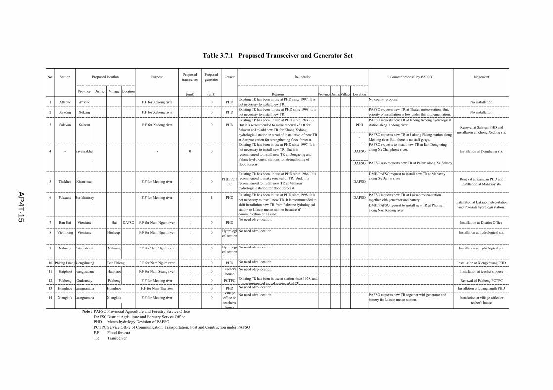
No. Station PurposeProposed
transceiverProposedgenerator
Owner Counter proposal by PAFSO Judgement
Province District Village Location(unit) (unit) Reasons ProvinceDistrictVillage Location
1 Attapue Attapue F.F for Xekong river 1 0 PHDExisting TR has been in use at PHD since 1997. It isnot necessary to install new TR.
No counter proposalNo installation
2 Xekong Xekong F.F for Xekong river 1 0 PHDExisting TR has been in use at PHD since 1998. It isnot necessary to install new TR.
PAFSO requests new TR at Thaten meteo-station. But,priority of installation is low under this implementation.
No installation
3 Salavan Salavan F.F for Xedong river 1 0 PHD PDHPAFSO requests new TR at Khong Xedong hydrologicalstation along Xedong river.
-PAFSO requests new TR at Lakong Phieng station alongMekong river, But there is no staff gauge.
4 - Savannakhet - 0 0 DAFSO
PAFSO requests to install new TR at Ban Dongheingalong Xe Chanphone river. Installation at Dongheing sta.
DAFSO PAFSO also requests new TR at Palane along Xe Saksoy
5 Thakhek Khammuan F.F for Mekong river 1 0PHD/PCT
PC
Existing TR has been in use at PHD since 1986. It isrecommended to make renewal of TR. And, it isrecommended to install new TR at Mahaxayhydrological station for flood forecast.
DAFSO
DMH/PAFSO request to install new TR at Mahaxayalong Xe Banfai river Renewal at Kamuan PHD and
installation at Mahaxay sta.
6 Pakxane Borikhamsay F.F for Mekong river 1 1 PHD DAFSOPAFSO requests new TR at Laksao meteo-stationtogether with generator and battery.
DMH/PAFSO request to install new TR at Phonsalialong Nam Kading river
7 Ban Hai Vientiane Hai DAFSO F.F for Num Ngum river 1 0 PHDNo need of re-location.
Installation at District Office
8 Vienthong Vientiane Hinheup F.F for Num Ngum river 1 0 No need of re-location. Installation at hydrological sta.
9 Naluang Saisomboun Naluang F.F for Nam Ngum river 1 0 No need of re-location. Installation at hydrological sta.
10 Phieng LuangXiengkhuang Ban Phieng F.F for Nam Ngum river 1 0 PHD No need of re-location. Installation at Xiengkhuang PHD
11 Hatphaot Luangprabang Hatphaot F.F for Nam Suang river 1 0Teacher's
houseNo need of re-location.
Installation at teacher's house
12 Pakbeng Oudomxay Pakbeng F.F for Mekong river 1 0 PCTPC Existing TR has been in use at station since 1978, andit is recommended to make renewal of TR.
Renewal of Pakbeng PCTPC
13 Hongluoy Luangnamtha Hongluoy F.F for Nam Tha river 1 0 PHD No need of re-location. Installation at Luangnamth PHD
14 Xiengkok Luangnamtha Xiengkok F.F for Mekong river 1 0No need of re-location. PAFSO requests new TR together with generator and
battery fro Laksao meteo-station.
Note : PAFSO Provincial Agriculture and Forestry Service OfficeDAFSODistrict Agriculture and Forestry Service OfficePHD Meteo-hydrology Devision of PAFSOPCTPC Service Office of Communication, Transportation, Post and Construction under PAFSOF.F Flood forecastTR Transceiver
Table 3.7.1 Proposed Transceiver and Generator Set
Re-locationProposed location
Existing TR has been in use at PHD since 1998. It isnot necessary to install new TR. It is recommended toshift installation new TR from Pakxane hydrologicalstation to Laksao meteo-station because ofcommunication of Laksao.
Existing TR has been in use at PHD since 19xx (?).But it is recommended to make renewal of TR forSalavan and to add new TR for Khong Xedonghydrological station in stead of installation of new TRat Attapue station for strengthening flood forecast.
Hydrological station
Hydrological station
Villageoffice orteacher's
house
Renewal at Salavan PHD andinstallation at Khong Xedong sta.
Installation at village office ortecher's house
Existing TR has been in use at PHD since 1997. It isnot necessary to install new TR. But it isrecommended to install new TR at Dongheing andPalane hydrological stations for strengthening offlood forecast.
Installation at Laksao meteo-stationand Phonsali hydrologu station.
AP
4T-15

No. PurposeProposedcomputer
Proposedgenerator
Owner Counter proposal Balance
Province District Village Location (unit) (unit) Reason Province District Village Location
1 Attapue PHD DL for Attapue S.S & Kenxay R.S 1 0 PHD
2 Xekong PHD DL for Chumla R.S 1 0 PHD
3 Savannakhet PHD DL for Tang Vay R.S 1 0 PHD
4 Khammuane PCTPC DL for Thakekh S.S and Hinboun R.S 1 0 PCTPC5 Borikhamsay PHD DL for Pakxan S.S, Phonsy R.S and Phamuang R.S 1 0 PHD6 Luangprabang PHD DL for Hatphaot S.S 1 0 PHD
7 Odomxay PHD DL for Pakbeng S.S and Sopchek R.S 1 0 PHD
8 Luangnamtha PHD DL for Xiengkok S.S/R.S and Hongluay S.S/R.S 1 0 PHD
9 Xaiyabuly PHD DL for Namon R.S 1 0 PHD
10 Xiengkhuang PHD DL for Phieng S.S, Nam Neun R.S and Phieng Luang 1 0 PHD
11 Vientiane PHD DL for B.Hai S.S/R.S and Vienthong S.S 1 0 PHD
12 Xumnua DMH DL for Muang Et R.S - - DMH
13 Xaisomboun DMH DL for Naluang S.S - - DMH
Note : PAFSO Provincial Agriculture and Forestry Service OfficeDAFSO District Agriculture and Forestry Service OfficePHD Meteo-hydrology Devision of PAFSOPCTPC Service Office of Communication, Transportation, Post and Construction under PAFSOF.F Flood forecastTR Transceiver
Proposed location Re-location
Table 3.7.2 Proposed Computer and Generator Set
AP
4T-1
6
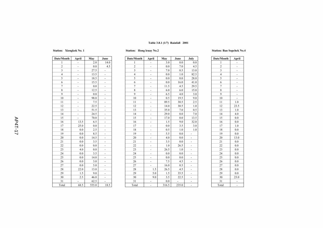
Station: Xiengkok No. 1 Station: Hong leuay No.2 Station: Ban Sopchek No.4
Date/Month April May June Date/Month April May June July Date/Month April1 - 2.0 14.0 1 - 3.0 0.0 0.0 1 -2 - 0.0 4.5 2 - 0.0 7.0 4.5 2 -3 - 27.5 - 3 - 7.0 0.5 13.0 3 -4 - 13.5 - 4 - 0.0 1.0 82.5 4 -5 - 18.5 - 5 - 0.0 0.0 28.0 5 -6 - 15.5 - 6 - 0.0 16.0 41.0 6 -7 - 0.0 - 7 - 11.5 4.5 29.5 7 -8 - 12.5 - 8 - 6.0 6.0 15.0 8 -9 - 0.0 - 9 - 6.5 4.0 3.0 9 -10 - 98.0 - 10 - 0.5 19.5 9.0 10 -11 - 7.5 - 11 - 89.5 30.5 2.5 11 1.012 - 22.5 - 12 - 14.0 30.5 1.0 12 23.513 - 51.5 - 13 - 35.0 7.0 0.5 13 1.014 - 24.5 - 14 - 29.0 0.0 7.0 14 4.015 - 70.0 - 15 - 17.0 0.0 13.5 15 0.016 13.5 6.5 - 16 - 1.5 9.0 32.0 16 0.017 25.0 0.0 - 17 - 0.0 3.5 3.0 17 1.018 0.0 2.5 - 18 - 0.5 1.0 1.0 18 0.019 0.0 8.5 - 19 - 5.5 0.0 - 19 0.020 0.0 14.5 - 20 - 4.0 0.0 - 20 13.021 0.0 3.5 - 21 - 3.5 0.0 - 21 0.022 0.0 0.0 - 22 - 1.0 26.5 - 22 0.023 4.0 0.0 - 23 - 26.5 1.0 - 23 0.024 0.0 3.5 - 24 - 0.0 0.0 - 24 0.025 0.0 14.0 - 25 - 0.0 0.0 - 25 0.026 0.0 3.0 - 26 - 7.5 4.5 - 26 0.027 0.0 5.0 - 27 - 16.0 0.5 - 27 0.028 22.0 13.0 - 28 1.5 26.5 4.5 - 28 0.029 1.5 9.0 - 29 5.0 1.5 35.5 - 29 0.030 2.5 46.0 - 30 9.0 3.5 22.5 - 30 23.031 - 62.5 - 31 - 0.0 - - 31 -
Total 68.5 555.0 18.5 Total - 316.5 235.0 - Total -
Table 3.8.1 (1/7) Rainfall 2001
AP
4T-17

Station: Naluang No. 6 Station: Ban Hay No. 7 Station: Phameaun No. 8
Date/Month March April May June Date/Month May June July August Date/Month April May June July August1 - 0.0 0.0 0.5 1 - 29.5 0.0 0.0 1 - 27.0 1.5 20.0 2.52 - 0.0 19.5 0.0 2 - 32.5 2.0 47.5 2 - 26.0 0.0 0.0 32.53 - 0.0 3.5 24.0 3 - 40.0 15.0 37.5 3 - 17.5 37.5 9.0 75.54 - 0.0 10.5 63.0 4 - 0.0 29.5 3.0 4 - 0.5 7.0 50.5 0.05 - 0.0 0.5 51.0 5 - 19.5 29.0 0.5 5 - 2.0 0.5 3.0 6.06 - 0.0 1.0 1.5 6 - 1.0 0.0 12.5 6 - 7.0 7.0 1.0 8.57 - 0.0 0.0 16.5 7 - 14.0 0.0 31.0 7 - 0.0 11.5 1.0 32.58 - 0.0 0.0 26.5 8 - 18.5 11.5 2.0 8 - 0.0 9.0 4.0 10.59 - 0.0 4.0 - 9 - 7.5 70.5 32.0 9 - 0.0 3.0 12.5 2.510 - 0.0 25.0 - 10 34.5 45.0 0.0 - 10 - 56.0 34.5 13.5 -11 - 0.0 41.5 - 11 0.0 25.5 0.0 - 11 - 0.0 33.5 0.0 -12 - 5.0 58.0 - 12 0.0 24.5 0.0 - 12 - 0.0 18.0 0.0 -13 - 4.0 3.0 - 13 0.0 57.0 0.0 - 13 - 0.0 15.5 47.5 -14 - 0.0 0.0 - 14 0.0 0.0 36.5 - 14 - 0.0 0.0 19.0 -15 - 0.0 22.0 - 15 0.0 3.0 5.5 - 15 - 9.5 52.0 44.0 -16 - 0.0 1.0 - 16 0.0 3.0 0.0 - 16 - 0.0 7.5 1.5 -17 - 0.0 0.0 - 17 6.5 0.0 2.0 - 17 - 64.0 0.0 63.5 -18 - 0.0 31.5 - 18 65.0 0.0 0.0 - 18 - 25.0 5.5 4.5 -19 - 0.0 29.5 - 19 65.5 0.0 0.5 - 19 - 25.0 8.5 24.0 -20 - 0.0 24.0 - 20 30.0 0.0 14.0 - 20 - 2.0 6.5 51.0 -21 - 0.0 13.0 - 21 8.0 0.0 35.5 - 21 - 11.5 5.5 25.0 -22 - 0.0 7.0 - 22 0.5 27.0 31.0 - 22 - 1.0 2.0 26.5 -23 - 0.0 11.5 - 23 16.5 0.0 17.0 - 23 2.5 0.0 0.0 31.5 -24 - 0.0 6.5 - 24 18.5 5.5 7.0 - 24 21.0 0.0 6.5 31.5 -25 1.0 0.0 38.0 - 25 29.5 1.5 8.5 - 25 0.0 23.0 21.5 4.5 -26 0.0 0.0 27.5 - 26 4.0 0.0 59.0 - 26 2.0 40.5 0.0 40.0 -27 35.5 0.0 0.5 - 27 4.5 31.0 14.0 - 27 0.0 55.5 18.5 15.0 -28 4.0 0.0 26.0 - 28 65.5 9.0 15.5 - 28 0.0 8.5 3.0 7.5 -29 7.5 0.0 28.5 - 29 44.0 10.5 0.0 - 29 19.0 66.0 48.5 0.5 -30 0.0 0.0 20.0 - 30 36.0 18.5 0.0 - 30 0.0 21.0 26.0 0.0 -31 0.0 - 26.5 - 31 27.0 - 9.0 - 31 - 27.5 - 0.5 -
Total - 9.0 479.5 - Total - 423.5 412.5 - Total - 516.0 390.0 552.0 -
Table 3.8.1 (2/7) Rainfall 2001

Station: Ban Phiengdang No.15 (Nam Neun), Station: Chunla No. 12 Station: Ban Pakhinboune No. 9Xiengkhouang Province.Date/Month April May June July Date/Month April May June July Date/Month April May June July August
1 - 0.0 26.0 0.5 1 - 0.0 0.0 0.5 1 - 3.0 0.0 41.5 20.52 - 5.0 7.0 0.0 2 - 0.0 1.0 3.0 2 - 8.5 16.0 16.0 19.03 - 9.5 1.0 4.0 3 - 2.5 0.0 0.0 3 - 4.0 3.5 23.5 57.04 - 0.0 1.5 22.5 4 - 0.0 21.5 13.5 4 - 32.0 0.0 1.5 12.55 - 0.0 9.5 0.0 5 - 7.5 0.5 5.5 5 - 0.0 60.0 12.5 5.06 - 0.0 2.0 0.0 6 - 0.0 12.0 4.5 6 - 0.0 25.0 35.0 9.07 - 0.0 0.0 0.0 7 - 0.0 15.0 16.0 7 - 0.0 0.0 1.5 6.08 - 0.0 0.0 3.5 8 - 0.0 2.0 139.5 8 - 0.0 56.5 65.0 27.09 - 0.0 7.5 12.0 9 - 0.5 4.5 10.5 9 - 0.0 12.5 2.0 133.010 - 10.0 3.0 0.0 10 - 4.0 21.5 2.5 10 - 6.0 16.0 1.5 0.511 - 0.0 2.5 0.0 11 - 1.0 2.0 0.5 11 - 0.5 8.0 0.5 -12 - 0.0 3.5 0.0 12 - 49.0 0.0 0.5 12 - 0.0 42.5 6.0 -13 - 0.0 53.0 0.0 13 - 40.0 0.0 4.5 13 - 0.0 2.0 31.0 -14 - 0.0 0.0 0.5 14 - 6.5 11.0 - 14 - 0.0 48.0 2.0 -15 - 0.0 0.0 1.0 15 - 0.5 2.5 - 15 - 3.0 18.0 7.0 -16 - 0.0 1.0 5.5 16 - 23.0 22.0 - 16 - 1.5 24.5 23.5 -17 - 0.0 0.0 30.5 17 - 25.0 3.0 - 17 - 1.0 3.5 1.0 -18 - 16.0 0.0 0.0 18 8.0 4.5 4.0 - 18 - 20.0 0.0 1.0 -19 - 31.5 0.0 37.0 19 0.0 0.5 0.0 - 19 - 58.0 0.0 0.0 -20 - 52.0 0.0 1.0 20 8.5 1.0 0.0 - 20 - 20.0 0.0 35.0 -21 - 13.5 1.5 0.5 21 6.0 0.0 10.0 - 21 - 7.0 0.0 117.0 -22 - 0.0 0.0 9.5 22 0.0 0.0 0.0 - 22 - 31.5 1.5 17.0 -23 - 0.0 0.0 43.5 23 0.0 0.0 23.0 - 23 - 6.0 5.5 0.0 -24 3 2.0 0.5 10.0 24 0.0 0.0 30.0 - 24 - 5.5 23.5 0.0 -25 2 0.0 0.5 2.0 25 0.0 9.5 14.5 - 25 - 32.5 3.5 0.0 -26 0 9.0 0.0 - 26 0.0 36.5 7.0 - 26 - 3.5 5.0 32.0 -27 10.5 0.0 10.0 - 27 0.0 3.0 4.5 - 27 - 1.0 5.0 37.5 -28 0 30.0 19.0 - 28 0.0 1.5 22.0 - 28 - 48.5 24.0 10.5 -29 16.5 2.5 13.5 - 29 0.0 5.0 33.0 - 29 - 55.5 13.5 2.0 -30 0 21.0 2.0 - 30 0.0 18.5 5.5 - 30 4.0 0.0 72.0 38.5 -31 - 31.5 - - 31 - 0.0 - - 31 - 29.0 - 8.5 -
Total - 233.5 164.5 - Total - 239.5 272.0 - Total - 377.5 489.5 570.0 -
Table 3.8.1 (3/7) Rainfall 2001

Station: Ban Phonsy No. 10 Station: Kengxay No. 14
Date/Month April May June July August Date/Month April May June July August1 - 73.0 0.0 0.5 5.5 1 - 1.5 0.0 0.0 0.02 - 1.5 5.0 24.5 36.0 2 - 0.0 3.0 0.0 0.03 - 2.0 61.5 82.5 20.5 3 - 0.0 0.0 0.0 0.04 - 45.0 20.5 113.5 - 4 - 0.0 7.5 11.0 1.55 - 0.5 24.0 2.0 - 5 - 0.0 3.0 37.0 1.56 - 0.0 26.5 53.0 - 6 - 0.0 1.0 25.5 14.07 - 0.0 14.0 19.0 - 7 - 0.0 3.5 49.0 11.08 - 0.0 1.0 1.0 - 8 - 4.5 20.0 22.0 17.59 - 0.0 3.0 63.5 - 9 - 0.0 0.0 2.0 34.0
10 - 24.0 65.5 14.5 - 10 - 10.0 5.0 0.0 42.511 - 0.0 59.0 0.0 - 11 - 3.5 0.5 2.0 28.012 - 0.0 112.5 14.0 - 12 - 90.0 0.0 0.0 -13 - 0.0 122.5 11.5 - 13 - 58.5 0.0 0.0 -14 1.5 0.0 7.0 17.0 - 14 - 44.5 21.0 0.0 -15 0.0 7.0 0.0 48.0 - 15 - 0.0 4.0 2.0 -16 0.0 0.0 42.5 50.0 - 16 - 26.0 19.0 0.0 -17 16.0 4.0 1.0 38.0 - 17 - 10.5 0.0 0.0 -18 0.0 22.5 8.0 0.5 - 18 - 0.0 1.0 6.5 -19 0.0 13.5 0.0 21.0 - 19 - 9.5 2.0 0.0 -20 0.0 14.5 0.0 24.5 - 20 28.5 0.0 4.0 53.5 -21 0.0 77.5 1.5 42.5 - 21 0.0 0.0 4.0 6.5 -22 0.0 2.5 0.0 23.0 - 22 0.0 0.0 10.5 1.5 -23 0.0 74.5 5.0 2.5 - 23 0.0 0.5 12.5 0.0 -24 27.5 47.0 27.5 10.0 - 24 0.0 0.0 44.5 0.5 -25 0.0 1.5 15.5 32.5 - 25 0.0 0.0 2.0 8.5 -26 0.0 6.5 46.5 20.0 - 26 0.0 2.0 2.5 2.5 -27 0.0 7.5 99.0 40.5 - 27 2.0 1.0 3.0 3.5 -28 0.0 27.5 53.5 12.5 - 28 0.0 5.0 6.5 1.5 -29 16.5 39.5 34.0 6.5 - 29 15.0 0.5 7.5 0.5 -30 0.0 58.0 28.0 0.0 - 30 0.0 0.0 19.5 0.0 -31 - 28.0 - 26.0 - 31 - 0.0 - 1.0 -
Total - 577.5 884.0 814.5 - Total - 267.5 207.0 236.5 -
Table 3.8.1(4/7) Rainfall 2001
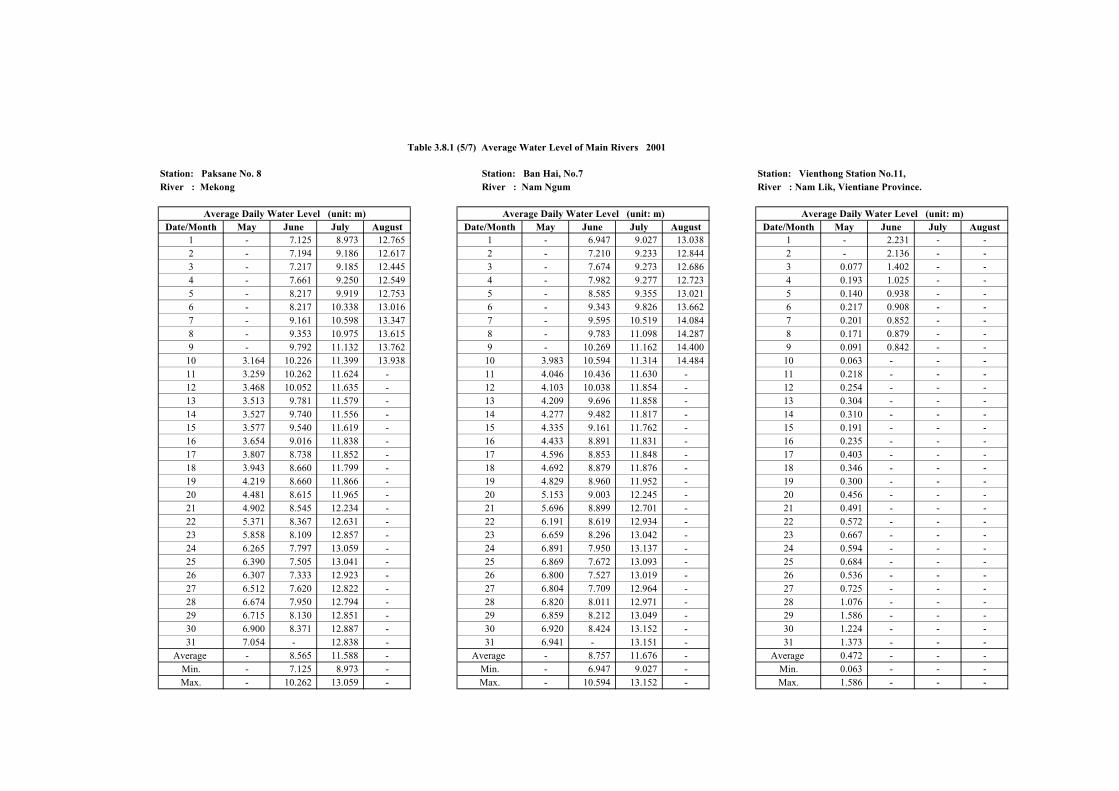
Station: Paksane No. 8 Station: Ban Hai, No.7 Station: Vienthong Station No.11, River : Mekong River : Nam Ngum River : Nam Lik, Vientiane Province.
Date/Month May June July August Date/Month May June July August Date/Month May June July August1 - 7.125 8.973 12.765 1 - 6.947 9.027 13.038 1 - 2.231 - -
2 - 7.194 9.186 12.617 2 - 7.210 9.233 12.844 2 - 2.136 - -
3 - 7.217 9.185 12.445 3 - 7.674 9.273 12.686 3 0.077 1.402 - -
4 - 7.661 9.250 12.549 4 - 7.982 9.277 12.723 4 0.193 1.025 - -
5 - 8.217 9.919 12.753 5 - 8.585 9.355 13.021 5 0.140 0.938 - -
6 - 8.217 10.338 13.016 6 - 9.343 9.826 13.662 6 0.217 0.908 - -
7 - 9.161 10.598 13.347 7 - 9.595 10.519 14.084 7 0.201 0.852 - -
8 - 9.353 10.975 13.615 8 - 9.783 11.098 14.287 8 0.171 0.879 - -
9 - 9.792 11.132 13.762 9 - 10.269 11.162 14.400 9 0.091 0.842 - -
10 3.164 10.226 11.399 13.938 10 3.983 10.594 11.314 14.484 10 0.063 - - -
11 3.259 10.262 11.624 - 11 4.046 10.436 11.630 - 11 0.218 - - -
12 3.468 10.052 11.635 - 12 4.103 10.038 11.854 - 12 0.254 - - -
13 3.513 9.781 11.579 - 13 4.209 9.696 11.858 - 13 0.304 - - -
14 3.527 9.740 11.556 - 14 4.277 9.482 11.817 - 14 0.310 - - -
15 3.577 9.540 11.619 - 15 4.335 9.161 11.762 - 15 0.191 - - -
16 3.654 9.016 11.838 - 16 4.433 8.891 11.831 - 16 0.235 - - -
17 3.807 8.738 11.852 - 17 4.596 8.853 11.848 - 17 0.403 - - -
18 3.943 8.660 11.799 - 18 4.692 8.879 11.876 - 18 0.346 - - -
19 4.219 8.660 11.866 - 19 4.829 8.960 11.952 - 19 0.300 - - -
20 4.481 8.615 11.965 - 20 5.153 9.003 12.245 - 20 0.456 - - -
21 4.902 8.545 12.234 - 21 5.696 8.899 12.701 - 21 0.491 - - -
22 5.371 8.367 12.631 - 22 6.191 8.619 12.934 - 22 0.572 - - -
23 5.858 8.109 12.857 - 23 6.659 8.296 13.042 - 23 0.667 - - -
24 6.265 7.797 13.059 - 24 6.891 7.950 13.137 - 24 0.594 - - -
25 6.390 7.505 13.041 - 25 6.869 7.672 13.093 - 25 0.684 - - -
26 6.307 7.333 12.923 - 26 6.800 7.527 13.019 - 26 0.536 - - -
27 6.512 7.620 12.822 - 27 6.804 7.709 12.964 - 27 0.725 - - -
28 6.674 7.950 12.794 - 28 6.820 8.011 12.971 - 28 1.076 - - -
29 6.715 8.130 12.851 - 29 6.859 8.212 13.049 - 29 1.586 - - -
30 6.900 8.371 12.887 - 30 6.920 8.424 13.152 - 30 1.224 - - -
31 7.054 - 12.838 - 31 6.941 - 13.151 - 31 1.373 - - -
Average - 8.565 11.588 - Average - 8.757 11.676 - Average 0.472 - - -
Min. - 7.125 8.973 - Min. - 6.947 9.027 - Min. 0.063 - - -
Max. - 10.262 13.059 - Max. - 10.594 13.152 - Max. 1.586 - - -
Table 3.8.1 (5/7) Average Water Level of Main Rivers 2001
Average Daily Water Level (unit: m) Average Daily Water Level (unit: m) Average Daily Water Level (unit: m)

Station: Ban Naluang No. 6 Station: Ban Phieng Luang, No.5 Station: Hong Leuay, No.2River : Nam Ngum River : Nam Ngum River : Nam Tha
Average Daily Water Level (unit: m)Date/Month April May June Date/Month April May June Date/Month April May June
1 - 0.136 1.780 1 - 0.400 0.948 1 - - -2 - 0.132 1.783 2 - 0.417 0.781 2 - - -3 - 0.277 1.404 3 - 0.562 0.673 3 - - -4 - 0.346 1.288 4 - 0.668 0.610 4 - - -5 - 0.362 1.369 5 - 0.616 0.576 5 - - -6 - 0.377 1.292 6 - 0.562 0.553 6 - - -7 - 0.303 1.226 7 - 0.501 - 7 - - -8 - 0.256 1.341 8 - 0.505 - 8 - - -9 - 0.219 1.381 9 - 0.467 - 9 0.036 - -10 - 0.205 - 10 - 0.442 - 10 0.033 - -11 - 0.373 - 11 - 0.453 - 11 0.030 - -12 - 0.535 - 12 - 0.563 - 12 0.027 - -13 - 1.076 - 13 - 0.485 - 13 0.026 - -14 - 0.621 - 14 - 0.446 - 14 0.043 - -15 - 0.488 - 15 - 0.422 - 15 0.050 - -16 - 0.507 - 16 - 0.434 - 16 0.033 - -17 - 0.545 - 17 - 0.417 - 17 0.004 - -18 - 0.438 - 18 - 0.402 - 18 0.030 - -19 - 0.459 - 19 - 0.524 - 19 0.029 - -20 - 0.684 - 20 - 0.524 - 20 0.018 - -21 - 1.057 - 21 - 0.747 - 21 0.011 - -22 - 1.051 - 22 - 0.646 - 22 0.004 - -23 0.181 0.985 - 23 - 1.041 - 23 (0.001) - -24 0.168 1.140 - 24 0.384 0.745 - 24 0.001 - -25 0.157 0.997 - 25 0.382 0.654 - 25 0.004 - -26 0.154 1.158 - 26 0.424 0.665 - 26 (0.001) - -27 0.148 1.639 - 27 0.498 0.755 - 27 0.003 - -28 0.152 1.657 - 28 0.457 0.787 - 28 - - -29 0.161 1.527 - 29 0.414 0.916 - 29 - - -30 0.152 1.415 - 30 0.393 0.978 - 30 - - -31 - 1.509 - 31 - 0.940 - 31 - - -
Average - 0.725 - Average - 0.603 - Average - - -Min. - 0.132 - Min. - 0.400 - Min. - - -Max. - 1.657 - Max. - 1.041 - Max. - - -
Table 3.8.1 (6/7) Water Level of Main Rivers 2001
Average Daily Water Level (unit: m) Average Daily Water Level (unit: m)

Station: Attapeu No. 10River : Xekong
Date/Month April May June July1 - 0.002 0.135 2.5262 - 0.004 0.095 2.4773 - 0.111 0.128 3.0684 - 0.086 0.593 3.8525 - 0.070 0.562 4.4066 - 0.030 0.482 4.4827 - 0.018 0.473 6.0108 - 0.018 0.411 7.4839 - -0.005 0.136 6.17310 - -0.002 0.158 4.54311 - -0.002 0.321 3.60812 - 0.100 0.340 -13 - 0.611 0.297 -14 - 1.212 0.501 -15 - 1.260 0.918 -16 - 0.852 2.311 -17 - 1.821 1.935 -18 - 1.884 1.328 -19 - 1.377 1.021 -20 - 1.070 1.447 -21 - 0.745 1.185 -22 - 0.548 2.473 -23 - 0.418 1.775 -24 - 0.374 2.329 -25 - 0.326 2.928 -26 - 0.304 2.510 -27 - 0.464 2.474 -28 0.000 0.402 2.513 -29 0.005 0.541 2.811 -30 0.007 0.374 2.698 -31 - 0.138 - -
Average - 0.489 1.243 -Min. - -0.005 0.095 -Max. - 1.884 2.928 -
Average Daily Water Level (unit: m)
Table 3.8.1 (7/7) Water Level of Main Rivers 2001

No. River basin /Catchment area Basin Area (km2) Rainfall station Available data Drought year (T-1/5) Hydrological stationCatchment area of
Station (Km2)Available data
1 Nam Ma 6 059 non non2 Nam Pha 2 860 non non3 Nam Kha 1 110 non non4 Nam Ngam 1 500 non non5 Nam Tha 8 990 Luang Nam Tha 1993-1999 1997 non6 Nam Beng 2 120 non non7 Nam Ou 24 470 Phongsali 1990-1999 1999 *1 Muang Ngoy 19 700 1978(87) ?-2000 (N.A)
Oudomxai 1991-1999 1999Mouan Ngoy, Luangprabang 1992-1999 (1998)/1999*
8 Nam Xuang 5 800 non *1 Xiboun Heung 5 800 1967-1972, 1974-1979, 987-2000 (N.A)*1 Kok Vane 700 1981(88)?-2000 (N.A)
9 Nam Khan 6 770 Luangprabang 1950-1999 1998 *1 Pak Bak 6 503 1985-2000 (N.A)Xieng Ngeun, Luangprabang 1992-1999 1992*/(1995) *1 Moud (Mixay) 6 777 1960-2000 (N.A)
10 Nam Ngum, Sayabouly Pro. 1 830 non non11 Nam Houng 2 940 Sayabouly 1965-1999 1997 non12 Nam Pouly 1 700 non non13 Nam Phoun 1 980 non non14 Nam Heung 1 940 non non15 Nam Mi 1 040 non non16 Nam Sang 1 300 non non17 Nam Thon 553 non non18 Nam Et non non19 Nam Xan 4 328 non *1 Nong Muang 441 1996- ?? (N.A)20 Nam Luong Vian Xai, Xam Nua Pro. 1994-1999 1998 non21 Nam Neun 3 732 non non22 Nam Mat 2 052 non non23 Nam Mo 1 728 non non24 Nam Lik 4 980 Kasy 1969-1976, 1988-1998 1993 Kasy 374 1988-1989, 1992-1994, 1996-1999 (P.A)
Hineheup 1968-1976, 1982-1999 (1993)/1996* Hienheup 5 115 1963-1975, 1981, 1983-1999 (P.A)Thalat 1980-1998 (1987)/1998* Vangvieng 864 1987-1995, 1997-1999Phatang 1997 N.A because of dataVangvieng 1972-1999 1982
25 Upper Nam Ngum Xieng Khouang 1982-1999 1993*/(1998) Naluang 4 852 1987-1989, 1990-1999 (P.A)Naluang 1987-1999 (1988)/1993*
26 Lower Nam Ngum 16 790 Pakkagnoung 1965-1968, 1970-1976, 1989-1999 1968 Pakkanhoung 13 560 1991-1999Napheng 1971-1999 1980 *1 Tha Lat 8 280 1966-1983, 1985-1988 (N.A)Veunkha, Vientiane Munincipality 1990-1998 1990 *1 Tha Ngone 1961-1985, 1987-1988 (N.A)Tha Ngon 1971-1995 (1983)/1988*Naphok 1997-1999 N.A because of dataVientiane 1951-2000 (1993)/1998*
27 Nam Mang 1 860 Tadluek 1991-1999 1995 *1 Tat Luek 542 1991-1996, 1997-2000 ?(N.A)*1 Hatk Hai 743 1991-1993 ? (N.A)
28 Nam Ngiep 4 305 Muang Mai 1978-1979, 1988-1999 1989 Muang Mai 4 305 1991-1999Note: (1992)/1998* * The nearest hydrological year to the statistic value
( ) The second nearest hydrological year to the statistic valueN.A : Not available P.A : Partially available
*1 Hydrological data was not found out due to data complation problems of DMH during the Study
Table 4.1.1 Hydrological Stations and Available Data (1/2)

No. River basin /Catchment area Basin Area (km2) Rainfall station Available data Drought year (T-1/5) Hydrological stationCatchment area of
Station (Km2)Available data
29 Nam Xane 2 029 Muang Kao 1978-1979, 1985-1999 1990 Muang Kao 2 029 1987-1999 (P.A)Paksane 1990-1999 1995
30 Nam Kading 14 175 Signo 1992-1999 1993*/(1999) Signo 3 370 1986-2000 (P.A)Nape 1988-1999 (1994)/1999* *1 Keng Kuang 5 650 1985-1986, 1990-1993 (N.A)Keng Kuang 1985-1987, 1990 N.A because of data *1 Phone Sy 14 175 1960, 1984- (N.A)
31 Nam Thon 797 non non32 Nam Hinboun 3 380 non non33 Nam Don 674 Thakhek 1987-1999 1992 non34 Xe Banfai 9 330 Kuan Pho 1994-1995, 1997-1999 N.A because of data Mahaxay 4 520 1988-1993, 1994-1997, 1999 (P.A)
Mahaxay 1993-1999 1993 *1 Highway Bridge(Xe Banfai) 8 560 1960-1985, 1994-2000 (N.A)Veune, Savannakhet 1989-1999 (1993)/1995*
35 Nam Thahao 692 non non36 Houy Sompoy 448 Savannakhet 1971-1999 1983*/(1988) non
Seno 1961-1999 198337 Xe Bang Hiang 9 330 Muang Nong 1989-1999 (1993)/1994* *1 Keng Kok 2 733 1978-1984, 1987-2000 (N.A)
Dong 1988-1999 1993 *1 Dong Hen 1 525 1990, 1993-2000 (N.A)Xepon *1 Highway Bridge(Xe Thamouak 608 1990-1991, 1993-2000 (N.A)Muang Phine 1988-1999 (1988)/1993* *1 Muang Nong 2 011 1990-2000 (N.A)Phalane 1990-1997 1994 *1 Sopnam (Rsepol) 4 362 1988-2000 (N.A)Donghen 1988-1999 (1988)/1993* *1 Keng Done 19 400 1960-1979, 1988-2000 (N.A)Kengkok 1988-1999 1998 *1 Phalane 892 1990-2000 (N.A)Kengdone 1993-1997 1993
38 Xe Bangnouan 1 420 Xenuan 1987-1997 1995 non39 Xe Done 7 320 Salavan 1981-1984, 1990-1999 1993 Souvanakhily 5 760 1986-1994, 1996-1999 (P.A)
Laongam 1991-1992, 1994-1999 1997 *1 Itou Km35 54 1996-2000 (N.A)Khongsedone 1988-1999 (1988)/1989* *1 Saravan 1 172 1989-1992, 1994-1996 (N.A)Xelabam 1988-1999 1993 *1 Kong Xedone 5 152 1989-1990, 1992, 1996-1999 (N.A)Nonghine 1993-1999 1995Bachian 1991-1999 1993Pakxong 1992-1999 (1993)/1995*Pakse 1951-2000 1988*/(1990/1995)
40 Houy Phaling 469 Phonthong 1993-1995 N.A because of data non41 Houy Khannouan 1 620 Soukhouna 1993-1999 1998 *1 Mai Vang Makxeo 1995-2000 (N.A)42 Houy Kadian Mounlapamok 1965-1970, 1979-1999 1969*/(1983/1993) non43 Nam Lepou 1 540 non non44 Houy Banglieng 508 non *1 Banglieng 460 1994-2000 (N.A)45 Houy Touay 370 non non46 Houy Tomo 153 Pathoumphone 1979-1986, 1993-1999 1983 *1 Tomo Km 40 130 1994-2000 (N.A)47 Xe Kong 22 960 Nikhom 34 1990-1999 (1990)/1993* *1 PhoneM. Lamam 5 539 1994-2000 (N.A)
Xe Kong 1994-1999 N.A because of data Attapeu 10 500 1989-1996, 1998-2000 (P.A)Km 42 1990-1999 (1993)/1995* *1 Saphao 15 641 1999-2000 (N.A)Attapeu 1989-1999 (1992)/1999* *1 Phang Deng 4 454 1991-2000 (N.A)
1999Note: (1992)/1998* * The nearest hydrological year to the statistic value
( ) The second nearest hydrological year to the statistic valueN.A : Not available P.A : Partially available
*1 Hydrological data was not found out due to data complation problems of DMH during the Study
Table 4.1.1 Hydrological Stations and Available Data(2/2)

No. River Basin Rain Gauge Station Year Jan. Feb. Mar. Apr. May Jun. Jul. Aug. Sept. Oct. Nov. Dec. Annual
1 Nam Ma non2 Nam Pha non3 Nam Kha non4 Nam Ngam non5 Nam Tha Luang Nam Tha 1999 50 0 6 43 374 167 260 253 177 104 72 38 1,5426 Nam Beng non7 Nam Ou Phongsali 1996 0 46 24 51 165 208 426 399 156 79 40 62 1,655
Oudomxai 1998 28 57 146 143 291 237 221 190 43 20 9 1,384Mouan Ngoy, Luangprabang 1995 0 1 14 14 79 401 281 252 94 178 60 0 1,374
8 Nam Xuang non9 Nam Khan Luangprabang 1999 9 0 44 60 204 281 74 285 198 98 55 45 1,351
Xieng Ngeun, Luangprabang (1994)/1999* 3 0 33 114 276 260 113 138 184 87 33 0 1,24010 Nam Ngum, Sayabouly Pro. non11 Nam Houng Sayabouly 1996 0 13 54 124 48 208 212 256 252 68 58 0 1,29312 Nam Pouly non13 Nam Phoun non14 Nam Heung non15 Nam Mi non16 Nam Sang non17 Nam Thon non18 Nam Et non19 Nam Xan non20 Nam Luong Vian Xai, Xam Nua Pro. 1999 4 3 50 161 367 283 167 496 152 72 54 59 1,86721 Nam Neun non22 Nam Mat non23 Nam Mo non24 Nam Lik Kasy (1994)/1995* 0 0 63 98 259 483 425 350 255 84 40 0 2,055
Hineheup 1994 0 0 75 70 364 244 186 345 258 101 1 0 1,643Thalat (1988)/1996* 0 19 51 300 87 344 253 416 231 131 0 0 1,830PhatangVangvieng 1998 0 16 47 239 288 459 780 682 457 102 65 5 3,140
25 Upper Nam Ngum Xieng Khouang 1999 5 0 54 117 212 209 147 407 125 46 23 17 1,363Naluang 1999 8 0 77 207 598 491 481 318 318 60 0 0 2,559
26 Lower Nam Ngum Pakkagnoung 1994 0 4 109 5 458 266 379 459 296 85 21 24 2,105Napheng 1996 0 63 68 80 84 351 478 646 380 61 181 0 2,391Veunkham, Vientiane Municipality 1996 3 47 119 176 182 298 244 306 436 89 82 0 1,980Tha Ngon 1985 20 32 31 57 191 491 360 214 250 170 2 0 1,818NaphokVientiane 1986*/(1987) 0 3 2 119 383 256 309 318 275 67 0 21 1,753
27 Nam Mang Tadluek 1998 0 49 64 140 432 385 509 662 576 175 0 0 2,99228 Nam Ngiep Muang Mai 1990 14 61 145 123 620 884 990 628 381 55 14 0 3,916
Note: (1992)/1998* * The nearest hydrological year to the statistic value( ) The second nearest hydrological year to the statistic value
Table 4.1.2 Mean Monthly Rainfall in Ordinary Hydrological Year (1/2)

No. River Basin Rain Gauge Station Year Jan. Feb. Mar. Apr. May Jun. Jul. Aug. Sept. Oct. Nov. Dec. Annual
29 Nam Xane Muang Kao 1994 0 88 108 61 288 756 656 613 272 52 0 14 2,908Paksane 1992 0 0 1 51 97 153 416 793 792 486 303 59 3,153
30 Nam Kading Signo 1995 0 9 32 78 374 607 483 574 224 188 8 0 2,577Nape 1993 0 22 21 133 336 307 261 523 142 6 47 0 1,797Keng Kuang
31 Nam Thon non32 Nam Hinboun non33 Nam Don Thakhek 1994 0 61 95 56 170 709 512 428 243 41 1 0 2,31534 Xe Banfai Kuan Pho
Mahaxay 1997 1 24 65 65 238 395 691 721 389 96 0 0 2,683Veune, Savannakhet 1994 0 70 25 55 137 422 293 488 125 18 0 0 1,633
35 Nam Thahao non36 Houy Sompoy Savannakhet (1987)/1991* 0 0 13 5 95 251 168 403 401 169 0 34 1,539
Seno 1994 0 53 32 97 207 194 120 455 193 20 0 0 1,37037 Xe Bang Hiang Muang Nong 1997 7 18 37 206 115 169 198 516 191 67 2 5 1,531
Dong 1991 0 0 24 8 262 293 326 526 117 211 0 35 1,801XeponMuang Phine 1991 0 0 11 53 241 248 428 594 422 155 0 37 2,188Phalane 1997 1 29 125 145 89 150 236 835 109 96 0 0 1,814Donghen 1994 0 66 36 99 259 478 214 402 199 22 0 0 1,775Kengkok 1995 0 30 42 26 147 168 544 267 115 94 6 0 1,440Kengdone 1995 0 11 20 26 141 295 294 307 240 56 30 0 1,419
38 Xe Bangnouan Xenuan 1997 25 61 84 72 397 131 512 293 58 66 0 0 1,69739 Xe Done Salavan 1997 12 49 22 140 260 309 418 514 169 41 0 0 1,933
Laongam 1992 55 6 0 59 214 435 331 553 333 97 0 0 2,082Khongsedone 1999 1 0 75 181 397 281 337 179 242 107 47 1 1,847Xelabam 1996 0 12 5 169 388 163 287 292 604 130 28 0 2,077Nonghine 1999 96 0 120 264 276 363 640 451 218 223 81 0 2,733Bachian 1996 0 39 1 129 327 218 351 428 712 174 0 0 2,380Pakxong 1997 4 79 108 320 248 499 1,085 890 317 131 58 35 3,773Pakse 1987 0 0 14 59 139 430 663 552 167 60 28 0 2,112
40 Houy Phaling Phonthong41 Houy Khannouan Soukhouna 1994 0 0 62 58 202 281 376 304 658 93 0 2 2,03542 Houy Kadian Mounlapamok 1996 0 0 1 148 316 345 231 225 263 122 196 0 1,84743 Nam Lepou non44 Houy Banglieng non45 Houy Touay non46 Houy Tomo Pathoumphone 1994 0 0 62 58 202 281 376 304 658 93 0 2 2,03447 Xe Kong Nikhom 34 1994 2 4 224 195 272 507 1,095 430 638 219 33 50 3,668
Xe KongKm 42 1994 2 4 224 195 272 507 1,095 430 638 219 33 50 3,668Attapeu 1999 2 0 22 417 227 354 601 460 301 140 45 1 2,569Note: (1992)/1998* * The nearest hydrological year to the statistic value
( ) The second nearest hydrological year to the statistic value
Table 4.1.2 Mean Monthly Rainfall in Ordinary Hydrological Year (2/2)

No. River Basin Rain StationProbable Drought Year
T=5 Jan. Feb. Mar. Apr. May Jun. Jul. Aug. Sept. Oct. Nov. Dec. Annual
1 Nam Ma non2 Nam Pha non3 Nam Kha non4 Nam Ngam non5 Nam Tha Luang Nam Tha 1997 2 2 66 59 52 72 386 362 221 111 57 15 1,4066 Nam Beng non7 Nam Ou Phongsali 1999 53 31 18 186 268 170 20 463 124 82 46 44 1,505
Oudomxai 1999 24 9 40 142 138 151 119 192 192 77 39 34 1,154
Mouan Ngoy, Luangprabang (1998)/1999* 3 1 22 63 69 239 170 346 104 9 2 0 1,0298 Nam Xuang non9 Nam Khan Luangprabang 1998 27 2 33 178 161 138 179 265 99 47 26 8 1,164
Xieng Ngeun, Luangprabang 1992*/(1995) 41 64 0 38 112 32 271 158 89 36 12 98 95110 Nam Ngum, Sayabouly Pro. non11 Nam Houng Sayabouly 1997 0 0 93 98 100 44 231 154 222 78 83 0 1,10212 Nam Pouly non13 Nam Phoun non14 Nam Heung non15 Nam Mi non16 Nam Sang non17 Nam Thon non18 Nam Et non19 Nam Xan non20 Nam Luong Vian Xai, Xam Nua Pro. 1998 6 7 33 128 216 148 148 343 272 45 16 10 1,37221 Nam Neun non22 Nam Mat non23 Nam Mo non24 Nam Lik Kasy 1993 0 0 83 97 342 283 372 338 204 143 0 0 1,861
Hineheup (1993)/1996* 2 14 42 112 93 219 160 299 215 86 41 0 1,284
Thalat (1987)/1998* 0 0 22 14 225 189 339 344 202 52 9 0 1,395PhatangVangvieng 1982 0 1 36 142 342 407 534 703 653 51 35 0 2,904
25 Upper Nam Ngum Xieng Khouang 1993*/(1998) 0 1 20 98 220 227 331 217 89 11 0 6 1,219
Naluang (1988)/1993* 0 11 0 74 193 647 548 277 156 18 0 0 1,92326 Lower Nam Ngum Pakkagnoung 1968 3 14 17 71 374 335 158 259 416 42 45 0 1,735
Napheng 1980 0 13 4 20 323 290 369 373 484 7 0 0 1,883Veunkham, Vientiane Municipality 1990 0 20 33 46 331 224 171 239 369 32 23 0 1,488
Tha Ngon (1983)/1988* 0 23 33 85 289 154 182 403 105 177 83 0 1,534Naphok
Vientiane (1993)/1998* 0 8 35 79 144 278 304 393 186 46 6 1 1,47727 Nam Mang Tadluek 1995 5 5 18 195 175 668 627 643 9 55 0 0 2,39928 Nam Ngiep Muang Mai 1989 0 0 8 82 350 970 511 717 303 116 0 0 3,057
Note: (1992)/1998* * The nearest hydrological year to the statistic value( ) The second nearest hydrological year to the statistic value
Table 4.1.3 Drought Rainfall (Point Rainfall) T=5 years (1/2)

No. River Basin Rain StationProbable Drought Year
T=5 Jan. Feb. Mar. Apr. May Jun. Jul. Aug. Sept. Oct. Nov. Dec. Annual
29 Nam Xane Muang Kao 1990 5 17 66 133 533 465 568 472 209 104 69 0 2,640Paksane 1995 3 20 0 10 0 177 392 644 621 215 500 0 2,581
30 Nam Kading Signo 1993*/(1999) 7 38 7 52 479 580 452 444 25 0 0 0 2,082
Nape (1994)/1999* 0 0 102 80 331 161 274 122 125 163 40 0 1,398Keng Kuang
31 Nam Thon non32 Nam Hinboun non33 Nam Don Thakhek 1992 11 32 13 46 214 298 462 460 338 43 0 85 1,99934 Xe Banfai Kuan Pho
Mahaxay 1993 7 38 7 52 479 580 452 444 25 0 0 0 2,082
Veune, Savannakhet (1993)/1995* 0 0 63 139 255 138 302 313 141 0 0 0 1,34935 Nam Thahao non
36 Houy Sompoy Savannakhet 1983*/(1988) 5 1 0 78 156 287 67 403 146 177 0 0 1,321Seno 1983 3 1 1 23 35 217 114 325 191 240 0 0 1,149
37 Xe Bang Hiang Muang Nong (1993)/1994* 0 4 23 65 145 274 356 263 189 31 0 0 1,350Dong 1993 0 2 69 114 211 124 253 400 120 34 0 0 1,325Xepon
Muang Phine (1988)/1993* 0 6 57 77 316 209 183 484 204 11 0 0 1,545Phalane 1994 0 9 28 52 217 263 327 259 209 23 0 0 1,389Donghen (1988)/1993* 0 0 21 144 193 231 234 346 128 0 0 0 1,296Kengkok 1998 0 24 1 85 175 142 183 229 332 35 5 0 1,211Kengdone 1993 0 2 53 128 203 44 126 231 155 34 0 0 976
38 Xe Bangnouan Xenuan 1995 0 1 31 26 180 217 422 162 145 147 2 0 1,33239 Xe Done Salavan 1993 0 0 33 122 176 96 411 466 237 15 1 3 1,560
Laongam 1997 0 34 83 155 142 121 265 543 213 125 0 28 1,708
Khongsedone (1988)/1989* 0 0 29 207 425 150 245 257 187 67 4 0 1,570Xelabam 1993 0 0 66 63 136 160 189 508 319 38 2 2 1,482Nonghine 1995 8 31 251 164 364 215 581 394 250 153 28 17 2,455Bachian 1993 0 10 28 57 129 121 392 564 271 139 13 6 1,729
Pakxong (1993)/1995* 2 35 146 183 291 290 691 465 269 180 20 55 2,625
Pakse 1988*/(1990/1995) 0 43 3 50 275 412 202 335 75 279 3 0 1,67640 Houy Phaling Phonthong41 Houy Khannouan Soukhouna 1998 0 6 0 57 292 127 293 471 248 150 83 8 1,734
42 Houy Kadian Mounlapamok 1969*/(1983/1993) 3 0 0 31 177 362 441 121 395 88 0 0 1,61643 Nam Lepou non44 Houy Banglieng non45 Houy Touay non46 Houy Tomo Pathoumphone 1983 0 0 0 0 206 253 308 429 355 218 36 0 1,805
47 Xe Kong Nikhom 34 (1990)/1993* 0 18 112 110 374 235 449 362 457 43 1 6 2,166Xe Kong
Km 42 (1993)/1995* 4 11 122 120 250 323 708 431 427 162 18 92 2,668
Attapeu (1992)/1999* 2 0 22 417 227 354 601 460 301 140 45 1 2,569Note: (1992)/1998* * The nearest hydrological year to the statistic value
( ) The second nearest hydrological year to the statistic value
Table 4.1.3 Drought Rainfall (Point Rainfall) T=5 years (2/2)

No. River Basin ain Stations for EstimationApplied
Hydrological YearArea Propotion Jan. Feb. Mar. Apr. May Jun. Jul. Aug. Sept. Oct. Nov. Dec. Annual
Authorize
d Area
AnnualRainfall
1 Nam Ma Luang Nam Tha 1997 2 2 66 59 52 72 386 362 221 111 57 15 1,406 1,080 1,518.72 Nam Pha Luang Nam Tha 1997 2 2 66 59 52 72 386 362 221 111 57 15 1,406 2,860 4,021.73 Nam Kha Luang Nam Tha 1997 2 2 66 59 52 72 386 362 221 111 57 15 1,406 1,630 2,292.14 Nam Ngam Luang Nam Tha 1997 2 2 66 59 52 72 386 362 221 111 57 15 1,406 1,500 2,109.35 Nam Tha Luang Nam Tha 1997 2 2 66 59 52 72 386 362 221 111 57 15 1,406 8,990 12,641.76 Nam Beng Luang Nam Tha 1997 2 2 66 59 52 72 386 362 221 111 57 15 1,406 2,120 2,981.1
7 Nam Ou Phongsali 1999 0.469 25 14 8 87 126 80 9 217 58 38 22 21 706Phongsali 1999 0.006 0 0 0 1 2 1 0 3 1 0 0 0 9Luang Nam Tha 1999 0.001 0 0 0 0 0 0 0 0 0 0 0 0 1Luang Nam Tha 1999 0.010 1 0 0 0 4 2 3 3 2 1 1 0 16Oudomxai 1999 0.200 5 2 8 28 28 30 24 38 38 15 8 7 231
Mouan Ngoy, Luangprabang (1998/)1999 * 0.256 1 0 6 16 18 61 44 89 27 2 1 0 264Luangprabang 1999 0.058 1 0 3 3 12 16 4 16 11 6 3 3 78
1.000 32 17 24 137 188 190 84 366 137 64 34 30 1,304 24,500 31,957.58 Nam Xuang Mouan Ngoy, Luangprabang 1998 0.705 0 2 1 100 102 102 82 116 86 10 6 0 608
Xieng Khouang 1998 0.097 4 6 0 4 11 3 26 15 9 4 1 10 93Luangprabang 1998 0.198 5 0 7 35 32 27 35 52 20 9 5 1 230
1.000 9 8 8 139 144 133 144 184 114 23 13 11 930 6,580 6,118.99 Nam Khan Mouan Ngoy, Luangprabang 1998 0.014 0 0 0 2 2 2 2 2 2 0 0 0 12
Xieng Khouang 1998 0.501 20 32 0 19 56 16 136 79 45 18 6 49 476Vian Xai, Xam Nua Pro. 1998 0.001 0 0 0 0 0 0 0 0 0 0 0 0 2Luangprabang 1998 0.330 9 1 11 59 53 46 59 88 33 16 8 2 384Kasy (Vangvieng) 1998 0.145 0 2 7 35 42 67 114 99 67 15 9 1 457Sayabouly 1998 0.008 0 0 0 1 1 1 1 1 1 0 0 0 8
1.000 29 35 18 116 155 132 312 270 147 49 24 52 1,339 7,380 9,884.010 Nam Ngum, Sayabouly Pro. Luang Nam Tha 1997 2 2 66 59 52 72 386 362 221 111 57 15 1,406 1,900 2,671.811 Nam Houng Sayabouly 1997 0 0 93 98 100 44 231 154 222 78 83 0 1,102 2,940 3,240.512 Nam Pouly Sayabouly 1997 0 0 93 98 100 44 231 154 222 78 83 0 1,102 1,700 1,873.713 Nam Phoun Sayabouly 1997 0 0 93 98 100 44 231 154 222 78 83 0 1,102 1,980 2,182.414 Nam Heung Hineheup 1996 2 14 42 112 93 219 160 299 215 86 41 0 1,284 1,940 2,490.215 Nam Mi Hineheup 1996 2 14 42 112 93 219 160 299 215 86 41 0 1,284 1,040 1,334.916 Nam Sang Hineheup 1996 2 14 42 112 93 219 160 299 215 86 41 0 1,284 1,300 1,668.717 Nam Thon Hineheup 1996 2 14 42 112 93 219 160 299 215 86 41 0 1,284 553 709.8
18 Nam Et Mouan Ngoy, Luangprabang 1998 0.721 0 2 1 102 104 105 84 119 88 10 7 0 621Vian Xai, Xam Nua Pro. 1998 0.279 2 2 9 36 60 41 41 96 76 12 4 3 382
1.000 2 4 11 138 164 146 125 215 164 23 11 3 1,004 3,410 3,422.319 Nam Xan Vian Xai, Xam Nua Pro. 1998 6 7 33 128 216 148 148 343 272 45 16 10 1,372 4,328 5,936.320 Nam Luong Vian Xai, Xam Nua Pro. 1998 6 7 33 128 216 148 148 343 272 45 16 10 1,372 620 850.4
21 Nam Neun Vian Xai, Xam Nua Pro. 1998 0.916 6 7 30 117 198 136 135 315 250 41 15 9 1,257Xieng Khouang 1998 0.039 2 2 0 1 4 1 11 6 3 1 0 4 37Xieng Khouang 1998 0.045 2 3 0 2 5 1 12 7 4 2 1 4 43
1.000 9 12 30 120 207 138 158 328 257 44 16 17 1,336 3,732 4,987.222 Nam Mat Xieng Khouang 1998 0.947 39 61 0 36 106 30 257 150 84 34 11 93 901
Vian Xai, Xam Nua Pro. 1998 0.053 0 0 2 7 11 8 8 18 14 2 1 1 731.000 39 61 2 43 118 38 265 168 99 37 12 93 973 2,052 1,997.5
23 Nam Mo Vian Xai, Xam Nua Pro. 1998 0.593 4 4 19 76 128 88 87 203 161 27 10 6 813Muang Kao 1998 0.407 0 6 21 20 73 215 412 264 50 20 0 0 1,081
1.000 4 10 40 96 201 303 500 468 212 46 10 6 1,894 1,728 3,273.0Note: (1992)/1998*
Table 4.1.4 Drought Rainfall estimated in the each River Basin (T=5 years) (1/3)

No. River Basin ain Stations for EstimationApplied
Hydrological YearArea Propotion Jan. Feb. Mar. Apr. May Jun. Jul. Aug. Sept. Oct. Nov. Dec. Annual
Authorized Area
AnnualRainfall
24 Nam Lik Hineheup 1993 0.443 0 1 4 28 73 114 140 89 70 15 0 0 534Kasy 1993 0.459 0 0 38 45 157 130 171 155 94 65 0 0 854Naluang 1993 0.098 0 1 0 7 19 64 54 27 15 2 0 0 189
1.000 0 2 41 80 249 308 365 271 179 82 0 0 1,577 4,980 7,851.125 Upper Nam Ngum Xieng Khouang 1993 0.608 0 0 12 60 133 138 201 132 54 7 0 4 741
Naluang 1993 0.276 0 3 0 20 53 178 151 76 43 5 0 0 530Kasy 1993 0.116 0 0 10 11 40 33 43 39 24 17 0 0 217
1.000 0 3 22 91 226 349 395 247 121 28 0 4 1,488 4,640 6,903.526 Lower Nam Ngum Naluang 1993 0.316 0 3 0 23 61 205 173 88 49 6 0 0 609
Tadluek 1993 0.117 0 2 2 25 60 82 105 41 74 0 0 0 391Napheng (Vientiane) 1993 0.452 0 2 2 9 164 175 112 107 90 3 0 0 664Hineheup 1993 0.075 0 0 1 5 12 19 24 15 12 2 0 0 91Tadluek 1993 0.039 0 1 1 8 20 27 35 14 25 0 0 0 130
1.000 0 8 5 71 317 509 449 264 250 11 0 0 1,884 6,920 13,040.027 Nam Mang Tadluek 1993 0.154 0 3 2 33 79 108 138 54 97 0 0 0 514
Napheng (Vientiane) 1993 0.846 0 4 3 18 306 328 210 200 167 6 0 0 1,2421.000 0 6 6 50 385 436 348 254 265 6 0 0 1,756 1,860 3,266.5
28 Nam Ngiep Xieng Khouang 1993 0.535 0 0 11 53 117 121 177 116 48 6 0 3 652Naluang 1993 0.057 0 1 0 4 11 37 31 16 9 1 0 0 110Muang Mai 1993 0.407 0 7 0 41 271 496 446 308 186 0 0 0 1,755
1.000 0 8 11 98 399 655 654 440 242 7 0 3 2,517 4,490 11,303.629 Nam Xane Xieng Khouang 1993 0.081 0 0 2 8 18 18 27 18 7 1 0 1 99
Muang Kao 1993 0.919 2 22 128 150 373 805 828 608 459 41 0 0 3,4161.000 2 22 130 158 391 823 855 626 466 42 0 1 3,515 2,220 7,803.5
30 Nam Kading Muang Kao 1993 0.019 0 0 3 3 8 17 17 12 9 1 0 0 70Paksane 1993 0.354 28 0 1 0 15 4 95 107 201 200 33 6 690Nape 1993 0.383 0 8 8 51 128 117 100 200 54 2 18 0 688Signo 1993 */(1999) 0.245 2 9 2 13 117 142 111 109 6 0 0 0 509
1.000 29 18 13 67 269 280 322 428 271 203 51 6 1,957 14,960 29,277.531 Nam Thon Paksane 1993 78 0 3 0 43 11 268 303 567 567 92 18 1,949 797 1,553.5
32 Nam Hinboun Paksane 1993 0.135 11 0 0 0 6 2 36 41 77 77 12 2 264Nape 1993 0.056 0 1 1 7 19 17 15 29 8 0 3 0 100Signo 1993 */(1999) 0.612 4 23 4 32 293 355 277 271 15 0 0 0 1,274Thakhek 1993 0.197 0 3 3 42 101 138 177 69 125 0 0 0 658
1.000 15 28 9 81 419 512 504 411 225 77 15 2 2,296 3,380 7,761.133 Nam Don Thakhek 1992 0.917 10 29 11 42 196 273 424 421 309 39 0 78 1,832
Mahaxay (Veun) 1992 0.083 3 4 0 0 11 26 25 28 18 3 0 1 1191.000 13 33 12 42 206 298 449 450 328 42 0 79 1,951 674 1,315.2
34 Xe Banfai Signo 1993 */(1999) 0.473 3 18 3 24 227 275 214 210 12 0 0 0 986Mahaxay 1993 0.236 2 9 2 12 113 137 107 105 6 0 0 0 491Signo 1993 */(1999) 0.011 0 0 0 1 5 6 5 5 0 0 0 0 22Mahaxay 1993 0.154 1 6 1 8 74 89 70 68 4 0 0 0 321Thakhek 1993 0.012 0 0 0 2 7 4 7 5 1 1 0 0 26Veune, Savannakhet 1993 0.115 0 0 5 7 28 15 19 34 16 1 0 0 123
1.000 6 33 11 53 453 525 421 427 39 1 0 0 1,969 9,330 18,370.135 Nam Thahao Veune, Savannakhet 1993 0.463 0 0 20 27 111 59 76 137 63 3 1 0 498
Donghen (1988)/1993* 0.038 0 0 1 5 7 9 9 13 5 0 0 0 49Donghen (1988)/1993* 0.300 0 0 6 43 58 69 70 104 38 0 0 0 389Savannakhet 1993 0.200 0 0 7 5 53 18 58 44 37 0 0 0 223
1.000 0 0 34 81 229 155 213 298 143 3 1 0 1,158 692 801.2Note: (1992)/1998*
Table 4.1.4 Drought Rainfall estimated in the each River Basin (T=5 years) (2/3)
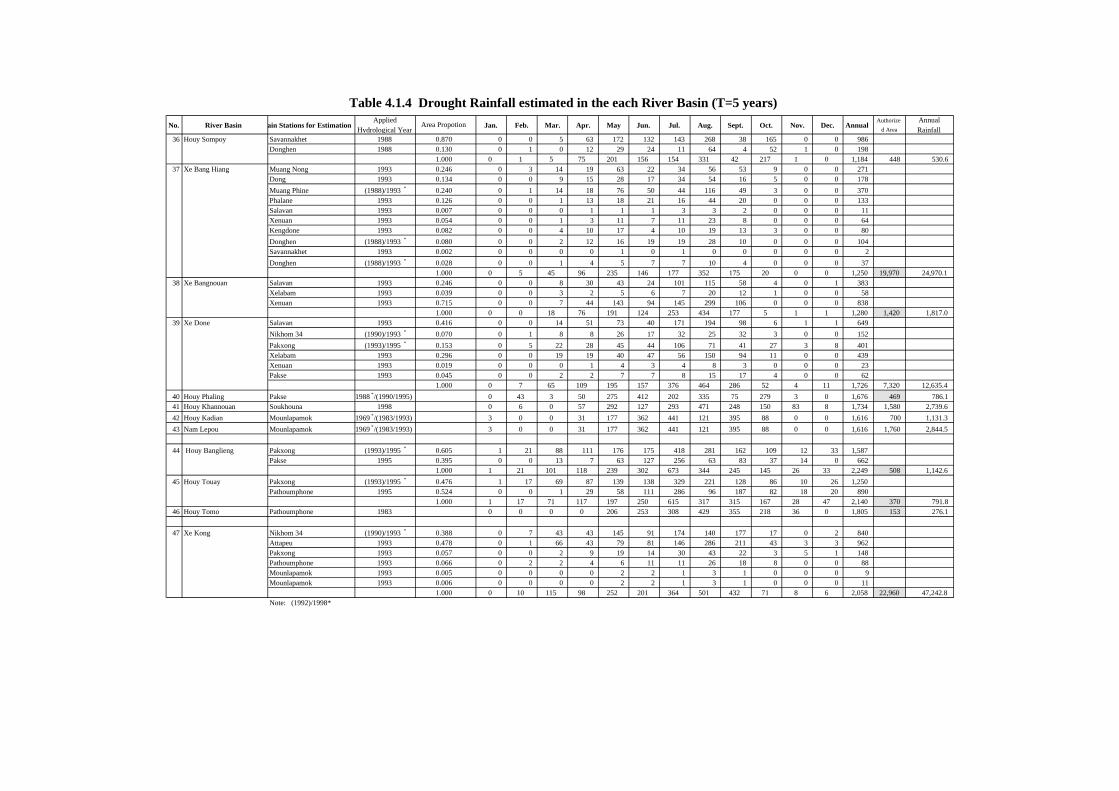
No. River Basin ain Stations for EstimationApplied
Hydrological YearArea Propotion Jan. Feb. Mar. Apr. May Jun. Jul. Aug. Sept. Oct. Nov. Dec. Annual
Authorized Area
AnnualRainfall
36 Houy Sompoy Savannakhet 1988 0.870 0 0 5 63 172 132 143 268 38 165 0 0 986Donghen 1988 0.130 0 1 0 12 29 24 11 64 4 52 1 0 198
1.000 0 1 5 75 201 156 154 331 42 217 1 0 1,184 448 530.637 Xe Bang Hiang Muang Nong 1993 0.246 0 3 14 19 63 22 34 56 53 9 0 0 271
Dong 1993 0.134 0 0 9 15 28 17 34 54 16 5 0 0 178Muang Phine (1988)/1993 * 0.240 0 1 14 18 76 50 44 116 49 3 0 0 370Phalane 1993 0.126 0 0 1 13 18 21 16 44 20 0 0 0 133Salavan 1993 0.007 0 0 0 1 1 1 3 3 2 0 0 0 11Xenuan 1993 0.054 0 0 1 3 11 7 11 23 8 0 0 0 64Kengdone 1993 0.082 0 0 4 10 17 4 10 19 13 3 0 0 80Donghen (1988)/1993 * 0.080 0 0 2 12 16 19 19 28 10 0 0 0 104Savannakhet 1993 0.002 0 0 0 0 1 0 1 0 0 0 0 0 2Donghen (1988)/1993 * 0.028 0 0 1 4 5 7 7 10 4 0 0 0 37
1.000 0 5 45 96 235 146 177 352 175 20 0 0 1,250 19,970 24,970.138 Xe Bangnouan Salavan 1993 0.246 0 0 8 30 43 24 101 115 58 4 0 1 383
Xelabam 1993 0.039 0 0 3 2 5 6 7 20 12 1 0 0 58Xenuan 1993 0.715 0 0 7 44 143 94 145 299 106 0 0 0 838
1.000 0 0 18 76 191 124 253 434 177 5 1 1 1,280 1,420 1,817.039 Xe Done Salavan 1993 0.416 0 0 14 51 73 40 171 194 98 6 1 1 649
Nikhom 34 (1990)/1993 * 0.070 0 1 8 8 26 17 32 25 32 3 0 0 152Pakxong (1993)/1995 * 0.153 0 5 22 28 45 44 106 71 41 27 3 8 401Xelabam 1993 0.296 0 0 19 19 40 47 56 150 94 11 0 0 439Xenuan 1993 0.019 0 0 0 1 4 3 4 8 3 0 0 0 23Pakse 1993 0.045 0 0 2 2 7 7 8 15 17 4 0 0 62
1.000 0 7 65 109 195 157 376 464 286 52 4 11 1,726 7,320 12,635.440 Houy Phaling Pakse 1988 */(1990/1995) 0 43 3 50 275 412 202 335 75 279 3 0 1,676 469 786.141 Houy Khannouan Soukhouna 1998 0 6 0 57 292 127 293 471 248 150 83 8 1,734 1,580 2,739.642 Houy Kadian Mounlapamok 1969 */(1983/1993) 3 0 0 31 177 362 441 121 395 88 0 0 1,616 700 1,131.343 Nam Lepou Mounlapamok 1969 */(1983/1993) 3 0 0 31 177 362 441 121 395 88 0 0 1,616 1,760 2,844.5
44 Houy Banglieng Pakxong (1993)/1995 * 0.605 1 21 88 111 176 175 418 281 162 109 12 33 1,587Pakse 1995 0.395 0 0 13 7 63 127 256 63 83 37 14 0 662
1.000 1 21 101 118 239 302 673 344 245 145 26 33 2,249 508 1,142.645 Houy Touay Pakxong (1993)/1995 * 0.476 1 17 69 87 139 138 329 221 128 86 10 26 1,250
Pathoumphone 1995 0.524 0 0 1 29 58 111 286 96 187 82 18 20 8901.000 1 17 71 117 197 250 615 317 315 167 28 47 2,140 370 791.8
46 Houy Tomo Pathoumphone 1983 0 0 0 0 206 253 308 429 355 218 36 0 1,805 153 276.1
47 Xe Kong Nikhom 34 (1990)/1993 * 0.388 0 7 43 43 145 91 174 140 177 17 0 2 840Attapeu 1993 0.478 0 1 66 43 79 81 146 286 211 43 3 3 962Pakxong 1993 0.057 0 0 2 9 19 14 30 43 22 3 5 1 148Pathoumphone 1993 0.066 0 2 2 4 6 11 11 26 18 8 0 0 88Mounlapamok 1993 0.005 0 0 0 0 2 2 1 3 1 0 0 0 9Mounlapamok 1993 0.006 0 0 0 0 2 2 1 3 1 0 0 0 11
1.000 0 10 115 98 252 201 364 501 432 71 8 6 2,058 22,960 47,242.8Note: (1992)/1998*
Table 4.1.4 Drought Rainfall estimated in the each River Basin (T=5 years)

No. River Basin Basin Area AnnualRainfall
AverageAnnualRunoff
Jan. Feb. Mar. Apr. May Jun. Jul. Aug. Sept. Oct. Nov. Dec. Annual (Km2) (MCM) (MCM)
1 Nam Ma 1999 50 0 6 43 374 167 260 253 177 104 72 38 1,542 1,080 1,666 0.58 9662 Nam Pha 1999 50 0 6 43 374 167 260 253 177 104 72 38 1,542 2,860 4,411 0.58 2,5583 Nam Kha 1999 50 0 6 43 374 167 260 253 177 104 72 38 1,542 1,630 2,514 0.58 1,4584 Nam Ngam 1999 50 0 6 43 374 167 260 253 177 104 72 38 1,542 1,500 2,313 0.58 1,3425 Nam Tha 1999 50 0 6 43 374 167 260 253 177 104 72 38 1,542 8,990 13,865 0.58 8,0426 Nam Beng 1999 50 0 6 43 374 167 260 253 177 104 72 38 1,542 2,120 3,270 0.58 1,8967 Nam Ou 1999 32 17 24 137 188 190 84 366 137 64 34 30 1,304 24,500 31,957 0.58 18,5358 Nam Xuang 1999 5 1 29 68 109 245 149 340 125 30 14 10 1,125 6,580 7,404 0.58 4,2959 Nam Khan 1999 6 0 55 123 271 312 199 427 200 80 47 31 1,752 7,380 12,931 0.58 7,50010 Nam Ngum, Sayabouly Pro. 1999 50 0 6 43 374 167 260 253 177 104 72 38 1,542 1,900 2,930 0.58 1,70011 Nam Houng 1999 0 13 54 124 48 208 212 256 252 68 58 0 1,293 2,940 3,801 0.58 2,20512 Nam Pouly 1999 0 13 54 124 48 208 212 256 252 68 58 0 1,293 1,700 2,198 0.58 1,27513 Nam Phoun 1999 0 13 54 124 48 208 212 256 252 68 58 0 1,293 1,980 2,560 0.58 1,48514 Nam Heung 1999 0 0 75 70 364 244 186 345 258 101 1 0 1,643 1,940 3,187 0.58 1,84915 Nam Mi 1999 0 0 75 70 364 244 186 345 258 101 1 0 1,643 1,040 1,709 0.58 99116 Nam Sang 1999 0 0 75 70 364 244 186 345 258 101 1 0 1,643 1,300 2,136 0.58 1,23917 Nam Thon 1999 0 0 75 70 364 244 186 345 258 101 1 0 1,643 553 909 0.58 52718 Nam Et 1999 4 2 30 90 152 251 169 388 117 27 17 17 1,263 3,410 4,306 0.58 2,49719 Nam Xan 1999 4 3 50 161 367 283 167 496 152 72 54 59 1,867 4,328 8,082 0.58 4,68820 Nam Luong 1999 4 3 50 161 367 283 167 496 152 72 54 59 1,867 620 1,158 0.58 67221 Nam Neun 1999 4 3 51 157 354 277 165 488 149 70 52 56 1,825 3,732 6,811 0.58 3,95122 Nam Mat 1999 5 0 54 119 220 213 148 412 127 47 25 19 1,390 2,052 2,852 0.58 1,65423 Nam Mo 1999 2 2 93 200 541 502 343 530 226 67 45 35 2,586 1,728 4,469 0.58 2,59224 Nam Lik 1994 0 8 151 65 254 348 486 464 231 112 1 5 2,125 4,980 10,583 0.80 8,46625 Upper Nam Ngum 1999 5 0 64 162 369 350 300 433 219 64 28 17 2,010 4,640 9,327 0.58 5,41026 Lower Nam Ngum 1998 0 16 33 120 259 382 439 425 239 73 11 0 1,997 6,920 13,817 0.65 * 8,98127 Nam Mang 1996 2 45 96 136 215 427 258 272 381 80 104 0 2,017 1,860 3,751 0.58 2,17528 Nam Ngiep 1999 3 0 92 226 535 491 458 462 257 55 27 9 2,614 4,490 11,737 0.61 7,15929 Nam Xane 1994 0 83 110 69 276 712 624 583 263 60 5 13 2,797 2,220 6,209 0.80 4,96730 Nam Kading 1992 10 31 10 36 171 346 382 360 480 244 111 41 2,223 14,960 33,255 0.94 31,26031 Nam Thon 1992 0 0 1 51 97 153 416 793 792 486 303 59 3,153 797 2,513 0.94 2,36232 Nam Hinboun 1995 0 15 36 57 297 482 491 580 268 172 77 1 2,476 3,380 8,369 0.62 5,18933 Nam Don 1994 0 62 89 56 167 685 494 433 233 39 1 0 2,259 674 1,522 0.62 944
Rainfall in Catchment Area (mm)Applied HydrologicalYear
AverageAnnual
Runoff Ratio
Table 4.1.5 Annual Runoff in Ordinary Hydrological Year (1/2)
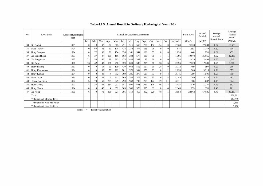
No. River Basin Basin Area AnnualRainfall
AverageAnnualRunoff
Jan. Feb. Mar. Apr. May Jun. Jul. Aug. Sept. Oct. Nov. Dec. Annual (Km2) (MCM) (MCM)
34 Xe Banfai 1995 0 13 32 87 305 471 516 568 206 152 14 0 2,363 9,330 22,049 0.62 13,67035 Nam Thahao 1994 0 69 31 69 178 424 238 474 163 28 0 0 1,675 692 1,159 0.62 71836 Houy Sompoy 1994 0 72 39 56 154 356 161 544 190 55 0 0 1,626 448 728 0.62 45237 Xe Bang Hiang 1997 6 37 47 180 186 163 384 577 136 79 1 1 1,796 19,970 35,865 0.62 22,23638 Xe Bangnouan 1997 22 58 69 88 363 175 489 347 85 60 0 0 1,755 1,420 2,493 0.62 1,54539 Xe Done 1997 13 42 42 181 250 359 609 586 225 67 16 6 2,396 7,320 17,536 0.21 3,68340 Houy Phaling 1987 0 0 14 59 139 430 663 552 167 60 28 0 2,112 469 990 0.21 20841 Houy Khannouan 1994 0 0 62 58 202 281 376 304 658 93 0 2 2,035 1,580 3,216 0.21 67542 Houy Kadian 1994 0 0 43 4 352 369 386 378 525 83 0 4 2,145 700 1,501 0.21 31543 Nam Lepou 1994 0 0 43 4 352 369 386 378 525 83 0 4 2,145 1,760 3,774 0.21 79344 Houy Banglieng 1997 5 79 69 229 229 490 933 797 299 122 39 21 3,311 508 1,682 0.49 82445 Houy Touay 1997 8 46 64 234 211 381 895 681 354 108 46 17 3,045 370 1,127 0.49 55246 Houy Tomo 1994 0 0 43 4 352 369 386 378 525 83 0 4 2,145 153 328 0.49 16147 Xe Kong 1999 6 0 73 366 327 386 710 455 362 220 48 1 2,954 22,960 67,835 0.49 33,239
Total 229,901Tributaries of Mekong River 214,519Tributaries of Nam Ma River 7,185Tributaries of Nam Ka River 8,196
Note : * Tentative assumption
Table 4.1.5 Annual Runoff in Ordinary Hydrological Year (2/2)
Applied HydrologicalYear
Rainfall in Catchment Area (mm) AverageAnnual
Runoff Ratio

Annual Annual
Name of River Station C. Area(Km2)
ObservePeriod Jan. Feb. Mar. Apr. May Jun. Jul. Aug. Sept. Oct. Nov. Dec. Mean
(m3/sec)Runoff(MMC)
Nam Sane Muang Kao 2,029 1991-99 21.7 18.1 15.0 17.9 47.2 190.4 432.4 514.9 317.1 105.8 55.0 34.1 148.5 4,685
Nam Ngum Pak Kanhoung 13,560 1991-99 97.5 87.5 78.6 82.9 135.2 261.2 468.1 534.1 599.8 253.7 155.9 122.5 252.3 7,961
Xe Kong Attapeu 10,500 1990-99 97.5 87.5 78.6 82.9 135.2 261.2 468.1 534.1 599.8 253.7 155.9 122.5 252.3 7,961
Nam Lik Hin Heup 5,115 1991-2000 97.5 87.5 78.6 82.9 135.2 261.2 468.1 534.1 599.8 253.7 155.9 122.5 252.3 7,961
Xe Ban Fai Mahaxay 4,520 1994-99 20.8 15.9 11.2 12.8 37.2 194.1 598.5 827.9 697.7 241.2 125.7 41.9 268.9 8,484
Nam Lik Muang Kasy 374 1988-99 5.6 4.5 4.1 4.0 5.9 11.0 25.4 27.8 25.1 17.5 8.3 6.0 11.3 357
Nam Nhiep Muang Mai 4,305 1991-99 54.7 43.1 39.2 40.6 83.9 232.9 430.0 598.9 543.7 187.0 107.9 71.6 203.7 6,428
Nam Ngum Naluang 4,852 1990-99 36.1 29.5 26.1 30.5 61.2 161.2 355.4 412.1 318.1 122.8 85.5 51.6 143.3 4,521
Xe Done Sou Van Na Khil 5,760 1993-99 20.3 16.6 11.9 19.7 56.4 112.1 443.0 615.5 495.2 114.5 65.1 32.9 168.1 5,301
Nam Theun Singo 3,370 1990-99 38.7 31.3 25.2 24.5 42.4 208.1 502.8 611.7 524.0 267.2 125.7 68.8 207.0 6,533
Nam Song Vang Vieng 864 1987-99 11.3 8.7 7.6 7.9 18.9 57.8 116.8 124.5 100.2 46.4 35.8 24.9 50.8 1,603
Monthly Mean Discharge (m3/sec)
Table 4.1.6 Monthly Mean Discharge of Major Rivers in Lao PDR
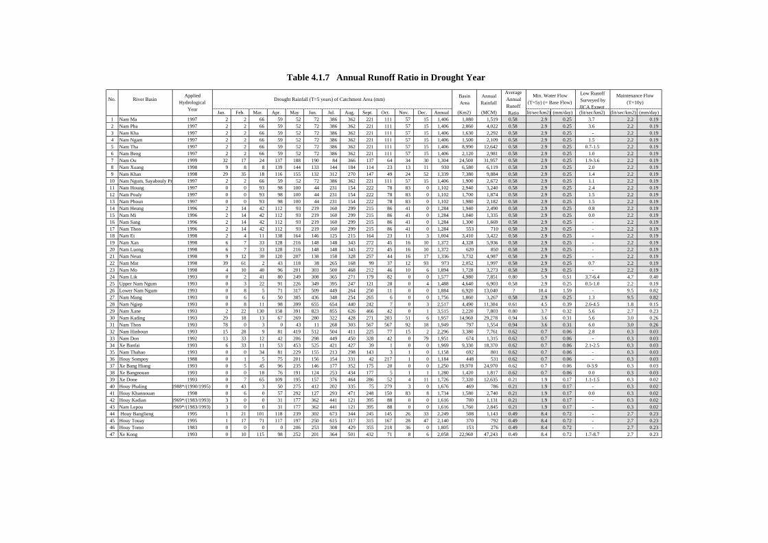
No. River Basin BasinArea
AnnualRainfall
Low RunoffSurveyed byJICA Expert
Jan. Feb. Mar. Apr. May Jun. Jul. Aug. Sept. Oct. Nov. Dec. Annual (Km2) (MCM) (lit/sec/km2) (mm/day) (lit/sec/km2) (lit/sec/km2) (mm/day)1 Nam Ma 1997 2 2 66 59 52 72 386 362 221 111 57 15 1,406 1,080 1,519 0.58 2.9 0.25 3.7 2.2 0.192 Nam Pha 1997 2 2 66 59 52 72 386 362 221 111 57 15 1,406 2,860 4,022 0.58 2.9 0.25 3.6 2.2 0.193 Nam Kha 1997 2 2 66 59 52 72 386 362 221 111 57 15 1,406 1,630 2,292 0.58 2.9 0.25 - 2.2 0.194 Nam Ngam 1997 2 2 66 59 52 72 386 362 221 111 57 15 1,406 1,500 2,109 0.58 2.9 0.25 1.5 2.2 0.195 Nam Tha 1997 2 2 66 59 52 72 386 362 221 111 57 15 1,406 8,990 12,642 0.58 2.9 0.25 0.7-1.5 2.2 0.196 Nam Beng 1997 2 2 66 59 52 72 386 362 221 111 57 15 1,406 2,120 2,981 0.58 2.9 0.25 1.0 2.2 0.197 Nam Ou 1999 32 17 24 137 188 190 84 366 137 64 34 30 1,304 24,500 31,957 0.58 2.9 0.25 1.9-3.6 2.2 0.198 Nam Xuang 1998 9 8 8 139 144 133 144 184 114 23 13 11 930 6,580 6,119 0.58 2.9 0.25 2.0 2.2 0.199 Nam Khan 1998 29 35 18 116 155 132 312 270 147 49 24 52 1,339 7,380 9,884 0.58 2.9 0.25 1.4 2.2 0.19
10 Nam Ngum, Sayabouly Pr 1997 2 2 66 59 52 72 386 362 221 111 57 15 1,406 1,900 2,672 0.58 2.9 0.25 1.1 2.2 0.1911 Nam Houng 1997 0 0 93 98 100 44 231 154 222 78 83 0 1,102 2,940 3,240 0.58 2.9 0.25 2.4 2.2 0.1912 Nam Pouly 1997 0 0 93 98 100 44 231 154 222 78 83 0 1,102 1,700 1,874 0.58 2.9 0.25 1.5 2.2 0.1913 Nam Phoun 1997 0 0 93 98 100 44 231 154 222 78 83 0 1,102 1,980 2,182 0.58 2.9 0.25 1.5 2.2 0.1914 Nam Heung 1996 2 14 42 112 93 219 160 299 215 86 41 0 1,284 1,940 2,490 0.58 2.9 0.25 0.8 2.2 0.1915 Nam Mi 1996 2 14 42 112 93 219 160 299 215 86 41 0 1,284 1,040 1,335 0.58 2.9 0.25 0.0 2.2 0.1916 Nam Sang 1996 2 14 42 112 93 219 160 299 215 86 41 0 1,284 1,300 1,669 0.58 2.9 0.25 - 2.2 0.1917 Nam Thon 1996 2 14 42 112 93 219 160 299 215 86 41 0 1,284 553 710 0.58 2.9 0.25 - 2.2 0.1918 Nam Et 1998 2 4 11 138 164 146 125 215 164 23 11 3 1,004 3,410 3,422 0.58 2.9 0.25 - 2.2 0.1919 Nam Xan 1998 6 7 33 128 216 148 148 343 272 45 16 10 1,372 4,328 5,936 0.58 2.9 0.25 - 2.2 0.1920 Nam Luong 1998 6 7 33 128 216 148 148 343 272 45 16 10 1,372 620 850 0.58 2.9 0.25 - 2.2 0.1921 Nam Neun 1998 9 12 30 120 207 138 158 328 257 44 16 17 1,336 3,732 4,987 0.58 2.9 0.25 - 2.2 0.1922 Nam Mat 1998 39 61 2 43 118 38 265 168 99 37 12 93 973 2,052 1,997 0.58 2.9 0.25 0.7 2.2 0.1923 Nam Mo 1998 4 10 40 96 201 303 500 468 212 46 10 6 1,894 1,728 3,273 0.58 2.9 0.25 - 2.2 0.1924 Nam Lik 1993 0 2 41 80 249 308 365 271 179 82 0 0 1,577 4,980 7,851 0.80 5.9 0.51 3.7-6.4 4.7 0.4025 Upper Nam Ngum 1993 0 3 22 91 226 349 395 247 121 28 0 4 1,488 4,640 6,903 0.58 2.9 0.25 0.5-1.0 2.2 0.1926 Lower Nam Ngum 1993 0 8 5 71 317 509 449 264 250 11 0 0 1,884 6,920 13,040 ? 18.4 1.59 - 9.5 0.8227 Nam Mang 1993 0 6 6 50 385 436 348 254 265 6 0 0 1,756 1,860 3,267 0.58 2.9 0.25 1.3 9.5 0.8228 Nam Ngiep 1993 0 8 11 98 399 655 654 440 242 7 0 3 2,517 4,490 11,304 0.61 4.5 0.39 2.6-4.5 1.8 0.1529 Nam Xane 1993 2 22 130 158 391 823 855 626 466 42 0 1 3,515 2,220 7,803 0.80 3.7 0.32 5.6 2.7 0.2330 Nam Kading 1993 29 18 13 67 269 280 322 428 271 203 51 6 1,957 14,960 29,278 0.94 3.6 0.31 5.6 3.0 0.2631 Nam Thon 1993 78 0 3 0 43 11 268 303 567 567 92 18 1,949 797 1,554 0.94 3.6 0.31 6.0 3.0 0.2632 Nam Hinboun 1993 15 28 9 81 419 512 504 411 225 77 15 2 2,296 3,380 7,761 0.62 0.7 0.06 2.8 0.3 0.0333 Nam Don 1992 13 33 12 42 206 298 449 450 328 42 0 79 1,951 674 1,315 0.62 0.7 0.06 - 0.3 0.0334 Xe Banfai 1993 6 33 11 53 453 525 421 427 39 1 0 0 1,969 9,330 18,370 0.62 0.7 0.06 2.1-2.5 0.3 0.0335 Nam Thahao 1993 0 0 34 81 229 155 213 298 143 3 1 0 1,158 692 801 0.62 0.7 0.06 - 0.3 0.0336 Houy Sompoy 1988 0 1 5 75 201 156 154 331 42 217 1 0 1,184 448 531 0.62 0.7 0.06 - 0.3 0.0337 Xe Bang Hiang 1993 0 5 45 96 235 146 177 352 175 20 0 0 1,250 19,970 24,970 0.62 0.7 0.06 0-3.9 0.3 0.0338 Xe Bangnouan 1993 0 0 18 76 191 124 253 434 177 5 1 1 1,280 1,420 1,817 0.62 0.7 0.06 0.0 0.3 0.0339 Xe Done 1993 0 7 65 109 195 157 376 464 286 52 4 11 1,726 7,320 12,635 0.21 1.9 0.17 1.1-1.5 0.3 0.0240 Houy Phaling 1988*/(1990/1995) 0 43 3 50 275 412 202 335 75 279 3 0 1,676 469 786 0.21 1.9 0.17 - 0.3 0.0241 Houy Khannouan 1998 0 6 0 57 292 127 293 471 248 150 83 8 1,734 1,580 2,740 0.21 1.9 0.17 0.0 0.3 0.0242 Houy Kadian 1969*/(1983/1993) 3 0 0 31 177 362 441 121 395 88 0 0 1,616 700 1,131 0.21 1.9 0.17 - 0.3 0.0243 Nam Lepou 1969*/(1983/1993) 3 0 0 31 177 362 441 121 395 88 0 0 1,616 1,760 2,845 0.21 1.9 0.17 - 0.3 0.0244 Houy Banglieng 1995 1 21 101 118 239 302 673 344 245 145 26 33 2,249 508 1,143 0.49 8.4 0.72 - 2.7 0.2345 Houy Touay 1995 1 17 71 117 197 250 615 317 315 167 28 47 2,140 370 792 0.49 8.4 0.72 - 2.7 0.2346 Houy Tomo 1983 0 0 0 0 206 253 308 429 355 218 36 0 1,805 153 276 0.49 8.4 0.72 - 2.7 0.2347 Xe Kong 1993 0 10 115 98 252 201 364 501 432 71 8 6 2,058 22,960 47,243 0.49 8.4 0.72 1.7-8.7 2.7 0.23
Table 4.1.7 Annual Runoff Ratio in Drought Year
Maintenance Flow(T=10y)Drought Rainfall (T=5 years) of Catchment Area (mm)
AppliedHydrological
Year
AverageAnnualRunoffRatio
Min. Water Flow(T=5y) (= Base Flow)

Figure

Coordination
Coordination
Director General Meteo-hydrology Division Technical Advisor
Meteo-hydrology Station Deputy Director General Deputy Director General Hydrology StationIn charged of Administration,
Planning and ManagementIn charged of Technical
Management
Administration andPersonnel Division
Statistic Data Center
Technical Division Meteorological Networkand Agro-meteorologyWeather Forecast andAeronautic DivisionHydrology Division
Department of Meteorology and Hydrology (DMH)
Ministry of Agriculture and Forestry (MAF)
Department of Agriculture and Forestry (DMHP)
Provincial Government Office
Master Plan Study on
Integrated Agricultural D
evelopment in
Lao People's D
emocratic R
epublicO
rganization Chart of D
epartment of M
eteorologyand H
ydorology, MA
F and Provincial DM
H
Figure 1.1.1
Japan International Cooperation A
gency
AP4F-1

1700 1700
Phonsaly
Luang
OudomxayOudomxay
Master Plan Study on (Integrated Agricultural Development in (Lao
People's Democratic Republic
Japan International Cooperation Agency
Figure 2.1.1
Average Annual Rainfall (mm)
AP4F-2
108.0106.0104.0102.0100.013.8
19.8
17.8
21.8
15.8
Latit
ude
Longitude

KhanthaboouriKhanthaboouri
verSaravan
XiangkhouangXiangkhouangXaignabouriXaignabouriXaignabouri
PhongsaliPhongsali
Louang (Namth
Xai
HouayxayHouayxay
LouangphrabangLouangphrabangLouangphrabangLouangphrabangLouangphrabang
Xam NuaXam Nua
XaisombounXaisombounXaisombounXaisomboun
ViaogknamViaogknam
ThakhekThakhek
LamamLamamLamam
Samak khixaiSamak khixai
Pakse
Mekon g
River
SAVANNAKHETSAVANNAKHETSAVANNAKHET
SARAVANSARAVAN
XAIGNABOURIXAIGNABOURIXAIGNABOURI
PHONGSALIPHONGSALIPHONGSALI
LOUANG (NAMTHA
OUDOMXAIOUDOMXAIOUDOMXAI
BOKEO LOUANGPHRABANGLOUANGPHRABANGLOUANGPHRABANGLOUANGPHRABANG
HOUAPHANHOUAPHAN
XAISOMBOUNXAISOMBOUNXAISOMBOUNXAISOMBOUN
VIENTIANEVIENTIANEVIENTIANE
KHAMMOUANKHAMMOUANKHAMMOUAN
XEKONGXEKONGXEKONGXEKONG
ATTAPUATTAPUCHAMPASAKCHAMPASAKCHAMPASAK
VIENTIANE MUN.VIENTIANE MUN.VIENTIANE MUN.VIENTIANE MUN.VIENTIANE MUN.
00 100100 200200 300km300km
SCALE
Legend
Slope Gauge Station
V I E T N A M
T H A I L A N D
CAMBODIA
①①BOKEOBOKEO
②
③③③
④④
⑥⑥
⑦⑦⑧
⑨
⑩⑩
121212
11
9
10
8
7
6
15HOUAPHANHOUAPHAN
55
444333
13
21
Master Plan Study on (Integrated Agricultural Development in (Lao
People's Democratic Republic
Japan International Cooperation Agency
Figure 3.2.1 Location of Hydrology Station Constructed (Under JICA Program)
AP4F-3

VIENTIANE
KhanthaboouriKhanthaboouri
verSaravan
XiangkhouangXiangkhouangXaignabouriXaignabouriXaignabouri
PhongsaliPhongsali
Louang (Namth
Xai
HouayxayHouayxay
LouangphrabangLouangphrabangLouangphrabangLouangphrabangLouangphrabangLouangphrabang
Xam NuaXam Nua
XaisombounXaisombounXaisombounXaisomboun
Thakhek
LamamLamamLamam
Samak khixaiSamak khixai
Mekong
Ri ver
SAVANNAKHETSAVANNAKHET
SARAVANSARAVAN
XIANGKHOUANGXIANGKHOUANGXIANGKHOUANG
XAIGNABOURIXAIGNABOURIXAIGNABOURI
PHONGSALIPHONGSALIPHONGSALI
LOUANG (NAMTHA
OUDOMXAIOUDOMXAI
BOKEO LOUANGPHRABANGLOUANGPHRABANGLOUANGPHRABANGLOUANGPHRABANG
HOUAPHANHOUAPHAN
XAISOMBOUNXAISOMBOUNXAISOMBOUNXAISOMBOUN
VIENTIANE BORIKHAMXAIBORIKHAMXAI
KHAMMOUANKHAMMOUANKHAMMOUAN
XEKONGXEKONGXEKONGXEKONG
ATTAPU
CHAMPASAKCHAMPASAK
VIENTIANE MUN.VIENTIANE MUN.VIENTIANE MUN.VIENTIANE MUN.VIENTIANE MUN.
00 100100 200200 300km300km
SCALE
V I E T N A M
T H A I L A N D
CAMBODIA
BORIKHAMXAI
Master Plan Study on (Integrated Agricultural Development in (Lao
People's Democratic Republic
Japan International Cooperation Agency
Figure 3.7.1
Location of Transceiver Site
AP4F-4
1414
1212
1010
66
11
77
55
33
99
88
1313
1515
22
44
1111

VIENTIANE
KhanthaboouriKhanthaboouri
verSaravan
XiangkhouangXiangkhouangXaignabouriXaignabouriXaignabouri
PhongsaliPhongsali
Louang (Namth
Xai
HouayxayHouayxay
LouangphrabangLouangphrabangLouangphrabangLouangphrabangLouangphrabang
Xam NuaXam Nua
XaisombounXaisombounXaisombounXaisomboun
Thakhek
LamamLamamLamam
Mekong
Ri ver
SAVANNAKHETSAVANNAKHET
SARAVANSARAVAN
XIANGKHOUANGXIANGKHOUANGXIANGKHOUANGXIANGKHOUANG
XAIGNABOURIXAIGNABOURIXAIGNABOURI
PHONGSALIPHONGSALIPHONGSALI
LOUANG (NAMTHA
OUDOMXAIOUDOMXAIOUDOMXAI
BOKEO LOUANGPHRABANGLOUANGPHRABANGLOUANGPHRABANGLOUANGPHRABANG
HOUAPHANHOUAPHAN
XAISOMBOUNXAISOMBOUNXAISOMBOUNXAISOMBOUN
VIENTIANEBORIKHAMXAIBORIKHAMXAIBORIKHAMXAIBORIKHAMXAIBORIKHAMXAI
KHAMMOUANKHAMMOUANKHAMMOUAN
XEKONGXEKONGXEKONGXEKONG
ATTAPU
CHAMPASAKCHAMPASAK
VIENTIANE MUN.VIENTIANE MUN.VIENTIANE MUN.VIENTIANE MUN.VIENTIANE MUN.
00 100100 200200 300km300km
SCALE
V I E T N A M
T H A I L A N D
CAMBODIA
BORIKHAMXAI
Figure 3.7.2
Installation of Computer Unit
Master Plan Study on (Integrated Agricultural Development in (Lao
People's Democratic Republic
Japan International Cooperation Agency
AP4F-5
88
77
66
1010
1111
44
55
11
22
33
99

LEGEND Mekong River River
Nam Mi
Nam PhounNam PouyNam Houng
Nam NgumNam Beng
Nam Tha
Nam NgamNam NgamNam Ngam
Nam Pha
Nam Ma
Nam HeungNam Sang
N. MangN. Ngiep
Sebanghieng
Sebangnuan
Sedone
H. Khamouan
Nam Lepou Sekong
Sebangrai
N. Hineboune
N. Cading
N. Sane
Nam Ngum
Nam KhanNam Sang
Nam Ou
Master Plan Study on (Integrated Agricultural Development in (Lao
People's Democratic Republic
Japan International Cooperation Agency
Figure 4.1.1 Location Map of the River ((The Mekong River Basin)
AP4F-6
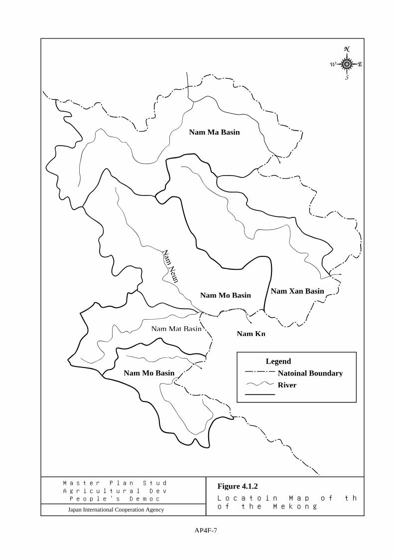
Legend Natoinal Boundary River
Nam Ma Basin
Nam Xan Basin
Nam Kn
Nam Mo Basin
Nam Mo Basin
Nam Mat Basin
Master Plan Study on (Integrated Agricultural Development in (Lao
People's Democratic Republic
Japan International Cooperation Agency
Figure 4.1.2 Locatoin Map of the River ((Outside of the Mekong River Basin)
AP4F-7