appendix a nws establishment site appraisal framework
TRANSCRIPT

1
APPENDIX A
NWS Establishment Site Appraisal Framework (14Feb13)
As set out in Forest Service Circular 04/2013, this document replaces
Appendix A of the scheme document entitled Native Woodland Scheme –
Establishment (August 2011).
Using the NWS Est. Site Appraisal Framework
The following Site Appraisal Framework is a core part of the Native Woodland Establishment Scheme (NWS
Est.). Using it, the NWS Forester appraises the site from the perspective of soil, location and main habitats /
vegetation, and matches it to one of five scenarios. From that decision flows the most appropriate native
woodland type to promote onsite, a prescribed planting mixture for that woodland type, and the relevant
Grant & Premium Category (GPC) to apply under, using the NWS Est. Form 1.
The following outlines the use of the Site Appraisal Framework in the development of a NWS Est. application.
1. Referring to the framework, the NWS Forester appraises the site in terms of: landscape position; soil type
and key soil properties (*); and main habitats and vegetation on the site itself and within nearby open
fields, hedgerows and semi-natural woodlands (where present).
2. Using this information, s/he then matches the site to one of four scenarios. These scenarios, labelled by
basic soil type, are: Scenario 1 (Podzols); Scenario 2 (Brown Podzolics); Scenario 3 (Brown Earths); and
Scenario 4 (Gleys). (An additional scenario, Scenario 5, applies to unenclosed / unimproved land – see
over for details.)
3. The framework identifies the major native woodland type associated with each of the Scenarios 1-4.
(This is informed by the results of the National Native Woodland Survey, subsequently tailored for the
NWS (**).) This woodland type then becomes the ‘target’ woodland to promote onsite. The
characteristic trees, shrubs and ground flora of each major native woodland type are presented in the
framework, together with an image depicting the woodland involved.
4. The framework then sets out the precribed species mixture, composition and layout designed to initiate
the development of the relevant native woodland type. This represents a basic woodland ‘starter kit’ –
other native species will appear naturally over time. This species mixture, composition and layout must
be followed at establishment in order for the project to be eligible under the corresponding Grant &
Premium Category (GPC) – see below.
5. Based on Circular 10/2010, the specific GPC for each scenario is stated, linking in with the specific grant
and premium level that will apply. Note: Different scenarios and associated native woodland types may
apply to different areas of the same site. This will generate separate plots, each with its own prescribed
planting mixture and corresponding GPC.
6. The NWS Forester inputs the relevant plot details and corresponding GPC(s) into the NWS Est. Form 1,
and preparation of the application proceeds, incorporating other NWS Est. requirements, general
afforestation scheme specifications (e.g. fencing), and standard mapping conventions.
(* see Appendix B of the scheme document Native Woodland Scheme – Establishment (August 2011) for
guidance on soil surveying and classification.)
(** See Cross, J.R., Perrin, P. and Little, D.J. 2010. The Classification of Native Woodlands in Ireland and its
Application to Native Woodland Management. Native Woodland Information Note No. 6. Woodlands of
Ireland, Dublin.)
Photos by John Cross, Declan Little and the Forest Service.
2
If… Location: Upland valley sides & hillsides
on free-draining slopes.
Soil: Podzols (acid, infertile soils),
average pH c.4.5.
Main habitats & vegetation:
Greenfield containing bracken, bilberry,
heathers & gorse, with Molinia grass on
flushed sites.
Semi-natural woodland dominated by /
hedgerows containing: sessile oak,
downy birch, rowan & holly, with bilberry,
ling heather & woodrush.
Scenario 1: Podzols
Most appropriate Major Native
Woodland Type: QL Sessile oak–
woodrush.
Predominant trees & shrubs: Sessile oak,
downy birch, rowan & holly.
Predominant ground flora: Bilberry, ling
heather, woodrush, hard fen, broad
buckler-fern & honeysuckle.
Planting mixture: Sessile oak (60%).
Downy birch (10%), holly (10%) & rowan
(10%) scattered intimately throughout
oak. Scots pine (10%) positioned in small
pure groups (focusing on parts of the
plot with shallower, free-draining soil, if
present).
Relevant GPC: GPC6 for enclosed /
improved sites
(GPC1 for unenclosed / unimproved sites
– see Scenario 5)
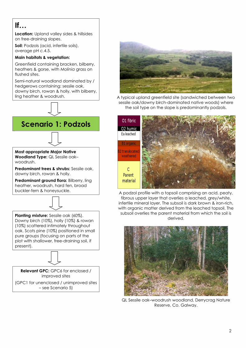
A typical upland greenfield site (sandwiched between two
sessile oak/downy birch-dominated native woods) where
the soil type on the slope is predominantly podzols.
A podzol profile with a topsoil comprising an acid, peaty,
fibrous upper layer that overlies a leached, grey/white,
infertile mineral layer. The subsoil is dark brown & iron-rich,
with organic matter derived from the leached topsoil. The
subsoil overlies the parent material from which the soil is
derived.
QL Sessile oak–woodrush woodland, Derrycrag Nature
Reserve, Co. Galway.

3
If… Location: Uplands (especially in the east),
on shale & base-rich glacial till & at the
base of free-draining valley & hillside slopes.
Soil: Brown podzolics (acid, moderately
fertile soils), average pH c.4.9.
Main habitats & vegetation:
Greenfield containing gorse, bracken,
bramble, coarse grasses (e.g. Yorkshire fog),
or improved grassland.
Semi-natural woodland dominated by /
hedgerows containing: sessile oak, downy
birch, ash, hazel, rowan & holly, with
bramble, bluebell, violet, herb-Robert &
wood avens.
Scenario 2:
Brown podzolics
Most appropriate Major Native Woodland
Type: QL3 Bramble–hazel (subtype of QL
Sessile oak–woodrush).
Predominant trees & shrubs: Sessile oak,
downy birch, ash, hazel, rowan & holly.
Predominant ground flora: Bramble, ivy,
broad buckler-fern, wood sorrel, bluebell,
violet, woodrush & wood avens. Dwarf
shrubs largely absent.
Planting mixture: Sessile oak (65%). Downy
birch (5%) & hazel (10%) scattered
intimately throughout. Wild cherry (5%),
planted in groups of 5 to 10 trees.
Minor species (15%) to comprise at least
three of the following, positioned alongside
planned woodland edges & glades: Scots
pine (on shallow, more acid, rocky areas, if
present), hawthorn, holly, rowan, crab
apple.
Relevant GPC: GPC6 for enclosed /
improved sites
(GPC1 for unenclosed / unimproved sites –
see Scenario 5)
Recently planted sessile
oak/downy birch-
dominated native
woodland at the
footslope of an upland
landscape. Brown
podzolic soils often
occur at the foot slopes
and/or where
moderately base-rich till
is a component of the
soil parent material.
Bluebell is present in the
foreground.
A brown podzolic profile with a topsoil comprising a thin,
acid, peaty, upper layer overlying a yellow-brown lower
topsoil layer, which in turn overlies a red-brown, iron-rich
subsoil. Beneath the subsoil is the parent material from
which the soil is derived.
A good example of the QL3 Bramble–hazel woodland type,
Co. Cavan.
4
If… Location: Lowlands on calcareous soils.
Soil: (Acid) Brown earths, fertile,
heavy/moist to light/dry. Average pH c. 5.9.
Main habitats & vegetation:
Greenfield typically improved or semi-
improved grassland seeded with perennial
rye-grass, often mixed with red clover.
Semi-natural woodland dominated by /
hedgerows containing: ash, pedunculate
oak, downy birch, rowan, hazel, hawthorn,
holly, spindle & blackthorn. Field layer
indicators include bramble, ivy, wood
avens, wood sorrel, wood speedwell, wild
arum, herb Robert & bluebell.
Scenario 3: Brown earths
Most appropriate Major Native Woodland
Type: FH Ash–ivy.
Predominant trees & shrubs: Ash, hazel,
pedunculate oak, downy birch, elm, rowan,
hawthorn, holly, spindle & blackthorn.
Predominant ground flora: Bramble,
honeysuckle, ivy, wood avens, wood sorrel,
wood speedwell, barren & true strawberry,
wild arum, wood sanicle, bluebell, violet,
wood brome & enchanter’s nightshade.
Planting mixture: Pedunculate oak (40%).
Downy birch (20%), hazel (20%) & hawthorn
(5%) scattered throughout. Wild cherry (5%),
planted in groups of 5 to 10 trees.
Minor species (10%) to comprise at least
three of the following, positioned alongside
planned woodland edges & glades: holly,
spindle, rowan, crab apple & (on wetter
areas of the plot) alder.
Relevant GPC: GPC5
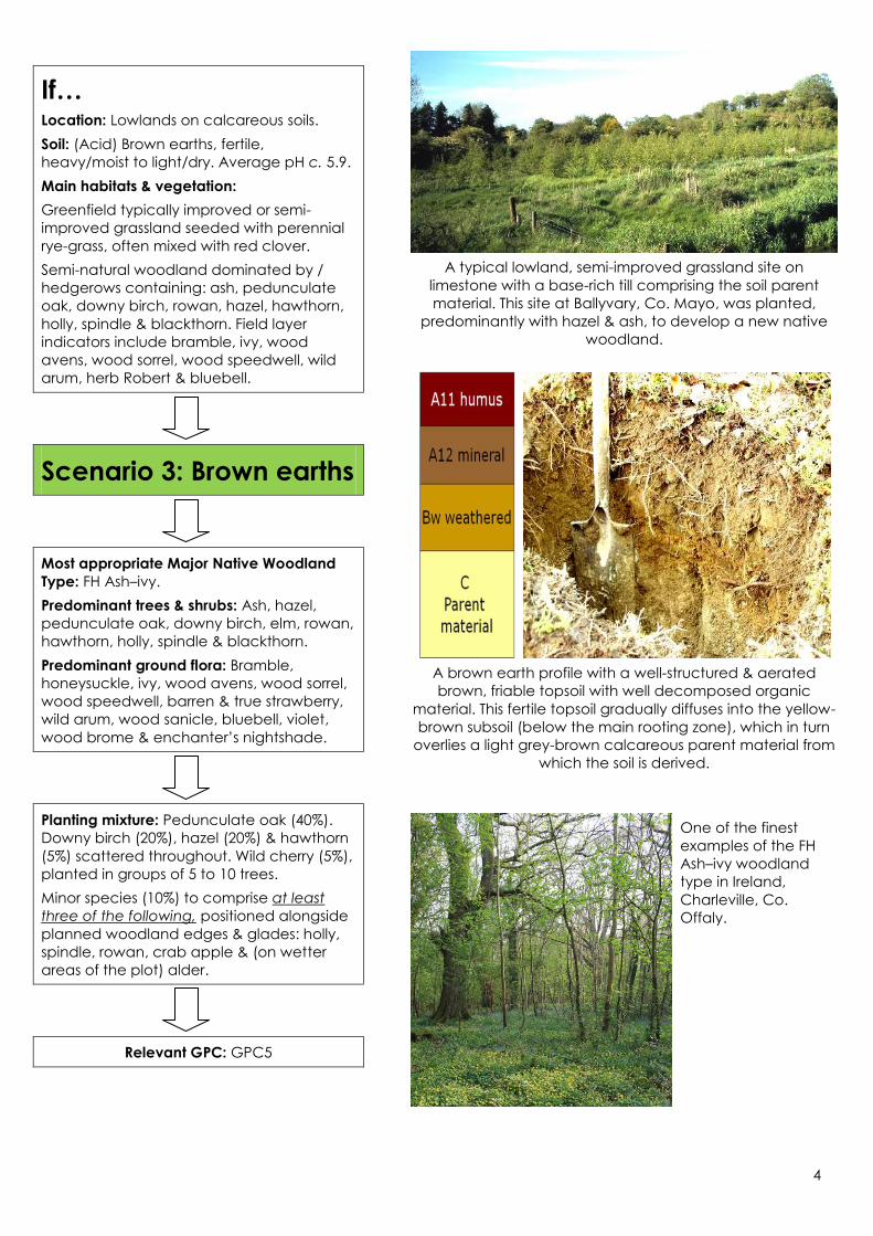
A typical lowland, semi-improved grassland site on
limestone with a base-rich till comprising the soil parent
material. This site at Ballyvary, Co. Mayo, was planted,
predominantly with hazel & ash, to develop a new native
woodland.
A brown earth profile with a well-structured & aerated
brown, friable topsoil with well decomposed organic
material. This fertile topsoil gradually diffuses into the yellow-
brown subsoil (below the main rooting zone), which in turn
overlies a light grey-brown calcareous parent material from
which the soil is derived.
One of the finest
examples of the FH
Ash–ivy woodland
type in Ireland,
Charleville, Co.
Offaly.

5
If… Location: Drumlins, river valleys, lake shores
& water-logged hollows.
Soil: Mineral & peaty gleys (very wet soils,
generally fertile). Average pH c.5.9.
Main habitats & vegetation:
Wet, rushy grassland with yellow flag.
Semi-natural woodland dominated by /
hedgerows containing: alder, ash, grey
willow, hazel, hawthorn, spindle &
blackthorn. Field layer indicators include
bramble, meadowsweet, creeping
buttercup, remote sedge.
Scenario 4: Gleys
Most appropriate Major Native Woodland
Type: AF Alder–meadowsweet.
Predominant trees & shrubs: Alder, grey
willow & ash.
Predominant ground flora: Meadowsweet,
remote sedge, creeping buttercup, yellow
flag & water mint.
Planting mixture: Pure groups (30-40 trees)
of alder (50%), grey willow (10%) & downy
birch (10%). Groups interspersed alternately.
Pedunculate oak (10%) on drier areas.
Hawthorn (5%) scattered throughout.
Minor species (15%) to comprise at least
three of the following, positioned between
the above pure groups: holly, hazel, guelder
rose.
Note: The above interspersed group
planting of major species is carried out to
improve stability & robustness, & to prevent
the development of an alder monoculture.
Relevant GPC: GPC8 for enclosed /
improved sites
(GPC1 for unenclosed / unimproved sites –
see Scenario 5)
A typical ’rushy’ field with heavy, wet gley soils. These are
sometimes semi-improved for pasture & are common in
drumlin belts, low-lying, & poorly drained locations.
A very poorly-drained ‘dauby’ gley soil profile with a clay-
rich topsoil approx. 30 cm deep, which overlies a saturated
& mottled, blue-grey & red-brown subsoil. The subsoil
overlies a very compact parent material derived from
glacial till.
A typical AF
Alder–
meadowsweet
alluvial
woodland on
gley soil.
Hazelwood, Co.
Sligo.

6
If… Unenclosed / Unimproved land, as per
Forest Circular 18/2011…
Scenario 5:
Unenclosed land
As set out in Forest Service Circular 10/2010,
the amount of unenclosed land in any
application for financial approval under
NWS Est. cannot exceed 20% of the total
area.
Typically, within the context of NWS Est.,
unenclosed land will lie upslope of enclosed
land. Soils are most often peaty podzols or
brown podzolics, or a gleyed version of
either type. (Other types of unenclosed
land may be considered under NWS Est., on
a case-by-case basis.)
Based on the assessment (i.e. location, soil
type, main habitats & vegetation) of the
unenclosed site, go to Scenario 1 (Podzols),
Scenario 2 (Brown podzolics) or Scenario 4
(Gleys) for details on native woodland type
& the planting prescription to be applied.
Note: As unenclosed land, GPC1 applies,
regardless of the woodland classification &
planting prescription identified for the site.
Note: Scenario 5 not relevant within Acid
Sensitive Areas. In these areas, sites must
wholly comprise enclosed land, as per
Circular 04/2013.
End

7