appendix a - proposed development masterplan
TRANSCRIPT

Redhill AAP Flood Risk Assessment FINAL
Appendix A - Proposed Development Masterplan

Redhill AAP Flood Risk Assessment FINAL
THIS PAGE LEFT BLANK INTENTIONALLY FOR DOUBLE-SIDED PRINTING

Redhill AAP Flood Risk Assessment FINAL
Appendix B - Flood Maps

Redhill AAP Flood Risk Assessment FINAL
THIS PAGE LEFT BLANK INTENTIONALLY FOR DOUBLE-SIDED PRINTING

Redhill AAP Flood Risk Assessment FINAL
Flood Zone Map 1 – Fluvial 375 minutes (displayed flood depth 50mm minimum)

Redhill AAP Flood Risk Assessment FINAL
Flood Zone Map 2 – Surface Water 60 minutes (displayed flood depth 50mm minimum)

Redhill AAP Flood Risk Assessment FINAL
Flood Zone Map 3 – Fluvial 375 minutes (displayed flood depth 10mm minimum)

Redhill AAP Flood Risk Assessment FINAL
Flood Zone Map 4 – Surface Water 60 minutes (displayed flood depth 10mm minimum)

Redhill AAP Flood Risk Assessment FINAL
Appendix C - Flood Hazard Maps

Redhill AAP Flood Risk Assessment FINAL
Flood Hazard describes an assessment of risk to pedestrians and cars from fast flowing and /or deep surface water. Flood Hazard has been estimated using the velocity and depth derived from the 2D model and mapped as at Appendix C - The mapping indicates by the use of the length and density arrows areas where velocities are relatively high.
Hazard is the product of depth and velocity where a depth of 0.6m at a velocity of 1m/s can move a car and a depth of 0.15m at 1 m/s can destabilise a pedestrian’s footing.
However, the velocity of the water in Redhill shown on the mapping is 0.1m/s which in terms of hazard is very low. There are very few areas where velocity is as high as 1m/s but the depth is shallow. The depths shown in the legend are in meters for example red is at least 0.5m of depth.
Depth of water is indicated in red and dark blue where water accumulates in low-lying terrain or behind a structure.
Flood Hazard Map 1 – Surface Water (Base case M100-60) Velocity 0.1m/s, depth in meters.

Redhill AAP Flood Risk Assessment FINAL
Appendix D - Options to Reduce Flood Risk
1.1 Base Case
The base-case flood risk maps developed by RBBC, and accepted by the EA for town planning, indicate that the town centre, at Marketfield Way and Colebrook in particular, include areas that are within Flood Zones 3b, 3a and 2 which would severely restrict the development of these sites. There is an area of functional flood plain in the Reading - Arch Road site but if a development were to retain the existing open-space the flood plain can be accommodated in this area.
1.2 Flood Maps and Climate Change
The maps used for the FRA (Figures 1 and 2) are ‘Base-case’ maps in that they show the current level flood risk to Redhill at the present day. They tell us what property and infrastructure is at risk should a storm event occur with a likely magnitude of one chance in a hundred in any one year. This is called the 1% Annual Exceedance Probability (AEP). A 5% AEP is likely to occur five times as often and would be of a smaller magnitude i.e. less flooding. When assessing current risk, the base-case map is used.
Scientists predict that future storms will be more severe such that a 1%AEP storm of today is likely to occur with greater frequency, i.e. the future 1%AEP storm will have a greater magnitude of rainfall runoff leading to greater flood risk. To predict future risk we model flood events allowing an increase in rainfall runoff by 20% above the current amount which is an estimate of the increase up to the year 2080. This is the allowance for Climate Change which increases the magnitude of the storm runoff and therefore the flood envelope is usually greater. In order to design for the future, maps that include for Climate Change are used. The ‘Option’ maps (Figures 3 and 4) do include the allowance for climate change and have a greater flood envelope warning that future development needs to allow more space for water.
1.3 Memorial Park
Memorial Park is included in this assessment not as one of the proposed development sites but only for amenity. A very small part of the site may possibly be used for a cafeteria. The impact of flooding would need to be established to determine a suitable location
It was evident that the park in its present state is prone to flooding. Modelling indicated that the park could be redesigned to formalise the natural flood attenuation to reduce flood risk in the town. To develop a formal flood attenuation area, various options were tested which included having the Lynwood Ditch either remain in culvert as at present or as an open channel within the park. The option was also tested in conjunction with attenuation in Gloucester Road car park. Gloucester Road does increase the benefit but only changes the flood depth in Marketfield Way by approximately 100mm.
1.4 Gloucester Road
The Gloucester Road redevelopment as a car park can be utilised to provide an additional reduction in flood level in Marketfield Way but is more difficult to develop for attenuation and RBBC prefer that it should be designed as an incremental benefit to the main scheme at Memorial park.

Redhill AAP Flood Risk Assessment FINAL
1.5 Colebrook
Colebrook is within flood zone 3a. An upstream attenuation measure based on the Redhill Brook within Nutfield Marsh would be required. This has not yet been modelled and no option determined.
1.6 Results of Flood Attenuation Options Table 8 – Impact of options shows the changes in residual depth of water from each source of flooding and the maximum volume of water, at any time, which has to be managed in each case.
Option Fluvial (max depth mm)
Surface water (max depth mm)
Max volume m3
Base-case without cc 820 615 6600
Memorial Park without Gloucester Road 400 350 2900
Memorial Park with Gloucester Road 330 340 2200
Table 8 – Impact of options
1.7 Memorial Park - Recommendation Preferred
Memorial Park with an open channel configuration, a bund surrounding the park with a control structure downstream is the recommendation preferred.
The attenuation/storage area would be formed by an earth bund around much of the park perimeter except the high ground to the east. The bund would be approximately 0.5m higher than the adjacent London Road (A23) and landscaped to incorporate an all-weather path for safe use even when the storage is in operation. The channel would be opened from the northern end of the park by removing the culvert and forming a sinuous, open channel to flow within. An hydraulic control structure would be located at the southern end of the park.
1.8 Nutfield Marsh - Additional Option
Need for a Fluvial Option The greatest depth of flooding in Marketfield Way is during the 375minute or fluvial flood event. A reduction in flood flow in the brook into Redhill is likely to reduce this flooding but this option needs to be modelled.
Existing Water-bodies Nutfield Marsh is a large area of natural flood plain to the east of Redhill which has recently benefited by the creation of several nature reserve areas which were formerly aggregate quarries.
Two of the reserve areas on the Moors are seasonal wetlands managed by Surrey Wildlife Trust and which lie below the brook’s bank level and are inundated when the banks are over-topped. Two other large, permanent lakes on the Moors are part of the former sand quarry, that were incorporated into the Watercolour housing development. These two lakes are on-line with Gatton Brook which was diverted around the site and connected to each other by a low weir. The southern lake is connected to the Redhill Brook by a small outfall pipe and one-way valve.
Further upstream toward the M23 motorway are other permanent lakes formed from former quarries but are not directly connected to the brook. The largest is Mercers Lake on the left bank, which is used for sailing and fishing and two others on the right bank which are new reserves for natural habitat.

Redhill AAP Flood Risk Assessment FINAL
A significant inflow to the Redhill brook on the marsh is pumped into the Chilmead Brook tributary is from the Biffa land-fill site, the volume is in the order of 4million litres per day.
The water levels of Mercers Lake and the lakes to the north (Mercers West) are typically 3m below ground level. This could create opportunities for storage however, since the cessation of quarrying activities the water levels may be rising.
There are proposals for further quarrying of aggregates in the Chilmead farm area which may alter the hydrology of the area and impact on Redhill Brook.
Flood Storage Mitigation Options These options have not been studied in detail and have not yet been modelled. However the following additional options may be considered:
Watercolour flood-plain compensation - the ground information (LiDAR DTM) used in the RTC hydraulic model was generated in 2008. The Watercolour development had not at that time lowered an area of land that is intended to provide flood-plain compensation.
Watercolour lakes – the lakes may be optimised to accommodate only peak flows by ground modification between the lakes and the brook.
Mercers lakes – the large lakes have water levels which are typically much lower than the ground level at present and may be able to receive diverted flood flows via suitable conduits.
Nutfield Marsh – another option is to control Redhill Brook so as to increase the depth of flooding across all of the marsh. Consideration would need to be given to impact on the railway line and other properties/users on the marsh.
Redhill AAP Flood Risk Assessment FINAL
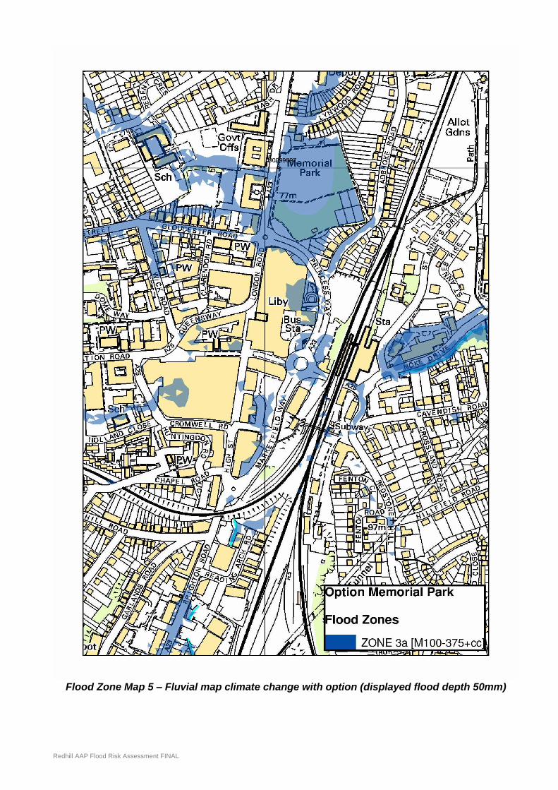
Flood Zone Map 5 – Fluvial map climate change with option (displayed flood depth 50mm)

Redhill AAP Flood Risk Assessment FINAL
Flood Zone Map 6 – Surface Water map with option (displayed flood depth 50mm)

Redhill AAP Flood Risk Assessment FINAL
THIS PAGE LEFT BLANK INTENTIONALLY FOR DOUBLE-SIDED PRINTING

Redhill AAP Flood Risk Assessment FINAL
Appendix E - SFRA EXTRACTS
Reigate & Banstead SFRA Area 2
The 2007 SFRA is currently being updated in 2011. This FRA should be read in conjunction with the revised SFRA once published. The following are extracts from the 2007 version.
Redhill, Earlswood and Merstham
Properties within Brook Road, Bletchingley Close and Weldon Way in South Merstham are potentially at risk of flooding from the unnamed tributary of Redhill Brook in the 1 in 100year design event. A designated corridor has been provided along the waterway within South Merstham (and indeed downstream of the confluence with the main Brook), encompassing much of the natural floodplain of the river. Consequently, a large proportion of the area at risk is within open space, protected from future development by local planning policy16.
A number of localised flooding issues have been highlighted within the areas of Coles Meads and South Merstham, reiterating the importance of sustainable drainage (SuDS) as an integral part of all future development. Once again it is essential to recognise that the localised issues identified in the adjoining maps reflect only those incidents that have been reported to the Council.
South Merstham and Coles Meads are situated at the foot of the North Downs Escarpment, overlaying an area of variable subsoil as outlined in Section 4.7. The permeability of these soils is highly variable, and it is essential that a site based geological investigation is carried out to assess inform the SuDS design. The suitability of (for example) infiltration techniques will be heavily dependant upon the local soil regime. Advice should be sought from the Council in this regard.
Redhill Brook flows through the centre of Redhill, largely in culvert. The capacity of the culvert is relatively limited, and the system is prone to blockage. Consequently, there is a risk of fluvial flooding to properties within Redhill and Earlswood.
Of particular importance from a planning perspective is Redhill town centre, a key regeneration area. The train and bus station precinct and the commercial area adjoining the A23 (Brighton Road) immediately to the south of the railway are the most at risk. Opportunities to minimise this risk through rigorous culvert and gully maintenance, and possibly on site flood storage (introduced as part of the site regeneration) should be sought.
Residential properties within Victoria Road and Emlyn Road in Earlswood are at risk of flooding in the 1 in 100year design event. There are no known observations of flooding within this area, and it would appear that the source of this flood risk is the surcharging of the Redhill Brook culvert. As a result, improvements in the system upstream (during regeneration of the town centre) may alleviate this risk to some degree. The natural floodplain of Redhill Brook downstream is situated within open space, protected from future development by local planning policy. The loss of this floodplain will further exacerbate the potential risk of flooding to properties within Earlswood.
Finally, a number of localised flooding issues have been identified within Redhill (as notified to Reigate & Banstead Borough Council). Redhill and Earlswood are situated at the foot of the North Downs, underlain by soils of varying permeability. As highlighted above, it is essential that the proposed drainage system considers the local geology to ensure that the adopted SuDS provide a sustainable solution for the lifetime of the proposed development. At all locations, it will be necessary to consider the potential impacts of an extreme 1 in 100 year plus climate change storm event (i.e. that exceeds the capacity of the designed drainage system). It is imperative that the excess overland flow can be managed in a controlled manner without posing a risk to property.