appendix b landfill inspection forms and survey data · this page intentionally left blank . ......
TRANSCRIPT

Appendix B
Landfill Inspection Forms and Survey Data

This page intentionally left blank


This page intentionally left blank

Original Landfill January 2011 Monthly Inspection – Attachment 1 The January inspection of the OLF was completed on January 28. The cover was fairly dry at the time of the inspection as precipitation has been scarce during the entire month. No new cracks were observed during this inspection. The locations where the previously reported cracks had been filled and compacted were also still in good repair. Project Location Updates Berm 1 and 7 continue to look good with no new slumping or cracking present. The Western Perimeter Channel is still in good shape. The vegetation is dormant this time of year, but will be coming back in the next few months.
Eastern Perimeter Channel
Seeps The Seep 1 area was dry as usual. The Seep 2 and 3 areas were also dry. The Seep 4 and 5 areas had some surface expression. The Seep 6 area has three locations located above berm #7 that were all dry. The Seep7 area is still dry. There is still wetland vegetation present in the upper and lower Seep 7 locations. Surface flow at Seep 8 has slowed significantly to approximately 1-2 gpm. Pictures of the main seep locations are included below.
Seep 4 and 5 Area

Seep 7 Area

Seep 8 Cracks The crack locations above the EPC and east of the the buttress that were repaired following the November 2010 inspection are still in good condition. No new cracks were observed in these areas during the January inspection. Slumps There were no changes to the slump that was observed on the eastern slope of the EPC towards the top of the channel during the November 2010 inspection. We will continue to monitor the slumping area for any changes during routine and non-routine inspections of the OLF.


This page intentionally left blank

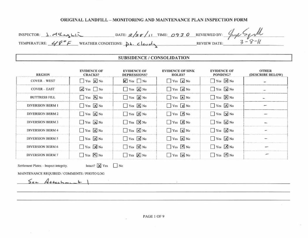
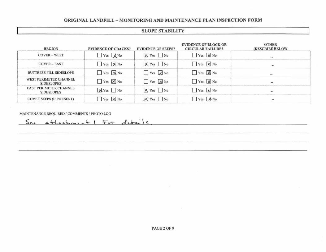
Original Landfill February 2011 Monthly Inspection – Attachment 1 The monthly inspection of the OLF was completed on February 28. The cover was dry at the time of the inspection as precipitation continues to be scarce. Some cracking was observed at the top of the East Perimeter Channel (EPC) in the same location as previously reported cracks. The cracks will be filled and compacted per requirements of the OLF Monitoring and Maintenance Plan when the cover thaws out little more. The slump in the EPC is continuing to move very slowly. The slumping material is not significantly impeding the flow capacities of the EPC at this time. We are evaluating a path forward for the EPC slump including possible repairs. Project Location Updates Berm 1 and 7 continue to look good with no new slumping or cracking present.
Berm 1

The Western Perimeter Channel is still in good shape. The vegetation is still dormant, but will be coming back in the next few months.
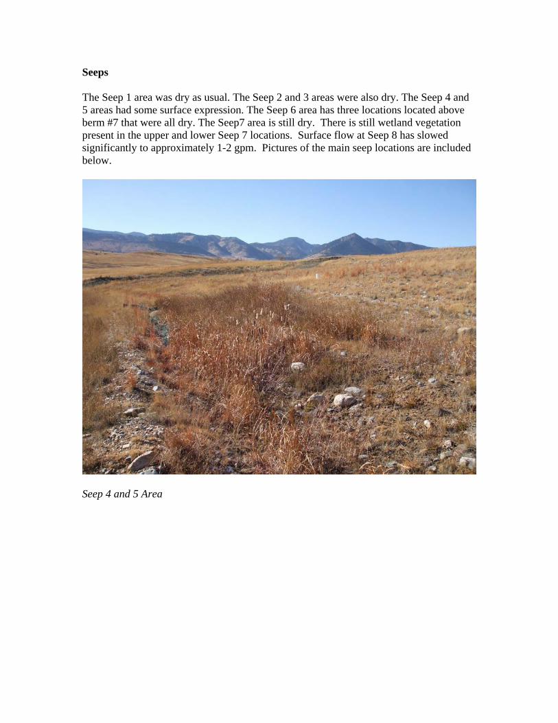
West Perimeter Channel Seeps The Seep 1 area was dry as usual. The Seep 2 and 3 areas were also dry. The Seep 4 and 5 areas had very little surface expression and are as dry as have been observed over the last several years. The Seep 6 area has three locations located above berm #7 that were all dry. The Seep7 area is still dry. Surface flow at Seep 8 continues to flow at a significantly reduced rate of approximately 1-2 gpm. Pictures of the main seep locations are included below.

Seep 4 and 5 Area
Seep 7 Area

Seep 8 EPC Slump The slump that was observed on the eastern slope of the EPC towards the top of the channel continues to slowly develop. The location of the slump has been recorded with a GPS unit and data is being updated on a quarterly basis. There is no vertical displacement being observed at this time. We will continue to monitor the slumping area for any changes during routine and non-routine inspections of the OLF.

EPC Slump Area

This page intentionally left blank


This page intentionally left blank

Original Landfill March 2011 Monthly Inspection – Attachment 1 The monthly inspection of the OLF was completed on March 30. The cover was dry at the time of the inspection as we have had unusually low amounts of precipitation for the month of March. The cracks that were filled following last months inspection are still in good shape. No new cracks were observed. The slump in the EPC appeared to be unchanged. As stated in previously submitted reports, the slumping material is not significantly impeding the flow capacities of the EPC at this time. Project Location Updates Berm 1 and 7 continue to look good with no new slumping or cracking present.
Berm 1 The Western Perimeter Channel is still in good shape. The vegetation is just starting to grow again.

West Perimeter Channel Seeps The Seep 1 area was dry as usual. The Seep 2 and 3 areas were also dry. The Seep 4 and 5 areas had very little surface expression. The Seep 6 area has three locations located above berm #7 that were all dry. The Seep7 area is still dry. Surface flow at Seep 8 continues to flow at a reduced rate of approximately 1-2 gpm. Pictures of the main seep locations are included below.

Seep 4 and 5 Area
Seep 7 Area

Seep 8 EPC Slump The slump that was observed on the eastern slope of the EPC towards the top of the channel appears to be unchanged. The location of the slump has been recorded with a GPS unit and data is being updated on a quarterly basis. We will also be installing stakes delineating the perimeter of the slumping area to help evaluate any future movement. There is no vertical displacement being observed at this time. We will continue to monitor the slumping area for any changes during routine and non-routine inspections of the OLF.

EPC Slump Area

This page intentionally left blank


Rocky Flats SiteOriginal Landfill - Settlement Plates Monitoring Quarterly Survey March 23, 2011 Comparison to Previous December 22, 2010
03-23-11 OBSERVATIONS DELTA DELTA DELTA 12-22-10 OBSERVATIONSPOINT NUMBER NORTHING EASTING ELEVATION DESCRIPTION NORTHING EASTING ELEVATION POINT NUMBER NORTHING EASTING ELEVATION DESCRIPTION
13500 747913.69 2082233.07 6005.89 N RIM PIPE AA 0.01 0.02 0.05 13442 747913.70 2082233.09 6005.93 N RIM PIPE AA13507 747644.91 2081851.20 5975.35 N RIM PIPE BB 0.04 -0.02 -0.04 13467 747644.95 2081851.19 5975.31 N RIM PIPE BB13506 747883.31 2081666.06 6019.59 N RIM PIPE CC 0.01 0.03 0.01 13452 747883.31 2081666.09 6019.60 N RIM PIPE CC13503 747803.45 2081642.35 6006.08 N RIM PIPE DD 0.00 0.01 0.01 13453 747803.45 2081642.36 6006.09 N RIM PIPE DD13502 747700.77 2081620.51 5988.51 N RIM PIPE EE -0.01 0.01 0.00 13449 747700.76 2081620.53 5988.51 N RIM PIPE EE13504 747704.41 2081406.94 5997.16 N RIM PIPE FF -0.03 0.00 0.01 13458 747704.38 2081406.94 5997.17 N RIM PIPE FF13501 747563.10 2081656.31 5974.17 N RIM PIPE GG -0.03 0.03 0.00 13447 747563.08 2081656.34 5974.17 N RIM PIPE GG13505 747741.64 2081226.20 6013.16 N RIM PIPE HH -0.08 0.02 0.00 13461 747741.56 2081226.22 6013.15 N RIM PIPE HH
DELTAS ARE CALCULATED AS THE DIFFERENCE BETWEEN THE 03-23-11 OBSERVATION AND THE 12-22-10 OBSERVATION
POINTS ARE GRID BASED COLORADO STATE PLANE COORDINATE SYSTEM, CENTRAL ZONE, NAD 27, NGVD 29