appendix c geologic and geotechnical reports for the eagle ... · ljs\j:\scopes\04w018\10000\fvd...
TRANSCRIPT

LJS\J:\scopes\04w018\10000\FVD reports\Final MPA\r-Mine Permit App appendix.doc
Appendix C
Geologic and Geotechnical Reports
for the Eagle Project

LJS\J:\scopes\04w018\10000\FVD reports\Final MPA\r-Mine Permit App appendix.doc
C-1
Geology of the Eagle Nickel-Copper Deposit

Kennecott Exploration
THE GEOLOGY OF THE
EAGLE NICKEL-COPPER DEPOSIT MICHIGAN, USA
Prepared for: Kennecott Minerals Co.
Prepared by: Dean Rossell and Steven Coombes April 29, 2005

CONTENTS
Summary........................................................................................................................................ 1
Introduction................................................................................................................................... 2
Location and Access.................................................................................................................... 2
Physiography .............................................................................................................................. 3
Climate ........................................................................................................................................ 3
Vegetation and Land Use ............................................................................................................ 3
Land Ownership.......................................................................................................................... 4
Exploration History..................................................................................................................... 4
Regional Geologic Setting............................................................................................................. 5
Archean ....................................................................................................................................... 6
Paleoproterozoic ......................................................................................................................... 7
Paleoproterozoic ......................................................................................................................... 8
Mesoproterozoic.......................................................................................................................... 8
Paleozoic ..................................................................................................................................... 9
Local Geology .............................................................................................................................. 10
Lithology ................................................................................................................................... 10
Structure.................................................................................................................................... 11
Eagle Deposit Geology ................................................................................................................ 12
Nomenclature ............................................................................................................................ 13
Lithology ................................................................................................................................... 14 Sedimentary Units................................................................................................................. 14 Intrusive Units....................................................................................................................... 16
Alteration .................................................................................................................................. 17
Structure.................................................................................................................................... 18
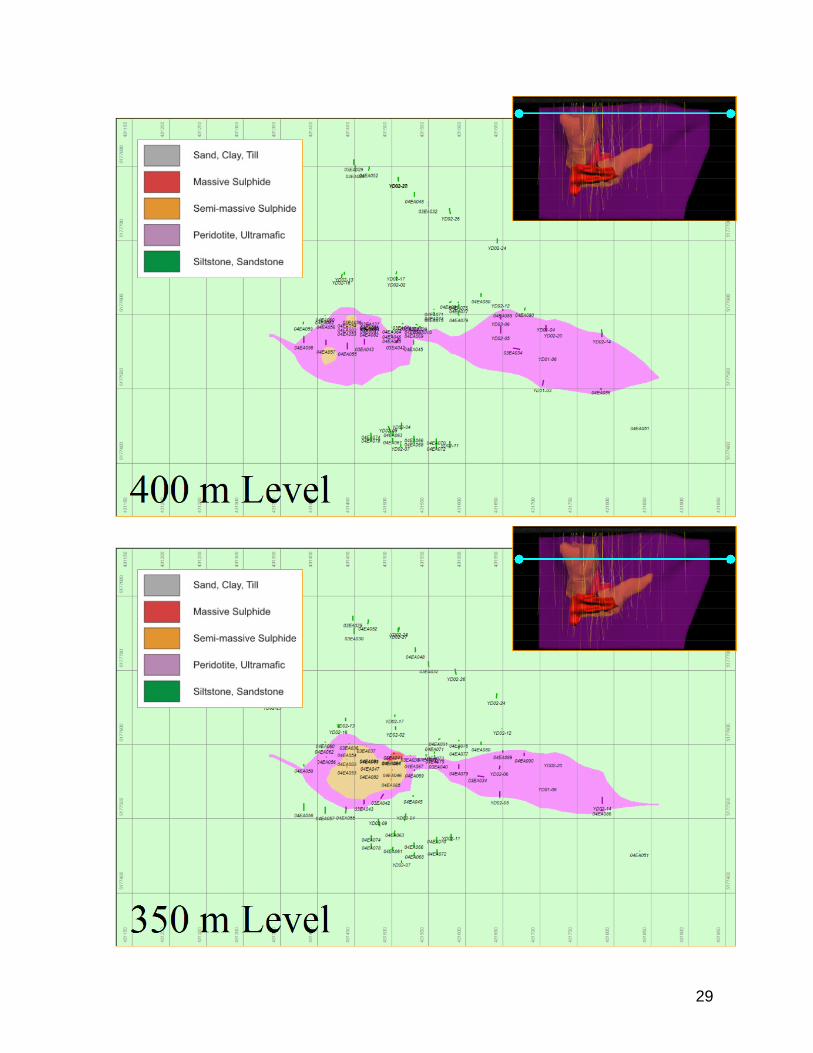
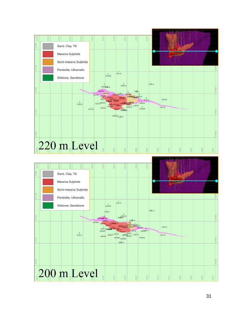
Economic Mineralization.......................................................................................................... 20 Disseminated Sulfide ............................................................................................................ 20 Semi-Massive Sulfide (SMSU)............................................................................................. 21 Massive Sulfide (MSU) ........................................................................................................ 21
Metal Distribution..................................................................................................................... 33
References .................................................................................................................................... 33

3

Summary The Eagle property is the subject of a Pre-Feasibility Study. Eagle is a high-grade magmatic sulfide deposit containing nickel and copper mineralization with associated cobalt, platinum, palladium and gold. The most recent geologic resource estimate is 4.05 million tonnes with an average grade of 3.57% Ni, 2.91% Cu, 0.10% Co, 0.28 gpt Au, 0.73 gpt Pt, and 0.47 gpt Pd. The project is located in Marquette County, Michigan, USA. The project is 100% owned and operated by Kennecott Eagle Minerals Company with retained NSR royalties held by the state of Michigan and various private interests. Kennecott Exploration Inc. first drilled the Eagle deposit in 2001 but massive sulfide was not discovered until July 2002. The discovery was made by drilling magnetic anomalies associated with known sulfide bearing peridotite intrusions as part of a regional nickel exploration effort. Drilling by Kennecott Exploration in 2002 and 2003 further defined the extent and grade of mineralization at Eagle. An Order of Magnitude study was completed following the 2003 drilling and the Eagle project was passed on to Kennecott Minerals Co. in early 2004. Kennecott Minerals conducted an extensive drill program at Eagle in 2004 to further evaluate the project to a pre-feasibility level. Surface drilling was completed in 2005. Only minor modifications to the existing block model were required. An updated grade and tonnage block model should be available by the end of 2005. It is not anticipated that the tonnage or grade values will vary more than 5% to those reported above The deposit is located proximal to the Mesoproterozoic Midcontinent rift, a large scale failed continental rift that extends northeast from central Kansas, passes beneath Lake Superior, and turns southward into southern Michigan. The rift is believed to be mantle plume related and is characterized by large-scale volcanism. The peridotite intrusion that hosts the Eagle deposit is part of a picrtitic intrusive event ascribed to an early phase of rift related volcanism. The Eagle perodotite intrudes a thick sequence of Paleoproterozoic pelitic sediments. The Eagle intrusion is the western of two intrusions at the east end of the Baraga Basin. It is only exposed in one outcrop but is readily apparent on detailed magnetics maps of the area. The Eagle intrusion is dominantly peridotite with lesser feldspathic peridotite, gabbro, olivine gabbro and pyroxenite. The intrusion at surface is about 480 meters long by 100 meters wide and has been tested by drilling to a maximum depth of 340 meters below surface. Economic minerals are primarily pentlandite and chalcopyrite in pyrrhotite dominated massive, semi-massive and disseminated sulfides. The geologic resource comprises the massive and semi-massive sulphides only. The resource is bimodal with sharp transitions from massive to semi-massive zones. The semi-massive ore is confined to the host peridotite intrusion while the massive sulphide intrudes both internally as well as penetrating laterally into the surrounding sedimentary rocks. Massive sulfides have an average grade of 6.11% Ni and 4.15% Cu while the semi-massive sulfides average 2.11% Ni and 2.19% Cu.
1

Introduction The geological observations and interpretations in this report are partly based on extensive regional mapping and examination of drill core by Dean Rossell over about 13 years of working in the Baraga Basin. Kennecott Exploration fieldwork at Eagle was directed by Steven Coombes (2001-2002) and Andrew Ware (2003). Geologic fieldwork by Kennecott Minerals Co. (2004-5) was managed by Andrew Ware with technical management and data modeling by Steven Coombes (2003-2005).
Project Location
Location and Access The Eagle property is located in the Upper Peninsula of Michigan, USA at geographic coordinates 46° 44’ 54” north latitude by 87° 53’ 43” west longitude in Michigamme Township, Marquette County. The property is on the watershed divide of Yellow Dog River and Salmon Trout River on the USGS 1:24,000 scale Bulldog Lake quadrangle sheet. Road access to the property is excellent with maintained loose surface and paved roads from the communities of Big Bay to the east, L’Anse to the west, and Marquette to the south. The closest community is Big Bay, 24 kilometers (15 miles) from the property by road. The closest full service community is Marquette, 53 kilometers (33 miles) by road from the property. Marquette provides a commercial airport, rail and shipping facilities, and a full range of commercial services. Kennecott Minerals has an administrative office in Marquette and a field office in Negaunee, 15 kilometers (9.5 miles) west of Marquette.
2

Physiography The property is in the Marquette Highland physiographic region characterized by uplands of variable topography controlled by bedrock. In some areas, the terrain consists of low rocky ridges less than 15 meters (50 feet) high, with many small lakes and swamps. In other areas, like the Huron Mountains, large, exposed ridges of granite or sandstone can be 150 to 250 meters (500 to 800 feet) high. The highest point in the state, Mount Arvon at 603 meters (1979 feet) above sea level, is located in the region. Locally there are thick accumulations of sandy till. Two large outwash plains occur in the region, the Yellow Dog and the Mulligan plains. The northern margin of Yellow Dog plain drops off steeply towards Lake Superior suggesting it formed against the southern margin of a receding ice sheet. The Eagle property is located on Yellow Dog plain where two erosionally resistant knobs of peridotite protrude through the till. Lakes, rivers and smaller streams are numerous. Most of the streams have steep gradients, and many have waterfalls near Lake Superior. Some of the larger streams are the Peshekee, Huron, Little Huron, Dead, Yellow Dog, and Salmon Trout rivers. Climate The region has a continental climate characterized by extreme snowfall along the Lake Superior shoreline and extremely cold winters. Growing season ranges from 75 days in the interior to 150 days along the Lake Superior coast. Extreme minimum recorded temperatures range from –28.5°F (-33.6°C) along the coast to –46.5°F (-43.6°C) inland. Snowfall is heaviest inland, averaging 200 inches, and is least along the coast, averaging 120 to 140 inches. Average annual precipitation is 32 to 36 inches; the heaviest precipitation falls at high elevations inland (USGS, 1998). Vegetation and Land Use Pre-settlement vegetation was predominantly Hemlock, northern hardwoods and white pine. Scattered white pine, red pine, and red oak were the dominant trees on exposed bedrock ridges. Jack-pine forests dominated the outwash sands of the Yellow Dog and Mulligan plains. Balsam fir, tamarack, and black spruce are the most common original species in wetland areas. Logging and mining have been a major part of land use activities for over 150 years. Copper mining on the Keweenaw Peninsula has been conducted since before recorded history. Mining for iron in the Marquette Range created many large open-pit mines and the diversion of creeks and rivers in the southern part of the region has undoubtedly had an impact on associated wetlands either by flooding or removal of water sources. Logging is ongoing throughout the region including recent extensive clear-cutting of second growth Jack-pine forests at Yellow Dog plain. Old-growth forests can still be found in the Huron Mountain Club and parts of the McCormick Tract. Lightning-strike fires have been observed on ridge tops but there is no record of major forest fires. Recreation is an important land use, both along the shoreline and inland. The forested hilly land with lakes and streams attracts hunters, fishermen, hikers and other recreational users. The region is also very popular for snowmobiling in the winter.
3

Agriculture is relatively limited in the western Upper Peninsula because of topography, elevation, and the shortness of the growing season. There is minor commercial fishing of white fish and lake trout along Lake Superior. Urban development is concentrated around Marquette. Land Ownership Kennecott Minerals owns the surface rights at the Eagle property through purchase agreements negotiated with Mead-Westvaco and private landowners. Kennecott Minerals controls mineral rights at Eagle through numerous lease and purchase agreements with the state of Michigan and private interests. Many of the lease agreements have clauses allowing for NSR royalties payable to the lessors. Exploration History The Baraga Basin region has until recently been subject to only sporadic exploration efforts. The earliest historical accounts of exploration in the basin date back to the mid-1800’s when a group of investors tried to develop slate quarries along Slate River. Little documented exploration work took place in the Baraga basin between 1910 and 1950. During the 1950’s Jones and Laughlin conducted an exploration program along the northern portion of the East branch of the Huron River, investigating uranium-silver-mercury mineralization associated with a graphitic shear exposed in the river. During the 1960’s and 1970’s, various interests conducted exploration programs on Ford mineral lands in the Baraga Basin and the western portion of the Marquette Trough. The programs were primarily focused on uranium and zinc. The U.S. Department of Energy provided funding to drill a number of deep holes in the Baraga Basin during the 1970’s presumably to provide stratigraphic information for the uranium exploration effort. Concurrently, the USGS began a bedrock-mapping program of the basin, focusing primarily on exposures in rivers, which produced an open file outcrop map with little interpretation and no report. In 1976, Michigan Technological University drilled a 31-meter hole on the east end of the Yellow Dog (East Eagle) outcrop. The hole bottomed in coarse-grained peridotite with only traces of sulfide. In 1979, the Michigan DNR, in conjunction with the USGS, published a report on the Yellow Dog peridotite describing the results of geochemical, petrographic and geophysical studies of the peridotite (Klasner, et.al, 1979). The authors concluded that the anomalous sulfur and copper contents of the outcropping peridotite indicate a significant potential for copper-nickel ore deposits. Kennecott Exploration started working in the region in 1991 and actively explored for sedex zinc deposits through 1994. During the course of mapping, float boulders of peridotite with sulphides were discovered that indicated the potential for magmatic sulphide mineralization. Kennecott partially shifted to magmatic nickel exploration in 1995 and drilled four holes to test the Yellow Dog peridotite (East Eagle). One hole (YD95-2) intersected 10 meters of moderate to heavy disseminated sulfide mineralization along the southern contact. Two more angle holes (YD95-3 and YD95-4) collared on the east end of the Yellow Dog East outcrop demonstrated the peridotite widened to the east but only intersected a meter or two of weak sulfide mineralization along the north and south contacts.
4

The current nickel exploration program was started late in 2000. Drilling at the neighboring East Eagle target in July 2001 intersected 30 meters of disseminated, semi-massive and massive sulfides averaging 1.03% Ni and 0.75% Cu (YD01-01) and one of three holes on the east end of Eagle intersected 85 meters of disseminated sulphides averaging 0.6% Ni and 0.5% Cu (YD01-06). 2002 drilling at Eagle targeted the center of a magnetic anomaly defined by ground surveys in 2001. The first hole, YD02-02, intersected 84.2 meters of massive pyrrhotite-pentlandite-chalcopyrite averaging 6.3% Ni and 4.0% Cu, firmly establishing the presence of economic grade and width mineralization at Eagle. Subsequent definition drilling continued through the summer and fall of 2002 and resumed in 2003. By the end of 2003 two separate high grade sulfide zones were identified at Eagle. The lower zone was defined by 15 drill intercepts and the upper zone by six drill intercepts. This formed the basis of an Order of Magnitude study that was completed in early 2004 stating a resource estimate of 4.99 million tonnes with an average grade of 3.68% Ni, 3.06% Cu, 0.10% Co, 0.34 gpt Au, 0.84 gpt Pt, and 0.53 gpt Pd. Upon Rio Tinto acceptance of the Order of Magnitude study in early 2004, ownership of the Eagle project was transferred from Kennecott Exploration (RTE) to Kennecott Minerals (Copper Group) for additional evaluation. Kennecott Minerals conducted an extensive resource and geotechnical drill program in 2004 supplying the data to connect the former upper and lower zones and better establish the geometries of the massive sulphide, semi-massive sulphide and host intrusive bodies. The result of this work is a pre-feasibility level resource estimate of 4.05 million tonnes with an average grade of 3.57% Ni, 2.91% Cu, 0.10% Co, 0.28 gpt Au, 0.73 gpt Pt, and 0.47 gpt Pd. The drilling history at Eagle (current 2004 resource definition holes only) by year is:
2001 501 m 3 holes
2002 5,496 m 18 holes
2003 3,784 m 14 holes
2004 11,238 m 42 holes
21,019 m 77 holes
Thirteen additional holes were drilled in 2005. Minimal changes to the 2004 resource and grade block models are anticipated.
5

Regional Geologic Setting The Eagle property is located in the Baraga Basin area on the south side of Lake Superior. Three depositional periods are well represented in the region. These occur in the Archean, Early Proterozoic and Middle Proterozoic and are separated by pronounced unconformities related to major regional tectonic events. Archean The Archean basement rocks exposed in the western portion of the Upper Peninsula are divided into two terranes referred to as the Northern and Southern Complexes. The younger Northern Complex, comprised mainly of gneiss, granitoids and lower metamorphic grade supracrustal rocks, is believed to be the extension of the Late Archean Wawa granite-greenstone subprovince. A tonalitic intrusion dated at 2703 Ma and a rhyolite dated at 2780 Ma (Sims et al., 1993), the only available age dates from the Northern Complex, are comparable to other dates from the Canadian and Minnesota portions of the Wawa subprovince. The Southern complex is comprised of gneiss, migmatite and amphibolite of predominantly Middle Archean age, intruded by scattered weakly foliated to massive Late Archean granitoids. The older gneisses yield ages ranging from 3800-3000 Ma (Peterman et al., 1986) in the western portion of the Upper Peninsula. These ages are comparable to Early-Middle Archean aged gneisses in the Minnesota River Valley. The boundary between the Northern and Southern Complexes is a broad structural zone, of regional extent, referred to as the Great Lakes Tectonic Zone (GLTZ). The GLTZ can be inferred westward at least into western Minnesota and possibly eastward into Ontario. The only known, exposed portion of the GLTZ is located south of the city of Marquette. Kinematic analysis suggests the GLTZ, at this location, dips steeply southward, and that vergence was to the northwest, indicative of an oblique collision that brought the Southern complex over the Northern complex (Sims et al., 1993). Collision along the GLTZ is believed to have occurred between 2692-2686 Ma (Schneider et al, 2002).
Regional Event Chart
6
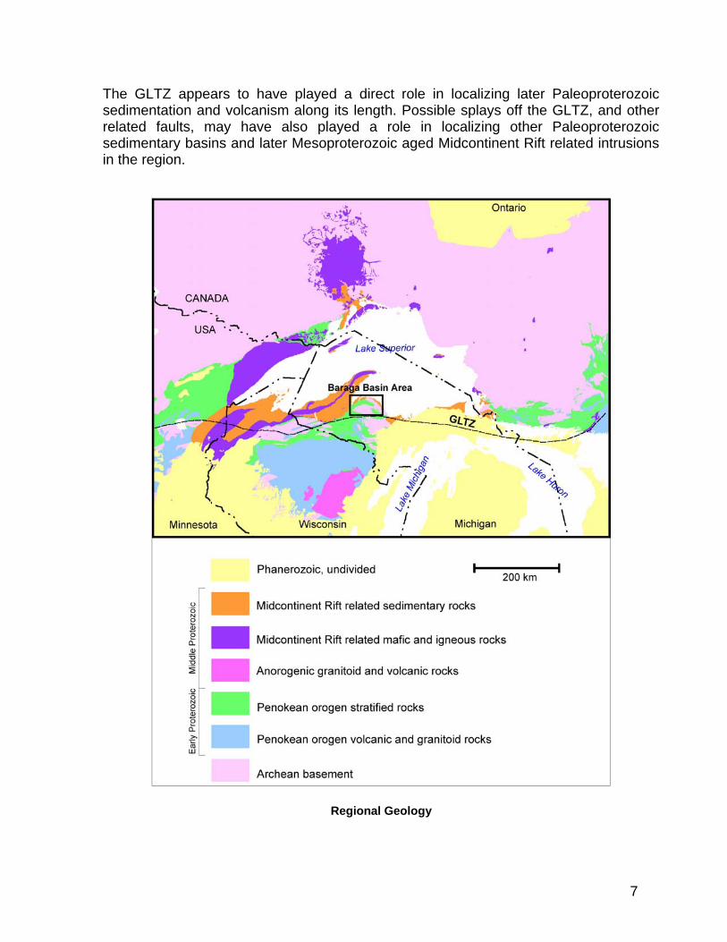
The GLTZ appears to have played a direct role in localizing later Paleoproterozoic sedimentation and volcanism along its length. Possible splays off the GLTZ, and other related faults, may have also played a role in localizing other Paleoproterozoic sedimentary basins and later Mesoproterozoic aged Midcontinent Rift related intrusions in the region.
Regional Geology
7

Paleoproterozoic The assemblage of Paleoproterozoic sediments and volcanics resting unconformably on Archean basement in the Upper Peninsula, are collectively referred to as the Marquette Range Supergroup (MRS). The MRS is subdivided, from oldest to youngest, into the Chocolay, Menominee and Baraga groups, all separated by angular unconformities. The Chocolay group, an assemblage of quartzites, carbonates and possible tillites, appears to be correlative with the uppermost formations of the 2.4-2.2 Ma Huronian Supergroup in Ontario (Laberge et al., 2003) . The Menominee and Baraga groups, comprised of quartzites, iron formations, volcanic rocks and turbidites, are generally thought to correlate with younger Paleoproterozoic sequences in Wisconsin and Minnesota. However, regional and local stratigraphic correlations are severely hampered by structural complexity, poor exposure in critical areas, and a lack of age dating. These complexities have resulted in many conflicting interpretations and assignments. The MRS is bounded to the south by Paleoproterozoic volcano-plutonic, arc-related orogenic rocks of the Wisconsin Magmatic Terrane (WMT). The Niagara fault zone, the structural zone that separates the two terranes, is widely believed to be the suture of a southward dipping subduction zone that carried the southern edge of the Superior craton beneath the WMT arc complex. The accretion of the WMT (and possibly one or more other terranes) to the southern edge of the Superior craton (the Penokean orogeny) is believed to have occurred between 1875-1835 Ma. Recently reported, high-resolution U-Pb zircon dates of volcanics within the Menominee and Baraga groups of 1874 Ma and 1878 Ma are significantly younger than expected (Schneider et al, 2002). This has led to speculation that both the Menominee and Baraga groups were deposited in an extensive foredeep essentially coeval with arc accretion. The southern portion of this foredeep was incorporated into a north verging, fold and thrust belt that extends westward from Michigan into central Minnesota, and may have incorporated portions of the older Huronian sequence in Ontario. The formation of mantled gneiss domes and intrusion of numerous post tectonic granitoids along the length of the fold and thrust belt may have been triggered by the eventual gravitational collapse of the orogen. Mesoproterozoic The Keweenaw Flood Basalt province represents the exposed portion of the Midcontinent Rift system in the Lake Superior region. The Midcontinent Rift forms a prominent gravity anomaly (Midcontinent gravity high) that can be traced southwest from the Lake Superior region into central Kansas and southeastward into southern Michigan. The total length of the geophysical feature is in excess of 2000 km (Hinze et al, 1997). Seismic data indicates the rift below Lake Superior is filled with more than 25km of volcanics buried beneath a total thickness of up to 8km of rift filling sediments (Bornhorst et al, 1994). The estimated volume of magmatic rocks associated with the rift is greater than 2 million cubic kilometers (Cannon, 1992). The Keweenaw Flood Basalt province was formed over an approximately 23 million year period, from ~1111 ma. to ~1089 ma (Miller,1996). Volcanism was bimodal, but with preserved basaltic rocks much more abundant than rhyolitic rocks. Volcanism
8

occurred in two distinct phases, with an approximately 5 million-year hiatus between phases. In Michigan and Wisconsin the early phase volcanics are comprised of the Siemans Creek and Kallander Creek Volcanics. The Portage Lake volcanics comprise the younger phase. The Siemans Creek and Kallander Creek volcanics are primarily reversely polarized. The Portage Lake volcanics are normally polarized. A mantle plume model has been widely evoked to explain the staged evolution and large volume of magmatic products associated with the Midcontinent Rift. (Nicholson, 1997). The evolution of the Midcontinent Rift closely resembles that of other large igneous provinces such as the North Atlantic Igneous province and the Siberian Traps. In the North Atlantic Igneous province, picritic volcanics, associated with an early phase of plateau like flood basalts, are spread out over an area 2000 km across (Larsen et al., 2000). In the Keweenaw Flood Basalt province, much of the relatively thin veneer of early phase flood basalts were eroded away from the flanks of the evolving Midcontinent rift as they were uplifted. The removal of the flanking flood basalts is reflected by an upward change in clast composition in the rift filling sediments, from basalt dominated to more basement lithology dominated assemblages. Erosion along the flanks of the rift exposed a number of dike swarms and sills, which might have served as the feeder system for the early phase basalts and picrites. A pronounced compressional phase terminated the formation of the Midcontinent Rift. This event resulted in the transformation of original graben bounding normal faults into reverse faults. Seismic data suggests that as much as 15 km of reverse movement may have occurred along the Keweenaw Fault in the Western Upper Peninsula. Rift flanking basins were filled with up to 3 kms of sediment shed off the resulting horst (Jacobsville Sandstone). Thermal modeling suggests this compressional event, a possible far field effect of the Grenville orogeny, may have started as early as 1080 Ma and was likely completed by 1040 Ma (Bornhorst et al., 1994). Paleozoic Paleozoic sediments in the eastern half of the Upper Peninsula cover the Precambrian basement. These gently south-southeast dipping sediments form the northern edge of the large Michigan Sedimentary Basin.
9

Local Geology The Eagle deposit is located at the east end of the Baraga Basin, the northern-most basin of Paleoproterozoic sediments in Michigan. The host intrusions are part of the Mesoproterozoic Baraga-Marquette dike swarm. The geology of the Baraga Basin is based principally on geologic mapping and drilling by Kennecott Exploration over the last 13 years. Because of the very limited outcrop in the Baraga Basin much of the following geology is speculative.
Distribution of Archean (pink), Paleoproterozoic (green) and Mesoproterozoic (brown) with grey
scale DEM in the Baraga Basin area.
Lithology The roughly boomerang shaped area of exposed and inferred Paleoproterozoic sediments in the Baraga Basin is approximately 50 km long and up to 15 km wide. It is bounded, in part, to the north and south by late Archean gneiss and granitoids of the Northern Complex, and to the east and southeast by Late Archean, less metamorphosed volcanic and sedimentary rocks of the Marquette-Ishpeming Greenstone belt. The Baraga basin is separated from the larger, Paleoproterozoic Michigamme Basin to the southwest, by a broad area of phyllites and mylonites, informally designated (by Kennecott Exploration) as the Taylor Creek phyllites. The abrupt, roughly east-west trending, northern termination of the Taylor Creek phyllites, near L’Anse, Michigan, is referred to as the L’Anse Discontinuity. This boundary is
10

inferred to be the northern limit of thick-skinned thrusting associated with the Penokean fold and thrust belt. Drilling in the Archean, to the immediate south of the Baraga Basin, has shown that at least a portion of the Archean basement has been thrust over Paleoproterzoic sediments. The Mesoproterozoic Jacobsville sandstone basin covers the extension of the Baraga basin to the northwest. In the few locations where the base of the Paleoproterozoic section is exposed in the Baraga Basin, sediments rest unconformably on Archean crystalline basement. This differs from basins further to the south where most of the observable contacts with Archean basement are faults. Although not directly traceable into the type areas for the Marquette Range Supergroup, Paleoproterozoic sediments of the Baraga Basin are all generally believed to belong to the Baraga Group. The Baraga group sediments in the Baraga Basin appear to be comprised of two, stacked, generally upward fining sequences. Each of the two upward fining assemblages is capped by up to 300m of carbonaceous slate with 1 to 10% sulfide (the lower and upper slate horizons are informally referred to as the Lower Slate and Lower Fossum Creek units respectively). Each of the thick carbonaceous slate horizons contains thinner horizons of metalliferous slate with highly anomalous concentrations of zinc, nickel, and other metals. The total thickness of sediments forming these two upward fining cycles, near the center of the basin where they are best exposed, is crudely estimated to be between 1000 and 1500m. Locally at the top of the uppermost, upward fining cycle of sediments (top of the Lower Fossum Creek unit), is an approximately 30m thick horizon of sulfide rich graphitic schist with multiple generations of deformed quartz veins. This horizon, informally named the Deformation Zone, is laterally extensive and folded at a variety of scales. The Deformation Zone, which has been variously interpreted as a folded thrust fault or as localized deformation along a susceptible exhalite horizon, is one of only a very few distinctive marker horizons in the Baraga Basin sedimentary package. The Deformation Zone is overlain by an assemblage of interbedded pelitic and arenacous sediments, with the general characteristics of turbidites, informally designated the Upper Fossum Creek unit. The Upper Fossum Creek unit has not been identified in the far western portion of the Baraga Basin. Although, poorly constrained, the preserved portion of the Upper Fossum Creek unit appears to thicken eastward from the center of the Baraga Basin toward the Eagle deposit, where it may be in excess of 500m. If this is correct, the total thickness of Paleoproterozoic sediments in the eastern Baraga Basin, in the vicinity of The Eagle Prospect, could be greater than 2000m. Structure Paleoproterozoic pelitic sediments have a well-developed slaty cleavage in the Baraga Basin. The strike of the principal slaty cleavage (S1 foliation) averages 109° (250 measurements) and shows very little variation across the exposed portions of the basin. The dip of S1 is consistently to the southwest and varies from 40-45° in pelitic beds to 50-60° in sandy beds. The S1 foliation is approximately axial planer to numerous small-scale folds exposed in the basin. Small-scale folds are mostly upright with amplitudes and wavelengths that vary from a few meters to a few tens of meters. The small-scale folds are asymmetrical with the north limbs of anticlines generally dipping steeply
11

northward, or in rare cases slightly overturned. The overall sense of vergence is northward. A set of larger scale folds is evident from map patterns. These folds, which form domal patterns with wavelengths of hundreds of meters, appear to be more symmetrical than the small-scale folds. A rarely seen crenulating cleavage (S2 foliation) is approximately coaxial with S1, but typically has a near vertical dip. The S2 foliation may be related to the larger scale folds. Some outcrops have one or more prominent joint sets. The two most prevalent orientations are 020-030° and 090°. Joint patterns often align with stream patterns suggesting they have exerted some control over drainage development. The NE striking set also align with a prominent striping pattern in the airborne magnetic data. The striping is believed to be the result of hydrothermal fluid flow along fractures or faults resulting in the overprinting (sulfidation) of the original syngentic magnetic pyrrhotite in sediments with non-magnetic pyrite.
Eagle Deposit Geology The Eagle deposit is hosted by two peridotite intrusions historically known as the Yellow Dog Peridotites. The eastern intrusion forms a prominent outcropping that rises above the Yellow Dog Plains and is being evaluated by Kennecott as the East Eagle target. The western intrusion, 650 meters to the west and host to Eagle, is only poorly exposed in a small outcrop on the north side of Salmon Trout River. The intrusions are characterized by very prominent magnetic highs relative to the surrounding sedimentary rocks. Drilling at East Eagle identified nickel and copper rich massive, net-textured and disseminated sulfide mineralization concentrated along intrusion boundaries but economic quantities have yet to be located. The entire area is covered by sandy till deposited in an outwash plain. Till thickness ranges from 0m at the peridotite outcrops to in excess of 60m. Drilling in the wetland area directly above the Eagle peridotite indicates a till thickness of 10 to 12m. The till was locally reworked by later fluvial action into broad meandering stream channels. Post-glacial isostatic rebound has tilted the till plain gently to the south concentrating present day streams and associated wetlands along the southern edge of the plain. Low east-west trending sand ribs are interpreted to be pre-vegetation dune deposits.
12

Eagle Area Geology
Nomenclature A variety of classification systems have been proposed over the years for mafic and ultramafic rocks. For the Eagle project, Kennecott adopted the system currently used by the Minnesota Geological Survey (Miller et al., 2002). This system differs from others in that it raises the maximum threshold for plagioclase content for peridotites from the traditional 10-20% to 30%. This was done to accommodate natural modal populations recognized in other Midcontinent Rift related intrusions. This classification seems to work well for the Yellow Dog peridotites, where plagioclase distribution is often patchy and irregular. A limited quantity of major oxide analyses of Yellow Dog Peridotites suggests that rocks visually described as peridotites or feldspathic peridotites would also be classified as ultramafic rocks based on chemistry alone. For the purposes of logging, Olivine rich rocks with less than 10% plagioclase are termed peridotite. Olivine rich rocks with 10-30% plagioclase are labeled feldspathic peridotite. Pervasive alteration complicates modal classification of rock types at Eagle. Because of the difficulty in visually distinguishing pyroxene species, and accurately estimating pyroxene to olivine ratios, no attempt has been made to further subdivide the peridotites (i.e. lherzolites vs wherlites). In thin section peridotite samples are lherzolites or feldpathic lherzolites.
13

Lithology Sedimentary Units The peridotites intrude siltstone assigned to the Upper Fossum Creek unit. The upper parts of the siltstone sequence are competent, light to medium grey and mostly thick bedded, with minor fine grained turbiditic greywacke sandstone interbeds (up to a few meters thick). Minor soft-sediment deformation features such as flame structures, slumping, and rip-ups are common. There are infrequent thin laminated horizons or interbeds. Syngenetic sulphide is typically pyrite with minor pyrrhotite as thin laminae. Foliation in the sedimentary sequence is a dominant feature that forms the weakest planar orientation. Near the hangingwall contact to the Eagle peridotite (within 10 to 20m) foliation in the rock is not visible and the rock becomes weakly hornfels altered. More proximal to the contact (0 to 5m) hornfels alteration is fairly strong, although the protolith can usually still be identified. Small-scale folds are both post-foliation (though pre-mineral?) and syn-foliation. Other notable features in the upper siltstone are one to two thin 10-20 cm banded quartz-silica beds that may be useable as markers within the Eagle deposit area. The sediments are up-right and slightly tilted dipping 10 to 25° to the east-northeast. A lower sequence (seen deeper and lateral to the intrusions) is defined by a dominance of dark grey to nearly black thin laminated slates/shales, syngenetic sulphide laminae (pyrite < pyrrhotite), medium grey thin bedded siltstone, and rare fine grained turbiditic sandstone. Subtle soft sediment structures are present in the lower sequence. Foliation is absent within 5-10 m of the peridotite contacts and is less obvious in the dark shales than in the upper grey siltstone, though visibly present. This sequence has been tentatively assigned to the Lower Fossum Creek unit in some Eagle drill logs but is more likely a portion of the Upper Fossom Creek unit. The closest outcrop of sedimentary rocks is 10 kilometers to the west of Eagle at the Huron River.
14

Eagle Drill Plan and Long Section based on 1995 to 2004 Drilling
15

Intrusive Units In outcrop, both the eastern and western peridotites have distinctive, reddish brown, pitted weathered surfaces with rare bright red patches indicating oxidized pyrrhotite blebs. Weathering rinds are typically less than a centimeter thick, and relatively fresh looking sulfides can be seen within a few millimeters of the surface. Two primary lithologies, peridotite and pyroxenite, are recognized within both intrusions
Peridotite Medium to coarse-grained, massive peridotite and feldspathic peridotite are the most common rock types and form the cores of both intrusions. The peridotite in the cores of the intrusions lacks obvious layering, banding or foliation. In hand sample the peridotite is dark greenish gray on fresh surfaces. In core, feldspathic peridotite can have a mottled white and dark gray color (salt and pepper). In thin section, the peridotite is comprised of 30-60% olivine. The olivine typically occurs as 2-5mm round to ovoid grains. Textural evidence suggests that olivine is an early cumulate phase (Klasner et al., 1979). Chrome spinel occurs as inclusions in olivine suggesting that it is also an early cumulus phase. Megacrystic and glomeroporphyritic olivine have also been noted, indicating that there might be multiple generations of olivine. Pyroxene makes up 25-45% of the peridotite. Clinopyroxene is slightly more abundant than orthopyroxene in most samples. Both clinopyroxene and orthopyroxene are typically poikiolitic or subpoikiolitic to olivine with pyroxene oikiocrysts up to a centimeter across. USGS geologists in an early study (Klasner et al., 1979), described euhedral orthopyroxenes that could have also formed as an early cumulate phase. Anhedral plagioclase forms an intermediate to late intercumulus phase. In many places the plagioclase is patchy, but over some significant intervals it can average 25-30% (feldspathic peridotite). Other probable late intercumulus minerals include biotite, which can average up to a few percent, some possibly minor primary amphibole, Fe-Ti oxides, and sulfides. Early microprobe work on samples of unmineralized peridotite showed olivine compositions ranged from Fo79-82 with NiO contents from 0.24-0.49% (Morris, 1977). A negative correlation between MgO and NiO contents in olivines could be an indication of subsolidus re-equilibration with co-existing sulfides (A. Naldrett, personal communication). Clinopyroxenes have the compositions of low chrome diopside, with Cr2O3 contents ranging from 0.46-1.02%. Orthopyroxene’s are compositionally enstatites. Plagioclase compositions range from An57-65 (Klasner et al., 1979).
Pyroxenite In drill hole YD01-01 (East Eagle), near the lower contact, the core alternates rapidly between intervals of coarse-grained peridotite and a much finer-grained, less magnetic rock. Similar patterns of alternating intervals of coarse-grained peridotite and fine-grained rock were observed near the contacts in mineralized portions of Eagle. Subsequent drilling indicates that some, or possibly all, of the fine-grained intervals may
16

be xenoliths of an earlier phase(s) of the intrusion that have been mechanically incorporated into the peridotite. A similar fine-grained rock has also been noted along the contacts with the surrounding sediments in both intrusions. Primary mineralogy is difficult to infer in these fine-grained intervals. Magnetic susceptibility was often used as an aid in estimating original primary olivine content. This assumes that the bulk of the magnetite forms during the serpentinization of primary olivine. When the primary mineralogy is not obvious, core with relatively low magnetic susceptibility is often assumed to be pyroxenite. Only a few thin sections of the pyroxenites have been made to date. In thin section, most primary silicates have been altered to secondary assemblages. Based on relict textures, estimated original olivine contents ranged from 3-10% (Jago, 2002). This is significantly less than the peridotites, and consistent with their low magnetic susceptibility. Pyroxenes were the predominant primary mineral phase in these sections. However, in one sample, feldspar was estimated at 35-40% indicating possible compositions for pyroxenite might range from pyroxenite to olivine melagabbro.
Dikes A number of thin dikes, ranging from less than a meter to a few meters in width, have been noted in drilling in close proximity to the Yellow Dog intrusions. Little is known about the extent, orientation or composition of these predominantly fine-grained dikes. One thin section, taken from a thin dike along the margin of the massive sulfide intersection in YD02-02, was described as being re-crystallized (hornfelsed) and comprised of secondary minerals with no obvious primary mineralogy preserved (Jago, 2002). This suggests that at least some dikes predate the main stages of intrusion of the peridotite and massive sulfides. High chrome values (>500ppm) for some of these dikes suggest that they are related to the other picritic dikes in the Baraga Basin. Thin dikes have been noted at the contacts of massive sulfide horizons peripheral to both Yellow Dog intrusions. These dikes may have formed barriers, or zones of weakness, that played a role in localizing later massive sulfide mineralization external to the main intrusions. Drilling identified two larger gabbroic dikes to the immediate south of the Yellow Dog intrusions. The dikes correspond with a paired, linear magnetic low and magnetic high that can be traced for several kilometers. The dikes have traces of pyrite and chalcopyrite, but very low values of chrome and nickel. They resemble other gabbroic dikes of the Baraga-Marquette dike swarm Alteration All samples of the two intrusions show evidence of significant, but variable degrees of alteration. Alteration includes; serpentinization of olivine and to a lesser degree pyroxene, alteration of pyroxene to secondary amphibole (uralitization), chloritization of amphibole, chloritization and sausseritization of plagioclase, and minor talc-carbonate alteration (Klasner et al., 1979). Serpentine variably replaces olivine in unmineralized and weakly to moderately mineralized peridotite. Lizardite, the low temperature serpentine polymorph, is the only species identified to date (Jago, 2002). Olivine in semi-massive and massive ores is
17

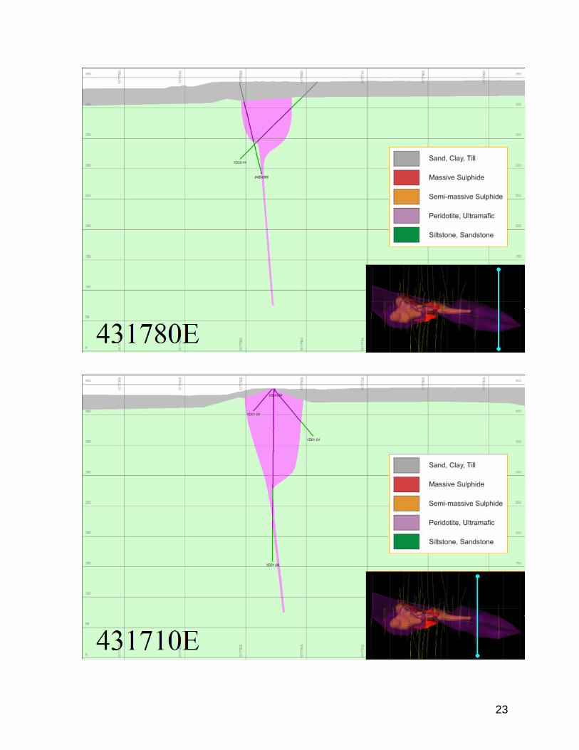
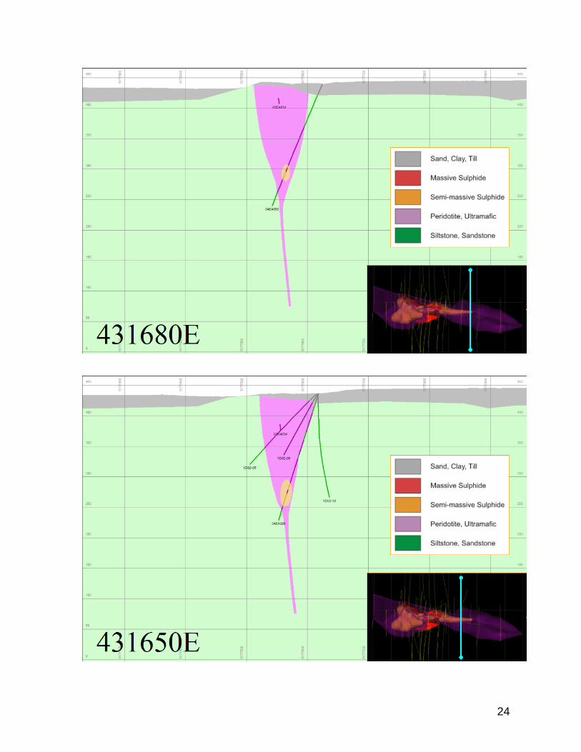
completely serpentinized and anecdotally, it has been noted that serpentine veins and alteration appear to increase toward the SMSU. This has not been rigorously tested or documented. Serpentinization of olivine may have had important effects on the Eagle deposit. Nickel released during serpentinization would preferentially partition into sulfide. This may, in part, account for the very high nickel grades seen at Eagle. Reducing conditions during serpentinization may also be responsible for the traces of native copper and native nickel iron alloys (awurite) observed. Mass loss, and possibly some volume change, during serpentinization also significantly reduced the density of the peridotite. Paleomagnetic studies indicate the original magnetic remenance of the Yellow Dog Peridotite intrusions was reversed. The present strong positive magnetic anomaly produced by the intrusions may result, in part, from secondary magnetite formed during a serpentinizing event during a later period of normal polarity. Metasediments along the margins of the two intrusions are intensely hornfelsed and metasomatized for up to several meters from the contact. Re-crystallization in these zones of intense hornfelsing often obliterates much of the original sedimentary fabric. Little is know about the mineralogy of the hornfelsed zones. Two thin sections of hornfels, from within a meter of the intrusion- sediment contact, are comprised of mixtures of quartz, iron rich chlorite, amphibole and plagioclase (Jago, 2002). Secondary iron oxides give zones of intense hornfelsing a reddish color. Thin veinlets of reddish feldspar and quartz are present in some locations. A fine-grained spotting can be seen in the metasediments for some distance beyond the zones of intense hornfelsing. The spots are variably comprised of pyrite, chlorite and some places a fine-gained white mica. The spots might be altered cordierite porphyroblasts. Structure The intrusion hosting Eagle is elongate east-west with a maximum length of 480 meters and maximum width of about 100 meters near surface. The intrusion narrows to about 10 meters wide at the limit of drilling 340 meters below surface (90m RL). Drilling at Eagle in 2003 and 2004 included holes from which oriented core measurements were obtained. In general, the sedimentary rocks immediately adjacent to Eagle show a fairly consistent bedding orientation with an average strike of 340° dipping 15° to the east. Foliation, like bedding, is fairly consistent with an average orientation striking 100° and dipping 40 to 45° to the south, similar to the measurements from the rest of Baraga Basin. Orientations of natural open and cemented joints (veins) were recorded as part of the geotechnical logging. In general, open joints show a broad range of orientations with no dominant set. Most strike east-southeast parallel to the trend of the Eagle peridotite and have flat to moderate dips both north and south. A second preferred orientation is striking north-northeast with very steep to vertical dips both east and west. Cemented joints are dominantly flat lying but show a similar very broad range of orientations. Cemented joints (typically serpentinite) within massive sulphides
18

preferentially strike at 065° and dip from 0° to 60° to the southeast. Within peridotite they preferentially strike at about 280° and dip from 0° to 70° to the north. Post-mineral (?) faults have been noted very near the footwall (south) peridotite-siltstone contact and appear to parallel the contact within the intrusive rather than defining the contact. Faulting within massive sulfides is rare and faults and joints adjacent to the massive sulfides are infrequent. Faults within the peridotite are present, but with no observable relative displacement. Veins consisting of quartz-dolomite/calcite-talc and extremely rare sphalerite+galena have been seen near the margins of the massive sulfide and may represent faults occupied by vein material.
Eagle Intrusion Geometry and Sulphide Zones- 2004 model
Joints and fractures are present, although not prominent, in sediments and peridotite. Curvi-planar fractures are thought to be present within the semi-massive sulfide, although may often be described as thin 1mm serpentine veinlets in the geologic logs. They can have a systematic periodicity that can be construed as through-going sets. These sets are generally sub-horizontal to shallowly dipping.
19
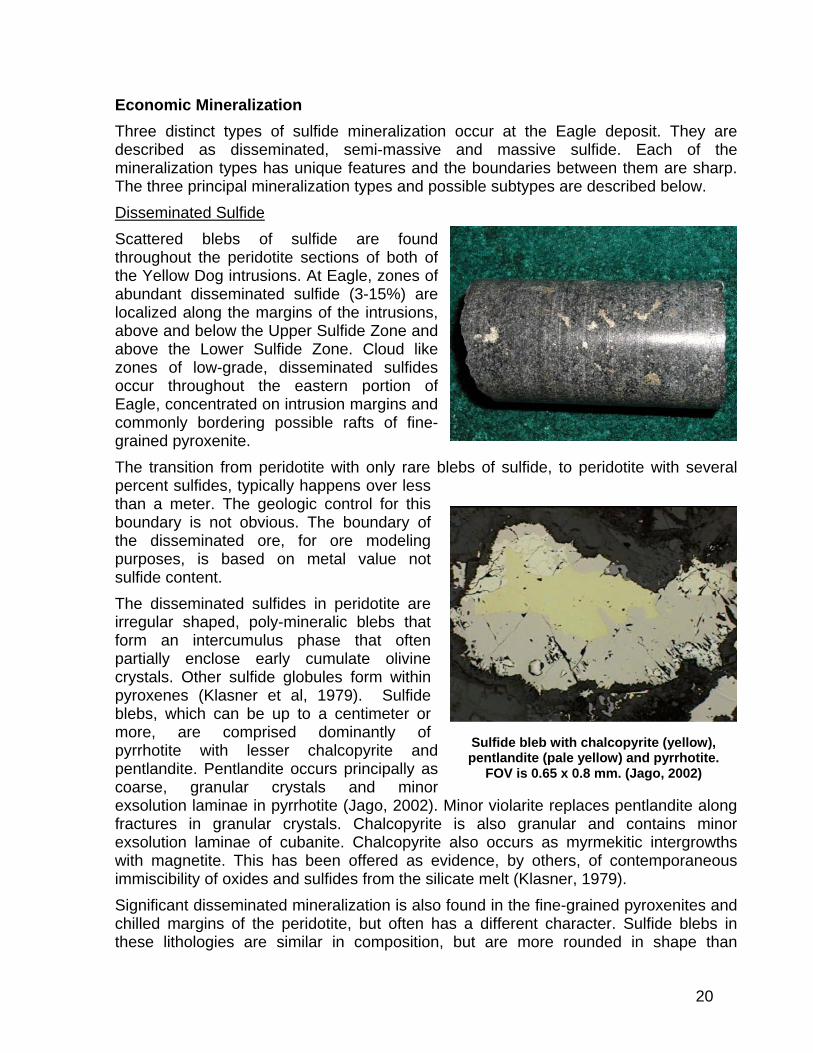
Economic Mineralization Three distinct types of sulfide mineralization occur at the Eagle deposit. They are described as disseminated, semi-massive and massive sulfide. Each of the mineralization types has unique features and the boundaries between them are sharp. The three principal mineralization types and possible subtypes are described below. Disseminated Sulfide Scattered blebs of sulfide are found throughout the peridotite sections of both of the Yellow Dog intrusions. At Eagle, zones of abundant disseminated sulfide (3-15%) are localized along the margins of the intrusions, above and below the Upper Sulfide Zone and above the Lower Sulfide Zone. Cloud like zones of low-grade, disseminated sulfides occur throughout the eastern portion of Eagle, concentrated on intrusion margins and commonly bordering possible rafts of fine-grained pyroxenite. The transition from peridotite with only rare blebs of sulfide, to peridotite with several percent sulfides, typically happens over less than a meter. The geologic control for this boundary is not obvious. The boundary of the disseminated ore, for ore modeling purposes, is based on metal value not sulfide content. The disseminated sulfides in peridotite are irregular shaped, poly-mineralic blebs that form an intercumulus phase that often partially enclose early cumulate olivine crystals. Other sulfide globules form within pyroxenes (Klasner et al, 1979). Sulfide blebs, which can be up to a centimeter or more, are comprised dominantly of pyrrhotite with lesser chalcopyrite and pentlandite. Pentlandite occurs principally as coarse, granular crystals and minor exsolution laminae in pyrrhotite (Jago, 2002). Minor violarite replaces pentlandite along fractures in granular crystals. Chalcopyrite is also granular and contains minor exsolution laminae of cubanite. Chalcopyrite also occurs as myrmekitic intergrowths with magnetite. This has been offered as evidence, by others, of contemporaneous immiscibility of oxides and sulfides from the silicate melt (Klasner, 1979).
Sulfide bleb with chalcopyrite (yellow), pentlandite (pale yellow) and pyrrhotite.
FOV is 0.65 x 0.8 mm. (Jago, 2002)
Significant disseminated mineralization is also found in the fine-grained pyroxenites and chilled margins of the peridotite, but often has a different character. Sulfide blebs in these lithologies are similar in composition, but are more rounded in shape than
20

disseminated blebs in coarse-grained peridotite. It has been suggested that some of these rounded sulfide blebs may be filling vesicles. Small veinlets of sulfide are also common in the pyroxenites. Similar sulfide veinlets are also found in the hornfelsed sediments. Semi-Massive Sulfide (SMSU) SMSU occurs in two separate zones of the Eagle Deposit. The SMSU is comprised of zones of 30-50% sulfide that forms a net textured matrix enclosing altered olivine, pyroxene crystals and rare feldspar. Limited thin section work, suggests that SMSU sulfides are similar to disseminated sulfides. The SMSU zones are bounded above and below by coarse-grained peridotite with disseminated sulfides. The SMSU and peripheral disseminated mineralization contain locally abundant intervals of fine-grained pyroxenite, some of which could be xenoliths or possibly thin dikes. Disseminated mineralization generally increases toward zones of SMSU. However, the transition between the disseminated mineralization and SMSU is typically abrupt with sulfide contents increasing from 5-10% to over 40% in less than a meter. Average metal content for the semi-massive sulfide is 2.11% Ni, 2.19% Cu, 0.06% Co, 0.27 g/T Au, 0.48 g/T Pt and 0.30 g/T Pd. Massive Sulfide (MSU) MSU forms a large, coherent, body that divides the western and eastern semi-massive zones. In the Lower Sulfide Zone, MSU is, in a number of locations, separated from SMSU by less mineralized pyroxenite and hornfelsed sediments. s of MSU of various compositions, up to several meters thick, also cut zones of SMSU and locally extend out into the metasediments. Rare xenoliths of hornfels, SMSU and peridotite have been noted in MSU veins. Phenocrysts of olivine, completely altered to serpentine, are found in trace amounts. Sulphide layering/banding in the massive sulfide is common, more so in the Lower Zone than the Upper Zone. The layering behaves much like a fluid or ductle fabric and has no apparent continuity from top to bottom in the sulphide bodies. Orientations determined from oriented core are highly
21 Chalcopyrite-rich MSU
Pyrrhotite-rich MSU

variable. The layering appears to be syn-depositional. MSU shows considerable variation in composition. Chalcopyrite content can vary from less than 10% to more than 50%. In most MSU, pyrrhotite is the dominant sulfide. Pyrrhotite occurs as coarse, anhedral grains with minor pentlandite and chalcopyrite exsolution lamellae (Jago, 2002). Limited microprobe analyses suggest that most of the pyrrhotite is an iron deficient (monoclinic) variety (Lane, 2002). This is supported by the typically high magnetic susceptibility of the MSU. Chalcopyrite and pentlandite primarily occur as coarse patches along pyrrhotite grain boundaries and in continuous networks of granoblastic textured stringers. When these stringers become abundant enough, they give the MSU a brecciated or “leopard skin” appearance. Cubanite occurs as exsolution lamella in chalcopyrite and violarite replaces pentlandite along fractures. Sphalerite is rarely observed. MSU contains up to 10% spinel. The very low TiO2 and chrome contents of the MSU suggest that the bulk of the spinel is simple magnetite. Magnetite occurs as discrete inclusions in pyrrhotite and chalcopyrite and in thin veinlets. Some of the magnetite likely formed from iron released during the conversion of high temperature, hexagonal pyrrhotite to low temperature, monoclinic pyrrhotite. Massive sulfides have an average metal content of 6.11% Ni, 4.15% Cu, 0.17% Co, 0.32 g/T Au, 1.14 g/T Pt and 0.77 g/T Pd.
Fe-oxide filled fracture with pentlandite and pentlandite/chalcopyrite exsolution lamellae in pyrrhotite. FOV is 0.65 x 0.8
mm. (Jago, 2002)
Pentlandite (light) and chalcopyrite (yellow) along grain boundaries in
pyrrhotite. FOV is 0.65 x 0.8 mm. (Jago, 2002)
22
23
24

25

26

27

28
29

30
31

32

Metal Distribution Limited petrography and QemSCAN work indicates most of the nickel is in pentlandite with a small portion in millerite group minerals and secondary violarite. The majority of pentlandite occurs in granular form with less than 1-2% as flame or exsolution lamellae. Copper is primarily in chalcopyrite with lesser secondary cubanite. Chalcopyrite occurs as anhedral inclusions in pyrrhotite and as coarse patches with granular pentlandite around pyrrhotite grains. Chalcopyrite also occurs as veins that locally cross cut SMSU and sedimentary units but these are volumetrically minor. The distribution of PGM, gold and cobalt is poorly understood but assay and metallurgical test correlations indicate the cobalt is with the pyrrhotite/pentlandite. PGM and gold appear to be related to late stage veining/intrusion and tend to be most abundant in areas with chalcopyrite enrichment.
References Bornhorst, T.J., and Rose, W.I., 1994. Self-guided geological field trip to the Keweenaw
Peninsula, Michigan. Institute On Lake Superior Geology, Proceedings 40th annual meeting, Houghton, Michigan. vol. 40 part 2. 185p.
Cannon, W.F., and Hinze, W.J., 1992. Speculations on the origin of the North American Midcontinent Rift. Tectonophysics, vol. 213, pp. 49-55.
Hinze, W.J., Allen, D.J., Braile, L.W., Mariano, J., 1997. The Midcontinent rift system: a major Proterozoic continental rift. In Middle Proterozoic to Cambrian Rifting. Eds. Ojakangas, R.W., Dickas, A.B, and Green, J.C., Geological Soc. of America Special Paper 312, pp. 7-35.
Jago, B.C., 2002, Petrographic description and X-ray diffraction characterization of serpentine minerals in 16 drill core samples. Unpub. private report for Kennecott Exploration by Lakefield Research, dated September 30, 2002, Project No. 8901-057/LIMS#MI5000-SEP02, 49 pp. + app.
Klasner, J.S., Snider, D.W., Cannon, W.F., and Slack, J.F., 1979. The Yellow Dog Peridotite and a possible buried igneous complex of lower Keweenawan age in the northern peninsula of Michigan. State of Michigan, Dept. of Natural Resources, Geological Survey Division; Report of Investigation 24, 31 pp.
Lane, G., 2002, Mineralogical determination of pentlandite and chalcopyrite distribution in three head samples and a bulk rougher tail. Unpub. Internal Kennecott report from Lakefield Research.
Miller, J.D., 1996. The latent magmatic stage of the Midcontinent rift: a period of magmatic underplating and melting of the lower crust (abst.); Institute on Lake Superior Geology, Proceedings 42nd annual meeting, Cable Wisconsin, vol. 42, part 1, p. 33
Miller, J.D., Green, J.C., Severson, M.J., Chandler, V.W., Hauck, S.A., Peterson, D.M., and Wahl, T.E., 2002. Geology and mineral potential of the Duluth Complex and related rocks of northeastern Minnesota: Minnesota Geological Survey Report of Investigations 58, 207 pp.
33

Morris, W.J., 1977. Geochemistry and origin of the Yellow Dog Plains peridotite, Marquette County, Northern Michigan. Unpub. MSc Thesis, Michigan State University. East Lansing, MI.
Nicholson, S.W., Shirley, S.B., Schultz, K.J., and Green, J.C., 1997. Rift-wide correlation of 1.1 Ga Midcontinent rift system basalts: implications for multiple mantle sources during rift development. Can. J. Earth Sci., vol. 34, pp. 504-520.
Schneider, D.A., Bickford, M.E., Cannon, W.F., Schultz, K.J., and Hamilton, M.A., 2002. Age of volcanic rocks and syndepositional iron formations, Marquette Range Supergroup: implications for the tectonic setting of Paleoproterozoic iron formations of the Lake Superior region. Can. J. Earth Sci., vol. 39, pp. 999-1012.
Sims, P.K., and Day, W.C., 1993. The Great Lakes Tectonic Zone-revisited. U.S. Geological Survey Bull. 1904-S, 11 p.
USGS, 1998. Northern Prairie Wildlife Research Center, Regional Landscape Ecosystems of Michigan, Minnesota, and Wisconsin; SUBSECTION IX.2. Michigamme Highland: http://www.npwrc.usgs.gov/resource/1998/rlandscp/sub9-2.htm
34

35