appendix d – fishery resources
TRANSCRIPT
D-1
APPENDIX D – FISHERY RESOURCES Introduction
This section presents the results of a reconnaissance level survey of Auburn Ravine for potential anadromous fish passage barriers or impediments and associated unscreened diversions. The purpose of this survey is to provide information which can be useful in developing an overall strategy for optimizing anadromous fish production in the Auburn Ravine system while preserving other watershed uses and values. Sites for evaluation were chosen by the Project Manager and visited on 22 and 23 March 2001. Most sites representing potential barriers/impediments for upstream- and downstream-migrating anadromous fish (fall chinook salmon and steelhead) were seasonal flashboard dams used for facilitating irrigation of surrounding agricultural land. A few dams are permanent; some dams are used for other purposes. Only unscreened diversions closely associated with potential upstream migration problem sites were evaluated for screening needs, and then only on a preliminary level. There are many additional unscreened diversions in the Auburn Ravine watershed and a significant number of these may well be deserving of evaluation for screening needs. Such evaluations were outside the scope of work for this reconnaissance level survey, however. Information was obtained at each site on the general setting and the configuration and approximate dimensions of dams or other obstructions. Each site was photographed. In most cases, the seasonal nature of operation of flashboard dams diminishes their threat to upstream anadromous fish migration. A few exceptions have been noted, and either operational or structural approaches to improving migration conditions have been developed. Permanent dams generally require some structural approaches to improve upstream migration conditions. Recommended alternatives are presented for these cases. Flashboard and permanent dams themselves generally do not present serious problems for downstream-migrating juvenile anadromous fishes (smolts). Associated unscreened diversions do present a threat to both rearing and downstream-migrating juveniles, however, especially in areas where water temperatures conducive to rearing encourage fish presence throughout the irrigation season. Although this was not intended to be a comprehensive survey of irrigation diversions, those directly associated with and proximal to dams were assessed, especially where the relationship of diversions to the dams themselves tended to exacerbate entrainment problems or potentially present false migration cues. Potential solutions to these problems are presented.

Auburn Ravine/Coon Creek Ecosystem Restoration Plan Appendix D: Anadromous Fish Passage and CRMP Review Draft Unscreened Diversion Survey June 28, 2002
D-2
Nevada Irrigation District Gaging Station
Location: The site is located about 1/4 mi downstream of SR 65 in the City of Lincoln. General Description: This structure is a full channel width concrete section installed in association with a recording stream gage owned and maintained by Nevada Irrigation District. The section forms a broad flume with vertical sides, an upward-sloping approach, and a level crest with an ogee shape descending to a horizontal apron which spills onto large boulders to dissipate energy and prevent undermining. The flume and crest section is 25 ft wide, with flaring upstream and downstream side walls. The existing structure is shown in Figure 1.
Figure 1. Nevada Irrigation District stream gage, Auburn Ravine (near Lincoln).
The configuration of this concrete section makes it an “ideal” fish migration barrier except at very high flows. Note lack of plunge pool and unfavorable “receiving water” conditions

Auburn Ravine/Coon Creek Ecosystem Restoration Plan Appendix D: Anadromous Fish Passage and CRMP Review Draft Unscreened Diversion Survey June 28, 2002
D-3
Assessment: This structure is a significant impediment to upstream anadromous fish migration at all but extremely high flows, when the structure would become drowned out. Good passage requires either swim-up conditions (preferred) or the combination of a plunge pool with a standing wave, height of the obstruction less than the leaping ability of the fish, and quiescent “receiving water” conditions at the top of the obstruction into which the fish can leap. None of these conditions is met at this site under most stream flow conditions (when the structure is drowned out, swim-up conditions are likely present). Priority for Attention: High. Alternative Approaches:
Formal Fishway – This alternative would involve construction of a formal engineered fishway around the site. Recommended configuration for this alternative is a vertical slot and orifice fishway of standard design. Location should be on the right bank if maintenance access across adjacent private land can be obtained (to reduce poaching and vandalism risks) or on the right bank if such access can not be obtained. If the structure is constructed on the left bank, which would be easily accessible to vandals and poachers (high risk at this site), the fishway should be completely covered with a heavy-duty locked grating. Maintenance during the migration season should be at least weekly, to keep the fishway clear of obstructing debris. If this alternative is implemented, the entire complex would have to be re-rated to calibrate the stream gage. Some minor loss of precision may result due to increased hydraulic complexity, especially if debris is allowed to accumulate in the fishway.
Pool-and-Chute Replacement – This alternative would involve the replacement of the existing concrete section with an engineered “Pool-and-Chute” fishway spanning the entire channel. These structures are essentially a series of shallow-angle “V” weirs with a central notch to the structure floor about 1 ft in width. A design concept diagram showing proportions of various elements is given in Attachment A. Although relatively new, this structure is well-tested, and provides good passage conditions for both adult and juvenile anadromous fishes under a very wide range of flow. The formal design of these structures is conducive to the development of rather precise stage-discharge relationships, making this alternative a suitable substitute for the existing section at this stream gaging site. Naturally, the gage would have to be re-rated, but the resulting precision would likely be as good or nearly as good as the existing flume section, and superior to the combination of the existing structure and a circumventing formal fishway.
Backwater Existing Section – This alternative would involve placing a series of low, very shallow angle “V” weirs across the channel downstream of the existing concrete section to backwater the existing section to the point where swim-over conditions were achieved for most stream discharges typical of the anadromous fish upstream migration season. Implementing this approach would seriously compromise the precision of the gaging station. More importantly, this approach would significantly reduce the

Auburn Ravine/Coon Creek Ecosystem Restoration Plan Appendix D: Anadromous Fish Passage and CRMP Review Draft Unscreened Diversion Survey June 28, 2002
D-4
conveyance capacity of the channel immediately downstream of the gage, resulting in increased flood risk. Although technically feasible with accompanying flood protection measures, this approach is probably not practical.
Recommendation: Implement the “Pool-and-Chute Replacement” alternative on a high priority basis.

Auburn Ravine/Coon Creek Ecosystem Restoration Plan Appendix D: Anadromous Fish Passage and CRMP Review Draft Unscreened Diversion Survey June 28, 2002
D-5
Coppin Dam
Location: This site is located near the downstream end of the “engineered” portions of Auburn Ravine. General Description: Coppin Dam is located on the Cross-Canal very near the terminus of Auburn Ravine where it enters the Cross-Canal. The trapezoidal abutments for this seasonal flashboard dam are 85 ft apart and are connected by a concrete sill on the channel invert. South Sutter Water District diverts water from the Cross Canal immediately opposite the terminus of the Auburn Ravine channel. During the summer irrigation season, this dams stops all or nearly all flow coming down Auburn Ravine. Flash boards are generally installed on 01 April; water is diverted by South Sutter Water District from 15 April to 15 October in most years. The diversion is not screened. The right abutment of Coppin Dam in the flashboards-out condition and the Cross-Canal channel are shown in Figure 2. Figure 2. Coppin Dam site on the Cross-Canal near the terminus of Auburn Ravine
(behind camera) in “flashboards-out” condition. Note the dark right abutment on the far side of the channel

Auburn Ravine/Coon Creek Ecosystem Restoration Plan Appendix D: Anadromous Fish Passage and CRMP Review Draft Unscreened Diversion Survey June 28, 2002
D-6
Assessment: The seasonal operation of this dam means that it is not a significant impediment to upstream-migrating anadromous fish in most if not all years. This facility is on the valley floor in an area where water temperatures are not conducive to year-round rearing of anadromous fish. In addition, most active downstream migration of smolts in most years is outside the irrigation diversion season. For these reasons, screening the South Sutter Water District diversion should be considered a low priority action, if it is justified at all. Priority for Attention: Low. Alternative Approaches: None developed. Recommendation: Do nothing.
Auburn Ravine/Coon Creek Ecosystem Restoration Plan Appendix D: Anadromous Fish Passage and CRMP Review Draft Unscreened Diversion Survey June 28, 2002
D-7
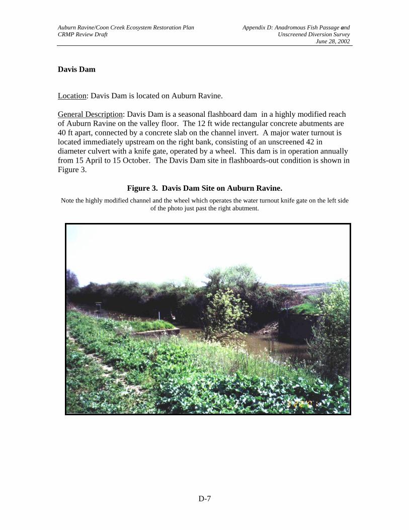
Davis Dam
Location: Davis Dam is located on Auburn Ravine. General Description: Davis Dam is a seasonal flashboard dam in a highly modified reach of Auburn Ravine on the valley floor. The 12 ft wide rectangular concrete abutments are 40 ft apart, connected by a concrete slab on the channel invert. A major water turnout is located immediately upstream on the right bank, consisting of an unscreened 42 in diameter culvert with a knife gate, operated by a wheel. This dam is in operation annually from 15 April to 15 October. The Davis Dam site in flashboards-out condition is shown in Figure 3.
Figure 3. Davis Dam Site on Auburn Ravine. Note the highly modified channel and the wheel which operates the water turnout knife gate on the left side
of the photo just past the right abutment.

Auburn Ravine/Coon Creek Ecosystem Restoration Plan Appendix D: Anadromous Fish Passage and CRMP Review Draft Unscreened Diversion Survey June 28, 2002
D-8
Assessment: The seasonal operation of this dam means that it is not a significant impediment to upstream-migrating anadromous fish in most if not all years. This facility is on the valley floor in an area where water temperatures are not conducive to year-round rearing of anadromous fish. In addition, most active downstream migration of smolts in most years is outside the irrigation diversion season. For these reasons, screening the turnout adjacent to Davis Dam, and other diversions (pumped or gravity) in this area should be considered a low priority action, if it is justified at all. Priority for Attention: Low. Alternative Approaches: None developed. Recommendation: Do nothing.

Auburn Ravine/Coon Creek Ecosystem Restoration Plan Appendix D: Anadromous Fish Passage and CRMP Review Draft Unscreened Diversion Survey June 28, 2002
D-9
Tom Glenn Dam
Location: Tom Glenn Dam is located on Auburn Ravine. General Description: Tom Glenn Dam is a seasonal flashboard dam on a highly modified reach of Auburn Ravine on the valley floor. The trapezoidal abutments are 40 ft apart, connected by a rough, 8 ft broad ogee-shaped concrete sill with a downstream transition into a short “flip-lip”. The “flip-lip” is broken away on the right side, but the structure does not appear to be at risk of undermining. Tom Glenn Dam is operated annually from 14 April through 15 October. The site is shown in Figure 4.
Figure 4. Tom Glenn Dam on Auburn Ravine. Note the elevated sill connecting the abutments and the difference in hydraulics near the right abutment (left
side of photo), which facilitates fish passage at this site.

Auburn Ravine/Coon Creek Ecosystem Restoration Plan Appendix D: Anadromous Fish Passage and CRMP Review Draft Unscreened Diversion Survey June 28, 2002
D-10
Assessment: The seasonal operation of this facility means that it is not a significant impediment to upstream-migrating anadromous fish in most if not all years. In spite of the elevated sill, in its flashboards-out condition, this structure does not present a significant impediment to upstream anadromous fish migration, partially because of the broken condition of the “flip-lip”near the right abutment; if this were repaired, this structure would become a minor impediment at low flows, but at higher flows, typical of most upstream migration periods, a swim-over condition would be present. This facility is on the valley floor in an area where water temperatures are not conducive to year-round rearing of anadromous fish. In addition, most active downstream migration of smolts in most years is outside the irrigation diversion season. Priority for Attention: Low. Alternative Approaches: None developed. Recommendation: Do nothing.

Auburn Ravine/Coon Creek Ecosystem Restoration Plan Appendix D: Anadromous Fish Passage and CRMP Review Draft Unscreened Diversion Survey June 28, 2002
D-11
Aitken Ranch Dam
Location: Turkey Farm Dam is located on Auburn Ravine. General Description: Aitken Ranch Dam is a seasonal flashboard dam on a modified reach of Auburn Ravine on the valley floor. The trapezoidal abutments are 26 ft apart and are connected with a concrete sill even with the channel invert. The abutments support a flat car bridge. Aitken Ranch Dam is operated annually from 15 April through 15 October. The site is shown in flashboards-out condition in Figure 5.
Figure 5. Aitken Ranch Dam on Auburn Ravine, flashboards-out condition. Note the flat car bridge. Flashboards are placed on the upstream side of the bridge on a concrete sill

Auburn Ravine/Coon Creek Ecosystem Restoration Plan Appendix D: Anadromous Fish Passage and CRMP Review Draft Unscreened Diversion Survey June 28, 2002
D-12
Assessment: The seasonal operation of Aitken Ranch Dam means that it is not a significant impediment to upstream-migrating anadromous fishes in most years. This modified (channelized) reach of Auburn Ravine has physical habitat features which could support rearing juvenile anadromous fish, and temperatures in this part of the valley floor during at least part of the irrigation season would also support populations of these fish in some years. Although no diversion is located in the immediate vicinity of this structure, those within its influence upstream are unscreened, and may be candidates for screening. Priority for Attention: Low for dam; medium for unscreened diversions in this reach. Alternative Approaches: None for upstream passage. Unscreened diversions under the influence of Aitken Ranch Dam were not directly observed, but simple rotating drum screens meeting anadromous fish screening criteria (3/32 in clear space screens sized to achieve < 0.4 fps approach velocity with internal porosity control) would likely be appropriate for pumped diversions. Gravity diversions, if any are present in this area, should be assessed for screening feasibility; vertical flat plate screens meeting the above criteria and with automatic wiper systems for cleaning would likely be the best approach if screens are deemed necessary. Recommendation: Do nothing for upstream passage. Assess unscreened diversions and seasonal stream temperatures, perhaps in conjunction with fish surveys to establish juvenile anadromous fish presence during the irrigation season, to determine if screens are needed.

Auburn Ravine/Coon Creek Ecosystem Restoration Plan Appendix D: Anadromous Fish Passage and CRMP Review Draft Unscreened Diversion Survey June 28, 2002
D-13
Moore Dam
Location: Moore Dam is located on Auburn Ravine General Description: Moore Dam is a seasonal flashboard dam on a somewhat modified reach of Auburn Ravine on the valley floor. A relatively wide expanse of semi-natural channel and riparian corridor extends upstream of the dam structure. The rectangular abutments are 56 ft apart and are joined by a concrete slab on the channel invert. Moore Dam is operated annually from 15 April to 15 October. A major water turnout is located in an alcove off the main Auburn Ravine channel about 70 ft to the right of the right abutment, and is controlled by twin knife gates on two 36 in diameter culverts passing under an access road to a canal. Figure 6 shows Moore Dam abutments in the flashboards-out condition. Figure 7 shows the semi-natural channel and riparian area upstream of the dam structure.
Figure 6. Moore Dam abutments in flashboards-out condition. The gates and culverts in the alcove controlling water delivery to the canal are about 70 ft behind the camera

Auburn Ravine/Coon Creek Ecosystem Restoration Plan Appendix D: Anadromous Fish Passage and CRMP Review Draft Unscreened Diversion Survey June 28, 2002
D-14
Figure 7. Semi-natural stream channel and riparian area immediately upstream of Moore Dam.
The entry to the alcove leading diverted water to the canal is on the left of the photo.
Auburn Ravine/Coon Creek Ecosystem Restoration Plan Appendix D: Anadromous Fish Passage and CRMP Review Draft Unscreened Diversion Survey June 28, 2002
D-15
Assessment: The seasonal operation of Moore Dam means that it is not a significant impediment to upstream-migrating anadromous fishes in most years. This reach of Auburn Ravine has physical habitat features which could support rearing juvenile anadromous fish, and temperatures in this part of the valley floor during at least part of the irrigation season would also support populations of these fish in some years. The diversion located in the immediate vicinity of this structure is unscreened, and may be a candidate for screening, along with others in this general area. The appropriateness for screening should depend on future investigations and temperature data review to see if they indicate that there is a significant risk to rearing anadromous fish populations in the general vicinity during the irrigation season. Priority: Low for passage. Medium for unscreened diversions in this reach, pending results of temperature data review. Alternative Approaches: If screening is deemed appropriate, simple rotating drum screens meeting anadromous fish screening criteria (3/32 in clear space screens sized to achieve < 0.5 fps approach velocity with internal porosity control) would likely be appropriate for pumped diversions. Gravity diversions, such as the turnout in direct associated with Moore Dam, should probably be fitted with vertical flat plate screens meeting the above criteria and with automatic wiper systems for cleaning would likely be the best approach. In this case, the screen should be placed diagonally across the alcove with the downstream end on the left (looking in the direction of water flow. At that point, a 6 in diameter bypass pipe should be buried under the ground separating the right dam abutment from the alcove, with the bypass terminus in the scour pool below the dam. Recommendation: Do nothing for upstream passage. Assess unscreened diversions and seasonal stream temperatures, perhaps in conjunction with fish surveys to establish juvenile anadromous fish presence during the irrigation season, to determine if screens are needed.

Auburn Ravine/Coon Creek Ecosystem Restoration Plan Appendix D: Anadromous Fish Passage and CRMP Review Draft Unscreened Diversion Survey June 28, 2002
D-16
Nelson Lane Dam
Location: Nelson Lane Dam is located on Auburn Ravine.... General Description: Nelson Lane Dam is a seasonal flashboard dam on a modified reach of Auburn Ravine in the lower elevation foothills above the valley floor. The trapezoidal abutments are 60 ft apart and are joined by a declining concrete slab on the channel invert. Nelson Lane Dam is operated annually from 15 April to 15 October in most years. A major pumped water diversion is located at the end of a long alcove off the main Auburn Ravine channel about 120 ft to the right of the right abutment. Four operating unscreened pumps are present with 8-10 inch diameter pipes extending into the alcove pool. Figure 8 shows Nelson Lane Dam abutments in the flashboards-out condition. Figure 9 shows the alcove channel looking from the point of bifurcation from the main Auburn Ravine channel. Figure 10 shows the pumps.
Figure 8. Nelson Lane Dam abutments in the flashboards-out condition. Note the declining slab angle
(Photo missing)

Auburn Ravine/Coon Creek Ecosystem Restoration Plan Appendix D: Anadromous Fish Passage and CRMP Review Draft Unscreened Diversion Survey June 28, 2002
D-17
Figure 9. Alcove channel leading from the Auburn Ravine main channel (behind the camera) to the unscreened irrigation diversion pumps

Auburn Ravine/Coon Creek Ecosystem Restoration Plan Appendix D: Anadromous Fish Passage and CRMP Review Draft Unscreened Diversion Survey June 28, 2002
D-18
Figure 10. Nelson Lane Dam diversion pumps at terminus of alcove.

Auburn Ravine/Coon Creek Ecosystem Restoration Plan Appendix D: Anadromous Fish Passage and CRMP Review Draft Unscreened Diversion Survey June 28, 2002
D-19
Assessment: The seasonal operation of Nelson Lane Dam means that it is not a significant impediment to upstream-migrating anadromous fishes except at lower stream flows which may characterize portions of the migration period in some years. The tipped slab between the abutments creates a high-velocity area (super-critical flow) at lower discharge. This forces the water to become significantly more shallow at this point and could create a significant impediment if lower stream flows persist. The water temperatures in this part of the Auburn Ravine watershed could support populations of rearing salmonid juveniles for at least portions of the irrigation season, making these fish vulnerable to entrainment by unscreened pumps associated with this facility. The location of the pumps at the end of an alcove with significant channel length means that if fish are actively migrating, they may enter a dead-end channel with downstream cues, leading to potentially significant migration delay. Priority for Attention: For upstream passage, medium. For pump screening, medium, pending review of temperature data and risk analysis. Alternative Approaches:
Upstream Passage – Pending discharge frequency data review and need analysis, rock-bolt 10 x 10 in treated timbers across the tipped concrete apron immediately downstream or immediately upstream of the flashboard channel supports, leaving a 1.5 - 2 ft wide gap in the middle of the span. This will form an attraction jet and concentrate flow into a deeper pattern, enabling passage at lower discharges. Clear out some of the rock debris in the pool immediately downstream of the concrete sill, as necessary.
Pump Screens – Pending water temperature data review and risk assessment, install vertical, rotating drum screens on each of the four pumps. Install a treated lumber wing-wall across the alcove near the pumps, leaving a gap of 3-4 ft between the end of the wall and the right alcove bank. This will force water flowing toward the pumps to approach from the right side of the pump line and pass along the line toward the left alcove bank. Install a 6 in diameter bypass pipe leading from the left alcove bank through the ground separating the alcove from the main Auburn Ravine channel, terminating below the sloping concrete sill between the dam abutments. Excavate a pool at the end of the pipe and submerge the outlet to kill the jet. This arrangement will create a sweeping flow along the row of pumps toward the bypass pipe and provide a downstream migration cue guiding fish to the bypass. It will only be necessary to operate the bypass during the downstream migration period.
Recommendation: Perform need (upstream passage) and risk (pump screening) analyses. If improvements are indicated by the analyses, implement the alternatives described above.

Auburn Ravine/Coon Creek Ecosystem Restoration Plan Appendix D: Anadromous Fish Passage and CRMP Review Draft Unscreened Diversion Survey June 28, 2002
D-20
Lincoln Ranch Duck Club Dam
Location: Lincoln Ranch Duck Club Dam is located on Auburn Ravine. General Description: Lincoln Ranch Duck Club Dam is a seasonal flashboard dam on a highly modified reach of Auburn Ravine on the valley floor. The rectangular abutments are 27 ft apart and connected by a concrete sill. The abutments are spanned by a flat car bridge. A gravity water turnout is located on the right bank of Auburn Ravine immediately upstream of the right dam abutment. A pumped diversion fitted with a trash screen is set into the left bank of Auburn Ravine immediately upstream of the left dam abutment. Lincoln Ranch Duck Club Dam is unusual in that it is operated from ------- to ---------, well into the upstream migration season for adult salmonids. The Lincoln Ranch Duck Club Dam abutments and bridge in the flashboards-out condition are shown in Figure 11.
Figure 11. Lincoln Ranch Duck Club Dam on Auburn Ravine (looking downstream).
Note the partially-obscured pumped diversion on the left bank behind a short wing wall to divert debris and the partially-obscured control wheel for the gravity water turnout on the right bank

Auburn Ravine/Coon Creek Ecosystem Restoration Plan Appendix D: Anadromous Fish Passage and CRMP Review Draft Unscreened Diversion Survey June 28, 2002
D-21
Assessment: The unusual seasonal operation of this facility makes it a special case when assessing potential effects on upstream migration of anadromous fishes. The water surface elevation difference with flashboards in can be as much as 6 ft, depending on total stream flow. During higher flows, steelhead and chinook can obviously negotiate this structure, since these species are known to reproduce at higher elevations in the watershed. However, this facility undoubtedly forms a significant impediment to upstream-migrating salmon and steelhead for a significant part of the migration season. For this reason, passage improvements are desirable. The extended use of the associated pumped water diversion also poses some risk of entrainment of juvenile salmonids, especially small fry during initial dispersal following emergence from incubation. Although anadromous fish spawning is not thought to occur in the immediate vicinity of Lincoln Ranch Duck Club Dam, initial dispersal often transports fry considerable distances downstream. For this reason, screening this diversion, at least on a seasonal basis is considered desirable. A more complete evaluation, possibly incorporating sampling for fry presence during periods of operation, should be conducted prior to allocating significant expenditures for fish screens at this site, however. Priority for Attention: For upstream passage, medium to high, depending on water conditions during the upstream migration season. For diversion screening, low to medium, depending on a more thorough evaluation of seasonal entrainment risk. Alternative Approaches: Upstream Fish Passage – This site is not well suited for a formal fishway bypassing the flashboard structure. However, passage could be accomplished in two other ways: 1. Pool excavation; pump extension This approach would involve excavating a pool
or sump immediately upstream of the existing flashboard dam structure at the location of the diversion pump, and extending the pump tube into the sump. This would allow continued operation of the flashboards in the present manner, posing no change in upstream flood risk. The sump would have a tendency to accumulate fine sediment, however, potentially interfering with pump operation or increasing mechanical wear and maintenance costs. This might be successfully offset by installation of “vortex weirs” at the entrance to the sump, which are designed to capture and concentrate bed load and “saltating” fine sediments and send them downstream. Some increase in energy costs would be incurred due to increased lift requirements.
2. Pool and chute fishway This approach would involve replacement of the existing
flashboard dam structure with a formal “pool-and-chute” fishway section across the entire Auburn Ravine channel. This structure would permanently raise the invert elevation of the Auburn Ravine channel at this point, increasing the risk of flooding upstream in the event of very high discharge (no flashboard adjustment would be possible). The pool behind the structure would have a tendency to fill with fine sediment, potentially interfering with pump operation or increasing mechanical
Auburn Ravine/Coon Creek Ecosystem Restoration Plan Appendix D: Anadromous Fish Passage and CRMP Review Draft Unscreened Diversion Survey June 28, 2002
D-22
wear and maintenance costs. No increased energy cost would be incurred, however.
Screening – Pending an entrainment risk analysis demonstrating need, the diversion pump could be fitted with a vertical drum screen meeting appropriate fish screen criteria (3/32 in clear space screens sized to achieve 0.4 fps approach velocity with internal porosity control). A hydraulic analysis of the expected flow net in the immediate vicinity of the screen should be performed to determine whether a simple rotating screen or a back-flush or wiper system would be most appropriate for screen cleaning. Recommendation: For upstream-migrating anadromous fish passage, implement the first alternative described above. Analyze the appropriateness of use of “vortex weirs” and develop a maintenance schedule accordingly. Perform an entrainment risk analysis, and install a drum screen if indicated by the analysis.

Auburn Ravine/Coon Creek Ecosystem Restoration Plan Appendix D: Anadromous Fish Passage and CRMP Review Draft Unscreened Diversion Survey June 28, 2002
D-23
Hemphill Dam
Location: Hemphill Dam is located on Auburn Ravine. General Description: Hemphill Dam is a relatively large seasonal flashboard dam on a slightly modified reach of Auburn Ravine in the low elevation foothills of the watershed near the Turkey Creek Golf Course. The trapezoidal dam abutments are about 8 ft high and 64 ft apart, connected by an elevated horizontal concrete sill. A relatively smooth gunnited rubble apron slopes downstream from the concrete sill to a plunge pool filled with large angular boulders for energy dissipation. Banks upstream and downstream of the abutments are about 75 ft apart and are protected by large gunnited rip-rap. This bank protection is more prominent on the right bank, extending about 75 ft upstream and 60 ft downstream of the abutments. An unscreened gravity diversion with a knife gate control and a sloping trash rack is located on the left bank about 50 ft upstream of the left dam abutment. The elevation of the sill between the dam abutments is about 6 ft above the natural invert of the stream channel, and the relatively smooth gunnited rubble apron produces very shallow super-critical sheeting flow at low to moderate stream flows. Hemphill Dam in the flashboards-out condition is shown in Figure 12.
Figure 12. Hemphill Dam on Auburn Ravine near Turkey Creek Golf Course. Note the protected banks and the gunnited rubble apron producing shallow super-critical flow

Auburn Ravine/Coon Creek Ecosystem Restoration Plan Appendix D: Anadromous Fish Passage and CRMP Review Draft Unscreened Diversion Survey June 28, 2002
D-24
Assessment: At most stream flows, including those representative of the adult anadromous fish migration season, the configuration of the sill and apron at Hemphill Dam produces super-critical flow for a distance of at least 30 ft. This results in a velocity barrier condition for upstream-migrating anadromous fish at all but very high stream flows when the entire structure becomes drowned out and swim-over conditions would be present. The relatively greater bed roughness on the apron near the right abutment (Far side in Figure 12) may ameliorate this condition somewhat, reducing passage difficulties at moderately high stream flows, but this structure would still probably be considered an impediment, potentially resulting in migration delays or “encouraging” fish to spawn further downstream than would otherwise be the case. It should be noted that there is some very good spawning habitat for chinook salmon, and possibly steelhead, in the reach downstream of Hemphill Dam. The gravity diversion is unscreened, and would present a threat of entrainment of juvenile salmonids present during periods of operation. Since this facility is in the low elevation foothills of the Auburn Ravine foothills, water temperatures would likely support rearing populations of juvenile salmonids during part of the irrigation season. In addition, as noted above, relatively good spawning habitat is present in the general vicinity of Hemphill Dam, suggesting that populations of rearing anadromous fish may well be present during portions of the irrigation season in at least some years. This suggests that screening the diversion in association with Hemphill Dam, and others in the general vicinity, is appropriate. Priority for Attention: For upstream anadromous fish passage, high. For diversion screening, medium to high, depending on results of a risk assessment, perhaps including sampling for rearing anadromous fish presence during portions of the irrigation season. Alternative Approaches: Upstream Fish Passage – Upstream fish passage at this site could be provided in two ways: 1. Pool and chute fishway This site is very conducive to installation of a pool and
chute fishway spanning the entire Auburn Ravine channel. This structure would replace the existing gunnited rubble apron immediately downstream of the horizontal concrete sill connecting the dam abutments. Little or no change in channel conveyance capacity is anticipated for this approach. If detailed hydraulic analysis indicates that channel conveyance capacity would be reduced, it is expected that this change would be minor and could be mitigated by a slight increase in channel width at the dam site, which could be accomplished by moving one of the abutments back an appropriate distance. This approach would assure good passage conditions at all migration season discharges when the dam is in its flashboards-out condition. Advantages of this approach include essentially maintenance-free operation, good to excellent passage conditions under all or nearly all flow conditions, no migration delay and limited or no poaching/vandalism opportunities. Disadvantages include potential for slight decrease channel conveyance capacity and possibly relative cost.

Auburn Ravine/Coon Creek Ecosystem Restoration Plan Appendix D: Anadromous Fish Passage and CRMP Review Draft Unscreened Diversion Survey June 28, 2002
D-25
2. Backwater the apron and add roughness This approach is similar to the pool and
chute fishway described in the first alternative, above, but less formal in execution, with a less reliable outcome. Backwatering of the Hemphill Dam apron would involve construction of a series (probably three) of low, shallow “V” weirs, with each consecutive “V” 12-18 in higher in elevation than the one downstream. The furthest upstream “V” should be located near the toe of the existing apron. Roughness elements (“dentates”) should be added to the apron near the crest to break up sheeting flow and provide hydraulic complexity. Advantages of this approach include good passage conditions over a wide range of stream flows while the dam is in the flashboards-out configuration, essentially maintenance-free operation, no significant migration delay, limited or no poaching/vandalism opportunities and potential cost savings over the first alternative. Disadvantages include a larger construction footprint than the first alternative and a slightly increased potential for reducing overall channel conveyance capacity at the crest of the apron in the flashboards-out configuration. This last disadvantage could be overcome by moving one of the abutments back an appropriate distance, if deemed necessary.
3. Formal slotted fishway This approach would involve design and construction of a
formal fishway around Hemphill Dam. Adequate space exists on either side of the dam, but each side has advantages and disadvantages. Advantages of the right side include lower poaching and vandalism opportunities. Disadvantages of the right side include more difficult construction and maintenance access, probably involving right-of-way acquisition. Advantages of the left side include easy construction and maintenance access and probably little or no difficulty obtaining a right of way or easement. Disadvantages include increased poaching and vandalism risk and an alignment conflict with the existing diversion canal, requiring an inverted siphon in the canal under the fishway alignment. Other advantages of this general approach include potentially lower cost and no risk of reduction of channel conveyance capacity. Other disadvantages of this general approach include a narrower range of ideal operating conditions relative to Auburn Ravine stream flow, increased overall risk of vandalism and poaching, and regular maintenance requirements.
Screening – If screening the gravity diversion is warranted by an entrainment risk analysis, the most appropriate approach for this site is a vertical flat plate screen meeting appropriate anadromous fish screening criteria (3/32 in clear space screen; 0.4 fps approach velocity) constructed flush with the left bank in the approximate location of the existing diversion. The screen should have a mechanical wiper for cleaning which could be driven mechanically or by hydraulic motor off a paddle wheel in the diversion canal. If water depth is insufficient to achieve necessary screen area without excessive length, the screen panel could be sloped, but the slope should not be flatter than 45Ε off the vertical with a mechanical wiper cleaning device. If the screen is flatter than 45Ε, an air burst cleaning system should be considered, but this would require pulling power to the site and installing

Auburn Ravine/Coon Creek Ecosystem Restoration Plan Appendix D: Anadromous Fish Passage and CRMP Review Draft Unscreened Diversion Survey June 28, 2002
D-26
a compressor and pressure accumulator tank, along with appropriate controls and sensors. The mechanical wiper system is by far the simpler system, and would require less maintenance and a lower capital outlay. Recommendations: For adult fish passage, implement the first alternative described above (pool-and-chute fishway) on a high-priority basis, pending results of a uniform engineering cost estimate (if such a cost estimate favors the backwatering/roughness approach, implement that alternative instead). For screening, assuming an entrainment risk assessment indicates the need for screens, implement the described approach.

Auburn Ravine/Coon Creek Ecosystem Restoration Plan Appendix D: Anadromous Fish Passage and CRMP Review Draft Unscreened Diversion Survey June 28, 2002
D-27
Ophir Tunnel Cataract
Location: The cataract at Ophir Tunnel is located just upstream of Lozanos Road on Auburn Ravine General Description: A steep cataract is located on Auburn Ravine immediately adjacent to the outlet of Ophir Tunnel. The flows over the cataract exhibit much hydraulic complexity passing over a very rough bed, except at the lower end, where the rock is smoother. The cataract adjacent to Ophir Tunnel is shown in Figure 13.
Figure 13. Cataract on Auburn Ravine adjacent to Ophir Tunnel. Note the extremely rough bed and hydraulic complexity over most of the distance.

Auburn Ravine/Coon Creek Ecosystem Restoration Plan Appendix D: Anadromous Fish Passage and CRMP Review Draft Unscreened Diversion Survey June 28, 2002
D-28
Assessment: This cataract is clearly an impediment to steelhead at lower stream flows, but is probably passable to some fish at high stream flows. Because of the smoother bed and reduced hydraulic complexity at the lower end, this part of the cataract is the more difficult part for fish to negotiate. Some improvement in passage conditions over a wider range of flows could be achieved by backwatering the lower end of this cataract, giving fish an opportunity to reach more complex portions of this area with less effort and fewer trials. Priority for Attention: Medium. Alternative Approaches: The most cost effective approach to improving steelhead passage conditions at this impediment is to backwater the lower end of the cataract with a series of two or three low, shallow “V” weirs installed across the plunge pool immediately downstream. Crest elevations of these weirs should be 12 to 18 in apart; the weirs themselves should be about 10 ft apart, with the most upstream in the series about 10-12 ft downstream of the existing toe of the cataract. Recommendation: Implement the approach described above on a medium priority basis.

Auburn Ravine/Coon Creek Ecosystem Restoration Plan Appendix D: Anadromous Fish Passage and CRMP Review Draft Unscreened Diversion Survey June 28, 2002
D-29
Nevada Irrigation District Auburn Ravine 1 Dam
Location: Nevada Irrigation District (NID) 1 Dam is located on Auburn Ravine off Chili Hill Road General Description: NID 1 Dam is a gravity arch dam in the middle of the Auburn Ravine watershed. The level crest of the dam is about 8 ft above the tailwater during normal stream flows. The pool behind the dam feeds an unscreened gravity diversion to the NID ditch on the north side of Auburn Ravine. The ditch is lined with gunnite for most of its length in this area. A sluice gate for flushing sediment which accumulates behind the dam is located on the north side of the crest near the entry to the ditch. Channel depth below the dam is deeper on the south side, with boulders and bedrock protruding from the tailwater on the north side during normal stream flows. NID 1 Dam and the upper end of the NID ditch are shown in Figure 14.
Figure 14. NID 1 Dam and upper end of NID Ditch. Note the level dam crest and the deeper stream channel on the left (south) side of the channel (right side of
the photo).

Auburn Ravine/Coon Creek Ecosystem Restoration Plan Appendix D: Anadromous Fish Passage and CRMP Review Draft Unscreened Diversion Survey June 28, 2002
D-30
Assessment: This dam is clearly a migration barrier to upstream-migrating salmon and steelhead except at high stream flows approaching drown-out, when it would become an impediment. The level crest distributes overflow evenly. Greater channel depth on the south side of the channel opposite the ditch would tend to encourage fish to congregate in that area under most flow conditions, making an accessible solution more difficult. A formal fishway on the south side of the dam is probably not feasible, due to severe access difficulties. Protruding bedrock formations on the north side of the channel below the dam add difficulty to a passage solution in that area. Presence and operation of the sediment sluice next to the ditch add complexity to a passage solution on the north side of the dam. Much of the best steelhead habitat in the Auburn Ravine watershed is located upstream of this facility, increasing the importance of a passage solution here. This part of the Auburn Ravine watershed contains excellent anadromous fish rearing habitat and water quality. Since juvenile anadromous fish are present in this area on a year-round basis, screening the approximately 100 cfs diversion is important. Priority for Attention: For upstream passage, high. For diversion screening, high. Alternative Approaches: Any passage solution on the south side of NID 1 Dam is plagued with virtually impossible access problems, effectively eliminating this area from consideration. Stepping up the stream channel below the dam would severely reduce channel conveyance capacity immediately below the dam, threatening the ditch and control works during high stream flows, effectively eliminating this approach as a viable solution candidate. The only remaining approach is to construct a formal fishway on the north side of the dam, in association with the canal, in spite of the presence and operation of the sediment sluice system in this area and protruding bedrock on this side of the channel immediately downstream of the dam. An integrated adult fishway and screen/bypass system is probably feasible. This approach would involve removing some of the bedrock outcrop on the north side of the channel (without threatening ditch or dam integrity) and constructing a slotted fishway structure on the south side of the existing ditch, possibly using remaining bedrock as foundation. The entry (downstream end) of the fishway should have multiple entry ports to provide entry “choices” under a variety of hydraulic conditions. Supplemental attraction flow in the form of a jet angled obliquely across the deeper water channel on the south side of the channel may improve fishway performance, and should be considered. The exit (upstream end) of the fishway should be into the existing canal. It should be located far enough downstream to serve as the juvenile bypass for a diagonal vertical flat plate screen meeting anadromous fish screen criteria (3/23 in clear space screen; 0.4 fps approach velocity). Assuming a 4 ft submergence, gross screen area requirements for an assumed 100 cfs ditch capacity and some room for civil works and screen cleaning system mechanical systems, the fish screen structure would probably occupy 70-75 ft of channel length. This would place the integrated fishway exit and juvenile bypass in the extreme left foreground of the photo in Figure 14. Since the fishway slope would probably be about 1:10 - 1:15, this location could allow sufficient distance to achieve necessary elevation gain. The screen wiper system for cleaning could be activated by pulling power to the site or by using a paddle wheel in the canal. Head loss associated with this system could probably be held to about 6 in if the screen is kept relatively clean.

Auburn Ravine/Coon Creek Ecosystem Restoration Plan Appendix D: Anadromous Fish Passage and CRMP Review Draft Unscreened Diversion Survey June 28, 2002
D-31
Under normal operating conditions, judging from water stains along the canal (see Figure 14), sufficient head is available. Some freeboard on the outer ditch wall may be necessary in the immediate vicinity of the screen system. It is possible that adult anadromous fish will have difficulty finding the fishway entry under some stream flows even with a supplemental attraction flow jet. If this proves to be the case, thought should be given to adding a very gradually sloping crest to the arch dam, with the crest about 4-6 in higher on the south side. This will gradually concentrate overflow moving along the crest, tending to pull fish to the north side of the channel, in spite of greater channel depth on the south side. This feature should only be added if deemed necessary through performance monitoring. Recommendation: Implement the described approach on a high priority basis.

Auburn Ravine/Coon Creek Ecosystem Restoration Plan Appendix D: Anadromous Fish Passage and CRMP Review Draft Unscreened Diversion Survey June 28, 2002
D-32
Doty Ravine, Garden Bar Road Culvert
Location: The Garden Bar Road crossing of Doty Ravine in the Auburn Ravine watershed General Description: The Garden Bar Road crossing of Doty Ravine consists of a masonry and fill road prism extending across the stream channel with a 12 ft diameter round culvert. The culvert is sloped at about 2% and is perched about 4 ft above the low flow water surface of a large scour hole immediately downstream of the road fill. This scour hole is used as a “swimming hole” by local residents, and extends about 100 ft downstream to a gravel tail bar. The active stream channel is well over 100 ft wide downstream of the scour hole and is depositional in nature. Bed materials are primarily sand and fine gravel, with gravel and cobbles in the thalweg. Banks are composed of fine materials and are erodable. The Garden Bar Road crossing and portions of the downstream scour hole are shown in Figure 15.
Figure 15. Garden Bar Road crossing, Doty Ravine. Note the masonry-protected road prism and perched nature of the culvert under low stream flow conditions.

Auburn Ravine/Coon Creek Ecosystem Restoration Plan Appendix D: Anadromous Fish Passage and CRMP Review Draft Unscreened Diversion Survey June 28, 2002
D-33
Assessment: The perched nature of the culvert and its slope combine to make this crossing an effective adult anadromous fish migration barrier at all but flows high enough to backwater the culvert invert. The very wide control of the scour hole downstream indicates that backwatering would only be achieved under very high stream flow conditions. Given the length and slope of the culvert, it is possible that some aggressive steelhead could negotiate this crossing under less-than-backwatering stream flows, but it is likely that most fish would not. Priority for Attention: High. Alternative approaches: Several alternatives are available for achieving good fish passage conditions under most stream flows at the Garden Bar Road crossing of Doty Ravine:
1. Culvert replacement with a bridge This approach would involve removing most or all of the masonry and fill road prism across the Doty Ravine stream corridor and replacing it with a formal bridge structure. Advantages of this approach are good passage conditions under virtually all stream flows during which adult anadromous fish are migrating with little or no maintenance other than standard bridge maintenance. Disadvantages include very high cost and eventual disappearance of the “swimming hole”.
2. Culvert replacement with an arch culvert This approach is similar to the first
alternative, except it would require less demolition of the existing road prism. The arch should be large enough to convey flood flows without foundation scour. A “natural” stream bed bottom would be maintained, perhaps with some scour to large pavement materials (large cobbles, boulders), and concrete footings would be required to prevent undermining. Advantages of this approach include good passage conditions under the great majority of stream flows during which adult anadromous fish are migrating with little or no maintenance other than standard arch culvert maintenance. Disadvantages include high cost and eventual disappearance of the “swimming hole”.
3. Culvert replacement with a larger elliptical culvert This approach is similar to the
second alternative, except it would not require concrete footings (although the culvert would still have to be sealed). Culvert size should be established through an engineering analysis, but would probably be about 16 ft on the vertical axis. The invert of the culvert should be submerged for its entire length under low flow conditions. Advantages of this approach include elimination of bed scour under the road crossing and good passage conditions under the great majority of stream flows during which adult anadromous fish are migrating with little or no maintenance other than standard culvert maintenance. Disadvantages include high cost and probably eventual reduction in size of the “swimming hole”.
4. Backwater culvert with a series of box weirs This approach would involve
construction of a series of low box weirs extending downstream from the mouth of

Auburn Ravine/Coon Creek Ecosystem Restoration Plan Appendix D: Anadromous Fish Passage and CRMP Review Draft Unscreened Diversion Survey June 28, 2002
D-34
the culvert. Dimensions of the series should be established by an engineering analysis, but the entire footprint may be on the order of 30 ft wide by 50 ft long (downstream direction). Each box weir should have three rectangular notches (approximately 24 in wide x 10 in deep) to concentrate flow at moderate stream discharge, one on each side and one in the downstream end. Notches should be staggered rather than aligned. The elevation of the invert of the notches upstream-most box weir should be not be more than 1 ft below the elevation of the invert of the existing culvert. It is likely that three box weirs will be required, but it is possible that two will be sufficient. Advantages of this approach include good passage conditions under most stream flows during which adult anadromous fish are migrating with little or no maintenance and relatively modest cost. Disadvantages include potential reduction of conveyance capacity of the existing culvert and significant encroachment into the existing “swimming hole”.
5. Construct Alternative 4 using gabions This approach is essentially identical to
Alternative 4 except that gabions (rock-filled wire baskets) would be used to construct the box weirs. Advantages include those associated with Alternative 4 and lower cost. Disadvantages include periodic maintenance and repair and safety risk associated with sharp broken wires in an area actively used by children for water-oriented recreation.
6. Backwater culvert with a series of low “V” weirs This approach would involve
construction of a series of low, shallow-angle “V” weirs across the entire Doty Ravine stream corridor and reinforcing (armoring) stream banks in the vicinity of each weir (possibly the entire project area). The angle of the “V” in each weir should be sufficient to concentrate flows near the center of the channel, however the series should be staggered off the channel centerline by about 8-10 ft. The elevation of the invert (center of the “V”) of the upstream-most weir should be not more than 1 ft below the elevation of the invert of the culvert. It is likely that three weirs would be required. Advantages of this approach include good passage conditions under most flows during which adult anadromous fish are migrating with little or no maintenance and probably insignificant reduction in conveyance capacity of the existing culvert (an engineering analysis of this parameter should be performed, however). Disadvantages include significantly higher cost than the fourth alternative (see above), potential bank scour and very extensive “modification” of the “swimming hole”.
Recommendation: Perform hydraulic and cost analyses on the third and fourth alternatives, above (culvert replacement with elliptical culvert, submerged invert; series of notched box weirs). Select and implement the most cost-effective approach meeting appropriate engineering and conveyance criteria.

Auburn Ravine/Coon Creek Ecosystem Restoration Plan Appendix D: Anadromous Fish Passage and CRMP Review Draft Unscreened Diversion Survey June 28, 2002
D-35
Summary
The following matrix summarizes results of this survey, along with recommended solutions to both passage problems and closely associated unscreened diversion problems:
Site Characteristics Assessment Priority (Dam/Dvrsn)
Recommended Solution
NID Gage
Concrete flume Barrier High Replace w/ pool-and-chute fishway
Coppin Dam Seasonal flashboard dam
Not a barrier; seasonal operation
Low Do nothing
Davis Dam Seasonal flashboard dam
Not a barrier; seasonal operation
Low Do nothing
Tom Glenn Dam
Seasonal flashboard dam
Not a barrier; seasonal operation
Low Do nothing
Aitken Ranch Dam
Seasonal flashboard dam
Not a barrier; seasonal operation
Low / Med Dam: Do nothing Dvrsns: Analyze need; screen if needed
Moore Dam Seasonal flashboard dam
Not a barrier; seasonal operation
Low / Med Dam: Do nothing Dvrsns: Analyze need; screen if needed
Nelson Lane Dam
Seasonal flashboard dam
Minor impediment; sill/apron
Med / Med Dam: Install timbers to concentrate flow Dvrsns: Analyze need; screen if needed
Lincoln Ranch Duck Club Dam
Seasonal flashboard dam; extended operation
Barrier during extended operation; unscreened diversion with extended operation
Med-High / Low-Med
Dam: Excavate sump; extend pump; vortex weirs. Dvrsns: Analyze need; screen if needed
Hemphill Dam
Seasonal flashboard dam; elevated sill, sloped apron. Unscrn’d dvrsn
Significant barrier / impediment. Diversion needs screen
High / Med-High
Dam: Replace apron w/ pool-and-chute fishway. Dvrsn: Screen w/ vert. or oblique screen on bank
Ophir Tunnel Cataract
Natural cataract Significant impediment
Med Backwater lower portion w/ concrete sill series
NID Auburn Ravine I Dam
Gravity arch dam w/ ditch, debris sluice
Barrier / significant impediment, depending on flow
High / High Dam: Formal slotted fishway to upper end of canal Dvrsn: Oblique vert. screen; bypass to fishway
Doty Ravine @ Garden Bar Road
Perched 12' culvert Significant impediment
High Replace w/ elliptical culvert or backwater w/ box weir series