appendix d: u.s. army corps of engineers nationwide permit 14
TRANSCRIPT

Draft EA-09-009
Appendix D: U.S. Army Corps of Engineers Nationwide Permit 14
Part 1, pages 1-8

Draft EA-09-009
Appendix D: U.S. Army Corps of Engineers Nationwide Permit 14

� ·f ._. .: • .1 m�@�llWlE™
DEC 1 O 2014
FRESNO COUNTY DEPT. OF
PUBLIC WORKS & PLANNING
DEPARTMENT OF THE ARMY
U.S. ARMY ENGINEER DISTRICT, SACRAMENTO
CORPS OF ENGINEERS
1325 J STREET
SACRAMENTO CA 95814-2922
December 5, 2014
REPLY TO ATTENTION OF
Regulatory Division (SPK-2009-01500)
Fresno County, Department of Public Works and Planning Attn: Mr. Frank Fowler or Ms. Janet Dailey 2220 Tulare Street, 6th Floor Fresno, California 93721-2127
Dear Mr. Fowler and Ms. Dailey:
We are responding to your December 14, 2010, request for a Department of the Army permit for the Millerton Road Widening project. This approximately 351. 77-acre project involves activities, including discharges of dredged or fill material, in waters of the United States to widen approximately 4.32 miles of Millerton Road from the intersection with North Friant Road to the intersection with Table Mountain Road. The project is located _south of Millerton Lake from the intersection with Friant Road (Latitude 36.99040°, Longitude -119.71141°), east to approximately 0.20 miles east of Table Mountain Road (Latitude 36.98106°, Longitude -119.63368°), in Sections 7 to 12, Township 11 South, Range 21 East, Mount Diablo Meridian, Fresno County, California.
Based on the information you provided, the proposed activity, resulting in the permanent loss of approximately 0.233 acre of wetlands and 0.131 acre of other waters of the U.S., is authorized by Nationwide Permit Number (NWP) 14, Linear Transportation Projects. However, until Section 401 Water Quality Certification for the activity has been issued or waived, our authorization is denied without prejudice. Once you have provided us evidence of water quality certification, the activity is authorized and the work may proceed subject to the conditions of certification and the NWP. Your work must comply with the general terms and conditions listed on the NWP information sheet, applicable regional conditions, and the following special conditions. The NWP information sheet and regional general conditions can be found on our website at http://www.spk.usace.army.mil/Missions/Regulatory/Permitting/NationwidePermits.aspx. If you do not have access to the internet, a hard copy of the NWP information sheet and regional general conditions will be provided upon request.
Special Conditions
1. To mitigate for the loss of 0.364 acre of waters of the United States, you shallpurchase 1.38 credits at the National Fish and Wildlife Foundation In-Lieu-Fee program. Evidence of this purchase shall be provided to the Corps prior to initiation of construction activities within waters of the U.S.

-2-
2. Within 60 days following construction activities, you shall submit pre- and postconstruction site and aerial photographs of the project site, showing the work conducted, to the Corps. The camera positions and view angles of post-construction photographs shall be identified on a map, aerial photo, or project drawing. Construction locations shall include all major project features and waters of the U.S., including mitigation areas.
3. Prior to initiation any construction activities within waters of the U.S., you shallemploy construction best management practices (BMPs) onsite to prevent degradation to on-site and off-site waters of the U.S. Methods shall include the use of appropriate measures to intercept and capture sediment prior to entering waters of the U.S., as well as erosion control measures along the perimeter of all work areas to prevent the displacement of fill material. All BMPs shall be in place prior to initiation of any construction activities and shall remain until construction activities are completed. You shall maintain erosion control methods until all on-site soils are stabilized. You shall submit a description of and photo-documentation of your BMPs to our office within 15 days of commencement of construction. Photos may be submitted electronically to regulatory-info@usace. army. mil.
4. This Corps permit does not authorize you to take an endangered species, inparticular California tiger salamander (Ambystoma califomiense), vernal pool fairy shrimp (Branchinecta lynch1), and vernal pool tadpole shrimp (Lepidurus packard1), or designated critical habitat. In otder to legally take a listed species, you m·ust have separate authorization under the Endangered Species Act (e.g., an Endangered Species Act Section 10 permit, or a Biological Opinion under Endangered Species Act Section 7, with "incidental take" provisions with which you must comply). The enclosed Fish and Wildlife Service Biological Opinion (Number 81420-2009-F-1206, dated October 29, 2013) contains mandatory terms and conditions to implement the reasonable and prudent measures that are associated with "incidental take" that is also specified in the Biological Opinion. Your authorization under this Corps permit is conditional upon your compliance with all of the mandatory terms and conditions associated with "incidental take" of the attached Biological Opinion, which terms and conditions are incorporated by reference in this permit. Failure to comply with the terms and conditions associated with incidental take of the Biological Opinion, where a take of the listed species occurs, would constitute an unauthorized take, and it would also constitute non-compliance with your Corps permit. The U. S. Fish and Wildlife Service is the appropriate authority to determine compliance with the terms and conditions of its Biological Opinion, and with the Endangered Species Act. You must comply with alll conditions of this Biological Opinion, including those ascribed to the Corps.
You must sign the enclosed Compliance Certification and return it to this office within 30 days after completion of the authorized work.
This verification is valid until March 18, 2017, when the existing NWP's are scheduled to be modified, reissued, or revoked. Furthermore, if you commence or are under contract to commence this activity before the date that the relevant NWP is modified, reissued or

-3-
revoked, you will have twelve (12) months from the date of the modification, reissuance or revocation of the NWP to complete the activity under the present terms and conditions. Failure to comply with the General and Regional Conditions of this NWP, or the projectspecific Special Conditions of this authorization, may result in the suspension or revocation of your authorization.
We would appreciate your feedback. At your earliest convenience, please tell us how we are doing by completing the customer survey on our website under Customer Service Survey.
Please refer to identification number SPK-2009-01500 in any correspondence concerning this project. If.you have any questions, please contact me at our California South Regulatory Branch, 1325 J Street, Room 1350, Sacramento, California 95814-2922, by email at [email protected], or telephone at 916-557-6746. For more information regarding our program, please visit our website at www. spk.usace.army. mil/Missions/Regulatory. aspx.
Sincerely,
chary Si ons Senior Project Manager, CA South Branch Regulatory Division
Enclosures
cc: (w/o encls)
Ms. Ryan Lee Sawyer, Analytical Environmental Services, [email protected] Mr. Jason Brush, U.S. Environmental Protection Agency, Region IX,
[email protected] Mr. Matthew Scroggins, Central Valley Regional Water Quality Control Board,
[email protected] Mr. Thomas Leeman, U.S. Fish and Wildlife Service, [email protected] Mr. Craig Bailey, California Department of Fish and Wildlife, Region 4,
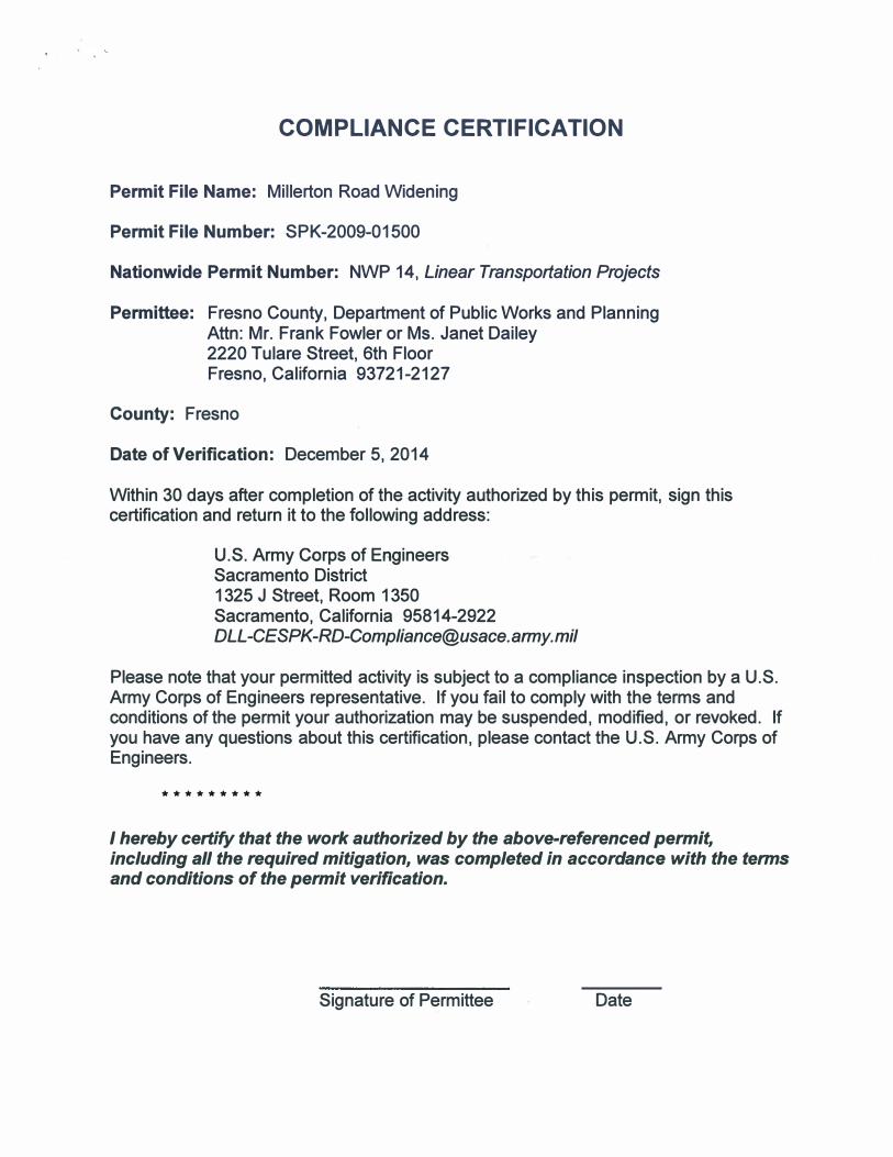
COMPLIANCE CERTIFICATION
Permit File Name: Millerton Road Widening
Permit File Number: SPK-2009-01500
Nationwide PermitNumber: NWP 14, Linear Transportation Projects
Permittee: Fresno County, Department of Public Works and PlanningAttn: Mr. Frank Fowler or Ms. Janet Dailey 2220 Tulare Street, 6th Floor Fresno, California 93721-2127
County: Fresno
Date of Verification: December 5, 2014
Within 30 days after completion of the activity authorized by this permit, sign this certification and return it to the following address:
U.S. Army Corps of Engineers. Sacramento District 1325 J Street, Room 1350 Sacramento, California 95814-2922 [email protected]
Please note that your permitted activity is subject to a compliance inspection by a U.S. Army Corps of Engineers representative. If you fail to comply with the terms and conditions of the permit your authorization may be suspended, modified, or revoked. If you have any questions about this certification, please contact the U.S. Army Corps of Engineers.
*********
I hereby certify that the work authorized by the above-referenced permit, including all the required mitigation, was completed in accordance with the terms and conditions of the permit verification.
Signature of Permittee Date

603
/ /
i j
I /
/-/\\ ./
8
j Madera County
Q} 0
� Project Site
El Fresno County
SOURCE: ESRI Data, 2007;AES 2009 Millerton Road Widening Project Nationwide Pennit 14 Pre-Construction Notification 1207518 •
Figure 1
Regional Location

-- Proposed Road Alignment
LEGEND
Channel
IMPACTS TO WETLAND FEATURES
Roadside Oltch
-- 0.0389 ac -- 0.081 ac
Ephemera) Drainage Seasonal Wetland
-- 0.010 ac r:::::J 0.233 ac
Frlant • Kem Canal
r-n-r- 0.0007 ac
SOURCE: Provost .t: Pritchard Enginccrina Oroup. 2007: Espinosa Survcyina. 2009: Aerial Exprcn acri•I photognphy. 6'2007: AES. 2014 Mllltrton Road JYidtning Projtcl Natlonwldt Pt rm II I 4 Pn!.Cons1n1c1lon Notljlcatlon I 107518 •
Figures Project Design
<

-- Proposed Road Alignment
IMPACTS TO WETlAND FEAlURES
Ch1nnel Roadside Ottch
-- 0.0389 ac -- 0,081 ae
Ephemeral Drainage Seasonal Weaand
--- o.01oac
Frlant- Kern Canal
0.0007 ac
0.233 ac
SOURCE: Provost & Prilchard FAginccring Group, 2007: Espinosa Survoying,2009'.Acrial Exprcss aari11I ph<>1:asraphy. 6/2007; AES. 2014 Milltrton Road Widening Projtcl iVatiomi•lde Pm11it 14 Pre.Conslntction Notification/ 107518 •
Figure 5 Project Design - Sheet I

-- Proposed Road Alignment
LEGEND
IMPACTS TO WETLAND FEATURES
Channel Roadside Ditch -- 0.0389 llC -- 0.081 ec::
Ephemeral Drainage Seasonal Wedand
--- 0.010 ac c::J 0.233 ac
Friant • Kern Canal
·1 ·· 0.0007 ac
SOURCE: Provost 4 Pritdan:I EnsiJtecrina Oroup, 2007: Espino111 S11rveying, 2009; Aerial Eitprcu acrial photography. 612007; AES. 2014 Milluton Road Widening Projtcl Natlomvldt Pmnlt I 4 Pre.Constnicllon Nollflcollon 1107518 •
Figures Project Design - Sheet 2