appendix d water quality program - vbwd
TRANSCRIPT

Appendix D
Water Quality Program
(Appendix D is divided into 4 parts)
Part 3 Lake Elmo, Goose Lake (North), Goose Lake (South), Horseshoe Lake,
Lake Jane, Klawitter Pond, Kramer Pond (Lake graphs and map of survey results)
Part 1 2012 VBWD Water Quality Data Collection Program
(Narration, Tables D-1 through D-6, Figure D-1 [Avg. water clarity depths], and Figures D-2 and D-3 [Biotic Index Values])
Part 2
Bay Lake, Cloverdale Lake, Lake DeMontreville, Downs Lake, Eagle Point Lake, Echo Lake, Lake Edith
(Lake graphs and map of survey results)
Part 3
Lake Elmo, Goose Lake (North), Goose Lake (South), Horseshoe Lake, Lake Jane, Klawitter Pond, Kramer Pond
(Lake graphs and map of survey results)
Part 4 Long Lake, McDonald Lake, Lake Olson, Rest Area Pond, Silver Lake,
Sunfish Lake, Sunnybrook Lake
(Lake graphs and map of survey results)

LAKE ELMOSUMMER AVERAGE WATER CLARITY
Valley Branch Watershed District
0
2
4
6
8
10
12
14
16
18
0
1
2
3
4
5
6
1945
1950
1955
1960
1965
1970
1975
1980
1985
1990
1995
2000
2005
2010
2015
Secc
hi D
isc
Tran
spar
ency
Dep
th (f
eet)
Secc
hi D
isc
Tran
spar
ency
Dep
th (m
eter
s)
Year
POOR
EXCELLENT
FAIR
GOOD

LAKE ELMO HISTORIC WATER QUALITY DATA Valley Branch Watershed District

LAKE ELMO HISTORIC WATER QUALITY DATA Valley Branch Watershed District

Mann-Kendall/Sen’s Slope Trend Test
(Test Period – 2003 to 2012)
Confidence Level
Test Statistic = 12 Test Significance
99% 12 < 25 Not Significant 95% 12 < 20 Not Significant 90% 12 < 17 Not Significant 80% 12 < 14 Not Significant
Sen’s Slope 0.106 meters/year
Notes: 1. Points shown in the graph are the summer average (June-August) Secchi disc transparency depths. Only years with a calculated summer average based on at least 4 measured values are plotted. At least 5 data points were required to complete the trend test.
LAKE ELMO
MANN-KENDALL TREND ANALYSIS OF SECCHI DISC TRANSPARENCY Valley Branch Watershed District


GOOSE LAKE (NORTH)SUMMER AVERAGE WATER CLARITY
Valley Branch Watershed District
0
1
2
3
4
5
6
7
8
9
0
1
2
3
2002
2003
2004
2005
2006
2007
2008
2009
2010
2011
2012
2013
Secc
hi D
isc
Tran
spar
ency
Dep
th (f
eet)
Secc
hi D
isc
Tran
spar
ency
Dep
th (m
eter
s)
Year
POOR
EXCELLENT
FAIR
GOOD

GOOSE LAKE (NORTH) HISTORIC WATER QUALITY DATA Valley Branch Watershed District

GOOSE LAKE (NORTH) HISTORIC WATER QUALITY DATA Valley Branch Watershed District

!?
Typha sp.
Typha sp.
Typha sp.
Lythrum salicaria
Iris versicolor
Glyceria borealis
Scirpus fluviatilis
Scirpus fluviatilis
Scirpus fluviatilis
Typha sp.
Potamogeton nodosus - 1
Potamogeton nodosus - 1
Elodea nuttallii - 2-3+
Potamogeton nodosus - 2-3
Potamogeton nodosus - 2-3
Potamogeton zosteriformis - 1-2
Elodea nuttallii - 2-3+
Potamogeton sp. - 1
Scirpus fluviatilis
Typha sp.
Potamogeton nodosus - 1
Scirpus fluviatilis
Typha sp.
Eleocharis sp.
Scirpus fluviatilis
Glyceria borealis
Water QualityMonitoring Location
Typha sp.
Glyceria borealis
Elodea nuttallii - 2-3
Potamogeton nodosus - 1
Potamogeton zosteriformis - 1
Potamogeton nodosus - 1-2
Potamogeton nodosus - 1-2
Elodea nuttallii - 2-3
Potamogeton zosteriformis - 1-2
Glyceria borealis
!;N
0 50 100
Meters
0 200 400
Feet
Ba
rr F
oo
ter:
Arc
GIS
10.0
, 2
01
2-0
9-2
5 1
0:1
4 F
ile: I:
\Clie
nt\V
BW
D\D
istr
ict\
Ma
ps\M
acro
ph
yte
Ma
ps\2
01
2\G
oo
se
Lake
N_
Macro
phyte
s_
060
51
2.m
xd
User:
kac2
Imagery Source: 2009 AE
GOOSE LAKE NORTH MACROPHYTESURVEY RESULTS
June 5, 2012Valley Branch Watershed DistrictFIELD NOTES:
- Macrophyte densities estimated as follows: 1=light; 2=moderate; 3=heavy- No macrophytes found in water > 3-4 Feet
Emergent Plants
Floating Leaf Plants
Submerged Aquatic Plants
No Aquatic Vegetation
!? Water Quality Monitoring Location
*Note: Bold red name indicates extremely aggressive/invasive introduced species.
Common Name Scientific Name
Flatstem pondw eed Potamogeton zosteriformis
Longleaf pondw eed Potamogeton nodosus
Narrow leaf pondw eed Potamogeton sp. (narrowleaf)
Slender w aterw eed Elodea nuttallii
Common Name Scientific Name
Blueflag iris Iris versicolor
Cattail Typha sp.
Northern mannagrass Glyceria borealis
Purple loosestrife Lythrum salicaria
River bulrush Schoenoplectus fluviatilis
Spikerush Eleocharis sp.
Submerged Aquatic Plants
Floating Leaf Plants
None Found
Emergent Plants

GOOSE LAKE (SOUTH)SUMMER AVERAGE WATER CLARITY
Valley Branch Watershed District
0
1
2
3
4
5
6
7
8
9
0
1
2
3
2002
2003
2004
2005
2006
2007
2008
2009
2010
2011
2012
2013
Secc
hi D
isc
Tran
spar
ency
Dep
th (f
eet)
Secc
hi D
isc
Tran
spar
ency
Dep
th (m
eter
s)
Year
POOR
EXCELLENT
FAIR
GOOD

GOOSE LAKE (SOUTH) HISTORIC WATER QUALITY DATA Valley Branch Watershed District

GOOSE LAKE (SOUTH) HISTORIC WATER QUALITY DATA Valley Branch Watershed District

!?
456719
Ke
ats
Av N
Sagittaria sp.
Sagittaria sp.
Sagittaria sp.
Lythrum salicariaGlyceria borealis
Phalaris arundinacea
Scirpus fluviatilis
Lythrum salicariaSagittaria sp.
Scirpus fluviatilis
Elocharia sp.
Lythrum salicariaSagittaria sp.
Polygonum amphibium
Phalaris arundinacea
Lythrum salicariaSagittaria sp.
Scirpus fluviatilisLythrum salicariaPolygonum amphibium
Eleocharis sp.
Sagittaria sp.
Scirpus fluviatilis
Scirpus validus
(sporadic growth)
Eleocharis sp.Lythrum salicaria
Polygonum amphibium
Sagittaria sp.
Scirpus validus
Typha sp.
Elodea nuttallii - 1-2
Ceratophyllum demersum - 1-2
Potamogeton pusilus - 1-2
Typha sp. (dead)
Lythrum salicariaPhalaris arundinacea
Elodea nuttallii - 1-2
Potamogeton crispus - 1
Potamogeton pusillus - 1
Phalaris arundinaceaElodea nuttallii - 1-2
Potamogeton pusillus - 2-3
Potamogeton crispus - 1-2
Potamogetoncrispus - 1-2
Elodea nuttallii - 1
Potamogeton crispus - 1 Ceratophyllum demersum - 1Potemogeton crispus - 1
Elodea nuttallii - 1-2
Potamogeton pusilus - 1-2Potemogeton crispus - 1
Elodea nuttallii - 1
Potamogeton crispus - 1
Elodea nuttallii - 1-2
Drepanocladus
Nitella sp. - 3+
Potamogeton crispus (1 plant)Elodea nuttallii - 1
Ceratophyllum demersum - 1
Glyceria borealis
Nitella sp. - 2-3
Ceratophyllum demersum - 1
Elodea nuttallii - 1-2
!;N
0 100 200
Meters
0 400 800
Feet
Ba
rr F
oo
ter:
Arc
GIS
10.0
, 2
01
2-0
9-2
5 1
4:1
2 F
ile: I:
\Clie
nt\V
BW
D\D
istr
ict\
Ma
ps\M
acro
ph
yte
Ma
ps\2
01
2\G
oo
se
Lake
S_
Ma
cro
ph
yte
s_
06
05
09
.mxd
Use
r: k
ac2
Imagery Source: 2009 AE
GOOSE LAKE SOUTH MACROPHYTESURVEY RESULTS
June 5, 2012Valley Branch Watershed District
FIELD NOTES:- Macrophyte densities estimated as follows: 1=light; 2=moderate; 3=heavy- No macrophytes found in lake > 4.0 ft of depth- High water level- Entire shoreline contains Sagittaria sp., Lythrum salicaria, Scirpus fluviatilis, Eleocharis sp., Polygonium amphibium - the most dense areas are mapped- Algal blooms present- Reed canary grass (Phalaris arundinacea) present around entire lake perimeter
Dry
Emergent Plants
Floating Leaf Plants
Submerged Aquatic Plants
No Aquatic Vegetation
!? Water Quality Monitoring Location
*Note: Bold red name indicates extremely aggressive/invasive introduced species.
Coontail Ceratophyllum demersum
Curlyleaf pondw eed Potamogeton crispus
Slender w aterw eed Elodea nuttallii
Small pondw eed Potamogeton pusillus
Stonew ort Nitella sp.
Watermoss Drepanocladus
Common Name Scientific Name
Arrow head Sagittaria sp.
Northern mannagrass Glyceria borealis
Purple loosestrife Lythrum salicaria
River bulrush Schoenoplectus fluviatilis
Softstem bulrush Schoenoplectus tabernaemontani
Spikerush Eleocharis sp.
Water smartw eed Polygonum amphibium
Cattail Typha sp.
Submerged Aquatic Plants
Floating Leaf Plants
None Found
Emergent Plants
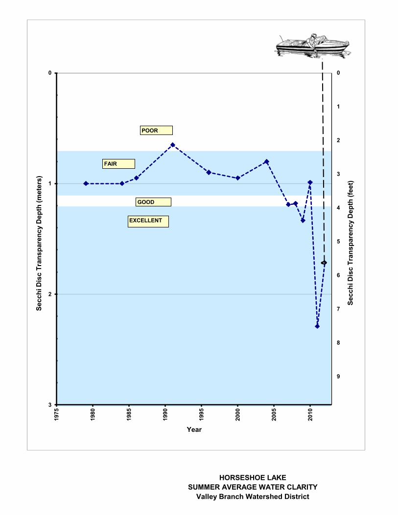
HORSESHOE LAKESUMMER AVERAGE WATER CLARITY
Valley Branch Watershed District
0
1
2
3
4
5
6
7
8
9
0
1
2
3
1975
1980
1985
1990
1995
2000
2005
2010
Secc
hi D
isc
Tran
spar
ency
Dep
th (f
eet)
Secc
hi D
isc
Tran
spar
ency
Dep
th (m
eter
s)
Year
POOR
EXCELLENT
FAIR
GOOD
HORSESHOE LAKE HISTORIC WATER QUALITY DATA Valley Branch Watershed District

HORSESHOE LAKE HISTORIC WATER QUALITY DATA Valley Branch Watershed District

Mann-Kendall/Sen’s Slope Trend Test (Test Period – 2004 to 2012)
Confidence
Level Test Statistic = 11
Test Significance 99% 11 < 18 Not Significant 95% 11 < 15 Not Significant 90% 11 < 13 Not Significant80% 11 > 10 Significant (Increasing)
Sen’s Slope 0.114 meters/year
Notes: 1. Points shown in the graph are the summer average (June-August) Secchi disc transparency depths. Only years with a calculated summer average based on at least 4 measured values are plotted. At least 5 data points were required to complete the trend test.
HORSESHOE LAKE
MANN-KENDALL TREND ANALYSIS OF SECCHI DISC TRANSPARENCY Valley Branch Watershed District

!?
Typha sp.Chara sp - 1-2
Carex sp.
Typha sp.
Carex sp.
Typha sp.
Typha sp.
Typha sp.
Typha sp.
Typha sp.
Scirpus acutus
Scirpus validus
Typha sp.
Scirpus validus
Scirpus fluviatilis
Sparganium eurycarpum
Typha sp.
Typha sp.
Scirpus validus
Typha sp.
Scirpus validus
Typha sp.
Carex sp.
Carex sp.
Scirpus acutus
Typha sp.
Typha sp.
Ceratophyllum demersum - 1
Ceratophyllum
demersum - 1-2
Scirpus validus
Carex sp.
Eleocharis sp.
Potamogeton sp. - 1
Elodea Canadensis - 1-2
Myriophyllum spicatum - 3
Myriophyllum
spicatum - 1
Potamogeton crispus - 1-2Myriophyllum sibiricum - 1
Potamogeton sp. - 1
Typha sp.
Myriophyllum spicatum - 1
Myriophyllum spicatum - 1-2
Potamogeton sp. - 1-2
Stuckenia pectinata - 1Potamogeton crispus - 1-2
Ceratophyllum demersum - 1
Potamogeton sp. - 1-2
Stuckenia pectinata - 1Potamogeton sp. - 1-2
Potamogeton crispus - 1-2
Elodea Canadensis - 1
Potamogeton sp. - 1-2Potamogeton crispus - 1-2
Stuckenia pectinata - 1-2
Potamogeton crispus - 3+Myriophyllum spicatum - 1
Typha sp.
Typha sp.
Scirpus validus
Potamogeton crispus - 1-2Myriophyllum spicatum - 1
Potamogeton pectinatus - 1-2
Ceratophyllum demersum - 1-3
Potamogeton sp. - 1-3
Potamogeton sp. - 1
Ceratophyllum demersum - 1-2
Potamogeton crispus - 1
Potamogeton crispus - 1Myriophyllum spicatum - 1
Potamogeton sp. - 1
Ceratophyllum demersum - 1
Stuckenia pectinata - 1
Elodea Canadensis - 1-2
Potamogeton crispus - 1Potamogeton sp. - 1-2
Ranunculus sp. - 1
Potamogeton crispus - 1-2
Potamogeton sp. - 1-2
Ceratophyllum demersum - 1
Potamogeton crispus - 1Potamogeton pectinatus - 1
Ranunculus sp. - 1
Potamogeton crispus - 1Potamogeton sp. - 1-2
Potamogeton crispus - 1 (sporadic)Ceratophyllum demersum - 1
Water QualitySampling Location
Potamogeton crispus - 1-2
Potamogeton crispus - 1Ceratophyllum demersum - 1
Potamogeton sp. - 1-2Elodea Canadensis - 2-3
Potamogeton crispus - 1
Potamogeton sp. - 1-2Potamogeton crispus - 1-2
Ceratophyllum demersum - 1
Potamogeton crispus - 1
Potamogeton crispus - 1Potamogeton sp. - 1
Stuckenia pectinata - 1-2
Potamogeton crispus - 1-2Myriophyllum spicatum - 1
Elodea Canadensis - 1-3
Potamogeton sp. - 2-3
Ceratophyllum demersum - 2-3
Stuckenia pectinata - 1-2
Potamogeton crispus - 1-2Ceratophyllum demersum - 1-2
Potamogeton crispus - 1-2Myriophyllum spicatum - 1
Ceratophyllum demersum - 3
!;N
0 200 400
Meters
0 500 1,000
Feet
Ba
rr F
oote
r: D
ate
: 1
0/0
3/2
012
5:0
5:5
2 P
M F
ile:
I:\
Clie
nt\
VB
WD
\Dis
tric
t\M
ap
s\M
acro
ph
yte
Ma
ps\2
01
2\H
ors
esh
oeL
k_
Ma
cro
ph
yte
s_
06
041
2.m
xd
Use
r:
kac2
Imagery Source: 2009 AE
HORSESHOE LAKE MACROPHYTESURVEY RESULTS
June 4, 2012Valley Branch Watershed District
FIELD NOTES:- Macrophyte densities estimated as follows: 1=light; 2=moderate; 3=heavy- Densities generally not noted for emergent and floating leaf plants- No macrophytes found in water >5-6’- Carex sp., Eleocharis sp. and Polygonum sp. found along entire shoreline- High water level- Algal mats present near shore
Emergent Plants
Floating Leaf Plants
Submerged Aquatic Plants
No Aquatic Vegetation
!? Water Quality Monitoring Location
*Note: Bold red name indicates extremely aggressive/invasive introduced species.
Common Name Scientific Name
Canadian w aterw eed Elodea Canadensis
Coontail Ceratophyllum demersum
Curlyleaf pondweed Potamogeton crispus
Eurasian watermilfoil M yriophyllum spicatum
Northern w atermilfoil Myriophyllum sibricum
Pondw eed Potamogeton sp.
Sago pondw eed Potamogeton pectinatus
Common Name Scientific Name
Cattail Typha sp.
Common bur-reed Sparganium eurycarpum
Hardstem bulrush Scirpus acutus
River bulrush Scirpus fluviatilis
Sedge Carex sp.
Softstem bulrush Scirpus validus
Spikerush Eleocharis sp.
Submerged Aquatic Plants
None Observed
Floating Leaf Plants
Emergent Plants

LAKE JANESUMMER AVERAGE WATER CLARITY
Valley Branch Watershed District
0.0
2.0
4.0
6.0
8.0
10.0
12.0
14.0
16.0
0
1
2
3
4
5
1950
1955
1960
1965
1970
1975
1980
1985
1990
1995
2000
2005
2010
Secc
hi D
isc
Tran
spar
ency
Dep
th (m
eter
s)
Year
POOR
EXCELLENT
FAIR
GOOD

LAKE JANE HISTORIC WATER QUALITY DATA Valley Branch Watershed District

LAKE JANE HISTORIC WATER QUALITY DATA Valley Branch Watershed District


KLAWITTER PONDSUMMER AVERAGE WATER CLARITY
Valley Branch Watershed District
0
1
2
3
4
5
6
7
8
9
0
1
2
3
2000
2001
2002
2003
2004
2005
2006
2007
2008
2009
2010
2011
2012
2013
Secc
hi D
isc
Tran
spar
ency
Dep
th (f
eet)
Secc
hi D
isc
Tran
spar
ency
Dep
th (m
eter
s)
Year
POOR
EXCELLENT
FAIR
GOOD

KLAWITTER POND HISTORIC WATER QUALITY DATA Valley Branch Watershed District

KLAWITTER POND HISTORIC WATER QUALITY DATA Valley Branch Watershed District

Mann-Kendall/Sen’s Slope Trend Test (Test Period – 2003 to 2012)
Confidence
Level Test Statistic = -7
Test Significance 99% 3 < 30 Not Significant 95% 3 < 23 Not Significant 90% 3 < 20 Not Significant 80% 3 < 16 Not Significant
Sen’s Slope 0.004 meters/year
Notes: 1. Points shown in the graph are the summer average (June-August) Secchi disc transparency depths. Only years with a calculated summer average based on at least 4 measured values are plotted. At least 5 data points were required to complete the trend test.
KLAWITTER POND
MANN-KENDALL TREND ANALYSIS OF SECCHI DISC TRANSPARENCY Valley Branch Watershed District

KRAMER PONDSUMMER AVERAGE WATER CLARITY
Valley Branch Watershed District
0
1
2
3
4
5
6
7
8
9
0
1
2
3
2002
2003
2004
2005
2006
2007
2008
2009
2010
2011
2012
2013
Secc
hi D
isc
Tran
spar
ency
Dep
th (f
eet)
Secc
hi D
isc
Tran
spar
ency
Dep
th (m
eter
s)
Year
POOR
EXCELLENT
FAIR
GOOD

KRAMER POND HISTORIC WATER QUALITY DATA Valley Branch Watershed District

KRAMER POND HISTORIC WATER QUALITY DATA Valley Branch Watershed District

!?Water QualityMonitoring Location
3.5’ deep silt / clay
!;N
0 50 100
Meters
0 200 400
Feet
Ba
rr F
oo
ter:
Arc
GIS
10.0
, 2
01
2-0
9-2
4 1
1:1
4 F
ile:
I:\C
lien
t\V
BW
D\D
istr
ict\
Map
s\M
acro
phyte
Map
s\2
01
2\K
ram
erP
d_
Ma
cro
ph
yte
s_0
60
51
2.m
xd
Use
r: k
ac2
Imagery Source: 2009 AE
KRAMER POND MACROPHYTESURVEY RESULTS
June 5, 2012Valley Branch Watershed DistrictFIELD NOTES:
- No macrophytes found in water > 1-2 feet.- Macrophyte densities estimated as follows: 1=light; 2=moderate; 3=heavy- High water level
Emergent Plants
Floating Leaf Plants
Submerged Aquatic Plants
No Aquatic Vegetation
!? Water Quality Monitoring Location
Submerged Aquatic Plants
Floating Leaf Plants
None Found
Emergent Plants
None Found
None Found