appendix e hdr engineering report - energy.gov · 2012. 11. 20. · confederated tribes and bands...
TRANSCRIPT

Drop 4 Hydropower Project July 13, 2012 Environmental Assessment
Appendix E HDR Engineering Report


Drop 4 Hydropower Project July 13, 2012 Environmental Assessment
Appendix F Resource Reports


Confederated Tribes and Bands of the Yakama Nation Wildlife Resource Management Program
P.O. Box 151, (4690 S.R. 22), Toppenish, WA 98948 (509) 865-5121 fax: (509)865-3619 www.ynwildlife.org
To: Rocco Clark Jr.; BIA Environmental Coordinator From: Mark Nuetzmann; WRMP Wildlife Biologist Through: LeRoy Adams Jr.; WRMP Program Manager Date: January 4, 2012 Subject: Drop 4 Project-Wildlife Report The Yakama Nation proposes to install an inflow turbine at Drop 4 on the Wapato Irrigation Project (WIP) main canal to generate approximately one megawatt of supplemental hydroelectric power. The project site is located two miles southwest of Harrah, Washington near the intersection of Harrah Drain and McDonald Roads where the irrigation canal undergoes a 20-foot elevation drop. To increase the electrical generation potential at Drop 4, the drop height will be raised by 3 to 4 feet. This will be accomplished by backfilling the headworks and further excavating the tailrace. The project will also involve the construction of a small powerhouse, a downstream diversion structure to route some of the water used in power generation into Harrah Drain, and approximately one-quarter mile of above-ground transmission line between Harrah Drain and the power plant. Temporary construction easements may be required for site access and construction staging. Preliminary project design was developed by Yakama Power (YP) staff and through consultation with electrical and mechanical engineers. Upon completion of the project, the Drop 4 hydroelectric system would be owned by YN and operated by YP. The species accounts below are those federally listed and candidate species that are could potentially be located within Yakima County according to USFWS (see attached). Northern Spotted Owl and associated habitat The project area does not contain spotted owl habitat and is outside of any forested stands.
Confederated Tribes and Bands of the Yakama Nation Wildlife Resource Management Program
P.O. Box 151, (4690 S.R. 22), Toppenish, WA 98948 (509) 865-5121 fax: (509)865-3619 www.ynwildlife.org
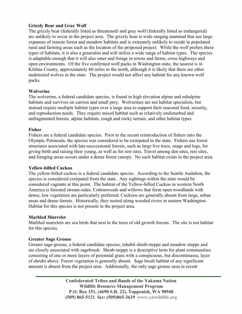
Grizzly Bear and Gray Wolf The grizzly bear (federally listed as threatened) and gray wolf (federally listed as endangered) are unlikely to occur in the project area. The grizzly bear is wide ranging mammal that use large expanses of remote forest and meadow habitats and is extremely unlikely to reside in populated rural and farming areas such as the location of the proposed project. While the wolf prefers these types of habitats, it is also a generalist and will utilize a wide range of habitat types. The species is adaptable enough that it will also enter and forage in towns and farms, cross highways and open environments. Of the five confirmed wolf packs in Washington state, the nearest is in Kittitas County, approximately 60 miles to the north, although it is likely that there are other undetected wolves in the state. The project would not affect any habitat for any known wolf packs. Wolverine The wolverine, a federal candidate species, is found in high elevation alpine and subalpine habitats and survives on carrion and small prey. Wolverines are not habitat specialists, but instead require multiple habitat types over a large area to support their seasonal food, security, and reproduction needs. They require mixed habitat such as relatively undisturbed and unfragmented forests, alpine habitats, rough and rocky terrain, and other habitat types. Fisher Fishers are a federal candidate species. Prior to the recent reintroduction of fishers into the Olympic Peninsula, the species was considered to be extirpated in the state. Fishers use forest structures associated with late-successional forests, such as large live trees, snags and logs, for giving birth and raising their young, as well as for rest sites. Travel among den sites, rest sites, and foraging areas occurs under a dense forest canopy. No such habitat exists in the project area. Yellow-billed Cuckoo The yellow-billed cuckoo is a federal candidate species. According to the Seattle Audubon, the species is considered extirpated from the state. Any sightings within the state would be considered vagrants at this point. The habitat of the Yellow-billed Cuckoo in western North America is forested stream-sides. Cottonwoods and willows that form open woodlands with dense, low vegetation are particularly preferred. Cuckoos are generally absent from large, urban areas and dense forests. Historically, they nested along wooded rivers in eastern Washington. Habitat for this species is not present in the project area. Marbled Murrelet Marbled murrelets are sea birds that nest in the trees of old growth forests. The site is not habitat for this species. Greater Sage Grouse Greater sage-grouse, a federal candidate species, inhabit shrub-steppe and meadow steppe and are closely associated with sagebrush. Shrub-steppe is a descriptive term for plant communities consisting of one or more layers of perennial grass with a conspicuous, but discontinuous, layer of shrubs above. Forest vegetation is generally absent. Sage brush habitat of any significant amount is absent from the project area. Additionally, the only sage grouse seen in recent

Confederated Tribes and Bands of the Yakama Nation Wildlife Resource Management Program
P.O. Box 151, (4690 S.R. 22), Toppenish, WA 98948 (509) 865-5121 fax: (509)865-3619 www.ynwildlife.org
memory are those that were released by the tribe in the East Satus area approximately 20 miles away. Mardon Skipper The mardon skipper, Polites mardon, is a federal candidate species. This small butterfly is found in only four disjunct geographic locations worldwide, two locations in Washington and one in Oregon and California. Within Washington, the species inhabits prairies of the south Puget Sound lowlands and meadows within and around the Yakama Nation. The species is found in open grassland sites and often associated with Idaho fescue, a species that is not found at the project area. Sites can vary in size from ½ acre or less meadows to larger grassland complexes. Site conditions can range from dry, open ridgetops to areas associated with wetlands or riparian habitats. Road construction through meadow habitat can threaten this species as well as other plant and animal species that inhabit meadow ecosystems. Ute Ladies’-Tresses Ute Ladies’-Tresses, Spiranthes diluvialis, is a federal endangered species. This species is known to occur in Okanogan and Chelan counties, although there is a great deal of uncertainty as to the species’ actual distribution due to the limited extent of surveys, and the fact an occupied site may have to be surveyed for several years before these orchids flower and can be identified. The Montana Natural Heritage website describes these plants as being “restricted to calcareous, temporarily inundated wet meadow zones and segments of channels and swales where there is stable subsurface moisture and relatively low vegetation cover”. No such habitat is located within the project area. Whitebark Pine Whitebark pine (Pinus albicaulis) is a federal Candidate Species found in montane and subalpine forests. The proposed project is not located in this habitat. The proposed project is anticipated to have no effect on the federally listed and candidate species discussed above. If you have any questions or need additional information, please call me at 865-5121 x6333 or email me at [email protected].

LISTED AND PROPOSED ENDANGERED AND THREATENED SPECIES AND CRITICAL HABITAT; CANDIDATE SPECIES; AND SPECIES OF CONCERN
IN YAKIMA COUNTY AS PREPARED BY
THE U.S. FISH AND WILDLIFE SERVICE CENTRAL WASHINGTON FIELD OFFICE
(Revised August 1, 2011)
LISTED
Bull trout (Salvelinus confluentus) – Columbia River DPS Gray wolf (Canis lupus) Grizzly bear (Ursus arctos horribilis) Marbled murrelet (Brachyramphus marmoratus) Northern spotted owl (Strix occidentalis caurina)
Major concerns that should be addressed in your Biological Assessment of project impacts to listed animal species include:
1. Level of use of the project area by listed species.
2. Effect of the project on listed species' primary food stocks, prey species, and foraging areas in all areas influenced by the project.
3. Impacts from project activities and implementation (e.g., increased noise levels, increased human activity and/or access, loss or degradation of habitat) that may result in disturbance to listed species and/or their avoidance of the project area.
Spiranthes diluvialis (Ute ladies’tresses)
Major concerns that should be addressed in your Biological Assessment of project impacts to listed plant species include:
1. Distribution of taxon in the project vicinity.
2. Disturbance (trampling, uprooting, collecting, etc.) of individual plants and loss of habitat.
3. Changes in hydrology where taxon is found.
DESIGNATED
Critical habitat for the bull trout Critical habitat for the northern spotted owl
PROPOSED
None

CANDIDATE
Fisher (Martes pennanti) West Coast DPS Greater sage grouse (Centrocercus urophasianus) – Columbia Basin DPS Mardon skipper (Polites mardon) North American wolverine (Gulo gulo luteus) – contiguous U.S. DPS Yellowbilled cuckoo (Coccyzus americanus) Pinus albicaulis (whitebark pine)
SPECIES OF CONCERN
Bald eagle (Haliaeetus leucocephalus) Black swift (Cypseloides niger) Burrowing owl (Athene cunicularia) Ferruginous hawk (Buteo regalis) Larch Mountain salamander (Plethodon larselli) Loggerhead shrike (Lanius ludovicianus) Longeared myotis (Myotis evotis) Northern goshawk (Accipiter gentilis) Olivesided flycatcher (Contopus cooperi) Pacific lamprey (Lampetra tridentata) Pallid Townsend's bigeared bat (Corynorhinus townsendii pallescens) Peregrine falcon (Falco peregrinus) Redband trout (Oncorhynchus mykiss) River lamprey (Lampetra ayresi) Sagebrush lizard (Sceloporus graciosus) Sharptail snake (Contia tenius) Townsend’s ground squirrel (Spermophilis townsendii) Western brook lamprey (Lampetra richardsoni) Western gray squirrel (Sciurus griseus griseus) Westslope cutthroat trout (Oncorhynchus clarki lewisi) Astragalus columbianus (Columbia milkvetch) Calochortus longebarbatus var. longebarbatus (longbearded sego lily) Castilleja cryptantha (obscure paintbrush) Cryptantha leucophaea (gray cryptantha) Cypripedium fasciculatum (clustered lady’sslipper) Erigeron basalticus (basalt daisy) Lomatium tuberosum (Hoover’s desertparsley) Sisyrinchium sarmentosum (pale blueeyed grass) Tauschia hooveri (Hoover’s tauschia)

1
Fisheries Resource
Management
PO BOX 151 Toppenish, WA 98948
509-865-2255
To: Peggy Williamson—CHMM— Fulcrum Environmental Consulting From: Nathan Longoria—Fisheries Biologist Reviewed: Ryan DeKnikker— Fisheries Biologist—YRWP Date: 05-30-12 Subject: Fisheries comments on invasive species mitigation in concern to Drop 4 The following is a statement of comments in regards to the installation of Drop 4 and mitigation practices for invasive species during the construction process. Species Considered Vertebrates Lepomis gibbosus, pumpkinseed sunfish Lepomis macrochirus, bluegill sunfish Micropterus dolomieu, smallmouth bass Micropterus salmoides, largemouth bass Pomoxis nigromaculatus, black crappie Carassius auratus, goldfish Cyprinus carpio, common carp Pimephales promelas, fathead minnow Ameiurus melas, black bullhead Ameiurus nebulosus, brown bullhead Ictalurus punctatus, channel catfish Perca flavescens, yellow perch

2
Invertebrates (These species are not present in the county, but should be mitigated against due to their prolific potential) Dreissena polymorpha, Zebra mussel Dreissena bugensis, Quagga mussel Potamopyrgus antipodarum, New Zealand mud snail Plants Nasturtium officinale, water-cress Callitriche stagnalis, pond water-starwort Myriophyllum aquaticum, parrot feather Myriophyllum spicatum, Eurasian water-milfoil Iris pseudacorus, yellow iris Lythrum salicaria, purple loosestrife Nymphoides peltata, yellow floating-heart Nymphaea odorata, white water-lily Echinochloa crusgalli, Barnyard grass Potamogeton crispus, curly pondweed Other Biologics Batrachochytrium dendrobatidis, Chytrid fungus Saprolegnia sp.
Mitigation of Translocation
During the construction process there are multiple pathways that can result in translocation of invasive species. Through mitigation practices, one can control the introduction of invasive species in a practical way. The following mitigation prescriptions are recommended by the USFWS to control the above listed species. All in Stream Equipment (from Excavators to Boots and Rakes)
All equipment will be clean, inspected for leaks, and in good working order. Remove any visible invertebrates, aquatic plants, and soil. Pressure wash equipment with hot water (≥120° F) and allow to dry completely (4+ hours). Scrub all small gear and equipment, soak in hot water (≥120° F) for at least 5 minutes, and allow to dry completely (4+hours). Monitor and document the ambient air temperatures Document that heavy equipment was inspected. Monitor the water soak temperature and the soak time to meet stated targets. Conduct a secondary visual inspection after cleaning and drying. If not properly cleaned, Re-scrub, re-soak, re-dry, and re-inspect the equipment.
These prescriptions should be conducted before entering the water for the first time and after the completion of work.

3
Plants and Seed A licensed nursery will provide all trees and shrubs, and plants will be professionally inspected to identify any potential hazards within 48 hours of delivery to project site.

Drop 4 Hydropower Project July 13, 2012 Environmental Assessment
Appendix G Comparison Matrix: Issues Eliminated from Study

Drop 4 Hydropower Project Appendix G - 1 June 13, 2012 Environmental Assessment
Appendix G Comparison Matrix: Issues Eliminated from Detailed Study
US Statutes, Executive Order, Or Identified Issue
Existing Conditions Environmental Consequences Identified Best Management or Mitigation Measures Alternative A No Action
Alternative B Proposed Project Alternative A No Action
Alternative B Proposed Project
Floodplain Management
The WIP Main Canal in the vicinity of the Drop 4 project is not located within a floodplain or floodway. The proposed project is not located within published US Federal Emergency Management Act (FEMA) mapping areas because it is tribal property and the project area is substantially removed from the primary Yakima River and Toppenish Creek flood area. The project is not identified in the Yakima County Geographical Information System (GIS) – Washington Land Information Portal (LIP) as being within a floodplain. The Yakima County GIS LIP identifies the Main Canal as a manmade canal. Refer to Appendix H for the FEMA Flood Insurance Rate Map (FIRM) and the Yakima County GIS LIP map. Refer to Appendix H for Floodplain documentation.
No Change Under the proposed project no change to the regional floodplains, floodways, or floodplain management practices would occur.
None Required None Required
Coastal Zone Management Act
The proposed project is located in Yakima County, which does not have any boundaries in direct contact with coastlines. The proposed action is not under the jurisdiction of the Coastal Zone Management Act. See Appendix I for a copy of the Coastal Zone Counties in Washington State
No Change No Change None Required None Required
Sole Source Aquifers
The proposed project is not within a Sole Source Aquifer area. There are no proposed or pending Sole Source Aquifer designations in Yakima County. See Appendix J for a listing of Sole Source Aquifers in Washington State.
No Change No Change None Required None Required
Wild and Scenic Rivers Act
There are three Wild and Scenic Rivers in the State of Washington – Klickitat, Skagit, and White Salmon. None of these are in the project area. See Appendix K for a listing of Washington State Wild and Scenic Rivers.
No Change No Change None Required None Required
Farmland Protection Policy Act
This Drop 4 hydropower facility will be constructed within the existing WIP right-of-ways. This project will not result in farmland being removed from production or increase the density in this rural area. According to the United States Department of Agriculture (USDA) Web Soil Survey (WSS) data soil at the project site is primarily Warden silt loam, a non-hydric soil. The area of interest (AOI) was established as a conservative boundary to assist the Cultural and Archeological Survey resource report request. The AOI includes the construction area, access roads, and temporary construction staging and materials lay down areas. The WSS identified the majority of the AOI as prime farmland if irrigated. However approximately 0.3 acres of farmland of unique importance were identified within the AOI predominately located adjacent to the canal and spillway and within the current WIP right-of-way or gravel surfaced access roads. See Appendix L for USDA Soils information. According to the 2011 Cultural Monitoring report the soils located adjacent to the canal banks and the spillway are likely fill material built-up when the canal was constructed.
WIP will continue to operate the Main Canal and spillway using the existing right-of-ways and access roadways set aside for the purpose of irrigation conveyance in the 1930s.
Potential soil disturbing activities during construction are expected to be less than 0.125 acres (5,200 sf) total and be contained within the existing WIP right-of-way. Adjacent areas proposed for construction staging and material lay down are periodically mowed by the private landowner and will not require modification to the soil surface, such as grading or compaction, prior to temporary construction use.
None Required None Required (see Soils in Table - Issues Identified with a Minor Consequence)

Drop 4 Hydropower Project Appendix G - 2 June 13, 2012 Environmental Assessment
US Statutes, Executive Order, Or Identified Issue
Existing Conditions Environmental Consequences Identified Best Management or Mitigation Measures Alternative A No Action
Alternative B Proposed Project Alternative A No Action
Alternative B Proposed Project
Environmental Justice
There is no adverse environmental justice impact associated with the project. Environmental Justice is the fair treatment and meaningful involvement of all people regardless of race, color, national origin, or income with respect to the development, implementation, and enforcement of environmental laws, regulations, and policies. EPA has this goal for all communities and persons across this Nation. It will be achieved when everyone enjoys the same degree of protection from environmental and health hazards and equal access to the decision-making process to have a healthy environment in which to live, learn, and work. According to EPA EJ View web site the population in the Drop 4 area are identified as that has 40 to 200 persons per square mile, 40 to 100% who are identified as minorities, and 10 to 20% are identified with a per capita annual income of $16,000. By comparison the United States Census Bureau web site indicates that in Yakima County has a 2010 population of approximately 243,000 persons, an average population of 56.6 persons per square mile in 2010, a per capita annual income of $19,325 in 2010, and an average of 21.8% of the population below the poverty line in 2006 to 2010. According to the Yakima County Profile web page Yakima County’s unemployment rate has risen every year for the last four years, and the rate edged upwards from 9.7 percent in 2010 to 9.9 percent in 2011. Roughly 2 percent of total covered employment in Washington state was in agriculture. In Yakima County, on an annual average basis, almost one in four jobs is an agricultural job (25%). According to the Yakima County Profile page the high percentage of agricultural work has a stabilizing effect on the Yakima County economy. Refer to Appendix M for Environmental Justice Documentation.
No Change Approximately $168,000 of new seasonal revenue will be generated that can be utilized to fund differed maintenance and capital improvement projects on WIPs system. The project does not unfairly displace populations or impose environmental or health hazards on any specific population group. As a result of the project approximately 3 design and inspection professionals and approximately 20 local workers spanning 8 separate trades during the estimated 8 to 9 month construction project will be created. At the conclusion of the project one full time equivalent and one part time equivalent employment position will be available. Increasing potential short term temporary employment of approximately 20 workers and long term employment of one full time equivalent and one part time equivalent employment position in a community that has approximately 24,000 unemployed individuals, while of minor benefit, is not a significant consequence.
None Required None required as environmental justice consequences of the proposed action have minor beneficial consequence.
Siting of Projects Near Hazardous Operations
The proposed project is not located near a hazardous operation that could adversely affect the project. EPA's Enviromapper identified two potential hazardous facilities near the project site. Both are located downgradient and neither present a significant hazard to construction or operation of a small-scale hydroelectric power plant. See Appendix N for a copy of the Enviromapper documentation and Washington State Department of Ecology Facility Site Atlas.
No Change No Change None Required None required

Drop 4 Hydropower Project July 13, 2012 Environmental Assessment
Appendix H Floodplain and Wetlands Documentation


Ecology Home > Core Services > GIS Home > GIS Data > FEMA Flood Data > Q3 Flood Image
Copyright © Washington State Department of Ecology. See http://www.ecy.wa.gov/copyright.html.
Page 1 of 1FEMA Q3 Flood Metadata
6/6/2012http://www.ecy.wa.gov/services/gis/data/flood/q3image.asp?name=yakima

YN Drop 4 Vicinity
Jun 11, 2012
This map is for general reference only. The US Fish and Wildlife Service is notresponsible for the accuracy or currentness of the base data shown on this map. Allwetlands related data should be used in accordance with the layer metadata found onthe Wetlands Mapper web site.
User Remarks:
Yakima County GIS - Washington Land Information Portal
[Print Map][Close Map]
Map Center: Range:18 Township:10 Section:4 2008 Ortho Photography
City Limits Sections Contours
Existing Shoreline Environments: Conservative/Natural/Rural/Urban Potential Wetlands Local Wetland Inventory Stream Type - 2006 CAO
1/2/3/4/4 or 5/Undetermined/5/Man-Made
WWW.YAKIMAP.COMYakima County GIS
128 N 2nd Street Yakima, WA 98901
(509)574-2992
MAP AND PARCEL DATA ARE BELIEVED TO BE ACCURATE, BUT ACCURACY IS NOT GUARANTEED; THIS IS NOT A LEGAL DOCUMENT AND SHOULD NOT BE SUBSTITUTED FOR A TITLE SEARCH, APPRAISAL, SURVEY, FLOODPLAIN OR ZONING VERIFICATION
Copyright (C) 2012 Yakima County GIS
Printed On: 6/12/2012 8:40:42 AM
Page 1 of 1Yakima County GIS
6/12/2012http://www.yakimap.com/servlet/com.esri.esrimap.Esrimap?name=YakGISH&Cmd=Print...

Yakima County GIS
http://www.yakimap.com/WebMaps/legend.htm[6/11/2012 8:14:46 AM]
Urban Service Area Boundary(YCC Title 15A)
Urban Growth Boundary
Yakima County ZoningYCC Title 15
Forest Watershed (FW)
Agriculture (AG)
Remote/Extremely Limited (R/ELDP)
Mountain Rural (MR)
Valley Rural
Rural Transitional (RT)
Rural Settlement (RS)
Highway/Tourist Commerical (HC)
Mining (MIN)
Planned Development (PD)
Single Family Residential (R-1)
Two Family Residential (R-2)
Multi-Family Residential (R-3)
Professional Business (B-1)
Local Business (B-2)
Commercial (C)
Industrial (I)
City Limit
Federal Land/Tribal Trust
Yakama Nation Closed Area
Yakima County Urban Area ZoningYCC Title 15A
Suburban Residential (SR)
Single Family Residential (R1)
Two Family Residential (R2)
Multi-Family Residential (R3)
Professional Business (B1)
Local Business (B2)
Historical Business (HB)
Small Convenience Center (SCC)
Large Convenience Center (LCC)
Central Business District (CBD)
General Commercial (GC)
Light Industrial (M1)
Heavy Industrial (M2)
City of Yakima Zoning(SR) Suburban Residential
(R-1) Single-Family Residental
(R-2) Two-Family Residental
(R-3) Multi-Family Residental
(B-1) Professional Business

Yakima County GIS
http://www.yakimap.com/WebMaps/legend.htm[6/11/2012 8:14:46 AM]
(B-2) Local Business
(HB) Historical Business
(SCC) Small Convenience Center
(LCC) Large Convenience Center
(CBD) Central Business District
(GC) General Commercial
(M-1) Light Industrial
(M-2) Heavy Industrial
(RD) Regional Development
(AS) Airport Safety
Yakima County Plan2015 DesignationsRural Settlement
Rural Self-Sufficient
Rural Remot/Limited Development
Rural Transitional
Forest Resource
Agricultural Resource
Urban (City Limit)
Urban (Urban Growth Area)
Federal/Yakama Nation Trust Land/Cosed Area
City of YakimaFuture Landuse Designations
Low Density Residential
Medium Density Residential
High Density Residential
Professional Office
Neighborhood Commerical
Large Convenience Center
Arterial Commercial
CDB Core Commerical Industrial
Industrial
Flood PlainFlood Way
Flood Plain
Perennial Stream
Intermittent Stream
Lake or Pond
Canal or Ditch
Aquaduct/Siphon
Critical AreasConservancy Wetlands
Natural Wetlands

Yakima County GIS
http://www.yakimap.com/WebMaps/legend.htm[6/11/2012 8:14:46 AM]
Rural Wetlands
Urban Wetlands
Type 1 Stream
Type 2 Stream
Type 3 Stream
Type 4 Stream
Type 4 or 5 Stream
Undetermined Stream
Type 5 Stream
Man-Made Stream
Potential Wetlands - Local Inventory
Utilities:City of Yakima Water Pipes
City of Yakima Sewer Pipes
Nob Hill Water Pipes
Terrace Heights Water Pipes
Terrace Heights Sewer Pipes

Drop 4 Hydropower Project July 13, 2012 Environmental Assessment
Appendix I Coastal Zone Documentation

SEA Program Home > CZM Home > Washington State Coastal Zone Management (CZM) Program
Washington State Coastal Zone Management (CZM) Program
Washington State’s coastal zone management program was approved by the federal government in 1976, making it the first to be approved. The program applies to the fifteen coastal counties which front on salt water.
The terms and features of a state’s approved CZM program are provided in what is commonly known as a state’s “CZM Program Document.” Washington’s program document, Managing Washington’s Coast was most recently updated in 2003.
One of the features of the federal CZM program important to the states is “Federal Consistency.” This simply means that any public federal project carried out by a federal agency, or private project licensed or permitted by a federal agency, or carried out with a federal grant, must be determined to be consistent with the state's CZM program.
The federal Coastal Zone Management Act also provides the states with special funding to assist in making improvements to their state CZM Program. Washington State participates in this voluntary CZM Improvement Grants Program which also goes by the shorter, but more bureaucratic name, Section 309 Program, after its section in the Coastal Zone Management Act. Washington State has used these funds primarily to update and amend the Shoreline Master Program Guidelines under the state’s Shoreline Management Act.
Coastal water quality has always been an important part of the federal – state coastal zone management program. In 1992 Congress provided for increased emphasis on coastal nonpoint pollution. Washington, along with other states in the national CZM program is developing a Coastal Nonpoint Pollution Management plan.
Washington State also participates in the federal Coastal and Estuarine Land Conservation Program (CELCP). The purpose of CELCP is to protect important coastal and estuarine areas having significant conservation, recreation, ecological, historical, or aesthetic values, and threatened by conversion. Although dedicated grant funds have not yet been authorized by Congress, a state plan has been drafted to assure Washington's eligibility for future participation.
To inquire about a Federal Consistency Determination, send an email to the Federal Consistency Coordinator, or telephone (360) 407-6068.
To ask a question about Washington’s Coastal Zone Management Program, send an email to Brian Lynn
Copyright © Washington State Department of Ecology. See http://www.ecy.wa.gov/copyright.html.
Page 1 of 1Coastal Zone Management Program
6/6/2012http://www.ecy.wa.gov/programs/sea/czm/prgm.html

Drop 4 Hydropower Project July 13, 2012 Environmental Assessment
Appendix J Sole Source Aquifer Documentation

TroutdaleAquiferSystem
North FlorenceDunal Aquifer
EasternSnake RiverPlain Aquifer
LewistonBasin
Aquifer
Central PierceCounty Aquifer
CedarValleyAquifer
Vashon-MauryIsland Aquifer
Cross ValleyAquifer
Spokane ValleyRathdrum
Prairie Aquifer
Newberg AreaAquifer
MarrowstoneIsland Aquifer
CamanoIslandAquifer
WhidbeyIslandAquifer
GuemesIslandAquifer
C a l i f o r n i aC a l i f o r n i a
W a s h i n g t o nW a s h i n g t o n
U t a hU t a hN e v a d aN e v a d a
W y o m i n gW y o m i n g
O r e g o nO r e g o n
M o n t a n aM o n t a n a
I d a h oI d a h o
B r i t i s hB r i t i s hC o l u m b i aC o l u m b i a A l b e r t aA l b e r t a
S a s k a t c h e w a nS a s k a t c h e w a n
Snak
e R
iver
Columbia River
Mis
sour
i Riv
er
GreatSaltLake
Tacoma
Seattle Spokane
Portland
Boise
.
Designated Sole Source Aquifersin EPA Region 10
Idaho, Oregon, Washington(None in Alaska)
Map Created 7/21/20080 100 200 30050
Kilometers
Legend
Sole Source AquifersAquifer Area
Source Area

Drop 4 Hydropower Project July 13, 2012 Environmental Assessment
Appendix K Wild and Scenic River Documentation

Designated Wild & Scenic Rivers Select State Go
Rivers that pass through several states may have segments in each state designated. For example, the Klamath River has designations in California and Oregon. Many rivers also have numerous tributaries designated (e.g., Washington's Skagit River). Multiple listings of some rivers indicate more than one segment of the river is designated (e.g., the Missouri River in Nebraska).
Alabama
Black Warrior River (Sipsey Fork)
Top of the Page
Alaska
Alagnak River — National Park Service Site Alatna River Andreafsky River Aniakchak River Beaver Creek — Bureau of Land Management Site Birch Creek — Bureau of Land Management Site Charley River — National Park Service Site Chilikadrotna River Delta River — Bureau of Land Management Site Fortymile River — Bureau of Land Management Site Gulkana River— Bureau of Land Management Site Ivishak River John River Kobuk River Koyukuk River (North Fork) Mulchatna River Noatak River Nowitna River Salmon River Selawik River Sheenjek River Tinayguk River Tlikakila River Unalakleet River — Bureau of Land Management Site Wind River
Top of the Page
Arizona
Fossil Creek Verde River — U.S. Forest Service Site
Top of the Page
Arkansas
Big Piney Creek Buffalo River Cossatot River Hurricane Creek Little Missouri River Mulberry River North Sylamore Creek Richland Creek
Top of the Page
Search
Page 1 of 7National Wild & Scenic Rivers
6/6/2012http://www.rivers.gov/wildriverslist.html

California
Amargosa River American River (Lower) American River (North Fork) — Bureau of Land Management Site Bautista Creek Big Sur River Black Butte River Cottonwood Creek Eel River Feather River Fuller Mill Creek Kern River Kings River Klamath River — U.S. Forest Service Site Merced River — Bureau of Land Management Site Owens River Headwaters Palm Canyon Creek Piru Creek San Jacinto River (North Fork) Sespe Creek Sisquoc River Smith River Trinity River Tuolumne River — Bureau of Land Management Site
Top of the Page
Colorado
Cache la Poudre River
Top of the Page
Connecticut
Eightmile River Farmington River (West Branch) — Farmington River Committee Site
Top of the Page
Delaware
White Clay Creek (See also Pennsylvania)
Top of the Page
Florida
Loxahatchee River Wekiva River
Top of the Page
Georgia
Chattooga River (See also North Carolina, South Carolina — U.S. Forest Service Site, Chattooga Net
Top of the Page
Idaho
Battle Creek Big Jacks Creek Bruneau River Bruneau River (West Fork) Clearwater River (Middle Fork) Cottonwood Creek Deep Creek Dickshooter Creek Duncan Creek Jarbidge River Little Jacks Creek
Page 2 of 7National Wild & Scenic Rivers
6/6/2012http://www.rivers.gov/wildriverslist.html

Owyhee River Owyhee River (North Fork) Owyhee River (South Fork) Red Canyon Rapid River Saint Joe River Salmon River Salmon River (Middle Fork) Sheep Creek Snake River (See also Oregon) Wickahoney Creek
Top of the Page
Illinois
Vermilion River — State of Illinois Site
Top of the Page
Kentucky
Red River
Top of the Page
Louisiana
Saline Bayou
Top of the Page
Maine
Allagash River — State of Maine Site
Top of the Page
Massachusetts
Westfield River — Westfield River Wild & Scenic Advisory Committee Site Sudbury, Assabet and Concord Rivers Taunton River
Top of the Page
Michigan
Au Sable River Bear Creek Black River Carp River Indian River Manistee River Ontonagon River Paint River Pere Marquette River Pine River Presque Isle River Sturgeon River (Hiawatha National Forest) Sturgeon River (Ottawa National Forest) Tahquamenon River (East Branch) Whitefish River Yellow Dog River
Top of the Page
Minnesota
St. Croix River (Lower) (See also Wisconsin) — National Park Service Site St. Croix River (Upper) (See also Wisconsin) — National Park Service Site St. Croix River (Lower) (See also Wisconsin)
Page 3 of 7National Wild & Scenic Rivers
6/6/2012http://www.rivers.gov/wildriverslist.html

Top of the Page
Mississippi
Black Creek
Top of the Page
Missouri
Eleven Point River
Top of the Page
Montana
Flathead River Missouri River — Bureau of Land Management Site
Top of the Page
Nebraska
Missouri River (See also South Dakota) — National Park Service Site Missouri River (See also South Dakota) — National Park Service Site Niobrara River — National Park Service Site
Top of the Page
New Hampshire
Lamprey River Wildcat Brook
Top of the Page
New Jersey
Delaware River (Lower) (See also Pennsylvania) Delaware River (Middle) (See also Pennsylvania) — National Park Service Site Great Egg Harbor River Maurice River Musconetcong River
Top of the Page
New Mexico
Jemez River (East Fork) Pecos River Rio Chama — Bureau of Land Management Site Rio Grande — Bureau of Land Management Site
Top of the Page
New York
Delaware River (Upper) (See also Pennsylvania) — National Park Service Site
Top of the Page
North Carolina
Chattooga River (See also Georgia, South Carolina) — U.S. Forest Service Site, Chattooga Net Horsepasture River New River — State of North Carolina Site Lumber River — State of North Carolina Site (Lumber River State Park) Wilson Creek
Top of the Page
Ohio
Page 4 of 7National Wild & Scenic Rivers
6/6/2012http://www.rivers.gov/wildriverslist.html

Big and Little Darby Creeks — State of Ohio Site Little Beaver Creek — State of Ohio Site Little Miami River — State of Ohio Site
Top of the Page
Oregon
Big Marsh Creek Chetco River — U.S. Forest Service Site Clackamas River Clackamas River (South Fork) Collawash River Crescent Creek Crooked River — Bureau of Land Management Site Crooked River (North Fork) Deschutes River — Bureau of Land Management Site Donner und Blitzen River Eagle Creek (Mt. Hood National Forest) Eagle Creek (Wallowa-Whitman National Forest Elk River — U.S. Forest Service Site Elkhorn Creek Fifteen Mile Creek Fish Creek Grande Ronde, River — Bureau of Land Management Site Hood River (East Fork) Hood River (Middle Fork) Illinois River — U.S. Forest Service Site Imnaha River John Day River — Bureau of Land Management Site John Day River (North Fork) John Day River (South Fork) — Bureau of Land Management Site Joseph Creek Klamath River — Bureau of Land Management Site Little Deschutes River Lostine River Malheur River Malheur River (North Fork) McKenzie River Metolius River Minam River North Powder River North Umpqua River — Bureau of Land Management Site Owyhee River — Bureau of Land Management Site Owyhee River (North Fork) — Bureau of Land Management Site Powder River Quartzville Creek — Bureau of Land Management Site Roaring River Roaring River (South Fork) Rogue River — Bureau of Land Management Site, U.S. Forest Service Site Rogue River (Upper) — U.S. Forest Service Site Salmon River — Bureau of Land Management Site Sandy River — Bureau of Land Management Site Smith River (North Fork) — U.S. Forest Service Site Snake River (See also Oregon) Sprague River (North Fork) Squaw Creek — Legislation pending to change the name to Whychus Creek. Sycan River Wallowa River — Bureau of Land Management Site Wenaha River West Little Owyhee River White River — Bureau of Land Management Site Wildhorse and Kiger Creeks Willamette River (North Fork of the Middle Fork) Zigzag River
Top of the Page
Pennsylvania
Allegheny River Clarion River Delaware River (Lower) (See also New Jersey) Delaware River (Middle) (See also New Jersey) — National Park Service Site
Page 5 of 7National Wild & Scenic Rivers
6/6/2012http://www.rivers.gov/wildriverslist.html

Delaware River (Upper) (See also New York) — National Park Service Site White Clay Creek (See also Delaware)
Top of the Page
Puerto Rico
Rio Mameyes — U.S. Forest Service Site Rio de la Mina — U.S. Forest Service Site Rio Icacos — U.S. Forest Service Site
Top of the Page
South Carolina
Chattooga River (See also Georgia, North Carolina) — U.S. Forest Service Site, Chattooga Net
Top of the Page
South Dakota
Missouri River (See also Nebraska) — National Park Service Site Missouri River (See also Nebraska) — National Park Service Site
Top of the Page
Tennessee
Obed River — National Park Service Site
Top of the Page
Texas
Rio Grande — National Park Service Site, Rio Grande in Big Bend National Park
Top of the Page
Utah
Virgin River Tributaries
Top of the Page
Washington
Klickitat River Skagit River — U.S. Forest Service Site White Salmon River
Top of the Page
West Virginia
Bluestone River — National Park Service Site
Top of the Page
Wisconsin
St. Croix River (Lower) (See also Minnesota) — National Park Service Site St. Croix River (Upper) (See also Minnesota) — National Park Service Site St. Croix River (Lower) (See also Minnesota) Wolf River
Top of the Page
Wyoming
Snake River Headwaters Yellowstone River (Clarks Fork)
Page 6 of 7National Wild & Scenic Rivers
6/6/2012http://www.rivers.gov/wildriverslist.html

Top of the Page
Other Data
Printable table of the National Wild &: Scenic Rivers System (PDF — Print as landscape). Instructions for the National Atlas Wild & Scenic Rivers Site (PDF). GIS shape files of the National Wild & Scenic Rivers System (270 KB Self-Extracting Zipped File).
Top of the Page
Home Information Management
Rivers Site Index WSR Council
RTCA Contact Us Publications
This web site uses pop-up windows — no advertising.
Privacy
National Wild & Scenic Rivers
Created on: 1/1/2007 Last updated: 08/18/2011 09:33:01Site has changed since last visit!
Page 7 of 7National Wild & Scenic Rivers
6/6/2012http://www.rivers.gov/wildriverslist.html

1Eligibility Determinations are made by the U.S. Forest Service or the National Park Service. Rivers in bold have been determined ‘suitable’ and recommended to Congress for Wild and Scenic River designation by the U.S. Forest Service/National Park Service.
WASHINGTON STATE RIVERS ELIGIBLE FOR WILD AND SCENIC RIVER DESIGNATION1
Mt. Baker-Snoqualmie National Forest Baker River Beckler River Bell Creek (South Fork Nooksack) Boulder River Buck Creek (Skagit) Canyon Creek (South Fork Stilly) Canyon Creek, South Fork (“ “) Carbon River Clearwater River Deception Creek Deer Creek (North Fork Stilly) Diobsud Creek Downey Creek (Skagit) Foss River Foss River, East Fork Foss River, West Fork Greenwater River Illabot Creek Lennox Creek Miller River Miller River, East Fork Miller River, West Fork Noisy Creek Nooksack River, North Fork Nooksack River, Middle Fork Nooksack River, South Fork Pratt River Rapid River Sauk River, North Fork Sauk River, South Fork Silesia Creek Skykomish River, North Fork Skykomish River, South Fork Snoqualmie River, North Fork Snoqualmie River, Middle Fork Snoqualmie River, South Fork Stillaguamish River, North Fork Branch Stillaguamish River, North Fork Stillaguamish River, South Fork Tolt River, South Fork Taylor River Troublesome Creek Tye River Wells Creek (North Fork Nooksack) West Cady Creek White Chuck River White River
North Cascades National Park Big Beaver Creek Chilliwack River Skagit River (undesignated reach) Stehekin River Agnes Creek Bridge Creek Thunder Creek Fisher Creek Gifford Pinchot National Forest Cispus River Clear Creek Cowlitz River, Clear Fork Cowlitz River, Muddy Fork Cowlitz River Green River Lewis River, East Fork Lewis River Ohanapecosh River Quartz Creek Siouxon Creek Smith Creek Toutle River White Salmon River (undesignated reach) Wind River Yellowjacket Creek Olympic National Forest Bogachiel River Dosewallips River Duckabush River Dungeness River Elwha River Gray Wolf River Hamma Hamma River Hoh River Humptulips River, East Fork Humptulips River, Main Stem & West Fork Skokomish River, South Fork Sol Duc River Quinault River Wynoochee River

1Eligibility Determinations are made by the U.S. Forest Service or the National Park Service. Rivers in bold have been determined ‘suitable’ and recommended to Congress for Wild and Scenic River designation by the U.S. Forest Service/National Park Service.
Wenatchee National Forest American River Chiwawa River Cle Elum River Entiat River Icicle Creek Little Wenatchee River Napeequa River Waptus River Wenatchee River White River Okanogan National Forest Canyon Creek Chewuch River Granite Creek Lost River Methow River Pasayten River Ruby Creek Twisp River Wolf Creek
Colville National Forest Kettle River Salmo River, South Fork Umatilla National Forest Asotin Creek, North Fork Bear Creek Butte Creek Sheep Creek Tucannon River Wenaha River, North Fork Wenaha River, South Fork Hanford Reach National Monument Columbia River (51-mile free-flowing stretch)
Total Eligible Rivers: 112 (Total does not include undesignated eligible reaches of Skagit and White Salmon rivers) Total Suitable/Recommended Rivers: 53 (Note that the fact that an eligible river has not been recommended for designation may be due to the fact that a suitability study and recommendation have not yet been performed, not that the river was deemed unsuitable.)