appendix e: progress report on local mitigation projects
TRANSCRIPT
Appendix E Progress Report on Local Mi t igat ion Projects | 1
Appendix E: Progress Report on Local Mitigation Projects
Action ID
Hazard Jurisdiction Action Item Lead Status Comments Included in 2017 NHMP
Actions?
1 Earthquake Fairview Obtain funding and retrofit important public facilities with significant seismic vulnerabilities.
Administration, Public Works
No Action/ Deferred
Need to find grant for funding. Yes
2 Earthquake Fairview
Conduct a sidewalk survey of residential, commercial and industrial buildings in Fairview using the Federal Emergency Management Agency’s (FEMA) Rapid Visual Screening to identify especially vulnerable buildings, raise awareness and encourage mitigation actions.
Public Works, Community
Development, Building Official
No Action/ Deferred
Significant staff cuts. Community Development department eliminated.
Yes
3 Earthquake Fairview
Disseminate FEMA pamphlets to educate homeowners and business owners about structural and non-structural retrofitting of vulnerable buildings and encourage retrofit.
Administration, Community
Development
No Action/ Deferred
Significant staff cuts. Community Development department eliminated.
Yes
4 Earthquake Fairview
Encourage owners of other critical facilities, including fire stations and schools, to conduct similar seismic vulnerability assessments and to establish priorities for retrofit or replacement where necessary.
Administration No Action/ Deferred
Significant staff cuts. Community Development department eliminated.
Yes
5 Earthquake Fairview
Evaluate the seismic vulnerability of critical city-owned buildings, utilities and infrastructure and establish priorities to retrofit or replace vulnerable facilities to ensure adequate seismic performance of critical facilities.
Public Works, Building Official
No Action/ Deferred
Need to find grants for funding. Yes
6 Flood - in floodplain
Fairview
Complete inventory and geographic information systems (GIS) mapping of structures, critical facilities, and important transportation or utility system components within mapped floodplains or within areas subject to flood in the event of levee or dam failures, including elevation data and facility information.
Public Works, Community
Development, Building Official
No Action/ Deferred
The Multnomah County Drainage District (MCDD) has completed draft inundation maps for areas behind levees.
Yes
7 Flood - in floodplain
Fairview
Develop funding alternatives for replacement of Fairview Creek culverts at 223rd Avenue and Halsey Street and 223rd Avenue and Walnut Lane.
Public Works, Community
Development, Building Official
NA/ Recommend
Removal This is a county road. Yes
8 Flood - in floodplain
Fairview Develop specific mitigation strategies for high-risk facilities identified in short-term item #1.
Public Works, Community
Development
No Action/ Deferred
Dependent on Action #10. Yes
Appendix E Progress Report on Local Mi t igat ion Projects | 2
Action ID
Hazard Jurisdiction Action Item Lead Status Comments Included in 2017 NHMP
Actions?
9 Flood - outside
floodplain Fairview
Evaluate and improve notification, evacuation and response planning for areas within the potential inundation area for levee or dam failures.
Police, Public Works
No Action/ Deferred
Significant staff cuts. Community Development department eliminated.
No - response planning
10 Flood - outside
floodplain Fairview
Complete an inventory of structures, critical facilities and important transportation or utility system components in locations with a history of severe or repetitive flooding.
Public Works No Action/ Deferred
MCDD has developed inundation maps for areas behind levees (not mapped floodplain). Are there other areas with repetitive flooding that are not in a FEMA Special Flood Hazard Area?
Yes
11 Flood - outside
floodplain Fairview
For locations with repetitive flooding and significant damages or road closures, determine and implement mitigation measures such as upsizing culverts or stormwater drainage capacity: 28 projects identified in Fairview's 2007 Consolidated Stormwater Master Plan.
Public Works No Action/ Deferred
Significant staff cuts. Community Development department eliminated.
Yes
12 Landslide Fairview Complete the inventory of locations where buildings or infrastructure are subject to landslides.
Public Works No Action/ Deferred
Significant staff cuts. Community Development department eliminated.
Yes
13 Landslide Fairview Consider landslide potential in the permitting process for new development in the few areas of Fairview where landslide potential is not nil.
Community Development,
Building Official
No Action/ Deferred
Significant staff cuts. Community Development department eliminated.
Yes
14 Multi-Hazard Fairview Develop education programs aimed at mitigating the risk posed by hazards.
Community Development, Public Works
No Action/ Deferred
Significant staff cuts. Community Development department eliminated.
Yes
15 Multi-Hazard Fairview Develop detailed inventories of at-risk buildings and infrastructure and prioritize mitigation actions.
Community Development, Public Works
No Action/ Deferred
Significant staff cuts. Community Development department eliminated.
Yes
16 Multi-Hazard Fairview Develop public and private sector partnerships to foster hazard mitigation activities.
Administration, Public Works,
Police In Progress Ongoing meetings. Yes
17 Multi-Hazard Fairview
Establish a formal role for the Local Mitigation Planning Team to develop a sustainable process to encourage, implement, monitor and evaluate citywide mitigation actions.
Public Works, Police
No Action/ Deferred
No- part of plan
implementa-tion
18 Multi-Hazard Fairview Identify and pursue funding opportunities to implement mitigation actions.
Administration, Public Works,
Police In Progress
Working with Multnomah County DEM.
Yes
19 Multi-Hazard Fairview Integrate hazard, vulnerability and risk mitigation plan findings into enhanced emergency operations planning.
Police In Progress Yes
Appendix E Progress Report on Local Mi t igat ion Projects | 3
Action ID
Hazard Jurisdiction Action Item Lead Status Comments Included in 2017 NHMP
Actions?
20 Multi-Hazard Fairview Integrate the mitigation plan findings into planning and regulatory documents and programs.
Community Development, Public Works
Complete Yes - revise
21 Volcanic Hazards
Fairview Develop emergency evacuation protocols for lahar events and conduct exercises to test the protocols.
Police, Public Works
In Progress
The county and City of Portland procured a new Community Emergency Notification System (CENS). The county can include a lahar zone map that will enable quick call-outs to residents in the potential path of a lahar when such a warning is called for (in accordance with the protocols in the Mt. Hood Coordination Plan). The CENS system will be exercised on a regular basis.
No - response planning
22 Volcanic Hazards
Fairview Update public education, emergency notification procedures and emergency planning for ash fall and lahar events.
Community Development, Public Works,
Police
Complete
The Mt. Hood Coordination Plan identifies responsibilities of federal, regional and local agencies for public notifications and response. The county obtained public education materials from the U.S. Geological Survey (USGS) on ash and other volcanic hazards and is providing these at community outreach events (e.g., Fairview National Night Out).
No - response planning
23 Volcanic Hazards
Fairview Quantify the lahar risk in Fairview via GIS mapping to overlay the lahar hazard zones with parcel data.
Community Development, Public Works
NA/ Recommend
Removal
GIS metadata cautions that data is recommended to be used for general planning purposes, not at the structure level.
No
24
Wildland Urban
Interface Fire
Fairview Identify and map high-risk areas. Public Works, Gresham Fire
Complete
The 2011 Community Wildfire Protection Plan (CWPP) and new risk assessment data provided by the Oregon Dept. of Forestry (ODF) has mapped high-risk areas within Fairview. This is being included in the Natural Hazards Mitigation Plan (NHMP) update.
Yes - revise
Appendix E Progress Report on Local Mi t igat ion Projects | 4
Action ID
Hazard Jurisdiction Action Item Lead Status Comments Included in 2017 NHMP
Actions?
25
Wildland Urban
Interface Fire
Fairview Disseminate fire-wise pamphlets and other educational materials to residents in high-risk areas.
Community Development, Gresham Fire
No Action/ Deferred
Significant staff cuts. Community Development department eliminated.
Yes
26
Wildland Urban
Interface Fire
Fairview Encourage fire-safe construction practices for existing and new construction in high-risk areas.
Community Development,
Building Official Complete Ongoing. Yes - revise
27
Wildland Urban
Interface Fire
Fairview Participate in the upcoming development of the Multnomah County CWPP.
Community Development
Complete
Gresham Fire participated in the 2011 CWPP. Fairview's NHMP Steering Committee representative will be included in future updates of the CWPP as well.
Yes - revise
28 Winter Storm
Fairview Ensure that all critical facilities in Fairview have backup power and emergency operations plans to deal with power outages.
Public Works for city-owned, other public and private
facility owners
Complete No -
complete
29 Winter Storm
Fairview
Consider upgrading lines and poles to improve wind/ice loading, undergrounding critical lines, and adding interconnect switches to allow alternative feed paths and disconnect switches to minimize outage areas.
Portland General Electric (PGE)
NA/ Recommend
Removal Yes
30 Winter Storm
Fairview Conduct annual hazardous tree assessment and mitigation in city parks.
Community Development, Public Works
Complete No -
complete
31 Winter Storm
Fairview Encourage new developments to include underground power lines.
Community Development
Complete No -
complete
32 Winter Storm
Fairview Encourage property owners to trim trees near service drops to individual customers.
PGE NA/
Recommend Removal
Yes
33 Winter Storm
Fairview Enhance tree trimming efforts, especially for transmission lines and trunk distribution lines.
PGE NA/
Recommend Removal
Yes
Appendix E Progress Report on Local Mi t igat ion Projects | 5
Action ID
Hazard Jurisdiction Action Item Lead Status Comments Included in 2017 NHMP
Actions?
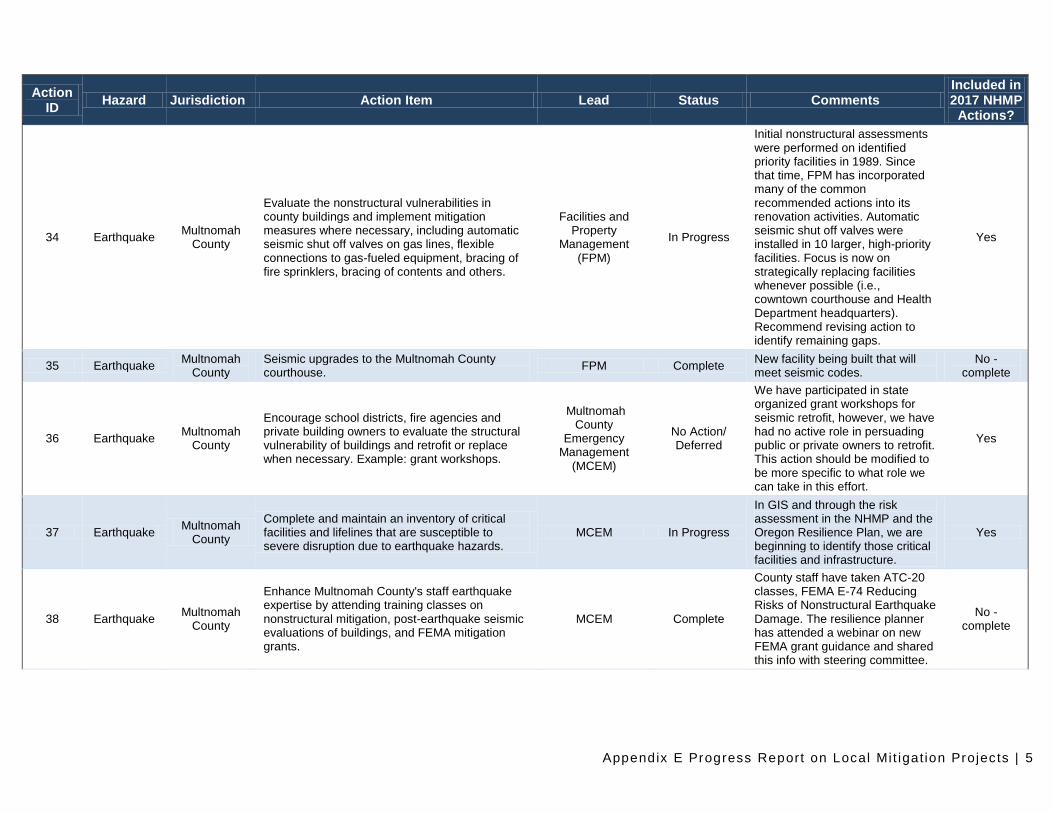
34 Earthquake Multnomah
County
Evaluate the nonstructural vulnerabilities in county buildings and implement mitigation measures where necessary, including automatic seismic shut off valves on gas lines, flexible connections to gas-fueled equipment, bracing of fire sprinklers, bracing of contents and others.
Facilities and Property
Management (FPM)
In Progress
Initial nonstructural assessments were performed on identified priority facilities in 1989. Since that time, FPM has incorporated many of the common recommended actions into its renovation activities. Automatic seismic shut off valves were installed in 10 larger, high-priority facilities. Focus is now on strategically replacing facilities whenever possible (i.e., cowntown courthouse and Health Department headquarters). Recommend revising action to identify remaining gaps.
Yes
35 Earthquake Multnomah
County Seismic upgrades to the Multnomah County courthouse.
FPM Complete New facility being built that will meet seismic codes.
No - complete
36 Earthquake Multnomah
County
Encourage school districts, fire agencies and private building owners to evaluate the structural vulnerability of buildings and retrofit or replace when necessary. Example: grant workshops.
Multnomah County
Emergency Management
(MCEM)
No Action/ Deferred
We have participated in state organized grant workshops for seismic retrofit, however, we have had no active role in persuading public or private owners to retrofit. This action should be modified to be more specific to what role we can take in this effort.
Yes
37 Earthquake Multnomah
County
Complete and maintain an inventory of critical facilities and lifelines that are susceptible to severe disruption due to earthquake hazards.
MCEM In Progress
In GIS and through the risk assessment in the NHMP and the Oregon Resilience Plan, we are beginning to identify those critical facilities and infrastructure.
Yes
38 Earthquake Multnomah
County
Enhance Multnomah County's staff earthquake expertise by attending training classes on nonstructural mitigation, post-earthquake seismic evaluations of buildings, and FEMA mitigation grants.
MCEM Complete
County staff have taken ATC-20 classes, FEMA E-74 Reducing Risks of Nonstructural Earthquake Damage. The resilience planner has attended a webinar on new FEMA grant guidance and shared this info with steering committee.
No - complete
Appendix E Progress Report on Local Mi t igat ion Projects | 6
Action ID
Hazard Jurisdiction Action Item Lead Status Comments Included in 2017 NHMP
Actions?
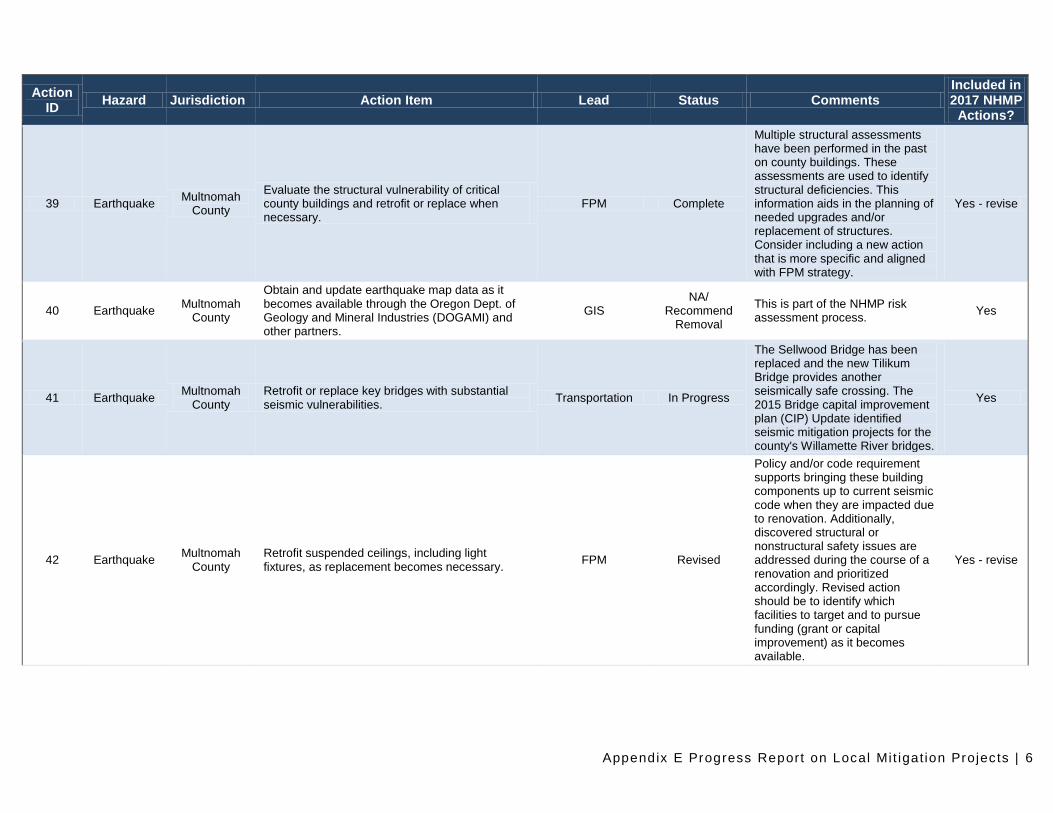
39 Earthquake Multnomah
County
Evaluate the structural vulnerability of critical county buildings and retrofit or replace when necessary.
FPM Complete
Multiple structural assessments have been performed in the past on county buildings. These assessments are used to identify structural deficiencies. This information aids in the planning of needed upgrades and/or replacement of structures. Consider including a new action that is more specific and aligned with FPM strategy.
Yes - revise
40 Earthquake Multnomah
County
Obtain and update earthquake map data as it becomes available through the Oregon Dept. of Geology and Mineral Industries (DOGAMI) and other partners.
GIS NA/
Recommend Removal
This is part of the NHMP risk assessment process.
Yes
41 Earthquake Multnomah
County Retrofit or replace key bridges with substantial seismic vulnerabilities.
Transportation In Progress
The Sellwood Bridge has been replaced and the new Tilikum Bridge provides another seismically safe crossing. The 2015 Bridge capital improvement plan (CIP) Update identified seismic mitigation projects for the county's Willamette River bridges.
Yes
42 Earthquake Multnomah
County Retrofit suspended ceilings, including light fixtures, as replacement becomes necessary.
FPM Revised
Policy and/or code requirement supports bringing these building components up to current seismic code when they are impacted due to renovation. Additionally, discovered structural or nonstructural safety issues are addressed during the course of a renovation and prioritized accordingly. Revised action should be to identify which facilities to target and to pursue funding (grant or capital improvement) as it becomes available.
Yes - revise
Appendix E Progress Report on Local Mi t igat ion Projects | 7
Action ID
Hazard Jurisdiction Action Item Lead Status Comments Included in 2017 NHMP
Actions?
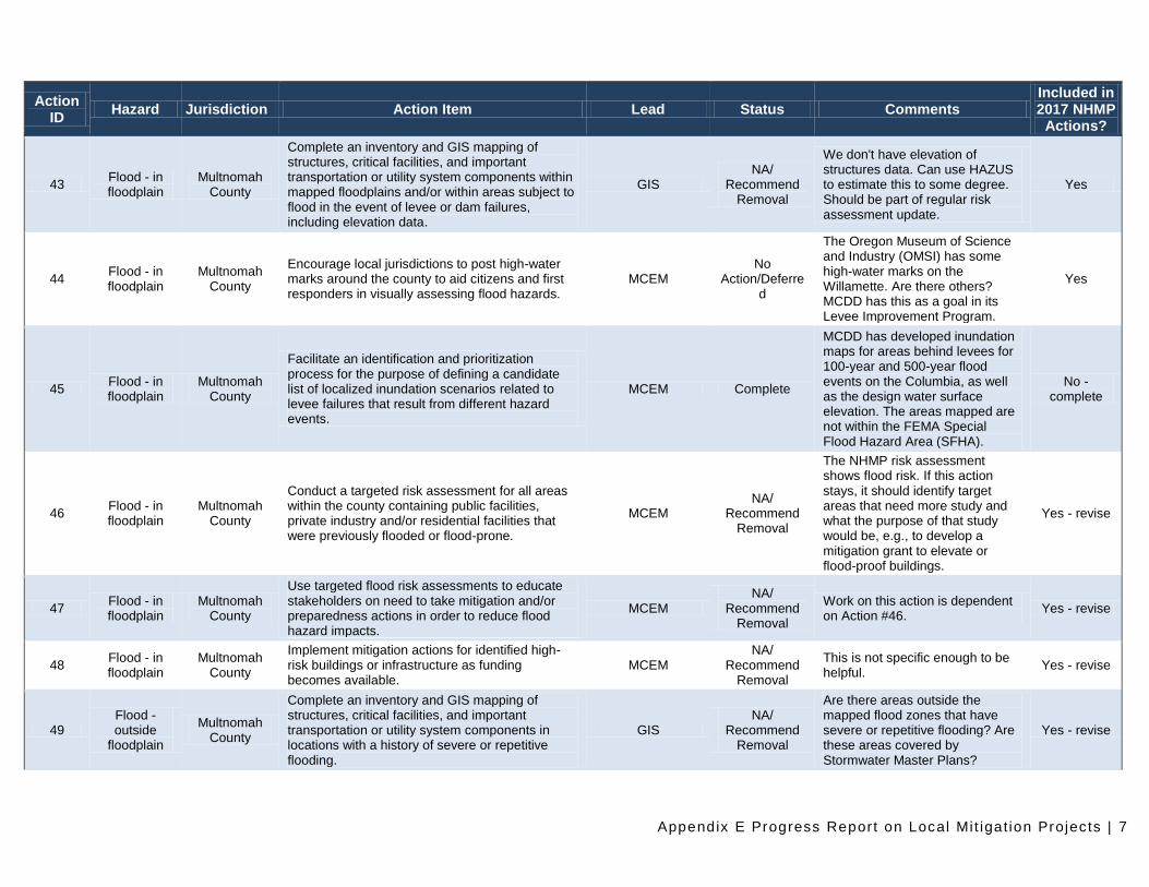
43 Flood - in floodplain
Multnomah County
Complete an inventory and GIS mapping of structures, critical facilities, and important transportation or utility system components within mapped floodplains and/or within areas subject to flood in the event of levee or dam failures, including elevation data.
GIS NA/
Recommend Removal
We don't have elevation of structures data. Can use HAZUS to estimate this to some degree. Should be part of regular risk assessment update.
Yes
44 Flood - in floodplain
Multnomah County
Encourage local jurisdictions to post high-water marks around the county to aid citizens and first responders in visually assessing flood hazards.
MCEM No
Action/Deferred
The Oregon Museum of Science and Industry (OMSI) has some high-water marks on the Willamette. Are there others? MCDD has this as a goal in its Levee Improvement Program.
Yes
45 Flood - in floodplain
Multnomah County
Facilitate an identification and prioritization process for the purpose of defining a candidate list of localized inundation scenarios related to levee failures that result from different hazard events.
MCEM Complete
MCDD has developed inundation maps for areas behind levees for 100-year and 500-year flood events on the Columbia, as well as the design water surface elevation. The areas mapped are not within the FEMA Special Flood Hazard Area (SFHA).
No - complete
46 Flood - in floodplain
Multnomah County
Conduct a targeted risk assessment for all areas within the county containing public facilities, private industry and/or residential facilities that were previously flooded or flood-prone.
MCEM NA/
Recommend Removal
The NHMP risk assessment shows flood risk. If this action stays, it should identify target areas that need more study and what the purpose of that study would be, e.g., to develop a mitigation grant to elevate or flood-proof buildings.
Yes - revise
47 Flood - in floodplain
Multnomah County
Use targeted flood risk assessments to educate stakeholders on need to take mitigation and/or preparedness actions in order to reduce flood hazard impacts.
MCEM NA/
Recommend Removal
Work on this action is dependent on Action #46.
Yes - revise
48 Flood - in floodplain
Multnomah County
Implement mitigation actions for identified high-risk buildings or infrastructure as funding becomes available.
MCEM NA/
Recommend Removal
This is not specific enough to be helpful.
Yes - revise
49 Flood - outside
floodplain
Multnomah County
Complete an inventory and GIS mapping of structures, critical facilities, and important transportation or utility system components in locations with a history of severe or repetitive flooding.
GIS NA/
Recommend Removal
Are there areas outside the mapped flood zones that have severe or repetitive flooding? Are these areas covered by Stormwater Master Plans?
Yes - revise
Appendix E Progress Report on Local Mi t igat ion Projects | 8
Action ID
Hazard Jurisdiction Action Item Lead Status Comments Included in 2017 NHMP
Actions?
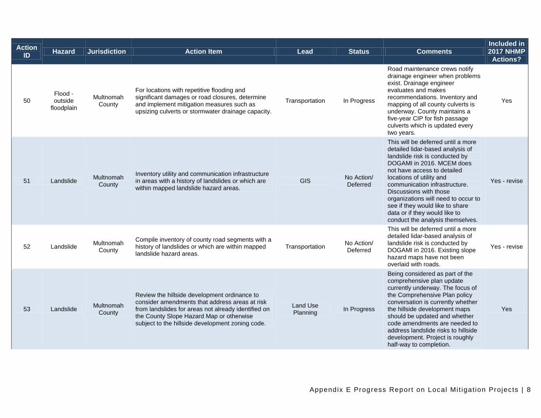
50 Flood - outside
floodplain
Multnomah County
For locations with repetitive flooding and significant damages or road closures, determine and implement mitigation measures such as upsizing culverts or stormwater drainage capacity.
Transportation In Progress
Road maintenance crews notify drainage engineer when problems exist. Drainage engineer evaluates and makes recommendations. Inventory and mapping of all county culverts is underway. County maintains a five-year CIP for fish passage culverts which is updated every two years.
Yes
51 Landslide Multnomah
County
Inventory utility and communication infrastructure in areas with a history of landslides or which are within mapped landslide hazard areas.
GIS No Action/ Deferred
This will be deferred until a more detailed lidar-based analysis of landslide risk is conducted by DOGAMI in 2016. MCEM does not have access to detailed locations of utility and communication infrastructure. Discussions with those organizations will need to occur to see if they would like to share data or if they would like to conduct the analysis themselves.
Yes - revise
52 Landslide Multnomah
County
Compile inventory of county road segments with a history of landslides or which are within mapped landslide hazard areas.
Transportation No Action/ Deferred
This will be deferred until a more detailed lidar-based analysis of landslide risk is conducted by DOGAMI in 2016. Existing slope hazard maps have not been overlaid with roads.
Yes - revise
53 Landslide Multnomah
County
Review the hillside development ordinance to consider amendments that address areas at risk from landslides for areas not already identified on the County Slope Hazard Map or otherwise subject to the hillside development zoning code.
Land Use Planning
In Progress
Being considered as part of the comprehensive plan update currently underway. The focus of the Comprehensive Plan policy conversation is currently whether the hillside development maps should be updated and whether code amendments are needed to address landslide risks to hillside development. Project is roughly half-way to completion.
Yes
Appendix E Progress Report on Local Mi t igat ion Projects | 9
Action ID
Hazard Jurisdiction Action Item Lead Status Comments Included in 2017 NHMP
Actions?
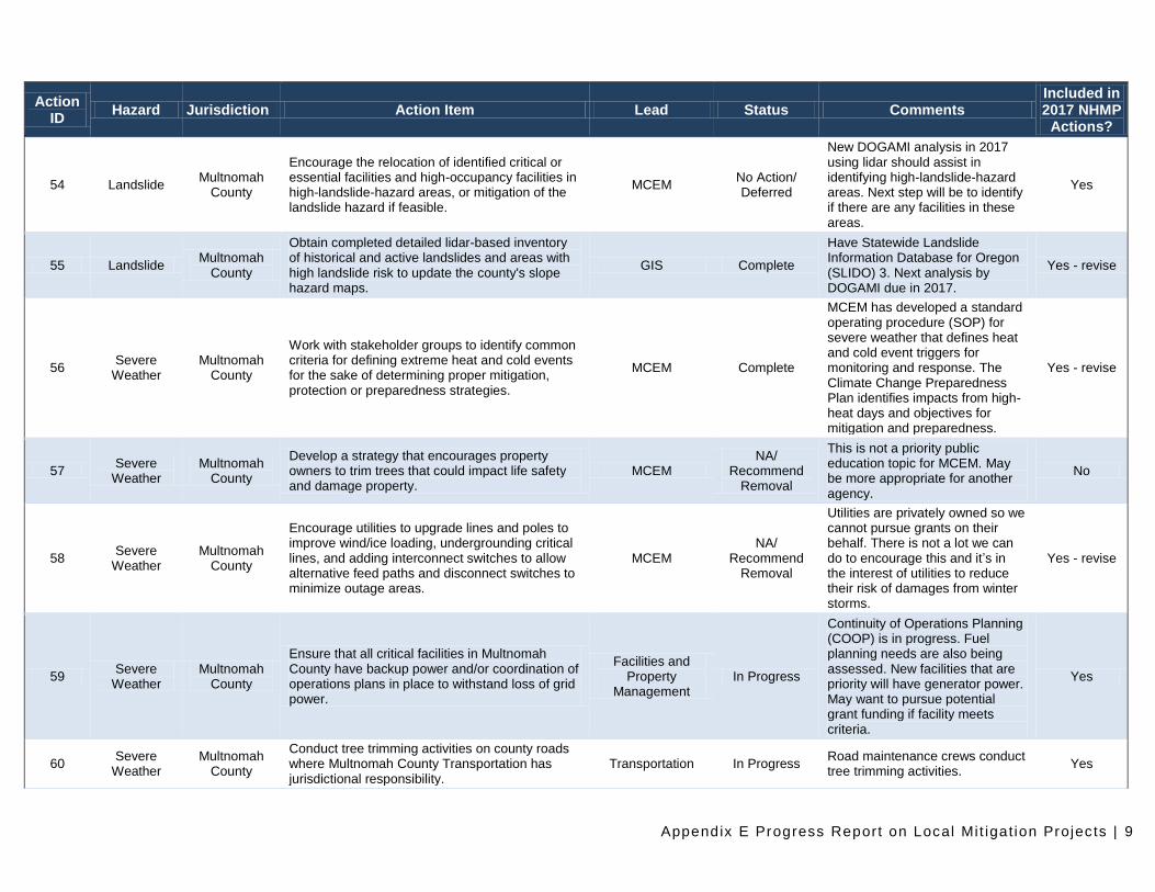
54 Landslide Multnomah
County
Encourage the relocation of identified critical or essential facilities and high-occupancy facilities in high-landslide-hazard areas, or mitigation of the landslide hazard if feasible.
MCEM No Action/ Deferred
New DOGAMI analysis in 2017 using lidar should assist in identifying high-landslide-hazard areas. Next step will be to identify if there are any facilities in these areas.
Yes
55 Landslide Multnomah
County
Obtain completed detailed lidar-based inventory of historical and active landslides and areas with high landslide risk to update the county's slope hazard maps.
GIS Complete
Have Statewide Landslide Information Database for Oregon (SLIDO) 3. Next analysis by DOGAMI due in 2017.
Yes - revise
56 Severe
Weather Multnomah
County
Work with stakeholder groups to identify common criteria for defining extreme heat and cold events for the sake of determining proper mitigation, protection or preparedness strategies.
MCEM Complete
MCEM has developed a standard operating procedure (SOP) for severe weather that defines heat and cold event triggers for monitoring and response. The Climate Change Preparedness Plan identifies impacts from high-heat days and objectives for mitigation and preparedness.
Yes - revise
57 Severe
Weather Multnomah
County
Develop a strategy that encourages property owners to trim trees that could impact life safety and damage property.
MCEM NA/
Recommend Removal
This is not a priority public education topic for MCEM. May be more appropriate for another agency.
No
58 Severe
Weather Multnomah
County
Encourage utilities to upgrade lines and poles to improve wind/ice loading, undergrounding critical lines, and adding interconnect switches to allow alternative feed paths and disconnect switches to minimize outage areas.
MCEM NA/
Recommend Removal
Utilities are privately owned so we cannot pursue grants on their behalf. There is not a lot we can do to encourage this and it’s in the interest of utilities to reduce their risk of damages from winter storms.
Yes - revise
59 Severe
Weather Multnomah
County
Ensure that all critical facilities in Multnomah County have backup power and/or coordination of operations plans in place to withstand loss of grid power.
Facilities and Property
Management In Progress
Continuity of Operations Planning (COOP) is in progress. Fuel planning needs are also being assessed. New facilities that are priority will have generator power. May want to pursue potential grant funding if facility meets criteria.
Yes
60 Severe
Weather Multnomah
County
Conduct tree trimming activities on county roads where Multnomah County Transportation has jurisdictional responsibility.
Transportation In Progress Road maintenance crews conduct tree trimming activities.
Yes
Appendix E Progress Report on Local Mi t igat ion Projects | 10
Action ID
Hazard Jurisdiction Action Item Lead Status Comments Included in 2017 NHMP
Actions?
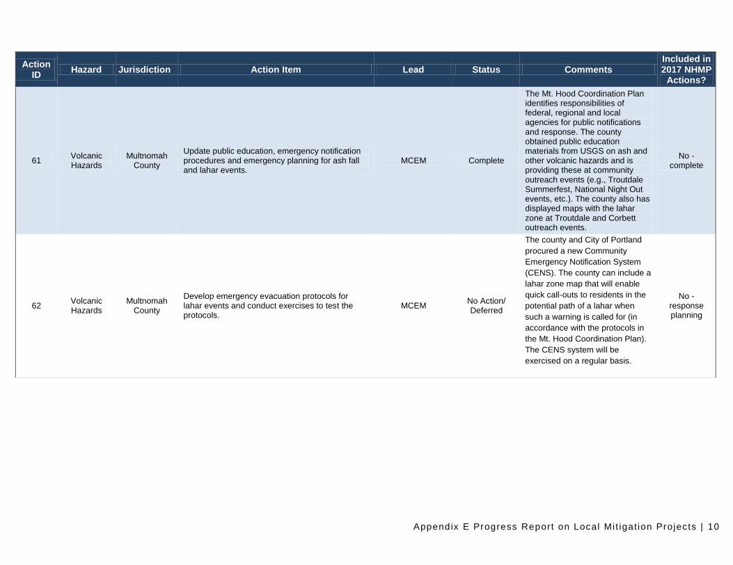
61 Volcanic Hazards
Multnomah County
Update public education, emergency notification procedures and emergency planning for ash fall and lahar events.
MCEM Complete
The Mt. Hood Coordination Plan identifies responsibilities of federal, regional and local agencies for public notifications and response. The county obtained public education materials from USGS on ash and other volcanic hazards and is providing these at community outreach events (e.g., Troutdale Summerfest, National Night Out events, etc.). The county also has displayed maps with the lahar zone at Troutdale and Corbett outreach events.
No - complete
62 Volcanic Hazards
Multnomah County
Develop emergency evacuation protocols for lahar events and conduct exercises to test the protocols.
MCEM No Action/ Deferred
The county and City of Portland
procured a new Community
Emergency Notification System
(CENS). The county can include a
lahar zone map that will enable
quick call-outs to residents in the
potential path of a lahar when
such a warning is called for (in
accordance with the protocols in
the Mt. Hood Coordination Plan).
The CENS system will be
exercised on a regular basis.
No - response planning
Appendix E Progress Report on Local Mi t igat ion Projects | 11
Action ID
Hazard Jurisdiction Action Item Lead Status Comments Included in 2017 NHMP
Actions?
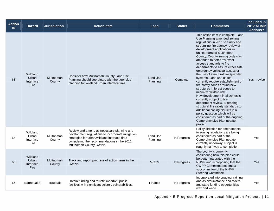
63
Wildland Urban
Interface Fire
Multnomah County
Consider how Multnomah County Land Use Planning should coordinate with fire agencies' planning for wildland urban interface fires.
Land Use Planning
Complete
This action item is complete. Land Use Planning amended zoning regulations in 2011 to clarify and streamline fire agency review of development applications in unincorporated Multnomah County. County zoning code was amended to defer review of access standards to fire departments to assure either safe emergency vehicular access or the use of structural fire sprinkler systems. Land use codes currently require establishment of fire safety zones around new structures in forest zones to minimize wildfire risk. New development in all zones is currently subject to fire department review. Extending structural fire safety standards to additional zoning districts is a policy question which will be considered as part of the ongoing Comprehensive Plan update project.
Yes - revise
64
Wildland Urban
Interface Fire
Multnomah County
Review and amend as necessary planning and development regulations to incorporate mitigation strategies for urban/wildland interface fires considering the recommendations in the 2011 Multnomah County CWPP.
Land Use Planning
In Progress
Policy direction for amendments to zoning regulations are being considered as part of the Comprehensive Plan update currently underway. Project is roughly half-way to completion.
Yes
65
Wildland Urban
Interface Fire
Multnomah County
Track and report progress of action items in the CWPP.
MCEM In Progress
The county is currently considering how this plan could be better integrated with the NHMP and is proposing that the CWPP Committee become a subcommittee of the NHMP Steering Committee.
Yes
66 Earthquake Troutdale Obtain funding and retrofit important public facilities with significant seismic vulnerabilities.
Finance In Progress
Incorporated into ongoing training, and as circumstance and federal and state funding opportunities wax and wane.
Yes
Appendix E Progress Report on Local Mi t igat ion Projects | 12
Action ID
Hazard Jurisdiction Action Item Lead Status Comments Included in 2017 NHMP
Actions?
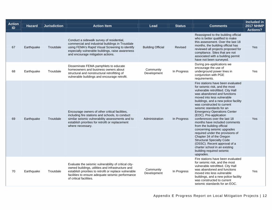
67 Earthquake Troutdale
Conduct a sidewalk survey of residential, commercial and industrial buildings in Troutdale using FEMA's Rapid Visual Screening to identify especially vulnerable buildings, raise awareness and encourage mitigation actions.
Building Official Revised
Reassigned to the building official who is better qualified to make this assessment. Over the last 18 months, the building official has reviewed all projects proposed for compliance. Sites that are not associated with a building permit have not been surveyed.
Yes
68 Earthquake Troutdale
Disseminate FEMA pamphlets to educate homeowners and business owners about structural and nonstructural retrofitting of vulnerable buildings and encourage retrofit.
Community Development
In Progress
During pre-applications we encourage the use of underground power lines in conjunction with PGE requirements.
Yes
69 Earthquake Troutdale
Encourage owners of other critical facilities, including fire stations and schools, to conduct similar seismic vulnerability assessments and to establish priorities for retrofit or replacement where necessary.
Administration In Progress
Fire stations have been evaluated for seismic risk, and the most vulnerable retrofitted. City Hall was abandoned and functions moved into less vulnerable buildings, and a new police facility was constructed to current seismic standards for an Emergency Operations Center (EOC). Pre-application conferences over the last 18 months have included comments from the building official concerning seismic upgrades required under the provisions of Chapter 34 of the Oregon Structural Specialty Code (OSSC). Recent approval of a charter school in an existing building required seismic upgrades.
Yes
70 Earthquake Troutdale
Evaluate the seismic vulnerability of critical city-owned buildings, utilities and infrastructure and establish priorities to retrofit or replace vulnerable facilities to ensure adequate seismic performance of critical facilities.
Community Development
In Progress
Fire stations have been evaluated for seismic risk, and the most vulnerable retrofitted. City Hall was abandoned and functions moved into less vulnerable buildings, and a new police facility was constructed to current seismic standards for an EOC.
Yes
Appendix E Progress Report on Local Mi t igat ion Projects | 13
Action ID
Hazard Jurisdiction Action Item Lead Status Comments Included in 2017 NHMP
Actions?
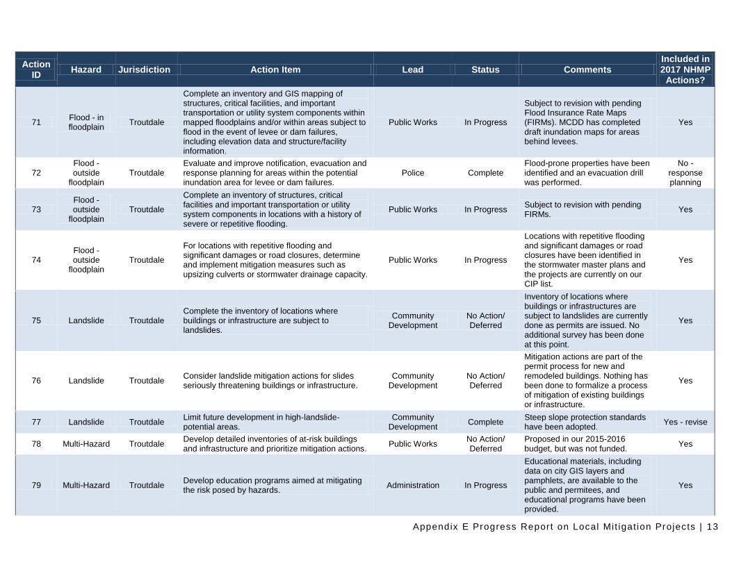
71 Flood - in floodplain
Troutdale
Complete an inventory and GIS mapping of structures, critical facilities, and important transportation or utility system components within mapped floodplains and/or within areas subject to flood in the event of levee or dam failures, including elevation data and structure/facility information.
Public Works In Progress
Subject to revision with pending Flood Insurance Rate Maps (FIRMs). MCDD has completed draft inundation maps for areas behind levees.
Yes
72 Flood - outside
floodplain Troutdale
Evaluate and improve notification, evacuation and response planning for areas within the potential inundation area for levee or dam failures.
Police Complete Flood-prone properties have been identified and an evacuation drill was performed.
No - response planning
73 Flood - outside
floodplain Troutdale
Complete an inventory of structures, critical facilities and important transportation or utility system components in locations with a history of severe or repetitive flooding.
Public Works In Progress Subject to revision with pending FIRMs.
Yes
74 Flood - outside
floodplain Troutdale
For locations with repetitive flooding and significant damages or road closures, determine and implement mitigation measures such as upsizing culverts or stormwater drainage capacity.
Public Works In Progress
Locations with repetitive flooding and significant damages or road closures have been identified in the stormwater master plans and the projects are currently on our CIP list.
Yes
75 Landslide Troutdale Complete the inventory of locations where buildings or infrastructure are subject to landslides.
Community Development
No Action/ Deferred
Inventory of locations where buildings or infrastructures are subject to landslides are currently done as permits are issued. No additional survey has been done at this point.
Yes
76 Landslide Troutdale Consider landslide mitigation actions for slides seriously threatening buildings or infrastructure.
Community Development
No Action/ Deferred
Mitigation actions are part of the permit process for new and remodeled buildings. Nothing has been done to formalize a process of mitigation of existing buildings or infrastructure.
Yes
77 Landslide Troutdale Limit future development in high-landslide-potential areas.
Community Development
Complete Steep slope protection standards have been adopted.
Yes - revise
78 Multi-Hazard Troutdale Develop detailed inventories of at-risk buildings and infrastructure and prioritize mitigation actions.
Public Works No Action/ Deferred
Proposed in our 2015-2016 budget, but was not funded.
Yes
79 Multi-Hazard Troutdale Develop education programs aimed at mitigating the risk posed by hazards.
Administration In Progress
Educational materials, including data on city GIS layers and pamphlets, are available to the public and permitees, and educational programs have been provided.
Yes
Appendix E Progress Report on Local Mi t igat ion Projects | 14
Action ID
Hazard Jurisdiction Action Item Lead Status Comments Included in 2017 NHMP
Actions?
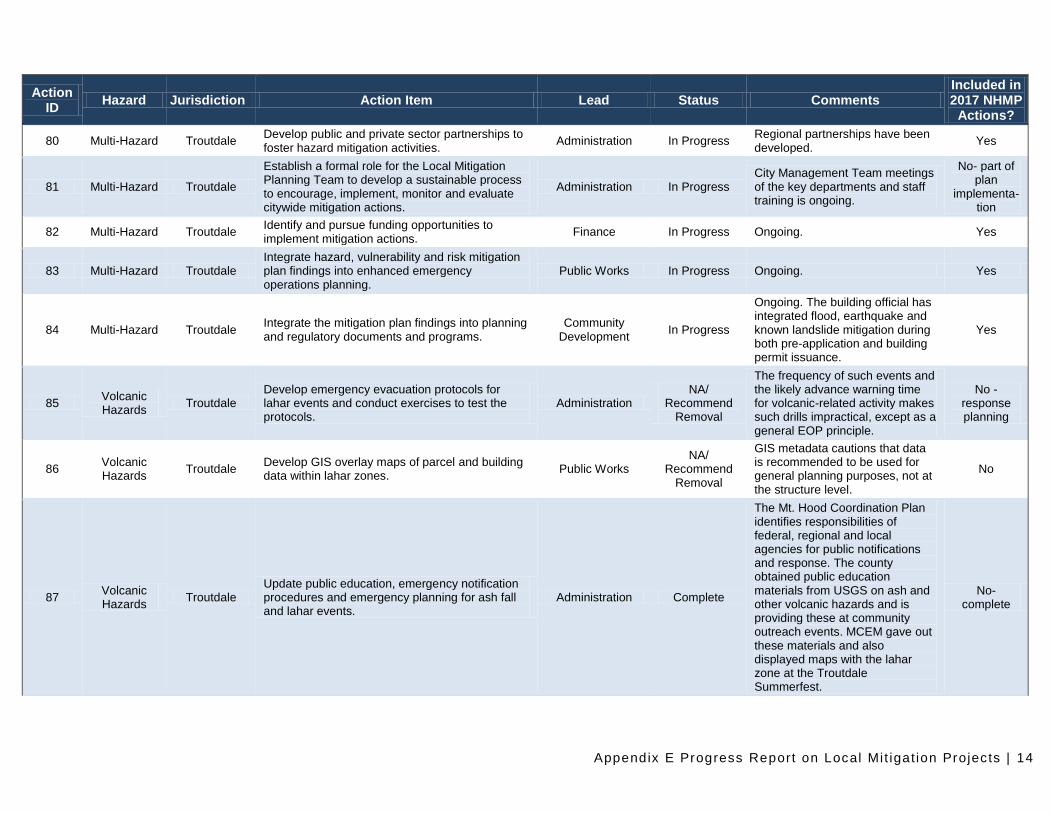
80 Multi-Hazard Troutdale Develop public and private sector partnerships to foster hazard mitigation activities.
Administration In Progress Regional partnerships have been developed.
Yes
81 Multi-Hazard Troutdale
Establish a formal role for the Local Mitigation Planning Team to develop a sustainable process to encourage, implement, monitor and evaluate citywide mitigation actions.
Administration In Progress City Management Team meetings of the key departments and staff training is ongoing.
No- part of plan
implementa-tion
82 Multi-Hazard Troutdale Identify and pursue funding opportunities to implement mitigation actions.
Finance In Progress Ongoing. Yes
83 Multi-Hazard Troutdale Integrate hazard, vulnerability and risk mitigation plan findings into enhanced emergency operations planning.
Public Works In Progress Ongoing. Yes
84 Multi-Hazard Troutdale Integrate the mitigation plan findings into planning and regulatory documents and programs.
Community Development
In Progress
Ongoing. The building official has integrated flood, earthquake and known landslide mitigation during both pre-application and building permit issuance.
Yes
85 Volcanic Hazards
Troutdale Develop emergency evacuation protocols for lahar events and conduct exercises to test the protocols.
Administration NA/
Recommend Removal
The frequency of such events and the likely advance warning time for volcanic-related activity makes such drills impractical, except as a general EOP principle.
No - response planning
86 Volcanic Hazards
Troutdale Develop GIS overlay maps of parcel and building data within lahar zones.
Public Works NA/
Recommend Removal
GIS metadata cautions that data is recommended to be used for general planning purposes, not at the structure level.
No
87 Volcanic Hazards
Troutdale Update public education, emergency notification procedures and emergency planning for ash fall and lahar events.
Administration Complete
The Mt. Hood Coordination Plan identifies responsibilities of federal, regional and local agencies for public notifications and response. The county obtained public education materials from USGS on ash and other volcanic hazards and is providing these at community outreach events. MCEM gave out these materials and also displayed maps with the lahar zone at the Troutdale Summerfest.
No- complete
Appendix E Progress Report on Local Mi t igat ion Projects | 15
Action ID
Hazard Jurisdiction Action Item Lead Status Comments Included in 2017 NHMP
Actions?
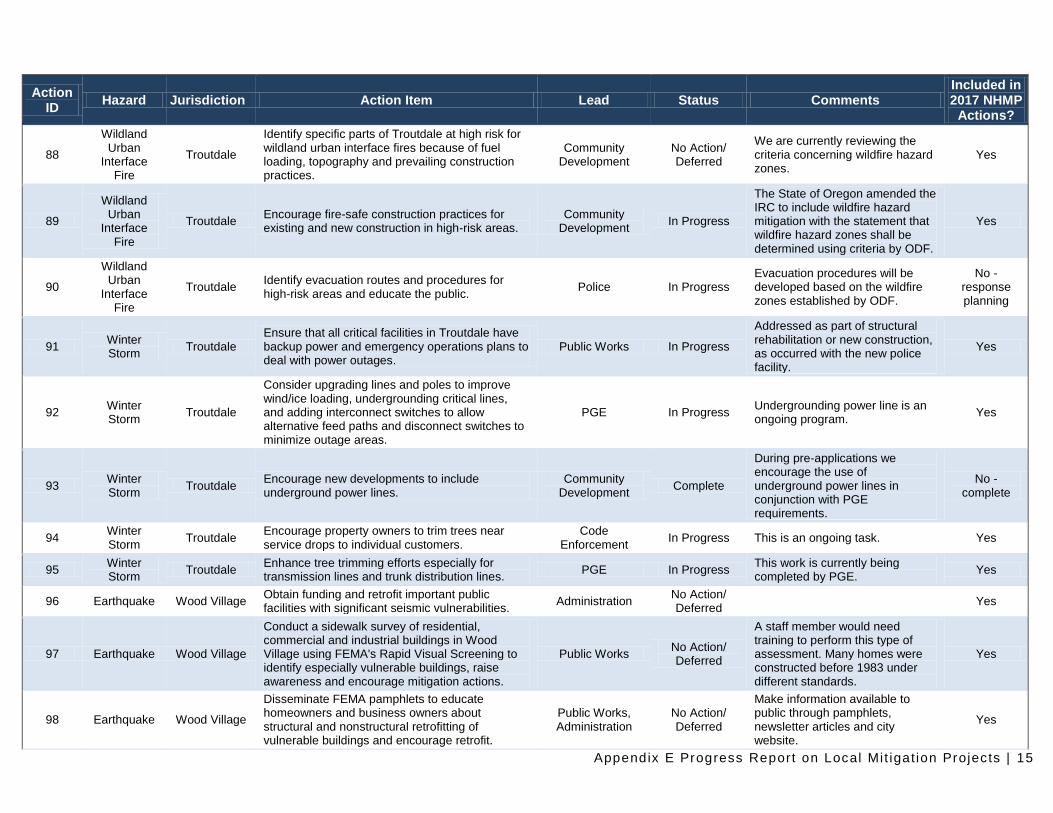
88
Wildland Urban
Interface Fire
Troutdale
Identify specific parts of Troutdale at high risk for wildland urban interface fires because of fuel loading, topography and prevailing construction practices.
Community Development
No Action/ Deferred
We are currently reviewing the criteria concerning wildfire hazard zones.
Yes
89
Wildland Urban
Interface Fire
Troutdale Encourage fire-safe construction practices for existing and new construction in high-risk areas.
Community Development
In Progress
The State of Oregon amended the IRC to include wildfire hazard mitigation with the statement that wildfire hazard zones shall be determined using criteria by ODF.
Yes
90
Wildland Urban
Interface Fire
Troutdale Identify evacuation routes and procedures for high-risk areas and educate the public.
Police In Progress Evacuation procedures will be developed based on the wildfire zones established by ODF.
No - response planning
91 Winter Storm
Troutdale Ensure that all critical facilities in Troutdale have backup power and emergency operations plans to deal with power outages.
Public Works In Progress
Addressed as part of structural rehabilitation or new construction, as occurred with the new police facility.
Yes
92 Winter Storm
Troutdale
Consider upgrading lines and poles to improve wind/ice loading, undergrounding critical lines, and adding interconnect switches to allow alternative feed paths and disconnect switches to minimize outage areas.
PGE In Progress Undergrounding power line is an ongoing program.
Yes
93 Winter Storm
Troutdale Encourage new developments to include underground power lines.
Community Development
Complete
During pre-applications we encourage the use of underground power lines in conjunction with PGE requirements.
No - complete
94 Winter Storm
Troutdale Encourage property owners to trim trees near service drops to individual customers.
Code Enforcement
In Progress This is an ongoing task. Yes
95 Winter Storm
Troutdale Enhance tree trimming efforts especially for transmission lines and trunk distribution lines.
PGE In Progress This work is currently being completed by PGE.
Yes
96 Earthquake Wood Village Obtain funding and retrofit important public facilities with significant seismic vulnerabilities.
Administration No Action/ Deferred
Yes
97 Earthquake Wood Village
Conduct a sidewalk survey of residential, commercial and industrial buildings in Wood Village using FEMA's Rapid Visual Screening to identify especially vulnerable buildings, raise awareness and encourage mitigation actions.
Public Works No Action/ Deferred
A staff member would need training to perform this type of assessment. Many homes were constructed before 1983 under different standards.
Yes
98 Earthquake Wood Village
Disseminate FEMA pamphlets to educate homeowners and business owners about structural and nonstructural retrofitting of vulnerable buildings and encourage retrofit.
Public Works, Administration
No Action/ Deferred
Make information available to public through pamphlets, newsletter articles and city website.
Yes
Appendix E Progress Report on Local Mi t igat ion Projects | 16
Action ID
Hazard Jurisdiction Action Item Lead Status Comments Included in 2017 NHMP
Actions?
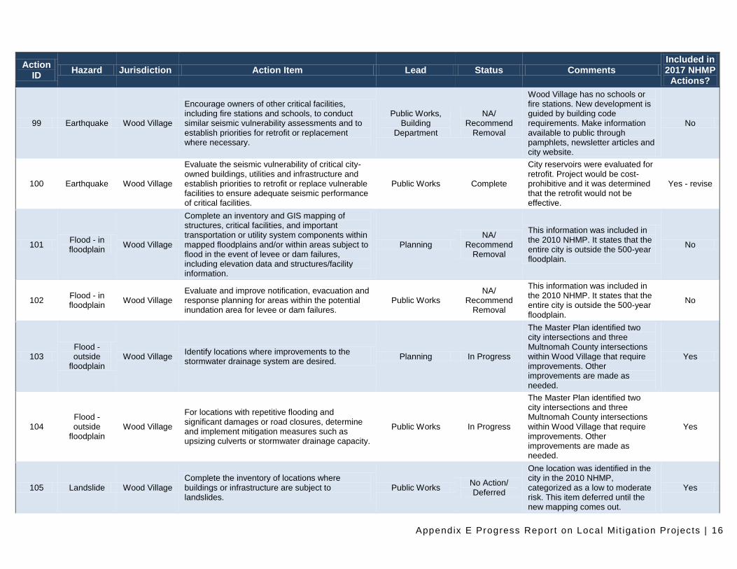
99 Earthquake Wood Village
Encourage owners of other critical facilities, including fire stations and schools, to conduct similar seismic vulnerability assessments and to establish priorities for retrofit or replacement where necessary.
Public Works, Building
Department
NA/ Recommend
Removal
Wood Village has no schools or fire stations. New development is guided by building code requirements. Make information available to public through pamphlets, newsletter articles and city website.
No
100 Earthquake Wood Village
Evaluate the seismic vulnerability of critical city-owned buildings, utilities and infrastructure and establish priorities to retrofit or replace vulnerable facilities to ensure adequate seismic performance of critical facilities.
Public Works Complete
City reservoirs were evaluated for retrofit. Project would be cost-prohibitive and it was determined that the retrofit would not be effective.
Yes - revise
101 Flood - in floodplain
Wood Village
Complete an inventory and GIS mapping of structures, critical facilities, and important transportation or utility system components within mapped floodplains and/or within areas subject to flood in the event of levee or dam failures, including elevation data and structures/facility information.
Planning NA/
Recommend Removal
This information was included in the 2010 NHMP. It states that the entire city is outside the 500-year floodplain.
No
102 Flood - in floodplain
Wood Village Evaluate and improve notification, evacuation and response planning for areas within the potential inundation area for levee or dam failures.
Public Works NA/
Recommend Removal
This information was included in the 2010 NHMP. It states that the entire city is outside the 500-year floodplain.
No
103 Flood - outside
floodplain Wood Village
Identify locations where improvements to the stormwater drainage system are desired.
Planning In Progress
The Master Plan identified two city intersections and three Multnomah County intersections within Wood Village that require improvements. Other improvements are made as needed.
Yes
104 Flood - outside
floodplain Wood Village
For locations with repetitive flooding and significant damages or road closures, determine and implement mitigation measures such as upsizing culverts or stormwater drainage capacity.
Public Works In Progress
The Master Plan identified two city intersections and three Multnomah County intersections within Wood Village that require improvements. Other improvements are made as needed.
Yes
105 Landslide Wood Village Complete the inventory of locations where buildings or infrastructure are subject to landslides.
Public Works No Action/ Deferred
One location was identified in the city in the 2010 NHMP, categorized as a low to moderate risk. This item deferred until the new mapping comes out.
Yes
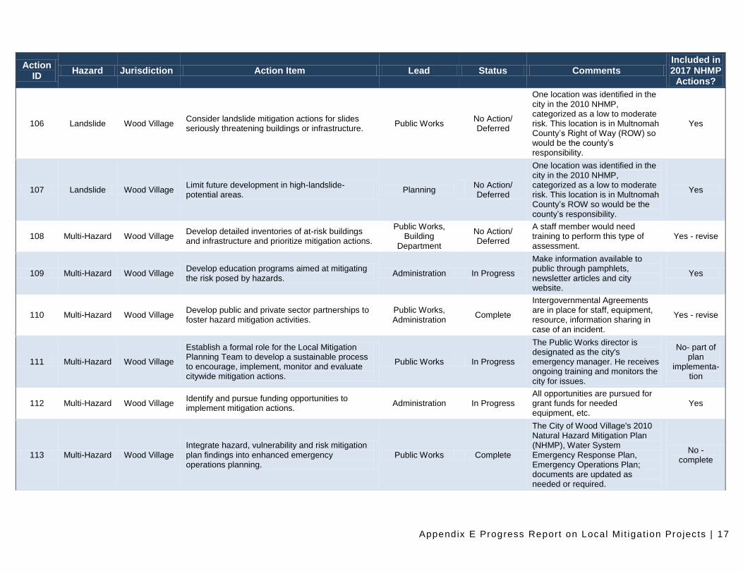
Appendix E Progress Report on Local Mi t igat ion Projects | 17
Action ID
Hazard Jurisdiction Action Item Lead Status Comments Included in 2017 NHMP
Actions?
106 Landslide Wood Village Consider landslide mitigation actions for slides seriously threatening buildings or infrastructure.
Public Works No Action/ Deferred
One location was identified in the city in the 2010 NHMP, categorized as a low to moderate risk. This location is in Multnomah County’s Right of Way (ROW) so would be the county’s responsibility.
Yes
107 Landslide Wood Village Limit future development in high-landslide-potential areas.
Planning No Action/ Deferred
One location was identified in the city in the 2010 NHMP, categorized as a low to moderate risk. This location is in Multnomah County’s ROW so would be the county’s responsibility.
Yes
108 Multi-Hazard Wood Village Develop detailed inventories of at-risk buildings and infrastructure and prioritize mitigation actions.
Public Works, Building
Department
No Action/ Deferred
A staff member would need training to perform this type of assessment.
Yes - revise
109 Multi-Hazard Wood Village Develop education programs aimed at mitigating the risk posed by hazards.
Administration In Progress
Make information available to public through pamphlets, newsletter articles and city website.
Yes
110 Multi-Hazard Wood Village Develop public and private sector partnerships to foster hazard mitigation activities.
Public Works, Administration
Complete
Intergovernmental Agreements are in place for staff, equipment, resource, information sharing in case of an incident.
Yes - revise
111 Multi-Hazard Wood Village
Establish a formal role for the Local Mitigation Planning Team to develop a sustainable process to encourage, implement, monitor and evaluate citywide mitigation actions.
Public Works In Progress
The Public Works director is designated as the city's emergency manager. He receives ongoing training and monitors the city for issues.
No- part of plan
implementa-tion
112 Multi-Hazard Wood Village Identify and pursue funding opportunities to implement mitigation actions.
Administration In Progress All opportunities are pursued for grant funds for needed equipment, etc.
Yes
113 Multi-Hazard Wood Village Integrate hazard, vulnerability and risk mitigation plan findings into enhanced emergency operations planning.
Public Works Complete
The City of Wood Village's 2010 Natural Hazard Mitigation Plan (NHMP), Water System Emergency Response Plan, Emergency Operations Plan; documents are updated as needed or required.
No - complete
Appendix E Progress Report on Local Mi t igat ion Projects | 18
Action ID
Hazard Jurisdiction Action Item Lead Status Comments Included in 2017 NHMP
Actions?
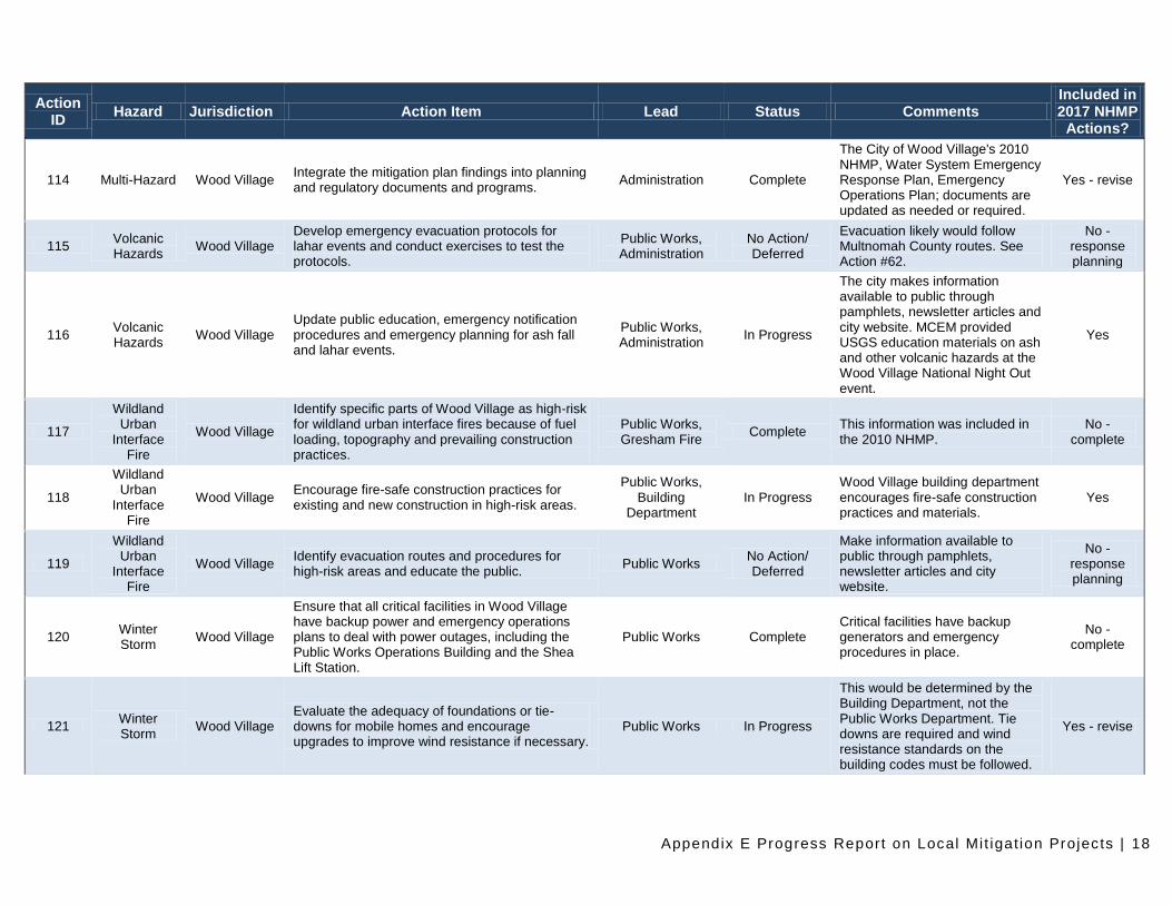
114 Multi-Hazard Wood Village Integrate the mitigation plan findings into planning and regulatory documents and programs.
Administration Complete
The City of Wood Village's 2010 NHMP, Water System Emergency Response Plan, Emergency Operations Plan; documents are updated as needed or required.
Yes - revise
115 Volcanic Hazards
Wood Village Develop emergency evacuation protocols for lahar events and conduct exercises to test the protocols.
Public Works, Administration
No Action/ Deferred
Evacuation likely would follow Multnomah County routes. See Action #62.
No - response planning
116 Volcanic Hazards
Wood Village Update public education, emergency notification procedures and emergency planning for ash fall and lahar events.
Public Works, Administration
In Progress
The city makes information available to public through pamphlets, newsletter articles and city website. MCEM provided USGS education materials on ash and other volcanic hazards at the Wood Village National Night Out event.
Yes
117
Wildland Urban
Interface Fire
Wood Village
Identify specific parts of Wood Village as high-risk for wildland urban interface fires because of fuel loading, topography and prevailing construction practices.
Public Works, Gresham Fire
Complete This information was included in the 2010 NHMP.
No - complete
118
Wildland Urban
Interface Fire
Wood Village Encourage fire-safe construction practices for existing and new construction in high-risk areas.
Public Works, Building
Department In Progress
Wood Village building department encourages fire-safe construction practices and materials.
Yes
119
Wildland Urban
Interface Fire
Wood Village Identify evacuation routes and procedures for high-risk areas and educate the public.
Public Works No Action/ Deferred
Make information available to public through pamphlets, newsletter articles and city website.
No - response planning
120 Winter Storm
Wood Village
Ensure that all critical facilities in Wood Village have backup power and emergency operations plans to deal with power outages, including the Public Works Operations Building and the Shea Lift Station.
Public Works Complete Critical facilities have backup generators and emergency procedures in place.
No - complete
121 Winter Storm
Wood Village Evaluate the adequacy of foundations or tie-downs for mobile homes and encourage upgrades to improve wind resistance if necessary.
Public Works In Progress
This would be determined by the Building Department, not the Public Works Department. Tie downs are required and wind resistance standards on the building codes must be followed.
Yes - revise
Appendix E Progress Report on Local Mi t igat ion Projects | 19
Action ID
Hazard Jurisdiction Action Item Lead Status Comments Included in 2017 NHMP
Actions?
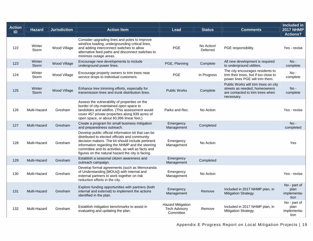
122 Winter Storm
Wood Village
Consider upgrading lines and poles to improve wind/ice loading, undergrounding critical lines, and adding interconnect switches to allow alternative feed paths and disconnect switches to minimize outage areas.
PGE No Action/ Deferred
PGE responsibility. Yes - revise
123 Winter Storm
Wood Village Encourage new developments to include underground power lines.
PGE, Planning Complete All new development is required to underground utilities.
No - complete
124 Winter Storm
Wood Village Encourage property owners to trim trees near service drops to individual customers.
PGE In Progress The city encourages residents to trim their trees, but if too close to power lines PGE will trim them.
No - complete
125 Winter Storm
Wood Village Enhance tree trimming efforts, especially for transmission lines and trunk distribution lines.
Public Works Complete
Public Works will trim trees on city streets as needed; homeowners are contacted to trim trees when necessary.
No - complete
126 Multi-Hazard Gresham
Assess the vulnerability of properties on the border of city-maintained open space to landslides and wildfire. (This assessment would cover 457 private properties along 839 acres of open space, or about 60,996 linear feet.)
Parks and Rec. No Action Yes - revise
127 Multi-Hazard Gresham Create a program for small business mitigation and preparedness outreach.
Emergency Management
Completed No -
completed
128 Multi-Hazard Gresham
Develop public official information kit that can be distributed to elected officials and community decision makers. The kit should include pertinent information regarding the NHMP and the steering committee and its activities, as well as facts and figures on the natural hazard the city is facing.
Emergency Management
No Action Yes
129 Multi-Hazard Gresham Establish a seasonal citizen awareness and outreach campaign.
Emergency Management
Completed
130 Multi-Hazard Gresham
Develop formal agreements (such as Memoranda of Understanding [MOUs]) with internal and external partners to work together on risk reduction efforts in the city.
Emergency Management
No Action Yes - revise
131 Multi-Hazard Gresham Explore funding opportunities with partners (both internal and external) to implement the actions identified in the plan.
Emergency Management
Remove Included in 2017 NHMP plan, in Mitigation Strategy.
No - part of plan
implementa-tion
132 Multi-Hazard Gresham Establish mitigation benchmarks to assist in evaluating and updating the plan.
Hazard Mitigation Tech Advisory
Committee Remove
Included in 2017 NHMP plan, in Mitigation Strategy.
No - part of plan
implementa-tion
Appendix E Progress Report on Local Mi t igat ion Projects | 20
Action ID
Hazard Jurisdiction Action Item Lead Status Comments Included in 2017 NHMP
Actions?
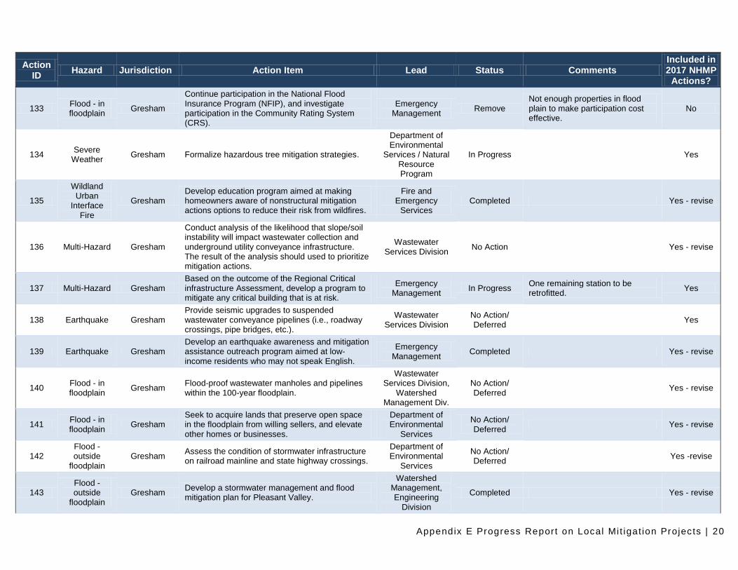
133 Flood - in floodplain
Gresham
Continue participation in the National Flood Insurance Program (NFIP), and investigate participation in the Community Rating System (CRS).
Emergency Management
Remove Not enough properties in flood plain to make participation cost effective.
No
134 Severe
Weather Gresham Formalize hazardous tree mitigation strategies.
Department of Environmental
Services / Natural Resource Program
In Progress Yes
135
Wildland Urban
Interface Fire
Gresham Develop education program aimed at making homeowners aware of nonstructural mitigation actions options to reduce their risk from wildfires.
Fire and Emergency
Services Completed Yes - revise
136 Multi-Hazard Gresham
Conduct analysis of the likelihood that slope/soil instability will impact wastewater collection and underground utility conveyance infrastructure. The result of the analysis should used to prioritize mitigation actions.
Wastewater Services Division
No Action Yes - revise
137 Multi-Hazard Gresham Based on the outcome of the Regional Critical infrastructure Assessment, develop a program to mitigate any critical building that is at risk.
Emergency Management
In Progress One remaining station to be retrofitted.
Yes
138 Earthquake Gresham Provide seismic upgrades to suspended wastewater conveyance pipelines (i.e., roadway crossings, pipe bridges, etc.).
Wastewater Services Division
No Action/ Deferred
Yes
139 Earthquake Gresham Develop an earthquake awareness and mitigation assistance outreach program aimed at low-income residents who may not speak English.
Emergency Management
Completed Yes - revise
140 Flood - in floodplain
Gresham Flood-proof wastewater manholes and pipelines within the 100-year floodplain.
Wastewater Services Division,
Watershed Management Div.
No Action/ Deferred
Yes - revise
141 Flood - in floodplain
Gresham Seek to acquire lands that preserve open space in the floodplain from willing sellers, and elevate other homes or businesses.
Department of Environmental
Services
No Action/ Deferred
Yes - revise
142 Flood - outside
floodplain Gresham
Assess the condition of stormwater infrastructure on railroad mainline and state highway crossings.
Department of Environmental
Services
No Action/ Deferred
Yes -revise
143 Flood - outside
floodplain Gresham
Develop a stormwater management and flood mitigation plan for Pleasant Valley.
Watershed Management, Engineering
Division
Completed Yes - revise
Appendix E Progress Report on Local Mi t igat ion Projects | 21
Action ID
Hazard Jurisdiction Action Item Lead Status Comments Included in 2017 NHMP
Actions?
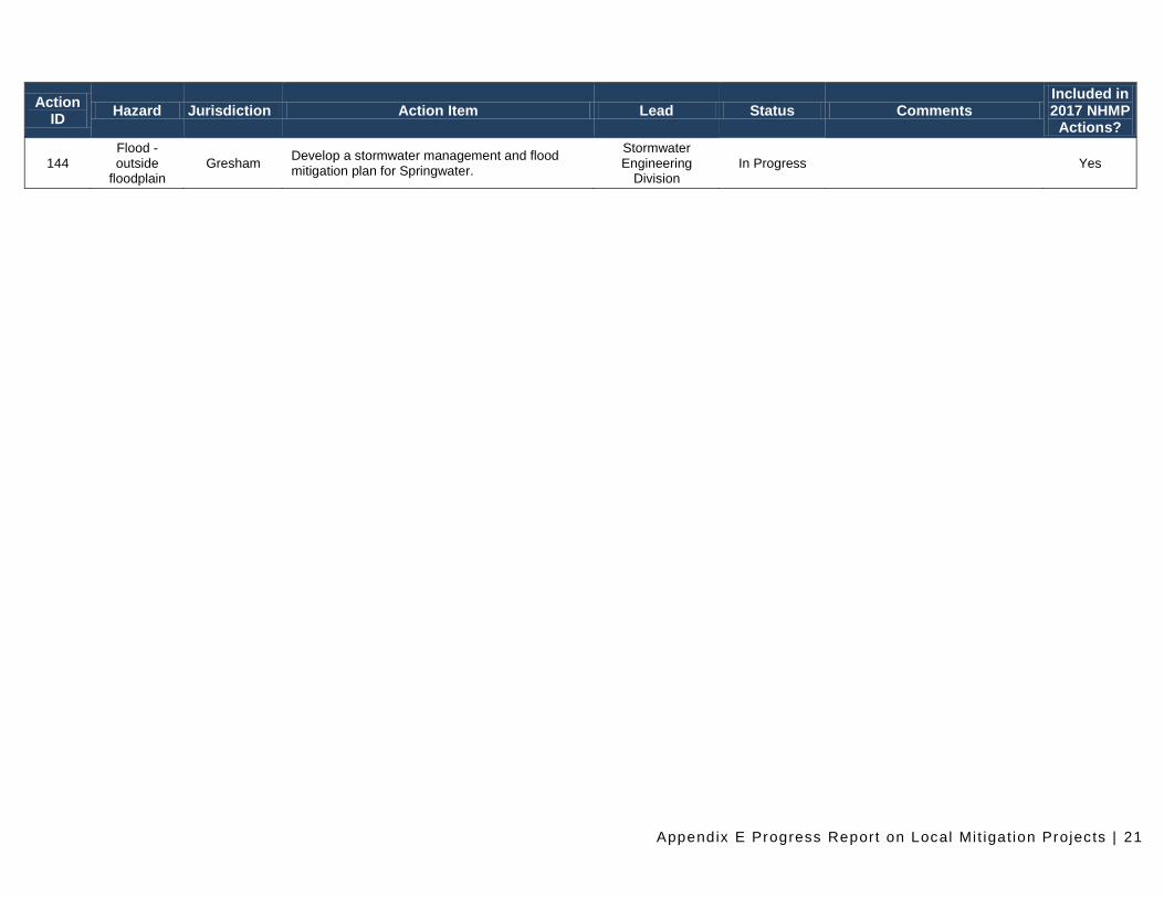
144 Flood - outside
floodplain Gresham
Develop a stormwater management and flood mitigation plan for Springwater.
Stormwater Engineering
Division In Progress Yes