appendix f. outreach and scoping - state of · pdf filemiriam chion regional ... port of...
TRANSCRIPT

Appendix F. Outreach and Scoping


SAN FRANCISCO TO SAN JOSE SECTION CALIFORNIA HIGH-SPEED TRAIN PROJECT EIR/EIS APPENDIX F – OUTREACH AND SCOPING
U.S. Department of Transportation Page F-1 Federal Railroad Administration
Summary of Agency Coordination and Public Outreach Efforts This document presents a summary of agency coordination and public outreach activities that have informed the development of the Alternatives Analysis. It describes the activities and meetings that have occurred in chronological order, and summarizes the comments received at each meeting.
Overview
Broad agency and public coordination is encouraged during the EIR/EIS scoping period and review of the draft environmental documents. To advance this process, the Authority invited comments from all interested agencies to facilitate discussions on issues related to the proposed alternatives, areas of environmental sensitivity and any circumstance where there’s the potential for significant impacts from the High-Speed Train (HST) project. Initial outreach activities were conducted with key decision makers, agency representatives, businesses, environmental groups and community leadership throughout the San Francisco to San Jose project corridor beginning in November 2008 and continued through mid-January 2009. As the scoping period began, three meetings were held between January 22 and January 29, 2009 in San Francisco, San Mateo and Santa Clara counties. In an effort to provide additional opportunities for agency and public input, various briefings and three project information meetings were also held in Millbrae, Redwood City and Palo Alto between February and March 2009.
Using input from the scoping process, the regional team developed the initial range of alternatives for the San Francisco to San Jose section was developed. Since the horizontal alignment was determined through the Bay Area Program EIR/EIS, the initial alternatives focused on potential vertical options within the Caltrain Corridor. In July 2009, the initial alternatives were reviewed with the CHSRA and the FRA. In September and October 2009, the San Francisco to San Jose alternatives were presented to the Technical Working Groups and Policy Working Group, who provided input on the alternatives to be studied and information about city and county land use and planning (see Section 3.3.2 and Appendix J for detail of outreach activities). In addition, three public workshops were held, and the San Francisco to San Jose project team met with the staff of each City along the corridor to review the options presented. This initial review of alternatives defined the range of alternatives that would be carried forward into the alternatives analysis process. The preliminary results of the evaluation were reviewed at a workshop with the Authority and the FRA in November 2009.
Early Outreach and Scoping
A program of pre-scoping public outreach activities were initiated in December 2008, including the development of project information materials, establishment of a project information telephone line, early engagement with interested parties, and media communications. On December 22, 2008, a Notice of Preparation (NOP) announcing the preparation of the EIR was distributed to the State Clearinghouse; elected officials (federal, regional, local), and federal, state, and local agencies, including planning and community development directors (in San Francisco, San Mateo and Santa Clara counties). A Notice of Intent (NOI) announcing the preparation of the EIS was published in the Federal Register on December 29, 2008. A revised NOP was transmitted to the State of California, Governor’s Office of Planning and Research (State Clearinghouse and Planning Unit) on January 8, 2009 to clarify that the end of the comment period was March 6, 2009. On February 17, 2009 the Authority extended the comment period to April 6, 2009 (an additional 30 days), based on a request from the City of Palo Alto, CA. During the scoping period, three public scoping meetings were held between January 22 and January 29, 2009, in San Francisco, San Mateo and Santa Clara and three information meetings were held at the proposed/potential HST station locations of Millbrae, Redwood
City and Palo Alto. In addition, a number of briefings and project information meetings were held. Detailed information about the scoping (and other coordination meetings) is documented in the draft San Francisco to San Jose Scoping Report (June 2009 and updated in August 2009).
Technical Working Groups – Meeting #1
To enhance outreach and coordination efforts related to the assessment of the proposed alternatives (and other municipal, land use and planning, and regulatory/permitting considerations) a Technical Working Group (TWG) process was established in spring-2009. The initial series of Technical Working Group meetings with the city/county and transportation agency representatives was held on June 23, 2009 (in San Carlos) and the resource agency representatives meeting was held on June 26, 2009 (in San Francisco). See Tables 1-3 for a listing of the TWG members. These meetings provided an overview of the San Francisco to San Jose section environmental process, created a forum for early engagement around alternatives options and underscored the need for ongoing collaboration between the designated resource, city/county and transportation agency representatives, as well as the project technical and outreach staff. The meetings focused on the role of the TWG in assessing technical information provided by the project team, providing assistance with coordination pertaining to land use planning, identifying potential physical and environmental impacts to existing assets, identification (and recommendations related to mitigation) of potential community impacts and current conceptual alternatives options.

SAN FRANCISCO TO SAN JOSE SECTION CALIFORNIA HIGH-SPEED TRAIN PROJECT EIR/EIS APPENDIX F – OUTREACH AND SCOPING
U.S. Department of Transportation Page F-2 Federal Railroad Administration
Table 1 Technical Working Group – Transportation Agencies Agency Contact Title
BART Thomas Tumola Senior Planner
JPB/SamTrans Hilda Lafebre Environmental Manager
San Francisco Bay Area Water Emergency Transportation Authority
John Sindzinski Planning and Development Manager
Santa Clara Valley Transportation Authority Steve Fisher Senior Transportation Planner
Amtrak Jonathan Hutchison Director of Governmental Affairs
Capitol Corridor Joint Powers Authority David Kutrosky Deputy Managing Director
Altamont Commuter Express Brian Schmidt Director of Planning & Programming
SF Bay Rail Jacob Park Vice President
AC Transit Robert Del Rosario Senior Transportation Planner
TJPA Brian Dykes Principal Engineer
Metropolitan Transportation Commission Ashley Nguyen Senior Transportation Planner
San Francisco International Airport Julian Potter Fed. Regional Governmental Affairs Mgr
Federal Highway Administration (FHWA), CA Division David Cohen Environmental Program Coordinator
Federal Highway Administration (FHWA), CA Division Shawn Oliver State Programs Team Leader
Federal Aviation Administration Richard Dykas Regional Capacity Officer
Federal Transit Administration, Region IX Eric Eidlin Community Planner
California Department of Transportation, District 4 Becky Frank Senior Transportation Planner
California Department of Transportation, District 4 Ron Moriguchi Regional Project Manager
San Francisco County Transportation Authority Lee Saage Project Manager
Table 2 Technical Working Group – Resource Agencies Agency Contact Title
US and CA EPA Region 9 Carolyn Mulvihill Environmental Protection Specialist
California Public Utilities Commission Daniel Kevin Railroad Operations Safety Branch
U.S. Homeland Security, 11th Coast Guard District
Carl Hausner Bridge Management Specialist
Bay Area Air Quality Management District Michael Murphy Advanced Projects Advisor
US Army Corps of Engineers(SF) Bob Smith Senior Biologist State Water Resource Control Board Brian Wines Water Resources Control
Engineer
US Fish & Wildlife Service Kathy Wood Assistant Field Supervisor Department of Toxic Substance Control Andrew Berna-Hicks Chief, Brownfields &
Environmental Restoration Program
Department of Toxic Substance Control Mark Piros Unit Chief, Brownfields & Environmental Restoration Program
Santa Clara Valley Water District Usha Chatwani Associate Civil Engineer San Mateo County Flood Control District Mark Chow Principal Engineer

SAN FRANCISCO TO SAN JOSE SECTION CALIFORNIA HIGH-SPEED TRAIN PROJECT EIR/EIS APPENDIX F – OUTREACH AND SCOPING
U.S. Department of Transportation Page F-3 Federal Railroad Administration
Table 3 Technical Working Group – City and County Agencies Agency Contact Title
City and County of Associated Governments (C/CAG)
Richard Napier Executive Director
City and County of San Francisco, Planning Department
Viktoriya Wise Senior Planner
City and County of San Francisco Redevelopment
Mike Grisso Senior Project Manager
City and County of San Francisco, Office of Economic and Workforce
Michael Cohen Director
City of Belmont Karen Borrmann Interim Public Works Dir.
City of Belmont Carlos De Melo Community Development Dir.
City of Brisbane John Swiecki Principal Planner
City of Burlingame Art Morimoto Asst. Director of Public Works
City of Menlo Park Kent Steffens Director of Public Works
City of Millbrae Ron Popp Director of Public Works
City of Mountain View Joan Jenkins Transportation Policy Manager
City of Mountain View Helen Kim Project Manager
City of Palo Alto Shahla Yazdy Transportation Engineer
City of Palo Alto Steve Emslie Deputy City Manager
City of Redwood City Chu Chang Director, Building, Infrastructure and Transportation Department
City of San Bruno Klara Fabry Public Service Director
City of San Carlos Robert Weil Director of Public Works
City of San Jose Ben Tripousis Transportation Systems Manager
City of San Jose Henry Servin Rail Project Liaison Manager
City of San Mateo Larry Patterson Director of Public Works
City of Santa Clara Payal Bhagat Assitant Planner II
Agency Contact Title City of Santa Clara Debby Fernandez Associate Planner City of Santa Clara Rajeev Batra Director of Public Works
City of Santa Clara Dennis Ng Traffic Engineer City of Santa Clara Gustavo Gomez Principal Engineer, Land & Property
Development Division
City of South San Francisco Ray Razavi City Engineer City of South San Francisco Susy Kalkin Chief Planner City of Sunnyvale Jack Witthaus Transportation & Traffic Manager
County of San Mateo Lisa Grote Planning Director Port of San Francisco Ed Byrne Chief Harbor Engineer San Francisco Municipal Transportation Agency
Carter Rohan Senior Director
Town of Atherton Duncan Jones Public Works Director/City Engineer
Association of Bay Area Governments Miriam Chion Regional Planner Association of Bay Area Governments Justin Fried Regional Planner Port of Redwood City Michael J. Giari Executive Director
Below is an overview of the comments provided by the TWG agency representatives during the first meetings:
• City of San Jose encouraged close coordination with emergency response personnel as the project process moved forward.
• California Public Utilities Commission asked whether fencing would be provided on over passes to prevent accidents and suicides.
• Water Quality Control Board suggested close coordination with the San Jose to Merced segment encouraged, as several creeks in that segment could potentially be impacted by the San Jose to San Francisco segment.
• Army Corps of Engineers suggested using a regulatory and permitting database (to track issues and impacts) for work during construction.
• JPB/SamTrans commented on the importance of folding in context sensitive design and transit art programs being discussed early on in the process.
• Association of Bay Area Governments requested the team to address hazmat, seismic considerations, and flooding issues as part of its analysis.

SAN FRANCISCO TO SAN JOSE SECTION CALIFORNIA HIGH-SPEED TRAIN PROJECT EIR/EIS APPENDIX F – OUTREACH AND SCOPING
U.S. Department of Transportation Page F-4 Federal Railroad Administration
Authority Meetings to Review Initial Alternatives
The results of the initial alternatives review were presented in a meeting conducted by the Authority on July 6, 2009, and in a follow-up meeting on August 28, 2009. As a result of these meetings, it was re-confirmed that the basic configuration for the San Francisco to San Jose section be four tracks operated as an integrated mixed use railroad serving HST and Caltrain, with freight service operating between midnight and 5:00 AM under special operating conditions.
Individual Agency Meetings
In an effort to facilitate coordination with municipal staff around the alternatives analysis process, the engineering and station area design teams conducted one-on-one meetings with available city and county staff within the San Francisco to San Jose project corridor in September 2009. The purpose of the meetings was to gather comments on specific vertical profile options, and identify any issues around fixed assets, existing or planned facilities, and environmental features which required special consideration (i.e. waterway, native species, natural habitat, etc.) to help frame the alternatives analysis process in an informed manner.
The following are list of the city and county representatives the engineering and station area design teams met with this fall:
September 10 – Kent Stephens / Menlo Park
September 10 – Larry Patterson / San Mateo (city)
September 16 – Shahla Yazdy / Palo Alto
September 16 – Duncan Jones / Atherton
September 23 – Helen Kim / Mountain View
September 24 – Chu Chang / Redwood City
September 25 – Viktoriya Wise and Mike Grisso / San Francisco
September 28 – Ben Tripousis / San Jose
September 28 – Art Morimoto / Burlingame
October 1 – Payal Bhagat / Santa Clara (city)
October 2 – Ray Razavi and Susy Kalkin / South San Francisco
October 2 – Klara Fabry and Steve Davis / San Bruno
October 5 – Jack Witthaus / Sunnyvale
October 7 – Carlos De Melo / Belmont
October 8 – Robert Weil / San Carlos
October 19 – Clay Holstine, John Swiecki, Randy Breault (city) and Mike Pacelli (Bay Relations) and Stephen Hansen (Universal Paragon) / Brisbane
During the one-on-one meetings, there were some instances where existing overcrossings thought to be ‘fixed objects not worthy of modification’, such as Shoreline Boulevard in Mountain View, Woodside Road (State Route 84) in Redwood City, and Oregon Expressway in Palo Alto, were identified as possibilities to be converted to an at-grade configuration to restore the original street network if the rail alignment were to be elevated. There were additional
vertical alignment options that were requested to be investigated in the Belmont/San Carlos area and Redwood City/San Mateo.
The Belmont/San Carlos cities requested that a below-ground vertical option (for the HST) be studied in addition to converting the existing berm configuration to a higher viaduct configuration such that the existing grade separated road profiles could be flattened and allow for increased sight lines. In Mountain View and Redwood City, each city has an existing overcrossing (bridge over the Caltrain Corridor) that was requested to be investigated for conversion to at-grade (to restore the original street network) if an elevated rail alignment option was continuing to be studied. In a conversation with the County of Santa Clara regarding their expressway network and current grade separations with the Caltrain Corridor, Oregon Expressway in Palo Alto was identified for possible conversion to at-grade from the existing below-grade configuration to at-grade if a shallow below grade rail alignment option was being studied. The County has experienced increased maintenance and stormwater contamination problems with this undercrossing.
In general, the cities expressed a strong desire to eliminate the berm/embankment option in favor of a viaduct option should an elevated alignment be studied. The cities noted that for this type of vertical option, reuse (for additional roadway crossings/connections, bike paths, landscaping, retail/commercial use) of the area below a viaduct should be investigated.
Technical Working Groups – Meeting #2
The project team met for a second time in September 2009 with the TWG representatives (resource agency representatives on September 29 and city/county and agency representatives on September 30). The focus of these meetings was to assess the current alternatives options and gather additional input from the resource, city/county, and transportation agency representatives about the project corridor’s existing features (both fixed and immovable features), horizontal and vertical alignment options, community features, and existing as well as planned development in the area.
Below is an overview of the comments provided by the TWG agency representatives during the second series of meetings:
• U.S. Fish & Game offered a biologist to assist the team with the Alternatives Analysis Process.
• San Bruno asked what for an explanation about how the city was being shown on the map (in its existing or future state related to the local roadways). They wanted to make sure the grade separation study was consulted for accuracy in terms of local street interface (with rail crossing areas).
• Atherton asked that the drainage channels should be shown as constraints on the map exhibits.
• Valley Transportation Authority asked if the Mountain View light rail system would be incorporated into the potential station configuration (if it were to become a new station).
• San Bruno asked why the city wasn’t considered as a connection to SFO (rather than Millbrae).
• Burlingame asked for details about the topography of the Mary Avenue grade separation options (noted that they looked “uneven”).
• Burlingame asked how the project planned on keeping Caltrain operational (during construction).
• San Jose requested that the map aerial (subsection 9b) show the Santa Clara BART station and more detail for the alignment next to the stadium.
• San Jose asked the map (9b) to be modified where the BART box next to the stadium was currently shown.
• Santa Clara asked that the Santa Clara (Caltrain) Station be added to map 9b.

SAN FRANCISCO TO SAN JOSE SECTION CALIFORNIA HIGH-SPEED TRAIN PROJECT EIR/EIS APPENDIX F – OUTREACH AND SCOPING
U.S. Department of Transportation Page F-5 Federal Railroad Administration
• San Jose asked when the transformer box and details related to the station foot print be assessed.
• Santa Clara requested that ridership information also be considered as an element related to the terminus station area.
• Atherton noted that they were concerned about the operational considerations of shared tracks. They also, wondered if a “hybrid-no-build option” would be studied.
• Atherton asked why the 101 and 280 corridor options were rejected.
• Port of San Francisco asked how freight rail would be incorporated into the project.
• City and County of San Francisco Planning Department asked when with the Caltrain operation plan would be available.
• San Francisco County Transit District noted that Proposition 1A mandated that the only San Francisco stop would be at the Transbay Terminal. Several of these options were studied by TJPA and rejected (and questioned why the project still showed these options for evaluation).
• Transbay Joint Power Authority asked why the map sets showed every potential option for consideration (when the TJPA has eliminated several of the infeasible routes still noted as being evaluated by high-speed rail). They added this conclusion was supported by CEQA guidelines for the project.
• Bay Area Rapid Transit asked how constructability would affect the train operations.
• Association of Bay Area Governments asked if land use planning efforts would extend a half a mile beyond station locations. They emphasized that areas with grade separations may need to extend further to unify other transit options, bicycle infrastructure, and pedestrian safety.
• Transbay Joint Power Authority asked what life safety features had been identified for each vertical alignment option, including ventilation for trench and tunnel options.
Open Houses
Three county-specific alternatives analysis public meetings were held in San Carlos (San Mateo County) on September 30, 2009, Sunnyvale (Santa Clara County) on October 9, 2009 and San Francisco (San Francisco County) on October 13, 2009. These meetings provided a forum for additional outreach and opportunities to discuss issues, questions and comments relative to the alternatives analysis process (dates, times and locations of meetings are shown in Table 4.
Table 4: Alternatives Analysis Open House Meeting Schedule Date Location Time
9/30/2009 SamTrans Auditorium 1250 San Carlos Avenue, San Carlos, CA
6:00 PM to 8:00 PM
10/09/2009 Sunnyvale Recreation Center (Ballroom) 550 E Remington Drive, Sunnyvale, CA
6:00 PM to 8:00 PM
10/13/2009 Milton Marks Conference Center 455 Golden Gate Avenue (Lower Level – San Diego A/B/C Rooms) San Francisco, CA
6:00 PM to 8:00 PM
These meetings were noticed via the project’s electronic distribution list (verify count) which includes members of the public, elected officials, Technical Working Group members, Policymaker Working Group members, community based organizations, environmental groups, businesses, labor organizations, city staffs and the media. Additionally, the notice was posted to the Authorities website (for public information access).
The meetings began at 6:00 pm and concluded at 8:00 pm. The three county-specific alternatives analysis meetings drew a total of 244 participants (number of attendees at each meeting is noted in Table 5). Each two hour meeting began with participants being provided with an agenda, alternatives analysis overview handout, and an open house guide describing the geographic focus of each work table. The work tables were organized to correspond with the nine San Francisco to San Jose subsection corridor maps.
Once participants registered for the meeting, they were asked to proceed to an orientation table which contained a full sized set (24” X 36”) of maps of the San Francisco to San Jose project corridor, where a staff guide provided them with assistance reading the maps geography and explained legend information. The staff guide also explained that participants could sit at any work table to provide input, ask questions and share perspectives with the staff facilitator stationed at each table. Comment sheets and flip charts were also provided for participants to document alternatives analysis information and ideally, leave this information with staff or the information could be mailed in (or provided via email) until the close of the comments on November 13, 2009.
Table 5: Alternatives Analysis Meetings / Attendees Attendees San Carlos
(9/30/2009) Sunnyvale (10/09/2009)
San Francisco (10/13/2009)
Total
Federal Elected 0 0 0 0
Agency 0 0 0 0
State Elected 2 0 0 2
Agency 1 0 2 3
Regional / Local
Elected 10 1 1 12
Agency 5 2 10 17
Organization 9 8 8 25
Individual 111 52 22 185
Total 138 63 43 244
The total number of comments received was 92 (see Table 6 for details on comments). Comments received at the alternatives analysis meetings covered a range of topics including (but not limited to) the following, vertical alignment options, station Issues, map subsections and noise and visual Impacts. A summary list of all comments from the meetings is contained in Appendix.
Table 6: Alternatives Analysis Meetings / Comments Received Attendees San Carlos
(9/30/2009) Sunnyvale (10/09/2009)
San Francisco (10/13/2009)
Mail / Email Total
Regional / Local
Agency 2 0 1 2 5
Organization 6 1 1 0 8
Individual 28 19 6 39 92

SAN FRANCISCO TO SAN JOSE SECTION CALIFORNIA HIGH-SPEED TRAIN PROJECT EIR/EIS APPENDIX F – OUTREACH AND SCOPING
U.S. Department of Transportation Page F-6 Federal Railroad Administration
Policymaker Working Group - Meeting #1
A Policymaker Working Group (PWG) was also established in order to invite the collaboration and input of elected officials (and their designated representatives) in the environmental process, provide opportunities for coordination with TWG representatives and facilitate additional interface with the project technical and outreach staff. See Table 7 for a listing of the PWG members. The initial meeting with the elected official’s representatives was held on October 15, 2009 in San Carlos and provided an overview of the project corridor’s environmental process, and a discussion regarding the alternatives analysis process. The first meeting focused on the role of the PWG in assessing technical information provided by the project team, the importance of their input pertaining to land use planning, potential physical and environmental impacts to existing assets, identification (and recommendations for the mitigation) of potential community impacts and current conceptual alternatives options. The project team also emphasized the importance of the PWG serving as a communication “feedback loop” between, the TWG, local constituents and the project team.
Table 7: Policy-Maker Working Group City/County Contact Title
City and County of San Francisco David Noyola Legislative Aide City and County of San Francisco Nancy Kirshner-Rodriguez Director of Government Affairs
City and County of San Francisco Jonathan Lau Legeslative Aide to Sophi Maxwell
City of Belmont Christine Wozniak Vice Mayor City of Brisbane W. Clarke Conway Mayor Pro Tem City of Burlingame Jerry Deal Councilmember City of Menlo Park Rich Cline Mayor Pro Tem City of Menlo Park Kelly Fergusson Councilmember City of Millbrae Gina Papan Council Member City of Mountain View Ronit Bryant Mayor City of Mountain View Tom Means Councilmember City of Palo Alto Larry Klein Councilmember City of Palo Alto Pat Burt Councilmember City of Redwood City Rosanne Foust Councilmember City of Redwood City Barbara Pierce Councilmember City of San Bruno Irene O'Connell Councilmember City of San Carlos Omar Ahmad Councilmember City of San Carlos Robert Weil Public Works Director City of San Jose TBD City of San Mateo Brandt Grotte Councilmember County of San Mateo Carole Groom Supervisor City of Santa Clara Jamie Matthews Councilmember City of Santa Clara Kevin Moore Councilmember County of Santa Clara Ken Yeager Supervisor
City/County Contact Title County of Santa Clara Don Gage Supervisor City of South San Francisco Kevin Mullin Vice-Mayor City of Sunnyvale Anthony Spitaleri Mayor Town of Atherton Jerry Carlson Mayor
Below is an overview of the comments provided by the PWG agency representatives during the first meeting:
• Atherton – Asked if the below grade option would require eminent domain.
• Atherton – Noted that a curve was shown on subsection map 2, and wondered what the train speed would be at this section (of the map).
• Millbrae – Stated the team discussed a 2-track system for the majority of high-speed rail system, but now a 4-track system was being discussed. The city expressed concern about this affecting local development plans.
• Atherton – Asked for clarification about whether the 1% of maximum speed (going up or down) to accommodate freight was a federal standard related to speed at any 45% angle.
• Redwood City – Asked that the team consider connecting both sides of the tracks (subsection map 4) to create community access linkages (but noted with this configuration safety/security needed to be factored in as well).
• Menlo Park - Asked about the status of the Mountain View station request (by the city during scoping).
• Millbrae - Asked if additional amenities would be provided for cities that received high-speed rail stations.
• San Bruno – Stated that a school was located east of the track area (map 4), and student regularly crossed there. They emphasized a need for safe fencing in this area.
City of Palo Alto, Menlo Park, and Town of Atherton Design Workshop – October 3-4, 2009 The Cities of Palo Alto, Menlo Park and the Town of Atherton convened a two-day design workshop on October 3-4, 2009 to provide a forum for approximately 80 interested participants (comprised of residents, planning and transportation professionals) to discuss issues, concerns and ideas related to the San Francisco to San Jose section of the California High-Speed Rail Environmental Impact Statement/Environmental Impact Report process. The major topics addressed at the workshops included: quality of life, community connection, and minimizing impacts to historic, cultural, environment and communities. General recommendations and comments are listed below (details for each neighborhood can be found in the Attachment 2).
• Tunnel. Run the HSR underground through a bored tunnel along the 8-mile rail corridor, unanimous recommendation by the eight neighborhoods; tunneling offers the best option for both re-connecting and enhancing the quality of life in the communities and minimizes the impact of the HSR environmentally, visually, and culturally. A tunnel will solve many of the CalTrain problems now and for the future.
• Connection. Connect east and west sides of the Communities. • Important traffic movement/flow needs to be designed in each community; interchanges and intersection
improvements must be made with the railway improvements.

SAN FRANCISCO TO SAN JOSE SECTION CALIFORNIA HIGH-SPEED TRAIN PROJECT EIR/EIS APPENDIX F – OUTREACH AND SCOPING
U.S. Department of Transportation Page F-7 Federal Railroad Administration
• Train Station. There were not any strong recommendations for/against a train station on the Peninsula; however if it is decided to put one in Palo Alto, multi-modal transportation must link to the station, and some recommended there be minimum/no parking lots with drop-off only. Other options include a station with car share, bike and car rentals, and transit hub.
• Historic trees, bridges, buildings, creek areas should not be impacted by the HSR. • Land usage: with a tunnel, the use of the newly connected communities can include a huge greenway: parks,
athletic fields, gardens, art sculptures, bike and pedestrian paths. Cities can be designed to include new senior citizen centers, cultural and community centers, and city halls.
FRA and Authority Workshop
A workshop with the FRA and the Authority was held on November 2, 2009 where the regional team presented details and comments on all options studied to date. The workshop included a discussion of severe design constraints and conflicts, and environmental impacts and benefits for each alternative. As a result of this meeting, the following approaches to the further development of alternatives were established:
• At-grade options should be carried forward whenever possible to meet the purpose and need objective of minimizing capital cost and the constructability objectives of maintaining Caltrain service during construction and maintaining freight rail service when the project is completed.
• Deep (bored) tunnel options that include a station will be avoided because such a configuration presents constructability problems and would be exorbitantly expensive failing to meet the objective of minimizing capital cost. Deep tunnel options that do not include a station will be considered, including options where only HST would be in a deep tunnel and Caltrain and freight would be in another vertical configuration.
• High berms will not be carried forward in commercial or residential areas where a berm would divide communities either visually or physically by unduly constraining pedestrian, bicycle and vehicular movement across the railroad corridor.
• Where sufficient right-of-way is available, aerial viaduct options should generally be twin 2-track structures with a gap between them to provide light to the area under the structures.
Context Sensitive Solutions Workshop
A workshop and presentation introducing the Contest Sensitive Solutions (CSS) approach were held on November 4, 2009 in Burlingame. As described in Section 2.5, CSS is a collaborative process that involves interested parties in arriving at design solutions that are sensitive to community concerns while also supportive of the objectives of the project. The Authority is committed to following the CSS process as the Alternatives Analysis and EIR/EIS move forward. Subsequent to this workshop, the CSS team has developed a summary of values, issues, goals, and opportunities gathered from the CSS workshop, which are included here in Attachment 3.
Attachment 1 – Individual Meeting Comment Summary Resource Participating Agency TWG Meeting – September 29th 2009 Vertical Alignment Options
• What data resources are being used for the AA process? • Will sharing the tracks with Caltrain limit public access? Mark Chow
City & County Participating Agency TWG Meeting – September 30th 2009 Station Issues
• Will there be a larger effort to work with Caltrain and identify stations not performing • well? Steve Fisher • Will the Mountain View light rail system be tied into the potential HST station? Steve • Fisher • When will the mid-peninsula station be selected? Steve Fisher • Why was San Bruno not considered for the HST station that will serve SFO? Klara Fabry • Vertical Alignment Options • Will the AA process deal with horizontal alignments? Larry Patterson • How will the public and groups like the PCC be involved? Larry Patterson • If TWG members have objections with any of the alternatives, how will they be • addressed? Larry Patterson • Will communities with existing grade separations be eligible for AARA money? Klara • Fabry • How does the authority plan on keeping Caltrain operational? Sayeed (Sunnyvale?) • What is the timeline for the selection of alternatives? Mike Grisso • When will traffic analysis be considered in this process? Sayeed • The TWG members need two months to review the DRAFT AA Report. Chu • How will the Hybrid No-Build System be studied? Duncan Atherton. • How will the freight rail be incorporated? Jim • When will the operation plan be available? Viktoriya • Subsections • How is the San Bruno Grade Separation project in subsection 2 being shown? Klara • Fabry • What are the alternatives for Redwood City in subsection 4, which is constrained • horizontally? RWC TWG rep. • Please minimize the transitions near Mary Ave in subsection 6 to achieve consistency • throughout the community. Joan Gomery • The Santa Clara aerial, subsections 9a & b, needs to show the Santa Clara BART station • and more detail for the alignment next to the stadium. Henry Servin
Transportation Participating Agency TWG Meeting – September 30th 2009 Station Issues
• What are the criteria for selecting the mid-peninsula station? Luiz Zuringa • Vertical Alignment Options • When will the DRAFT AA Report be available to TWG members? Hilda Lafbre • Beale Street option does not conform to the policies adopted by TJPA and the City & • County of San Francisco. Luis Zuringa • Traffic impacts during construction should be considered for each alternative studied? • Thomas Tumola • Is constructability part of the AA process? Hilda • Will land use planning efforts extend a 1/2 mile beyond station locations? Areas with

SAN FRANCISCO TO SAN JOSE SECTION CALIFORNIA HIGH-SPEED TRAIN PROJECT EIR/EIS APPENDIX F – OUTREACH AND SCOPING
U.S. Department of Transportation Page F-8 Federal Railroad Administration
• grade separations may need to extend further to unify other transit options, i.e. bicycle • infrastructure, and pedestrian safety. ABAG • What life-safety features have been identified for each alternative? TJPA Subsections • Regarding subsection 9a, what are the options for the Capital Corridor and the other
rail/freight systems in that area? Daria Kunts San Carlos Alternatives Analysis Open House – September 30th 2009 Noise and Visual Impacts
• Consider increased landscaping and tree density to mitigate noise. Menlo Park Resident Station Issues
• Please allow bikes on HST trains. San Francisco Resident • What are the plans for the historic train station in Burlingame? Member of the public.
Vertical Alignment Options • Is there a way to construct the HST without requiring extra ROW for shoofly tracks?
Menlo Park Resident • HST is not needed on peninsula because of existing service. San Mateo Resident • Alternatives need to be evaluated system wide and should not switch between vertical
alignments along corridor. San Mateo Resident • Will freight be able to increase load capacity with Caltrain and HST on a shared corridor?
Redwood City Resident. • Please provide a full cost analysis for each alignment option for the AA report. Atherton
Resident. • Please continue to study the no-build option. Burlingame Resident and Traffic Safety &
Parking Commissioner. • Pease include development opportunities above tunnel or under structures when
evaluating each alternative. San Mateo Resident. • Please consider freight rail use and increased capacity and rail car heights when
evaluating each alternative. Also consider that catenaries design needs to be at least 22’6” above TOR when freight and passenger services share rail. Chief Harbor Engineer, Port of San Francisco.
• Show the horizontal ROW on AA Maps. Palo Alto Resident. • Is a capacity analysis underway to determine if enough steel is available to construct? San
Mateo Resident. • What is the distance needed for a HST to reach 125mph? To stop? Burlingame Resident.
Subsections • Make comments available to the public by organizing them by city. • Subsection 3 should be entirely underground. San Mateo Resident • What will be the impacts to the Hetch-Hetchty water pipe in Palo Alto at the Alma St
crossing in subsection 6? Homeowners Against Loud Trains. • How will four tracks fit at the Holly Street transit village in subsection 4? San Carlos
Resident. • Please consider the potential expansion of Palo Alto High School into Caltrain/HST • ROW for playing fields if tunnel option is selected. Palo Alto Resident. • Please move Adobe creek from subsection # 7 to subsection # 6 – Adobe Creek should be
marked as a constraint. Palo Alto Resident. • Does subsection 2 assume the San Bruno Grade Separation will be in place? Member of
the public. • Please preserve the Green Meadow neighborhood near Charleston Ave in subsection 7, it
is a nationally registered historic site. Member of the public.
• Subsection # 3 contains the San Mateo Creek, each vertical alignment alternative must include a flood control study. Member of the public.
• 5th Avenue in Atherton to San Antonio Road in Palo Alto should be tunneled. Member of the public.
• Does the current ROW near the Park Forest Subdivision (Stone Pine Lane) in subsection # 5 have enough clearance for shoofly tracks.
Sunnyvale Alternatives Analysis Open House – October 9th 2009 Vertical Alignment Options
• The elevated option would impact views of the eastern foothills. Comment by Don Pierson, San Jose Resident.
• Pedestrian and Bicycle access should be available at ½ mile at intervals. • Impacts to groundwater and underground creeks should be evaluated for all trench
options. • With regards to environmental justice, it is important to treat all segments and
communities equally when determining the best vertical alignment option, as well as how each option will affect property values.
• Lumping trench, cut & cover tunnel, and mined tunnel together as the “below-grade option” is misleading, as each below grade option has different constructability issues.
• Is the Authority coordinating with Caltrain’s current projects at Wolfe Road and Mathilda Avenue?
• Evaluate the new property values created if the HST system was tunneled. Station Issues
• The Mountain View station and rail should be tunneled or trenched. • Connection with VTA Light Rail at the potential Mountain view station should be
studied. • How will local governments and local agencies be involved in the operation and
Maintenance of the system when completed. • Palo Alto is the only reasonable site for a mid-peninsula station because it is currently
Caltrain’s # 2 station for ridership. Memebr of the public. Noise and Visual Impacts
• The current vibration problems with Caltrain will be exacerbated by HST. Comment by Don Pierson, San Jose Resident.
• Please consider dense landscaping to block any retained fill on the elevated options. • Will the aggregate noise impacts from SJO airport and HST remain under the limits set
by the federal government? Subsection
• A priority for alternatives along subsection 9a&b should be pedestrian and bicycle access for neighborhoods west of Caltrain tracks and Diridon Station
• It is necessary to maintain the current transportation and commercial corridor along The Alameda in subsection 9a & b.
• Will registered historic preservation sites located in subsection 9a & b need to be relocated?
• How will noise impacts on the College Park Neighborhood be mitigated? • Along subsection 0a-d please don't allow the 4th and King to TBT tunnel curvature to be
too tight for Japanese rolling stock. Limiting California's options of train-set manufactures by short-sighted design would be foolish. Member of the public.
San Francisco Alternatives Analysis Open House – October 15th 2009 Proposed Visitation Valley Maintenance Yard

SAN FRANCISCO TO SAN JOSE SECTION CALIFORNIA HIGH-SPEED TRAIN PROJECT EIR/EIS APPENDIX F – OUTREACH AND SCOPING
U.S. Department of Transportation Page F-9 Federal Railroad Administration
• How will noise impacts be mitigated near the maintenance yard? Comment by: Bill Treddway, San Francisco (Visitation Valley) Resident.
• Visual impacts from the maintenance yard and its potential to divide residential neighborhoods from the bay are a public concern. Comment by: Opal Essence, San Francisco Resident.
• How will public information and involvement, including a timeline, during the identification of the maintenance yard location be presented? Comment by: Carolyn Parker, Brisbane Planning Commissioner
Vertical Alignment Options • Vertical alignment impacts to animal migration and to the seasonal wetlands used by migratory birds along
the Brisbane Baylands are important to consider. Comment by: Robert Howard, Brisbane Resident. • Leave track at-grade and lower streets. Comment by: Carl Henny, San Francisco Resident
Subsections • The Beale Street option, subsection 0d, disrupts more residential neighborhoods than
other options. Comment by: Jamie Whitaker, San Francisco (Bay Crest Towers) Resident. • The Beale Street option, subsection 0d, does not connect passangers to other existing transit options.
Comment by: Norman Rolfe, San Francisco Resident. • The Beale Street, subsection 0d, option does not conform to the policies adopted by TJPA and the City &
County of San Francisco. Comment by: Peter Hartman, TJPA CAC Letters Received during AA Process (75 Received) Noise and Visual Impacts
• Because of safety issues, visual and noise impacts, and property value impacts the entire HSR and Caltrain system should be underground. San Mateo Resident
• Burlingame should be trenched to maintain the historic (1896) Burlingame train station. Vertical Alignment Options
• Sites identified as “Historic Resources” should be maintained and not relocated. Palo Alto Resident.
• HSR along the peninsula still lacks general public support. San Bruno Resident. • Subsidiary Project Objectives need to be established that include retail development under elevated trains in
commercial areas, and beautification and landscaping efforts as a high priority in residential neighborhoods. Palo Alto Resident.
• Eminent Domain pricing should reflect property values of three years ago and should also include damages for disturbances during construction. San Mateo (Woodside Way) Resident.
• The “No-Build” Alternative is preferred • San Jose to San Francisco travel should be accommodated on the existing Baby Bullet Trains.
Subsections • Please consider tunnel option for Alma Street in Palo Alto located in subsection 6. Palo Alto Resident. • Park Forest Community in subsection 5 is requesting tunneling. • Linfield Oaks Community in subsection 5 requests tunneling as the preferred alternative. • Monta Loma community in subsection 7 prefers the below-grade/tunneling alternative. • Subsection 5 should all be tunneled with UPPR freight services on top this would avoid the required 10 grade
separations. • Tunneling Subsection 7 would allow reclaimed land to be used for parks, native vegetation. • Tunneling Subsection 7 would reduce noise and would have less of a visual impact. • Tunneling Subsection 7 would be safer, reduce traffic congestion, and maintain existing easements. • Felton Gables Community in Subsection 5 requests tunneling. • Subsection 4 has earthquake safety concerns. • Subsection 7 requests “No-Build” Alternative • Subsection 5 residents have been unfairly categorized as “rotten apples”
• Elevated trains along Subsection 5 will lead to graffiti and decrease tax revenue from the loss of small business along the alignment.
• Subsection 5 is concerned about east/west connectivity • Subsection 4 request eminent domain not be used. If necessary, residents would like to see the pricing
mechanism that will be used before eminent domain is exercised. • Subsection 5 requests the re-study of the 101-corridor as the HST alignment.
Cost Considerations • Re-examine the economic viability of the project based on California’s current economic climate. • CAHSR needs to be more transparent in its cost-analysis
Comments Submitted by Transit Agencies AC Transit Alternative Analysis Comments
• Formally requests the removal of the Beale Street Terminal as shown in subsection 0d • Request an analysis of ridership demands on AC Transit Service for the San Mateo Bridge and Dumbarton
Bridge crossings. • Request of analysis on ridership demands and a potential increase demand on AC Transit from HST services,
specifically at San Francisco Stations and Palo Alto stations. • Requests an analysis of transit-specific mitigations to minimize delay to transit during construction and
operation of the HST system. Comments Submitted by Cities along the Corridor City of Menlo Park, Alternative Analysis Comments
• Menlo Park formally chooses below-grade as its preferred alternative • Railroad grades should not be limited to 1%

SAN FRANCISCO TO SAN JOSE SECTION CALIFORNIA HIGH-SPEED TRAIN PROJECT EIR/EIS APPENDIX F – OUTREACH AND SCOPING
U.S. Department of Transportation Page F-10 Federal Railroad Administration
San Francisco Planning Department, Alternative Analysis Comments • Formally rejects the Beale Street alignment, shown in subsection 0d, as not feasible. • The Caltrain crossings at 16th Street and Mission Bay Drive are very important to the connectivity and
movement of goods for the Mission Bay Area. City of San Mateo, Alternative Analysis Comments
• Grade separations must be completed at the 28th and 31st Avenue crossings to maintain east/west connectivity
• Consideration of the relocation of the Hillsdale Treian Station be included in the AA report. • Consideration of the Bay Meadows Phase II Development for TOD. • Residents have raised concerns of Noise and visual impacts
Attachment 2 – SUMMARY REPORT: DESIGN WORKSHOP for the California High Speed Rail (HSR) Project
(City Sponsored Workshop)
SUMMARY REPORT:
DESIGN WORKSHOP
for the
California High Speed Rail (HSR) Project
October 3-4, 2009 Sheraton Hotel Palo Alto, CA
Hosted by: Cities of Palo Alto, Atherton, and Menlo Park

SAN FRANCISCO TO SAN JOSE SECTION CALIFORNIA HIGH-SPEED TRAIN PROJECT EIR/EIS APPENDIX F – OUTREACH AND SCOPING
U.S. Department of Transportation Page F-11 Federal Railroad Administration
OUTLINE:
Introduction Aim/Purpose Agenda Key Findings Supporting Themes Next Steps Participants Appendix
INTRODUCTION. On October 3-4, 2009, city officials from Palo Alto, Atherton, and Menlo Park convened a two-day design workshop for interested residents and planning and transportation officials to discuss the controversial design of the California High Speed Rail Project. About eighty Peninsula residents and twenty planning and transportation professionals met at the Sheraton Hotel in Palo Alto to discuss and offer their ideas in a hands-on design workshop. The California High-Speed Rail (HSR) Project was approved by voters last year. Bullet trains will run between southern California and San Francisco, over Pacheco Pass and up the Peninsula. The construction price tag from San Jose to San Francisco (about 50 miles) is estimated to cost $4.2 billion, for at-grade construction (on land versus aerial, uncovered trenches, or through bored tunnels.) AIM/PURPOSE. Collaboratively create the design for the High Speed Rail trains to run through the Peninsula communities:
• To support feasible solutions for HSR; • To create tangible design products for use by the California High Speed Rail Authority (CHSRA) and other
agencies; • To find solutions that inspire and galvanize citizen support for HSR.
AGENDA. On Saturday morning, attendees heard from city and rail transportation officials and technical experts, participated in a Question and Answer session, and then began their design work in tables divided into neighborhoods running from Atherton and north Menlo Park to south Palo Alto. On tracing paper laid over Google maps of the railway corridor, the attendees designed their recommended solutions for the HSR location and also drew new bicycle paths, parks, and sports fields. When they finished their designs, the Table Chairs shared them with the entire group and then at the session to the public on Sunday at 4 p.m. Questions and answers followed, and the two-day interactive working session adjourned at 6 p.m. For full design details and recommendations by neighborhood, see the Appendix for the Table Reports. ISSUES ADDRESSED. The key issues that the Design Workshop attendees addressed were: Quality of Life, Community Connection, and the feasibility of supporting HSR with the minimum amount of historic, cultural and environmental impact to the communities. Issues not addressed in the workshop were: alternative routes, freight trains, politics, financial feasibility, and lawsuits. KEY FINDINGS and RECOMMENDATIONS. These are the general recommendations; details for each neighborhood can be found in the Appendix.
• Tunnel. Run the HSR underground through a bored tunnel along the 8-mile rail corridor, unanimous recommendation by the eight neighborhoods; tunneling offers the best option for both re-connecting and enhancing the quality of life in the communities and minimizes the impact of the HSR environmentally, visually, and culturally. A tunnel will solve many of the CalTrain problems now and for the future;
• Connection. Connect east and west sides of the Communities; • Important traffic movement/flow needs to be designed in each community; interchanges and intersection
improvements must be made with the railway improvements; • Train Station. There were not any strong recommendations for/against a train station on the Peninsula;
however if it is decided to put one in Palo Alto, multi-modal transportation must link to the station, and some recommended there be minimum/no parking lots with drop-off only. Other options include a station with car share, bike and car rentals, transit hub;
• Historic trees, bridges, buildings, creek areas should not be impacted by the HSR; • Land usage: with a tunnel, the use of the newly connected communities can include a huge greenway: parks,
athletic fields, gardens, art sculptures, bike and pedestrian paths. Cities can be designed to include new senior citizen centers, cultural and community centers, and city halls.
SAN FRANCISCO TO SAN JOSE SECTION CALIFORNIA HIGH-SPEED TRAIN PROJECT EIR/EIS APPENDIX F – OUTREACH AND SCOPING
U.S. Department of Transportation Page F-12 Federal Railroad Administration
The overwhelming and significant design element recommendation for the HSR corridor was unanimous: run the High-Speed trains through a bored tunnel, under the 8-mile long stretch of Peninsula communities. Other key design elements that were discussed and integrated were space usage, relationships between land uses (parks, paths, buildings, parking, etc.), multi-modal transportation alternatives, east-west community connections, and variation in how to pay for the different alignments (above, below, or at grade.) Next Step: Conduct a one-day financial feasibility workshop with financial experts, city officials, planners, HSR managers, and residents. SUPPORTING THEMES TO SUPPORT THE KEY RECOMMENDATIONS. The recommended design solutions support the aim for the communities to:
• Maintain a high Quality of life; • Maintain safe, sustainable and resource-efficient community infrastructures; • Protect and enhance neighborhoods; • Preserve the quality of life for residents adjacent to the railroad right-of-way: including noise levels, visual
quality, and levels of activity. • Connect the east and west sides of the communities; • Minimize the historic, cultural and environmental impacts to the communities; • Maintain property values.
NEXT STEPS: More Issues to Be Discussed and Solved.
• Conduct a one-day financial feasibility workshop with financial experts, city officials, planners, HSR managers, and residents (tunnel will cost more, but it is the right decision for today and the future for the health of the communities);
• Challenges with construction scheduling (least impact on communities); • Land acquisition; • Continual, timely communication between agencies and communities (what is the plan?) • Freight issues will need to solved.
Common Question: What do we do next? How do we get the HSR into the ground? The detailed design documents are pdf files that can be found on the web-site at: www.peninsularail.org The Appendix includes details from the various neighborhoods. Videos may also be viewed on the web-site soon. PARTICIPANTS/CONTACT INFORMATION. City officials, Peninsula residents, urban and landscape planners, contractors, and rail transportation officials worked together to define ideas for implementing a HSR solution with respect to community values. Palo Alto Mayor Peter Drekmeier Palo Alto City Manager Jim Keene Palo Alto Deputy City Manager Steve Emslie Yoriko Kishimoto, Palo Alto Council Member, PCC* Rep. Patrick Burt, Palo Alto Council Member, PCC Alternate Atherton Mayor Jerry Carlson, PCC Rep. Atherton Vice Mayor and PCC Alternate Kathy McKeithen Menlo Park Vice Mayor Rich Cline, PCC Rep. Kelly Fergusson, Menlo Park Council Member, PCC Alternate Belmont Vice Mayor, PCC Rep. Christine Wozniak Coralin Feierbach, Belmont Council Member, PCC Alternate Jerry Deal, Burlingame Council Member, PCC Rep. Terry Nagel, Burlingame Council Member, PCC Alternate
Brian Steen, Workshop Chair Judith Wasserman, Workshop Organizer; Bressack & Wasserman Architects Betty Deakin, UC-Berkeley David Young, Hatch Mott MacDonald John Townsend, Hatch Mott MacDonald Timothy Cobb, Vice President, HNTB Douglas Hamilton, retired geologist Beth Bunnenberg, Palo Alto Historic Resources Board Robert Doty, Transportation Chief, HSR and CalTrain Dominic Spaethling, Regional Manager, High Speed Rail Authority Tom Lockard, Managing Director, Stone & Youngberg, LLC. John Kriken, Skidmore, Owings and Merrill Peter Richards, Senior Artist, San Francisco Exploratorium Donlyn Lyndon, Professor Emeritus, Architecture, UC-Berkeley David Solnick, Workshop Organizer Walter Hood, Professor, Landscape Design, UC-Berkeley Tony Carrasco, Carrasco & Associates Vivek Carrasco, Carrasco & Associates Bruce Fukuji, Fukuji Planning & Design Sara Armstrong, Teach-In Summary Nadia Naik, Palo Alto Neighborhood Rep. *PCC = Peninsula Community Coalition If a participant’s name is missing from this list, please contact us and we will add it. Contact Information: Steve Emslie, Deputy City Manager City of Palo Alto 650-329-2354 www.peninsularail.org Summary Report Compiled by: Marcia Daszko Facilitator/Moderator for Teach-In and HSR Design Workshops Marcia Daszko & Associates 408-247-7757 [email protected] www.mdaszko.com

SAN FRANCISCO TO SAN JOSE SECTION CALIFORNIA HIGH-SPEED TRAIN PROJECT EIR/EIS APPENDIX F – OUTREACH AND SCOPING
U.S. Department of Transportation Page F-13 Federal Railroad Administration
Appendix (Table Reports, by neighborhood)
SOUTH PALO ALTO Table Captain: Randy Popp, Maryanne Welton Use tunnels Open space, bike paths Possible extension of Ventura Ave. More frequent bike and pedestrian crossings Linear park with art Possible commercial development to pay for tunnel CALIFORNIA AVENUE: “CALIFORNIA CONNECTIONS” Table Captain: Grace Lee, Gary Laymon, Henry Riggs Use tunnel Site Analysis: Important to preserve quality of life of existing residents adjacent to the railroad right of way. This includes visual quality, noise, and levels of activity. Alma provides an important traffic movement function in town, and this should not be compromised. A better connection is needed for pedestrians to get from Alma to the California commercial area. California Ave Business District – Palo Alto’s first PTOD (Pedestrian Transit Oriented Development) will provide higher density development around the California train station. There is a shuttle service (PTOD) that links the California train station to the Stanford Research Park. The train station design needs to provide a good transit exchange in the new design. There is a busy bike and pedestrian connection currently that needs to be improved between the Old Palo Alto neighborhood and Jordan Middle School. The Alma / Caltrain corridor splits the City. It is desirable to unify the City into a more cohesive community. Better bicycle linkages are needed radiating out to the neighborhoods from the California street station. The Alma / Oregon Expressway interchange is challenging. Improvements to this intersection should be considered with the railway improvements. Matadero Creek crosses the railroad below the tracks currently. This will need to be addressed in the final design. Program Recommendations We considered different track alignment options, and decided on these three preferences, in order: Tunnel We felt the tunnel provided the best solution because it addressed many of the site impact issues the best, and it provided the most opportunity for new community benefits. The tunnel provided the quietest solution and created the least amount of visual concerns. It provided the best opportunity for pedestrian and bicycle circulation improvements. New development near the train station could further enhance and activate the commercial areas. It appeared that the necessary track width would require land taking in a couple of locations – the tunnel would seem
to minimize that requirement. The tunnel seemed to address the logistical issues of keeping Caltrain operational while the HSR is being built. The tunnel seemed practical as a way to go under the Alma / Oregon Expressway and Matadero Creek, and would likely be a continuation of the tunnel required at the University station and at San Francisquito Creek / El Palo Alto tree. A linear park on the tunnel surface would be a great amenity to the City. Channel with Covered Decks at Pedestrian Crossings This option had some advantages over the other options, and seemed to promise some cost reduction over the tunnel. The channel would place the train infrastructure out of sight, and it was thought it would be quieter than and elevated or at grade solution. Decks could be provided at key intersections to improve pedestrian circulation across the channel. Concern that the linear park opportunity would not be realized in this scheme, and that major rework of Alma / Oregon Expressway and Matadero Creek would be required at this elevation. Elevated Tracks on a “T” Structure This option was attractive in that it provided a linear park under the tracks, and allowed for the pedestrian connections to be made under the tracks across the corridor. Concerns on this scheme included the visual and noise impacts of the design on the neighborhoods. Common Program Elements for Inclusion in All Schemes Improved Drop-Off / Bus Plaza at California on East Neighborhood side of Alma. Propose closing existing street connection at California and Alma and create new plaza to act as a transfer point to the California Caltrain Station. New Pedestrian Connections Improve pedestrian and bicycle connections across HSR corridor at Seale (new signal), Matadero Creek (new creek trail), and at Alma / Oregon Expressway intersections. Improve bicycle trails through City Streets to eliminate bottlenecks in the system, making for safer travel for all riders. Improve Existing Caltrain Station and Parking Lot Include new mixed use commercial, residential, recreational and entertainment center at Caltrain station, using existing parking lot and station area. Continue Avenue of the Arts Continue California Avenue Arts program into the Caltrain station and HSR corridor, to help activate the space at the station. Continue the art opportunities down the HSR corridor (for the tunnel or “T Structure” scheme) as part of the new trail system, linking the California and Downtown stations. PALO ALTO HIGH: “Modified Trench” ; preference: Tunnel Table Captain: Kathy Schmidt Gateway/Landmarks Urban Gardening/Landscaping School—Safety Issue Community Gardens Whole Foods—grow organic gardens there and buy produce nearby Safe Houses with medical supplies Pali High: more bleachers Teacher/Staff Housing Good Humor carts Music Festivals Community buildings and gardens Parks QUESTIONS:

SAN FRANCISCO TO SAN JOSE SECTION CALIFORNIA HIGH-SPEED TRAIN PROJECT EIR/EIS APPENDIX F – OUTREACH AND SCOPING
U.S. Department of Transportation Page F-14 Federal Railroad Administration
Other street crossings? Width of track beds? 74’ for 4 tracks Goal: keep Caltrain running while building DOWNTOWN PALO ALTO: “REUNIFICATION” Table Captain: Ken Kornberg, Willett Moss Use tunnels Palo Alto Station—yes ---with no parking lots ---multi-modal transportation Reclaim Alma to University Ave. Art Center Shops Upgrade park No visual blight Safe pedestrian and bike access: SFO to SJC Mixed use Drop off only Gardens Cultural Center Attractive all the way through Car rental? Possible HSR station, no parking lots Multi-modal transportation High density ok Extend business district Eliminate pedestrian/bike conflicts Parks and art MENLO PARK/PALO ALTO BORDER: “GREEN CONNECTION” Table Captain: Andrea Lucas Tunnel Creek is one of the stakeholders, restoration; get money from feds. Alma/El Camino for bikes Bike way lit at night Pedestrian walkways Station: transit hub/Car share/bike rental Concentrate land users Trails/Bikeways Coastal conservancy L tree—high spot Tunnel—go under the tree (will not harm root structure) Crossings? Green connect with Burgess Park? Key elements: San Francisquito Creek Historic Palo Alto Tree Historic Railway Bridge
Adjacent green areas, park, riparian habitat Physical features; creek depressed 30 feet, mature trees, adjacency of the end of Alma St., El Camino Real, and Caltrain tracks. The conclusions of the design team were: One Big Park This is the only segment in the study that had real environmental values and few economic ones. Connect the green areas to create a large park and riparian zone. Take advantage of the opportunity to create a valuable park or parkway from four disconnected small green lots. Do this to provide a superior riparian habitat, usable parks and parkway connections, and flood control. Do this by: Placing the trains in a tunnel(s) under the creek. Relocating the connection from Alma to El Camino several blocks to the south. Making the Alma/El Camino connection at the south end of the existing ball fields, and just north of the train station. A small Alma would continue north up to the creek to feed neighborhoods to the east. Connecting the small green spaces together to create one large space. Provide Class 1 separated bikeway connecting north and south, using the historic railway bridge Provide a bike bridge near the current end of Alma and over the new connection just north of train station Provide a pedestrian park pathway with north and south connections. Light the bike and the pedestrian path for night commuting. Provide a shelter or wing over the bike path for use in rainy weather. Flood control: A new reservoir is (actually) planned for the ball fields location. Depress the reservoir and create a sunken flood plain over the reservoir. Put ball fields in this sunken area. Restore/enlarge the creek & riparian habitat. Protect salmon/endangered species Protect the historic tree - decompact/ replace the soils on the existing Caltrain ROW and expand the native planting with those "Redwood buddies" that would have accompanied the historic tree in its riparian zone. FUNDING: grant funded; apply to :
SAN FRANCISCO TO SAN JOSE SECTION CALIFORNIA HIGH-SPEED TRAIN PROJECT EIR/EIS APPENDIX F – OUTREACH AND SCOPING
U.S. Department of Transportation Page F-15 Federal Railroad Administration
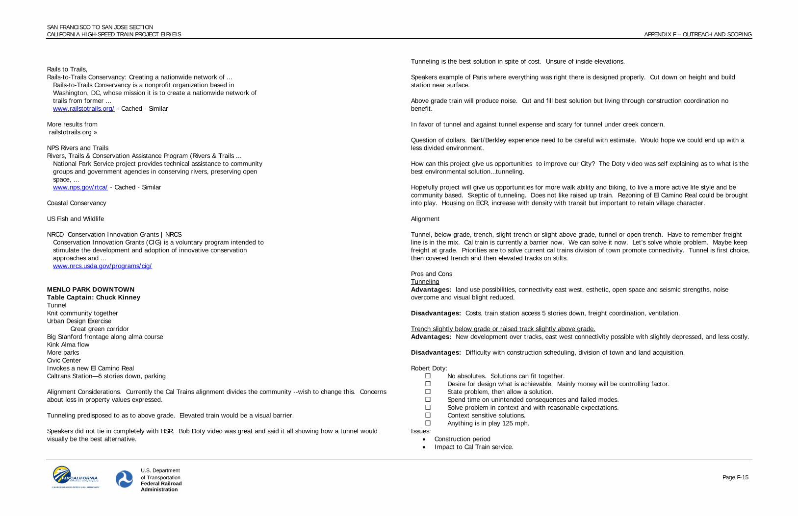
Rails to Trails, Rails-to-Trails Conservancy: Creating a nationwide network of ... Rails-to-Trails Conservancy is a nonprofit organization based in Washington, DC, whose mission it is to create a nationwide network of trails from former ... www.railstotrails.org/ - Cached - Similar More results from railstotrails.org » NPS Rivers and Trails Rivers, Trails & Conservation Assistance Program (Rivers & Trails ... National Park Service project provides technical assistance to community groups and government agencies in conserving rivers, preserving open space, ... www.nps.gov/rtca/ - Cached - Similar Coastal Conservancy US Fish and Wildlife NRCD Conservation Innovation Grants | NRCS Conservation Innovation Grants (CIG) is a voluntary program intended to stimulate the development and adoption of innovative conservation approaches and ... www.nrcs.usda.gov/programs/cig/ MENLO PARK DOWNTOWN Table Captain: Chuck Kinney Tunnel Knit community together Urban Design Exercise Great green corridor Big Stanford frontage along alma course Kink Alma flow More parks Civic Center Invokes a new El Camino Real Caltrans Station—5 stories down, parking Alignment Considerations. Currently the Cal Trains alignment divides the community --wish to change this. Concerns about loss in property values expressed. Tunneling predisposed to as to above grade. Elevated train would be a visual barrier. Speakers did not tie in completely with HSR. Bob Doty video was great and said it all showing how a tunnel would visually be the best alternative.
Tunneling is the best solution in spite of cost. Unsure of inside elevations. Speakers example of Paris where everything was right there is designed properly. Cut down on height and build station near surface. Above grade train will produce noise. Cut and fill best solution but living through construction coordination no benefit. In favor of tunnel and against tunnel expense and scary for tunnel under creek concern. Question of dollars. Bart/Berkley experience need to be careful with estimate. Would hope we could end up with a less divided environment. How can this project give us opportunities to improve our City? The Doty video was self explaining as to what is the best environmental solution…tunneling. Hopefully project will give us opportunities for more walk ability and biking, to live a more active life style and be community based. Skeptic of tunneling. Does not like raised up train. Rezoning of El Camino Real could be brought into play. Housing on ECR, increase with density with transit but important to retain village character. Alignment Tunnel, below grade, trench, slight trench or slight above grade, tunnel or open trench. Have to remember freight line is in the mix. Cal train is currently a barrier now. We can solve it now. Let’s solve whole problem. Maybe keep freight at grade. Priorities are to solve current cal trains division of town promote connectivity. Tunnel is first choice, then covered trench and then elevated tracks on stilts. Pros and Cons Tunneling Advantages: land use possibilities, connectivity east west, esthetic, open space and seismic strengths, noise overcome and visual blight reduced. Disadvantages: Costs, train station access 5 stories down, freight coordination, ventilation. Trench slightly below grade or raised track slightly above grade. Advantages: New development over tracks, east west connectivity possible with slightly depressed, and less costly. Disadvantages: Difficulty with construction scheduling, division of town and land acquisition. Robert Doty:
No absolutes. Solutions can fit together. Desire for design what is achievable. Mainly money will be controlling factor. State problem, then allow a solution. Spend time on unintended consequences and failed modes. Solve problem in context and with reasonable expectations. Context sensitive solutions. Anything is in play 125 mph.
Issues: • Construction period • Impact to Cal Train service.

SAN FRANCISCO TO SAN JOSE SECTION CALIFORNIA HIGH-SPEED TRAIN PROJECT EIR/EIS APPENDIX F – OUTREACH AND SCOPING
U.S. Department of Transportation Page F-16 Federal Railroad Administration
• R-O-W • Project costs • Incompatibility with fright • Gradient for freight 1% for HSR 2%. • Up and down gradient has power usage. • Noise with brakes • Control environment for emergencies • Noise • Construction impacts. Need 4 acres to stage for tunneling. • Costs: Tunnel vs. at grade 6 to 1, tunnel vs. elevated 3.5 or 4.2 to 1, cut trench to at grade 3.5 to 1 and cut
and cover 6 to 1. • Freight: try to get midnight to 5 am. • If freight is electrified then there would not need to be as many air vent shafts • UPS freight has 6,000 diesel engines • There is not enough right of way to have 4 tracks • At lease a mile is needed to justify a tunneling machine.
MENLO PARK NEIGHBORHOODS Table Captain: Henry L. Riggs Tunnel El Camino—downtown: visionary plan Automotive Way (Santa Clara to SF) Bus/Rapid Transit (at ends) Open Space Constraints: Cost Vent locations—every 1000’ Change locomotives? Develop R.O.W.
- bike path & sep ped. path - pocket parks - medium scale housing @ Stone Pine, Encinal - option for B.R.T. (may conflict w/housing opp.)
PED CROSSING @ BUCKTHORNE IMPROVED X’S @ ENCINAL, WATKINS, GLENWOOD Bruce – RVW – CA Ave. Oppty John Kricken – UCB
- once in lifetime opportunity HSR, and reconnecting East and West halves of town. Donlyn Lyndon – Prof. Emeritus UCB Tony Carrassco
- history of connection until recently – take opportunity now to reconnect - urban life opportunity downtown development
David Young – HMM – Tunneling Glen Isaacson – Funding Dominic (HSR) must summarize and submit this to have effect, due in December. Draft alternative analysis; city should respond TUNNEL OPTION OPPORTUNITIES
- less noise (mechanical and horns) - less crossing danger – connections - much better aesthetics v. raised line
- no constr. easement issues/shoe fly - BRT - air rights for (limited) development - bike route to parallel El Camino - restores property values - traffic crossings flow better - less pollution - Cal Train goes underground too - open space

SAN FRANCISCO TO SAN JOSE SECTION CALIFORNIA HIGH-SPEED TRAIN PROJECT EIR/EIS APPENDIX F – OUTREACH AND SCOPING
U.S. Department of Transportation Page F-17 Federal Railroad Administration
CONSTRAINTS - costs more - vent locations: conflicts with bus, bike? - payments for rights if wider than R.O.W. (should be minimal since benefits adj. property) - connecting to Atherton, Palo Alto - stations revised (elevators) - underground station aesthetics (Cal Train) - egress points - freight if not in tunnel limits R.O.W. reuse (buy them some electric locomotives?)
ALIGNMENT OPTIONS Rvw’d images in “sections” book catenary v. 3rd rail power ELEVATED – RANKED 3rd
Bad image of Embarcadero Freeway, Central Freeway, S.F. solid wall no way – open (?) better partly raised with dip for cars and ped’s., lowers structure Catewary is worst aesthetic, trees conflict view into homes (incl. 3 stories) N.G. – strong local opp. Sound broadcast from raised wheels
AT GRADE – RANKED 2nd Deep drop to underpass (assumes 5’ tracks) Better to make Encinal and Glenwood one-way to preserve sidewalks/side yards TUNNEL – RANKED 1st
HSR for sure – we don’t get station anyway Cal Train (second tunnel?) with station elevator freight rail preferred underground too – 6.3 miles, Atherton, M.P., P.A. – buy them some elect. locomotive
ATHERTON: “ATHERTON 2020” Table Captain: Claire Malone Prichard Tunnel 7 different elevations—avoid at grade Considered cut and cover for Caltrain Atherton channel (double box trench) tunnel 100’ deep Cover through civic area New senior center, new city hall, gym, Open area, Walking, civic center, library and art center All residential—unite the community Eliminate grade crossings Bike path COMMON QUESTION: WHAT DO WE DO NEXT? HOW DO WE GET THE HSR INTO THE GROUND?

SAN FRANCISCO TO SAN JOSE SECTION CALIFORNIA HIGH-SPEED TRAIN PROJECT EIR/EIS APPENDIX F – OUTREACH AND SCOPING
U.S. Department of Transportation Page F-18 Federal Railroad Administration
Attachment 3 – Context Sensitive Solutions
The Context Sensitive Solutions process is engaging a broad range of stakeholders along the San Francisco to San Jose corridor. Communities (home owner and neighborhood associations, downtown merchant associations and civic groups), interest groups (business, labor and environment) and public agencies (city, transportation and resource agencies) that are affected by or have an interest in the project are currently engaged in an integrated CSS, preliminary engineering and the environmental process.
Stakeholder Engagement
Local governments and their constituents are represented by a policymaker working group comprised of elected officials from the cities and counties and a technical working group comprised of staff from cities, transportation agencies and resource agencies along the corridor. Community organizers and civic leaders also are engaged and advocating for their constituent’s interests as input to the CSS process. State and federal legislators and their staff are informed and engaged on a regular basis.
A comprehensive range of issues and concerns regarding the potential impacts of the projects has been identified through public outreach during the EIR/S scoping process and stakeholder engagement as part of CSS.
Issues, Values, Goals and Opportunities
To provide input to the Draft Alternatives Analysis, the following Issues, Values and Goals Table presents issues identified by stakeholder groups by corridor sub-sections as part of the November 4, 2009 CSS workshop. Participants at this workshop were members of the policy working group, technical working group, community organizers and civic leaders. The results of the workshop were distributed to staff for each city along the corridor for comments. City staff comments are incorporated into the table.
The Issues, Values and Goals Table categorizes stakeholder issues by values and translates the issues into goal statements. Issues raised by stakeholders pertain to the corridor as a whole and specific areas along the corridor. Stakeholder groups are indicated as community, rail/project, environmental, business/labor and regulatory/funding interests. 10 sub-sections are identified, per the draft Alternatives Analysis. Values frame the range of desired outcomes related to quality of life, community character, mobility and connectivity, safety, economic vitality, financial feasibility, equity, natural environment, and sustainable infrastructure.
The Opportunities Table presents community desires, which are defined as local, or corridor wide desires that can be addressed with the project, or unique physical or community conditions where the implementation of the projects can realize mutual stakeholder and project benefits. Opportunities are organized by values for comparison to issues.

SAN FRANCISCO TO SAN JOSE SECTION CALIFORNIA HIGH-SPEED TRAIN PROJECT EIR/EIS APPENDIX F – OUTREACH AND SCOPING
U.S. Department of Transportation Page F-19 Federal Railroad Administration
Table – Issues, Values and Goals
VALUE ISSUE GOAL
SPECIFICALLY IDENTIFIED BY SUBSECTION STAKEHOLDERS Sub-
section 0 & 1
Sub-section
2
Sub-section
3
Sub-section
4
Sub-section
5
Sub-section
6
Sub-section
7
Sub-section 8 & 9
Comm-unity
Rail/ Project
Environ-ment
Business/ Labor
Regulatory/ Funding
A. QUALITY OF LIFE
1. Concern noise/vibration levels generated by project will impact quality of life of people living in proximity to project.
1.1 Project should not create more noise/vibration than there is today 1.2 Vibration felt from project and construction should not present threat to structural integrity of neighborhood structures 1.3 Placement and design of vent structures for tunnels should limit noise to an acceptable level in adjacent residential neighborhoods.
X X X X X X X X X X X X
2. Concern regarding property takes by project, disruption to residents’ lives and community, or loss of park space.
2.1 Project should minimize property takes for project and construction 2.2 Project should minimize loss of park lands 2.3 There should be no loss of housing 2.4 Impact on property values from presence and operation of railway must be mitigated
X X X X X X X X X X
3. Concerns regarding the visual impact (massive structure out of scale, low aesthetic value)
3.1. Project should utilize a unified theme for visible infrastructure, with localized design solutions that are appropriate for and are compatible with visual aesthetic of the community they are in 3.2. Project should avoid dividing the residential and commercial community more than it is divided today. 3.3. Project should minimize blocking of scenic view or vistas.
X X X X X X X X X X
4. Concern regarding increased air displacement impacts from increased train service and higher-speed trains.
4. Project should minimize and mitigate added air displacement where possible and practicable.
X X X X X X X
5. Minimize construction related traffic impacts (reductions in access, street parking capacity, truck traffic, shoofly limiting access, poor road conditions)
X X X X X X X X X X
6. Air quality due to Caltrain, HSR, and freight operations, as well as during construction, must be maintained within exiting regulatory limits
X X X X X X X
Subsection 2 Brisbane, SSF, San Bruno & Millbrae: minimize detrimental impacts to neighborhoods (especially those already
X X X X

SAN FRANCISCO TO SAN JOSE SECTION CALIFORNIA HIGH-SPEED TRAIN PROJECT EIR/EIS APPENDIX F – OUTREACH AND SCOPING
U.S. Department of Transportation Page F-20 Federal Railroad Administration
VALUE ISSUE GOAL
SPECIFICALLY IDENTIFIED BY SUBSECTION STAKEHOLDERS Sub-
section 0 & 1
Sub-section
2
Sub-section
3
Sub-section
4
Sub-section
5
Sub-section
6
Sub-section
7
Sub-section 8 & 9
Comm-unity
Rail/ Project
Environ-ment
Business/ Labor
Regulatory/ Funding
impacted by BART extension to Millbrae) by having the alignment underground. Subsection 3 Burlingame and San Mateo: (1) San Mateo has insufficient park space and desired a downtown plaza; (2) Century Theater in San Mateo could suffer from noise due to its close proximity to the tracks; (3) assess and mitigate impacts to Trinta Park baseball fields
X X X
Subsection 3 Burlingame and San Mateo and Subsection 5 Atherton and Menlo Park: (1) minimize reductions in adjacent property values
X X X
Section 7 Palo Alto: The alignment of HSR tracks, overhead wires and their supporting structures, and the design of grade separations must be inconspicuous and visually compatible with our one-story residential neighborhood.
X X X
Subsection 3 San Mateo and Subsection 8 & 9 Santa Clara and San Jose: minimize impacts on residential neighborhoods in (1) San Mateo and Burlingame and (2) in City of Santa Clara, College Park, Garden Alameda, Diridon/Georgetown, Newhall
X X X X X
Subsection 9 Santa Clara and San Jose: (1) building heights are low in San Jose due to airport restriction so impact of elevated structure is
X X X X X

SAN FRANCISCO TO SAN JOSE SECTION CALIFORNIA HIGH-SPEED TRAIN PROJECT EIR/EIS APPENDIX F – OUTREACH AND SCOPING
U.S. Department of Transportation Page F-21 Federal Railroad Administration
VALUE ISSUE GOAL
SPECIFICALLY IDENTIFIED BY SUBSECTION STAKEHOLDERS Sub-
section 0 & 1
Sub-section
2
Sub-section
3
Sub-section
4
Sub-section
5
Sub-section
6
Sub-section
7
Sub-section 8 & 9
Comm-unity
Rail/ Project
Environ-ment
Business/ Labor
Regulatory/ Funding
increased; (2) maintain, if possible, Bellarmine playing fields along ROW
B. COMMUNITY CHARACTER
1. Project will conflict with and restrict the development of existing/adopted and future general, redevelopment, precise, and specific plans.
1. Project should be coordinated with and compatible with TOD and redevelopment plans.
X X X X X X X X
2. The final infrastructure will clash with or impact current neighborhood and community character.
2. Project should be compatible with and not negatively impact community character or impact Historic preservation sites/districts.
X X X X X X X X X X X
3. Project should not physically divide the community more than it is divided today X X X X X X X X X X
4. Avoid structures significantly larger in scale when compared to immediate environment. X X X X X X X X
Subsection 1 San Francisco: alignment and infrastructure need to be compatible with urban design and planning, especially Mission Bay
X X X X X X
Subsection 2 Brisbane, SSF, San Bruno & Millbrae: (1) Address impacts of rail yard in Brisbane Bay lands in Environmental Document; (2) Minimize impacts to Brownfield redevelopment plans; (3) Design/alignment should be compatible (height restrictions?) with SFO; (4) Minimize impacts to neighborhoods (residential property takes, decrease in property values, etc.); (5) Design/alignment must be in conformance with Millbrae Station Area
X X X X X X

SAN FRANCISCO TO SAN JOSE SECTION CALIFORNIA HIGH-SPEED TRAIN PROJECT EIR/EIS APPENDIX F – OUTREACH AND SCOPING
U.S. Department of Transportation Page F-22 Federal Railroad Administration
VALUE ISSUE GOAL
SPECIFICALLY IDENTIFIED BY SUBSECTION STAKEHOLDERS Sub-
section 0 & 1
Sub-section
2
Sub-section
3
Sub-section
4
Sub-section
5
Sub-section
6
Sub-section
7
Sub-section 8 & 9
Comm-unity
Rail/ Project
Environ-ment
Business/ Labor
Regulatory/ Funding
Specific Plan
Subsection 3 Burlingame and San Mateo and Subsection 5 Atherton and Menlo Park: (1) minimize changes to historic Burlingame , Broadway, and Menlo Park Caltrain Station buildings, trees and parking; (2) alignment needs to respect residential community character;(3) minimize impact to future development opportunities; (3) maintain downtown San Mateo historic district just west of tracks
X X X X X X X
Subsection 6 Palo Alto: (1) preserve location and character of historic Palo Alto Caltrain station and Eichler homes; (2) minimize impacts to historic neighborhoods (Green Meadow Neighborhood) with out of scale structures, incompatible aesthetics
X X X X X X
Subsection 8 & 9 Santa Clara and San Jose:(1) incorporate aesthetics in design of elevated tracks and Diridon Station
X X X X
C. MOBILITY &
CONNECTIVITY
1. Caltrain/local transit service is reduced or less convenient, difficult to access, making it difficult to get to jobs/businesses, or making roads more congested and reducing air quality
1. Project should support enhanced Caltrain/local service through capital improvements that yield a service benefit, and minimize Caltrain service disruptions during construction. X X X X X X X X
2. The current Caltrain tracks limit the connectivity and mobility between the communities on either
2. Project should improve east-west connections and station area access for vehicles, pedestrians and bicycles; improve connections for emergency access and not impact emergency access during construction
X X X X X X X X X X X X

SAN FRANCISCO TO SAN JOSE SECTION CALIFORNIA HIGH-SPEED TRAIN PROJECT EIR/EIS APPENDIX F – OUTREACH AND SCOPING
U.S. Department of Transportation Page F-23 Federal Railroad Administration
VALUE ISSUE GOAL
SPECIFICALLY IDENTIFIED BY SUBSECTION STAKEHOLDERS Sub-
section 0 & 1
Sub-section
2
Sub-section
3
Sub-section
4
Sub-section
5
Sub-section
6
Sub-section
7
Sub-section 8 & 9
Comm-unity
Rail/ Project
Environ-ment
Business/ Labor
Regulatory/ Funding
side of the tracks.
3. Construction will restrict access to streets, properties, business, and/or downtowns/activity centers.
3. Project construction should minimize construction-related traffic, impacts to circulation patterns, and must maintain access to downtowns/activity centers and local businesses.
X X X X X X X X X
4. Traffic around the HSR stations will impact mobility and surrounding neighborhoods.
4. Project should be designed to adequately and efficiently support increased traffic to, within, and from the HSR stations. X X X X X X X X
5. Ensure multi-modal transit system capacity, frequency, coordination, and connectivity to minimize travel time to HSR stations
X X X X X X X X X
6. Project should support enhanced Caltrain/local service that provides a competitive alternative to vehicle travel in order to offset increases in vehicle travel from expected future increases in population.
X X X X X X X X X
7. Minimize traffic and parking impacts associated with HSR station X X X X X X X X X X
8. Minimize impacts to Caltrain service and stations, maintain peak hour service X X X X X X X X X X
9. Provide adequate parking and balanced station access modes X X X X X X X X X
10. The design of grade separations must maintain, and if possible, enhance the flow of traffic.
X X X X
Subsection 1 San Francisco: (1) allow surface transportation and connections Mission Bay at 16th and Common Streets; (2) note electric trolley line for 16th Street; (3) minimize long term traffic impacts with HSR station and allow balanced multi-modal access; (4) minimize door-to-door travel time to CBD
X X X X X

SAN FRANCISCO TO SAN JOSE SECTION CALIFORNIA HIGH-SPEED TRAIN PROJECT EIR/EIS APPENDIX F – OUTREACH AND SCOPING
U.S. Department of Transportation Page F-24 Federal Railroad Administration
VALUE ISSUE GOAL
SPECIFICALLY IDENTIFIED BY SUBSECTION STAKEHOLDERS Sub-
section 0 & 1
Sub-section
2
Sub-section
3
Sub-section
4
Sub-section
5
Sub-section
6
Sub-section
7
Sub-section 8 & 9
Comm-unity
Rail/ Project
Environ-ment
Business/ Labor
Regulatory/ Funding
Subsection 2 Brisbane, SSF, San Bruno and Millbrae: (1) Improve South San Francisco station functionality, location; (2) Consider relocation of Bayshore station to improve regional connectivity; (3) Maintain/restore access to Bayfront; (4) Coordinate design and construction of HST with Caltrain projects (SSF station, San Bruno grade separation and Station); (5) Maintain ability to extend California Drive north to Victoria; (6) prefers stacked 2-track alignment through Millbrae station and optimize use of existing facilities; (7) Maintain current level-of-service for the Millbrae/El Camino Real intersection post project; (8) mitigate traffic congestion at and around the proposed Millbrae station
X X X X X X
Subsection 3 Burlingame and San Mateo: (1) Enhance Millbrae Station; (2) accommodate residential access to HST; (3) Coordinate San Mateo and Burlingame Subsections; (4) Infrastructure should interface with California Drive in Burlingame and Site 1 in Millbrae; (5) Improve east-west connectivity for 31st and 28th Aves in San Mateo from El Camino Real on west to the east side of tracks; (6) maintain downtown San Mateo
X X X
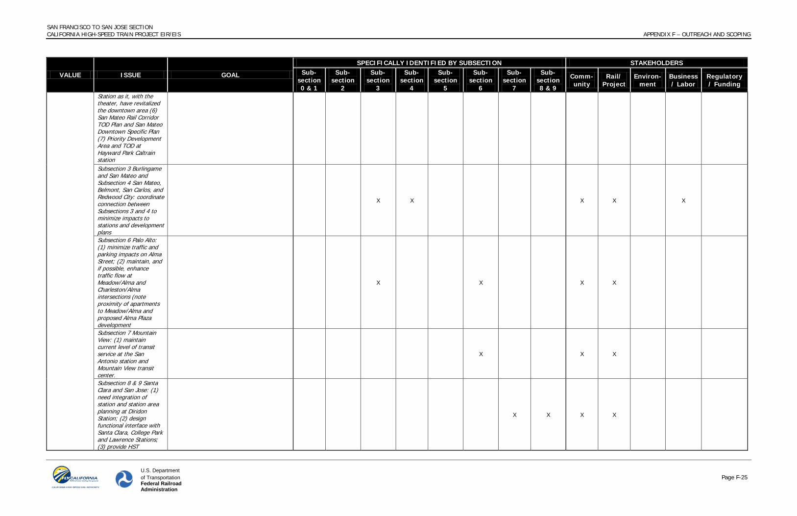
SAN FRANCISCO TO SAN JOSE SECTION CALIFORNIA HIGH-SPEED TRAIN PROJECT EIR/EIS APPENDIX F – OUTREACH AND SCOPING
U.S. Department of Transportation Page F-25 Federal Railroad Administration
VALUE ISSUE GOAL
SPECIFICALLY IDENTIFIED BY SUBSECTION STAKEHOLDERS Sub-
section 0 & 1
Sub-section
2
Sub-section
3
Sub-section
4
Sub-section
5
Sub-section
6
Sub-section
7
Sub-section 8 & 9
Comm-unity
Rail/ Project
Environ-ment
Business/ Labor
Regulatory/ Funding
Station as it, with the theater, have revitalized the downtown area (6) San Mateo Rail Corridor TOD Plan and San Mateo Downtown Specific Plan (7) Priority Development Area and TOD at Hayward Park Caltrain station Subsection 3 Burlingame and San Mateo and Subsection 4 San Mateo, Belmont, San Carlos, and Redwood City: coordinate connection between Subsections 3 and 4 to minimize impacts to stations and development plans
X X X X X
Subsection 6 Palo Alto: (1) minimize traffic and parking impacts on Alma Street; (2) maintain, and if possible, enhance traffic flow at Meadow/Alma and Charleston/Alma intersections (note proximity of apartments to Meadow/Alma and proposed Alma Plaza development
X X X X
Subsection 7 Mountain View: (1) maintain current level of transit service at the San Antonio station and Mountain View transit center.
X X X
Subsection 8 & 9 Santa Clara and San Jose: (1) need integration of station and station area planning at Diridon Station; (2) design functional interface with Santa Clara, College Park and Lawrence Stations; (3) provide HST
X X X X

SAN FRANCISCO TO SAN JOSE SECTION CALIFORNIA HIGH-SPEED TRAIN PROJECT EIR/EIS APPENDIX F – OUTREACH AND SCOPING
U.S. Department of Transportation Page F-26 Federal Railroad Administration
VALUE ISSUE GOAL
SPECIFICALLY IDENTIFIED BY SUBSECTION STAKEHOLDERS Sub-
section 0 & 1
Sub-section
2
Sub-section
3
Sub-section
4
Sub-section
5
Sub-section
6
Sub-section
7
Sub-section 8 & 9
Comm-unity
Rail/ Project
Environ-ment
Business/ Labor
Regulatory/ Funding
connections to city of Santa Clara; (4) CEMOF interface; (5) maintain station security; (6) ensure alignment compatibility from Diridon south to Merced.
D. SAFETY
1. Project will increase train traffic along the right-of-way thereby increasing the possibility of collisions.
1. Project should provide and increased level of safety at roadway, bicycle, and pedestrian crossings via grade separations; discourage trespassing.
X X X X X X X X
2. Pedestrian access to tracks is relatively unrestricted
2. Project should restrict pedestrian access to tracks given train speeds. X X X X X
3. Improve seismic safety preparedness and design X X X X X X X X
4. Provide adequate clearance at grade separations X X X X X X X
5. Provide adequate lighting X X X X X X X 6. Improve station security X X X X X X X X 7. Project should provide safety measures to
protect adjacent residential and commercial properties from derailments
X X X X
8. Project should consider impacts to soil (erosion) and foundations of structures along the right of way
X X X X X
9. Surface from project and construction should not increase flood risks. X X X X X X
10. Project construction should minimize/control use of hazardous materials X X X X X X X
11. Additional structures will add risk of graffiti/vandalism.
11. Design should minimize the number of hidden corners where vandalism can take place and use vandalism resistant materials.
X X X
Subsection 3 Burlingame and San Mateo and Subsection 4 San Mateo, Belmont, San Carlos, Redwood City: The following areas are in a flood zone: areas of downtown San Mateo, Sunnybrae/19th Av Park, Fiesta Gardens, and San Mateo/Glendale Village.
X X X X X X

SAN FRANCISCO TO SAN JOSE SECTION CALIFORNIA HIGH-SPEED TRAIN PROJECT EIR/EIS APPENDIX F – OUTREACH AND SCOPING
U.S. Department of Transportation Page F-27 Federal Railroad Administration
VALUE ISSUE GOAL
SPECIFICALLY IDENTIFIED BY SUBSECTION STAKEHOLDERS Sub-
section 0 & 1
Sub-section
2
Sub-section
3
Sub-section
4
Sub-section
5
Sub-section
6
Sub-section
7
Sub-section 8 & 9
Comm-unity
Rail/ Project
Environ-ment
Business/ Labor
Regulatory/ Funding
Subsection 6 Palo Alto: Vehicle, pedestrian, and bicycle crossings along Charleston Rd. and East/West Meadow Dr. should provide increased levels of safety as they are frequently used by children going to/coming from school.
X X X X
E. ECONOMIC VITALITY
1. The final infrastructure will limit visibility of businesses.
1. Project should maintain/help improve access/visibility/connections to downtowns and businesses.
X X X X X X X X X
2. The addition of HSR will negatively impact freight movement along the corridor.
2. Project should ensure freight can use the corridor to meet current and future demand. X X X X X X
3. Grade separations will limit access to adjacent businesses
3. Grade separations should minimize impacts to adjacent buildings X X X X X
4. Minimize negative impacts on downtown businesses and tax revenues X X X X X X X X X
5. Maintain freight rail service to major metropolitan centers and industries along the corridor.
X X X X X X X X
Subsection 1 San Francisco: (1) provide greatest redevelopment opportunities; (2) maintain rail access to the Port of San Francisco
X X X X X X
Subsection 2 Brisbane, SSF, San Bruno and Millbrae: maintain ability to develop sites identified in Millbrae Station Area Specific Plan as economic future is dependent on those developments.
X X X X
Subsection 3 Burlingame and San Mateo: (1) maintain parking and access to downtown San Mateo and Burlingame (both Broadway and Burlingame Ave.) during construction (2) Support TOD improvements for both Hayward Park
X X X X X X

SAN FRANCISCO TO SAN JOSE SECTION CALIFORNIA HIGH-SPEED TRAIN PROJECT EIR/EIS APPENDIX F – OUTREACH AND SCOPING
U.S. Department of Transportation Page F-28 Federal Railroad Administration
VALUE ISSUE GOAL
SPECIFICALLY IDENTIFIED BY SUBSECTION STAKEHOLDERS Sub-
section 0 & 1
Sub-section
2
Sub-section
3
Sub-section
4
Sub-section
5
Sub-section
6
Sub-section
7
Sub-section 8 & 9
Comm-unity
Rail/ Project
Environ-ment
Business/ Labor
Regulatory/ Funding
Station and Bay Meadows Phase II plans for the Hillsdale Station (3) construct 28th and 31st Ave. grade separations early to avoid impacts to Bay Meadows Phase II development which is already underway Subsection 7 Mountain View: (1) maintain existing level of parking and access to downtown business and Castro Street.
X X X X X X
F. FINANCIAL
FEASIBILITY
1. Cost overruns during planning/design/construction drain public and private resources
1. Project should be efficient in its use of public/private dollars during planning/design/construction.
X X X X X X X
2. Project cannot earn enough revenue to cover operating costs, state/fed must subsidize
2. Project should be designed to attract riders and earn revenue that matches its operating costs.
X X X X X X X X
3. Project will require the construction or re-construction of Caltrain projects and stations.
3. Project should coordinate design and construction of HSR and Caltrain in order to minimize construction time, excessive construction and infrastructure costs.
X X X X X X X X
4. Develop realistic schedule that can be met X X X X X X 5. Keep local community costs down. X X X X X X X
G. EQUITY
1. Project provides unequal level of enhancements to communities along the corridor
1. Project should be as equitable as possible in providing solutions that enhance communities along the corridor and must engage a wide and diverse range of community stakeholders.
X X X X X X X X
2. Ensure equal representation, participation and access to decision-making to support environmental justice.
X X X X X X X X
3. Do not disproportionately impact lower-income neighborhoods and locally owned businesses.
X X X X X X X X X
Subsection 3 Burlingame and San Mateo: housing, particularly affordable housing, is located alongside the rail corridor. If ROW acquisition is used, document affordable
X X X X

SAN FRANCISCO TO SAN JOSE SECTION CALIFORNIA HIGH-SPEED TRAIN PROJECT EIR/EIS APPENDIX F – OUTREACH AND SCOPING
U.S. Department of Transportation Page F-29 Federal Railroad Administration
VALUE ISSUE GOAL
SPECIFICALLY IDENTIFIED BY SUBSECTION STAKEHOLDERS Sub-
section 0 & 1
Sub-section
2
Sub-section
3
Sub-section
4
Sub-section
5
Sub-section
6
Sub-section
7
Sub-section 8 & 9
Comm-unity
Rail/ Project
Environ-ment
Business/ Labor
Regulatory/ Funding
housing loss along ROW and identify replacement housing
Subsection 5 Atherton and Menlo Park: (1) Ensure representation of North Fair Oaks neighborhood.
X X X X X
H. NATURAL ENVIRONME
NT
1. Construction and final infrastructure of the project will negatively affect the natural environment along the corridor.
1.1 Project should preserve and protect environmental resources and the natural environment during construction and with the final infrastructure. 1.2 Project should minimize impact to light pollution
X X X X X X X X X X
2. Minimize impacts on historic trees and urban tree canopy. X X X X X X X X
3.1 Preserve and minimize impacts on drainage channels and creeks. 3.2 Flooding must not occur as a result of blocking steams that intersect the railway
X X X X X X X X X X
4. Project shall not impact natural patterns of surface and sub-surface water and habitats for naturally-occurring plants and animals.
X X X X X
Subsection 2 Brisbane, SSF, San Bruno and Millbrae: preserve natural habitat of red legged frogs and California garner snake
X X X
Subsection 3 Burlingame and San Mateo: San Mateo Creek (1) is identified as a "high sensitivity" archeological area (2) should be preserved
X X X X X
Subsection 4 Belmont, San Carlos and Redwood City: preserve drainage channel at Cordilles Creek
X X X X X
San Mateo and Subsection 5 Atherton and Menlo Park: (1) preserve daylighted
X X X X X X

SAN FRANCISCO TO SAN JOSE SECTION CALIFORNIA HIGH-SPEED TRAIN PROJECT EIR/EIS APPENDIX F – OUTREACH AND SCOPING
U.S. Department of Transportation Page F-30 Federal Railroad Administration
VALUE ISSUE GOAL
SPECIFICALLY IDENTIFIED BY SUBSECTION STAKEHOLDERS Sub-
section 0 & 1
Sub-section
2
Sub-section
3
Sub-section
4
Sub-section
5
Sub-section
6
Sub-section
7
Sub-section 8 & 9
Comm-unity
Rail/ Project
Environ-ment
Business/ Labor
Regulatory/ Funding
creeks, with same water flow and quality (San Francisquito Creek, Atherton Channel); (2) minimize impacts on nearby parks
Subsection 3 Burlingame and Subsection 6 Palo Alto: (1) protect historic El Palo Alto tree; (2) protect urban tree canopy and character of the city;(3) preserve drainage channels of creeks, no reduction or obstruction of water flow or quality
X X X X X X
I. INFRASTRUC
TURE
1. Need to minimize disruption of water, sewer and storm drainage
1. Maintain operations and minimize disruption of water, sewer and storm drainage during construction; ensure no flooding at grade separations.
X X X X X X X X
2. Flooding should not occur at grade separations X X X X X X X X
3. Consider findings from Footprint Study X X X X X X X Subsection 2 Brisbane, SSF, San Bruno and Millbrae: (1) protect and/or relocate major water, sewer, and storm drainage facilities (High Line Canal, Cowan Canal,) and any changes in facilities should ensure no increase in Millbrae's long term maintenance costs
X X X

SAN FRANCISCO TO SAN JOSE SECTION CALIFORNIA HIGH-SPEED TRAIN PROJECT EIR/EIS APPENDIX F – OUTREACH AND SCOPING
U.S. Department of Transportation Page F-31 Federal Railroad Administration
Table – Opportunities
VALUE OPPORTUNITY
SPECIFICALLY IDENTIFIED BY SUBSECTION STAKEHOLDERS
Corridor-Wide
Sub-section 0 & 1
Sub-section
2
Sub-section
3
Sub-section
4
Sub-section
5
Sub-section
6
Sub-section
7
Sub-section 8 & 9
Comm-unity
Rail/ Project
Environ-ment
Business/ Labor
Regulatory/ Funding
A. QUALITY OF LIFE
1. Further mitigate existing impacts on communities (noise, visual, etc) X X X X X X X
2. Electrification X X X X X X
3. Cities/county green policies enactment for construction/deconstruction processes X X X
4. Off-site mitigations X X
5. Solar power X X X X
6. Add cultural experiences X X
7. Fix "bad" situations in communities X X X
8. Locate vents for underground tunnels along Alma where possible X
9. Fix CEMOF main line X X X
10 Construction should be confined to predictable schedules that are published in advance and adhered to. X X X X
B. COMMUNITY CHARACTER
1. Improve residential areas X X X X X
2. Increased open space and parks X X X X X X X
3. Improve aesthetics along rail alignment X X X
4. Improved station amenities X X X X
5. Improving / unifying divided communities X X X X X X X
6. Mixed-use; transit-oriented development X X X X X
7. Affordable housing X X
8. Linear park along rail alignment X X X
9. Improve landscaping X X X
10. Alignment option: Underground X X X X
11. Alignment option: Convert berm to viaduct (elevated) X X X
12. Alignment option: double-deck with HSR on top X X X X
13. Alignment option: HSR underground with Caltrain on top (except in downtown San Mateo) X X
14. Reduce speed; stay on two tracks; temporal separation; leverage baby bullet X X X X
15. Iconic station X X X
16. Santa Clara Station Area Plan X X
17. Create a sense of "place" X X X X
18. Pursue a vibrant urban center and a "grand" entrance into San Jose X X X X
19. Millbrae station square X X X X

SAN FRANCISCO TO SAN JOSE SECTION CALIFORNIA HIGH-SPEED TRAIN PROJECT EIR/EIS APPENDIX F – OUTREACH AND SCOPING
U.S. Department of Transportation Page F-32 Federal Railroad Administration
VALUE OPPORTUNITY
SPECIFICALLY IDENTIFIED BY SUBSECTION STAKEHOLDERS
Corridor-Wide
Sub-section 0 & 1
Sub-section
2
Sub-section
3
Sub-section
4
Sub-section
5
Sub-section
6
Sub-section
7
Sub-section 8 & 9
Comm-unity
Rail/ Project
Environ-ment
Business/ Labor
Regulatory/ Funding
20. Eliminate Kinder Morgan tank farm X X X
21. Create community assets (open spaces, mini-parks, etc) or new development consistent with community character on vacant land from proper takes
X X X X X X
22. San Mateo Downtown Specific Plan: calls for depression of tracks through downtown; San Mateo Rail Corridor TOD Plan X X X X X X
C. MOBILITY &
CONNECTIVITY
1. Improving passenger and freight travel X X X X X
2. Improve East/West Access and connectivity across tracks X X X X X X X
3. Connectivity - eliminate at-grade crossings / increase number of crossings X X X X X
4. Increase bike and pedestrian trails/access X X X X X
5. Improve Caltrain service with frequent local stops X X X X X X X
6. Improve feeder lines to Caltrain, HSR, BART X X X X X 7. For elevated alignments, provide bike and pedestrian access below X X
8. Use rail corridor to connect neighborhoods with bike/walking paths X X X X
9. Partnership with local transit agencies X X X
10. Reduce commuter time to central business district X X X
11. Improve access to Mission Bay Development X X
12. Relocate Bayshore station (southerly) X X X X
13. Provide connectivity to Downtown Brisbane X X X
14. Geneva Ave. extension X X
15. Enhance connectivity to bay (pedestrian access) X X X
16. Move South San Francisco station X X X
17. Provide seamless SFO connection X X X X X 18. Improve public transportation connectivity - airport, HSR, Caltrain X X X X X X
19. Improve efficiency of Broadway and Oak Grove X X
20. Improve traffic circulation in downtown Menlo Park X X X
21. Improve access to Town & Country Village X X X
22. Reconnect Alma X X
23. Improve Marguerite Shuttle X X
24. Improve access to Stanford events X X
25. Improve Palo Alto and California Ave. Caltrain stations X X X
26. Diridon Station (BART, HSR, Caltrain) X X X
27. Connection to Housing West of Diridon X X

SAN FRANCISCO TO SAN JOSE SECTION CALIFORNIA HIGH-SPEED TRAIN PROJECT EIR/EIS APPENDIX F – OUTREACH AND SCOPING
U.S. Department of Transportation Page F-33 Federal Railroad Administration
VALUE OPPORTUNITY
SPECIFICALLY IDENTIFIED BY SUBSECTION STAKEHOLDERS
Corridor-Wide
Sub-section 0 & 1
Sub-section
2
Sub-section
3
Sub-section
4
Sub-section
5
Sub-section
6
Sub-section
7
Sub-section 8 & 9
Comm-unity
Rail/ Project
Environ-ment
Business/ Labor
Regulatory/ Funding
28. Extend people-mover to San Bruno HSR station X X
29. People movers X X
30. Maintain, and if possible enhance, vehicular and pedestrian traffic flow at Meadow/Alma and Charleston/Alma intersections X X X X
31. Move Hillsdale Caltrain station north 1/2 mile and provide parking structures X X X X X X
32. Consider closing Hedding and creating Bellarmine pedestrian walkway and park area X X X X
33. Place the proposed Millbrae HSR station underground to allow Millbrae to develop Site 1 (as identified in the Millbrae Station Area Specific Plan) above it.
X X X X
33. Include bicycle facilities, like a Class 1 bikeway across US 101, as part of Millbrae station to encourage non-vehicular travel. X X X X X
D. SAFETY
1. Improve pedestrian, bicycle, and vehicle safety X X X X
2. Improve safety at crossings X X X X
3. Installation of crossing enhancements X X X X
4. Elimination of grade crossings X X X X X
5. Improve rail safety X X X
6. Improve intersection: University / El Camino Real X X
7. Improve safety of BHS X X
8. Elimination of at-grade crossings in downtown San Mateo, Burlingame, and Millbrae X X
E. ECONOMIC VITALITY
1. Tax base X X X
2. Promote new development X X X X
3. Leverage existing developments and investments X X X X
4. Station retail opportunities X X X X X
5. Increased tourist opportunities X X X
6. Expanded downtowns X X X
7. Real-estate development on/near ROW X X X X
8. Opportunities of air rights development with private businesses X X X
9. Develop more commercial opportunities along the rail and green space X X X X
10. Improved business districts in San Mateo, Burlingame, and Millbrae X X X
11. Improve freight rail access to port X X X
12. Brownfield remediation X X

SAN FRANCISCO TO SAN JOSE SECTION CALIFORNIA HIGH-SPEED TRAIN PROJECT EIR/EIS APPENDIX F – OUTREACH AND SCOPING
U.S. Department of Transportation Page F-34 Federal Railroad Administration
VALUE OPPORTUNITY
SPECIFICALLY IDENTIFIED BY SUBSECTION STAKEHOLDERS
Corridor-Wide
Sub-section 0 & 1
Sub-section
2
Sub-section
3
Sub-section
4
Sub-section
5
Sub-section
6
Sub-section
7
Sub-section 8 & 9
Comm-unity
Rail/ Project
Environ-ment
Business/ Labor
Regulatory/ Funding
F. FINANCIAL
FEASIBILITY
1. Opportunities of air rights development with private businesses X X X X X X
2. Funding of underground alignment through sale of air rights X X X X
3. Budget set asides must be earmarked for long term maintenance, as this should not fall on local communities. X X X X X
G. EQUITY 1. Project should provide for and help fund alternate modes of transportation to and from the proposed HSR stations to mitigate traffic congestion.
X X X X
H. NATURAL ENVIRONME
NT
1. Creek enhancements / flood control X X X
2. Colma creek improvements X X
3. Habitat restoration - west of Bayshore (SFO) X X
4. Recycle construction debris and reuse excavated soil as possible X X X
5. Preserve future potential for San Mateo Creek to "daylight" as much as possible and restore/maintain for salmon habitat X X X
I. INFRASTRUC
TURE
1. Utility extensions X X
2. Improve infrastructure X X X
3. Improve drainage system along and across tracks X X X X
4.Communication trunk / WiFi in rail ROW X X X X
5. Smart grid / networks / underground cabling X X X
6. Storm water quality basins X X X 7. Upgrade impacted storm drains to current 100 yr flooding standards X X X X