appendix f – prairie grouse lek survey
TRANSCRIPT

APPENDIX F – PRAIRIE GROUSE LEK SURVEY

Prairie Grouse Lek Survey Results for the Dakota Range III Wind Project
Roberts and Grant Counties, South Dakota
Prepared by:
Clayton Derby
Western EcoSystems Technology, Inc. 4007 State Street, Suite 109
Bismarck, ND 58503
September 21, 2018
Privileged and Confidential - Not For Distribution
~ WESli

Dakota Range III Wind Project, 2018 Lek Report
WEST, Inc. i September 21, 2018
TABLE OF CONTENTS
INTRODUCTION ....................................................................................................................... 1
PROJECT AREA ....................................................................................................................... 1
METHODS ................................................................................................................................. 1
RESULTS .................................................................................................................................. 2
CONCLUSION ........................................................................................................................... 2
REFERENCES .......................................................................................................................... 4
LIST OF FIGURES
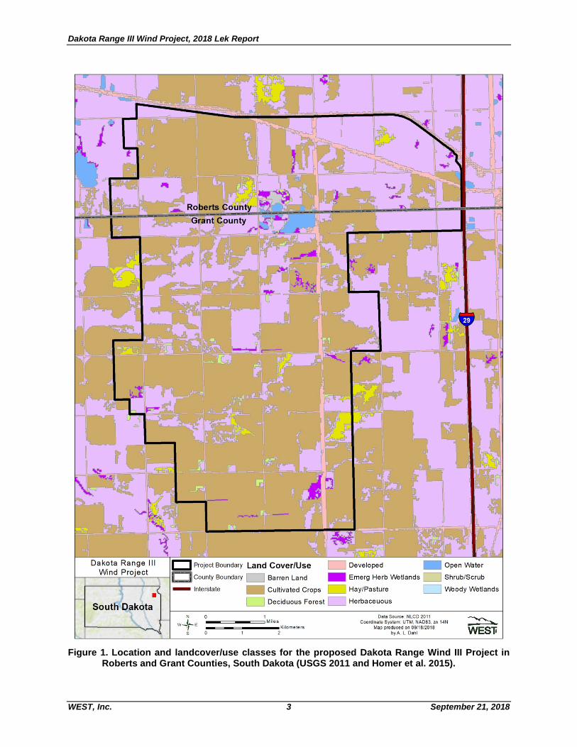
Figure 1. Location and landcover/use classes for the proposed Dakota Range Wind III Project in Roberts and Grant Counties, South Dakota (NLCD 2011 and Homer et al. 2015). ............................................................................................................................. 3
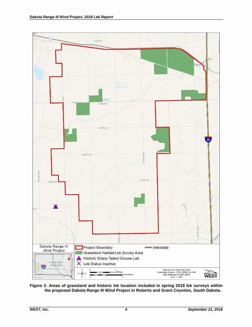
Figure 2. Areas of grassland and historic lek location included in spring 2018 lek surveys within the proposed Dakota Range III Wind Project in Roberts and Grant Counties, South Dakota. ................................................................................................................. 4

Dakota Range III Wind Project, 2018 Lek Report
WEST, Inc. 1 September 21, 2018
INTRODUCTION Western EcoSystems Technology, Inc. (WEST) completed a ground-based lek survey at the proposed Dakota Range III Wind Project (Project) in Roberts and Grant Counties, South Dakota (Figure 1). The purpose of this survey was to locate and evaluate 2018 status of prairie-grouse (sharp-tailed grouse [Tympanuchus phasianellus] and greater prairie-chicken [Tympanuchus cupido]) leks in and near the area proposed for development, so the Project can be designed to avoid or minimize risk of impact to these species. Surveys were completed from late March to early May in 2018 in accordance with protocols outlined in the South Dakota Department of Game, Fish and Parks (SDGFP) Wildlife Survey Manual (SDGFP 2009) and direction received during an October 2017 meeting with the SDGFP and US Fish and Wildlife Service.
PROJECT AREA The Project consists of approximately 18,601 acres located in the Big Sioux Basin Level IV Ecoregion, which is within the Northern Glaciated Plains Level III Ecoregion (US Environmental Protection Agency 2016). The predominant land cover/use types within the Project consists of approximately 55.8% cultivated crops and 34.6% herbaceous (grassland; US Geological Survey, National Land Cover Database 2011; Figure 1). The remaining land cover/use types account for less than 6.0% of the Project and include developed areas (5.3%), emergent herbaceous wetlands (1.4%), hay/pasture (1.2%), open water (0.8), deciduous forest (0.6), barren land (0.3%), and shrub scrub (<0.1). The most common cultivated croplands in 2017 were corn (Zea mays) and soybeans (Glycine max; US Department of Agriculture National Agricultural Statistics Service 2017).
METHODS
Prairie grouse are dependent on larger areas of prairie grasslands and conversion of grassland to cultivated agriculture is known to negatively impact distribution and abundance of grouse (SDGFP 2017). Because a large portion of the Project area is cultivated cropland, a desktop assessment of suitable grassland habitat was completed to refine the lek survey area prior to field surveys. Grassland habitats greater than 60 acres were considered to most likely support lekking grouse if present within the Project area. These larger grassland areas were identified based on review of aerial imagery (National Agriculture Imagery Program 2018) and data from the 2017 Crop Data Layer (US Department of Agriculture, National Agriculture Statistical Service 2018). Grassland tracts greater than 60 acres were digitized using ArcGIS 10 and thus comprised the lek survey area within the Project. Ground-based surveys were completed three times during spring 2018 within the lek survey area: Round 1 was completed from March 29 to April 17, 2018, Round 2 from April 18 to April 28, 2018, and Round 3 from May 10 to May 12, 2018. To the extent possible, surveys were conducted on relatively calm mornings (winds less than 20 miles per hour) with no rain. Historic

Dakota Range III Wind Project, 2018 Lek Report
WEST, Inc. 2 September 21, 2018
lek locations were provided by SDGFP in August 2015 for the Project area and vicinity, which included one sharp-tailed grouse lek approximately 0.75 mi southwest of the Project. This lek location was specifically evaluated three times, during the rounds described above, to determine the current status. Surveys were completed from 30 minutes prior to sunrise until approximately two hours after sunrise. The field biologist drove public roads around and within each grassland area and stopped every half-mile (805 meters; more often in hilly terrain) for 3-5 min to listen and look for displaying or calling grouse. If a lek was located, visually or by sound, the biologist mapped the location on paper maps and recorded the number of males, females, and birds of unknown sex attending the lek. If visual confirmation could not be achieved, the biologist attempted to triangulate the auditory observation from two or more locations. Leks were classified as “confirmed” if males were engaged in lek attendance behavior (e.g., dancing, calling) at the same location during more than one survey in 2018 or if observed in 2018 and in previous years at the same location. Leks were classified as “potential” when grouse males were observed in lek attendance behavior during only one survey in 2018. Historic leks were classified as “inactive” if no grouse activity was observed at the location during all three rounds of survey.
RESULTS Approximately 1,902.5 acres of grassland habitat greater than 60 acres were identified via desktop evaluation of the Project and surveyed for prairie grouse leks (Figure 2). No grouse leks were seen or grouse heard during any of the survey rounds. Thus, no prairie grouse leks were documented within the Project; the historic lek located southwest of the Project was inactive.
CONCLUSION
Lek surveys completed from late March to early May in 2018 indicate absence of prairie grouse leks within the area proposed for development.
Dakota Range III Wind Project, 2018 Lek Report
WEST, Inc. 3 September 21, 2018
Figure 1. Location and landcover/use classes for the proposed Dakota Range Wind III Project in
Roberts and Grant Counties, South Dakota (USGS 2011 and Homer et al. 2015).
Dakota Range Ill Wind Project
■
South Dakota
c:J Project Boundary Land Cover/Use
County Boundary - Barren Land
- Interstate - Cultivated Crops
- Deciduous Forest
N O 1
w-l--• :::::::::::::::.M.ile-• Kilometers S 2
- Emerg Herb Wetlands Shrub/Scrub
- Hay/Pasture LJ Wood y Wetlands
Herbaceuous
Data Source: NLCD 2011 Coordina te System: UTM, NA083, zn 14N
Map produced on 09/18/2018 by A. L. Dahl
~ WEST,
Dakota Range III Wind Project, 2018 Lek Report
WEST, Inc. 4 September 21, 2018
Figure 2. Areas of grassland and historic lek location included in spring 2018 lek surveys within
the proposed Dakota Range III Wind Project in Roberts and Grant Counties, South Dakota.
1963n
144
mi,,, GR ANT
1451h SI
" 146thSI < ~ .,, .,.
" < ~ .., 1471h St .,.
.. ~ SI "'
Dakota Range 111 c:] Project Boundary - Interstate
t---;:::==Wi=,n=d=P=ro:::::je=c=t= ::::;-1 • Grassland Habitat/Lek Survey Area
_. Historic Sharp-Tailed Grouse Lek
X Lek Status Inactive
N O 1 L - -== =-- -== Miles w7 E - =--====-----Kilometers S 2
Data Source : Wor1d Topo Map Coordinate System: UTM, NA083, zn 14N
Map produced on 09/21 /2018 by A. L. Dahl
~ WEST,

Dakota Range III Wind Project, 2018 Lek Report
WEST, Inc. 5 September 21, 2018
REFERENCES
Homer, C.G., J.A. Dewitz, L. Yang, S. Jin, P. Danielson, G. Xian, J. Coulston, N.D. Herold, J.D. Wickham, and K. Megown. 2015. Completion of the 2011 National Land Cover Database for the Conterminous United States-Representing a Decade of Land Cover Change Information. Photogrammetric Engineering and Remote Sensing 81(5): 345-354. Available online from: http://www.mrlc.gov/nlcd2011.php
South Dakota Department of Game, Fish and Parks (SDGFP). 2009. Wildlife Survey Manual 2009-2015. Division of Wildlife, Pierre, South Dakota. 187 pages.
US Environmental Protection Agency (USEPA). 2016. Ecoregion Download Files by State - Region 8: South Dakota. Ecoregions of the United States, Ecosystems Research, USEPA. Information and maps available online at: https://www.epa.gov/eco-research/ecoregion-download-files-state-region-8#pane-39
US Geological Survey (USGS). 2011. National Land Cover Database 2011 (NLCD 2011). Multi-Resolution Land Characteristics Consortium (MRLC), National Land Cover Database (NLCD). USGS Earth Resources Observation and Science (EROS) Center, Sioux Falls, South Dakota. Information available online at: http://www.mrlc.gov/nlcd2011.php
US Department of Agriculture (USDA). 2018. Imagery Programs - National Agriculture Imagery Program (NAIP). USDA, Farm Service Agency (FSA), Aerial Photography Field Office (APFO), Salt Lake City, Utah. Information online: https://www.fsa.usda.gov/programs-and-services/aerial-photography/imagery-programs/index
US Department of Agriculture (USDA) National Agricultural Statistical Service (NASS). 2018. Cropscape and Cropland Data Layer. 2017 Cropland Data Layer, Research and Science, USDA NASS, Washington, D. C. Information online: https://www.nass.usda.gov/Research_and_Science/Cropland/SARS1a.php