appendix f - toronto hydro · 2.0 property inspection ... appendix a: maps ... windsor transformer...
TRANSCRIPT

APPENDIX F
STAGE 1 ARCHAEOLOGICAL ASSESSMENT


Stage 1 Archaeological Assessment (AA) for the:
Proposed Bremner Transformer Station Site
City of Toronto
Ontario
Project Numbers: 003-TO397-09
Licensee: Jessica Marr
PIF#: P334-087-2011
Original Report
July 14th
, 2011
Presented to:
IBI Group 30 International Boulevard
Toronto, Ontario
M9W 5P3
T: 416.679.1930
F: 416.675.4620
Prepared by:
Archeoworks Inc.
16715-12 Yonge Street
Suite #1029
Newmarket, Ontario
L3X 1X4
T: 416.676.5597
F: 416.676.5810
AR
CH
EO
WO
RK
S I
NC
.


Archeoworks Inc.
Stage 1 AA for the Proposed Bremner Transformer Station, City of Toronto i
Executive Summary
Archeoworks Inc. was retained by the IBI Group to conduct a Stage 1 archaeological
assessment (AA) of the proposed Bremner Transformer Station („Bremner TS‟), location on
land in the Rees Street and Bremner Boulevard area (bounded to the north by Bremner
Boulevard, south by Lakeshore Boulevard, west by Rees Street, and east by Roundhouse
Park).
Stage 1 background research was conducted to evaluate the study area‟s potential to contain
archaeological resources and to illustrate the specific features contributing to the classification
of high potential zones. Regarding the historic potential of the study area, the Archaeological
Master Plan of the Central Waterfront (ASI, 2003) revealed the entire study area to be under
Lake Ontario prior the early 1900s. The central portion of the waterfront is one in which
massive landscape changes occurred from the mid to late nineteenth century, through massive
filling activities, to accommodate the development of the railways and new infrastructures.
The Master Plan mapping revealed the study area to be situated within and adjacent to a
significant historic feature: the Canadian Pacific (CP) Railway Roundhouse. As such, if
significant undisturbed archaeological resources are deeply buried below the study area, they
would likely be associated with the early railway technology from the 1893-1931 period.
However, the original roundhouse was built in 1897 and replaced in 1918 to accommodate
additional filling of the area, to raise the height of the railway corridor, and are now located in
its present location; both these features are located within and adjacent to the study area.
Over 1,000,000 cubic yards of fill from pits located in Scarborough were needed to complete
the project. Since then, the grades in the study area and surrounding area have undergone
further transformation and have been lowered from the c.1920s elevation to somewhat above
the historic land/harbour elevations. In addition, much of the area, including much of the
roundhouse, was excavated for the buried part of the Metro Toronto Convention Centre.
These excavation activities have provided a substantial amount of information of the railway
technology of the area, which is now well understood.
Additional background research confirmed the presence of two designated heritage properties
within 100 metres of the study area and that nine archaeological sites have been found within
a one-kilometre radius of the study area. One of these sites is located within 300 metres of the
study area, suggesting that additional archaeological sites may be encountered within its
limits. In terms of Aboriginal archaeological potential, as the study area was submerged
under Lake Ontario until c.1910-1931, and then subjected to intensive land filling, any
evidence of precontact occupation in this area would have been destroyed or dispersed.
Furthermore, given the study area was under water until the early 1900s, there is low potential
for the recovery of early nineteenth century historic remains. Therefore, given the extensive
soil disturbance within the study area and surrounding lands, as well as the extensive
knowledge and excavation previously conducted on the roundhouse and railway technology
of the area, it is unlikely that substantial archaeological resources may still be present. As
well, it is unlikely that further knowledge may be gained from additional archaeological
investigation.


Archeoworks Inc.
Stage 1 AA for the Proposed Bremner Transformer Station, City of Toronto ii
TABLE OF CONTENTS
Executive Summary .................................................................................................................. i
Table of Contents ..................................................................................................................... ii
Project Personnel .................................................................................................................... iii
1.0 Project Context
1.1 Development Context ................................................................................................. 1
1.2 Historical and Precontact Archaeological Context .................................................. 1-6
2.0 Property Inspection ............................................................................................................ 6
3.0 Analysis and Conclusions .................................................................................................. 6
4.0 Recommendations .............................................................................................................. 7
5.0 Advice on Compliance with Legislation......................................................................... 7-8
6.0 Bibliography and Sources ............................................................................................. 9-10
Tables
Table 1: Listed and Designated Heritage Properties within 100 metres of the Study Area ............... 3
Table 2: Sites within One Kilometre Radius of the Study Area .................................................. 3-4
Table 3: History of Occupation in Southern Ontario .................................................................. 4-5
Appendices
Appendix A: Maps ............................................................................................................. 10-17
Appendix B: Images ............................................................................................................... 18
Appendix C: Inventory of Documentary and Material Record .................................................... 19

Archeoworks Inc.
Stage 1 AA for the Proposed Bremner Transformer Station, City of Toronto iii
Project Personnel:
Project Director Jessica Marr – MTC license P334
Review Archaeologists Nimal Nithiyanantham – MTC license R331
Kim Slocki – MTC license P029
Report Preparation Nimal Nithiyanantham – MTC license R331
Graphics Nimal Nithiyanantham – MTC license R331

Archeoworks Inc.
Stage 1 AA for the Proposed Bremner Transformer Station, City of Toronto 1
1.0 PROJECT CONTEXT
1.1 Development Context
Toronto Hydro-Electric System Limited (THESL) is undertaking a Class Environmental
Assessment (EA) study for the construction and operation of a new Transformer Station
(“Bremner TS”) on land in the Rees Street and Bremner Boulevard area (bounded to the north
by Bremner Boulevard, south by Lakeshore Boulevard, west by Rees Street, and east by
Roundhouse Park)1.
To facilitate this study, Archeoworks Inc. was retained by the IBI Group to conduct a Stage 1
archaeological assessment (AA) of the proposed construction of the new Bremner TS (see
Map 1). This new electricity source is needed to replace obsolete equipment at the existing
Windsor Transformer Station.
This Stage 1 AA was conducted under the project and field direction of Ms. Jessica Marr,
under archaeological consulting license P334, in accordance with the Ontario Heritage Act
(1990). This study will be conducted in accordance with the requirements of the Class
Environmental Assessment Process for Minor Transmission Facilities, pursuant to the
Environmental Assessment Act. Permission to review and assess the archaeological potential
of the study area was provided via the landowner‟s representative, the IBI Group, on June
21st, 2011.
1.2 Historical and Precontact Archaeological Context
1.2.1 Determining Archaeological Potential
The Stage 1 background research is conducted to evaluate the study area‟s potential to contain
archaeological resources. Archeoworks did not attempt to evaluate prehistoric potential for
the study area, since extensive soil disturbance existed in the area. As well, the entire study
area was originally part of Toronto‟s harbour rather than dry land. Historic potential is
determined following an assessment of physical and historical features in the immediate area,
as well as the proximity of previously identified archaeological sites. If potential is
established, a Stage 2 assessment and/or monitoring must be conducted to confirm the
presence of archaeological resources. The results of the background research are provided
below.
1.2.2 Archaeological Significance
To establish the archaeological significance of the study area, Archeoworks Inc. conducted a
comprehensive review of: the Archaeological Master Plan of the Central Waterfront, the
Waterfront Toronto – Archaeological Conservation & Management Strategy document,
registered archaeological sites, and listed and designated heritage properties within close
proximity to their limits. Furthermore, a review of the physiography of the overall area and
1http://www.torontohydro.com/sites/electricsystem/powerup/Documents/BREMNER%20EA_April%2012_Final

Archeoworks Inc.
Stage 1 AA for the Proposed Bremner Transformer Station, City of Toronto 2
its correlation to locating archaeological remains, as well as consultation of available historic
documentation was performed. The results of this background research are documented
below.
A review of the Archaeological Master Plan of the Central Waterfront (ASI, 2003) revealed
the entire study area to be under Lake Ontario prior the early 1900s (see Map 2). The central
portion of the waterfront is one in which massive landscape changes occurred from the mid to
late nineteenth century, through massive filling activities, to accommodate the development of
the railways and new infrastructures (ASI, 2003). This process vastly altered the original
shape of Toronto‟s waterfront and created a succession of shorelines.
The Master Plan mapping, however, revealed the study area to be situated adjacent to a
significant historic feature: the Canadian Pacific (CP) Railway Roundhouse (see Map 2).
Mapping within the Waterfront Toronto – Archaeological Conservation & Management
Strategy (ASI, 2008), revealed the presence of the original roundhouse, as well the latter
roundhouse to be within the limits of the study area (see Map 3). The first 15 stalls and the
turntable of the original CP Roundhouse were completed in 1897 in an area between the
present day CN Tower and the John Street Roundhouse (see Map 3). In 1907, an additional
five stalls were added and in 1918 a further seven were constructed. The original 1897
turntable was replaced in 1918. As such, if significant undisturbed archaeological resources
are deeply buried below the study area, they would likely be associated with the early railway
technology from the 1893-1931 period. However, the original building and its associated
structures were removed in 1929 to accommodate additional filling of the area, to raise the
height of the railway corridor, and are now located in its present location. Over 1,000,000
cubic yards of fill from pits located in Scarborough were needed to complete the project
(Historic Research Limited, 1989). The new locomotive house was about 17 feet higher than
the original roundhouse.
Since then, the grades in the study area and surrounding area have undergone further
transformation, and have been lowered from the c.1920s elevation to somewhat above the
historic land/harbour elevations. In addition, much of the area, including much of the
roundhouse, was excavated for the buried part of the Metro Toronto Convention Centre (see
Map 4) (C. Andreae 2011, pers. comm. 8 July). These excavations activities have provided a
substantial amount of information of the railway technology of the area, which is now well
understood.
1.2.3 Listed and Designated Properties
Consultation of the records for listed and designated heritage properties within the City of
Toronto’s Inventory of Heritage Properties, as well as the Ontario Ministry of Tourism and
Culture’s2 database,
3, confirmed the presence of two designated heritage properties within
100 metres of the study area (see Table 1).
2 Clarification: As of 2005, the Ontario Heritage Properties Database is no longer being updated. The Ministry
of Tourism & Culture is currently updating a new system which will provide much greater detail to users and
will become publicly accessible in the future. (http://www.hpd.mcl.gov.on.ca) 3 http://www.markham.ca/wps/portal/Markham/AboutMarkham/Heritage
Archeoworks Inc.
Stage 1 AA for the Proposed Bremner Transformer Station, City of Toronto 3
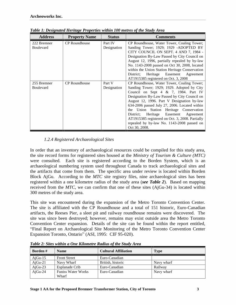
Table 1: Designated Heritage Properties within 100 metres of the Study Area
Address Property Name Status Comments
222 Bremner
Boulevard
CP Roundhouse Part IV
Designation
CP Roundhouse, Water Tower, Coaling Tower;
Sanding Tower; 1929; 1929 -ADOPTED BY
CITY COUNCIL ON SEPT. 4 AND 7, 1984 -
Designation By-Law Passed by City Council on
August 12, 1996, partially repealed by by-law
No. 1143-2008 passed on Oct 30, 2008, located
within the Union Station Heritage Conservation
District; Heritage Easement Agreement
AT1915385 registered on Oct. 3, 2008
255 Bremner
Boulevard
CP Roundhouse Part V
Designation
CP Roundhouse, Water Tower, Coaling Tower;
Sanding Tower; 1929; 1929. Adopted by City
Council on Sept 4 & 7, 1984. Part IV
Designation By-Law Passed by City Council on
August 12, 1996. Part V Designation by-law
634-2006 passed July 27, 2006. Located within
the Union Station Heritage Conservation
District; Heritage Easement Agreement
AT1915385 registered on Oct. 3, 2008. Partially
repealed by by-law No. 1143-2008 passed on
Oct 30, 2008.
1.2.4 Registered Archaeological Sites
In order that an inventory of archaeological resources could be compiled for this study area,
the site record forms for registered sites housed at the Ministry of Tourism & Culture (MTC)
were consulted. Each site is registered according to the Borden System, which is an
archaeological numbering system used throughout Canada to track archaeological sites and
the artifacts that come from them. The specific area under review is located within Borden
Block AjGu. According to the MTC site registry files, nine archaeological sites has been
registered within a one kilometre radius of the study area (see Table 2). Based on mapping
received from the MTC, we can confirm that one of these sites (AjGu-34) is located within
300 metres of the study area.
This site was encountered during the expansion of the Metro Toronto Convention Center.
The site is affiliated with the CP Roundhouse and a total of 151 historic, Euro-Canadian
artifacts, the Reeses Pier, a sleet pit and railway roundhouse remains were discovered. The
site was since been destroyed; however, remains may exist outside area the Metro Toronto
Convention Center expansion. Details of the site can be found within the report entitled,
“Final Report on Archaeological Site Monitoring of the Metro Toronto Convention Center
Expansion Toronto, Ontario” (ASI, 1995: CIF 95-020).
Table 2: Sites within a One Kilometre Radius of the Study Area
Borden # Name Cultural Affiliation Type
AjGu-15 Front Street Euro-Canadian
AjGu-21 Navy Wharf British, historic Navy wharf
AjGu-23 Esplanade Crib Euro-Canadian Railway
AjGu-24 Funiss Water Works
Wharf
Euro-Canadian Navy wharf

Archeoworks Inc.
Stage 1 AA for the Proposed Bremner Transformer Station, City of Toronto 4
Borden # Name Cultural Affiliation Type
AjGu-25 1894 Landfill Euro-Canadian Domestic dump
AjGu-28 Elgin-Winter Garden
Theatre
Euro-Canadian Well
AjGu-34 * Euro-Canadian Roundhouse, railway
AjGu-48 The Grange ** **
AjGu-50 Ontario Heritage Centre Euro-Canadian Commercial building
* Indicates an unnamed site
** All data from form has not yet been entered into the database
Having noted the presence of these sites in relation to the study area, it is useful to place them
in the proper context by reviewing the cultural history of occupation in Southern Ontario
provided in Table 3 below. This data provides an understanding of the potential cultural
activity that may occurred within the study area.
Table 3: History of Occupation in Southern Ontario
Period Archaeological Culture Date Range Attributes
PALEO-INDIAN
Early Gainey, Barnes, Crowfield 9000-8500 BC Big game hunters. Fluted projectile
points
Late Holcombe, Hi-Lo, Lanceolate 8500-7500 BC Small nomadic hunter-gatherer
bands. Lanceolate projectile points
ARCHAIC
Early Side-notched, corner notched,
bifurcate-base
7800-6000 BC Small nomadic hunter-gatherer
bands; first notched and stemmed
points, and ground stone celts.
Middle Otter Creek , Brewerton 6000-2000 BC Transition to territorial settlements
Late Narrow, Broad and Small Points
Normanskill, Lamoka, Genesee, Adder
Orchard etc.
2500-500 BC More numerous territorial hunter-
gatherer bands; increasing use of
exotic materials and artistic items
for grave offerings; regional trade
networks
WOODLAND
Early Meadowood, Middlesex 800-400 BC Introduction of pottery, burial
ceremonialism; panregional trade
networks
Middle Point Peninsula, Saugeen, Jack‟s Reef
Corner Notched
400 BC-AD 800 Cultural and ideological influences
from Ohio Valley complex societies;
incipient horticulture
Late Algonquian, Iroquoian AD 800-1300 Transition to village life and
agriculture
Algonquian, Iroquoian AD 1300-1400 Establishment of large palisaded
villages
Algonquian, Iroquoian AD 1400-1600 Tribal differentiation and warfare
HISTORIC
Early Huron, Neutral, Petun, Odawa, Ojibwa AD 1600 – 1650 Tribal displacements
Late Six Nations Iroquois, Ojibwa,
Mississauga
AD 1650 – 1800s Migrations and resettlement

Archeoworks Inc.
Stage 1 AA for the Proposed Bremner Transformer Station, City of Toronto 5
Period Archaeological Culture Date Range Attributes
Euro-Canadian AD 1780 - present European immigrant settlements
1.2.5 Physical Features – Precontact Potential
The study area is situated within the Iroquois Plain physiographic region of Southern Ontario,
which extends around the western part of Lake Ontario, from the Niagara River to the Trent
River, its width varying from a few hundred yards to about eight miles. The lowland
bordering Lake Ontario, when the last glacier was receding but still occupied the St.
Lawrence Valley, was inundated by a body of water known as Lake Iroquois. The undulating
till plains above its old shorelines make up the Iroquois plain (Chapman & Putnam, 1984).
The Iroquois lake plain, cut in previously deposited clay and till, is partly floored with sand
deposits; from Scarborough to Trenton the plain widens until the old beach is six and one-half
miles inland from the present shore of Lake Ontario. The old shoreline is well marked by
bluffs or gravel bars while immediately below is a strip of boulder pavement and sandy off-
shore deposits which vary in width. Poorly drained, this coarse sandy soil is not very
productive. Prior to 1930, until 1940, the Iroquois plain was a general farming area, with a
tendency for horticulture and growth of canning crops. Since the Second World War, the
remaining farms have become larger while much of the land has been put to urban uses.
In terms of archaeological potential, potable water is arguably the single most important
resource necessary for any extended human occupation or settlement. As water sources have
remained relatively stable in southern Ontario since post-glacial times, proximity to water can
be regarded as a useful index for the evaluation of archaeological site potential. Indeed,
distance from water has been one of the most commonly used variables for predictive
modeling of site location. In Southern Ontario, the 2011 Standards and Guidelines for
Consultant Archaeologists stipulate that undisturbed lands within 300 metres of a water
source to be of elevated archaeological potential. Prior to about 3000BC, Toronto‟s shore line
was further south of the 19th
century shore line. As such, any prehistoric sites south of the
19th
century shore line would have been destroyed by the rising lake level, as well as the
extensive soil disturbance the area experienced during its development. Therefore, we find no
potential to encounter prehistoric remains within the limits of the site.
1.2.6 Historical Features
To assess the potential for the recovery of historic remains within the limits of the study area,
a review of available maps pertaining to the study area and its immediate surroundings was
conducted at the City of Toronto Archives in order to gain an understanding of the land-use
history.
According to the earliest map available Plan of York, Leiut. Philpotts, 1818 (see Map 5), the
study area is illustrated as falling within Lake Ontario. Further review within the 1860
Tremaine’s Map of the County of York and 1878 Illustrated Atlas of the County of York
revealed the study area to remain submerged beneath Lake Ontario; however, the shoreline
was illustrated as being expanded further south (see Maps 6-7).

Archeoworks Inc.
Stage 1 AA for the Proposed Bremner Transformer Station, City of Toronto 6
It was not until c.1910-1931 when the study area and surrounding lands were infilled. Given
the development pattern of the study area, it was not until the early twentieth century when it
started developing. As such, if significant undisturbed archaeological resources are deeply
buried below the study area, they would likely be associated with the early railway technology
from the 1893-1931 period.
1.2.7 Current Land-Use(s)
This Stage 1 AA of the study area, illustrated in Map 8, was undertaken on July 14th
, 2011.
The study area is situated along the City of Toronto‟s Waterfront, and consists primarily of
reclaimed lands which are currently affiliated with the roundhouse.
2.0 Property Inspection
A desktop review of the subject lands was undertaken employing Google Street View.
Photographic images of the study area are presented within Appendix B. Location and
orientation information associated with all photographs taken in the field are provided on
Map 8.
3.0 Analysis and Conclusions
The Stage 1 background research was conducted to evaluate the study area‟s potential to
contain archaeological resources. The study area experienced extensive land alteration
activities since c.1893; with much of the development occurring around c.1910-1931. The
original roundhouse, located adjacent to the study area, was built in 1897 and replaced in
1918 to accommodate additional filling of the area, to raise the height of the railway corridor,
and are now located in its present location; both these features are located within and adjacent
to the study area. Over 1,000,000 cubic yards of fill from pits located in Scarborough were
needed to complete the project (Historic Research Limited, 1989). The new locomotive house
was about 17 feet higher than the original roundhouse.
In addition, as noted above, the grades in the study area and surrounding area have been
further heavily disturbed by development activities to lower the grade from the c.1920s
elevation to somewhat above the historic land/harbour elevations. Moreover, much of the
area has been excavated for the buried part of the Metro Toronto Convention Centre, and,
thus, the railway technology is well understood for this part of the city (C. Andreae 2011,
pers. comm. 14 July).
Given the extensive soil disturbance within the study area and surrounding lands, as well as
the extensive knowledge and excavation previously conducted on the roundhouse and railway
technology of the area, it is unlikely that substantial archaeological resources may still be
present. As well, it is unlikely that further knowledge may be gained from additional
archaeological investigation.

Archeoworks Inc.
Stage 1 AA for the Proposed Bremner Transformer Station, City of Toronto 7
4.0 RECOMMENDATIONS
The Stage 1AA for the proposed construction of the new Bremner TS Cable on land in the
Rees Street and Bremner Boulevard area, revealed the area to have been extensively
disturbed, as well as documented through previous archaeological excavation. As a result of
these findings, it is recommended that:
1. Given the railway technology and surrounding area is well understood, as well as the
extensive disturbance to the study area, the subject lands may be considered free of
further archaeological concern.
5.0 ADVICE ON COMPLIANCE WITH LEGISLATION
1. This report is submitted to the City’s Planning Division (Heritage Preservation
Services Unit) and Ministry of Tourism and Culture as a condition of licensing in
accordance with Part VI of the Ontario Heritage Act, R.S.O. 1990, c0.18. The report
is reviewed to ensure that it complies with the standards and guidelines that are issued
by the Minister, and that the archaeological fieldwork and report recommendations
ensure the conservation, protection and preservation of the cultural heritage of
Ontario. When all matters relating to archaeological sites within the project area of a
development proposal have been addressed to the satisfaction of the Ministry of
Tourism and Culture, a letter will be issued by the ministry stating that there are no
further concerns with regard to alterations to archaeological sites by the proposed
development. Until this letter is received, no excavation activities shall take place on
the subject property.
2. It is an offence under Sections 48 and 69 of the Ontario Heritage Act for any party
other than a licensed archaeologist to make any alteration to a known archaeological
site or to remove any artifact or other physical evidence of past human use or activity
from the site, until such time as a licensed archaeologist has completed archaeological
fieldwork on the site, submitted a report to the Minister stating that the site has no
further cultural heritage value or interest, and the report has been filed in the Ontario
Public Register of Archaeology Reports referred to in Section 65.1 of the Ontario
Heritage Act.
3. Should previously undocumented archaeological resources be discovered, they may be
a new archaeological site and therefore subject to Section 48 (1) of the Ontario
Heritage Act. The proponent or person discovering the archaeological resources must
cease alteration of the site immediately and engage a licensed consultant archaeologist
to carry out archaeological fieldwork, in compliance with Section 48 (1) of the
Ontario Heritage Act.
4. The Cemeteries Act, R.S.O. 1990 c. C.4 and the Funeral, Burial and Cremation
Services Act, 2002, S.O. 2002, c.33 (when proclaimed in force) require that any person
discovering human remains must notify the police or coroner and the Registrar of
Cemeteries at the Ministry of Consumer Services.

Archeoworks Inc.
Stage 1 AA for the Proposed Bremner Transformer Station, City of Toronto 8
Under Section 6 of Regulation 881 of the Ontario Heritage Act, Archeoworks Inc. will, “keep
in safekeeping all objects of archaeological significance that are found under the authority of
the licence and all field records that are made in the course of the work authorized by the
licence, except where the objects and records are donated to Her Majesty the Queen in right of
Ontario or are directed to be deposited in a public institution under subsection 66 (1) of the
Act.”

Archeoworks Inc.
Stage 1 AA for the Proposed Bremner Transformer Station, City of Toronto 9
6.0 BIBLIOGRAPHY AND SOURCES
Andreae, C
2011 Email 8 July, <[email protected]>
Archaeological Services Inc.
1995 Final Report on Archaeological Site Monitoring of the Metro Toronto
Convention Center Expansion Toronto, Ontario. Toronto
2003 The Archaeological Master Plan of the Central Waterfront, City of Toronto,
Ontario. Toronto
2008 Waterfront Toronto – Archaeological Conservation and Management
Strategy. Toronto
Chapman, L. J. and Putnam, D. F.
1984 The Physiography of Southern Ontario. Ontario Geological Survey, Special
Volume 2. Government of Ontario: Toronto.
Historica Research Limited
1989 Heritage Assessment of Archaeological Features, Precincts 1, 3, 4, 5, and 6,
Southtown Development, Toronto. Toronto
Miles & Co.
1878 Illustrated historical atlas of the county of York and the township of West
Gwillimbury & town of Bradford in the county of Simcoe, Ont. Toronto.
Ontario Ministry of Tourism & Culture
2011 Standards and Guidelines for Consulting Archaeologists. Toronto
Phillpotts, Lieutenant
1818 Plan of York (Plan BB37). Quebec: Royal Engineers Department September
24, 1823 (reportedly surveyed ca. 1818).
Tremaine, Geo. C
1860 Tremaine’s Map of the County of York, Canada West. Toronto
Websites:
City of Toronto: Archaeology
http://www.toronto.ca/heritage-preservation/archaeology.htm
City of Toronto's Heritage Property Search
http://app.toronto.ca/HeritagePreservation/setup.do?action=init

Archeoworks Inc.
Stage 1 AA for the Proposed Bremner Transformer Station, City of Toronto 10
Ontario Heritage Properties Database
http://www.hpd.mcl.gov.on.ca/scripts/hpdsearch/english/default.asp
Notice of Study Commencement and Public Information Centre
http://www.torontohydro.com/sites/electricsystem/powerup/Documents/BREMNER%20EA_
April%2012_Final.pdf

Archeoworks Inc.
Stage 1 AA for the Proposed Bremner Transformer Station, City of Toronto 11
APPENDIX A: MAPS
Map 1: NTS
4 Map Identifying Location of Study Area (Toronto 30-M-11)
4 National Topographical System of Ontario (1997)

Archeoworks Inc.
Stage 1 AA for the Proposed Bremner Transformer Station, City of Toronto 12
Map 2: Central Waterfront Archaeological Master Map Illustrating Areas of Potential (Base map by: ASI, 2003)

Archeoworks Inc.
Stage 1 AA for the Proposed Bremner Transformer Station, City of Toronto 13
Map 3: Waterfront Toronto Archaeological Conservation and Management Plan: Central Waterfront Precinct Inventory

Archeoworks Inc.
Stage 1 AA for the Proposed Bremner Transformer Station, City of Toronto 14
Map 4: Illustration of Previous Excavation Associated with the Metro Toronto Convention Centre (Source:
ASI, 1995)

Archeoworks Inc.
Stage 1 AA for the Proposed Bremner Transformer Station, City of Toronto 15
Map 5: 1818 Plan of York, Philpotts
Map 6: 1860 Tremaine Map of the Study Area

Archeoworks Inc.
Stage 1 AA for the Proposed Bremner Transformer Station, City of Toronto 16
Map 7: 1878 Historical Map of the Study Area

Archeoworks Inc.
Stage 1 AA for the Proposed Bremner Transformer Station, City of Toronto 17
Map 8: Stage 1 Archaeological Assessment

Archeoworks Inc.
Stage 1 AA for the Proposed Bremner Transformer Station, City of Toronto 18
APPENDIX B: IMAGES5
Image 1: Looking east at northern limit of the study area
Image 2: Looking southeast at western limit of study area
Image 3: Looking northwest at southern and eastern limit of study area
5 Images courtesy of Google Street View

Archeoworks Inc.
Stage 1 AA for the Proposed Bremner Transformer Station, City of Toronto 19
APPENDIX C: INVENTORY OF DOCUMENTARY AND MATERIAL
RECORD
Project Information:
Project Number: 003-TO397-09
Licensee: Jessica Marr
MTC PIF: P334-087-2011
Document/ Material Location Comments
1. Images (Digital) Archeoworks Inc., 16715-12 Yonge
Street, Suite 1029, Newmarket, ON,
Canada, L3X 1X4
Stored on Archeoworks
network servers
2. Research/ Analysis/ Reporting
Material
Archeoworks Inc., 16715-12 Yonge
Street, Suite 1029, Newmarket, ON,
Canada, L3X 1X4
Stored on Archeoworks
network servers
Under Section 6 of Regulation 881 of the Ontario Heritage Act, Archeoworks Inc. will, “keep
in safekeeping all objects of archaeological significance that are found under the authority of
the licence and all field records that are made in the course of the work authorized by the
licence, except where the objects and records are donated to Her Majesty the Queen in right of
Ontario or are directed to be deposited in a public institution under subsection 66 (1) of the
Act.”