appendix g - stormwater study findings & …lsu.edu/pdc/files/appendix_g.pdf · louisiana state...
TRANSCRIPT
LOUISIANA STATE UNIVERSITYCOMPREHENSIVE & STRATEGIC CAMPUS MASTER PLAN
APPENDIX G - Stormwater Study Findings & Stormwater Solutions

LSU: MP Narrative July 2017 3.5 Open Space
Existing Conditions
The LSU campus is situated in on the top of an historic bluff that rises approximately 20 feet above the surrounding
floodplain. This natural bluff is located between two major watersheds that convey stormwater runoff flows via the
Fountain Bayou and Duplanier Bayou. The flows from both of these bayous connect further downstream and eventually
discharge into Lake Pontchartrain.
Figure 1 – Existing Conditions Watersheds

Figure 2 – Regional Watershed and Flood Zone Mapping
The campus itself contains two distinct zones that are divided by the natural ridge that runs northwest to southeast
along the bluff; the upland and lowland zones. The upland zone is best defined as the zone located on top of the bluff
above the floodplain where the majority of the campus development exists. This zone discharges to Duplanier Bayou.
The lowland zones are those areas of the campus that are situated within the floodplain with less dense development
and which are more prone to current and future flooding. This zone discharges to the Fountain Bayou.

Figure 3 – Regional Floodplain
The existing stormwater infrastructure system on campus consists primarily of a curb and gutter drainage system which
works to prevent the campus from localized flooding and conveys stormwater via pipes to adjacent drainage ways. One
of the unique parts about LSU is that its campus contains four (4) open blueway systems that act as the major
stormwater conveyance mechanisms for the campus and also add flood storage infrastructure during large storm
events. These four (4) different blueways are the west side canal, the existing open channel that carries runoff through
the existing parking lot, the open channel behind the E.J. Ourso College of Business and the Corporation Canal segment
just west of the UREC building. Each of these drainage conveyance channels perform an important part to the
conveyance and storage of stormwater associated with LSU and its surrounding properties. As storm intensities and
frequencies increase considerations for stormwater conveyance and strategic flooding strategies are important to
incorporate into future development plans. In addition and with any development, temporary management of sediment
transport due to exposed soils is a significant factor in water quality of downstream and on‐site natural systems. A
balance of thoughtfully placed vegetation, site grading, materials and stormwater controls are solutions to controlling
future disruptions due to construction. All of these systems will play a role in potential sediment loss and erosion and
are important factors to build into temporary and permanent design.

Figure 4 – Blueway Systems
4.5 Component Plan
Analysis and Design Approach
To understand LSU’s campus further, the floodplain and watershed boundaries were mapped and analyzed to review
natural patterns and identify ways in which blueways and greenway corridors could be better utilized and expanded to
create more functional and aesthetic value to the campus. This helped to determine the larger stormwater strategy for
the campus which is simply broken down into slowing, storing and draining. These three practices work together to
create a more resilient approach to on‐site stormwater; a. slowing water by re‐directing away from pipe networks and
into infiltration zones, b. storing water on‐site in areas designed to flood in controlled ways and c. draining the campus
after storm events via natural drainage corridors.
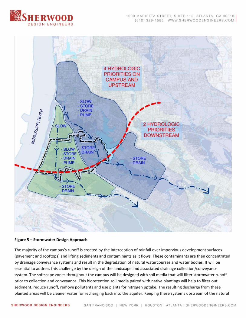
Figure 5 – Stormwater Design Approach
The majority of the campus’s runoff is created by the interception of rainfall over impervious development surfaces
(pavement and rooftops) and lifting sediments and contaminants as it flows. These contaminants are then concentrated
by drainage conveyance systems and result in the degradation of natural watercourses and water bodies. It will be
essential to address this challenge by the design of the landscape and associated drainage collection/conveyance
system. The softscape zones throughout the campus will be designed with soil media that will filter stormwater runoff
prior to collection and conveyance. This bioretention soil media paired with native plantings will help to filter out
sediment, reduce runoff, remove pollutants and use plants for nitrogen uptake. The resulting discharge from these
planted areas will be cleaner water for recharging back into the aquifer. Keeping these systems upstream of the natural

corridors will allow for higher water quality for both infiltration and discharge to the larger stormwater management
system / watershed.
As the masterplan schemes were developed the key strategies that emerged were a strong focus on maintaining existing
drainage patterns, improving existing blueway systems and developing larger greenway corridors that better define the
campus and provide a more structured approach to managing stormwater on campus. This approach will aim to
minimize impacts to existing drainage networks and improve the overall conditions of the watershed and associated
floodplain. The strategies evolve around above ground conveyances , stormwater storage and water quality nodes
located along natural greenway/blueway zones and transportation / landscape (vehicular and pedestrian) corridors.
Figure 6 – Greenway Systems
By finding these alignments, stormwater infrastructure is reduced, water quality of the stormwater runoff is improved,
user experience is enhanced and natural habitat corridors are extended. In order to move towards a more resilient
approach to future development and stormwater management a toolkit of techniques have been established based on
location and type of development. Below is a list of runoff types and the ideal approach to capture, conveyance and
treatment.
Hardscape Runoff
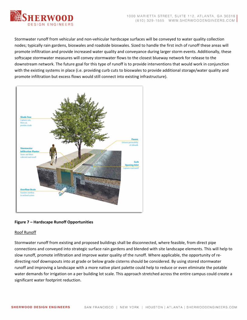
Stormwater runoff from vehicular and non‐vehicular hardscape surfaces will be conveyed to water quality collection
nodes; typically rain gardens, bioswales and roadside bioswales. Sized to handle the first inch of runoff these areas will
promote infiltration and provide increased water quality and conveyance during larger storm events. Additionally, these
softscape stormwater measures will convey stormwater flows to the closest blueway network for release to the
downstream network. The future goal for this type of runoff is to provide interventions that would work in conjunction
with the existing systems in place (i.e. providing curb cuts to bioswales to provide additional storage/water quality and
promote infiltration but excess flows would still connect into existing infrastructure).
Figure 7 – Hardscape Runoff Opportunities
Roof Runoff
Stormwater runoff from existing and proposed buildings shall be disconnected, where feasible, from direct pipe
connections and conveyed into strategic surface rain gardens and blended with site landscape elements. This will help to
slow runoff, promote infiltration and improve water quality of the runoff. Where applicable, the opportunity of re‐
directing roof downspouts into at grade or below grade cisterns should be considered. By using stored stormwater
runoff and improving a landscape with a more native plant palette could help to reduce or even eliminate the potable
water demands for irrigation on a per building lot scale. This approach stretched across the entire campus could create a
significant water footprint reduction.

Figure 8 – Roof Runoff Opportunities
Parking Lot Runoff
Parking areas used for event space and which are located within the floodplain shall be designed to handle flooding and
reduce runoff by using a combination of grass pavers and permeable pavement. The type of final cover will depend upon
the use, but switching away from conventional paved parking lots can have an important impact on water
quality/quantity, aesthetic and downstream effects. The additional benefit to traditional pavement is reduction of heat
island effect, maintenance and the opportunity to more easily dual use the space.
Figure 9 – Parking Runoff Opportunities
HMGP Projects
During the masterplan process the Baton Rouge area, including LSU’s campus experienced a significant storm event
which began on August 11th 2016. The event flooded many homes and roadways throughout the Baton Rouge area and
caused millions of dollars in damages. The area was declared a Presidential major disaster area which thus enables
FEMA to provide Hazard Mitigation Grant Funding (HMGP) toward projects that will help communities reduce or
eliminate long term risk to people and property. From Sherwood’s experience with this funding stream, we worked with
the LSU staff and the master planning team to identify three (3) projects that could integrate into the Masterplan which
could also help to benefit the communities north and south of the campus. Below is a list of the projects identified that
build upon the masterplan work;
Project 1: West Side Improvements
The west side of the LSU campus is less populated by educational buildings/facilities and rather hosts campus outdoor
sports activities, the Louisiana Animal Disease Laboratory, the LSU Agriculture Center and LSU golf course and sports
fields. An existing canal carrying runoff from the campus property and neighborhood to the north splits the west campus
in half and offers an opportunity to create floodable/dual functioning spaces that could create on and off‐site benefits.
Strategies to be employed include excavating and berming in the selected areas and deepening and/or widening specific
ponds on the golf course to increase storage for a predetermined amount of time before controlled release into the
downstream Bayou Fountain. Also, upgrading the existing canal by removing current constrictions will provide for better
conveyance efficiency during all storms.
Project 2: Corporation Canal Improvements
Project 2 consists of improvements to the Corporation Canal on the east side of campus as well as Campus Lake. In
addition to providing improved stormwater management on campus, better management of the flow through
Corporation Canal will benefit areas north and south of campus by diverting flow north of campus and storing water
from campus so areas south can drain before receiving runoff from LSU.
Strategies to be employed include installing a lift station in Corporation Canal to remove heavy flows from the canal
north of campus, widening the section of canal on campus to provide for greater storage, and deepening Campus Lake
to provide for increased storage.
The lift station proposed would be located at the East Chimes Street bridge crossing and pump water across campus
property for discharge directly into University Lake. On campus Corporation Canal and Campus Lake will be reconfigured
to provide for increased storage for a predetermined amount of time before controlled release into the downstream
Bayou Duplanier.
Project 3: University Lake Outfall Improvements
The improvements proposed during the University Lake Masterplan process made limited adjustments to flood storage
within the lake and rather focused on connectivity and edge conditions. To build upon this thinking the opportunity to
improve the lakes storage capacity was evaluated. By lowering the outfall weir elevation of University Lake the storage
capacity will be greatly enhanced. Over an area of 284 acres, one additional inch of capacity will provide for
approximately 7.5 million gallons of storage and thereby increasing pipe capacity upstream.
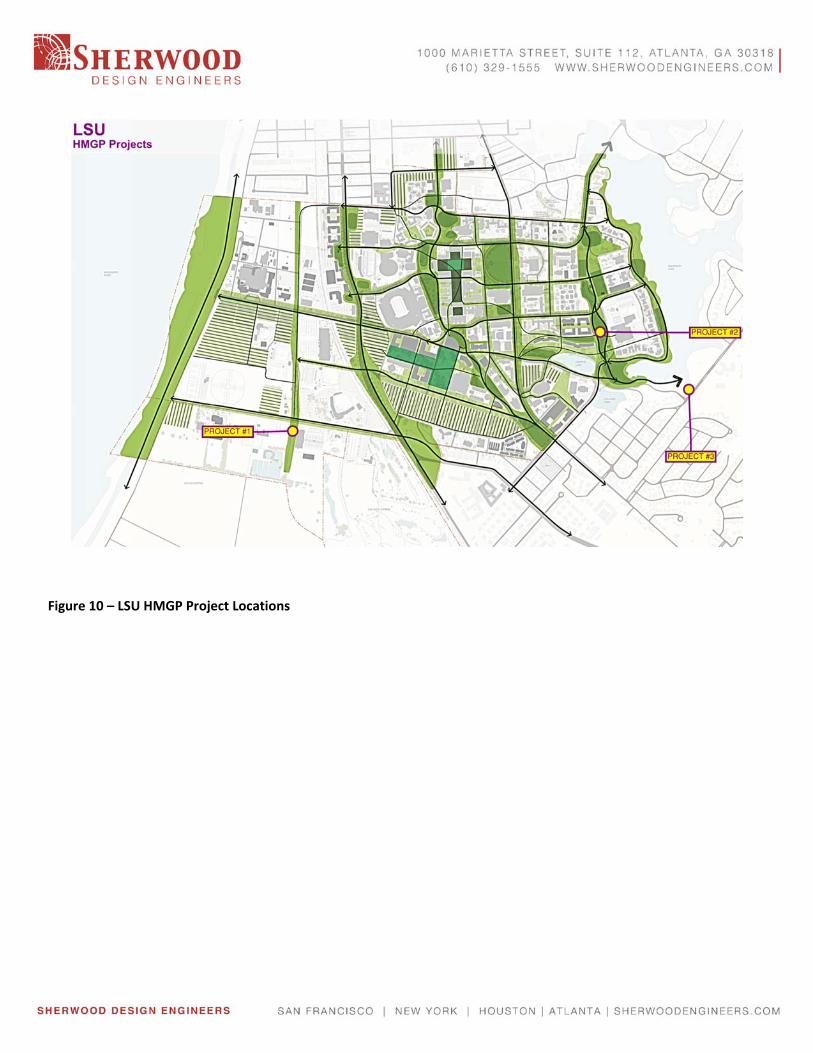
Figure 10 – LSU HMGP Project Locations

STORMWATER SOLUTIONSKIT OF PARTS
Stormwater BMPs included:• Roadside Bioswale• Gravel Diaphragm• Rain Garden• Vegetated Swale• Grass Pavers• Permeable Pavement• Floodplain Naturalization
Content
STORMWATER BMPs

ROADSIDE BIOSWALEBioswales adjacent to roadways and parkinglots capture and treat runoff, removingpollutants from the road surface includingdebris, silt, heavy metals and hydrocarbons.
4Stormwater Kit of Parts
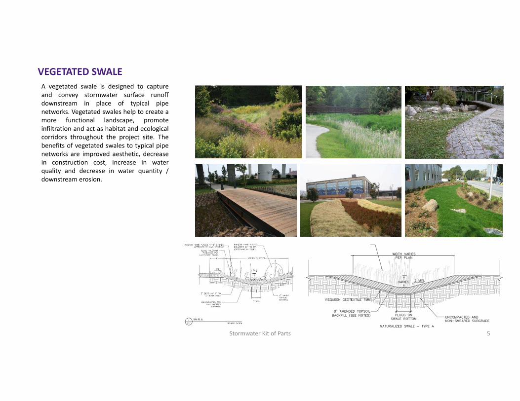
VEGETATED SWALEA vegetated swale is designed to captureand convey stormwater surface runoffdownstream in place of typical pipenetworks. Vegetated swales help to create amore functional landscape, promoteinfiltration and act as habitat and ecologicalcorridors throughout the project site. Thebenefits of vegetated swales to typical pipenetworks are improved aesthetic, decreasein construction cost, increase in waterquality and decrease in water quantity /downstream erosion.
5Stormwater Kit of Parts

GRAVEL DIAPHRAGMA gravel diaphragm is an exposed stonetrench containing a perforated pipe,bordered by vegetation on either side.Stormwater is filtered through vegetatededges prior to reaching the exposed graveldiaphragm where runoff is forced to eitherinfiltrate or collected and carrieddownstream via a perforated pipe. Thispractice helps to promote infiltration, slowflows and provide an improved aesthetic totypical curb and gutter.
6Stormwater Kit of Parts
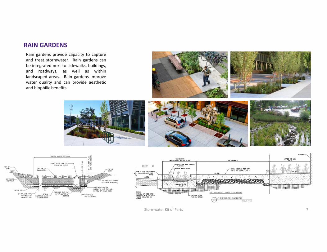
RAIN GARDENSRain gardens provide capacity to captureand treat stormwater. Rain gardens canbe integrated next to sidewalks, buildings,and roadways, as well as withinlandscaped areas. Rain gardens improvewater quality and can provide aestheticand biophilic benefits.
7Stormwater Kit of Parts
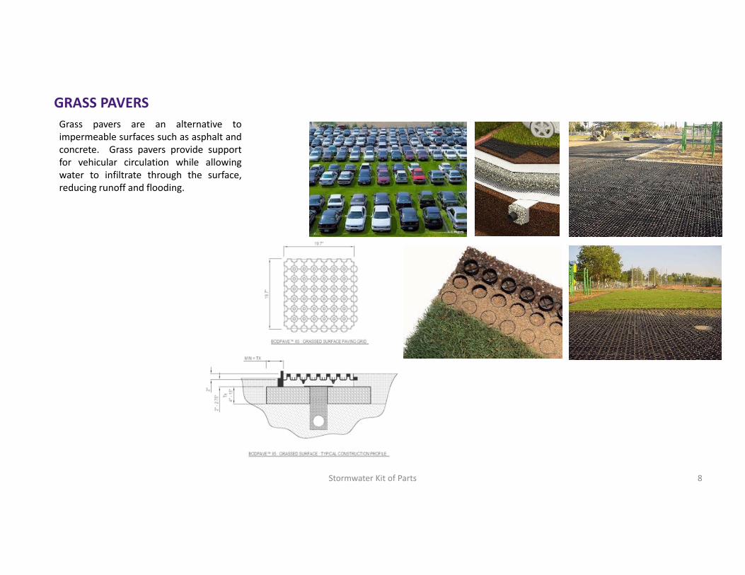
GRASS PAVERSGrass pavers are an alternative toimpermeable surfaces such as asphalt andconcrete. Grass pavers provide supportfor vehicular circulation while allowingwater to infiltrate through the surface,reducing runoff and flooding.
8Stormwater Kit of Parts
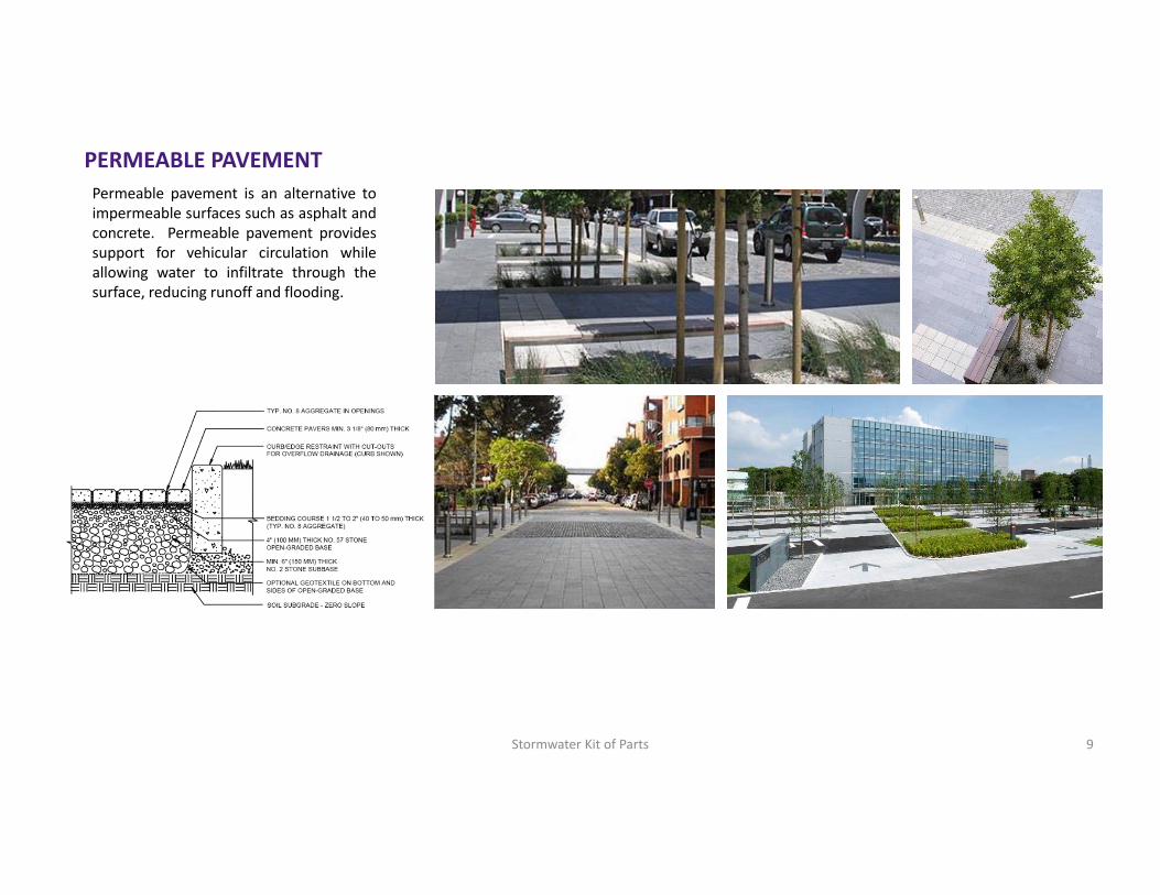
PERMEABLE PAVEMENTPermeable pavement is an alternative toimpermeable surfaces such as asphalt andconcrete. Permeable pavement providessupport for vehicular circulation whileallowing water to infiltrate through thesurface, reducing runoff and flooding.
9Stormwater Kit of Parts

FLOODPLAIN NATURALIZATIONFloodplains serve important functions ofproviding space for water when rains areheavy. Floodplains are typically low lyingplains that either infiltrate water or holdwater until it runs off. Naturalizingfloodplains is a BMP strategy to optimizethe performance of floodplains. Givingwater the space it needs while protectingdevelopment from flooding is part of anapproach to design with nature.
10Stormwater Kit of Parts

ADDITIONAL INFO

This Stormwater Kit of Parts provides information about various stormwater design elements as they apply to the LSU Master Plan.
There are many benefits of adding vegetation to a storm water system: • Planting slows down the water and helps the soil stay healthy, the roots create better infiltration and
treatment opportunities, and decomposing plant parts increase the organic matter in the soil. • The plants absorb water ‐ the larger the plant, the more water it transpires a day. • The foliage picks up a lot of the rain and delays or prevents rain from becoming runoff on the ground. • Vegetation also picks up nutrients and pollutants from the water.
• On top of all the technical benefits, vegetated stormwater solutions make the project more aesthetically pleasing compared with traditional mechanisms for treatment and quantity reduction.
Benefits of Stormwater BMPs