appendix h-7 design and construction considerations for final...
TRANSCRIPT
APPENDIX H-7 Design and Construction Considerations for Final Alternatives
2006

Salton Sea Ecosystem H7-iii 2006 Restoration Draft PEIR 062890034SAC
Table of Contents
Items Page Appendix H-7 Design and Construction Considerations for Final Alternatives ....................... H7-1 Inflows and Modeling Results ................................................................................................. H7-1 Schedule Assumptions ........................................................................................................... H7-1 Early Start Habitat................................................................................................................... H7-2 Design and Construction Considerations................................................................................ H7-3
No Action Alternative-CEQA Conditions ................................................................... H7-49 Salton Sea..................................................................................................... H7-49 Exposed Playa with Air Quality Management................................................ H7-49 Pupfish Connectivity...................................................................................... H7-50 Construction and Operations under Phases I through IV .............................. H7-50
No Action Alternative-Variability Conditions.............................................................. H7-50 Salton Sea..................................................................................................... H7-51 Exposed Playa with Air Quality Management................................................ H7-51 Pupfish Connectivity...................................................................................... H7-51 Construction and Operations under Phases I through IV .............................. H7-51
Alternative 1 – Saline Habitat Complex I................................................................... H7-51 Exposed Playa with Air Quality Management Area ....................................... H7-52 Saline Habitat Complex................................................................................. H7-52 Pupfish Connectivity...................................................................................... H7-53 Brine Sink ...................................................................................................... H7-53 Water Distribution and Conveyance.............................................................. H7-54 Construction and Operations under Phases I through IV .............................. H7-55
Alternative 2 – Saline Habitat Complex II.................................................................. H7-55 Exposed Playa with Air Quality Management................................................ H7-55 Saline Habitat Complex and Shoreline Waterway......................................... H7-55 Pupfish Connectivity...................................................................................... H7-56 Brine Sink ...................................................................................................... H7-56 Water Distribution and Conveyance.............................................................. H7-57 Construction and Operations under Phases I through IV .............................. H7-57
Alternative 3 – Concentric Rings............................................................................... H7-58 First Ring ....................................................................................................... H7-58 Second Ring.................................................................................................. H7-58 Perimeter Dike............................................................................................... H7-58 Formation of the Rings .................................................................................. H7-59 Exposed Playa with Air Quality Management................................................ H7-59 Pupfish Connectivity...................................................................................... H7-59 Brine Sink ...................................................................................................... H7-59 Water Distribution and Conveyance.............................................................. H7-59 Construction and Operations under Phases I through IV .............................. H7-60
Alternative 4 – Concentric Lakes .............................................................................. H7-60 First Lake....................................................................................................... H7-60 Second Lake ................................................................................................. H7-61 Third Lake ..................................................................................................... H7-61 Fourth Lake ................................................................................................... H7-61 Geotube® Berm.............................................................................................. H7-61 Formation of the Lakes.................................................................................. H7-62 Exposed Playa .............................................................................................. H7-62

Appendix H-7 Design and Construction Considerations for Final Alternatives
2006 H7-iv Salton Sea Ecosystem Restoration Draft PEIR
Pupfish Connectivity...................................................................................... H7-62 Brine Sink ...................................................................................................... H7-62 Water Conveyance and Distribution.............................................................. H7-63 Construction and Operations under Phases I through IV .............................. H7-63
Alternative 5 – North Sea .......................................................................................... H7-63 Marine Sea .................................................................................................... H7-63 Marine Sea Barrier ........................................................................................ H7-64 Exposed Playa with Air Quality Management................................................ H7-64 Saline Habitat Complex and Shoreline Waterway......................................... H7-64 Pupfish Connectivity...................................................................................... H7-65 Brine Sink ...................................................................................................... H7-65 Construction and Operations under Phases I through IV .............................. H7-65
Alternative 6 – Combined North Sea......................................................................... H7-66 Marine Sea and Marine Sea Mixing Zone ..................................................... H7-66 Marine Sea Barrier and Marine Sea Mixing Zone Perimeter Dike................. H7-66 Exposed Playa with Air Quality Management................................................ H7-67 Saline Habitat Complex and Shoreline Waterway......................................... H7-67 Pupfish Connectivity...................................................................................... H7-68 Brine Sink ...................................................................................................... H7-68 Construction and Operations under Phases I through IV .............................. H7-68
Alternative 7 – Combined North and South Lakes .................................................... H7-69 Recreational Saltwater Lake and Recreational Estuary Lake ....................... H7-69 Barrier and Perimeter Dike............................................................................ H7-70 Imperial Irrigation District Reservoir .............................................................. H7-70 Exposed Playa with Air Quality Management................................................ H7-70 Saline Habitat Complex................................................................................. H7-71 Water Quality Management........................................................................... H7-71 Pupfish Connectivity...................................................................................... H7-72 Brine Sink ...................................................................................................... H7-72 Construction and Operations under Phases I through IV .............................. H7-72
Alternative 8 – Combined South Sea ........................................................................ H7-72 Marine Sea .................................................................................................... H7-73 Barrier and Perimeter Dike............................................................................ H7-73 Exposed Playa with Air Quality Management................................................ H7-73 Saline Habitat Complex and Shoreline Waterway......................................... H7-74 Pupfish Connectivity...................................................................................... H7-74 Brine Sink ...................................................................................................... H7-74 Construction and Operations under Phases I through IV .............................. H7-75
Cost Estimates...................................................................................................................... H7-75
List of Tables
Items Page Table H7-1 Comparison of Infrastructure Features in Alternatives......................................... H7-4 Table H7-2 Comparison of Alternatives Descriptions by Phase ............................................. H7-6 Table H7-3 Location of Saline Habitat Complex under Alternative 1.................................... H7-53 Table H7-4 Location of Saline Habitat Complex under Alternative 2.................................... H7-56 Table H7-5 Location of Open Water in Rings under Alternative 3 ........................................ H7-59 Table H7-6 Location of Open Water in Lakes under Alternative 4........................................ H7-62

Appendix H-7 Design and Construction Considerations for Final Alternatives
Salton Sea Ecosystem H7-v 2006 Restoration Draft PEIR
Table H7-7 Location of Saline Habitat Complex under Alternative 5.................................... H7-65 Table H7-8 Location of Saline Habitat Complex under Alternative 6.................................... H7-68 Table H7-9 Location of Saline Habitat Complex under Alternative 7.................................... H7-71 Table H7-10 Location of Saline Habitat Complex under Alternative 8.................................. H7-74 Table H7-11 Preliminary Capital and Operations and Maintenance Cost Estimates............ H7-76 Table H7-12 Preliminary Capital Cost Estimates for No Action Alternative .......................... H7-79 Table H7-13 Preliminary Capital Cost Estimates for Alternative 1........................................ H7-81 Table H7-14 Preliminary Capital Cost Estimates for Alternative 2........................................ H7-84 Table H7-15 Preliminary Capital Cost Estimates for Alternative 3........................................ H7-86 Table H7-16 Preliminary Capital Cost Estimates for Alternative 4........................................ H7-88 Table H7-17 Preliminary Capital Cost Estimates for Alternative 5........................................ H7-90 Table H7-18 Preliminary Capital Cost Estimates for Alternative 6........................................ H7-93 Table H7-19 Preliminary Capital Cost Estimates for Alternative 7........................................ H7-96 Table H7-20 Preliminary Capital Cost Estimates for Alternative 8........................................ H7-99
List of Figures
Items Page Figure H7-1 A Phase 1 (2002) No Action Alternative CEQA Conditions .................... H7-9 Figure H7-1 B Phase 2 (2030) No Action Alternative CEQA Conditions .................... H7-9 Figure H7-1 C Phase 3 (2040) No Action Alternative CEQA Conditions .................. H7-11 Figure H7-1 D Phase 4 (2078) No Action Alternative CEQA Condtions ................... H7-11 Figure H7-2 A Phase 1 (2020) No Action Alternative Variability Conditions ............. H7-13 Figure H7-2 B Phase 2 (2030) No Action Alternative Variability Conditions ............. H7-13 Figure H7-2 C Phase 3 (2040) No Action Alternative Variability Conditions ............. H7-15 Figure H7-2 D Phase 4 (2078) No Action Alternative Variability Conditions ............. H7-15 Figure H7-3 A Phase 1 (2020) Alternative 1 Saline Habitat Complex I..................... H7-17 Figure H7-3 B Phase 2 (2030) Alternative 1 Saline Habitat Complex I..................... H7-17 Figure H7-3 C Phase 3 (2040) Alternative 1 Saline Habitat CompleX I .................... H7-19 Figure H7-3 D PhAse 4 (2078) Alternative 1 Saline Habitat Complex I .................... H7-19 Figure H7-4 A Phase 1 (2020) Alternative 2 Saline Habitat Complex II.................... H7-21 Figure H7-4 B Phase 2 (2030) Alternative 2 Saline Habitat Complex II.................... H7-21 Figure H7-4 C Phase 3 (2040) Alternative 2 Saline Habitat Complex II.................... H7-23 Figure H7-4 D Phase 4 (2078) Alternative 2 Saline Habitat Complex II.................... H7-23 Figure H7-5 A Phase 1 (2020) Alternative 3 Concentric Rings................................. H7-25 Figure H7-5 B Phase 2 (2030) Alternative 3 Concentric Rings................................. H7-25 Figure H7-5 C Phase 3 (2040) Alternative 3 Concentric Rings................................. H7-27 Figure H7-5 D Phase 4 (2078) Alternative 3 Concentric Rings................................. H7-27 Figure H7-6 A Phase 1 (2020) Alternative 4 Concentric Lakes ................................ H7-29 Figure H7-6 B Phase 2 (2030) Alternative 4 Concentric Lakes ................................ H7-29 Figure H7-6 C Phase 3 (2040) Alternative 4 Concentric Lakes ................................ H7-31 Figure H7-6 D Phase 4 (2078) Alternative 4 Concentric Lakes ................................ H7-31 Figure H7-7 A Phase 1 (2020) Alternative 5 North Sea............................................ H7-33 Figure H7-7 B Phase 2 (2030) Alternative 5 North Sea............................................ H7-33 Figure H7-7 C Phase 2 (2040) Alternative 5 North Sea............................................ H7-35 Figure H7-7 D Phase 4 (2078) Alternative 5 North Sea............................................ H7-35 Figure H7-8 A Phase 2 (2020) Alternative 6 North Sea Combined........................... H7-37 Figure H7-8 B Phase 2 (2030) Alternative 6 North Sea Combined........................... H7-37 Figure H7-8 C Phase 3 (2040) Alternative 6 North Sea Combined........................... H7-39

Appendix H-7 Design and Construction Considerations for Final Alternatives
2006 H7-vi Salton Sea Ecosystem Restoration Draft PEIR
Figure H7-8 D Phase 4 (2078) Alternative 6 North Sea Combined........................... H7-39 Figure H7-9 A Phase 1 (2020) Alternative 7 Combined North and South Lakes ...... H7-41 Figure H7-9 B Phase 2 (2030) Alternative 7 Combined North and South Lakes ...... H7-41 Figure H7-9 C Phase 3 (2040) Alternative 7 Combined North and South Lakes ...... H7-43 Figure H7-9 D Phase 4 (2078) Alternative 7 Combined North and South Lakes ...... H7-43 Figure H7-10 A Phase 1 (2020) Alternative 8 South Sea Combined .......................... H7-45 Figure H7-10 B Phase 2 (2030) Alternative 8 South Sea Combined .......................... H7-45 Figure H7-10 C Phase 3 (2040) Alternative 8 South Sea Combined .......................... H7-47 Figure H7-10 D Phase 4 (2078) Alternative 8 South Sea Combined .......................... H7-47
Salton Sea Ecosystem H7-1 2006 Restoration Draft PEIR
APPENDIX H-7 DESIGN AND CONSTRUCTION CONSIDERATIONS
FOR FINAL ALTERNATIVES This appendix describes the proposed layouts, construction issues, and operations and maintenance requirements for the alternatives evaluated in detail in the Draft Programmatic Environmental Impact Report (PEIR). The criteria developed for the components and facilities are described in Appendix H-6. The final range of alternatives (Alternatives 1 through 8) was developed through a multiple-step screening process, as described in Chapter 2 of the PEIR. This appendix describes assumptions related to inflows, schedule, Early Start Habitat; construction and operations and maintenance, and costs of Alternatives 1 through 8 and the No Action Alternative.
INFLOWS AND MODELING RESULTS As described in Appendix H-2, a range of inflows was analyzed to determine the inflow patterns over the study period. Analysis of each alternative for multiple inflow assumptions was considered. However, it was determined that for the purposes of the PEIR, one set of inflows would be used to define the sizes of facilities and another set of inflows would be used to evaluate conditions that would occur for implementation of the alternatives.
Sizing of the Marine Seas and Saline Habitat Complex areas in the alternatives were based upon an average inflow of 650,000 acre-feet/year. This was defined as the 80 percentile in the stochastic analysis of inflows for the period from 2018 through 2078, using the SALSA model and the Monte Carlo statistical analyses. These analyses are described in Appendix H-2.
Surface water elevations, volumes, and salinity were defined for the alternatives using the average inflow of 717,000 acre-feet/year. This was defined as the median in the stochastic analysis described above for the period from 2018 through 2078. This also was defined as the basis of the No Action Alternative-Variability Conditions.
Appendix H-2 includes the results of the stochastic analyses for surface water elevations and salinity based upon operations of the alternatives for the range of inflows and for specific average inflow scenarios of 600,000, 700,000, 800,000, and 900,000 acre-feet/year.
SCHEDULE ASSUMPTIONS Using the SALSA model, an operations simulation was developed for each alternative based upon an assumed construction schedule. The schedules were based on the assumption that the alternatives could be funded, designed, and permitted in a reasonable time period following the selection of a preferred alternative. For all alternatives, it was assumed that initiation of a project-level analysis could occur as early as 2008. This would allow time for the California Legislature to review the Final PEIR and select a preferred alternative. This analysis does not include specific assumptions related to the implementing agency or methods to make funding available.
The schedule assumes concurrent completion of project-level engineering design and analysis, environmental documents, right-of-way acquisition, funding authorizations, air quality management plan approvals, and permitting. However, it is recognized that the actual schedule for the preferred alternative would be developed during project-level analysis and may be implemented by multiple entities. The following assumptions were used in this analysis for pre-construction activities:
• PEIR completed by mid-2007;

Appendix H-7 Design and Construction Considerations for Final Alternatives
2006 H7-2 Salton Sea Ecosystem Restoration Draft PEIR
• Preferred alternative approved by the Legislature by late 2007;
• Implementing agencies and funding identified by late 2007;
• Project-level analyses and environmental documentation completed by 2010 (including detailed field investigations of geotechnical and chemical characteristics of sediment, bathymetry, and water quality characteristics);
• Final design completed by 2012;
• Permits, approvals, and easements or deeds obtained by 2013; and
• Major construction initiated by 2014 following a one-year construction bid period.
The study period was divided into four phases. Phase I (2006 to 2020) represents the period with most of the construction activity for large facilities such as Barriers, Air Quality Management Canals, and Sedimentation/Distribution Basins. During Phases II and III (2020 to 2030 and 2030 to 2040, respectively), construction would continue in the Sea Bed as the water recedes and operations and maintenance activities would be initiated for previously constructed facilities. During Phase IV (2040 to 2078), operations and maintenance activities would continue for all facilities and additional Air Quality Management actions would be completed if portions of the Exposed Playa become emissive.
The construction schedule for each alternative is based on a number of simplifying assumptions. Alternatives that include the construction of major rock Barriers or Perimeter Dikes (Alternatives 3, 5, 6, 7, and 8) would likely take longer to implement than alternatives that use primarily Sea Bed materials (Alternatives 1, 2, and 4). This is because Barrier and Perimeter Dike alternatives would require large quantities of imported materials and difficult handling techniques to place the material. Production rates for placing these rocks and gravels would be dependent on transport methods, equipment limitations, quarry locations and operations, and method of rock placement. There also could be constraints required by permitting agencies, such as limits on activities that cause air quality degradation or restrictions on building harbors where rock would be transferred from land transport vehicles to barges. Despite these uncertainties, the final alternative schedules assumed that Barrier and Perimeter Dike alternatives could be constructed and operational when major inflow reductions are projected to occur (2018 to early 2020s). The Barrier completion schedule influences the time in which the salinity in the Marine Sea would be reduced to less than 40,000 mg/L and biological benefits could occur.
A standardized schedule for initial construction in Phase I was developed for comparative purposes between alternatives. For example, construction schedules for alternatives with Barriers and Perimeter Dikes were based on rock production rates of 20,000,000 cubic yards/year and a 5 year period to place the majority of rock to form the Barrier and Perimeter Dikes.
Following Phase I, individual construction schedules were developed for each alternative based on the projected rate of water recession and reasonable construction periods for subsequent components that could not be constructed until the water receded to specific elevations. For example, construction of a second course of Saline Habitat Complex cells would not be implemented until the water receded below the down gradient Berm location. Then, a two-year construction period was assumed until that course of Saline Habitat Complex cells was operational. These construction schedules were included in the SALSA model for each alternative to simulate the salinity and water surface elevation patterns over the study period.
EARLY START HABITAT All eight alternatives would include up to 2,000 acres of shallow saline habitat for use by birds after the Salton Sea salinity becomes too high to sustain some species. This habitat would be constructed prior to construction of full-scale habitat components, and is referred to as Early Start Habitat. Early Start Habitat was assumed to be located at elevations between -228 and -232 feet msl. Early Start Habitat would be a

Appendix H-7 Design and Construction Considerations for Final Alternatives
Salton Sea Ecosystem H7-3 2006 Restoration Draft PEIR
temporary feature for two to six years and would be eliminated or assimilated as the alternatives are constructed along the southern shoreline prior to 2020. These lands could subsequently be used for other purposes, including geothermal development, agriculture, and open space.
For the purposes of the PEIR, it was assumed that the Early Start Habitat area would be located along the southern shoreline because the flat slope of the sea bed would provide a large area for the shallow water cells. The area is currently used by many birds. Most agricultural drains in this area are pumped into the Salton Sea and could provide a stable source of inflows into the Early Start Habitat. Saline water from the Salton Sea would be pumped into the cells to be mixed with freshwater from the drains to provide salinity between 20,000 and 60,000 mg/L.
The area would be divided into cells with berms excavated from sea bed materials. Average water depths within each cell would be less than four feet. Temperatures outside the tolerance range of fish, such as tilapia, could cause fish kills or reduce their sustainability. Specific design criteria would be developed in a project-level analysis that could incorporate findings from the U.S. Department of the Interior, Geological Survey (USGS) Salton Sea Shallow Water Habitat Pilot Project.
The Early Start Habitat would require completion of additional studies, environmental documentation, permit applications, and deeds or easements for the land. It is assumed that the Early Start Habitat could be implemented before 2011 if easements or deeds could be acquired.
DESIGN AND CONSTRUCTION CONSIDERATIONS This section describes the assumed features for each alternative evaluated in the PEIR. These assumptions were developed for the purposes of comparing alternatives. During project-level analysis, it is assumed that more detailed analyses would be conducted for specific criteria. For example, the alternatives described in the PEIR assume a water surface elevation of -230 feet mean sea level (msl) for components located near the shoreline. The project-level analysis may consider several elevations based upon specific land uses along the shoreline or in the Sea Bed or on more current inflow projections. Several project-level analyses could be completed over the study period to consider if facilities to be constructed in the 2030s would be appropriate based upon monitoring information collected during the first 20 years following implementation.
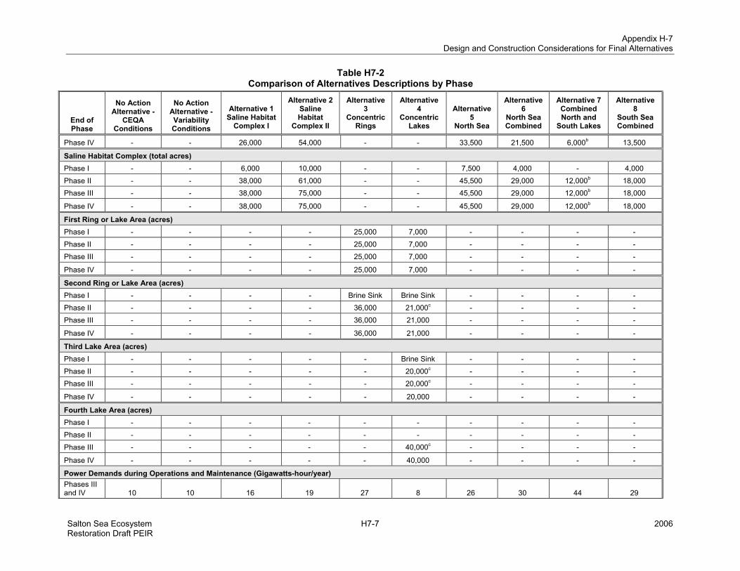
The components in each alternative are summarized in Table H7-1. Results from the SALSA model defined the salinity, surface area, and water surface elevation for each of the components. Because the inflows change over the study period, it was necessary to consider the changes in these characteristics throughout the four phases. The characteristics were calculated as values at the end of each phase, as summarized in Table H7-2. With respect to the No Action Alternative, information was provided only for No Action Alternative-Variability Conditions in Table H7-2 because this was the information used to develop the cost estimates.
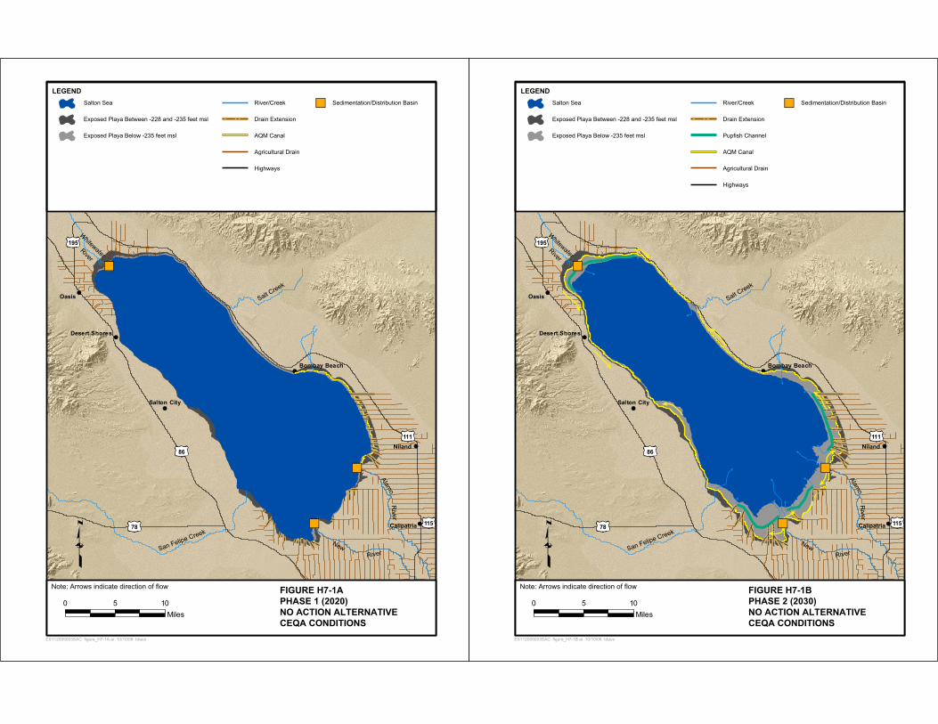
Graphic representations of the locations of components for each phase of the alternatives are presented in Figures H7-1 through H7-10. Information represented in these figures is based upon results from the SALSA model at the end of each phase.
The following description of design and construction considerations for each alternative include information related to salinity, surface water elevation and area; Barrier, Perimeter Dike, and Berm criteria; elevation and salinity control methods; Water Treatment; desert pupfish connectivity; Air Quality Management; Saline Habitat Complex; and Brine Sink.

Appendix H-7 Design and Construction Considerations for Final Alternatives
2006 H7-4 Salton Sea Ecosystem Restoration Draft PEIR
Table H7-1 Comparison of Infrastructure Features in Alternatives
Alternatives
Component No Action Alternative -
CEQA Conditions
No Action Alternative - Variability Conditions
Alternative 1
Saline Complex Habitat I
Alternative 2
Saline Habitat
Complex II
Alternative 3
Concentric Rings
Alternative 4 Concentric
Lakes
Alternative 5
North Sea
Alternative 6
North Sea Combined
Alternative 7
Combined North and
South Lakes
Alternative 8South Sea Combined
Air Quality Management Canals and Pumping plants
92 miles 19 pumping
plants
92 miles 19
pumping plants
88 miles 28 pumping
plants
73 miles 30 pumping
plants
78 miles 34 pumping
plants
251 miles of temporary irrigation
52 miles 32 pumping
plants
55 miles 35 pumping
plants -
79 miles 42 pumping
plants
Pupfish Channel 30 miles 30 miles 30 miles - - - - 10 miles - -
Marine Sea Recirculation Canal and Pumping plant
- - - - 1 pumping plant -
20 miles 1 pumping
plant
28 miles 1 pumping
plant
20 miles 1 pumping
plant
17 miles 1 pumping
plant
Deep Marine Sea and Moderately Deep Marine Sea
- - - - 61,000 acres - 62,000
acres 74,000 acres
104,000 acres 83,000 acres
Saline Habitat Complex Component - - 38,000
acres 75,000 acres - 45,500
acres 29,000 acres
12,000 acres 18,000 acres
Concentric Lakes - Similar to Saline Habitat Complex without separate cells and wide range of salinity
88,000 acres
Salton Sea or Brine Sink at 2078
172,000 acres
140,000 acres
123,000 acres
85,000 acres
68,000 acres 22,000 acres 13,000
acres 11,000 acres
15,000 acres 9,000 acres
Sedimentation and Distribution Basins
3 basins of 200 acres
each
3 basins of 200 acres
each
3 basins of 200 acres
each
3 basins of 200 acres
each
2 basins of 200 acres
each
2 basins of 200 acres
each
2 basins of 200 acres
each
1 basin of 200 acres
1 basin of 200 acres
2 basins of 200 acres
each Air Quality Management with water efficient vegetation
24,000 acres 24,000 acres
41,000 acres 46,000 acres 63,000
acres - 59,000 acres
66,000 acres - 64,000 acres
Air Quality Management with Brine Stabilization
9,000 acres 9,000 acres 17,000 acres 18,000 acres 26,000
acres - 24,000 acres
26,000 acres
66,500 acres 26,000 acres

Appendix H-7 Design and Construction Considerations for Final Alternatives
Salton Sea Ecosystem H7-5 2006 Restoration Draft PEIR
Table H7-1 Comparison of Infrastructure Features in Alternatives
Alternatives
Component No Action Alternative -
CEQA Conditions
No Action Alternative - Variability Conditions
Alternative 1
Saline Complex Habitat I
Alternative 2
Saline Habitat
Complex II
Alternative 3
Concentric Rings
Alternative 4 Concentric
Lakes
Alternative 5
North Sea
Alternative 6
North Sea Combined
Alternative 7
Combined North and
South Lakes
Alternative 8South Sea Combined
Imperial Irrigation District Reservoir - - - - - - - - 11,000
acres -
Treatment Plants - - - - - - - - 2 -
Volume of imported rock and gravel
1,680,000 cubic yards
1,680,000 cubic yards
6,720,000 cubic yards
11,670,000 cubic yards
85,150,000 cubic yards
7,420,000 cubic yards
53,730,000 cubic yards
93,650,000 cubic yards
79,650,000 cubic yards
100,270,000 cubic yards
Volume of Sea Bed soils excavated or dredged
5,050,000 cubic yards
5,050,000 cubic yards
77,140,000 cubic yards
136,530,000 cubic yards
18,810,000 cubic yards
154,215,000 cubic yards
86,770,000 cubic yards
66,970,000 cubic yards
33,522,000 cubic yards
47,230,000 cubic yards
Trucks to import rock and gravel per day during peak construction periods
4 4 50 100 1,200 90 1,400 2,500 2,200 2,700
Employees per day during peak construction period (does not include drivers of trucks in previous row of this table)
500 500 1,000 1,500 1,500 1,500 1,500 2,000 2,000 2,000
Employees per day during operations and maintenance
100 100 200 300 300 25 300 350 200 300
Energy demand during operations and maintenance
10 Gigawatt-hour/year
10 Gigawatt-hour/year
16 Gigawatt-hour/year
19 Gigawatt-hour/year
27 Gigawatt-hour/year
8 Gigawatt-hour/year
26 Gigawatt-hour/year
30 Gigawatt-hour/year
44 Gigawatt-hour/year
29 Gigawatt-hour/year
Notes: - = component not included

Appendix H-7 Design and Construction Considerations for Final Alternatives
2006 H7-6 Salton Sea Ecosystem Restoration Draft PEIR
Table H7-2 Comparison of Alternatives Descriptions by Phase
End of Phase
No Action Alternative -
CEQA Conditions
No Action Alternative - Variability Conditions
Alternative 1 Saline Habitat
Complex I
Alternative 2 Saline Habitat
Complex II
Alternative 3
Concentric Rings
Alternative 4
Concentric Lakes
Alternative 5
North Sea
Alternative 6
North Sea Combined
Alternative 7 Combined North and
South Lakes
Alternative 8
South Sea Combined
Brine Sink Salinity (mg/L) (includes Salton Sea under No Action Alternative) Phase I 65,000 76,000 78,000 78,000 88,000 79,000 76,000 76,000 76,000 76,000 Phase II 103,000 164,000 210,000 249,000 >350,000 299,000 >350,000 >350,000 >350,000 >350,000 Phase III 129,000 249,000 >350,000 >350,000 >350,000 >350,000 >350,000 >350,000 >350,000 >350,000
Phase IV 138,000 308,000 >350,000 >350,000 >350,000 >350,000 >350,000 >350,000 >350,000 >350,000
Maximum Brine Sink Elevation (feet msl) (includes Salton Sea under No Action Alternative) Phase I -236 -240 -241 -241 -244 -240 -240 -240 -240 -240 Phase II -245 -254 -257 -259 -267 -260 -270 -270 -272 -274 Phase III -248 -259 -264 -269 -273 -271 -275 -276 -273 -277
Phase IV -248 -260 -264 -271 -273 -276 -276 -276 -273 -277
Brine Sink Area (acres) (includes Salton Sea under No Action Alternative) Phase I 217,000 208,000 207,000 207,000 166,000 202,000 207,000 207,000 208,000 207,000 Phase II 186,000 159,000 149,000 144,000 115,000 132,000 68,000 72,000 28,000 62,000 Phase III 172,000 143,000 127,000 105,000 68,000 71,000 14,000 11,000 15,000 9,000
Phase IV 172,000 140,000 123,000 85,000 68,000 22,000 13,000 11,000 15,000 9,000
Exposed Playa (acres) (includes Air Quality Management areas) Phase I 4,000 16,000 30,000 30,000 6,000 12,000 30,000 30,000 30,000 30,000 Phase II 36,000 63,000 57,000 34,000 65,000 40,000 73,000 86,000 89,000 96,000 Phase III 48,000 78,000 72,000 63,000 123,000 66,000 115,000 130,000 92,000 128,000
Phase IV 48,000 81,000 77,000 91,000 127,000 111,000 117,000 131,000 97,000 128,000
Marine Sea and Marine Sea Mixing Zone (acres) (includes Recreational Saltwater and Recreational Estuary Lakes in Alternative 7) Phase I - - - - - - Brine Sink Brine Sink Brine Sink Brine Sink Phase II - - - - - - 62,000 74,000 104,000a 83,000 Phase III - - - - - - 62,000 74,000 104,000 83,000
Phase IV - - - - - - 62,000 74,000 104,000 83,000
Saline Habitat Complex (wetted acres) (including Shoreline Waterways) Phase I - - 4,000 10,000 - - 7,500 4,000 - 4,000 Phase II - - 26,000 42,000 - - 33,500 21,500 6,000b 13,500 Phase III - - 26,000 54,000 - - 33,500 21,500 6,000b 13,500
Appendix H-7 Design and Construction Considerations for Final Alternatives
Salton Sea Ecosystem H7-7 2006 Restoration Draft PEIR
Table H7-2 Comparison of Alternatives Descriptions by Phase
End of Phase
No Action Alternative -
CEQA Conditions
No Action Alternative - Variability Conditions
Alternative 1 Saline Habitat
Complex I
Alternative 2 Saline Habitat
Complex II
Alternative 3
Concentric Rings
Alternative 4
Concentric Lakes
Alternative 5
North Sea
Alternative 6
North Sea Combined
Alternative 7 Combined North and
South Lakes
Alternative 8
South Sea Combined
Phase IV - - 26,000 54,000 - - 33,500 21,500 6,000b 13,500
Saline Habitat Complex (total acres) Phase I - - 6,000 10,000 - - 7,500 4,000 - 4,000 Phase II - - 38,000 61,000 - - 45,500 29,000 12,000b 18,000 Phase III - - 38,000 75,000 - - 45,500 29,000 12,000b 18,000
Phase IV - - 38,000 75,000 - - 45,500 29,000 12,000b 18,000
First Ring or Lake Area (acres) Phase I - - - - 25,000 7,000 - - - - Phase II - - - - 25,000 7,000 - - - - Phase III - - - - 25,000 7,000 - - - -
Phase IV - - - - 25,000 7,000 - - - -
Second Ring or Lake Area (acres) Phase I - - - - Brine Sink Brine Sink - - - - Phase II - - - - 36,000 21,000c - - - - Phase III - - - - 36,000 21,000 - - - -
Phase IV - - - - 36,000 21,000 - - - -
Third Lake Area (acres) Phase I - - - - - Brine Sink - - - - Phase II - - - - - 20,000c - - - - Phase III - - - - - 20,000c - - - -
Phase IV - - - - - 20,000 - - - -
Fourth Lake Area (acres) Phase I - - - - - - - - - - Phase II - - - - - - - - - - Phase III - - - - - 40,000c - - - -
Phase IV - - - - - 40,000 - - - -
Power Demands during Operations and Maintenance (Gigawatts-hour/year) Phases III and IV 10 10 16 19 27 8 26 30 44 29

Appendix H-7 Design and Construction Considerations for Final Alternatives
2006 H7-8 Salton Sea Ecosystem Restoration Draft PEIR
Table H7-2 Comparison of Alternatives Descriptions by Phase
End of Phase
No Action Alternative -
CEQA Conditions
No Action Alternative - Variability Conditions
Alternative 1 Saline Habitat
Complex I
Alternative 2 Saline Habitat
Complex II
Alternative 3
Concentric Rings
Alternative 4
Concentric Lakes
Alternative 5
North Sea
Alternative 6
North Sea Combined
Alternative 7 Combined North and
South Lakes
Alternative 8
South Sea Combined
Imported Gravel and Rock (cubic yards) Phases I and II 1,680,000 1,680,000 6,720,000 11,670,000 85,150,000 7,420,000 53,730,000 93,650,000 79,650,000 100,270,000
Disturbed Area on Exposed Playa (acres) Phases I and II 35,800 35,800 136,700 206,400 155,450 96,950 230,450 224,250 131,950 209,550
Excavated and Dredged Soils on Sea Bed (cubic yards) Phases I and II 5,050,000 5,050,000 77,140,000 136,530,000 18,810,000 154,215,000 86,770,000 66,970,000 33,522,000 47,230,000
Trucks to Transport Gravel and Rock during Peak Construction Period (trucks/day) Phases I and II 4 4 50 100 1,200 90 1,400 2,500 2,200 2,700
Employees during Peak Construction Period (employees/day) Phases I and II 500 500 1,000 1,500 1,500 1,500 1,500 2,000 2,000 2,000
Employees during Operations and Maintenance Period (employees/day) Phases III and IV 100 100 200 300 300 25 300 350 200 300
Note All values presented in this table assume average inflows of 717,000 acre-feet/year as described under the No Action Alternative-Variability Conditions. a This water body would be formed through the completion of the Barrier at this time, however, salinity would be greater than 40,000 mg/L for the entire range of inflows. If
average inflows would be 800,000 acre-feet/year or higher, water surface area would be about 115,000 acres. b Does not include 1,600 acres of Saline Habitat Complex formed by displacement dike in Recreational Saltwater Lake near confluence with Whitewater River. The 1,600 acres
is included as part of Marine Sea/Recreational Saltwater Lake c These water bodies would be formed through the completion of Berms at this time, however, salinity would be greater than 40,000 mg/L
Salt Creek
River
Whitewater
San Felipe CreekNew
RiverAlam
oR
iver
111
78
195
115
86
D
Oasis
esert Shores
Salton City
Bombay Beach
Niland
Calipatria
Westmorland
LEGEND
ES112005003SAC figure_H7-1A.ai 10/10/06 tdaus
0 105Miles
FIGURE H7-1A
PHASE 1 (2020)
NO ACTION ALTERNATIVE
CEQA CONDITIONS
Salton Sea
Exposed Playa Between -228 and -235 feet msl
Exposed Playa Below -235 feet msl
River/Creek
Drain Extension
AQM Canal
Agricultural Drain
Highways
Sedimentation/Distribution Basin
Note: Arrows indicate direction of flow
Salt Creek
River
Whitewater
San Felipe CreekNew
River
Alamo
River
111
78
195
115
86
D
Oasis
esert Shores
Salton City
Bombay Beach
Niland
Calipatria
Westmorland
LEGEND
ES112005003SAC figure_H7-1B.ai 10/10/06 tdaus
0 105Miles
FIGURE H7-1B
PHASE 2 (2030)
NO ACTION ALTERNATIVE
CEQA CONDITIONS
Salton Sea
Exposed Playa Between -228 and -235 feet msl
Exposed Playa Below -235 feet msl
River/Creek
Drain Extension
Pupfish Channel
AQM Canal
Agricultural Drain
Highways
Sedimentation/Distribution Basin
Note: Arrows indicate direction of flow

Salt Creek
River
Whitewater
San Felipe CreekNew
RiverAlam
oR
iver
111
78
195
115
86
D
Oasis
esert Shores
Salton City
Bombay Beach
Niland
Calipatria
Westmorland
LEGEND
ES112005003SAC figure_H7-1C.ai 10/10/06 tdaus
0 105Miles
FIGURE H7-1C
PHASE 3 (2040)
NO ACTION ALTERNATIVE
CEQA CONDITIONS
Salton Sea
Exposed Playa Between -228 and -235 feet msl
Exposed Playa Below -235 feet msl
River/Creek
Drain Extension
Pupfish Channel
AQM Canal
Agricultural Drain
Highways
Sedimentation/Distribution Basin
Note: Arrows indicate direction of flow
Salt Creek
River
Whitewater
San Felipe CreekNew
River
Alamo
River
111
78
195
115
86
D
Oasis
esert Shores
Salton City
Bombay Beach
Niland
Calipatria
Westmorland
LEGEND
ES112005003SAC figure_H7-1D.ai 10/10/06 tdaus
0 105Miles
FIGURE H7-1D
PHASE 4 (2078)
NO ACTION ALTERNATIVE
CEQA CONDITIONS
Salton Sea
Exposed Playa Between -228 and -235 feet msl
Exposed Playa Below -235 feet msl
River/Creek
Drain Extension
Pupfish Channel
AQM Canal
Agricultural Drain
Highways
Sedimentation/Distribution Basin
Note: Arrows indicate direction of flow

Salt Creek
River
Whitewater
San Felipe CreekNew
RiverAlam
oR
iver
111
78
195
115
86
D
Oasis
esert Shores
Salton City
Bombay Beach
Niland
Calipatria
Westmorland
LEGEND
ES112005003SAC figure_H7-2A.ai 10/10/06 tdaus
0 105Miles
FIGURE H7-2A
PHASE 1 (2020)
NO ACTION ALTERNATIVE
VARIABILITY CONDITIONS
Salton Sea
Exposed Playa Between -228 and -235 feet msl
Exposed Playa Between -235 and -249 feet msl
River/Creek
Drain Extension
AQM Canal
Agricultural Drains
Highways
Sedimentation/Distribution Basin
Note: Arrows indicate direction of flow
Salt Creek
River
Whitewater
San Felipe CreekNew
River
Alamo
River
111
78
195
115
86
D
Oasis
esert Shores
Salton City
Bombay Beach
Niland
Calipatria
Westmorland
LEGEND
ES112005003SAC figure_H7-2B.ai 10/10/06 tdaus
0 105Miles
FIGURE H7-2B
PHASE 2 (2030)
NO ACTION ALTERNATIVE
VARIABILITY CONDITIONS
Salton Sea
Exposed Playa Between -228 and -235 feet msl
Exposed Playa Between -235 and -249 feet msl
Exposed Playa Below -249 feet msl
River/Creek
Drain Extension
Pupfish Channel
AQM Canal
Agricultural Drains
Highways
Sedimentation/Distribution Basin
Note: Arrows indicate direction of flow

Salt Creek
River
Whitewater
San Felipe CreekNew
RiverAlam
oR
iver
111
78
195
115
86
D
Oasis
esert Shores
Salton City
Bombay Beach
Niland
Calipatria
Westmorland
LEGEND
ES112005003SAC figure_H7-2C.ai 10/10/06 tdaus
0 105Miles
FIGURE H7-2C
PHASE 3 (2040)
NO ACTION ALTERNATIVE
VARIABILITY CONDITIONS
Salton Sea
Exposed Playa Between -228 and -235 feet msl
Exposed Playa Between -235 and -249 feet msl
Exposed Playa Below -249 feet msl
River/Creek
Drain Extension
Pupfish Channel
AQM Canal
Agricultural Drains
Highways
Sedimentation/Distribution Basin
Note: Arrows indicate direction of flow
Salt Creek
River
Whitewater
San Felipe CreekNew
River
Alamo
River
111
78
195
115
86
D
Oasis
esert Shores
Salton City
Bombay Beach
Niland
Calipatria
Westmorland
LEGEND
ES112005003SAC figure_H7-2D.ai 10/10/06 tdaus
0 105Miles
FIGURE H7-2D
PHASE 4 (2078)
NO ACTION ALTERNATIVE
VARIABILITY CONDITIONS
Salton Sea
Exposed Playa Between -228 and -235 feet msl
Exposed Playa Between -235 and -249 feet msl
Exposed Playa Below -249 feet msl
River/Creek
Drain Extension
Pupfish Channel
AQM Canal
Agricultural Drains
Highways
Sedimentation/Distribution Basin
Note: Arrows indicate direction of flow

Salt Creek
River
Whitewater
San Felipe CreekNew
RiverAlam
oR
iver
111
78
195
115
86
D
Oasis
esert Shores
Salton City
Bombay Beach
Niland
Calipatria
Westmorland
LEGEND
ES112005003SAC figure_H7-3A.ai 10/10/06 tdaus
0 105Miles
FIGURE H7-3A
PHASE 1 (2020)
ALTERNATIVE 1
SALINE HABITAT COMPLEX I
Saline Habitat Complex
Explosed Playa
Brine Sink
River/Creek
Highways
Agricultural Drain
AQM Canal*
Pupfish Channel*
Sedimentation/Distribution Basin
* Canal also supplies water to SHCNote: Arrows indicate direction of flow
Salt Creek
River
Whitewater
San Felipe CreekNew
River
Alamo
River
111
78
195
115
86
D
Oasis
esert Shores
Salton City
Bombay Beach
Niland
Calipatria
Westmorland
LEGEND
ES112005003SAC figure_H7-3B.ai 10/10/06 tdaus
0 105Miles
FIGURE H7-3B
PHASE 2 (2030)
ALTERNATIVE 1
SALINE HABITAT COMPLEX I
Saline Habitat Complex
Explosed Playa
Brine Sink
River/Creek
Highways
Agricultural Drain
AQM Canal*
Pupfish Channel*
SHC Distribution Canals
Sedimentation/Distribution Basin
* Canal also supplies water to SHCNote: Arrows indicate direction of flow

Salt Creek
River
Whitewater
San Felipe CreekNew
RiverAlam
oR
iver
111
78
195
115
86
D
Oasis
esert Shores
Salton City
Bombay Beach
Niland
Calipatria
Westmorland
LEGEND
ES112005003SAC figure_H7-3C.ai 10/10/06 tdaus
0 105Miles
FIGURE H7-3C
PHASE 3 (2040)
ALTERNATIVE 1
SALINE HABITAT COMPLEX I
Saline Habitat Complex
Explosed Playa
Brine Sink
River/Creek
Highways
Agricultural Drain
AQM Canal*
Pupfish Channel*
SHC Distribution Canals
Sedimentation/Distribution Basin
* Canal also supplies water to SHCNote: Arrows indicate direction of flow
Salt Creek
River
Whitewater
San Felipe CreekNew
River
Alamo
River
111
78
195
115
86
D
Oasis
esert Shores
Salton City
Bombay Beach
Niland
Calipatria
Westmorland
LEGEND
ES112005003SAC figure_H7-3D.ai 10/10/06 tdaus
0 105Miles
FIGURE H7-3D
PHASE 4 (2078)
ALTERNATIVE 1
SALINE HABITAT COMPLEX I
Saline Habitat Complex
Explosed Playa
Brine Sink
River/Creek
Highways
Agricultural Drain
AQM Canal*
Pupfish Channel*
SHC Distribution Canals
Sedimentation/Distribution Basin
* Canal also supplies water to SHCNote: Arrows indicate direction of flow

Salt Creek
River
Whitewater
San Felipe CreekNew
RiverAlam
oR
iver
111
78
195
115
86
D
Oasis
esert Shores
Salton City
Bombay Beach
Niland
Calipatria
Westmorland
LEGEND
ES112005003SAC figure_H7-4A.ai 10/10/06 tdaus
0 105Miles
FIGURE H7-4A
PHASE 1 (2020)
ALTERNATIVE 2
SALINE HABITAT COMPLEX II
Shoreline Waterway
Brine Sink
Exposed Playa
River/Creek
Agricultural Drain
AQM Canal*
Highways
Sedimentation/Distribution Basin
*Canal also supplies water to Shoreline WaterwayNote: Arrows indicate direction of flow
Salt Creek
River
Whitewater
San Felipe CreekNew
River
Alamo
River
PS
PS
PS
PS
111
78
195
115
86
D
Oasis
esert Shores
Salton City
Bombay Beach
Niland
Calipatria
Westmorland
LEGEND
PS
ES112005003SAC figure_H7-4B.ai 10/10/06 tdaus
0 105Miles
FIGURE H7-4B
PHASE 2 (2030)
ALTERNATIVE 2
SALINE HABITAT COMPLEX II
Shoreline Waterway
Saline Habitat Complex
Brine Sink
Exposed Playa
River/Creek
Agricultural Drain
AQM Canal*
Saltwater Conveyance
Highways
Sedimentation/Distribution Basin
Saltwater Pump Station
*Canal also supplies water to Shoreline WaterwayNote: Arrows indicate direction of flow

111
78
195
115
86
LEGEND
PS
ES112005003SAC figure_H7-4C.ai 10/10/06 tdaus
0 105Miles
FIGURE H7-4C
PHASE 3 (2040)
ALTERNATIVE 2
SALINE HABITAT COMPLEX II
Shoreline Waterway
Saline Habitat Complex
Brine Sink
Exposed Playa
River/Creek
Agricultural Drain
AQM Canal*
Saltwater Conveyance
Highways
Sedimentation/Distribution Basin
Saltwater Pump Station
*Canal also supplies water to Shoreline WaterwayNote: Arrows indicate direction of flow
Salt Creek
River
Whitewater
San Felipe CreekNew
RiverAlam
oR
iver
PS
PS
PS
PS
D
Oasis
esert Shores
Salton City
Bombay Beach
Niland
Calipatria
Salt Creek
River
Whitewater
San Felipe CreekNew
River
Alamo
River
PS
PS
PS
PS
111
78
195
115
86
D
Oasis
esert Shores
Salton City
Bombay Beach
Niland
Calipatria
Westmorland
LEGEND
PS
ES112005003SAC figure_H7-4D.ai 10/10/06 tdaus
0 105Miles
FIGURE H7-4D
PHASE 4 (2078)
ALTERNATIVE 2
SALINE HABITAT COMPLEX II
Shoreline Waterway
Saline Habitat Complex
Brine Sink
Exposed Playa
River/Creek
Agricultural Drain
AQM Canal*
Saltwater Conveyance
Highways
Sedimentation/Distribution Basin
Saltwater Pump Station
*Canal also supplies water to Shoreline WaterwayNote: Arrows indicate direction of flow

Salt Creek
River
Whitewater
San Felipe CreekNew
RiverAlam
oR
iver
111
78
195
115
86
D
Oasis
esert Shores
Salton City
Bombay Beach
Niland
Calipatria
Westmorland
LEGEND
PS
ES112005003SAC figure_H7-5A.ai 10/10/06 tdaus
0 105Miles
FIGURE H7-5A
PHASE 1 (2020)
ALTERNATIVE 3
CONCENTRIC RINGS
First Ring
Brine Sink
Exposed Playa
Rivers/Creeks
Agricultural Drains
Highways
River Bypass Pipeline
Barrier/Perimeter Dike
Sedimentation/Distribution Basin
Outlet/Spillway
Recirculation Pump Station
River Outlet Structure
Note: Arrows indicate direction of flow
PS
Salt Creek
River
Whitewater
San Felipe CreekNew
River
Alamo
River
111
78
195
115
86
D
Oasis
esert Shores
Salton City
Bombay Beach
Niland
Calipatria
Westmorland
LEGEND
PS
ES112005003SAC figure_H7-5B.ai 10/10/06 tdaus
0 105Miles
FIGURE H7-5B
PHASE 2 (2030)
ALTERNATIVE 3
CONCENTRIC RINGS
First Ring
Second Ring
Brine Sink
Exposed Playa
Rivers/Creeks
Agricultural Drains
Highways
AQM Canal
River Bypass Pipeline
Barrier/Perimeter Dike
Sedimentation/Distribution Basin
Outlet/Spillway
Recirculation Pump Station
River Outlet Structure
Note: Arrows indicate direction of flow
PS
PS

Salt Creek
River
Whitewater
San Felipe CreekNew
RiverAlam
oR
iver
111
78
195
115
86
D
Oasis
esert Shores
Salton City
Bombay Beach
Niland
Calipatria
Westmorland
LEGEND
PS
ES112005003SAC figure_H7-5C.ai 10/10/06 tdaus
0 105Miles
FIGURE H7-5C
PHASE 3 (2040)
ALTERNATIVE 3
CONCENTRIC RINGS
First Ring
Second Ring
Brine Sink
Exposed Playa
Rivers/Creeks
Agricultural Drains
Highways
AQM Canal
River Bypass Pipeline
Barrier/Perimeter Dike
Sedimentation/Distribution Basin
Outlet/Spillway
Recirculation Pump Station
River Outlet Structure
Note: Arrows indicate direction of flow
PS
PS
Salt Creek
River
Whitewater
San Felipe CreekNew
River
Alamo
River
111
78
195
115
86
D
Oasis
esert Shores
Salton City
Bombay Beach
Niland
Calipatria
Westmorland
LEGEND
PS
ES112005003SAC figure_H7-5D.ai 10/10/06 tdaus
0 105Miles
FIGURE H7-5D
PHASE 4 (2078)
ALTERNATIVE 3
CONCENTRIC RINGS
First Ring
Second Ring
Brine Sink
Exposed Playa
Rivers/Creeks
Agricultural Drains
Highways
AQM Canal
River Bypass Pipeline
Barrier/Perimeter Dike
Sedimentation/Distribution Basin
Outlet/Spillway
Recirculation Pump Station
River Outlet Structure
Note: Arrows indicate direction of flow
PS
PS

Salt Creek
River
Whitewater
San Felipe CreekNew
RiverAlam
oR
iver
111
78
195
115
86
LEGEND
ES112005003SAC FIG H7_6A concentric_lakes_phase1.ai 10/10/06 tdaus
0 105Miles
FIGURE H7-6A
PHASE 1 (2020)
ALTERNATIVE 4
CONCENTRIC LAKES
First Lake
Second Lake(In Progress)
Exposed Playa Above -265 feet msl
Brine Sink
River/Creek
Agricultural Drains
Highways
Geotube Berm
River Bypass Pipeline
Sedimentation/Distribution Basin
Outlet/Spillway
River Outlet Structure
Note: Arrows indicate direction of flow
D
Oasis
esert Shores
Salton City
Bombay Beach
Niland
Calipatria
Salt Creek
River
Whitewater
San Felipe CreekNew
River
Alamo
River
111
78
195
115
86
D
Oasis
esert Shores
Salton City
Bombay Beach
Niland
Calipatria
Westmorland
LEGEND
ES112005003SAC FIG H7_6B concentric_lakes_phase2.ai 10/10/06 tdaus
0 105Miles
FIGURE H7-6B
PHASE 2 (2030)
ALTERNATIVE 4
CONCENTRIC LAKES
First Lake
Second Lake
Third Lake
Exposed Playa Above -265 feet msl
Brine Sink
River/Creek
Agricultural Drains
Highways
Geotube Berm
River Bypass Pipeline
Sedimentation/Distribution Basin
Outlet/Spillway
River Outlet Structure
Note: Arrows indicate direction of flow

Salt Creek
River
Whitewater
San Felipe CreekNew
RiverAlam
oR
iver
111
78
195
115
86
D
Oasis
esert Shores
Salton City
Bombay Beach
Niland
Calipatria
Westmorland
LEGEND
ES112005003SAC FIG H7_6Cconcentric_lakes_phase3.ai 10/10/06 tdaus
0 105Miles
FIGURE H7-6C
PHASE 3 (2040)
ALTERNATIVE 4
CONCENTRIC LAKES
First Lake
Second Lake
Third Lake
Fourth Lake
Exposed Playa Below -271 feet msl
Exposed Playa Above -265 feet msl
Brine Sink
River/Creek
Agricultural Drains
Highways
Brine Interconnecting Canal
Geotube Berm
River Bypass Pipeline
Sedimentation/Distribution Basin
Outlet/Spillway
River Outlet Structure
Note: Arrows indicate direction of flow
Salt Creek
River
Whitewater
San Felipe CreekNew
River
Alamo
River
111
78
195
115
86
D
Oasis
esert Shores
Salton City
Bombay Beach
Niland
Calipatria
Westmorland
LEGEND
ES112005003SAC FIG_H7_6Dconcentric_lakes_phase4.ai 10/10/06 tdaus
0 105Miles
FIGURE H7-6D
PHASE 4 (2078)
ALTERNATIVE 4
CONCENTRIC LAKES
First Lake
Second Lake
Third Lake
Fourth Lake
Exposed Playa Below -271 feet msl
Exposed Playa Above -265 feet msl
Brine Sink
River/Creek
Agricultural Drains
Highways
Brine Interconnecting Canal
Geotube Berm
River Bypass Pipeline
Sedimentation/Distribution Basin
Outlet/Spillway
River Outlet Structure
Note: Arrows indicate direction of flow

Salt Creek
River
Whitewater
San Felipe CreekNew
RiverAlam
oR
iver
111
78
195
115
86
D
Oasis
esert Shores
Salton City
Bombay Beach
Niland
Calipatria
Westmorland
LEGEND
PS
ES112005003SAC FIG H7_7A north_sea_phase1.ai 10/10/06 tdaus
0 105Miles
FIGURE H7-7A
PHASE 1 (2020)
ALTERNATIVE 5
NORTH SEA
Marine Sea(In Progress)
Shoreline Waterway(In Progress)
Exposed Playa
Rivers/Creeks
Agricultural Drains
Highways
Marine Sea Recirculation Canal
AQM Canal*
Barrier
Sedimentation/Distribution Basin
Marine Sea Outlet
Outlet/Spillway
Saltwater Pump Station
*Canal also supplieswater to marine sea
Note: Arrows indicate direction of flow
Salt Creek
River
Whitewater
San Felipe CreekNew
River
Alamo
River
111
78
195
115
86
D
Oasis
esert Shores
Salton City
Bombay Beach
Niland
Calipatria
Westmorland
LEGEND
PS
ES112005003SAC FIG H7_7B north_sea_phase2.ai 10/10/06 tdaus
0 105Miles
FIGURE H7-7B
PHASE 2 (2030)
ALTERNATIVE 5
NORTH SEA
Marine Sea
Brine Sink
Shoreline Waterway
Saline Habitat Complex
Exposed Playa
Rivers/Creeks
Agricultural Drains
Highways
Marine Sea Recirculation Canal
AQM Canal*
Saltwater Conveyance
Barrier
Sedimentation/Distribution Basin
Marine Sea Outlet
Outlet/Spillway
Saltwater Pump Station
*Canal also supplieswater to marine sea
Note: Arrows indicate direction of flow

Salt Creek
River
Whitewater
San Felipe CreekNew
RiverAlam
oR
iver
111
78
195
115
86
D
Oasis
esert Shores
Salton City
Bombay Beach
Niland
Calipatria
Westmorland
LEGEND
PS
ES112005003SAC FIG H7_7C north_sea_phase3.ai 10/10/06 tdaus
0 105Miles
FIGURE H7-7C
PHASE 3 (2040)
ALTERNATIVE 5
NORTH SEA
Marine Sea
Brine Sink
Shoreline Waterway
Saline Habitat Complex
Exposed Playa
Rivers/Creeks
Agricultural Drains
Highways
Marine Sea Recirculation Canal
AQM Canal*
Saltwater Conveyance
Barrier
Sedimentation/Distribution Basin
Marine Sea Outlet
Outlet/Spillway
Saltwater Pump Station
*Canal also supplieswater to marine sea
Note: Arrows indicate direction of flow
Salt Creek
River
Whitewater
San Felipe CreekNew
River
Alamo
River
111
78
195
115
86
D
Oasis
esert Shores
Salton City
Bombay Beach
Niland
Calipatria
Westmorland
LEGEND
PS
ES112005003SAC FIG H7_7D north_sea_phase4.ai 10/10/06 tdaus
0 105Miles
FIGURE H7-7D
PHASE 4 (2078)
ALTERNATIVE 5
NORTH SEA
Marine Sea
Brine Sink
Shoreline Waterway
Saline Habitat Complex
Exposed Playa
Rivers/Creeks
Agricultural Drains
Highways
Marine Sea Recirculation Canal
AQM Canal*
Saltwater Conveyance
Barrier
Sedimentation/Distribution Basin
Marine Sea Outlet
Outlet/Spillway
Saltwater Pump Station
*Canal also supplieswater to marine sea
Note: Arrows indicate direction of flow

Salt Creek
River
Whitewater
San Felipe CreekNew
RiverAlam
oR
iver
111
78
195
115
86
LEGEND
PS
ES112005003SAC FIG H7_8A north_sea_combined_phase1.ai 10/10/06 tdaus
0 105Miles
FIGURE H7-8A
PHASE 1 (2020)
ALTERNATIVE 6
NORTH SEA COMBINED
Shoreline Waterway
Marine Sea (In Progress)
Exposed Playa
Rivers/Creeks
Agricultural Drains
Highways
Marine Sea Recirculation Canal
Barrier/Perimeter Dike
Pupfish Channel
Sedimentation/Distribution Basin
Marine Sea Outlet
Outlet/Spillway
Saltwater Pump Station
Note: Arrows indicate direction of flow
D
Oasis
esert Shores
Salton City
Bombay Beach
Niland
Calipatria
PS
Salt Creek
River
Whitewater
San Felipe CreekNew
River
Alamo
River
111
78
195
115
86
D
Oasis
esert Shores
Salton City
Bombay Beach
Niland
Calipatria
Westmorland
LEGEND
PS
ES112005003SAC FIG_H7_8B north_sea_combined_phase2.ai 10/10/06 tdaus
0 105Miles
FIGURE H7-8B
PHASE 2 (2030)
ALTERNATIVE 6
NORTH SEA COMBINED
Marine Sea
Shoreline Waterway
Saline Habitat Complex
Brine Sink
Exposed Playa
Marine Sea Mixing Zone
Rivers/Creeks
Agricultural Drains
Highways
AQM Canal
Marine Sea Recirculation Canal
Barrier/Perimeter Dike
Pupfish Channel
Saltwater Conveyance
Sedimentation/Distribution Basin
Marine Sea Outlet
Outlet/Spillway
Saltwater Pump Station
Note: Arrows indicate direction of flow
PS
PS

Salt Creek
River
Whitewater
San Felipe CreekNew
RiverAlam
oR
iver
111
78
195
115
86
D
Oasis
esert Shores
Salton City
Bombay Beach
Niland
Calipatria
Westmorland
LEGEND
PS
ES112005003SAC FIG H7_8C north_sea_combined_phase3.ai 10/10/06 tdaus
0 105Miles
FIGURE H7-8C
PHASE 3 (2040)
ALTERNATIVE 6
NORTH SEA COMBINED
Marine Sea
Shoreline Waterway
Saline Habitat Complex
Brine Sink
Exposed Playa
Marine Sea Mixing Zone
Rivers/Creeks
Agricultural Drains
Highways
AQM Canal
Marine Sea Recirculation Canal
Barrier/Perimeter Dike
Pupfish Channel
Saltwater Conveyance
Sedimentation/Distribution Basin
Marine Sea Outlet
Outlet/Spillway
Saltwater Pump Station
Note: Arrows indicate direction of flow
PS
PS
Salt Creek
River
Whitewater
San Felipe CreekNew
River
Alamo
River
111
78
195
115
86
D
Oasis
esert Shores
Salton City
Bombay Beach
Niland
Calipatria
Westmorland
LEGEND
PS
ES112005003SAC FIG H7_8D north_sea_combined_phase4.ai 10/10/06 tdaus
0 105Miles
FIGURE H7-8D
PHASE 4 (2078)
ALTERNATIVE 6
NORTH SEA COMBINED
Marine Sea
Shoreline Waterway
Saline Habitat Complex
Brine Sink
Exposed Playa
Marine Sea Mixing Zone
Rivers/Creeks
Agricultural Drains
Highways
AQM Canal
Marine Sea Recirculation Canal
Barrier/Perimeter Dike
Pupfish Channel
Saltwater Conveyance
Sedimentation/Distribution Basin
Marine Sea Outlet
Outlet/Spillway
Saltwater Pump Station
Note: Arrows indicate direction of flow
PS
PS

Salt Creek
River
Whitewater
San Felipe CreekNew
RiverAlam
oR
iver
111
78
195
115
86
D
Oasis
esert Shores
Salton City
Bombay Beach
Niland
Calipatria
Westmorland
LEGEND
PS
ES112005003SAC FIG H7_9A combined_north_and_south_lakes_phase1.ai 10/10/06 tdaus
0 105Miles
FIGURE H7-9A
PHASE 1 (2020)
ALTERNATIVE 7
COMBINED NORTH AND SOUTH LAKES
Marine Sea Under Construction
Exposed Playa Above -255 feet msl
Freshwater Wetland
River/Creek
Agricultural Drains
Highways
Marine Sea Recirculation Canal
WTP Backwash/Sludge
Barrier/Perimeter Dike
Sedimentation/Distribution Basin
WTP1 (Sand Filtration/Oxidization Process)
WTP 2 (Alamo River)
Outlet/Spillway
Recirculation Pump Station
Note: Arrows indicate direction of flow
PS
Salt Creek
River
Whitewater
San Felipe CreekNew
River
Alamo
River
111
78
195
115
86
D
Oasis
esert Shores
Salton City
Bombay Beach
Niland
Calipatria
Westmorland
LEGEND
PS
ES112005003SAC FIG H7_9B combined_north_and_south_lakes_phase2.ai 10/10/06 tdaus
0 105Miles
FIGURE H7-9B
PHASE 2 (2030)
ALTERNATIVE 7
COMBINED NORTH AND SOUTH LAKES
Recreational Saltwater Lake
Recreational Estuary Lake
IID Freshwater Reservoir
Brine Sink
Saline Habitat Complex
Exposed Playa Below -255 feet msl
Exposed Playa Above -255 feet msl
Freshwater Wetland
River/Creek
Agricultural Drains
Highways
Marine Sea Recirculation Canal
WTP Backwash/Sludge
Barrier/Perimeter Dike
Sedimentation/Distribution Basin
Marine Sea Outlet and Drain Pipeline
WTP1 (Sand Filtration/Oxidization Process)
WTP 2 (Alamo River)
Outlet/Spillway
Recirculation Pump Station
Note: Arrows indicate direction of flow
PS

Salt Creek
River
Whitewater
San Felipe CreekNew
RiverAlam
oR
iver
111
78
195
115
86
D
Oasis
esert Shores
Salton City
Bombay Beach
Niland
Calipatria
Westmorland
LEGEND
PS
ES112005003SAC FIG H7_9C combined_north_and_south_lakes_phase3.ai 10/10/06 tdaus
0 105Miles
FIGURE H7-9C
PHASE 3 (2040)
ALTERNATIVE 7
COMBINED NORTH AND SOUTH LAKES
Recreational Saltwater Lake
Recreational Estuary Lake
IID Freshwater Reservoir
Brine Sink
Saline Habitat Complex
Exposed Playa Below -255 feet msl
Exposed Playa Above -255 feet msl
Freshwater Wetland
River/Creek
Agricultural Drains
Highways
Marine Sea Recirculation Canal
WTP Backwash/Sludge
Barrier/Perimeter Dike
Sedimentation/Distribution Basin
Marine Sea Outlet and Drain Pipeline
WTP1 (Sand Filtration/Oxidization Process)
WTP 2 (Alamo River)
Outlet/Spillway
Recirculation Pump Station
Note: Arrows indicate direction of flow
PS
Salt Creek
River
Whitewater
San Felipe CreekNew
River
Alamo
River
111
78
195
115
86
D
Oasis
esert Shores
Salton City
Bombay Beach
Niland
Calipatria
Westmorland
LEGEND
PS
ES112005003SAC FIG H7_9D combined_north_and_south_lakes_phase4.ai 10/10/06 tdaus
0 105Miles
FIGURE H7-9D
PHASE 4 (2078)
ALTERNATIVE 7
COMBINED NORTH AND SOUTH LAKES
Recreational Saltwater Lake
Recreational Estuary Lake
IID Freshwater Reservoir
Brine Sink
Saline Habitat Complex
Exposed Playa Below -255 feet msl
Exposed Playa Above -255 feet msl
Freshwater Wetland
River/Creek
Agricultural Drains
Highways
Marine Sea Recirculation Canal
WTP Backwash/Sludge
Barrier/Perimeter Dike
Sedimentation/Distribution Basin
Marine Sea Outlet and Drain Pipeline
WTP1 (Sand Filtration/Oxidization Process)
WTP 2 (Alamo River)
Outlet/Spillway
Recirculation Pump Station
Note: Arrows indicate direction of flow
PS

Salt Creek
River
Whitewater
San Felipe CreekNew
RiverAlam
oR
iver
111
78
195
115
86
D
Oasis
esert Shores
Salton City
Bombay Beach
Niland
Calipatria
Westmorland
LEGEND
PS
ES112005003SAC FIG H7_10A south_sea_combined_phase1.ai 10/10/06 tdaus
0 105Miles
FIGURE H7-10A
PHASE 1 (2020)
ALTERNATIVE 8
SOUTH SEA COMBINED
Marine Sea (In Progress)
Exposed Playa
Rivers/Creeks
Agricultural Drains
Highways
Marine Sea Recirculation Canal
AQM Canal
Barrier/Perimeter Dike
Sedimentation/Distribution Basin
Marine Sea Outlet
Outlet/Spillway
Recirculation Pump Station
*Canal also supplieswater to SHC
Note: Arrows indicate direction of flow
PS
Salt Creek
River
Whitewater
San Felipe CreekNew
River
Alamo
River
111
78
195
115
86
D
Oasis
esert Shores
Salton City
Bombay Beach
Niland
Calipatria
Westmorland
LEGEND
PS
ES112005003SAC FIG H7_10B south_sea_combined_phase2.ai 10/10/06 tdaus
0 105Miles
FIGURE H7-10B
PHASE 2 (2030)
ALTERNATIVE 8
SOUTH SEA COMBINED
Marine Sea
Shoreline Waterway
Saline Habitat Complex
Brine Sink
Exposed Playa
Rivers/Creeks
Agricultural Drains
Highways
Marine Sea Recirculation Canal
AQM Canal
Barrier/Perimeter Dike
Sedimentation/Distribution Basin
Marine Sea Outlet
Outlet/Spillway
Recirculation Pump Station
*Canal also supplieswater to SHC
Note: Arrows indicate direction of flow
PS

Salt Creek
River
Whitewater
San Felipe CreekNew
RiverAlam
oR
iver
111
78
195
115
86
D
Oasis
esert Shores
Salton City
Bombay Beach
Niland
Calipatria
Westmorland
LEGEND
PS
ES112005003SAC FIG H7_10C south_sea_combined_phase3.ai 10/10/06 tdaus
0 105Miles
FIGURE H7-10C
PHASE 3 (2040)
ALTERNATIVE 8
SOUTH SEA COMBINED
Marine Sea
Shoreline Waterway
Saline Habitat Complex
Brine Sink
Exposed Playa
Rivers/Creeks
Agricultural Drains
Highways
Marine Sea Recirculation Canal
AQM Canal
Barrier/Perimeter Dike
Sedimentation/Distribution Basin
Marine Sea Outlet
Outlet/Spillway
Recirculation Pump Station
*Canal also supplieswater to SHC
Note: Arrows indicate direction of flow
PS
Salt Creek
River
Whitewater
San Felipe CreekNew
River
Alamo
River
111
78
195
115
86
D
Oasis
esert Shores
Salton City
Bombay Beach
Niland
Calipatria
Westmorland
LEGEND
PS
ES112005003SAC FIG H7_10D south_sea_combined_phase4.ai 10/10/06 tdaus
0 105Miles
FIGURE H7-10D
PHASE 4 (2078)
ALTERNATIVE 8
SOUTH SEA COMBINED
Marine Sea
Shoreline Waterway
Saline Habitat Complex
Brine Sink
Exposed Playa
Rivers/Creeks
Agricultural Drains
Highways
Marine Sea Recirculation Canal
AQM Canal
Barrier/Perimeter Dike
Sedimentation/Distribution Basin
Marine Sea Outlet
Outlet/Spillway
Recirculation Pump Station
*Canal also supplieswater to SHC
Note: Arrows indicate direction of flow
PS
Appendix H-7 Design and Construction Considerations for Final Alternatives
Salton Sea Ecosystem H7-49 2006 Restoration Draft PEIR
No Action Alternative-CEQA Conditions Under the No Action Alternative-CEQA Conditions, the Salton Sea elevation would recede and become more saline over the 75-year study period. Sedimentation/Distribution Basins would be constructed at the New, Alamo, and Whitewater river confluences. Air Quality Management would be implemented for the Exposed Playa. Imperial and Coachella Valley drains would be extended towards the Salton Sea until the salinity exceeds 90,000 mg/L (Phase II). Then, Pupfish Channels would be constructed to connect the extended drains. This alternative assumes an average annual inflow of 923,000 acre-feet/year between 2018 and 2078.
Salton Sea Salinity in the Salton Sea would continue to increase to 138,000 mg/L and surface water elevation would continue to decline to -248 feet msl in 2078.
Exposed Playa with Air Quality Management There would be an average of 48,000 acres of Exposed Playa by 2078 when the water recedes. This alternative would manage the Exposed Playa below elevation -235 feet msl in accordance with the provisions of the Quantification Settlement Agreement (QSA). The Exposed Playa above this elevation would be the responsibility of land owners. As described in Appendix E, 100 percent of this area below -235 feet msl would be managed or monitored for Air Quality Management. It is assumed that 30 percent of the total exposed area would be non-emissive, and only require monitoring facilities. Further, it is assumed that up to 20 percent of the exposed area would use management options such as stabilization with brine, sand fences, or chemical stabilizers. Therefore, the water balance in the SALSA model did not allocate inflows to these areas. The remaining 50 percent of this exposed area would be allocated inflow water for management. Saltwater conveyance would be provided to blend saline water with these inflows for the water efficient vegetation or for brine stabilization.
Water distribution facilities, including an Air Quality Management Canal, are included in this alternative to supply water to areas of the Exposed Playa that may need to be managed with water efficient vegetation.
Inflows from the New, Alamo, and Whitewater rivers would be captured in three 200-acre Sedimentation/Distribution Basins to divert desilted river water into one of several Air Quality Management Canals. The Sedimentation/Distribution Basins would allow operators to manage the flow of water into the Air Quality Management Canals or bypass flow into the Salton Sea. These excavated canals would convey water to any area around the perimeter of the Sea Bed. The canal alignments would follow the approximate -235 feet msl contour around the Sea Bed. Turnouts would be located along the Air Quality Management Canal to provide water for irrigation of water efficient vegetation. Sediment collected in the basins would be periodically dredged and flushed into the Salton Sea.
Water efficient vegetation systems would include treatment facilities to filter, descale, and blend water, as described in Appendix H-3, to avoid plugging of subsurface drip lines and pipelines.
Brine stabilization could be used in the area where the Salton Sea water elevations vary seasonally. No permanent infrastructure would be required in this area. Brine or chemicals would be applied with mobile equipment.
No water has been allocated for Air Quality Management by the landowners of lands above -235 feet msl and between -248 and -260 feet msl. If water based methods are used to control dusts on these lands, there would be further reductions in the Salton Sea surface elevations and more areas for management by land owners. Air Quality Management measures by the landowners would be evaluated in separate environmental documentation, and possibly would require additional mitigation measures.

Appendix H-7 Design and Construction Considerations for Final Alternatives
2006 H7-50 Salton Sea Ecosystem Restoration Draft PEIR
Pupfish Connectivity The Imperial and Coachella Valley drains would extend into the Salton Sea to allow connection for desert pupfish between the drains as the water recedes. When the Salton Sea salinity exceeds 90,000 mg/L, Pupfish Channels would be constructed to interconnect the drains and eliminate the connection to the hypersaline Salton Sea. The Pupfish Channels would not be connected to the extended river or creek channels. Along the southern shoreline, separate Pupfish Channels would be located northwest of the New River, between the New and Alamo Rivers, and northeast of the Alamo River. Along the northern shoreline, separate Pupfish Channels would be constructed to the east and west of the Whitewater River to provide desert pupfish connectivity between several drains.
Construction and Operations under Phases I through IV Inflows would slowly decline until 2018 and more rapidly decline through the mid-2030s. Inflows would relatively stable from the mid-2030s to 2078. Air Quality Management facilities would not be implemented until the surface water elevation is below -235 feet msl, or about year 2020. By the end of Phase I, Sedimentation/Distribution Basins and Air Quality Management Canals would be under construction and monitoring of Exposed Playa would be underway. In this alternative, there would be no Early Start Habitat.
During Phase II, the canals would be operational. Air Quality Management components would be constructed where necessary on emissive playa areas. Pupfish Channels would be constructed when Salton Sea salinity is greater than 90,000 mg/L. Operations and maintenance and monitoring activities would be initiated following construction of these components.
During Phase III, additional Air Quality Management activities would be developed as necessary. Operations and maintenance and monitoring activities would be initiated following construction of these components.
During Phase IV, operations and maintenance would continue for all facilities.
No Action Alternative-Variability Conditions Under the No Action Alternative-Variability Conditions, the inflows would decline to a greater extent, especially between 2018 and mid-2030s. This would result in implementation of Air Quality Management actions below elevation -235 feet msl sooner than under the No Action Alternative-CEQA Conditions.
The Air Quality Management actions are only considered for that area provided for in the QSA. The conditions that would occur under the QSA are represented by the No Action Alternative-CEQA Conditions. The QSA assumed that land owners would be responsible for dust control in areas above -235 feet msl. The QSA assumed that land below -248 feet msl would remain under the Salton Sea; and, therefore, would not require Air Quality Management. However, under the No Action Alternative-Variability Conditions, areas from -248 to -260 feet msl would be exposed by actions other than implementation of the QSA. The Air Quality Management of these lands would not be addressed under the mitigation measures conducted by IID (and potentially funded by the State, as described in Chapter 10). Therefore, the No Action Alternative-Variability Conditions assumed that the land owners would be responsible for dust control in areas above -235 feet msl and from -248 to -260 feet msl.
The facilities included in the No Action Alternative-Variability Conditions are identical to those described under the No Action Alternative-CEQA Conditions because they consist of the Air Quality Management actions for lands located between -235 and -248 feet msl and the Pupfish Channels. However, the salinity and water surface area and elevation characteristics in each phase are different.
The No Action Alternative-Variability Conditions includes Air Quality Management for the Exposed Playa and connections between Imperial and Coachella Valley drains would be constructed on the Sea

Appendix H-7 Design and Construction Considerations for Final Alternatives
Salton Sea Ecosystem H7-51 2006 Restoration Draft PEIR
Bed. These facilities would be developed and implemented as the water recedes. Various infrastructure and water conveyance systems are required to support this alternative.
Salton Sea Salinity in the Salton Sea would continue to increase to 308,000 mg/L and surface water elevation would continue to decline to -260 feet msl by 2078.
Exposed Playa with Air Quality Management There would be an average of 81,000 acres of Exposed Playa by 2078. This alternative would require management of the Exposed Playa below elevation -235 feet msl and above -248 feet msl. The Exposed Playa above -235 feet msl, and below -248 feet msl would be the responsibility of land owners. The Air Quality Management approach would be as described under the No Action Alternative-CEQA Conditions. Saltwater conveyance would be assumed to be provided for blending with these inflows, as described above.
No water has been allocated for Air Quality Management by the landowners of lands above -235 feet msl and between -248 and -260 feet msl. If water based methods are used to control dusts on these lands, there would be further reductions in the Salton Sea surface elevations and more areas for management by land owners. Air Quality Management measures by the landowners would be evaluated in separate environmental documentation, and possibly would require additional mitigation measures.
Inflows from the New, Alamo, and Whitewater rivers would be captured in three 200-acre Sedimentation/Distribution Basins to divert desilted river water into one of several Air Quality Management Canals, as described under No Action Alternative-CEQA Conditions.
Pupfish Connectivity The Imperial and Coachella Valley drains would be extended into the Salton Sea to allow connection for desert pupfish between the drains as the water recedes, as described under No Action Alternative-CEQA Conditions.
Construction and Operations under Phases I through IV Inflows would slowly decline until 2018 and more rapidly decline through the mid-2030s. Inflows are relatively stable from the mid-2030s to 2078. Air Quality Management facilities do not need to be implemented until the surface water elevation is below -235 feet msl, or about year 2020. By the end of Phase I, Sedimentation/Distribution Basins and Air Quality Management Canals would be under construction and monitoring of Exposed Playa would be underway. In this alternative, there would be no Early Start Habitat.
During Phase II, the canals would be operational. Air Quality Management facilities would be constructed where necessary on emissive playa areas to elevation -248 msl. This would occur before 2030. Pupfish Channels would be constructed when Salton Sea salinity became greater than 90,000 mg/L. Operations and maintenance and monitoring activities would be initiated following construction of these components. During Phase III, additional Air Quality Management activities would be developed as necessary. Operations and maintenance and monitoring activities would be initiated following construction of these components. During Phase IV, operations and maintenance would continue for all facilities.
Alternative 1 – Saline Habitat Complex I Alternative 1 provides Saline Habitat Complex, located in the southern portion of the existing Sea Bed; Pupfish Channels between direct irrigation drainages on the shoreline; Air Quality Management Facilities for the Exposed Playa; Sedimentation/Distribution Basins at the New, Alamo, and Whitewater river confluences; and a Brine Sink in the Sea Bed. The Saline Habitat Complex would be formed by the

Appendix H-7 Design and Construction Considerations for Final Alternatives
2006 H7-52 Salton Sea Ecosystem Restoration Draft PEIR
construction of Habitat Berms and associated water distribution facilities. Saline Habitat Complex and Air Quality Management facilities would be developed as the water recedes. The complexity of the Saline Habitat Complex would be enhanced through the construction of habitat islands, snags, and excavated holes up to 15 feet in depth. Habitat islands would be designed and placed to provide shorebird and nesting bird habitat, while deep holes could provide refugia for fish and invertebrates. The components of this alternative are described below. There would be no Marine Sea in this alternative, therefore, inflows would support Air Quality Management and Saline Habitat Complex.
Exposed Playa with Air Quality Management Area There would be an average of 77,000 acres of Exposed Playa by 2078. Exposed Playa from -230 feet msl to the Brine Sink would be considered for Air Quality Management. To provide for a complete restoration approach for all lands below -230 feet msl, this alternative included Air Quality Management for all Exposed Playa areas below -230 feet msl. It was assumed that these areas would be managed or monitored for Air Quality Management using the same assumptions as described under No Action Alternative-CEQA Conditions. For this alternative, up to 41,000 acre-feet/year of water would be allocated to manage Exposed Playa using water efficient vegetation. Saltwater conveyance would be provided for blending with the inflows.
Water distribution facilities, including Air Quality Management Canals, are included in this alternative to supply water to areas of the Exposed Playa that may need to be managed with water efficient vegetation.
Inflows from the New, Alamo, and Whitewater rivers would be captured in three 200-acre Sedimentation/Distribution Basins and diverted into Air Quality Management Canals, as described under No Action Alternative-Variability Conditions. The canal alignments would follow the approximate -230 feet msl contour around the Sea Bed. Turnouts would be located along the Air Quality Management Canal to provide water for irrigation of water efficient vegetation. Water efficient vegetation systems would include treatment facilities to filter, descale, and blend water, as described in Appendix H-3, to avoid plugging of subsurface drip lines and pipelines.
Brine stabilization could be used in the area where the Brine Sink water elevations vary seasonally. No permanent infrastructure would be required in this area. Brine or chemicals would be applied with mobile equipment.
Saline Habitat Complex This alternative would include the phased construction of 38,000 acres of Saline Habitat Complex in the southern Sea Bed. Berms would be built on 6-foot contour intervals and used to divide individual habitat cells. Saline Habitat Complex cells would be designed in the same manner as the Early Start Habitat. The drains would flow directly into the first course of Saline Habitat Complex cells without the presence of a Shoreline Waterway to mix and distribute inflows.
Immediately following construction, saline water from the Brine Sink would be conveyed through temporary pumping facilities into the first course of Saline Habitat Complex cells. The saline water would be mixed with the drain flows to provide salinity of at least 20,000 mg/L. After this initial mixing, salinity in each cell would be managed by controlling inflows and outflows, and evapo-concentrating the water in each cell to create cells with different salinities ranging from 20,000 to 200,000 mg/L. During operations of the Saline Habitat Complex, water quality monitoring would need to be conducted to determine if constituent of concerns accumulated to high concentrations that would cause adverse impacts on fish and wildlife that used these areas.
Saline Habitat Complex cells would be created on the Sea Bed at different elevations in the different areas, as summarized in Table H7-3.

Appendix H-7 Design and Construction Considerations for Final Alternatives
Salton Sea Ecosystem H7-53 2006 Restoration Draft PEIR
Table H7-3 Location of Saline Habitat Complex under Alternative 1
Saline Habitat Complex (acres) Phase
(Year) to be Implemented Sea Bed Elevation
North Shoreline
West Shoreline
East Shoreline
South Shoreline Total
Phase I (2018) -230 to -236 feet msl - - - 6,000 6,000
Phase II (2021) -236 to -242 feet msl - - - 11,000 11,000
Phase II (2025) -242 to -248 feet msl - - - 14,000 14,000
Phase II (2027) -248 to -252 feet msl - - - 7,000 7,000
Total - - - - 38,000
Each cell would be 1,000 acres. The cells would have varying depths, salinities, and structural features. Land would be 32 percent of the total area of the Saline Habitat Complex upon completion of construction.
Pupfish Connectivity Five Pupfish Channels would be constructed in Alternative 1 to ensure desert pupfish connectivity. Desert pupfish connectivity could not be provided in the Saline Habitat Complex because there would be no method for the desert pupfish to move upstream into the drains from the cells.
Along the southern shoreline, separate Pupfish Channels would be located north of the New River, between the New and Alamo rivers, and north of the Alamo River. Along the northern shoreline, separate Pupfish Channels would be constructed along the shoreline to the east and west of the Whitewater River to provide desert pupfish connectivity between several drains. No desert pupfish connectivity is provided for San Felipe and Salt creeks under this alternative.
Weirs would be used on the Pupfish Channels to control the amount of water in each channel. The weirs would be designed to ensure that there was adequate water in each channel for pupfish sustainability. The weirs would reduce the potential for desert pupfish and other fish to enter the Saline Habitat Complex cells. However, it is anticipated that some fish would enter the Saline Habitat Complex cells and would not be able to return to the Pupfish Channel or the drains.
Brine Sink The Brine Sink would provide the repository necessary to store excess salts and inflows. The Brine Sink would be 123,000 acres and up to 14 feet deep in 2078. The Brine Sink surface elevation would fluctuate seasonally with a salinity in excess of 350,000 mg/L. Salinity in excess of 350,000 mg/L are difficult to predict due to salt precipitation at high concentrations. Therefore, for the purposes of the PEIR, salinity in excess of 350,000 mg/L is not specifically calculated.
During project-level analyses, partitioning of the Brine Sink could be considered to provide another area with salinities of less than 200,000 mg/L that could support invertebrates and provide additional habitat on the Sea Bed.

Appendix H-7 Design and Construction Considerations for Final Alternatives
2006 H7-54 Salton Sea Ecosystem Restoration Draft PEIR
Water Distribution and Conveyance Water from the Coachella Valley and IID direct drains would flow into the Pupfish Channels. Water levels in the Pupfish Channels would be managed by overflow weirs that would be located at the end of each Pupfish Channel. Flows over these weirs would flow into the Brine Sink except along the southern shoreline. The Pupfish Channels in the south area would collect IID direct drain water and distribute the inflow to the first course of the Saline Habitat Complex. Water not required for the Saline Habitat Complex Habitat would be discharged over the Pupfish Channel overflow weir into the Brine Sink.
Water diversions into and out of each Saline Habitat Complex cell would be managed to maintain a salinity between 20,000 and 200,000 mg/L. Inflow salinity from the drains would be between 3,000 and 7,000 mg/L. Salts must be concentrated in each cell through evaporation to achieve the desired salinity. Some outflow would be required to manage the salt balance and provide limited circulation. This management would be possible by monitoring the salinity in each cell and controlling inflow and outflow gates. It may take several years or more to concentrate the inflow salts to meet target salinity depending on the volume of each cell, inflow salinity, inflow rate, and outflow rate. Salinity in each cell may be increased by periodically pumping saltwater directly into each cell using mobile equipment.
Due to the passive method of salinity management in this alternative that avoids recirculation of saline water from the Brine Sink into the Saline Habitat Complex, large amounts of freshwater from the New and Alamo rivers must be diverted around the first course of the Saline Habitat Complex. However, freshwater must be added to the second, third, and fourth courses of the Saline Habitat Complex to dilute the salinity. To supply water to the second, third, and fourth courses of the Saline Habitat Complex, water from the New and Alamo rivers would flow into Sedimentation/Distribution Basins to be distributed to several Saline Habitat Complex Distribution Canals or an Air Quality Management Canals. Sedimentation/Distribution Basins would remove sediment, which would reduce long term maintenance costs of down gradient canals and the Saline Habitat Complex. The Sedimentation/Distribution Basins also would allow operators to manage the flow of water into the various canals or bypass flows to the Brine Sink.
A canal from the southern Sedimentation/Distribution Basins would flow into a dual purpose Air Quality Management Canal and Saline Habitat Distribution Canal located below -236 feet msl within the Saline Habitat Complex area. This canal would flow just downstream of and parallel to the Berm of the first Saline Habitat Complex course. This canal would convey water to supply the second course of the Saline Habitat Complex cells and extend past the Saline Habitat Complex to a canal pumping plant where the water would be pumped up to the Air Quality Management Canal located at -230 feet msl.
The Air Quality Management Canals would be constructed north of the Saline Habitat Complex along the western and eastern shorelines at -230 feet msl. Turnouts would be located along the Air Quality Management Canal to provide water for irrigation of water efficient vegetation.
Saline Habitat Complex Distribution Canals would be constructed down gradient of the Berms. The canals would convey water discharged from the upgradient cell and desilted water from one of the southern Sedimentation/Distribution Basins. These canals would operate as supply channels for each Saline Habitat Complex cell down gradient of the canal. Control Gates at canal turnouts would regulate the inflows to each cell, and control salinity in each cell.
Down gradient of the Sedimentation/Distribution Basins, river extensions would be dredged to allow unused water from the New and Alamo rivers to flow into the Brine Sink.
Water from the Whitewater River would flow directly into a 200-acre Sedimentation/ Distribution Basin to allow management of flows into the Air Quality Management Canals along the eastern and western shorelines and the Brine Sink. Air Quality Management Canals would extend southward around the shoreline towards the Air Quality Management Canals supplied from the New and Alamo rivers inflows.

Appendix H-7 Design and Construction Considerations for Final Alternatives
Salton Sea Ecosystem H7-55 2006 Restoration Draft PEIR
Salt and San Felipe creeks would flow directly into the Brine Sink. The Air Quality Management Canals would be conveyed under these tributaries.
Construction and Operations under Phases I through IV The Early Start Habitat would be constructed by 2011 and probably incorporated into the Saline Habitat Complex by 2018. By the end of Phase I, Pupfish Channels, the first Saline Habitat Complex course, three Sedimentation/Distribution Basins, and portions of the Air Quality Management Canals located at -230 feet msl would be completed. In this alternative, the Early Start Habitat would become part of the first Saline Habitat Complex course.
During Phases II and III, additional Saline Habitat Complex cells, distribution canals, and river extensions would be constructed as the water recedes. Air Quality Management facilities would be constructed where necessary on emissive playa areas. Operations and maintenance and monitoring activities would be initiated following construction of components. During Phase IV, operations and maintenance would continue for all facilities.
Alternative 2 – Saline Habitat Complex II Alternative 2 provides Saline Habitat Complex, located in northern, eastern, western, and southern portions of the existing Sea Bed. This alternative represents the maximum practical development of Saline Habitat Complex around the Sea Bed given future available water inflows. The Saline Habitat Complex would be formed by the construction of Berms and associated water distribution facilities. This alternative also includes Air Quality Management Facilities for the Exposed Playa and a Brine Sink. Saline Habitat Complex and Air Quality Management facilities would be developed as the water recedes. The Saline Habitat Complex cells would be constructed as described under Alternative 1; however, a different type of the water distribution system would be used. There would be no deep Marine Sea in this alternative. Each of these components would be created by partitioning the Sea Bed and managing the Salton Sea inflows to meet the water quantity and quality demands of each area to support ecosystem restoration objectives. Various infrastructure and water conveyance systems are required to support this alternative.
Exposed Playa with Air Quality Management There would be an average of 91,000 acres of Exposed Playa by 2078. Exposed Playa from -230 feet msl to the Brine Sink would be considered for Air Quality Management, as described in Alternative 1. Saltwater conveyance would be provided for blending with the inflows.
Sedimentation/Distribution Basins and water distribution facilities would be similar to those described under Alternative 1. However, Air Quality Management Canals would be replaced by the Shoreline Waterway of the Saline Habitat Complex near the Whitewater River and between the New and Alamo rivers.
Brine stabilization could be used in the area where the Brine Sink water elevations vary seasonally. No permanent infrastructure would be required in this area. Brine or chemicals would be applied with mobile equipment.
Saline Habitat Complex and Shoreline Waterway This alternative would include the phased construction of 65,000 acres of Saline Habitat Complex and 10,000 acres of Shoreline Waterway in the existing Sea Bed areas. Berms would be built on 6-foot contour intervals and used to divide individual habitat cells. Water from the drains and Sedimentation/Distribution Basins would be mixed with more saline water in the Shoreline Waterway.
The Shoreline Waterway would function as a mixing zone and a distribution facility for the Saline Habitat Complex. The water supply would be from the New, Alamo, and Whitewater rivers plus water diverted in

Appendix H-7 Design and Construction Considerations for Final Alternatives
2006 H7-56 Salton Sea Ecosystem Restoration Draft PEIR
the Saltwater Conveyance, as described below. The inflows would be blended with saltwater from the Saltwater Conveyance in the Shoreline Waterway to achieve a minimum salinity of 20,000 mg/L.
Saline Habitat Complex cells would be created on the Sea Bed at different elevations in the different areas, as summarized in Table H7-4.
Table H7-4 Location of Saline Habitat Complex under Alternative 2
Saline Habitat Complex (acres) Phase (Year)
to be Implemented Sea Bed Elevation
North Shoreline
West Shoreline
East Shoreline
South Shoreline Total
Phase I (2018) -230 to -236 feet msl - - - - 10,000*
Phase II (2021) -236 to -242 feet msl 2,000 1,600 - 13,000 16,600
Phase II (2024) -242 to -248 feet msl 2,400 2,000 - 16,000 20,400
Phase II (2027) -248 to -254 feet msl 2,100 2,200 10,000 14,300
Phase III (2031) -254 to -260 feet msl 2,300 2,400 - 9,000 13,700
Total - - - - 75,000 Note: * Includes 10,000 acres of Shoreline Waterway, only.
Pupfish Connectivity Desert pupfish connectivity would be provided between southern drainages and between northern drainages in Shoreline Waterways. The southern Shoreline Waterways would be divided into three areas: northwest of New River, between New and Alamo rivers, and northeast of Alamo River. The northern Shoreline Waterways would be divided into two areas: east and west of the Whitewater River.
San Felipe Creek would be connected to the southern Shoreline Waterway during low flow periods. During high flows, San Felipe Creek would flow into the Brine Sink to protect operations of the Shoreline Waterway. There would be no desert pupfish connectivity between the southern and northern drainages. There would be no connectivity for desert pupfish in Salt Creek with other drainages.
The Air Quality Management Canal would be constructed under the drains and San Felipe creeks to avoid conflicts with desert pupfish connectivity.
Brine Sink The Brine Sink would provide the repository necessary to store excess salts and inflows. It would be 85,000 acres in 2078 and up to 7 feet deep. The Brine Sink surface elevation would fluctuate seasonally with salinity in excess of 350,000 mg/L.
During project-level analyses, partitioning of the Brine Sink could be considered to provide another area with salinities of less than 200,000 mg/L that could support invertebrates and provide additional habitat on the Sea Bed.

Appendix H-7 Design and Construction Considerations for Final Alternatives
Salton Sea Ecosystem H7-57 2006 Restoration Draft PEIR
Water Distribution and Conveyance The Shoreline Waterway would be part of the Saline Habitat Complex with salinities of 20,000 to 30,000 mg/L. Water from the Coachella Valley and IID direct drains would flow into the northern and southern Shoreline Waterways, respectively. The northern Shoreline Waterway would provide connectivity for desert pupfish residing in the Coachella Valley direct drains, while the southern Shoreline Waterway would provide connectivity for desert pupfish residing in the IID direct drains. The southern Shoreline Waterways would be divided into three areas: north of New River, between New and Alamo rivers, and north of Alamo River. The northern Shoreline Waterways would be divided into two areas: east and west of the Whitewater River.
Water from the New, Alamo, and Whitewater Rivers would flow directly into one of three 200-acre Sedimentation/ Distribution Basins. These basins would have a water surface at -228 feet msl and would not interfere with existing drain operations. Each basin would be located at the mouth of the associated river. The basins would manage the distribution of flow into the Shoreline Waterway, Air Quality Management Canals, and river bypass pipelines and remove sediment. Each basin would also have an emergency outlet/spillway to convey flood flows to the Brine Sink. Sediment collected in the basins would be periodically dredged and conveyed through the river bypass pipelines into the Brine Sink.
The western Air Quality Management Canal would be supplied with de-silted water from the Sedimentation/ Distribution Basin located on the New River, and the eastern Air Quality Management Canal would be supplied with de-silted water from the Sedimentation/ Distribution Basin located on the Alamo River. Both canal alignments would be located on the -230 feet msl elevation contour. The canals would extend north towards the northern Saline Habitat Complex. Distribution canals would extend from the end of the Air Quality Management Canals towards the Exposed Playa near the Whitewater River. There would be no Air Quality Management Canal supplied from the Whitewater River in Alternative 2.
Saltwater canals and pumping plants would be constructed down gradient of the Saline Habitat Complex to collect saline discharges from the cells and convey the saltwater to the Shoreline Waterway.
Water captured in the Sedimentation/Distribution Basin and not used in the Shoreline Waterway would be conveyed in the river extensions or river bypass pipelines to the Brine Sink. The river extensions would be used in areas where there are no other components or facilities. River bypass pipelines would be used in areas where the surface features, such as Saline Habitat Complex cells, could not be separated by the river channel and a pipeline is needed to convey water under the cells. These pipelines would be sized to convey maximum anticipated flood flows.
During project-level analyses, river bypass pipelines could be considered to convey the New, Alamo, and Whitewater rivers under the Shoreline Waterways to avoid partitioning the desert pupfish connectivity.
Construction and Operations under Phases I through IV The Early Start Habitat would be constructed by 2011. By the end of Phase I, the Shoreline Waterway, three Sedimentation/Distribution Basins, and portions of the Air Quality Management Canals located at -230 feet msl would be completed. Early Start Habitat would become part of the Shoreline Waterway.
During Phases II and III, additional Saline Habitat Complex cells, distribution canals, and river extensions would be constructed as the water recedes. Air Quality Management facilities would be constructed where necessary on emissive playa areas. Operations and maintenance and monitoring activities would be initiated following construction of components. During Phase IV, operations and maintenance would continue for all facilities.

Appendix H-7 Design and Construction Considerations for Final Alternatives
2006 H7-58 Salton Sea Ecosystem Restoration Draft PEIR
Alternative 3 – Concentric Rings Alternative 3 provides two waterbodies, or Rings, of varying salinities around the entire perimeter of the shoreline. The Rings would be formed by the construction of Perimeter Dikes. Each ring would have a maximum water depth of 10 feet adjacent to the Perimeter Dike. Saline Habitat Complex or deep Marine Sea would not be provided in this alternative. The First Ring would be similar to a Shoreline Waterway in salinity and function, and the Second Ring would be similar to a Marine Sea in salinity. This alternative would include Air Quality Management Facilities and a Brine Sink. Each of these components would be created by partitioning the Sea Bed and managing the inflows to meet the water quantity and quality demands of each area to support ecosystem restoration objectives. Various infrastructure and water conveyance systems would be required to support this alternative.
The locations of the rings were selected for the purposes of defining a programmatic alternative. The specific locations and dimensions of the rings would be considered during project-level analyses.
Saline Habitat Complex was not included in Alternative 3 to provide a range of alternatives to be considered in the PEIR. However, during project-level analyses, Saline Habitat Complex could be added down gradient of the Second Ring, between the First and Second rings, or as part of the First or Second rings.
First Ring The First Ring would maintain a stable shoreline at -230 feet msl with salinity from 20,000 mg/L to 30,000 mg/L. It would be created by a Perimeter Dike that would encircle the -240 feet msl contour, and would provide desert pupfish connectivity for all the entire shoreline. The Whitewater River would flow unimpeded into the First Ring. The New and Alamo Rivers would supply only a portion of the flow for this ring to maintain salinity and elevation control. The First Ring would be 0.1 to 1.3 miles in width. The First Ring would be 25,000 surface acres.
Second Ring The Second Ring would maintain a stable water body at -240 feet msl with salinity from 30,000 to 40,000 mg/L. It would be created by a Perimeter Dike that would encircle the -250 feet msl contour, and would be supplied from the New and Alamo rivers and spills from the First Ring. The Second Ring would be 0.3 to 1.7 miles in width. The Second Ring would be 36,000 surface acres.
Perimeter Dike The Perimeter Dike would be constructed of rock and a seepage barrier, as described in Appendix H-6. The Perimeter Dike would be up to 15 feet above the existing Sea Bed and up to 400 feet wide at the base. The Perimeter Dike would be constructed partially from barges until a barge can no longer access the area, and then the Perimeter Dike would be finished by land-based equipment. The final slope of the Perimeter Dike would be 10:1 on the water side and 15:1 on the down gradient side.

Appendix H-7 Design and Construction Considerations for Final Alternatives
Salton Sea Ecosystem H7-59 2006 Restoration Draft PEIR
Formation of the Rings The rings would be created on the Sea Bed at different elevations, as summarized in Table H7-5.
Table H7-5 Location of Open Water in Rings under Alternative 3
Open Water (acres) Phase
(Year) to be Implemented Sea Bed Elevation
North Shoreline
West Shoreline
East Shoreline
South Shoreline Total
Phase I (2016) -230 to -240 feet msl 25,000 25,000
Phase II (2022) -240 to -250 feet msl 36,000 36,000
Total 61,000
Exposed Playa with Air Quality Management There would be an average of 127,000 acres of Exposed Playa by 2078. Exposed Playa from -230 feet msl to the Brine Sink would be considered for Air Quality Management, as described under Alternative 1.
Inflows from the New and Alamo rivers would be captured in two 200-acre Sedimentation/Distribution Basins. The Air Quality Management canal alignments would follow the approximate -250 feet msl contour around the Sea Bed.
Pupfish Connectivity Desert pupfish connectivity would be provided along the entire shoreline in the First Ring. All drainages along the shoreline would flow unimpeded into the First Ring, except the New and Alamo rivers. The velocity in the First Ring would be less than 0.1 feet/second to accommodate desert pupfish.
Although the entire population would be connected, the recirculation pumping plant in the First Ring would obstruct fish passage at that location and prevent desert pupfish from moving around the entire perimeter of the Sea in the same direction. During project-level analyses, the need for the pumping plants would be evaluated.
Brine Sink The Brine Sink would provide the repository necessary to store excess salts and inflows. It would be 68,000 acres in 2078 and up to 5 feet deep. The Brine Sink surface elevation would fluctuate seasonally with salinity in excess of 350,000 mg/L.
During project-level analyses, partitioning of the Brine Sink could be considered to provide another area with salinities of less than 200,000 mg/L that could support invertebrates and provide additional habitat on the Sea Bed.
Water Distribution and Conveyance The New and Alamo rivers would each flow directly into a 200-acre Sedimentation/ Distribution Basin. These basins would manage the distribution of water into the First Ring or into river bypass pipelines that would be constructed under the First and Second rings. The river bypass pipeline would convey water to the Second Ring, Air Quality Management Canal, and Brine Sink. Sediment collected in the basins would be periodically dredged and conveyed through the river bypass pipelines into the Brine Sink.

Appendix H-7 Design and Construction Considerations for Final Alternatives
2006 H7-60 Salton Sea Ecosystem Restoration Draft PEIR
An Air Quality Management Canal would be located at the downstream toe, or Brine Sink side, of the Perimeter Dike that forms the Second Ring. It would be located at an appropriate set-back distance from the Perimeter Dike and would encircle the entire Sea Bed. Turnouts would be located along the Air Quality Management Canal to provide water for irrigation of water efficient vegetation.
Saltwater would be needed for blending in the Air Quality Management Canal. Saltwater could be provided by small siphon diversions from the Second Ring, shallow groundwater wells, or pumped diversions from the Brine Sink.
Water distribution to the Second Ring would be provided through a River Outlet structure on the river bypass pipeline. Primary inflows for the Second Ring would be from the New or Alamo rivers and from spills from the First Ring.
Emergency outlet/spillways would be located in each Perimeter Dike and in each Sedimentation/Distribution Basin to accommodate flood flows. Spillways located near major inflow sources would prevent unintended circulation in each ring. Outlet/spillways would provide additional flexibility in achieving salinity targets, and improving the ability of operators to control circulation in each ring.
Circulation and salinity blending in each ring would be provided by a low head Recirculation Pumping Plant. This circulation would ensure that the fresher inflows are blended with higher salinity flows. The pumping plant location would be the only location on each ring that would have a Dike across the ring.
Construction and Operations under Phases I through IV The Early Start Habitat would be constructed by 2011. By the end of Phase I, the First Ring and two Sedimentation/Distribution Basins would be completed. In this alternative, the Early Start Habitat Berms would be removed after 2020, and the area would become part of the First Ring.
During Phase II, The Second Ring would be constructed, followed by construction of initial Air Quality Management Facilities. Operations and maintenance and monitoring activities would be initiated following construction of the initial components.
During Phase III, Air Quality Management facilities would be constructed where necessary on emissive playa areas. Operations and maintenance and monitoring activities would be initiated following construction of components.
During Phase IV, operations and maintenance would continue for all facilities.
Alternative 4 – Concentric Lakes Alternative 4 would include a partial Concentric Lake water body and three whole Concentric Lake water bodies located in the Sea Bed. All of the Concentric Lakes would be constructed using a dredge-filled Geotube® covered with earthen materials to form a low barrier (Geotube® Berm). The Berms would be constructed from barges.
Each of the Concentric Lakes would be operated to maintain a constant range of elevation and salinity within the water body.
First Lake The First Lake would maintain a stable shoreline at -230 feet msl at a salinity of 20,000 mg/L. The surface area would be 7,000 acres. This lake would be formed by a Geotube® Berm along the -236 feet msl contour. The First Lake would provide desert pupfish connectivity for all of the IID direct drains, San Felipe Creek, and other tributary waters along the southern shoreline. Only a portion of the New and Alamo rivers would

Appendix H-7 Design and Construction Considerations for Final Alternatives
Salton Sea Ecosystem H7-61 2006 Restoration Draft PEIR
be diverted into the First Lake for salinity and elevation control. The remaining inflows would be diverted to the other lakes or the Brine Sink. The First Lake would be 0.2 miles in width.
Second Lake The Second Lake would maintain a water surface elevation of -240 feet msl with salinity between 30,000 and 40,000 mg/L. The surface area would be 21,000 acres. This lake would be formed by a Geotube® Berm along the -246 feet msl contour. The Second Lake would provide desert pupfish connectivity for the Coachella Valley direct drains, Salt Creek, and other local drainages. The Whitewater River would flow directly into the Second Lake. Only a portion of the New and Alamo rivers would be diverted into the Second Lake from the river bypass pipelines. The Second Lake would be 0.2 to 0.8 miles in width.
Third Lake The Third Lake would maintain a water surface elevation of -255 feet msl with salinity of 45,000 mg/L. The surface area would be 20,000 surface acres. This lake would be formed by a Geotube® Berm along the -261 feet msl contour. Only a portion of the New and Alamo rivers would be diverted into the Third Lake from the river bypass pipelines. The Third Lake would be 0.1 to 0.9 miles in width.
Fourth Lake The Fourth Lake would maintain a water surface elevation of -265 feet msl with a salinity of 60,000 mg/L. The surface area would be 40,000 surface acres. This lake would be formed by a Geotube® Berm along the -271 feet msl contour. Only a portion of the New and Alamo rivers would be diverted into the Fourth Lake from the river bypass pipelines. The Fourth Lake would be 0.3 to 1.4 miles in width.
Geotube® Berm Each of the lakes would be constructed using a dredge to fill and cover the Geotube® with earthen materials to form a low barrier. The construction method would use barges to convey materials and and dredging equipment for most of the construction period. Harbors or extended rail bridges would be needed to deliver rock to the barges used in construction.
The Geotube® Berm would be designed to limit the maximum water depth adjacent to the Berm to 6 feet.
The 60-foot circumference Geotube® would be placed on a geogrid over the existing Sea Bed to provide additional foundation support for the Geotube® Berm. The Geotube® would be filled with dredged materials from the Sea Bed, and then covered by additional soils from the Sea Bed for Geotube protection and for slope stability. The final side slopes would be constructed at 5:1. Rock-slope protection would be placed on the lake side of the Geotube® Berm.

Appendix H-7 Design and Construction Considerations for Final Alternatives
2006 H7-62 Salton Sea Ecosystem Restoration Draft PEIR
Formation of the Lakes The lakes would be created on the Sea Bed at different elevations, as summarized in Table H7-6.
Table H7-6 Location of Open Water in Lakes under Alternative 4
Open Water (acres) Phase
(Year) to be Implemented Sea Bed Elevation
North Shoreline
West Shoreline
East Shoreline
South Shoreline Total
Phase I (constructed
by 2016) -230 to -234 feet msl - - - 7,000 7,000
Phase I (constructed
by 2016) -240 to -246 feet msl 21,000 21,000
Phase II (constructed
by 2028) -255 to -261 feet msl 20,000 20,000
Phase III (constructed
by 2028) -240 to -250 feet msl 40,000 40,000
Total 88,000
Exposed Playa There would be an average of 111,000 acres of Exposed Playa by 2078. Air Quality Management for Alternative 4 would include temporary irrigation canals constructed on the down gradient side of the Geotube® Berms to provide water supply for short term irrigation of vegetation. These facilities would be used only for one or two years after the Brine Sink recedes from the areas adjacent to the Geotube®
Berms. It is anticipated that there may be minor areas with vegetation that would grow between the Geotube® Berms where seepage could occur. A salt crust could develop as the Brine Sink recedes.
Based upon information presented in Appendix I, the alternatives include a water supply for irrigation of vegetation. However, no long term irrigation facilities were described. Therefore, no long term air quality management facilities are included in this alternative.
Pupfish Connectivity Desert pupfish connectivity would be provided in the First and Second lakes. Coachella Valley drains would be extended to the Second Lake.
Brine Sink The Brine Sink would provide the repository necessary to store excess salts and inflows. It would be 22,000 acres in 2078 and up to 2 feet deep. The Brine Sink surface elevation would fluctuate seasonally with salinity in excess of 350,000 mg/L. In this alternative, the Brine Sink would be located in two separate deep areas of the Sea Bed. This alternative includes a Brine Interconnecting Canal to equalize the water surface elevation between the two separate Brine Sink areas. The Brine Interconnecting Canal is not included in other alternatives evaluated in the PEIR. However, this component could be evaluated for any alternative during project-level analyses.

Appendix H-7 Design and Construction Considerations for Final Alternatives
Salton Sea Ecosystem H7-63 2006 Restoration Draft PEIR
During project-level analyses, partitioning of the Brine Sink could be considered to provide another area with salinities of less than 200,000 mg/L that could support invertebrates and provide additional habitat on the Sea Bed.
Water Conveyance and Distribution The New and Alamo rivers each would flow directly into a 200-acre Sedimentation/ Distribution Basin. These basins would manage the distribution of water into the First Lake or into a river bypass pipelines that would be constructed under the lakes. The river bypass pipeline would convey water to the Second, Third, and Fourth lakes and Brine Sink. Sediment collected in the basins would be periodically dredged and conveyed through the river bypass pipelines into the Brine Sink.
Outlet/spillways, to be located at several locations along each Geotube® Berm, would allow the bypass of water from the First Lake to the Second Lake, from the Second Lake to the Third Lake, from the Third Lake to the Fourth Lake, and from the Fourth Lake to the Brine Sink. These outlet/spillways would provide flexibility in accommodating high flows, achieving salinity targets, and improving the ability of operators to control circulation in each lake by selectively operating each outlet/spillway.
Circulation in each lake would be controlled by operating various outlets around each Lake. No long term water conveyance pumps would be used in this alternative. However, a small pumping units for each lake are assumed for temporary irrigation of the Exposed Playa.
Construction and Operations under Phases I through IV The Early Start Habitat would be constructed by 2011. By the end of Phase I, the First Lake and two Sedimentation/Distribution Basins would be completed. In this alternative, the Early Start Habitat would become part of the First Lake. Construction of the Second Lake would begin in Phase I.
During Phase II, the Second and Third lakes would be constructed as the water recedes. Operations and maintenance and monitoring activities would be initiated following construction of the initial components. During Phase III, the Fourth Lake and Brine Interconnecting Canal between would be constructed. Operations and maintenance, and monitoring activities would be initiated following construction of the initial components. During Phase IV, operations and maintenance would continue for all facilities.
Alternative 5 – North Sea Alternative 5 would include a Marine Sea in the northern portion of the Sea Bed, Saline Habitat Complex, and Air Quality Management Facilities. The Marine Sea would be formed by constructing a Barrier located just north of Salton City and extending across the Sea Bed to near Salt Creek on the eastern shoreline. Saline Habitat Complex and Air Quality Management facilities would be developed as the water recedes. The Saline Habitat Complex cells would be constructed as described under Alternative 2. Each of these components would be created by partitioning the Sea Bed and managing the Salton Sea inflows to meet the water quantity and quality demands of each area to support ecosystem restoration objectives. Various infrastructure and water conveyance systems are required to support this alternative.
Marine Sea A 62,000 acre Marine Sea would be formed through the construction of a Barrier located just north of Salton City and extending across the Sea Bed near Salt Creek on the eastern shoreline. The Marine Sea would be up to 48 feet deep.
The Marine Sea surface water elevation would eventually stabilize at -230 feet msl and at salinity between 30,000 mg/L and 40,000 mg/L. Salinity in the Marine Sea would be managed through inflows

Appendix H-7 Design and Construction Considerations for Final Alternatives
2006 H7-64 Salton Sea Ecosystem Restoration Draft PEIR
and Marine Sea discharges. The Marine Sea Recirculation Canal would convey saltwater from the Marine Sea outlet along the eastern shoreline for use in the Saline Habitat Complex. This 10 mile long canal would be sized for 200 cubic feet/second.
Inflows to the Marine Sea would include direct flows from the Whitewater River, Coachella Valley drains, Salt Creek, and local drainages. Flows from the New and Alamo rivers would be blended in the Air Quality Management Canal located along the southern shoreline. A portion of this blended flows would be conveyed to the Marine Sea in an enlarged Air Quality Management Canal along the southern and western shorelines. This excavated canal would convey up to 400 cubic feet/second in a large open channel system with a low lift pumping station to the Marine Sea. The alignment would follow the approximate contours between -230 and -235 feet msl. This large canal would be siphoned under major drainages and agricultural drains. This would ensure that existing drainages are not impacted by the flow of water. This canal also would supply the Air Quality Management areas on the western shoreline.
Flood flows into the Marine Sea would be spilled to the Brine Sink to maintain elevation control if necessary.
Marine Sea Barrier The 9 mile long Barrier would be constructed of rock and a seepage barrier, as described in Appendix H-6. The Barrier would be up to 55 feet above the existing Sea Bed and up to a quarter mile wide at the base. It would be constructed primarily using barges. The final slope of the barrier would be 10:1 on the Marine Sea side and 15:1 on the down gradient side.
Exposed Playa with Air Quality Management There would be an average of 117,000 acres of Exposed Playa by 2078. Exposed Playa from -230 feet msl to the Brine Sink would be considered for Air Quality Management, as described under Alternative 1. Saltwater conveyance would be assumed to be provided for blending with these inflows for the water efficient vegetation or for possible stabilized brine methods.
Inflows for the Air Quality Management Canals originate from the Sedimentation/Distribution Basins on the New and Alamo rivers. As described above, the Air Quality Management Canal along the western shoreline would convey water to the Marine Sea.
On the eastern shoreline, The Air Quality Management Canal would convey water from the Sedimentation/Distribution Basin on the Alamo River. This canal would also follow an alignment between the -230 and -235 feet msl contour below the Marine Sea Recirculation Canal, and would require at least one pumping plant. The canals would be separated by up to 100 feet. The Air Quality Management Canal would cross under major drainages and irrigation drainages to provide desert pupfish connectivity and protect the canal from flood flows.
Saline Habitat Complex and Shoreline Waterway This alternative includes the phased construction of 45,500 acres of Saline Habitat Complex in the southern Sea Bed, including the Shoreline Waterway to distribute the water to the Saline Habitat Complex and provide desert pupfish connectivity. Following the construction of the Sedimentation/Distribution Basins, and prior to completion of the Marine Sea Barrier, the Shoreline Waterway would be constructed between -230 and -236 feet msl. As the water recedes, the Saline Habitat Complex cells would be constructed.
The Marine Sea Recirculation Canal would convey water from the Marine Sea to provide salinity of at least 20,000 mg/L in the Shoreline Waterway. A saltwater conveyance system would be used to pump saltwater from the Brine Sink to the Saline Habitat Complex to maintain salinity from 20,000 and
Appendix H-7 Design and Construction Considerations for Final Alternatives
Salton Sea Ecosystem H7-65 2006 Restoration Draft PEIR
200,000 mg/L and to ensure some circulation through the cells. This water would be discharged to the Brine Sink or pumped back to the Shoreline Waterway as a saltwater supply.
Water diverted into the first course of the Saline Habitat Complex cells must be of a sufficient quantity to support the water demands and evaporative needs of all the down gradient cells because the discharges would flow from upper cells to lower cells.
Saline Habitat Complex cells would be created on the Sea Bed at different elevations in the different areas, as summarized in Table H7-7.
Table H7-7 Location of Saline Habitat Complex under Alternative 5
Saline Habitat Complex (acres) Phase
(Year) to be Implemented Sea Bed Elevation
North Shoreline
West Shoreline
East Shoreline
South Shoreline Total
Phase I (2018) -230 to -236 feet msl - - - 7,500a 7,500*
Phase II (2021) -236 to -242 feet msl - - - 13,000 13,000
Phase II (2022) -242 to -248 feet msl - - - 16,000 16,000
Phase II (2024) -248 to -254 feet msl - - 9,000 9,000
Total - - - - 45,500 Note: * Includes 7,500 acres of Shoreline Waterway, only.
Pupfish Connectivity Desert pupfish connectivity would be provided along the southern shoreline in the Shoreline Waterway, as described under Alternative 2. The northern drainages would flow into the Marine Sea. San Felipe Creek would be connected to the Shoreline Waterway during low flow periods. Salt Creek would be connected to the Marine Sea. During high flow periods, San Felipe Creek would be bypassed directly into the Brine Sink to protect operations of the Shoreline Waterway. Salt Creek would be connected to the Marine Sea.
In areas of the shoreline where there is no Shoreline Waterway, the Air Quality Management Canal would be constructed under the drains and creeks.
Brine Sink The Brine Sink would provide the repository necessary to store excess salts, inflows, and flows from the Marine Sea and Saline Habitat Complex. It would be 13,000 acres in 2078 and up to 2 feet deep. The Brine Sink surface elevation would fluctuate seasonally with salinity in excess of 350,000 mg/L.
During project-level analyses, partitioning of the Brine Sink could be considered to provide another area with salinities of less than 200,000 mg/L that could support invertebrates and provide additional habitat on the Sea Bed.
Construction and Operations under Phases I through IV The Early Start Habitat would be constructed by 2011. By the end of Phase I, the Marine Sea Recirculation Canal, Sedimentation/Distribution Basins, the Shoreline Waterway, and portions of the Air

Appendix H-7 Design and Construction Considerations for Final Alternatives
2006 H7-66 Salton Sea Ecosystem Restoration Draft PEIR
Quality Management Canals would be under construction or completed. In this alternative, the Early Start Habitat would become part of the Shoreline Waterway.
During Phases II and III, additional Saline Habitat Complex cells, distribution canals, and River Extensions would be constructed as the water recedes. Air Quality Management facilities would be constructed where necessary on emissive playa areas. Operations and maintenance and monitoring activities would be initiated following construction of components. During Phase IV, operations and maintenance would continue for all facilities.
Alternative 6 – Combined North Sea Alternative 6 would include a Marine Sea in the northern portion of the Sea Bed, a shallower Marine Sea Mixing Zone along the western and southern shorelines, Saline Habitat Complex along the southern and southeastern portions of the Sea Bed, and Air Quality Management Facilities for the Exposed Playa. Saline Habitat Complex and Air Quality Management facilities would be constructed as described under Alternative 5. Each of these components would be created by partitioning the Sea Bed and managing the Salton Sea inflows to meet the water quantity and quality demands of each area to support ecosystem restoration objectives. Various infrastructure and water conveyance systems are required to support this alternative.
Marine Sea and Marine Sea Mixing Zone The Marine Sea Mixing Zone would serve as a wide conveyance channel along the shoreline to supply water to the Marine Sea. This area would be formed by a 32 mile Perimeter Dike along the -245 feet msl contour on the western and southern portion of the Sea Bed. Salinity would vary from 20,000 mg/L in the Marine Sea Mixing Zone up to 35,000 mg/L in the Marine Sea. Salinity would be regulated in these water bodies by controlling inflows from the Alamo River and outflow through the Marine Sea. The water surface elevation would be maintained at -230 feet msl. The Marine Sea would be up to 45 feet deep and the Marine Sea Mixing Zone would be up to 15 feet deep.
The Marine Sea and Marine Sea Mixing Zone would require 489,000 acre-feet/year of inflows. A large Marine Sea Recirculation Canal would be constructed, as described under Alternative 5, to transport water from the Marine Sea to the Marine Sea Mixing Zone and the Saline Habitat Complex to maintain salinity in these waterbodies. The 28 mile long Marine Sea Recirculation Canal would convey up to 1,000 cubic feet/second. A low lift canal pumping station near the Alamo River would be required.
The Marine Sea and Marine Sea Mixing Zone would receive direct inflows from the New River, Whitewater River, Coachella Valley drains, Salt Creek, San Felipe Creek, IID drains, and local drainages that connect to the water bodies. These flows would be insufficient to meet salinity and elevation targets. Therefore, a portion of the Alamo River would be captured in a Sedimentation/Distribution Basin and conveyed to the Marine Sea Mixing Zone. The remaining Alamo River flows would be diverted to the Air Quality Management Canals, Saline Habitat Complex, and the Brine Sink.
Marine Sea Barrier and Marine Sea Mixing Zone Perimeter Dike The 9 mile long main Barrier would be constructed of rock and a seepage barrier. The Barrier would be up to 53 feet above the existing Sea Bed and up to a quarter mile wide at its base. It would be constructed primarily in the water from barges. The final slope of the Barrier would be 10:1 on the Marine Sea side and 15:1 on the down gradient side. The Barrier would not extend to the western shoreline because the Marine Sea Mixing Zone and the Marine Sea would be connected at that location.
The 32 mile long Perimeter Dike would be constructed of rock and a seepage barrier. The Perimeter Dike would be up to 20 feet above the existing Sea Bed and up to 500 feet wide at the base. It would be constructed partially using barges until a barge can no longer access the top of the Perimeter Dike. Then,

Appendix H-7 Design and Construction Considerations for Final Alternatives
Salton Sea Ecosystem H7-67 2006 Restoration Draft PEIR
the Perimeter Dike would be finished by land-based equipment. The final slope of the Perimeter Dike would be 10:1 on the water side and 15:1 on the down gradient side.
The construction method would use barges to construct the Barrier and Perimeter Dikes. Harbors or extended rail trestles would be needed to deliver rock to the barges used in construction.
Exposed Playa with Air Quality Management There would be an average of 131,000 acres of Exposed Playa in 2078. Exposed Playa from -230 feet msl to the Brine Sink would be considered for Air Quality Management, as described under Alternative 1. Saltwater conveyance would be assumed to be provided for blending with these inflows for the water efficient vegetation or for possible stabilized brine methods.
Inflows for the Air Quality Management Canals would originate from the Sedimentation/Distribution Basin on the Alamo River. The canal would be located on the down gradient side of the Perimeter Dike on the southern and western portions of the Sea Bed. The canal would be located down gradient of the Marine Recirculation Canal on the eastern shoreline. Saltwater from the Marine Sea Recirculation Canal, Marine Sea Mixing Zone, Saline Habitat Complex outflow, or the Brine Sink would be mixed with the water in the Air Quality Management Canals prior to conveyance to the treatment facilities for water efficient vegetation.
Saline Habitat Complex and Shoreline Waterway This alternative would include 29,000 acres of Saline Habitat Complex, including the Shoreline Waterway. In this alternative, there are two Shoreline Waterways. One is located between -230 and -236 feet msl contours to the east of the Alamo River, and the other one is located between -248 and -254 feet msl contours to the west of the Alamo River.
The Marine Sea Recirculation Canal would convey water from the Marine Sea to the Shoreline Waterway to provide salinity of at least 20,000 mg/L in the Shoreline Waterway. A saltwater conveyance system would be used to pump saltwater from the Brine Sink to the Shoreline Waterway. Water would be discharged from the Saline Habitat Complex to maintain salinity between 20,000 and 200,000 mg/L and to ensure some circulation through the cells. This water would be discharged to the Brine Sink or pumped to the Shoreline Waterway as a saltwater supply.
Water diverted into the first course of the Saline Habitat Complex cells must be of a sufficient quantity to support the water demands and evaporative needs of all the down gradient cells because the discharges would flow from upper cells to lower cells.
Saline Habitat Complex cells would be created on the Sea Bed at different elevations in the different areas, as summarized in Table H7-8.

Appendix H-7 Design and Construction Considerations for Final Alternatives
2006 H7-68 Salton Sea Ecosystem Restoration Draft PEIR
Table H7-8 Location of Saline Habitat Complex under Alternative 6
Saline Habitat Complex (acres) Phase
(Year) to be Implemented Sea Bed Elevation
North Shoreline
West Shoreline
South and East Shorelines Total
Phase I (2018) -230 to -236 feet msl - -
- 4,000*
Phase II (2021) -236 to -242 feet msl - - 4,000 4,000
Phase II (2024) -242 to -248 feet msl - - 6,000 6,000
Phase II (2027) -248 to -254 feet msl - - 6,000 6,000
Phase III (2031) -254 to -260 feet msl - - 9,000 9,000
Total - - - 29,000 Note: * Includes 10,000 acres of Shoreline Waterway, only.
Pupfish Connectivity Desert pupfish connectivity would be provided between all drainages connected to the Marine Sea and Marine Sea Mixing Zone, including Coachella Valley and IID drains and San Felipe and Salt creeks. Desert pupfish connectivity with the IID drains west of the Alamo River would occur in the Marine Sea Mixing Zone.
To the east of the Alamo River, the Marine Sea Recirculation Canal would be located between the shoreline and the Saline Habitat Complex. A Pupfish Channel would be constructed along the shoreline to provide connectivity for drains in this area, as described under Alternative 1.
Brine Sink The Brine Sink would provide the repository necessary to store excess salts, inflows, and flows from the Marine Sea and Saline Habitat Complex. It would be 11,000 acres in 2078 and up to 2 feet deep. The Brine Sink surface elevation would fluctuate seasonally with salinity in excess of 350,000 mg/L.
During project-level analyses, partitioning of the Brine Sink could be considered to provide another area with salinities of less than 200,000 mg/L that could support invertebrates and provide additional habitat on the Sea Bed.
Construction and Operations under Phases I through IV The Early Start Habitat would be constructed by 2011. By the end of Phase I, the Marine Sea Recirculation Canal and Sedimentation/Distribution Basin on the Alamo River would be completed.
Construction of the Barrier and Perimeter Dike would be completed in the early years of Phase II. Air Quality Management facilities and the Saline Habitat Complex would be completed in the later years of Phase II. The Early Start Saline Habitat Complex would become part of the Marine Sea Mixing Zone. Operations and maintenance and monitoring activities would be initiated following construction of these components.

Appendix H-7 Design and Construction Considerations for Final Alternatives
Salton Sea Ecosystem H7-69 2006 Restoration Draft PEIR
During Phase III, Air Quality Management facilities would be constructed where necessary on emissive playa areas. Operations and maintenance and monitoring activities would be initiated following construction of components. During Phase IV, operations and maintenance would continue for all facilities.
Alternative 7 – Combined North and South Lakes Alternative 7 would include a Recreational Saltwater Lake predominantly in the northern portion of the Sea Bed, a shallower Recreational Estuary Lake along the western and southern shorelines, a freshwater reservoir for IID, and Saline Habitat Complex along the southeastern shoreline. Two different water quality management facilities and Brine Stabilization facilities would be included in this alternative.
Recreational Saltwater Lake and Recreational Estuary Lake The Recreational Saltwater Lake would be located predominately in the northern portion of the Sea Bed and formed by a Barrier constructed near mid-Sea. The Recreational Saltwater Lake would extend along the western shoreline and would be connected to the Recreational Estuary Lake. The portion of the Recreational Saltwater Lake along the western shoreline and the Recreational Estuary Lake would be formed by a Perimeter Dike.
The surface water elevation would range from -228 feet msl in the Recreational Estuary Lake to -230 feet msl in the Recreational Saltwater Lake if the inflows are 800,000 acre-feet/year. Average annual salinity in the water bodies would range from 20,000 mg/L in southern portion of the Recreational Estuary Lake to 35,000 mg/L in the Recreational Saltwater Lake if the average annual inflows are 800,000 acre-feet/year.
If the average annual inflows decrease to 717,000 acre-feet/year, as under the No Action Alternative-Variability Conditions, the water surface elevation would decline to -235 feet msl in the Recreational Estuary Lake and -237 feet msl in the Recreational Saltwater Lake. The average annual salinity under these conditions would be 58,000 mg/L in the Recreational Saltwater Lake and 20,000 mg/L in the Recreational Estuary Lake.
The Alamo River would flow into either a water treatment plant to remove phosphorus or into a Sedimentation/Distribution Basin. Water from the treatment plant or Sedimentation/Distribution Basin would flow into the Recreational Estuary Lake. The New River, San Felipe Creek, and IID drains would flow directly into the Recreational Estuary Lake. Water would flow along the western shoreline in the Recreational Estuary Lake into the Recreational Saltwater Lake. During periods of high flows on the Alamo River, flows would be bypassed directly into the Brine Sink. Coachella Valley drains, Whitewater River, and Salt Creek would flow directly into the Recreational Saltwater Lake.
Water would be diverted from the Recreational Saltwater Lake through a deep outlet located in the deepest portion of the Recreational Saltwater Lake. The outlet would be elevated above the Sea Bed to avoid diverting sediment. The water would flow through a submerged drain culvert and would be pumped into a sand filtration and ozonation water treatment plant located on the eastern shoreline. The treated flows would be transported along the eastern shoreline in a 20 mile long Marine Sea Recirculation Canal at 1,000 cubic feet/second to a low-lift pumping plant near the confluence of the Alamo River and the Recreational Estuary Lake. The saltwater flows would be blended in the Recreational Estuary Lake to maintain the salinity of at least 20,000 mg/L. Up to 40,000 acre-feet/year of the treated water would be allocated to the Saline Habitat Complex.
Appendix H-7 Design and Construction Considerations for Final Alternatives
2006 H7-70 Salton Sea Ecosystem Restoration Draft PEIR
Barrier and Perimeter Dike The 7.5 mile long Barrier would be constructed by excavating poor foundation materials and backfilling the area with rockfill using barges. A slurry wall would be constructed as a seepage barrier. The final slope would be constructed at 3:1 on the water side and 4:1 on the down gradient side.
The foundation of the Perimeter Dike would be excavated and backfilled with rockfill using barges. A vinyl sheet pile would be constructed as a seepage barrier. The final slope would be constructed at 3:1 on the water side and 4:1 on the down gradient side.
The construction method would use barges to construct the Barrier and Perimeter Dikes. Harbors or extended rail trestles would be needed to deliver rock to the barges used in construction.
Imperial Irrigation District Reservoir In this alternative, a 250,000 acre-foot reservoir would be constructed over 11,000 acres of the Sea Bed immediately to the north of the Perimeter Dike that forms the Recreational Estuary Lake. This reservoir would be owned and operated by IID for storage of Colorado River flows. This reservoir would not be used to store inflows from the rivers, creeks, or drains. The reservoir operations have not been defined and there are no facilities in the alternative to convey water between the reservoir and the IID distribution system. It is assumed that the surface water level would not be stable and that IID would be responsible for all operations and maintenance, including Air Quality Management, within the reservoir lands. This reservoir was proposed by the Salton Sea Authority, as described in Appendix I. This type of facility could be added to any of the alternatives.
Exposed Playa with Air Quality Management There would be an average of 97,000 acres of Exposed Playa in 2078 in this alternative with inflows as under the No Action Alternative-Variability Conditions, not including the 11,000 acres under the IID Reservoir. Portions of the Exposed Playa located below -255 feet msl would be mitigated through the creation of a protective salt crust. Initially, the protective salt crust would begin to be formed as the Brine Sink recedes. Water from the Saline Habitat Complex would be diverted into a series of salt crystallizer ponds located at elevations of -255 feet msl and lower, as described in Appendix I. The ponds would be formed by berms located on contours every 3 to 5 feet. The series of ponds would be used to form concentrated brine that would be primarily sodium chloride. The brine would be applied on the Exposed Playa to form a salt crust that would minimize emissions. It would be understood that the protective salt crust would need to be replenished at least every 10 years. Alternative 7 assumes that the brine would be applied every year on a different portion of the Exposed Playa on a rotating basis. The decanted flows from the ponds would be routed to the Brine Sink
Because the water for the salt crust management would be from the outflows of the Saline Habitat Complex, only 8,000 acre-feet/year would be available. This value would be reduced by 5,000 to 6,000 acre-feet/year due to evaporation in the salt crystallizer ponds.
Based upon salt pond pilot studies conducted at the Salton Sea Test Base (Agrarian Research, 2003; Reclamation, 2004), it was assumed that a salt crust deposit of 1.6 feet/year could occur in managed salt crystallizer ponds to be formed by the berms. Additional information provided by the Salton Sea Authority, as included in Appendix I, indicated that the efficiency could be improved using methods from the commercial solar salt industry. These methods are included in the description above. Based upon this information, it is assumed that 1 acre-feet/year/acre would be required to replenish the salt crust if the brine salinity was 200,000 mg/L. Therefore, the remaining 2,000 to 3,000 acre-feet/year of concentrated saltwater from the salt crystallizer ponds could be used to maintain salt crust on the 20,000 to 30,000 acres of Exposed Playa which is less than the Exposed Playa located down gradient of -255 msl.

Appendix H-7 Design and Construction Considerations for Final Alternatives
Salton Sea Ecosystem H7-71 2006 Restoration Draft PEIR
Saline Habitat Complex This alternative includes the phased construction of 12,000 acres of Saline Habitat Complex in the southeastern shoreline area of Sea Bed based upon the allocation of 40,000 acre-feet/year from the Marine Sea Recirculation Canal. There would be no Shoreline Waterway associated with this Saline Habitat Complex because the flows would be diverted directly from the Marine Sea Recirculation Canal. For this configuration, a land-to-water ratio of 50:50 was used as compared to a ratio of 30:70 for Saline Habitat Complex in Alternatives 1, 2, 5, 6, and 8. The salinity of the Saline Habitat Complex would be managed between 35,000 and 200,000 mg/L. The Saline Habitat Complex cells would be formed by Berms, as described in Alternative 1.
An additional 1,600 acres of Saline Habitat Complex would be located along the northern shoreline. This portion of Saline Habitat Complex would be formed by Berms or Perimeter Dikes in the Recreational Saltwater Lake. The minimum salinity of these cells would be equal to the salinity in the Recreational Saltwater Lake and the maximum salinity would be 200,000 mg/L.
Saline Habitat Complex cells would be created on the Sea Bed at different elevations in the different areas, as summarized in Table H7-9.
Table H7-9 Location of Saline Habitat Complex under Alternative 7
Saline Habitat Complex (acres) Phase
(Year) to be Implemented Sea Bed Elevation
North Shoreline
West Shoreline
East Shoreline
South Shoreline Total
Phase I (2018) -230 to -236 feet msl - - 4,000 - 4,000
Phase II (2021) -236 to -242 feet msl - - 4,000 - 4,000
Phase II (2024) -242 to -248 feet msl - - 4,000 - 4,000
Total - - - - 12,000 NOTE: Does not include 1,600 acres of shallow areas formed by displacement dike within Recreational Saltwater Lake near the Whitewater River delta.
Water Quality Management Alternative 7 would include three separate water quality management facilities that would treat water to remove several constituents. 4,000 acres of treatment wetlands would be located along the New and Alamo rivers to remove sediments, nutrients, and selenium from the inflows. The locations and sizes are assumed to be consistent with the wetlands described in the Final Proposed Wetland Site Surveys New and Alamo Rivers (Reclamation, 2002). It is assumed that the wetlands would reduce the inflow by 25,000 acre-feet/year and would be implemented in conjunction with the ongoing wetlands development programs in Imperial County.
A phosphorus removal treatment plant would be located at the confluence of the Alamo River and the Recreational Estuary Lake. The treatment plant capacity would be 1,160 acre-feet/day (380 million gallons/day) and would utilize alum, ferric chloride, and polyacrylamide with coagulation, flocculation, and solids removal using an inclined plate enhanced clarification. Sludge from the clarification process would be conveyed to a 300-acre settling pond complex and the Brine Sink. The sludge would need to be removed periodically because the volume of sludge could exceed 1,050,000 acre-feet over 50 years. The

Appendix H-7 Design and Construction Considerations for Final Alternatives
2006 H7-72 Salton Sea Ecosystem Restoration Draft PEIR
volume of the Brine Sink by 2078 would be 75,000 acre-feet, based upon information included in Appendix I.
Up to 700,000 acre-feet/year of water from the Recreational Saltwater Lake would be treated with sand filtration followed by aeration with ozone at a treatment plant on the eastern shoreline. Sludge from backwashing the sand filters would be conveyed from the treatment plant to the Brine Sink. As described above, sludge would need to be removed periodically.
Pupfish Connectivity Desert pupfish connectivity would be provided for IID drains along the southern and western shorelines, Coachella Valley drains, and San Felipe and Salt creeks in the Recreational Saltwater and Estuary lakes. The drains along the eastern shoreline would flow into the Saline Habitat Complex.
Brine Sink The Brine Sink would provide repository to store excess salts and inflows. It would be 15,000 acres in 2078 at inflows described under the No Action Alternative-Variability Conditions, and up to 5 feet deep. The Brine Sink surface elevation would fluctuate seasonally with salinity in excess of 350,000 mg/L.
During project-level analyses, partitioning of the Brine Sink could be considered to provide another area with salinities of less than 200,000 mg/L that could support invertebrates and provide additional habitat on the Sea Bed.
Construction and Operations under Phases I through IV The Early Start Habitat would be constructed by 2011. By the end of Phase I, the Marine Sea Recirculation Channel, Sedimentation/Distribution Basin, water treatment plants, and wetlands would be constructed, and construction of the Barrier and Perimeter Dike would be mostly completed. In this alternative, the Early Start Habitat would become part of the Recreational Estuary Lake.
During Phases II and III, Saline Habitat Complex cells, distribution canals, and salt crystallizer ponds would be constructed as the water recedes. Operations and maintenance and monitoring activities would be initiated following construction of components. During Phase IV, operations and maintenance would continue for all facilities.
The Salton Sea Authority has proposed construction of a railroad track from the main Union Pacific Railroad track to the phosphorus water treatment plant on the Alamo River, as described in Appendix I. Based upon discussions with the railroad companies during preparation of the PEIR, it was difficult to determine the specific method that would be used to connect spurs to the railroad tracks that parallel the eastern shoreline. Therefore, transportation of materials in Alternative 7 was assumed to be consistent with assumptions in the other alternatives in which extensions of railroad tracks were not included in the cost estimate or air quality analysis. If feasible, these facilities could be added to any of the alternatives.
Alternative 8 – Combined South Sea Alternative 8 would include a Marine Sea in the southern portion of the Sea Bed, a shallower Marine Sea along the western and northern shoreline areas of the Sea Bed, Saline Habitat Complex and Air Quality Management facilities would be constructed as described under Alternative 5 and be developed as the water recedes. Each of these components would be created by partitioning the Sea Bed and managing the Salton Sea inflows to meet the water quantity and quality demands of each area to support ecosystem restoration objectives. Various infrastructure and water conveyance systems are required to support this alternative.

Appendix H-7 Design and Construction Considerations for Final Alternatives
Salton Sea Ecosystem H7-73 2006 Restoration Draft PEIR
Marine Sea An 83,000- acre Marine Sea would be located predominately in the southern portion of the Sea Bed with extensions to Bombay Beach on the east side and beyond the confluence of the Whitewater River along the western and northern shorelines. This Marine Sea would be formed by a Barrier across the Sea Bed, and a Perimeter Dike located along the -245 feet msl contour. The Marine Sea would be up to 45 feet deep in the southern area and up to 15 feet deep in the other areas.
The Marine Sea surface water elevation would be at -230 feet msl and the salinity would be between 30,000 mg/L and 40,000 mg/L. A 17 mile long Marine Sea Recirculation Canal would be used to convey 1,000 cubic feet/second to enhance circulation and salinity management, as described under Alternative 6. The canal would include a low-lift pumping plant. This flow would supply a portion of the water needed for the Saline Habitat Complex.
Direct inflows to the Marine Sea would include flows from the Whitewater River, Coachella Valley drains, Salt and San Felipe creeks, IID drains, and local drainages that connect to the Marine Sea area. A portion of the flows from the New and Alamo rivers would be captured in Sedimentation/Distribution Basins on each river and distributed to the Marine Sea. The remaining flows would be diverted to the Air Quality Management Canals and Saline Habitat Complex. Flood flows entering the Marine Sea would be spilled to the Brine Sink through the Marine Sea outlet or an overflow spillway.
Barrier and Perimeter Dike The 12 mile long main Barrier would be constructed of rock and a seepage barrier. The Barrier would be up to 53 feet above the existing Sea Bed and up to a quarter mile wide at its base. It would be constructed primarily in the water from barges. The final slope of the Barrier would be 10:1 on the water side and 15:1 on the down gradient side.
The Perimeter Dike would be constructed up to 20 feet above the existing Sea Bed and would be up to 500 feet wide at the base. It would be constructed partially using barges until a barge can no longer access the area. Then, the Perimeter Dike would be finished by land-based equipment. The final slope of the Perimeter Dike would be 10:1 on the water side and 15:1 on the down gradient side.
The construction method would use barges to construct the Barrier and Perimeter Dikes. Harbors or extended rail trestles would be needed to deliver rock to the barges used in construction.
Exposed Playa with Air Quality Management There would be an average of 128,000 acres of Exposed Playa in 2078. Exposed Playa from -230 feet msl to the Brine Sink would be considered for Air Quality Management, as described under Alternative 1. Saltwater conveyance would be assumed to be provided for blending with these inflows for the water efficient vegetation or for possible stabilized brine methods.
Inflows for the Air Quality Management Canals would originate from the Sedimentation/Distribution Basins on the New and Alamo rivers. To supply water for exposed areas on the western side of the Sea Bed, water would be conveyed in a canal from the New River Sedimentation/Distribution Basin. This same canal would convey water for the Saline Habitat Complex along the western shoreline. At Salton City, the Air Quality Management Canal would be redirected under the Marine Sea and Perimeter Dike in a pipeline and would discharge into a canal down gradient of the Perimeter Dike.
The eastern Air Quality Management Canal would flow from the Alamo River Sedimentation/Distribution Basin along the eastern shoreline above -230 feet msl. At Bombay Beach, the water would be conveyed under the Marine Sea Recirculation Canal and would discharge into a canal located down gradient of the Marine Sea Recirculation Canal. These canals would be separated by up to 100 feet.
Appendix H-7 Design and Construction Considerations for Final Alternatives
2006 H7-74 Salton Sea Ecosystem Restoration Draft PEIR
Both canals along the shoreline would cross under major drainages and drains in a siphon pipeline to maintain desert pupfish connectivity and drain activities.
Saline Habitat Complex and Shoreline Waterway This alternative would include construction of 18,000 acres of Saline Habitat Complex with a Shoreline Waterway to distribute the water to the Saline Habitat Complex. In this alternative, there would be limited areas to establish Saline Habitat Complex because of the steep side slopes on exposed shoreline. In this alternative, the Shoreline Waterway would be located between -239 and -245 feet msl, not along the shoreline.
Water diverted into the first course of the Saline Habitat Complex cells must be of a sufficient quantity to support the water demands and evaporative needs of all the down gradient cells because the discharges would flow from upper cells to lower cells
Saline Habitat Complex cells would be created on the Sea Bed at different elevations in the different areas, as summarized in Table H7-10.
Table H7-10 Location of Saline Habitat Complex under Alternative 8
Saline Habitat Complex (acres) Phase
(Year) to be Implemented Sea Bed Elevation
North Shoreline West and East Sea Bed
South Shoreline Total
Phase II (2022) -239 to -245 feet msl - 4,000a - 4,000*
Phase II (2023) -245 to -251 feet msl - 6,000 - 6,000
Phase II (2024) -251 to -257 feet msl - 8,000 - 8,000
Total - - - 18,000 Note: * Includes 4,000 acres of Shoreline Waterway, only, that are located on the down gradient side of the Perimeter Dikes that form the Marine Sea.
Pupfish Connectivity Desert pupfish connectivity would be provided between drainages connected to the in the Marine Sea including Coachella Valley and IID drains, and Salt and San Felipe creeks.
Brine Sink The Brine Sink would provide repository to store excess salts and inflows. It would be 9,000 acres in 2078 and up to 1 foot deep. The Brine Sink surface elevation would fluctuate seasonally with a salinity in excess of 350,000 mg/L.
During project-level analyses, partitioning of the Brine Sink could be considered to provide another area with salinities of less than 200,000 mg/L that could support invertebrates and provide additional habitat on the Sea Bed.

Appendix H-7 Design and Construction Considerations for Final Alternatives
Salton Sea Ecosystem H7-75 2006 Restoration Draft PEIR
Construction and Operations under Phases I through IV The Early Start Habitat would be constructed by 2011. By the end of Phase I, the Marine Sea Recirculation Canal and Sedimentation/Distribution Basins would be completed.
Construction of the Barrier and Perimeter Dike would be completed in the early years of Phase II. In this alternative, the Early Start Habitat would become part of the Marine Sea. Air Quality Management facilities and the Saline Habitat Complex would be completed in the later years of Phase II. During Phase III, Air Quality Management facilities would be constructed where necessary on emissive playa areas. Operations and maintenance and monitoring activities would be initiated following construction of components. During Phase IV, operations and maintenance would continue for all facilities.
COST ESTIMATES The capital cost estimates for the alternatives include construction costs plus an allowance for engineering, legal, and administration expenses. The capital costs estimates were prepared without the benefit of detailed drawings or designs that would be needed before any facilities would be constructed. The estimates are at a planning level of detail, based on conceptual layouts for each alternative and limited field collected data. The estimates are intended to show the general magnitude of expected costs and allow comparisons, but only while considering tradeoffs, among the alternatives. The alternatives contain different features and achieve different benefits and it is anticipated that the preferred alternative could include components from several alternatives considered in this analysis. Capital and operations and maintenance costs estimates for each alternative are summarized in Table H7-11. The basis of the cost estimates are presented in Tables H7-12 through H7-20 and Appendix H-6.

Appendix H-7 Design and Construction Considerations for Final Alternative
Salton Sea Ecosystem H7-76 2006 Restoration Draft PEIR
Table H7-11 Preliminary Capital and Operations and Maintenance Cost Estimates
No Action Alternative -
CEQA Conditions
No Action Alternative -Variability Conditions
(1) Saline Habitat I
Alternative
(2) Saline Habitat
Complex II Alternative
(3) Concentric
Rings Alternative
(4) Concentric
Lakes Alternative
(5) North Sea
Alternative
(6) North Sea
Combined Alternative
(7) Combined North and
South Lakes
(8) South Sea
Combined Alternative
Capital Cost (in millions dollars) Barrier and Perimeter Dikes
$0 $0 $0 $0 $1,935.5 $730 $1,045.4 $2,052.4 $2,200 $2,234.1
Other Constructed Habitat
$0 $0 $688.3 $1,264.6 $50 $600 $733 $528 $433 $334.1
Water Conveyance
$125 $125 $140.4 $145.9 $171.8 $184 $182.4 $150.3 $51 $164.4
Water Treatment $0 $0 $0 $0 $0 $0 $0 $0 $330 $0 Air Quality Management
$399 $399 $693 $770 $1,064 $0 $994 $1,106 $366.8 $1,078
Subtotal Construction Cost
$524 $524 $1,522 $2,180 $3,221 $1,514 $2,955 $3,837 $3,379 $3,811
Other (5% of Construction Cost)
$26 $26 $76 $109 $161 $76 $148 $192 $169 $191
Contingencies’(30% of Construction Cost)
$165 $165 $479 $687 $1,015 $477 $931 $1,209 $1,064 $1,200
Engineering, Legal, & Administration (12% of Construction Cost)
$86 $86 $249 $357 $528 $248 $484 $628 $554 $624
Total $801 $801 $2,326 $3,333 $4,925 $2,315 $4,518 $5,866 $5,166 $5,826

Appendix H-7 Design and Construction Considerations for Final Alternatives
Salton Sea Ecosystem H7-77 2006 Restoration Draft PEIR
Table H7-11 Preliminary Capital and Operations and Maintenance Cost Estimates
No Action Alternative -
CEQA Conditions
No Action Alternative -Variability Conditions
(1) Saline Habitat I
Alternative
(2) Saline Habitat
Complex II Alternative
(3) Concentric
Rings Alternative
(4) Concentric
Lakes Alternative
(5) North Sea
Alternative
(6) North Sea
Combined Alternative
(7) Combined North and
South Lakes
(8) South Sea
Combined Alternative
Annual Operations and Maintenance Costs (in millions dollars/year) Barrier and Perimeter Dikes
$0 $0 $0 $0 $13.2 $5 $7.1 $14.0 $15.0 $15.2
Other Constructed Habitat
$0 $0 $9.4 $17.3 $0.7 $8.2 $10.0 $7.2 $5.9 $4.6
Water Conveyance
$4.3 $4.3 $4.8 $5.0 $5.9 $6.3 $6.2 $5.1 $1.7 $5.6
Water Treatment $0 $0 $0 $0 $0 $0 $0 $0 $18.0 $0 Air Quality Management
$44.1 $44.1 $76.8 $85.2 $117.9 $0 $110.1 $122.4 $41.6 $119.4
Total $48.4 $48.4 $91.0 $107.5 $137.7 $19.5 $133.4 $148.7 $82.2 $144.8 Average Number of Operations and Maintenance Employees
100 100 200 300 300 25 300 350 200 300
Notes: Values have been rounded and may not add directly All values for Alternatives 1 through 8 are based upon the inflows assumed under the No Action Alternative-Variability Condition All values are in 2006 dollars without escalation or consideration of phased construction All values do not include costs for land acquisition, easement, or taxes
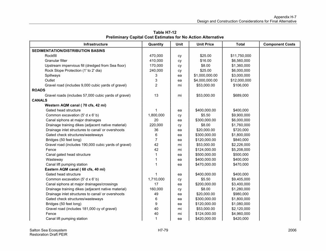
Appendix H-7 Design and Construction Considerations for Final Alternative
Salton Sea Ecosystem H7-79 2006 Restoration Draft PEIR
Table H7-12 Preliminary Capital Cost Estimates for No Action Alternative
Infrastructure Quantity Unit Unit Price Total Component Costs
SEDIMENTATION/DISTRIBUTION BASINS Rockfill 470,000 cy $25.00 $11,750,000 Granular filter 410,000 cy $16.00 $6,560,000 Upstream impervious fill (dredged from Sea floor) 170,000 cy $8.00 $1,360,000 Rock Slope Protection (1' to 2' dia) 240,000 cy $25.00 $6,000,000 Spillways 3 ea $1,000,000.00 $3,000,000 Outlet 3 ea $4,000,000.00 $12,000,000 Gravel road (includes 9,000 cubic yards of gravel) 2 mi $53,000.00 $106,000 ROADS Gravel roads (includes 57,000 cubic yards of gravel) 13 mi $53,000.00 $689,000 CANALS Western AQM canal ( 70 cfs, 42 mi) Gated head structure 1 ea $400,000.00 $400,000 Common excavation (5' d x 6' b) 1,800,000 cy $5.50 $9,900,000 Canal siphons at major drainages 20 ea $300,000.00 $6,000,000 Drainage training dikes (adjacent native material) 220,000 cy $8.00 $1,760,000 Drainage inlet structures to canal/ or overshoots 36 ea $20,000.00 $720,000 Gated check structures/wasteways 6 ea $300,000.00 $1,800,000 Bridges (50 feet long) 7 ea $120,000.00 $840,000 Gravel road (includes 190,000 cubic yards of gravel) 42 mi $53,000.00 $2,226,000 Fence 42 mi $124,000.00 $5,208,000 Canal gated head structure 1 ea $500,000.00 $500,000 Wasteway 1 ea $400,000.00 $400,000 Canal lift pumping station 1 ea $470,000.00 $470,000 Eastern AQM canal ( 60 cfs, 40 mi) Gated head structure 1 ea $400,000.00 $400,000 Common excavation (5' d x 6' b) 1,710,000 cy $5.50 $9,405,000 Canal siphons at major drainages/crossings 17 ea $200,000.00 $3,400,000 Drainage training dikes (adjacent native material) 160,000 cy $8.00 $1,280,000 Drainage inlet structures to canal/ or overshoots 49 ea $20,000.00 $980,000 Gated check structures/wasteways 6 ea $300,000.00 $1,800,000 Bridges (50 feet long) 9 ea $120,000.00 $1,080,000 Gravel road (includes 181,000 cy of gravel) 40 mi $53,000.00 $2,120,000 Fence 40 mi $124,000.00 $4,960,000 Canal lift pumping station 1 ea $420,000.00 $420,000

Appendix H-7 Design and Construction Considerations for Final Alternatives
2006 H7-80 Salton Sea Ecosystem Restoration Draft PEIR
Table H7-12 Preliminary Capital Cost Estimates for No Action Alternative
Infrastructure Quantity Unit Unit Price Total Component Costs Central AQM canal ( 40 cfs, 10 mi) Gated head structure 1 ea $300,000.00 $300,000 Common excavation (5' d x 6' b) 430,000 cy $5.50 $2,365,000 Bridges (50 feet long) 1 ea $120,000.00 $120,000 Gravel road (includes 45,000 cy of gravel) 10 mi $53,000.00 $530,000 Fence 10 mi $124,000.00 $1,240,000 Saltwater conveyance for AQM Canals/collection ponds (based on WEV area) 24,000 acres $300.00 $7,200,000 Pump station (20 cfs, 50 feet head, 170 hp) 5 ea $1,020,000.00 $5,100,000 Pump station (10 cfs, 10 feet head, 20 hp) 12 ea $120,000.00 $1,440,000 Pupfish Channels (30 mi) Common excavation (5' d x 6' b) 560,000 cy $5.50 $3,080,000 Bridges (50 feet long) 6 ea $120,000.00 $720,000 Gravel road (includes 78,000 cy of gravel) 30 mi $53,000.00 $1,590,000 Conveyance Fence 30 mi $124,000.00 $3,720,000 $124,939,000AIR QUALITY MANAGEMENT Water efficient vegetation Land preparation & facilities 24,000 acres $14,000.00 $336,000,000 Air Quality Man. Other AQM 9,000 acres $7,000.00 $63,000,000 $399,000,000 Subtotal $523,939,000 Unlisted Items 5% $26,196,950 Subtotal $550,135,950 Contingency 30% $165,040,785 Construction Cost $715,176,735 Eng/Legal/Admin 12% $85,821,208 TOTAL CAPITAL $800,997,943Note: ac = acres, AQM = Air Quality Management, cfs = cubic feet/second, cy = cubic yards, dia = diameter, ea = each, mi = miles, sf = square feet, and WEV = Water efficient vegetation

Appendix H-7 Design and Construction Considerations for Final Alternatives
Salton Sea Ecosystem H7-81 2006 Restoration Draft PEIR
Table H7-13 Preliminary Capital Cost Estimates for Alternative 1
Infrastructure Quantity Unit Unit Price Total Component Costs SEDIMENTATION/DISTRIBUTION BASINS Rockfill 470,000 cy $23.00 $10,810,000 Granular filter 410,000 cy $16.00 $6,560,000 Upstream impervious fill (dredged from Sea floor) 170,000 cy $8.00 $1,360,000 Rock Slope Protection (1' to 2' dia) 240,000 cy $23.00 $5,520,000 Spillways 3 ea $1,000,000.00 $3,000,000 Outlet 3 ea $4,000,000.00 $12,000,000 Gravel road (includes 9,000 cubic yards of gravel) 2 mi $53,000.00 $106,000 ROADS
Gravel roads (includes 53,000 cubic yards of gravel) 12 mi $53,000.00 $636,000 CANALS West AQM canal (110 cfs, 31 mi) Common excavation (6' d x 8' b to 5' d x6' b) 1,330,000 cy $5.50 $7,315,000 Canal siphons at major drainages 15 ea $400,000.00 $6,000,000 Drainage training dikes (adjacent native material) 164,000 cy $8.00 $1,312,000 Drainage inlet structures to canal/ or overshoots 25 ea $20,000.00 $500,000 Gated check structures/wasteways 5 ea $400,000.00 $2,000,000 Bridges (50 feet long) 7 ea $120,000.00 $840,000 Gravel road (includes 140,000 cy of gravel) 31 mi $53,000.00 $1,643,000 Fence 31 mi $124,000.00 $3,844,000 Wasteway 1 ea $400,000.00 $400,000 Canal lift pumping station (100 hp) 1 ea $700,000.00 $700,000 East AQM canal ( 110 cfs, 32 mi) Common excavation (6' d x 8' b to 5' d x6' b) 1,370,000 cy $5.50 $7,535,000 Canal siphons at major drainages/crossings 17 ea $400,000.00 $6,800,000 Drainage training dikes (adjacent native material) 170,000 cy $8.00 $1,360,000 Drainage inlet structures to canal/ or overshoots 30 ea $20,000.00 $600,000 Gated check structures/wasteways 5 ea $400,000.00 $2,000,000 Bridges (50 feet long) 7 ea $120,000.00 $840,000 Gravel road (includes 145,000 cubic yards of gravel) 32 mi $53,000.00 $1,696,000 Fence 32 mi $124,000.00 $3,968,000 Canal lift pumping station (100 hp) 1 ea $700,000.00 $700,000 1st SHC & AQM canals (3 @ 170 cfs, 25 mi total)

Appendix H-7 Design and Construction Considerations for Final Alternatives
2006 H7-82 Salton Sea Ecosystem Restoration Draft PEIR
Table H7-13 Preliminary Capital Cost Estimates for Alternative 1
Infrastructure Quantity Unit Unit Price Total Component Costs Gated head structure 4 ea $600,000.00 $2,400,000 Common excavation (6'd x 10' b) 770,000 cy $5.50 $4,235,000 Gated check structures/wasteways 2 ea $500,000.00 $1,000,000 Bridges (55 feet long) 3 ea $132,000.00 $396,000 Gravel road (includes 113,000 cy of gravel) 25 mi $53,000.00 $1,325,000 Canal lift pumping station (150 hp) 1 ea $1,000,000.00 $1,000,000 2nd SHC canals (3 @ 60 cfs, 23 mi total) Gated head structure 4 ea $400,000.00 $1,600,000 Common excavation (5' d x 6' b) 430,000 cy $5.50 $2,365,000 Gated check structures/wasteways 3 ea $300,000.00 $900,000 Bridges (50 feet long) 3 ea $120,000.00 $360,000 Gravel road (includes 60,000 cy of gravel) 23 mi $53,000.00 $1,219,000 3rd SHC canals (3 @ 60 cfs, 17 mi total) Gated head structure 4 ea $400,000.00 $1,600,000 Common excavation (5' d x 6' b) 320,000 cy $5.50 $1,760,000 Gated check structures/wasteways 2 ea $300,000.00 $600,000 Bridges (50 feet long) 2 ea $120,000.00 $240,000 Gravel road (includes 44,000 cy of gravel) 17 mi $53,000.00 $901,000 Saltwater conveyance for AQM Canals/collection ponds (based on WEV area) 41,000 acres $300.00 $12,300,000 Pump station (20 cfs, 50 feet head, 170 hp) 5 ea $1,020,000.00 $5,100,000 Pump station (10 cfs, 10 feet head, 20 hp) 20 ea $120,000.00 $2,400,000 Pupfish channels (28 mi) Common excavation (5' d x 6' b) 536,000 cy $5.50 $2,948,000 Bridges (50 feet long) 6 ea $120,000.00 $720,000 Gravel road (includes 73,000 cy of gravel) 28 mi $53,000.00 $1,484,000 Conveyance Fence 28 mi $124,000.00 $3,472,000 $140,370,000SALINE HABITAT COMPLEX Habitat berms embankment (homogenous/local) 19,420,000 cy $12.00 $233,040,000 Excavation for berms 9,030,000 cy $6.00 $54,180,000 Granular filter (gravel) 1,520,000 cy $18.00 $27,360,000 Rock Slope Protection (18-inch minus) 3,040,000 cy $21.00 $63,840,000 Contouring (deep excavation/islands/peninsulas) 43,430,000 cy $5.50 $238,865,000 20-foot gravel road 93 mi $53,000.00 $4,929,000 16-foot gravel road 62 mi $40,000.00 $2,480,000

Appendix H-7 Design and Construction Considerations for Final Alternatives
Salton Sea Ecosystem H7-83 2006 Restoration Draft PEIR
Table H7-13 Preliminary Capital Cost Estimates for Alternative 1
Infrastructure Quantity Unit Unit Price Total Component Costs 65-foot gated water control culvert 564 ea $20,000.00 $11,280,000 40-foot gated water control culvert 63 ea $5,500.00 $346,500 25-foot gated water control culvert 251 ea $4,000.00 $1,004,000 Portable truck mounted pumps (10 cfs, 20 feet head) 5 ea $200,000.00 $1,000,000 Other Constructed Gravel road (includes 403,000 cy of gravel) Habitat EARLY START HABITAT 2,000 acres $25,000.00 $50,000,000 $688,324,500AIR QUALITY MANAGEMENT Water efficient vegetation Construction for unit area 41,000 acres $14,000.00 $574,000,000 Air Quality Man. Other AQM 17,000 acres $7,000.00 $119,000,000 $693,000,000 Subtotal $1,521,694,500 Unlisted Items 5% $76,084,725 Subtotal $1,597,779,225 Contingency 30% $479,333,768 Construction Cost $2,077,112,993 Eng/Legal/Admin 12% $249,253,559 TOTAL CAPITAL $2,326,366,552Note: ac = acres, AQM = Air Quality Management, cfs = cubic feet/second, cy = cubic yards, dia = diameter, ea = each, mi = miles, sf = square feet, SHC = Saline Habitat Complex, and WEV = Water efficient vegetation

Appendix H-7 Design and Construction Considerations for Final Alternatives
2006 H7-84 Salton Sea Ecosystem Restoration Draft PEIR
Table H7-14
Preliminary Capital Cost Estimates for Alternative 2 Infrastructure Quantity Unit Unit Price Total Component Costs SEDIMENTATION/DISTRIBUTION BASINS Rockfill 470,000 cy $23.00 $10,810,000 Granular filter 410,000 cy $16.00 $6,560,000 Upstream impervious fill (dredged from Sea floor) 170,000 cy $8.00 $1,360,000 Rock Slope Protection (1' to 2' dia) 240,000 cy $23.00 $5,520,000 Spillways 3 ea $1,000,000.00 $3,000,000 Outlet 3 ea $4,000,000.00 $12,000,000 Gravel road (includes 9,000 cubic yards of gravel) 2 mi $53,000.00 $106,000 ROADS Gravel roads (includes 52,000 cubic yards of gravel) 12 mi $53,000.00 $636,000 CANALS West AQM canal (90 cfs, 38 mi) Gated head structure 1 ea $500,000.00 $500,000 Common excavation (6' d x 8' b to 5' d x6' b) 2,125,000 cy $5.50 $11,687,500 Canal siphons at major drainages 15 ea $400,000.00 $6,000,000 Drainage training dikes (adjacent native material) 200,000 cy $8.00 $1,600,000 Drainage inlet structures to canal/ or overshoots 30 ea $20,000.00 $600,000 Gated check structures/wasteways 5 ea $400,000.00 $2,000,000 Bridges (50 feet long) 7 ea $120,000.00 $840,000 Gravel road (includes 172,000 cy of gravel) 38 mi $53,000.00 $2,014,000 Fence 38 mi $124,000.00 $4,712,000 Canal gated head structure 1 ea $500,000.00 $500,000 Wasteway 1 ea $400,000.00 $400,000 Canal lift pumping station 1 ea $700,000.00 $700,000 East AQM canal ( 90 cfs, 35 mi) Gated head structure 1 ea $500,000.00 $500,000 Common excavation (6' d x 8' b to 5' d x6' b) 1,990,000 cy $5.50 $10,945,000 Canal siphons at major drainages/crossings 17 ea $400,000.00 $6,800,000 Drainage training dikes (adjacent native material) 185,000 cy $8.00 $1,480,000 Gated check structures/wasteways 5 ea $400,000.00 $2,000,000 Bridges (50 feet long) 7 ea $120,000.00 $840,000 Gravel road (includes 158,000 cy of gravel) 35 mi $53,000.00 $1,855,000 Fence 35 mi $124,000.00 $4,340,000 Canal lift pumping station 1 ea $700,000.00 $700,000

Appendix H-7 Design and Construction Considerations for Final Alternatives
Salton Sea Ecosystem H7-85 2006 Restoration Draft PEIR
Table H7-14 Preliminary Capital Cost Estimates for Alternative 2
Infrastructure Quantity Unit Unit Price Total Component Costs Saltwater conveyance for AQM Canals/collection ponds (based on WEV area) 46,000 acres $300.00 $13,800,000 Pump station (20 cfs, 50 feet head, 170 hp) 5 ea $1,020,000.00 $5,100,000 Pump station (10 cfs, 10 feet head, 20 hp) 23 ea $120,000.00 $2,760,000 Saltwater conveyance for Habitat Canals/pipes 42 mi $400,000.00 $16,800,000 Saltwater pumping stations (30 cfs, 50 feet head) 4 ea $1,050,000.00 $4,200,000 Conveyance Saltwater pumping stations (10 cfs, 10 feet head) 20 ea $110,000.00 $2,200,000 $145,865,500 SALINE HABITAT COMPLEX Habitat berms embankment (homogenous/local) 39,420,000 cy $12.00 $473,040,000 Excavation for berms 18,160,000 cy $6.00 $108,960,000 Granular filter (gravel) 3,120,000 cy $18.00 $56,160,000 Rock Slope Protection (18-inch minus) 6,230,000 cy $21.00 $130,830,000 Contouring (deep excavation/islands/peninsulas) 74,280,000 cy $5.50 $408,540,000 20-foot gravel road 207 mi $53,000.00 $10,971,000 16-foot gravel road 104 mi $40,000.00 $4,160,000 65-foot gated water control culvert 978 ea $20,000.00 $19,560,000 40-foot gated water control culvert 109 ea $5,500.00 $599,500 25-foot gated water control culvert 435 ea $4,000.00 $1,740,000 Other Constructed Gravel road (includes 809,000 cubic yards of gravel) Habitat EARLY START HABITAT 2,000 acres $25,000.00 $50,000,000 $1,264,560,500 AIR QUALITY MANAGEMENT Water efficient vegetation Land preparation & facilities 46,000 acres $14,000.00 $644,000,000 Air Quality Man. Other AQM 18,000 acres $7,000.00 $126,000,000 $770,000,000 Subtotal $2,180,426,000 Unlisted Items 5% $109,021,300 Subtotal $2,289,447,300 Contingency 30% $686,834,190 Construction Cost $2,976,281,490 Eng/Legal/Admin 12% $357,153,779 TOTAL CAPITAL $3,333,435,269 Note: ac = acres, AQM = Air Quality Management, cfs = cubic feet/second, cy = cubic yards, dia = diameter, ea = each, mi = miles, sf = square feet, SHC = Saline Habitat Complex, and WEV = Water efficient vegetation

Appendix H-7 Design and Construction Considerations for Final Alternatives
2006 H7-86 Salton Sea Ecosystem Restoration Draft PEIR
Table H7-15 Preliminary Capital Cost Estimates for Alternative 3
Infrastructure Quantity Unit Unit Price Total Component Costs SECOND RING DIKE Embankment Rockfill (1' to 3' dia) 26,460,000 cy $23.00 $608,580,000 Granular filter 9,550,000 cy $14.00 $133,700,000 Upstream impervious fill (dredged from Sea floor) 7,160,000 cy $6.00 $42,960,000 Rock Slope Protection (1' to 2' dia) 7,160,000 cy $23.00 $164,680,000 Spillway (300' long structure) Cofferdam cells 45,000 sf $19.00 $855,000 Reinforced concrete labyrinth spillway structure 3 ea $2,000,000.00 $6,000,000 Outlet (200 cfs capacity) Reinforced concrete outlet structure 2 ea $600,000.00 $1,200,000 Bridges to Dike 2 ea $500,000.00 $1,000,000 FIRST RING DIKE Embankment Rockfill (1' to 3' dia) 24,500,000 cy $25.00 $612,500,000 Granular filter 8,850,000 cy $16.00 $141,600,000 Upstream impervious fill (dredged from Sea floor) 6,640,000 cy $8.00 $53,120,000 Rock Slope Protection (1' to 2' dia) 6,640,000 cy $25.00 $166,000,000 Spillway (300' long structure) Cofferdam cells 45,000 cy $12.00 $540,000 Reinforced concrete labyrinth spillway structure 3 ea $200,000.00 $600,000 Outlet (200 cfs capacity) Reinforced concrete outlet structure 2 ea $600,000.00 $1,200,000 Barriers/Dikes Bridges to Dike 2 ea $500,000.00 $1,000,000 $1,935,535,000 SEDIMENTATION/DISTRIBUTION BASINS Rockfill 310,000 cy $23.00 $7,130,000 Granular filter 270,000 cy $16.00 $4,320,000 Upstream impervious fill (dredged from Sea floor) 110,000 cy $8.00 $880,000 Rock Slope Protection (1' to 2' dia) 160,000 cy $23.00 $3,680,000 Spillways 2 ea $1,000,000.00 $2,000,000 Outlet 2 ea $4,000,000.00 $8,000,000 Gravel road (includes 5,000 cubic yards of gravel) 1 mi $53,000.00 $53,000 Alamo River box culverts (4 precast @ 8' x 8') 10,600 ft $1,650.00 $17,490,000

Appendix H-7 Design and Construction Considerations for Final Alternatives
Salton Sea Ecosystem H7-87 2006 Restoration Draft PEIR
Table H7-15 Preliminary Capital Cost Estimates for Alternative 3
Infrastructure Quantity Unit Unit Price Total Component Costs New River box culverts (3 precast @ 8' x 8') 25,000 ft $1,250.00 $31,250,000 River outlet structures 4 ea $2,000,000.00 $8,000,000 ROADS Gravel roads (includes 893,000 cubic yards of gravel) 198 mi $53,000.00 $10,494,000 CANALS Inner AQM canals (2 @ 210 cfs, total 78 mi) Gated head structure 4 ea $400,000.00 $1,600,000 Common excavation (8' d x 10' b to 12'd x 14'b)) 4,855,000 cy $5.50 $26,702,500 Bridges (50 feet long) 12 ea $120,000.00 $1,440,000 Gravel road (includes 352,000 cubic yards of gravel) 78 mi $53,000.00 $4,134,000 Fence 78 mi $124,000.00 $9,672,000 Canal gated head structure 1 ea $500,000.00 $500,000 Wasteway 1 ea $400,000.00 $400,000 Canal lift pumping station 2 ea $1,100,000.00 $2,200,000 Saltwater conveyance for AQM Canals/collection ponds (based on WEV area) 63,000 acres $300.00 $18,900,000 Pump station (20 cfs, 50 feet head, 170 hp) 6 ea $1,020,000.00 $6,120,000 Pump station (10 cfs, 10 feet head, 20 hp) 32 ea $120,000.00 $3,840,000 Recirculation Pumps Outer ring pumping station 1 ea $1,500,000.00 $1,500,000 Conveyance Inner ring pumping station 1 ea $1,500,000.00 $1,500,000 $171,805,500 EARLY START HABITAT 2,000 acres $25,000.00 $50,000,000 Other Const. Habitat $50,000,000 AIR QUALITY MANAGEMENT Water efficient vegetation Land preparation & facilities 63,000 acres $14,000.00 $882,000,000 Air Quality Man. Other AQM 26,000 acres $7,000.00 $182,000,000 $1,064,000,000 Subtotal $3,221,340,500 Unlisted Items 5% $161,067,025 Subtotal $3,382,407,525 Contingency 30% $1,014,722,258 Construction Cost $4,397,129,783 Eng/Legal/Admin 12% $527,655,574 TOTAL CAPITAL $4,924,785,356 Note: ac = acres, AQM = Air Quality Management, cfs = cubic feet/second, cy = cubic yards, dia = diameter, ea = each, mi = miles, sf = square feet, SHC = Saline Habitat Complex, and WEV = Water efficient vegetation

Appendix H-7 Design and Construction Considerations for Final Alternatives
2006 H7-88 Salton Sea Ecosystem Restoration Draft PEIR
Table H7-16 Preliminary Capital Cost Estimates for Alternative 4
Infrastructure Quantity Unit Unit Price Total Component Costs GEOTUBE® BERMS Embankment Geotextile on Foundation 28,240,000 sy $2.00 $56,480,000 Tubes 11,280,000 sf $2.50 $28,200,000 Fill Geotubes® (dredged from Sea floor) 16,535,000 cy $14.00 $231,490,000 General Dredge Fill 32,900,000 cy $8.00 $263,200,000 Granular Filter 3,000,000 cy $16.00 $48,000,000 Rock Slope Protection (1' to 2' dia) 3,000,000 cy $23.00 $69,000,000 Spillways Cofferdam cells 132,000 sf $19.00 $2,508,000 Adjustable spillway structure 22 ea $1,000,000.00 $22,000,000 Outlet (200 cfs capacity) Dredging of channels 100,000 cy $6.00 $600,000 Reinforced concrete outlet structure 8 ea $600,000.00 $4,800,000 Barriers/Dikes Bridges to Dike 8 ea $500,000.00 $4,000,000 $730,278,000 SEDIMENTATION/DISTRIBUTION BASINS Rockfill 310,000 cy $23.00 $7,130,000 Granular filter 180,000 cy $16.00 $2,880,000 Upstream impervious fill (dredged from Sea floor) 110,000 cy $8.00 $880,000 Rock Slope Protection (1' to 2' dia) 280,000 cy $23.00 $6,440,000 Spillways 2 ea $1,000,000.00 $2,000,000 Outlet 2 ea $4,000,000.00 $8,000,000 Gravel road (includes 5,000 cubic yards of gravel) 1 mi $53,000.00 $53,000 Alamo River box culverts (4 precast @ 8' x 8') 25,000 ft $1,650.00 $41,250,000 New River box culverts (3 precast @ 8' x 8') 39,000 ft $1,250.00 $48,750,000 River outlet structures 8 ea $2,000,000.00 $16,000,000 CANALS Irrigation canals (<30 cfs, 251 mi) Gated head structure 4 ea $200,000.00 $800,000 Common excavation (5' d x 6' b) 4,670,000 cy $5.50 $25,685,000 Bridges (50 feet long) 50 ea $120,000.00 $6,000,000 Gravel road (includes 645,000 cubic yards of gravel) 251 mi $53,000.00 $13,303,000 Canal gated head structure 4 ea $500,000.00 $2,000,000

Appendix H-7 Design and Construction Considerations for Final Alternatives
Salton Sea Ecosystem H7-89 2006 Restoration Draft PEIR
Table H7-16 Preliminary Capital Cost Estimates for Alternative 4
Infrastructure Quantity Unit Unit Price Total Component Costs Wasteway 4 ea $400,000.00 $1,600,000 Conveyance Canal lift pumping station 8 ea $180,000.00 $1,440,000 $184,211,000 SALINE HABITAT COMPLEX Contouring (deep excavation/islands/peninsulas) 100,000,000 cy $5.50 $550,000,000 Other Constructed Habitat EARLY START HABITAT 2,000 acres $25,000.00 $50,000,000 $600,000,000 Subtotal $1,514,489,000 Unlisted Items 5% $75,724,450 Subtotal $1,590,213,450 Contingency 30% $477,064,035 Construction Cost $2,067,277,485 Eng/Legal/Admin 12% $248,073,298
TOTAL CAPITAL
COST $2,315,350,783 Note: ac = acres, AQM = Air Quality Management, cfs = cubic feet/second, cy = cubic yards, dia = diameter, ea = each, mi = miles, sf = square feet, SHC = Saline Habitat Complex, and WEV = Water efficient vegetation

Appendix H-7 Design and Construction Considerations for Final Alternatives
2006 H7-90 Salton Sea Ecosystem Restoration Draft PEIR
Table H7-17 Preliminary Capital Cost Estimates for Alternative 5
Infrastructure Quantity Unit Unit Price Total Component Costs BARRIER Embankment Rockfill (1' to 4' dia) 36,400,000 cy $23.00 $837,200,000 Granular filter 6,240,000 cy $14.00 $87,360,000 Upstream impervious fill (dredged from Sea floor) 3,900,000 cy $6.00 $23,400,000 Rock Slope Protection (1' to 3' dia) 3,900,000 cy $23.00 $89,700,000 Spillway (1000' long structure) Cofferdam cells 44,000 sf $19.00 $836,000 Reinforced concrete labyrinth spillway structure 1 ea $4,000,000.00 $4,000,000 Outlet (200 cfs capacity) Dredging of inlet and outlet channels 44,000 cy $6.00 $264,000 Reinforced concrete outlet structure 1 ea $600,000.00 $600,000 Barriers/Dikes Bridges to barrier 2 ea $1,000,000.00 $2,000,000 $1,045,360,000 SEDIMENTATION/DISTRIBUTION BASINS Rockfill 310,000 cy $23.00 $7,130,000 Granular filter 270,000 cy $16.00 $4,320,000 Upstream impervious fill (dredged from Sea floor) 110,000 cy $8.00 $880,000 Rock Slope Protection (1' to 2' dia) 160,000 cy $23.00 $3,680,000 Spillways 2 ea $1,000,000.00 $2,000,000 Outlet 2 ea $4,000,000.00 $8,000,000 Gravel road (includes 5,000 cubic yards of gravel) 1 mi $53,000.00 $53,000 ROADS Gravel roads (includes 415,000 cubic yards of gravel) 92 mi $53,000.00 $4,870,137 CANALS Alamo River to New River canal (800 cfs, 10 mi) Gated head structure 1 ea $4,000,000.00 $4,000,000 Common excavation (10' d x 24' b) 1,030,000 cy $5.50 $5,665,000 Drainage inlet structures to canal/ or overshoots 10 ea $20,000.00 $200,000 Bridges (85 feet long) 2 ea $204,000.00 $408,000 Gravel road (includes 45,000 cy of gravel) 10 mi $53,000.00 $530,000 Fence 10 mi $124,000.00 $1,240,000 Canal gated head structure 1 ea $1,500,000.00 $1,500,000 Wasteway 1 ea $800,000.00 $800,000

Appendix H-7 Design and Construction Considerations for Final Alternatives
Salton Sea Ecosystem H7-91 2006 Restoration Draft PEIR
Table H7-17 Preliminary Capital Cost Estimates for Alternative 5
Infrastructure Quantity Unit Unit Price Total Component Costs Canal lift pumping station 1 ea $2,800,000.00 $2,800,000 North Sea/AQM canal ( 1200 cfs, 27 mi) Gated head structure 1 ea $5,000,000.00 $5,000,000 Common excavation (14' d x 24' b) 4,610,000 cy $5.50 $25,355,000 Canal siphons at major drainages/crossings 15 ea $1,000,000.00 $15,000,000 Drainage training dikes (adjacent native material) 200,000 cy $8.00 $1,600,000 Drainage inlet structures to canal/ or overshoots 30 ea $20,000.00 $600,000 Gated check structures/wasteways 1 ea $1,000,000.00 $1,000,000 Bridges (100 feet long) 6 ea $240,000.00 $1,440,000 Gravel road (includes 122,000 cy of gravel) 27 mi $53,000.00 $1,431,000 Fence 27 mi $124,000.00 $3,348,000 Canal lift pumping station 1 ea $3,740,000.00 $3,740,000 East AQM canal (200 cfs, 25 mi) Gated head structure 1 ea $500,000.00 $500,000 Common excavation (6' d x 12' b) 1,070,000 cy $5.50 $5,885,000 Canal siphons at major drainages 3 ea $1,000,000.00 $3,000,000 Drainage training dikes (adjacent native material) 200,000 cy $8.00 $1,600,000 Drainage inlet structures to canal/ or overshoots 30 ea $20,000.00 $600,000 Gated check structures/wasteways 5 ea $500,000.00 $2,500,000 Bridges (95 feet long) 6 ea $228,000.00 $1,368,000 Gravel road (includes 113,000 cy of gravel) 27 mi $53,000.00 $1,431,000 Fence 27 mi $124,000.00 $3,348,000 Canal gated head structure 1 ea $1,500,000.00 $1,500,000 Wasteway 1 ea $800,000.00 $800,000 Canal lift pumping station 1 ea $1,100,000.00 $1,100,000 Marine Sea Outlet canal ( 200 cfs, 10 mi) Gated head structure 1 ea $1,000,000.00 $1,000,000 Common excavation (6' d x 12' b) 506,000 cy $5.50 $2,783,000 Canal siphons at major drainages/crossings 3 ea $500,000.00 $1,500,000 Gated check structures/wasteways 2 ea $500,000.00 $1,000,000 Bridges (60 feet long) 1 ea $144,000.00 $144,000 Gravel road (includes 45,000 cy of gravel) 10 mi $53,000.00 $530,000 Fence 10 mi $124,000.00 $1,240,000 Saltwater conveyance for AQM Canals/collection ponds (based on WEV area) 59,000 acres $300.00 $17,700,000

Appendix H-7 Design and Construction Considerations for Final Alternatives
2006 H7-92 Salton Sea Ecosystem Restoration Draft PEIR
Table H7-17 Preliminary Capital Cost Estimates for Alternative 5
Infrastructure Quantity Unit Unit Price Total Component Costs Pump station (20 cfs, 50 feet head, 170 hp) 6 ea $1,020,000.00 $6,120,000 Pump station (10 cfs, 10 feet head, 20 hp) 30 ea $120,000.00 $3,600,000 Saltwater conveyance for Habitat Canals/pipes 34 mi $400,000.00 $13,600,000 Saltwater pumping stations (30 cfs, 50 feet head) 2 ea $1,050,000.00 $2,100,000 Conveyance Saltwater pumping stations (10 cfs, 10 feet head) 8 ea $110,000.00 $880,000 $182,419,137 SALINE HABITAT COMPLEX Habitat berms embankment (homogenous/local) 21,710,000 cy $12.00 $260,520,000 Excavation for berms 9,960,000 cy $6.00 $59,760,000 Granular filter (gravel) 1,750,000 cy $18.00 $31,500,000 Rock Slope Protection (18-inch minus) 3,500,000 cy $21.00 $73,500,000 Contouring (deep excavation/islands/peninsulas) 43,430,000 cy $5.50 $238,865,000 20-foot gravel road 113 mi $53,000.00 $5,989,000 16-foot gravel road 62 mi $40,000.00 $2,480,000 65-foot gated water control culvert 474 ea $20,000.00 $9,480,000 40-foot gated water control culvert 53 ea $5,500.00 $291,500 25-foot gated water control culvert 211 ea $4,000.00 $844,000
Gravel road (includes 455,000 cubic yards of gravel) Other Constructed Habitat
EARLY START HABITAT 2,000 acres $25,000.00 $50,000,000 $733,229,500 AIR QUALITY MANAGEMENT Water efficient vegetation Land preparation & facilities 59,000 acres $14,000.00 $826,000,000 Air Quality Man. Other AQM 24,000 acres $7,000.00 $168,000,000 $994,000,000 Subtotal $2,955,008,637 Unlisted Items 5% $147,750,432 Subtotal $3,102,759,069 Contingency 30% $930,827,721 Construction Cost $4,033,586,790 Eng/Legal/Admin 12% $484,030,415 TOTAL CAPITAL $4,517,617,204 Note: ac = acres, AQM = Air Quality Management, cfs = cubic feet/second, cy = cubic yards, dia = diameter, ea = each, mi = miles, sf = square feet, SHC = Saline Habitat Complex, and WEV = Water efficient vegetation

Appendix H-7 Design and Construction Considerations for Final Alternatives
Salton Sea Ecosystem H7-93 2006 Restoration Draft PEIR
Table H7-18 Preliminary Capital Cost Estimates for Alternative 6
Infrastructure Quantity Unit Unit Price Total Component Costs BARRIER Embankment Rockfill (1' to 4' dia) 41,200,000 cy $23.00 $947,600,000 Granular filter 7,000,000 cy $14.00 $98,000,000 Upstream impervious fill (dredged from Sea floor) 4,250,000 cy $6.00 $25,500,000 Rock Slope Protection (1' to 3' dia) 4,250,000 cy $23.00 $97,750,000 Spillway (1000' long structure) Cofferdam cells 44,000 sf $19.00 $836,000 Reinforced concrete labyrinth spillway structure 1 ea $4,000,000.00 $4,000,000 Outlet (200 cfs capacity) Dredging of inlet and outlet channels 44,000 cy $6.00 $264,000 Reinforced concrete outlet structure 1 ea $600,000.00 $600,000 Bridges to barrier 2 ea $1,000,000.00 $2,000,000 PERIMETER DIKES Embankment Rockfill (1' to 3' dia) 25,960,000 cy $25.00 $649,000,000 Granular filter 5,700,000 cy $16.00 $91,200,000 Upstream impervious fill (dredged from Sea floor) 4,110,000 cy $8.00 $32,880,000 Barriers/Dikes Rock Slope Protection (1' to 2' dia) 4,110,000 cy $25.00 $102,750,000 $2,052,380,000 SEDIMENTATION/DISTRIBUTION BASINS Rockfill 160,000 cy $23.00 $3,680,000 Granular filter 80,000 cy $16.00 $1,280,000 Upstream impervious fill (dredged from Sea floor) 60,000 cy $8.00 $480,000 Rock Slope Protection (1' to 2' dia) 80,000 cy $23.00 $1,840,000 Spillways 1 ea $1,000,000.00 $1,000,000 Outlet 1 ea $4,000,000.00 $4,000,000 Gravel road (includes 5,000 cubic yards of gravel) 1 mi $53,000.00 $53,000 ROADS Gravel roads (includes 630,000 cubic yards of gravel) 139 mi $53,000.00 $7,367,000 CANALS Inner AQM canal (250 cfs, 28 mi) Gated head structure 1 ea $600,000.00 $600,000 Common excavation (6' d x 10' b to 7' d x 14' b) 1,674,000 cy $5.50 $9,207,000

Appendix H-7 Design and Construction Considerations for Final Alternatives
2006 H7-94 Salton Sea Ecosystem Restoration Draft PEIR
Table H7-18 Preliminary Capital Cost Estimates for Alternative 6
Infrastructure Quantity Unit Unit Price Total Component Costs Canal siphons at major drainages 15 ea $400,000.00 $6,000,000 Drainage inlet structures to canal/ or overshoots 20 ea $20,000.00 $400,000 Gated check structures/wasteways 4 ea $400,000.00 $1,600,000 Bridges (60 feet long) 6 ea $144,000.00 $864,000 Gravel road (includes 126,000 cy of gravel) 28 mi $53,000.00 $1,484,000 Fence 28 mi $124,000.00 $3,472,000 Canal gated head structure 1 ea $500,000.00 $500,000 Wasteway 1 ea $400,000.00 $400,000 Canal lift pumping station 1 ea $1,320,000.00 $1,320,000 Eastern AQM canal (200 cfs, 27 mi) Gated head structure 1 ea $600,000.00 $600,000 Common excavation (6' d x 10' b to 7' d x 14' b) 1,534,000 cy $5.50 $8,437,000 Canal siphons at major drainages/crossings 3 ea $400,000.00 $1,200,000 Drainage training dikes (adjacent native material) 0 cy $8.00 $0 Drainage inlet structures to canal/ or overshoots 0 ea $20,000.00 $0 Gated check structures/wasteways 4 ea $400,000.00 $1,600,000 Bridges (55 feet long) 6 ea $132,000.00 $792,000 Gravel road (includes 122,000 cubic yards of gravel) 27 mi $53,000.00 $1,431,000 Fence 27 mi $124,000.00 $3,348,000 Canal lift pumping station 1 ea $1,060,000.00 $1,060,000 Marine Sea recirculation canal (1000 cfs, 28 mi) Gated head structure 1 ea $5,000,000.00 $5,000,000 Common excavation (12' d x 24' b) 3,800,000 cy $5.50 $20,900,000 Canal siphons at major drainages/crossings 3 ea $1,000,000.00 $3,000,000 Drainage training dikes (adjacent native material) 158,000 cy $8.00 $1,264,000 Drainage inlet structures to canal/ or overshoots 37 ea $20,000.00 $740,000 Gated check structures/wasteways 3 ea $1,000,000.00 $3,000,000 Bridges (95 feet long) 4 ea $228,000.00 $912,000 Gravel road (includes 126,000 cy of gravel) 28 mi $53,000.00 $1,484,000 Pumping station 1 ea $3,500,000.00 $3,500,000 Saltwater conveyance for AQM Canals/collection ponds (based on WEV area) 66,000 acres $300.00 $19,800,000 Pump station (20 cfs, 50 feet head, 170 hp) 6 ea $1,020,000.00 $6,120,000 Pump station (10 cfs, 10 feet head, 20 hp) 33 ea $120,000.00 $3,960,000 Saltwater conveyance for Habitat

Appendix H-7 Design and Construction Considerations for Final Alternatives
Salton Sea Ecosystem H7-95 2006 Restoration Draft PEIR
Table H7-18 Preliminary Capital Cost Estimates for Alternative 6
Infrastructure Quantity Unit Unit Price Total Component Costs Canals/pipes 25 mi $400,000.00 $10,000,000 Saltwater pumping stations (30 cfs, 50 feet head) 1 ea $1,700,000.00 $1,700,000 Saltwater pumping stations (10 cfs, 10 feet head) 5 ea $110,000.00 $550,000 Pupfish Channels (10 mi) Common excavation (5' d x 6' b) 430,000 cy $5.50 $2,365,000 Bridges (50 feet long) 2 ea $120,000.00 $240,000 Gravel road (includes 26,000 cy of gravel) 10 mi $53,000.00 $530,000 Conveyance Fence 10 mi $124,000.00 $1,240,000 $150,320,000 SALINE HABITAT COMPLEX Habitat berms embankment (homogenous/local) 15,970,000 cy $12.00 $191,640,000 Excavation for berms 7,380,000 cy $6.00 $44,280,000 Granular filter (gravel) 1,250,000 cy $18.00 $22,500,000 Rock Slope Protection (18-inch minus) 2,500,000 cy $21.00 $52,500,000 Contouring (deep excavation/islands/peninsulas) 27,560,000 cy $5.50 $151,580,000 20-foot gravel road 84 mi $53,000.00 $4,452,000 16-foot gravel road 41 mi $40,000.00 $1,640,000 65-foot gated water control culvert 420 ea $20,000.00 $8,400,000 40-foot gated water control culvert 47 ea $5,500.00 $258,500 25-foot gated water control culvert 187 ea $4,000.00 $748,000 Other Constructed Gravel road (includes 346,000 cubic yards of gravel) Habitat EARLY START HABITAT 2,000 acres $25,000.00 $50,000,000 $527,998,500 AIR QUALITY MANAGEMENT Water efficient vegetation Land preparation & facilities 66,000 acres $14,000.00 $924,000,000 Air Quality Man. Other AQM 26,000 acres $7,000.00 $182,000,000 $1,106,000,000 Subtotal $3,836,698,500 Unlisted Items 5% $191,834,925 Subtotal $4,028,533,425 Contingency 30% $1,208,560,028 Construction Cost $5,237,093,453 Eng/Legal/Admin 12% $628,451,214 TOTAL CAPITAL $5,865,544,667 Note:ac = acres, AQM = Air Quality Management, cfs = cubic feet/second, cy = cubic yards, dia = diameter, ea = each, mi = miles, sf = square feet, SHC = Saline Habitat Complex, and WEV = Water efficient vegetation

Appendix H-7 Design and Construction Considerations for Final Alternatives
2006 H7-96 Salton Sea Ecosystem Restoration Draft PEIR
Table H7-19 Preliminary Capital Cost Estimates for Alternative 7
Infrastructure Quantity Unit Unit Price Total Component Costs BARRIER Embankment Rockfill (1' to 4' dia) 28,300,000 cy $23.00 $650,900,000 Granular filter 2,970,000 cy $14.00 $41,580,000 Slurry Wall 3,800,000 sf $60.00 $228,000,000 Spillway (1000' long structure) Cofferdam cells 44,000 sf $19.00 $836,000 Reinforced concrete labyrinth spillway structure 1 ea $4,000,000.00 $4,000,000 Outlet (200 cfs capacity) Dredging of inlet and outlet channels 44,000 cy $6.00 $264,000 Reinforced concrete outlet structure 1 ea $600,000.00 $600,000 Bridges to barrier 2 ea $1,000,000.00 $2,000,000 PERIMETER DIKES Embankment Rockfill (1' to 3' dia) 15,200,000 cy $25.00 $380,000,000 Granular filter 11,900,000 cy $16.00 $190,400,000 Vinyl Sheet Pile 8,350,000 sf $24.00 $200,400,000 FRESHWATER RESERVOIR Embankment Rockfill (1' to 3' dia) 10,700,000 cy $25.00 $267,500,000 Granular filter 8,300,000 cy $16.00 $132,800,000 Vinyl Sheet Pile 3,150,000 sf $24.00 $75,600,000 Water Control Structures Reservoir Inlet 1 ls $20,000,000.00 $20,000,000 Barriers/Dikes Reservoir Outlet/Pumps 1 ls $5,000,000.00 $5,000,000 $2,199,880,000 SEDIMENTATION/DISTRIBUTION BASINS Rockfill 160,000 cy $23.00 $3,680,000 Granular filter 80,000 cy $16.00 $1,280,000 Upstream impervious fill (dredged from Sea floor) 60,000 cy $8.00 $480,000 Rock Slope Protection (1' to 2' dia) 80,000 cy $23.00 $1,840,000 Spillways 1 ea $1,000,000.00 $1,000,000 Outlet 1 ea $4,000,000.00 $4,000,000 Gravel road (includes 5,000 cubic yards of gravel) 1 mi $53,000.00 $53,000

Appendix H-7 Design and Construction Considerations for Final Alternatives
Salton Sea Ecosystem H7-97 2006 Restoration Draft PEIR
Table H7-19 Preliminary Capital Cost Estimates for Alternative 7
Infrastructure Quantity Unit Unit Price Total Component Costs CANALS Marine Sea Recirculation canal ( 1000 cfs, 20 mi) Gated head structure 1 ea $5,000,000.00 $5,000,000 Common excavation (12' d x 24' b) 2,700,000 cy $5.50 $14,850,000 Canal siphons at major drainages 3 ea $1,000,000.00 $3,000,000 Drainage training dikes (adjacent native material) 106,000 cy $8.00 $848,000 Drainage inlet structures to canal/ or overshoots 36 ea $20,000.00 $720,000 Gated check structures/wasteways 4 ea $1,000,000.00 $4,000,000 Bridges (95 feet long) 4 ea $228,000.00 $912,000 Gravel road (includes 90,000 cubic yards of gravel) 20 mi $53,000.00 $1,060,000 Fence 20 mi $124,000.00 $2,480,000 Canal gated head structure 1 ea $1,500,000.00 $1,500,000 Wasteway 1 ea $800,000.00 $800,000 Conveyance Pumping station 1 ea $3,500,000.00 $3,500,000 $51,003,000 WATER TREATMENT PLANT Sea outlet box culverts (4 precast @ 8' x 8') 45,500 ft $1,650.00 $75,075,000 Outlet structure 1 ea $5,000,000.00 $5,000,000
Treatment plant for recirculation (420,000 acre-feet/year per Salton Sea Authority) 1 ea $125,000,000.00 $125,000,000 Water Treatment
Treatment plant for Sea river inflow (325,000 acre-feet/year per Salton Sea Authority) 1 ea $125,000,000.00 $125,000,000 $330,075,000
SALINE HABITAT COMPLEX Habitat berms embankment (homogenous/local) 8,290,000 cy $12.00 $99,480,000 Excavation for berms 3,930,000 cy $6.00 $23,580,000 Granular filter (gravel) 600,000 cy $18.00 $10,800,000 Rock Slope Protection (18-inch minus) 1,190,000 cy $21.00 $24,990,000 Contouring (deep excavation/islands/peninsulas) 18,392,000 cy $5.50 $101,156,000 20-foot gravel road 39 mi $53,000.00 $2,067,000 16-foot gravel road 20 mi $40,000.00 $800,000 65-foot gated water control culvert 240 ea $20,000.00 $4,800,000 40-foot gated water control culvert 40 ea $5,500.00 $220,000 25-foot gated water control culvert 160 ea $4,000.00 $640,000 Gravel road (includes 153,000 cubic yards of gravel) UPSTREAM WETLANDS Other Constructed New & Alamo Rivers Wetlands 4,273 acres $26,700.00 $114,089,100 Habitat EARLY START WETLANDS 2,000 acres $25,000.00 $50,000,000 $432,622,100

Appendix H-7 Design and Construction Considerations for Final Alternatives
2006 H7-98 Salton Sea Ecosystem Restoration Draft PEIR
Table H7-19 Preliminary Capital Cost Estimates for Alternative 7
Infrastructure Quantity Unit Unit Price Total Component Costs AIR QUALITY MANAGEMENT Air Quality Man Salt crust facilities 66,500 acres $5,500.00 $365,750,000 $365,750,000 Subtotal $3,379,330,100 Unlisted Items 5% $168,966,505 Subtotal $3,548,296,605 Contingency 30% $1,064,488,982 Construction Cost $4,612,785,587 Eng/Legal/Admin 12% $553,534,270 TOTAL CAPITAL $5,166,319,857 Note: ac = acres, AQM = Air Quality Management, cfs = cubic feet/second, cy = cubic yards, dia = diameter, ea = each, mi = miles, sf = square feet, SHC = Saline Habitat Complex, and WEV = Water efficient vegetation

Appendix H-7 Design and Construction Considerations for Final Alternatives
Salton Sea Ecosystem H7-99 2006 Restoration Draft PEIR
Table H7-20 Preliminary Capital Cost Estimates for Alternative 8
Infrastructure Quantity Unit Unit Price Total Component Costs BARRIER Embankment Rockfill (1' to 4' dia) 42,920,000 cy $23.00 $987,160,000 Granular filter 8,120,000 cy $14.00 $113,680,000 Upstream impervious fill (dredged from Sea floor) 5,080,000 cy $6.00 $30,480,000 Rock Slope Protection (1' to 3' dia) 5,080,000 cy $23.00 $116,840,000 Spillway (1000' long structure) Cofferdam cells 44,000 sf $19.00 $836,000 Reinforced concrete labyrinth spillway structure 1 ea $4,000,000.00 $4,000,000 Outlet (200 cfs capacity) Dredging of inlet and outlet channels 44,000 cy $6.00 $264,000 Reinforced concrete outlet structure 1 ea $600,000.00 $600,000 Bridges to barrier 2 ea $1,000,000.00 $2,000,000 PERIMETER DIKES Embankment Rockfill (1' to 3' dia) 28,720,000 cy $25.00 $718,000,000 Granular filter 6,450,000 cy $16.00 $103,200,000 Upstream impervious fill (dredged from Sea floor) 4,760,000 cy $8.00 $38,080,000 Barriers/Dikes Rock Slope Protection (1' to 2' dia) 4,760,000 cy $25.00 $119,000,000 $2,234,140,000 SEDIMENTATION/DISTRIBUTION BASINS Rockfill 310,000 cy $25.00 $7,750,000 Granular filter 160,000 cy $16.00 $2,560,000 Upstream impervious fill (dredged from Sea floor) 110,000 cy $8.00 $880,000 Rock Slope Protection (1' to 2' dia) 160,000 cy $25.00 $4,000,000 Spillways 2 ea $1,000,000.00 $2,000,000 Outlet 2 ea $4,000,000.00 $8,000,000 Gravel road (includes 5,000 cubic yards of gravel) 1 mi $53,000.00 $53,000 ROADS Gravel roads (includes 642,000 cubic yards of gravel) 142 mi $53,000.00 $7,526,000 CANALS Western AQM canal (260 cfs, 46 mi) Gated head structure 1 ea $800,000.00 $800,000 Common excavation (8'd x 12' b to 12' d x 24' b) 2,708,000 cy $5.50 $14,894,000

Appendix H-7 Design and Construction Considerations for Final Alternatives
2006 H7-100 Salton Sea Ecosystem Restoration Draft PEIR
Table H7-20 Preliminary Capital Cost Estimates for Alternative 8
Infrastructure Quantity Unit Unit Price Total Component Costs Canal siphons at major drainages 20 ea $400,000.00 $8,000,000 Drainage training dikes (adjacent native material) 68,000 cy $8.00 $544,000 Drainage inlet structures to canal/ or overshoots 36 ea $20,000.00 $720,000 Gated check structures/wasteways 5 ea $400,000.00 $2,000,000 Bridges (65 feet long) 7 ea $156,000.00 $1,092,000 Gravel road (includes 208,000 cubic yards of gravel) 46 mi $53,000.00 $2,438,000 Fence 46 mi $124,000.00 $5,704,000 Canal gated head structure 1 ea $400,000.00 $400,000 Wasteway 1 ea $400,000.00 $400,000 Canal lift pumping station 2 ea $1,350,000.00 $2,700,000 Eastern AQM canal (170 cfs, 33 mi) Gated head structure 1 ea $600,000.00 $600,000 Common excavation (6'd x 10' b to 8'd x 12' b) 1,698,000 cy $5.50 $9,339,000 Canal siphons at major drainages/crossings 17 ea $400,000.00 $6,800,000 Drainage training dikes (adjacent native material) 84,000 cy $8.00 $672,000 Drainage inlet structures to canal/ or overshoots 49 ea $20,000.00 $980,000 Gated check structures/wasteways 5 ea $400,000.00 $2,000,000 Bridges (55 feet long) 7 ea $132,000.00 $924,000 Gravel road (includes 149,000 cubic yards of gravel) 33 mi $53,000.00 $1,749,000 Fence 33 mi $124,000.00 $4,092,000 Canal lift pumping station 2 ea $900,000.00 $1,800,000 Marine Sea recirculation canal ( 1000 cfs, 17 mi) Gated head structure 1 ea $5,000,000.00 $5,000,000 Common excavation (12' d x 24' b) 2,588,000 cy $5.50 $14,234,000 Canal siphons at major drainages/crossings 3 ea $1,000,000.00 $3,000,000 Drainage training dikes (adjacent native material) 90,000 cy $8.00 $720,000 Drainage inlet structures to canal/ or overshoots 35 ea $20,000.00 $700,000 Gated check structures/wasteways 3 ea $1,000,000.00 $3,000,000 Bridges (95 feet long) 3 ea $228,000.00 $684,000 Gravel road (includes 78,000 cy of gravel) 17 mi $53,000.00 $901,000 Fence 17 mi $124,000.00 $2,108,000 Pumping station 1 ea $3,500,000.00 $3,500,000 Saltwater conveyance for AQM
Canals/collection ponds (based on WEV area) 64,000 acres $300.00 $19,200,000
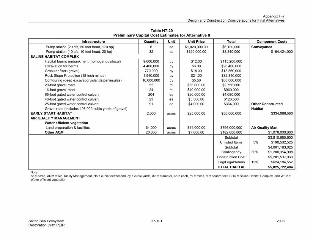
Appendix H-7 Design and Construction Considerations for Final Alternatives
Salton Sea Ecosystem H7-101 2006 Restoration Draft PEIR
Table H7-20 Preliminary Capital Cost Estimates for Alternative 8
Infrastructure Quantity Unit Unit Price Total Component Costs Pump station (20 cfs, 50 feet head, 170 hp) 6 ea $1,020,000.00 $6,120,000 Conveyance Pump station (10 cfs, 10 feet head, 20 hp) 32 ea $120,000.00 $3,840,000 $164,424,000 SALINE HABITAT COMPLEX Habitat berms embankment (homogenous/local) 9,600,000 cy $12.00 $115,200,000 Excavation for berms 4,400,000 cy $6.00 $26,400,000 Granular filter (gravel) 770,000 cy $18.00 $13,860,000 Rock Slope Protection (18-inch minus) 1,540,000 cy $21.00 $32,340,000 Contouring (deep excavation/islands/peninsulas) 16,000,000 cy $5.50 $88,000,000 20-foot gravel road 52 mi $53,000.00 $2,756,000 16-foot gravel road 24 mi $40,000.00 $960,000 65-foot gated water control culvert 204 ea $20,000.00 $4,080,000 40-foot gated water control culvert 23 ea $5,500.00 $126,500 25-foot gated water control culvert 91 ea $4,000.00 $364,000 Other Constructed Gravel road (includes 198,000 cubic yards of gravel) Habitat EARLY START HABITAT 2,000 acres $25,000.00 $50,000,000 $334,086,500 AIR QUALITY MANAGEMENT Water efficient vegetation Land preparation & facilities 64,000 acres $14,000.00 $896,000,000 Air Quality Man. Other AQM 26,000 acres $7,000.00 $182,000,000 $1,078,000,000 Subtotal $3,810,650,500 Unlisted Items 5% $190,532,525 Subtotal $4,001,183,025 Contingency 30% $1,200,354,908 Construction Cost $5,201,537,933 Eng/Legal/Admin 12% $624,184,552 TOTAL CAPITAL $5,825,722,484 Note: ac = acres, AQM = Air Quality Management, cfs = cubic feet/second, cy = cubic yards, dia = diameter, ea = each, mi = miles, sf = square feet, SHC = Saline Habitat Complex, and WEV = Water efficient vegetation