appendix i – burrowing owl mitigation and monitoring plan
TRANSCRIPT

Centinela Solar Energy, LLC I 7/27/2012
APPENDIX I – BURROWING OWL MITIGATION AND MONITORING PLAN

Burrowing Owl Mitigation and Monitoring Plan
FINAL
Centinela Solar Energy Project
Prepared for:
California Department of Fish and Game
Prepared by:
Heritage Environmental Consultants 2870 Emporia Court
Denver, Colorado 80238
April 2012

2
Table of Contents 1.0 Introduction ............................................................................................................................... 3
2.0 Status of Burrowing owls in the Project Area .......................................................................... 6
3.0 Impact Avoidance, Mitigation and Compensation ................................................................... 7
3.1 Risk Assessment ................................................................................................................... 7
3.2 Avoidance and Mitigation ..................................................................................................... 7
3.3 Compensation ....................................................................................................................... 9
3.3.1 Onsite Mitigation ......................................................................................................... 11
3.3.2 Offsite Mitigation ......................................................................................................... 11
3.3.3 NFWF .......................................................................................................................... 12
3.4 Artificial Burrows ............................................................................................................... 13
3.4.1 Below Ground Burrows ............................................................................................... 13
3.4.2 Aboveground Burrows ................................................................................................. 13
4.0 Monitoring and Reporting ....................................................................................................... 14
4.1 Monitoring .......................................................................................................................... 14
4.2 Reporting ............................................................................................................................. 14
4.3 Additional Construction and Operation Measures .................................................................. 15
4.3.1 Environmental Training ................................................................................................... 15
4.3.2 Conservation Funding ...................................................................................................... 15
5.0 Literature Cited ....................................................................................................................... 16
Attachment 1 – Burrowing Owl Survey Report (2011) ................................................................ 18
Attachment 2 – Active Burrow and Owl Count Summary (2009 – 2011) ................................... 19
Attachment 3 – CDFG Hay Bale Shelter-in-Place Guidance and Burrow Buffer Variance Table ....................................................................................................................................................... 20
Attachment 4 – Mitigation Mapbook ............................................................................................ 22
Attachment 5 – Burrowing Owl Mitigation Acreage Whitepaper ................................................ 23
Attachment 6 – REAT Cost Table ................................................................................................ 27

3
1.0 Introduction
Centinela Solar Energy, LLC (CSE) is proposing to build, operate and maintain a solar electric power generating facility and associated electrical line on private and federal lands in southern Imperial County. The proposed project consists of two primary components: (i) generation and associated facilities on privately owned land (the “CSE Facility”) and (ii) an approximately four-mile, 230-kilovolt (kV) aboveground, electrical line and associated facilities (the “Gen-tie Line”) that will electrically connect the CSE Facility on private land with the Imperial Valley Substation (or "IV Substation") located on federal land managed by the U.S. Department of the Interior, Bureau of Land Management (BLM). The CSE Facility and Gen-tie Line are referred to collectively as the “Project.” The area encompassing the CSE Facility and the Gen-tie Line is referred to as the “CSE Project Area.” CSE plans to begin construction on the Project during the second quarter of 2012. The general location of the Project is the Mount Signal area of Imperial County, approximately 8 miles southwest of the city of El Centro, Imperial County, California (Figure 1).
A total of 1,861 acres of active agricultural lands are expected to be permanently impacted as a result of project implementation. Construction of the Gen-tie Line would result in approximately 2.6 acres of permanent disturbance on native desert lands managed by the BLM. The agricultural fields and their associated irrigation infrastructure provide suitable habitat for Burrowing Owls (Athene cunicularia). Based on field studies conducted by Heritage Environmental Consultants, LLC (Heritage) between 2009 and 2011, the project has the potential to affect foraging habitat associated with up to 41 active Burrowing Owl burrows (Figure 2). No active burrows were identified within the Gen-tie Line right-of-way (ROW) on BLM-managed lands. It is anticipated that no active burrows will be removed by the Project. Burrowing Owls are designated a Species of Special Concern by the California Department of Fish and Game (CDFG) and are protected under California Fish and Game Code Sections 3503 and 3513 as well as the federal Migratory Bird Treaty Act (16 United States Code 703 et seq.).
CSE has developed this mitigation and monitoring plan to identify the reasonably foreseeable threats to the owls present in and immediately around the project area and develop measures to avoid, minimize, or mitigate these potential impacts.

ImperialValley
Substation
Southwest Powerlink (SWPL)
MEXICO
MEXICOUSA
Northern Corridor
Wormwood Lateral 3-A
Greeson Wash
Westside Main Canal
New River
Wista
ria C
anal
Wormwood Canal
Woodbine Canal
All American Canal
Wistaria Lateral 7
Wistaria Lateral 6
Mount Signal Drain
Wells
Drai
n
Elder Canal
Wood
bine L
ateral
2
Wistaria Lateral 5
Wistaria Lateral 4
Carpenter Drain
Fig Drain 1
Fig D
rain
Martin Drain
Gree
son D
rain 2
Wistaria Drain
Wood
bine L
ateral
7
Wista
ria D
rain 5
Mount Signal Drain 1
Wormwood Lateral 7
Wood
bine L
ateral
3
Brockman Drain
Euca
lyptus
Can
al
Fern Sidemain
All American Drain 13
Wistaria Lateral 8
Greeson DrainFe
rn C
anal
Moun
t Sign
al Dr
ain 1-
A
Wormwood Lateral 4
Elder
Later
al 1
Walnu
t Can
al
Dixie
Drai
n 3
Wistaria Lateral 2
Wood
bine L
ateral
4Wo
odbin
e Late
ral 8
Worm
wood
Can
al
Wistaria Lateral 7
Wormwood Canal
Moun
t Sign
al Dr
ain
OP98
OP29OP30
LYONS
DREW
KUBLER
STATE HWY 98
ANZA
BROC
KMAN
YUHA CUTOFF
HIME
SIGNA
L
SCHANIEL
PULL
IAM
COUN
TY H
WY S3
0
FISHER
GEORGE
WAHL
PRESTON
VOGE
LROCKWOOD
NICH
OLS
GRAHAM
WORM
WOOD
HARR
IGAN
VAN DER POEL
COOK
CONK
LING
DEARBORN
ROCK
WOOD
GRAHAM
ROCK
WOOD
°
12-20-11
California
Map Extent
Riverside Co.
San D
iego C
o.Im
peria
l Co.
SaltonSea
MEXICOUSA
Anza-BorregoDesert State
Park
ClevelandNationalForest State Plane Coordinate System
California Zone 6, NAD 83Lambert Conformal Conic Projection
1983 North American DatumLinear Unit: Foot US
0 0.5 1
Miles
Centinela SolarEnergy, LLC
Figure 1Project Location
Bureau of Land Management Land
Major Road
State Park Boundary
CSE Facility Parcel
! ! !Existing 500 kV Transmission Line
County Boundary
State Land
Cleveland National Forest Congressional Boundary
Indian Land
U.S. Forest Service Land
Major Water Body
! ! !Existing 230 kV Transmission Line
Department of Defense Land
Jurisdictional Land Ownership
Stream, Major Canal and/or Irrigation Canal
Legend
Alternative 3 Gen-tie Line Route
Ring Bus Switchyard

Southwest Powerlink (SWPL)
MEXICO
Wormwood Lateral 3-A
ImperialValley
Substation
Greeson Wash
Westside Main Canal
Wormwood Canal
Woodbine Canal
Wistaria Lateral 7
Mount Signal Drain
Wistaria Lateral 6
Wells
Drai
n
Wood
bine L
ateral
2
Fig Drain 1
Martin Drain
Gree
son D
rain 2
Wistaria Lateral 5
Wood
bine L
ateral
7
Wistaria Drain 5
Wistaria Lateral 4
Mount Signal Drain 1
Wistaria Canal
Brockman Drain
Wood
bine L
ateral
3
Greeson Drain
New River
Mount Signal Drain 1-A
Wormwood Lateral 4
Wistaria Drain
Wood
bine L
ateral
4Wo
odbin
e Late
ral 8
Mount Signal Drain 3
Wormwood Canal
Wistaria Lateral 7
Worm
wood
Can
al
Moun
t Sign
al Dr
ain
OP98
OP29
OP30
LYONS
DREW
KUBLER
STATE HWY 98
ANZA
BROC
KMAN
YUHA CUTOFF
COUN
TY H
WY 29
FISHER
COUN
TY H
WY S3
0
SIGNA
L
WAHL
ROCKWOOD
PRESTON
PULL
IAM
WORM
WOOD
VOGE
L
DEARBORN
HARRIGAN
ROCK
WOOD
ROCK
WOOD
ROCK
WOOD
°
12-20-11
California
Map Extent
Riverside Co.
San D
iego C
o.Im
peria
l Co.
SaltonSea
MEXICOUSA
Anza-BorregoDesert State
Park
ClevelandNationalForest State Plane Coordinate System
California Zone 6, NAD 83Lambert Conformal Conic Projection
1983 North American DatumLinear Unit: Foot US
0 0.5 1
Miles
CentinelaSolar Energy, LLC
Figure 2Burrowing OwlOccurrences
Bureau of Land Management Land
Major Road
State Park Boundary
CSE Facility Parcel
! ! !Existing 500 kV Transmission Line
County Boundary
State Land
Cleveland National Forest Congressional Boundary
Indian Land
U.S. Forest Service Land
Major Water Body
! ! !Existing 230 kV Transmission Line
Department of Defense Land
Jurisdictional Land Ownership
Stream, Major Canal and/or Irrigation Canal
Legend
Alternatve 3 Gen-tie Line Route
Existing Access RoadNew Access RoadTemporary Access Road
Temporary Work AreaPulling & Tensioning AreaWire Splicing SiteGuard Structure
CSE Facility Disturbance Area
CSE Study Area
Active Burrow within CSE Study Area
Ring Bus Switchyard

6
2.0 Status of Burrowing owls in the Project Area
Heritage conducted protocol Burrowing Owl surveys in accordance with the 1993 California Burrowing Owl Consortium’s (CBOC) Burrowing Owl Survey Protocol and Mitigation Guidelines ([CBOC Guidelines] CBOC 1993) and the CDFG Staff Report on Burrowing Owl Mitigation (CDFG 1995). Surveys were completed during the 2009 and 2011 breeding seasons as well as the 2009/2010 winter season.
Surveys were conducted within the project area and a 500-foot buffer surrounding the project area. The Phase I habitat assessments determined that most of the study area contains suitable Burrowing Owl habitat. These areas were subsequently evaluated using the Phase II and III survey techniques. Survey dates, times, weather conditions, and results are provided in the attached Heritage survey report (Heritage 2011; Attachment 1).
Forty-eight active Burrowing Owl burrows were detected within the study area during the surveys (Figure 2). All burrows were observed or assumed to be attended by a pair (2) of Burrowing Owls. Cooperative breeding has not been observed in the species (Haug et al. 1993) and no more than 2 adults were ever suspected to be associated with any burrow in the study area. In several instances, only one adult was ever observed at a given burrow. However, without a mark-recapture or color banding study, it is not possible to confirm that these represent instances of an unpaired adult. Therefore, for the purposes of this plan, all adult owls within the project area are assumed to be paired, and the term “active burrow” should be interpreted to represent a “breeding pair” throughout this document. As such, the 48 active burrows represent up to 96 adult Burrowing Owls occupying the study area. Attachment 2 provides the number of owls counted at each burrow on each survey day (including juvenile owls).
Winter surveys confirmed that Burrowing Owls continue to use the site during the non-breeding season, though in significantly lower densities (Heritage 2011; Attachment 1). It is unclear if these birds represent year-round residents or migratory individuals that winter in the project area but breed farther north.

7
3.0 Impact Avoidance, Mitigation and Compensation
3.1 Risk Assessment The 1995 CDFG Staff Report on Burrowing Owl Mitigation defines an impact to burrowing owl as:
• Disturbance within 50 meters (approximately 160 feet) which may result in harassment of owls at occupied burrows;
• Destruction of natural and artificial burrows (culverts, concrete slabs, and debris piles that provide shelter to burrowing owls); and,
• Destruction and/or degradation of foraging habitat adjacent (within 100 meters, or about 300 feet) of an occupied burrow(s).
As described in Section 2.0, there are 48 active burrows (representing up to 96 adult Burrowing Owls) located within the study area. Direct removal of these burrows is not anticipated as the result of project implementation. Agricultural fields, which represent suitable foraging habitat for many of these burrows, will be disturbed during construction activities.
In accordance with the CDFG Staff Report on Burrowing Owl Mitigation (1995), impacts to foraging habitat within 100 meters (approximately 300 feet) of each active burrow would require mitigation. Project implementation would result in the reduction of foraging habitat within 100 meters of up to 41 active burrows within the study area.
3.2 Avoidance and Mitigation The following measures are described as part of Mitigation Measure B3 from the Final Environmental Impact Report for the Centinela Solar Energy Project (EGI 2011) and will avoid, minimize, or mitigate potential impacts to Burrowing Owl during construction activities:
1. To the extent practicable, initial grading and clearing within the project footprint should take place between September 1 and January 31 to avoid impacts to any breeding Burrowing Owls. Occupied burrows should not be removed during the nesting season (February 1 through August 31) unless a qualified biologist approved by CDFG verifies through non-invasive methods that either (a) the birds have not begun egg-laying and incubation; or (b) that juveniles from the occupied burrows are foraging independently and are capable of independent survival. If initial grading and clearing within the project footprint is to begin during the breeding season (February 1 through August 31), the following measures (#2 and #3 below) will be implemented.
2. Within 30-days prior to initiation of initial grading and clearing, pre-construction clearance surveys for this species shall be conducted by qualified and agency-approved

8
biologists to determine the presence or absence of this species within the grading area. The proposed grading areas shall be clearly demarcated in the field and via GPS by the project engineers and Designated Biologist prior to the commencement of the pre-construction clearance survey. The surveys shall follow the protocols provided in the Burrowing Owl Survey Protocol and Mitigation Guidelines (CDFG 1995).
3. When removal of occupied burrows is unavoidable (this is not anticipated for the Project), the following mitigation measures shall be implemented outside of the breeding season. Passive relocation methods are to be used by the biological monitors to move the owls out of the impact zone. This includes covering or excavating all burrows and installing one-way doors into occupied burrows. This will allow any animals inside to leave the burrow, but will exclude any animals from re-entering the burrow. A period of at least one week is required after the relocation effort to allow the birds to leave the impacted area before excavation of the burrow can begin. The burrows should then be excavated by hand and filled in to prevent their reuse. The removal of active burrows on-site requires construction of new burrows or the enhancement of existing unsuitable burrows (i.e., enlargement or clearing of debris) at least one week prior to passive relocation efforts. Burrow mitigation will occur at a ratio of 2:1 at least 50 meters from the impacted area and burrows must be constructed as part of the above-described relocation efforts.
4. These measures shall be implemented if passive relocation of some burrows in accordance with the procedures listed above is determined to be an unfavorable alternative for BUOW and occupied burrows are near construction activities: During the BUOW nesting season (February 1 to August 31), the qualified biologist shall establish and mark a 250 foot non-disturbance buffer circle around the burrow. The buffer shall be staked and roped-off prior to initiating any construction activity. No activity shall take place within the avoidance buffer area to ensure that disturbance to nesting birds does not occur. Any disturbance to nesting BUOW would require prior consultation, approval and mitigation in accordance with California Fish and Game requirements.
Construction activities may occur, and temporary and/or permanent infrastructure may be installed, operated, and maintained within 75 meters of an occupied burrow during the breeding season in certain cases, and within 50 meters of an occupied burrow during the non-breeding season. If activity within 75 meters of an occupied burrow becomes necessary during the breeding season, shelter-in-place strategies (described in Attachment 3) would be employed. Requested burrow buffer variances are also described in Attachment 3. Passive relocation measures (described above) could be employed as discussed above, but such measures are not currently anticipated.

9
3.3 Compensation Up to 41 active burrows (up to 82 adult Burrowing Owls) could experience impacts within the prescribed 300-foot buffer (Attachment 4). CSE has agreed to provide compensatory mitigation for these impacts.
The CSE Project is proposed to be constructed in phases. Construction of the initial phase, totaling 175 megaWatts (MW) of capacity and designated as “Phase Ia” and “Phase Ib”, is anticipated to begin during the second quarter of 2012; however, the construction schedule for future expansion (e.g., Phase II) has not been determined. Limited components of the Project that do not impact BUOW (e.g., the onsite switchyard or Gen-tie Line) may be constructed at any time, without preconstruction compensatory mitigation for BUOW. In the interim between start of construction of the initial phase and subsequent future expansion, fields not developed during the initial phase will continue to be used for agricultural purposes. The initial phase of construction would only impact a subset of the 41 burrows potentially impacted by the complete project. Compensatory mitigation and artificial burrow construction described in Sections 3.3 and 3.4 would apply to impacts associated with the initial phase of construction in the near term, and mitigation for impacts associated with future expansion would take place no later than 30 days prior to construction commencing on the future expansion areas.
Because of the semi-colonial nature of Burrowing Owls (Poulin et al. 2011), as well as the high degree of home-range overlap reported in the literature (Poulin et al. 2011, DeSante et al. 2004, Rosenberg and Haley 2004) and observed within the CSE study area (Heritage 2011), CSE calculated mitigation requirements at the scale of Burrowing Owl “colonies” rather than for each burrow individually. Mitigation acreages were based on the area within a 300-foot radius of active burrows without counting areas of overlap twice. Put differently, if the 300-foot radii around two or more burrows overlapped, the radii were merged to create a single polygon and the combined mitigation acreage for the clustered burrows was based on the area of that polygon. Mitigation acreage for isolated burrows (i.e., at least 300 feet from a neighboring burrow) was calculated using the entire 300-foot radius. This method was employed to account for the high densities of owls present in the project area and the high degree of overlapping foraging areas reported for agro-ecosystems, especially the Imperial Valley. Attachment 5 provides a more detailed explanation of Burrowing Owl home-ranges and how this mitigation strategy described above was derived.
CSE will mitigate for all of the land within the merged-polygons for any burrow that would experience impacts within the burrow’s 300 foot buffer area. Table 1 describes the required mitigation acreages for all phases of construction on each page of the Mitigation Mapbook (Attachment 4).

10
Table 1 – Burrowing Owl Mitigation Acreages (All Phases)
Mapbook Page Burrow IDs
Mitigation Acreage
1 29, 31, 52, 55, 56, 59 21.3 2 24-28, 32-35 30.0 3 23, 43 7.4 5 22 6.5 8 40 6.5 9 37 6.5 10 16 6.5 11 1, 2, 17, 18, 19 15.6 12 3, 62 9.6 13 45, 46, 50, 54, 63 28.1 14 47, 48, 49, 53 12.7 14 51 6.5 15 41 6.5 15 44 6.5 16 42 6.5
Total: 176.7
Because lands associated with future expansion would remain in agricultural use during construction of the initial phase, it is possible that Burrowing Owls occupying lands associated with the initial phase could be displaced and could disperse to lands associated with future expansion. Thus, in the period between construction of the initial phase and future expansion of the Project, the locations and numbers of active burrows could change as a result of the construction of the initial phase. If future expansion construction is scheduled to begin two or more years following the completion of site preparation work associated with the initial phase, a new protocol Burrowing Owl survey following CBOC Guidelines (1993) would be required, and mitigation acreages would be recalculated based on the results of that survey.
Prior to initiating ground-disturbing activities within BUOW foraging habitat associated with the phases described above, CSE will provide compensatory mitigation for the BUOW foraging habitat to be disturbed by that phase of construction in accordance with the acreages listed in Table 1 above or provide security for implementation of mitigation in accordance with Section 3.3.4. At least 30 days prior to initiating such ground-disturbing activities within the phases described above, CSE will provide a notification to CDFG that includes 1) a listing of the specific burrows to be impacted by the phase of construction; 2) the compensatory mitigation acreage provided for each burrow in accordance with Table 1 above. Prior to initiating ground-

11
disturbing activities within BUOW foraging habitat, CSE shall provide documentation that compensatory mitigation requirements for the phase of construction have been satisfied in accordance with Section 3.3.1, 3.3.2, or 3.3.3 below; alternatively, CSE may elect to provide security for implementation of mitigation in accordance with Section 3.3.4. Consistent with these requirements, prior to applicable construction of Phase Ia, CSE shall satisfy the compensatory mitigation requirements of Section 3.3.1, 3.3.2, or 3.3.3 below and shall provide the required 30-day notification to CDFG, or CSE shall provide security for implementation of mitigation in accordance with Section 3.3.4. The same procedures will be implemented prior to construction of Phase Ib. Note that at least 90 days prior to construction of any phase following Phase Ib, CSE shall coordinate with CDFG on the strategy for providing compensatory mitigation (e.g., lump sum, multiple phases, etc.).
CSE intends to use a combination of on-site mitigation, off-site mitigation and National Fish and Wildlife Foundation’s (NFWF’s) Impact-Directed Environmental Accounts program, as described below (any of these options could be used in any proportion to satisfy the total compensatory mitigation acreage requirement). The options for compensatory mitigation are described below.
3.3.1 Onsite Mitigation The compensatory mitigation acreage may include protection of foraging habitat on the CSE project site. Foraging habitat would be protected through an agricultural preservation easement (or similar conservation mechanism) that restricts use of the land to cultivation of field crops (e.g., alfalfa, grain or bermuda grass) that provide suitable foraging habitat for Burrowing Owls. If practicable, on-site mitigation lands would be consolidated as a single parcel and located on the edge of the proposed CSE Facility (i.e., the mitigation area would not be surrounded by project related infrastructure). Otherwise, multiple on-site mitigation parcels located on the edge of the CSE Facility could be implemented with CDGF’s concurrence.
3.3.2 Offsite Mitigation If the off-site mitigation option is utilized, CSE will purchase an agricultural conservation easement (or provide a similar conservation mechanism) on nearby farmland. As with the onsite mitigation, the conservation easement would restrict use and crop types on the land. If conservation lands are acquired directly by CSE, those lands may be managed by CSE, or they may be transferred in fee title to CDFG, a CDFG approved non-profit organization qualified pursuant to California Government Code section 65965, or other government entity with either a conservation easement, deed restriction, or other protective measures (as approved by CDFG) over those lands. If lands are transferred to CDFG, CSE will reimburse CDFG for reasonable expenses incurred during title and documentation review, expenses incurred from other state agency reviews, and overhead related to transfer of the lands. Alternatively, CSE may secure offsite mitigation lands via an approved conservation group, a

12
similar approved organization that accepts and administers compensatory funds, an approved offsite mitigation fund, or an approved mitigation bank in the future, if one becomes available.
3.3.3 NFWF To the extent that the on-site or CSE initiated off-site mitigation options are not selected to satisfy compensatory mitigation requirements, CSE would secure the remaining mitigation needs by depositing funds with NFWF. Funds for the acquisition of the land would be remitted in an amount determined by the acreage of foraging habitat impacts to be mitigated under this plan. The direct land acquisition funds are to be assessed based on current fair market appraised value for the specific geographic area in which the acquisition occurs. The Renewable Energy Action Team (REAT) Cost Table (September 2010, Attachment 6) provides estimates of fees for land acquisition and land management. Funds remitted to NFWF would be placed into the account governed by the REAT/NFWF MOA (REAT/NFWF MOA 2010).
If funds are provided to NFWF, the compensation: (1) funds will be provided no later than 30 days prior to ground disturbance within BUOW foraging habitat; (2) lands will be acquired no later than 2 years after ground-disturbing activity within BUOW foraging habitat; and (3) lands will be conserved by a legal mechanism agreed to by DFG. The management fund shall be secured by CSE and will consist of an interest-bearing account with the amount of capital sufficient to fund all monitoring, management, and protection of the acquired lands, including reasonable administrative overhead, biological monitoring, and law enforcement measures. A Property Analysis Record, or comparable method, will be conducted by CSE and reviewed by DFG, to determine the management needs and costs described above, which then will be used to calculate the amount of capital needed for the management fund. This long-term management and monitoring fund will be held and managed by an entity approved by DFG.
3.3.4 Security for Implementation of Mitigation.
CSE may proceed with ground-disturbing activities within BUOW foraging habitat before completing all of the required mitigation (including acquisition of lands), monitoring, and reporting activities by ensuring funding to complete those activities. They will provide to DFG, within 30 days prior to the Project commencing ground-disturbing activities within BUOW foraging habitat, an irrevocable letter of credit or another form of security (security) approved by DFG’s Office of General Counsel. The security will allow DFG to draw on the principal sum if DFG, at its sole discretion, determines the Applicant has failed to comply with the conditions set forth herein. Even if the security is provided, CSE must complete the required acquisition, protection, and monitoring of all lands and record the required agricultural preservation easements, or other protection measures no later than 2 years after the start of ground disturbing activities within BUOW foraging habitat.

13
Based on the mitigation ratios established as part of the proposed action, the security required for the Applicant will be in the amount of $1,016,025 based on the following acreage-based estimated costs of implementing the mitigation, monitoring, and reporting requirements:
o Land acquisition costs for impacts to habitat, calculated at $5,000.00/acre for 176.7 acre, are $883,500;
o Long-term maintenance and management costs, calculated at $750.00/acre, are $132,525.
The Applicant has indicated that it will construct the Project in phases and will post security for the mitigation costs associated with each phase prior to ground construction for that phase as follows:
o Security for Phase Ia will be in the amount of $566,375 for 98.5 acres; o Security for Phase Ib will be in the amount of $112,125 for 19.5 acres; o Security for Phase II will be in the amount of $337,525 for 58.7 acres;
3.4 Artificial Burrows Based on current survey results and project plans, no burrows would be directly impacted by the Project; however, if pre-construction surveys show that burrows would be directly impacted, artificial burrows would be created on mitigation lands at a ratio of 2:1. Artificial burrows would be either below ground or above ground.
3.4.1 Below Ground Burrows A backhoe or similar heavy equipment would be used to dig a trench for the burrow entrance and exit openings, access-way, and a nesting chamber. Artificial burrows would be constructed based on site conditions and would generally follow accepted methodologies such as Barrett (2009) or other suitable methodologies.
3.4.2 Aboveground Burrows For an aboveground burrow, the artificial nest chamber and entrance tubes would be the same as for an underground burrow, except these items would be arranged flat on the ground. Soil would be applied by hand to keep the nest chamber and tubes in place before a backhoe is used to build a 5-foot-high mound on top of the artificial nest features to provide comparable temperature stability to an underground burrow.
For both below- and aboveground burrows, perches may be erected near the artificial burrows to provide safe perch locations for burrowing owls and to potentially reduce the distance owls would move away when disturbed. Perches would consist of wooden “T” stakes inserted into the ground or other materials that would be suitable for each artificial burrow site.
Additionally, to shield the artificial burrows from mammalian nest predators such as coyotes and feral dogs, artificial burrows would be armored with rocks placed in such a way as to protect the tunnels and nest chambers.
14
4.0 Monitoring and Reporting
4.1 Monitoring On-site and off-site mitigation lands would be monitored for a period of 5 years to determine if owls are using them. Monitoring methodologies would follow CBOC Guidelines (1993) and would target the peak of the breeding season (April 15 to July 15)_to the extent practical. Monitoring would include both a breeding season survey and a winter survey in each of the years (four visits for each survey).
Compensatory mitigation accomplished through the NFWF option would include monitoring as part of the NFWF contribution, and CSE would not be responsible for the implementation of monitoring on NFWF mitigation lands.
4.2 Reporting Annual monitoring reports will be submitted to CDFG and BLM for the duration of the monitoring period described in Section 4.1 above and will summarize all monitoring activities undertaken and the status of all Burrowing Owls observed on onsite mitigation lands as well as the CSE project area. Reports will include the date, time and weather conditions during surveys, the location of any Burrowing Owl observations or burrows with Burrowing Owl sign (scratches, pellets, whitewash, prey items, etc.), the number of adult and juvenile birds observed at each suspected active burrow, and general notes on foraging behaviors relative to the burrow.

15
4.3 Additional Construction and Operation Measures
4.3.1 Environmental Training CSE will provide a Worker Environmental Education Program to all personnel working onsite prior to such personnel commencing any construction activities. The training will include, at a minimum, a review of Burrowing Owl identification and ecology, state and legal status of the species, guidelines on what to do if an owl is encountered during construction, and who to contact in case there any issues. This program will help promote awareness and facilitate implementation of appropriate measures for Burrowing Owls on the site.
4.3.2 Conservation Funding Funding for all activities proposed by this plan will be provided by CSE. On-site and off-site compensatory mitigation will be guaranteed with a security, letter of credit, or other financial mechanism if the requisite conservation easement cannot be acquired prior to the start of construction.

16
5.0 Literature Cited
Barrett Biological Surveys (Barrett). 2009. Burrowing Owl Artificial Burrow Installation Manual. Imperial Irrigation District. September 2009. 9 pages.
California Burrowing Owl Consortium (CBOC). 1993. Burrowing Owl Survey Protocol and Mitigation Guidelines. 15 pages.
California, State of. 1995. Staff Report on Burrowing Owl Mitigation. Department of Fish and Game. October 17, 1995.
DeSante, D. F., E. D. Ruhlen and D. K. Rosenberg. 2004. Density and abundance of Burrowing Owls in the agricultural matrix of the Imperial Valley, California. Studies in Avian Biology 27: 116-119.
EGI. 2011. Final Environmental Impact Report for the Centinela Solar Energy Project. Prepared for the County of Imperial and Bureau of Land Management. December, 2011.
Haug, E. A., B. A. Millsap and M. S. Martell. 1993. Burrowing Owl (Athene cunicularia), The Birds of North America Online (A. Poole, Ed.). Ithaca: Cornell Lab of Ornithology; Retrieved from the Birds of North America Online: http://bna.birds.cornell.edu.bnaproxy.birds.cornell.edu/bna/species/061doi:10.2173/bna.61
Heritage Environmental Consultants (Heritage). 2011. Centinela Solar Energy Protocol Burrowing Owl Survey Report 2009-2011. May, 2011.
Poulin, Ray, L. Danielle Todd, E. A. Haug, B. A. Millsap and M. S. Martell. 2011. Burrowing Owl (Athene cunicularia), The Birds of North America Online (A. Poole, Ed.). Ithaca: Cornell Lab of Ornithology; Retrieved from the Birds of North America Online: http://bna.birds.cornell.edu.bnaproxy.birds.cornell.edu/bna/species/061doi:10.2173/bna.61.
Rosenberg, D. K. and K. L. Haley. 2004. The ecology of Burrowing Owls in the agroecosystem of the Imperial Valley, California. Studies in Avian Biology 26: 120-135.

Attachments
Attachment 1 – Burrowing Owl Survey Report (2011)

Centinela Solar Energy, LLC Protocol Burrowing Owl Survey Report 2009 - 2011
Phase I, II and III Survey Report
Prepared for:
Centinela Solar Energy, LLC c/o LS Power Development, LLC 5000 Hopyard Road, Suite 480 Pleasanton, California 94588
Prepared by:
Heritage Environmental Consultants, LLC 2870 Emporia Court Denver, Colorado 80238
June 2011

i | P a g e
Table of Contents TABLE OF CONTENTS ................................................................................................................... I 1.0 PROJECT OVERVIEW .......................................................................................................... 2 2.0 INTRODUCTION ................................................................................................................. 3 3.0 STUDY AREA ...................................................................................................................... 4 4.0 SURVEY METHODS ............................................................................................................. 5
4.1 PHASE I AND PHASE II SURVEYS ............................................................................................. 5 4.2 PHASE III SURVEYS .............................................................................................................. 5
5.0 SURVEY RESULTS ................................................................................................................ 6 5.1 PHASE I AND II SURVEYS ....................................................................................................... 6 5.2 PHASE III SURVEYS .............................................................................................................. 6
7.0 REFERENCES ..................................................................................................................... 15 APPENDIX A – ACTIVE AND INACTIVE BURROW SUMMARY ..................................................... 16
List of Tables
Table 1 Phase I and Phase II Surveys Table 2 Phase III Surveys Table 3 Active Burrow Summary
List of Figures
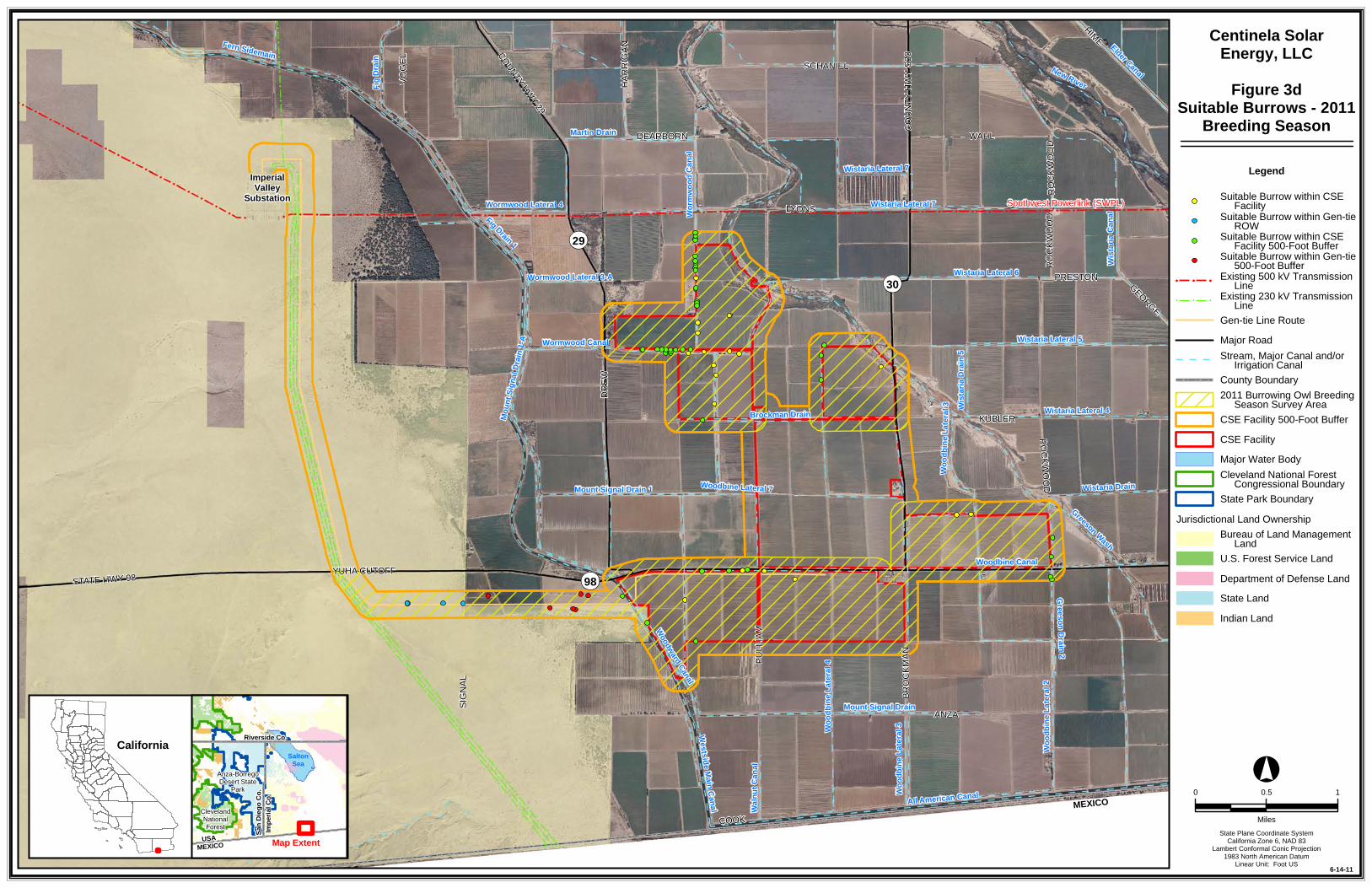
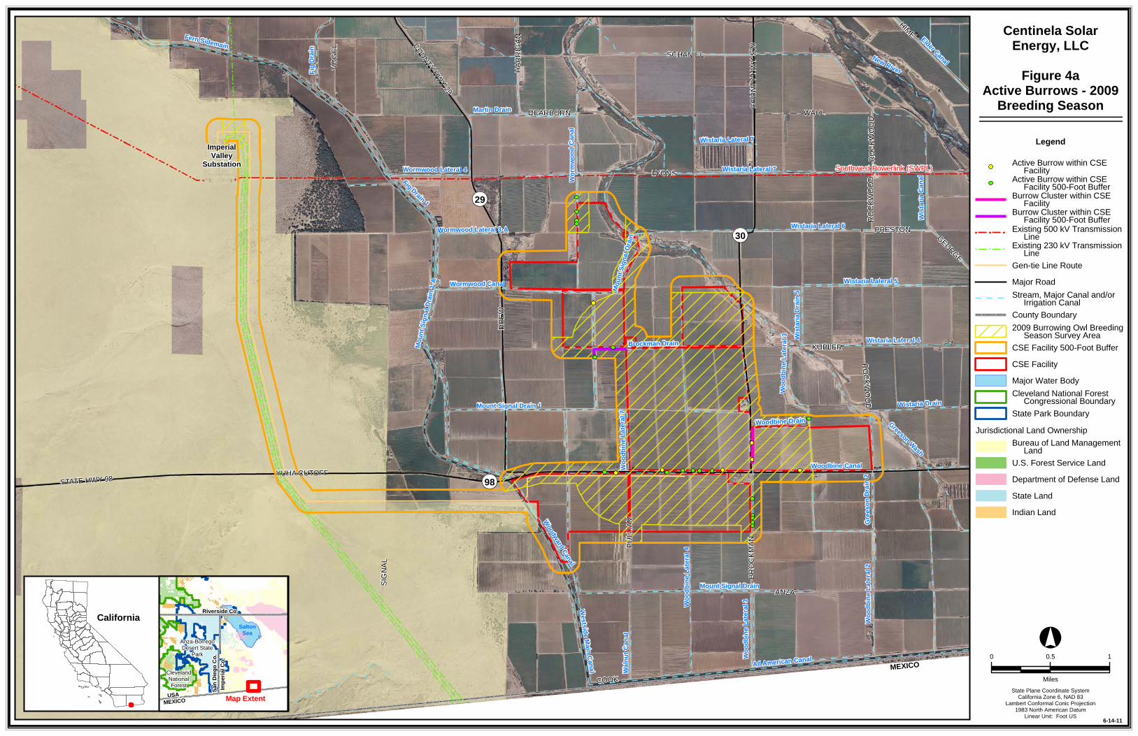
Figure 1 Project Location Figure 2 Study Area Figure 3a Suitable Burrows – 2009 Breeding Season Figure 3b Suitable Burrows – 2009/2010 Winter Season Figure 3c Suitable Burrows – 2010 Breeding Season Figure 3d Suitable Burrows – 2011 Breeding Season Figure 4a Active Burrows – 2009 Breeding Season Figure 4b Active Burrows – 2009/2010 Winter Season Figure 4c Active Burrows – 2010 Breeding Season Figure 4d Active Burrows – 2011 Breeding Season

2 | P a g e
1.0 PROJECT OVERVIEW Western Burrowing Owls (Athene cunicularia hypugea) are common in Imperial County and were identified as a species of interest during the early planning stages for the solar electric power generating facility and associated electric line proposed by Centinela Solar Energy, LLC (CSE). The project is located in Imperial County, approximately eight miles southwest of El Centro, California, and would use Photovoltaic (PV) technology to produce up to approximately 275 megawatts (MW) of electricity on 2,067 acres of private land (CSE Facility), 1,861 acres of which are actively cultivated farmland. The CSE Facility is generally bordered by the Westside Canal on the west and Greeson Wash on the east (Figure 1).
The project also includes approximately 7 miles of 230-kilovolt (kV) overhead electric line (Gen-tie Line) to electrically interconnect the CSE Facility with the nearby Imperial Valley Substation. The Gen-tie Line will originate at the CSE Facility substation, located immediately south of Highway 98 and approximately ½ mile east of Pulliam Road, and extend approximately 1.5 miles generally west through the CSE Facility site. From the western boundary of the CSE Facility site, the Gen-tie Line would extend across the West Side Main Canal and continue approximately 1.25 miles through private agricultural lands south of Highway 98. The remaining approximately 4.25 miles extends through federal lands managed by the Bureau of Land Management (BLM), first west then north, to connect with the Imperial Valley Substation (Figure 1). The proposed ROW width on lands managed by BLM is 125 feet. Alternatives for the proposed project are all located within the survey area. The CSE Facility and Gen-tie Line are collectively referred to as the CSE Project and encompass and area referred to as the CSE Project Area.
The purpose of the surveys was to identify Burrowing Owl nests on or near the CSE Facility, within the Gen-tie Line ROW, and associated buffers (see Section 3.0).

3 | P a g e
2.0 Introduction The California Department of Fish and Game (CDFG) Inland Deserts Region was contacted in April 2009 to determine if surveys should be conducted prior to an environmental analysis. Craig Weightman, Senior Environmental Scientist, CDFG requested that the surveys be conducted prior to any permitting so the results could be used as a baseline for the environmental analysis (Weightman 2009).
The Burrowing Owl is a California Species of Special Concern and a BLM sensitive species. It is protected by the Migratory Bird Treat Act (MBTA) and California Fish & Game Code §§ 3503, 3503.5, 3513. Nesting occurs from March through August. Burrowing Owls typically form a pair-bond for more than 1 year and exhibit high site fidelity, reusing the same burrow year after year (Haug et al. 1993). The female remains inside the burrow during most of the egg laying and incubation period and is fed by the male throughout brooding. Burrowing Owls are opportunistic feeders, consuming a diet that includes arthropods (typically insects), small mammals, small birds, and occasionally amphibians and reptiles (Haug et al. 1993). Urbanization has greatly reduced the amount of suitable habitat for this species. Other contributions to the decline of this species include the poisoning of squirrels and prairie dogs, and collisions with automobiles. A survey effort carried out between 1991 and 1993 indicated that major population densities in California remain in the Central and Imperial valleys (DeSante et al.1996), where this species is a year-round resident in Imperial County.
The Burrowing Owl is primarily restricted to the western United States and Mexico. Habitat for the Burrowing Owl includes dry, open, short-grass areas often associated with burrowing mammals (Haug et al. 1993). In Imperial County it is found in desert scrub, grasslands, and agricultural areas, where it digs its own or occupies existing burrows.
The California Burrowing Owl Consortium (CBOC) developed a Survey Protocol and Mitigation Guidelines (CBOC 1993) to meet the need for uniform standards when surveying Burrowing Owl populations and evaluating impacts from development projects. These guidelines are generally accepted by the California Department of Fish and Game (CDFG) and are intended to provide a decision-making process that should be implemented wherever there is potential for an action or project to adversely affect Burrowing Owls or the resources that support them. The CDFG recommended that CSE follow these guidelines for this survey (Weightman 2009).
The CBOC guidelines suggest Burrowing Owl surveys be conducted in three phases. The purpose of a Phase I survey is to assess the presence of Burrowing Owl habitat in the project area. Phase II surveys are necessary to determine if suitable burrows occur on the site. Phase III surveys are intended to characterize owl presence during the nesting season and/or during winter. This report presents the findings of the Phase I, II, and III surveys within the proposed CSE Facility, proposed Gen-tie Line corridor, and associated buffers (see Section 3.0).

4 | P a g e
3.0 Study Area The study area is comprised of three main components: (1) the 2,067-acre CSE Facility; (2) the 7-mile Gen-tie Line corridor; and (3) a 500-foot buffer surrounding both the CSE Facility and the Gen-tie Line.
The CSE Facility site is primarily active agricultural lands growing crops such as alfalfa, Sudan grass, and Bermuda grass. Native vegetation on the site is generally absent with a few exceptions. The fields on the site are ringed by a series of earthen and concrete canals and drains that provide irrigation and drainage for the fields. Sporadic, very limited riparian and wetland vegetation occur along portions of the earthen canals and berms. This vegetation is a mixture of native and non-native species and includes arrow weed (Pluchea serricea), cattails (Typha sp.), tamarisk (Tamarix ramosissima), bitter dock (Rumex obtusifolius), and sprangletop (Leptochloa sp.). Routine maintenance of these drains and canals by the Imperial Irrigation District (IID) involves the periodic removal of vegetation to maintain uninhibited water flow. Since vegetation clearing is a routine activity, the wetland vegetation is always sparse and not well developed. Removal of this vegetation also provides suitable Burrowing Owl habitat once mammals return to these areas and excavate burrows; therefore, Burrowing Owl habitat in the project area is regularly changing, including creation of new burrow sites and loss of existing burrow sites. Topography in the study area is generally flat.
The Gen-tie Line crosses approximately 2.75-miles of active agricultural land that is similar to the CSE Facility. The remaining 4.25-miles of the Gen-tie Line crosses native desert within the Yuha Basin. This area is generally flat Colorado Desert that is intersected by several small ephemeral washes. Most habitats within this portion of the Gen-tie route are dominated by creosote bush – white bursage (Larrea tridentate – Ambrosia dumosa) scrub, smoke tree (Psorothamnus spinosus) wash scrub, encelia (Encelia frutescens ssp. frutescens) – white bursage scrub, developed/disturbed areas, white bursage – disturbed, mesquite – catclaw (Prosopis glandulosa var. torreyana – Acacia greggii)/mesquite bosques, desert pavement, and non-vegetated sandy wash.

5 | P a g e
4.0 Survey Methods 4.1 PHASE I AND PHASE II SURVEYS
Phase I and Phase II surveys were conducted simultaneously by qualified biologists during the breeding season (March-August), according to the CBOC guidelines (1993). The Phase I habitat assessments determined that most of the study area contains suitable Burrowing Owl habitat, and Phase II burrow surveys were conducted.
Phase II surveys covered the entire study area and potentially suitable burrows were recorded. Transects at 30-meter spacing were walked along the Gen-tie Line corridor to ensure that all suitable burrows were identified, including a 500-foot buffer around the project area.
Burrows that had the potential to be used by Burrowing Owls were marked using a handheld global positioning system (GPS) unit. Photos were taken of representative potential burrows, and owl observations were noted. “Burrow Clusters” were recorded in areas that supported higher densities of burrows to minimize the number of GPS points for potentially suitable burrows.
4.2 PHASE III SURVEYS
The Burrowing Owl nesting season begins as early as February 1 and continues through August 31 (Thomsen 1971, Zam 1974). The timing of nesting activities varies with latitude and climatic conditions. Phase III surveys were conducted during the breeding season, beginning March 1 through August; a winter survey was also conducted on a portion of the study area in January 2010. All Burrowing Owl sightings were recorded (including occupied burrows and burrows with sign) and mapped (Figures 3a-d). Numbers of adults and juveniles were recorded, as well as behavior such as courtship and copulation. Territory boundaries and foraging areas were not mapped, mainly because of the difficulty posed by the active nests being so close together where home-ranges potentially overlap.
Surveys were conducted in the morning and evening (one-half hour before to two hours after sunrise and two hours before to one-half hour after sunset). Burrows were examined for owl sign during the first observation of suitable burrows during Phase III surveys and occupied burrows were mapped. Subsequent observations were conducted from fixed points that provided visual coverage of the burrows using spotting scopes or binoculars. Observers remained in the vehicle to minimize disturbance to the birds as much as possible.

6 | P a g e
5.0 Survey Results 5.1 PHASE I AND II SURVEYS
In its current condition, the study area and surrounding areas were observed to contain suitable nesting habitat for Burrowing Owls. The survey area contains both natural and artificial burrows. Observed burrow densities in native habitats along the Gen-tie Line on BLM-managed lands are significantly lower than in agricultural habitats, many burrows are too small to be suitable, and none are active. The natural burrows were most commonly associated with slopes along berms, canals, or drains where soil conditions are apparently more suitable for burrow construction. In the absence of suitable natural burrows, Burrowing Owls have been known to nest in man-made features. Numerous man-made features in the study area also provide suitable artificial burrow opportunities, including concrete and metal culverts and irrigation pipes.
Phase I and II surveys were conducted between the spring of 2009 and the spring of 2011 because the project area was expanded and the Gen-tie Line route was refined. Table 1 lists dates, times, and weather for the Phase II surveys. One-hundred and eight potentially suitable burrows were identified during the Phase II surveys (Figure 3; Appendix A).
Table 1. Phase I and Phase II Surveys Date Time Weather Conditions May 18, 2009 1300-1925 111°F; clear, calm May 19, 2009 1030-1700 100°F; clear, calm May 20, 2009 1400-1608 113°F; clear, calm June 16, 2009 1441-1600 85°F; partly cloudy, calm July 5, 2010 0715-1400 67-95°; clear, calm January 4, 2010 1030-1430 73°F, clear, calm January 5, 2010 1015-1300 72°F, clear calm March 21, 2011 1130-1845 63°F, clear, windy (25 mph) March 22, 2011 0655-1658 44-71°F, clear, calm
5.2 PHASE III SURVEYS
Table 2 lists dates, times, weather, and visibility for the Phase III surveys. Due to the number of active burrows and individuals observed, data for each active burrow have been included in Appendix A. Table 3 summarizes the results of the Phase III survey and breaks down results by study area component. Figure 4 shows the location of the active burrows. To the maximum extent practicable, active burrows were surveyed in reverse order during each round of Phase III surveys so that owls could be observed at different times of the day during each survey period.

Survey Results
7 | P a g e
Table 2. Phase III Surveys Date Time Weather Conditions May 19, 2009 0450-0915
1730-2015
73°F; clear, calm
100°F; clear, calm May 20, 2009 0500-0857
1636-2001
70°F; partly cloudy, calm
113°F; clear, calm May 21, 2009 0512-0855 75°; partly cloudy, calm June 15, 2009 1737-2009 95°F; clear, winds 5-10 mph June 16, 2009 0405-0846
1640-2015
73°F; light rain, calm
87°F; partly cloudy, calm June 17, 2009 0525-0918 78°F; clear, calm July 22, 2009 1645-1952 113°F; clear, calm July 23, 2009 0532-0817
1700-1934
89°F; clear, calm
105°F; clear, calm July 24, 2009 0530-0813 84°F; clear, calm August 17, 2009 1630-1930 108°F; clear, calm August 18, 2009 0612-0838
1638-1928
80°F; clear, calm
110°F; clear, calm August 19, 2009 0605-0844 85°F; clear, calm January 4, 2010 1515-1728 69°F; partly cloudy, calm January 5, 2010 0630-1017
1440-1703
40°F; clear, calm
73°F; clear, calm January 6, 2010 0615-1002 41°F; clear, calm July 5, 2010 0525-0640
1737-1836
67°F; clear, calm
104°F; clear calm March 22, 2011 1658-1930 71°F; clear, calm March 23, 2011 0617-0905
1700-1854
41°F; clear, calm
76°F; clear, winds ~5 mph March 24, 2011 1650-1912 71°F; clear, winds 5-15 mph March 25, 2011 0618-0842 57°F; clear, winds 5-10 mph
There were a total of 51 active burrows identified in the study area from 2009 to 2011. There were 11 active burrows within the CSE Facility and 38 active burrows within the 500-foot buffer area. There were no active burrows identified within the Gen-tie Line ROW and two active burrows within the Gen-tie Line’s 500-foot buffer area. (Table 3; Figure 4).

Survey Results
8 | P a g e
Table 3. Active Burrow Summary
Burrow Status CSE Facility CSE Facility
Buffer Gen-tie Line
ROW Gen-tie Line
Buffer Total
Active Burrows 11 38 0 2 51
Inactive Burrows 15 22 7 13 57
Total 26 60 7 15 108
A table enumerating all burrows and listing the survey results by year can be found in Appendix A.

ImperialValley
Substation
Southwest Powerlink (SWPL)
MEXICO
MEXICOUSA
Northern Corridor
Wormwood Lateral 3-A
Greeson Wash
Westside Main Canal
New River
Woodward Canal
Wista
ria C
anal
Woodbine Canal
All American Canal
Worm
wood
Can
al
Wistaria Lateral 7
Wistaria Lateral 6
Mount Signal Drain
Elder Canal
Wood
bine L
ateral
2
Wistaria Lateral 5
Wistaria Lateral 4
Carpenter Drain
Fig Drain 1
Fig D
rain
Martin Drain
Gree
son D
rain 2
Wistaria Drain
Wood
bine L
ateral
7
Wista
ria D
rain 5
Wood
bine D
rain
Mount Signal Drain 1
Wormwood Lateral 7
Wood
bine L
ateral
3
Brockman Drain
Euca
lyptus
Can
al
Fern Sidemain
All American Drain 13
Wistaria Lateral 8
Greeson DrainFe
rn C
anal
Moun
t Sign
al Dr
ain 1-
A
Wormwood Lateral 4
Elder
Later
al 1
Walnu
t Can
al
Dixie
Drai
n 3
Wistaria Lateral 2
Wood
bine L
ateral
4Wo
odbin
e Late
ral 8
Wistaria Lateral 7
Moun
t Sign
al Dr
ain
Wormwood Canal
Wood
bine L
ateral
3
OP98
OP29
OP30
LYONS
DREW
KUBLER
STATE HWY 98
ANZA
BROC
KMAN
YUHA CUTOFF
HIME
SIGNA
L
SCHANIEL
PULL
IAM
COUN
TY H
WY S3
0
FISHER
GEORGE
WAHL
PRESTON
VOGE
LROCKWOOD
NICH
OLS
GRAHAM
WORM
WOOD
HARR
IGAN
VAN DER POEL
COOK
CONK
LING
DEARBORN
ROCK
WOOD
GRAHAM
ROCK
WOOD
°
6-14-11
California
Map Extent
Riverside Co.
San D
iego C
o.Im
peria
l Co.
SaltonSea
MEXICOUSA
Anza-BorregoDesert State
Park
ClevelandNationalForest State Plane Coordinate System
California Zone 6, NAD 83Lambert Conformal Conic Projection
1983 North American DatumLinear Unit: Foot US
0 0.5 1
Miles
Centinela SolarEnergy, LLC
Figure 1Project Location
Bureau of Land Management Land
Major Road
State Park Boundary
CSE Facility
! ! !Existing 500 kV Transmission Line
County Boundary
State Land
Cleveland National Forest Congressional Boundary
Indian Land
U.S. Forest Service Land
Major Water Body
! ! !Existing 230 kV Transmission Line
Department of Defense Land
Jurisdictional Land Ownership
Stream, Major Canal and/or Irrigation Canal
Legend
Gen-tie Line RouteAlternative Gen-tie Line Route

Southwest Powerlink (SWPL)
MEXICO
Northern Corridor
Wormwood Lateral 3-A
ImperialValley
Substation
Greeson Wash
Woodward Canal
Westside Main Canal
Woodbine Canal
Wistaria Lateral 7
Moun
t Sign
al Dr
ain
Wistaria Lateral 6
Worm
wood
Can
al
Wood
bine L
ateral
2
Carpenter Drain
Fig Drain 1
Martin Drain
Gree
son D
rain 2
Wistaria Lateral 5
Woodbine Lateral 7
Wistaria Drain 5
Wood
bine D
rain
Wistaria Lateral 4
Mount Signal Drain 1
Wistaria Canal
Brockman Drain
Wood
bine L
ateral
3
Greeson Drain
New River
Mount Signal Drain 1-A
Wormwood Lateral 4
Wistaria Drain
Woodbine Lateral 4
Wood
bine L
ateral
8
Mount Signal Drain 3Mo
unt S
ignal
Drain
Wormwood Canal
Wistaria Lateral 7
Woodbine Lateral 3
OP98
OP29
OP30
LYONS
DREW
KUBLER
STATE HWY 98
ANZA
BROC
KMAN
YUHA CUTOFF
COUN
TY H
WY 29
FISHER
COUNTY HWY S30
SIGNA
L
WAHL
ROCKWOOD
PRESTON
PULL
IAM
WORM
WOOD
VOGE
L
DEARBORN
HARRIGAN
ROCK
WOOD
ROCK
WOOD
ROCK
WOOD
°
6-14-11
California
Map Extent
Riverside Co.
San D
iego C
o.Im
peria
l Co.
SaltonSea
MEXICOUSA
Anza-BorregoDesert State
Park
ClevelandNationalForest State Plane Coordinate System
California Zone 6, NAD 83Lambert Conformal Conic Projection
1983 North American DatumLinear Unit: Foot US
0 0.5 1
Miles
Centinela SolarEnergy, LLC
Figure 2Study Area
Bureau of Land Management Land
Major Road
State Park Boundary
CSE Facility
! ! !Existing 500 kV Transmission Line
County Boundary
State Land
Cleveland National Forest Congressional Boundary
Indian Land
U.S. Forest Service Land
Major Water Body
! ! !Existing 230 kV Transmission Line
Department of Defense Land
Jurisdictional Land Ownership
Stream, Major Canal and/or Irrigation Canal
Legend
Gen-tie Line Route
CSE Study Area

Southwest Powerlink (SWPL)
MEXICO
MEXICO
Wormwood Lateral 3-A
ImperialValley
Substation
Greeson Wash
Westside Main Canal
Woodward Canal
Wista
ria C
anal
Woodbine Canal
All American Canal
New River
Wistaria Lateral 7
Wistaria Lateral 6
Mount Signal DrainWo
rmwo
od C
anal
Wood
bine L
ateral
2
Wistaria Lateral 5
Fig Drain 1
Wistaria Lateral 4
Martin Drain
Elder Canal
Gree
son D
rain 2
Wood
bine L
ateral
7
Wista
ria D
rain 5
Woodbine DrainMount Signal Drain 1
Fig D
rain
Wistaria Drain
Wood
bine L
ateral
3
Brockman Drain
Fern Sidemain
Moun
t Sign
al Dr
ain 1-
A
Wormwood Lateral 4
Walnu
t Can
al
Wood
bine L
ateral
4
Moun
t Sign
al Dr
ain
Wormwood Canal
Wistaria Lateral 7
Wood
bine L
ateral
3
OP98
OP29
OP30
LYONS
DREW
STATE HWY 98
KUBLER
ANZA
BROC
KMAN
YUHA CUTOFF
SIGNA
L
COUNTY HWY 29
SCHANIEL
PULL
IAM
COUN
TY H
WY S3
0
HIME
WAHL
PRESTON
ROCKWOOD
VOGE
L
GEORGE
HARR
IGAN
COOK
DEARBORN
ROCK
WOOD
ROCK
WOOD
°
6-14-11
California
Map Extent
Riverside Co.
San D
iego C
o.Im
peria
l Co.
SaltonSea
MEXICOUSA
Anza-BorregoDesert State
Park
ClevelandNationalForest State Plane Coordinate System
California Zone 6, NAD 83Lambert Conformal Conic Projection
1983 North American DatumLinear Unit: Foot US
0 0.5 1
Miles
Centinela SolarEnergy, LLC
Figure 3aSuitable Burrows - 2009
Breeding Season
Bureau of Land Management Land
Major Road
State Park Boundary
CSE Facility 500-Foot Buffer
! ! !Existing 500 kV Transmission Line
County Boundary
State Land
Cleveland National Forest Congressional Boundary
Indian Land
U.S. Forest Service Land
Major Water Body
! ! !Existing 230 kV Transmission Line
Department of Defense Land
Jurisdictional Land Ownership
Stream, Major Canal and/or Irrigation Canal
Legend
Gen-tie Line Route
Suitable Burrow within CSE Facility
2009 Burrowing Owl Breeding Season Survey Area
Burrow Cluster within CSE FacilityBurrow Cluster within CSE Facility 500-Foot Buffer
Suitable Burrow within CSE Facility 500-Foot Buffer
CSE Facility

Southwest Powerlink (SWPL)
MEXICO
MEXICO
Wormwood Lateral 3-A
ImperialValley
Substation
Greeson Wash
Westside Main Canal
Woodward Canal
Wista
ria C
anal
Woodbine Canal
All American Canal
New River
Wistaria Lateral 7
Wistaria Lateral 6
Mount Signal DrainWo
rmwo
od C
anal
Wood
bine L
ateral
2
Wistaria Lateral 5
Fig Drain 1
Wistaria Lateral 4
Martin Drain
Elder Canal
Gree
son D
rain 2
Wood
bine L
ateral
7
Wista
ria D
rain 5
Woodbine DrainMount Signal Drain 1
Fig D
rain
Wistaria Drain
Wood
bine L
ateral
3
Brockman Drain
Fern Sidemain
Moun
t Sign
al Dr
ain 1-
A
Wormwood Lateral 4
Walnu
t Can
al
Wood
bine L
ateral
4
Moun
t Sign
al Dr
ain
Wormwood Canal
Wistaria Lateral 7
Wood
bine L
ateral
3
OP98
OP29
OP30
LYONS
DREW
STATE HWY 98
KUBLER
ANZA
BROC
KMAN
YUHA CUTOFF
SIGNA
L
COUNTY HWY 29
SCHANIEL
PULL
IAM
COUN
TY H
WY S3
0
HIME
WAHL
PRESTON
ROCKWOOD
VOGE
L
GEORGE
HARR
IGAN
COOK
DEARBORN
ROCK
WOOD
ROCK
WOOD
°
6-14-11
California
Map Extent
Riverside Co.
San D
iego C
o.Im
peria
l Co.
SaltonSea
MEXICOUSA
Anza-BorregoDesert State
Park
ClevelandNationalForest State Plane Coordinate System
California Zone 6, NAD 83Lambert Conformal Conic Projection
1983 North American DatumLinear Unit: Foot US
0 0.5 1
Miles
Centinela SolarEnergy, LLC
Figure 3bSuitable Burrows
- 2009/2010Winter Season
Bureau of Land Management Land
Major Road
State Park Boundary
CSE Facility
! ! !Existing 500 kV Transmission Line
County Boundary
State Land
Cleveland National Forest Congressional Boundary
Indian Land
U.S. Forest Service Land
Major Water Body
! ! !Existing 230 kV Transmission Line
Department of Defense Land
Jurisdictional Land Ownership
Stream, Major Canal and/or Irrigation Canal
Legend
Gen-tie Line Route
Suitable Burrow within CSE Facility
CSE Facility 500-Foot Buffer
Suitable Burrow within Gen-tie ROW
2009/2010 Winter Season Survey Area
Suitable Burrow within Gen-tie 500-Foot Buffer
Suitable Burrow within CSE Facility 500-Foot Buffer

Southwest Powerlink (SWPL)
MEXICO
MEXICO
Wormwood Lateral 3-A
ImperialValley
Substation
Greeson Wash
Westside Main Canal
Woodward Canal
Wista
ria C
anal
Woodbine Canal
All American Canal
New River
Wistaria Lateral 7
Wistaria Lateral 6
Mount Signal DrainWo
rmwo
od C
anal
Wood
bine L
ateral
2
Wistaria Lateral 5
Fig Drain 1
Wistaria Lateral 4
Martin Drain
Elder Canal
Gree
son D
rain 2
Wood
bine L
ateral
7
Wista
ria D
rain 5
Woodbine DrainMount Signal Drain 1
Fig D
rain
Wistaria Drain
Wood
bine L
ateral
3
Brockman Drain
Fern Sidemain
Moun
t Sign
al Dr
ain 1-
A
Wormwood Lateral 4
Walnu
t Can
al
Wood
bine L
ateral
4
Moun
t Sign
al Dr
ain
Wormwood Canal
Wistaria Lateral 7
Wood
bine L
ateral
3
OP98
OP29
OP30
LYONS
DREW
STATE HWY 98
KUBLER
ANZA
BROC
KMAN
YUHA CUTOFF
SIGNA
L
COUNTY HWY 29
SCHANIEL
PULL
IAM
COUN
TY H
WY S3
0
HIME
WAHL
PRESTON
ROCK
WOOD
VOGE
L
GEORGE
HARR
IGAN
COOK
DEARBORN
ROCKWOOD
ROCK
WOOD
ROCK
WOOD
°
6-14-11
California
Map Extent
Riverside Co.
San D
iego C
o.Im
peria
l Co.
SaltonSea
MEXICOUSA
Anza-BorregoDesert State
Park
ClevelandNationalForest State Plane Coordinate System
California Zone 6, NAD 83Lambert Conformal Conic Projection
1983 North American DatumLinear Unit: Foot US
0 0.5 1
Miles
Centinela SolarEnergy, LLC
Figure 3cSuitable Burrows - 2010
Breeding Season
Bureau of Land Management Land
Major Road
State Park Boundary
CSE Facility
! ! !Existing 500 kV Transmission Line
County Boundary
State Land
Cleveland National Forest Congressional Boundary
Indian Land
U.S. Forest Service Land
Major Water Body
! ! !Existing 230 kV Transmission Line
Department of Defense Land
Jurisdictional Land Ownership
Stream, Major Canal and/or Irrigation Canal
Legend
Gen-tie Line Route
Suitable Burrow within Gen-tie ROW
CSE Facility 500-Foot Buffer
Suitable Burrow within Gen-tie 500-Foot Buffer
2010 Burrowing Owl Breeding Season Survey Area
Southwest Powerlink (SWPL)
MEXICO
MEXICO
Wormwood Lateral 3-A
ImperialValley
Substation
Greeson Wash
Westside Main Canal
Woodward Canal
Wista
ria C
anal
Woodbine Canal
All American Canal
New River
Wistaria Lateral 7
Wistaria Lateral 6
Mount Signal DrainWo
rmwo
od C
anal
Wood
bine L
ateral
2
Wistaria Lateral 5
Fig Drain 1
Wistaria Lateral 4
Martin Drain
Elder Canal
Greeson Drain 2
Woodbine Lateral 7
Wista
ria D
rain 5
Mount Signal Drain 1
Fig D
rain
Wistaria Drain
Wood
bine L
ateral
3
Brockman Drain
Fern Sidemain
Moun
t Sign
al Dr
ain 1-
A
Wormwood Lateral 4
Walnu
t Can
al
Wood
bine L
ateral
4
Wormwood Canal
Wistaria Lateral 7
Wood
bine L
ateral
3
OP98
OP29
OP30
LYONS
DREW
STATE HWY 98
KUBLER
ANZA
BROC
KMAN
YUHA CUTOFF
SIGNA
L
COUNTY HWY 29
SCHANIEL
PULL
IAM
COUN
TY H
WY S3
0
HIME
WAHL
PRESTON
ROCKWOOD
VOGE
L
GEORGE
HARR
IGAN
COOK
DEARBORN
ROCK
WOOD
ROCK
WOOD
°
6-14-11
California
Map Extent
Riverside Co.
San D
iego C
o.Im
peria
l Co.
SaltonSea
MEXICOUSA
Anza-BorregoDesert State
Park
ClevelandNationalForest State Plane Coordinate System
California Zone 6, NAD 83Lambert Conformal Conic Projection
1983 North American DatumLinear Unit: Foot US
0 0.5 1
Miles
Centinela SolarEnergy, LLC
Figure 3dSuitable Burrows - 2011
Breeding Season
Bureau of Land Management Land
Major Road
State Park Boundary
CSE Facility
! ! !Existing 500 kV Transmission Line
County Boundary
State Land
Cleveland National Forest Congressional Boundary
Indian Land
U.S. Forest Service Land
Major Water Body
! ! !Existing 230 kV Transmission Line
Department of Defense Land
Jurisdictional Land Ownership
Stream, Major Canal and/or Irrigation Canal
Legend
Gen-tie Line Route
Suitable Burrow within CSE Facility
CSE Facility 500-Foot Buffer
Suitable Burrow within CSE Facility 500-Foot Buffer
Suitable Burrow within Gen-tie ROW
Suitable Burrow within Gen-tie 500-Foot Buffer
2011 Burrowing Owl Breeding Season Survey Area
Southwest Powerlink (SWPL)
MEXICO
MEXICO
Wormwood Lateral 3-A
ImperialValley
Substation
Greeson Wash
Westside Main Canal
Woodward Canal
Wista
ria C
anal
Woodbine Canal
All American Canal
New River
Wistaria Lateral 7
Wistaria Lateral 6
Mount Signal DrainWo
rmwo
od C
anal
Wood
bine L
ateral
2
Wistaria Lateral 5
Fig Drain 1
Wistaria Lateral 4
Martin Drain
Elder Canal
Gree
son D
rain 2
Wood
bine L
ateral
7
Wista
ria D
rain 5
Woodbine DrainMount Signal Drain 1
Fig D
rain
Wistaria Drain
Wood
bine L
ateral
3
Brockman Drain
Fern Sidemain
Moun
t Sign
al Dr
ain 1-
A
Wormwood Lateral 4
Walnu
t Can
al
Wood
bine L
ateral
4
Moun
t Sign
al Dr
ain
Wormwood Canal
Wistaria Lateral 7
Wood
bine L
ateral
3
OP98
OP29
OP30
LYONS
DREW
STATE HWY 98
KUBLER
ANZA
BROC
KMAN
YUHA CUTOFF
SIGNA
L
COUNTY HWY 29
SCHANIEL
PULL
IAM
COUN
TY H
WY S3
0
HIME
WAHL
PRESTON
ROCKWOOD
VOGE
L
GEORGE
HARR
IGAN
COOK
DEARBORN
ROCK
WOOD
ROCK
WOOD
°
6-14-11
California
Map Extent
Riverside Co.
San D
iego C
o.Im
peria
l Co.
SaltonSea
MEXICOUSA
Anza-BorregoDesert State
Park
ClevelandNationalForest State Plane Coordinate System
California Zone 6, NAD 83Lambert Conformal Conic Projection
1983 North American DatumLinear Unit: Foot US
0 0.5 1
Miles
Centinela SolarEnergy, LLC
Figure 4aActive Burrows - 2009
Breeding Season
Bureau of Land Management Land
Major Road
State Park Boundary
CSE Facility
! ! !Existing 500 kV Transmission Line
County Boundary
State Land
Cleveland National Forest Congressional Boundary
Indian Land
U.S. Forest Service Land
Major Water Body
! ! !Existing 230 kV Transmission Line
Department of Defense Land
Jurisdictional Land Ownership
Stream, Major Canal and/or Irrigation Canal
Legend
Gen-tie Line Route
2009 Burrowing Owl Breeding Season Survey Area
Active Burrow within CSE Facility
Burrow Cluster within CSE Facility
Active Burrow within CSE Facility 500-Foot Buffer
Burrow Cluster within CSE Facility 500-Foot Buffer
CSE Facility 500-Foot Buffer

Southwest Powerlink (SWPL)
MEXICO
MEXICO
Wormwood Lateral 3-A
ImperialValley
Substation
Greeson Wash
Westside Main Canal
Woodward Canal
Wista
ria C
anal
Woodbine Canal
All American Canal
New River
Wistaria Lateral 7
Wistaria Lateral 6
Mount Signal DrainWo
rmwo
od C
anal
Wood
bine L
ateral
2
Wistaria Lateral 5
Fig Drain 1
Wistaria Lateral 4
Martin Drain
Elder Canal
Gree
son D
rain 2
Wood
bine L
ateral
7
Wista
ria D
rain 5
Woodbine DrainMount Signal Drain 1
Fig D
rain
Wistaria Drain
Wood
bine L
ateral
3
Brockman Drain
Fern Sidemain
Moun
t Sign
al Dr
ain 1-
A
Wormwood Lateral 4
Walnu
t Can
al
Wood
bine L
ateral
4
Moun
t Sign
al Dr
ain
Wormwood Canal
Wistaria Lateral 7
Wood
bine L
ateral
3
OP98
OP29
OP30
LYONS
DREW
STATE HWY 98
KUBLER
ANZA
BROC
KMAN
YUHA CUTOFF
SIGNA
L
COUNTY HWY 29
SCHANIEL
PULL
IAM
COUN
TY H
WY S3
0
HIME
WAHL
PRESTON
ROCKWOOD
VOGE
L
GEORGE
HARR
IGAN
COOK
DEARBORN
ROCK
WOOD
ROCK
WOOD
°
6-14-11
California
Map Extent
Riverside Co.
San D
iego C
o.Im
peria
l Co.
SaltonSea
MEXICOUSA
Anza-BorregoDesert State
Park
ClevelandNationalForest State Plane Coordinate System
California Zone 6, NAD 83Lambert Conformal Conic Projection
1983 North American DatumLinear Unit: Foot US
0 0.5 1
Miles
Centinela SolarEnergy, LLC
Figure 4bActive Burrows
- 2009/2010Winter Season
Bureau of Land Management Land
Major Road
State Park Boundary
CSE Facility
! ! !Existing 500 kV Transmission Line
County Boundary
State Land
Cleveland National Forest Congressional Boundary
Indian Land
U.S. Forest Service Land
Major Water Body
! ! !Existing 230 kV Transmission Line
Department of Defense Land
Jurisdictional Land Ownership
Stream, Major Canal and/or Irrigation Canal
Legend
Gen-tie Line Route
CSE Facility 500-Foot Buffer
Active Burrow within CSE FacilityActive Burrow within CSE Facility 500-Foot Buffer
2009/2010 Winter Season Survey Area

Southwest Powerlink (SWPL)
MEXICO
MEXICO
Wormwood Lateral 3-A
ImperialValley
Substation
Greeson Wash
Westside Main Canal
Woodward Canal
Wista
ria C
anal
Woodbine Canal
All American Canal
New River
Wistaria Lateral 7
Wistaria Lateral 6
Mount Signal DrainWo
rmwo
od C
anal
Wood
bine L
ateral
2
Wistaria Lateral 5
Carpenter Drain
Fig Drain 1
Wistaria Lateral 4
Martin Drain
Elder Canal
Gree
son D
rain 2
Wood
bine L
ateral
7
Wista
ria D
rain 5
Wood
bine D
rain
Mount Signal Drain 1
Fig D
rain
Wistaria Drain
Wood
bine L
ateral
3
Brockman Drain
Fern Sidemain
Greeson Drain
Moun
t Sign
al Dr
ain 1-
A
Wormwood Lateral 4
Walnu
t Can
al
Wood
bine L
ateral
4Wo
odbin
e Late
ral 8
Moun
t Sign
al Dr
ain
Wormwood Canal
Wistaria Lateral 7
Wood
bine L
ateral
3
OP98
OP29
OP30
LYONS
DREW
STATE HWY 98
KUBLER
ANZA
BROC
KMAN
YUHA CUTOFF
SIGNA
L
COUNTY HWY 29
SCHANIEL
PULL
IAM
COUN
TY H
WY S3
0
FISHER
HIME
WAHL
PRESTON
ROCKWOOD
WORM
WOOD
VOGE
L
GEORGE
HARR
IGAN
COOK
DEARBORN
ROCK
WOOD
ROCK
WOOD
°
6-14-11
California
Map Extent
Riverside Co.
San D
iego C
o.Im
peria
l Co.
SaltonSea
MEXICOUSA
Anza-BorregoDesert State
Park
ClevelandNationalForest State Plane Coordinate System
California Zone 6, NAD 83Lambert Conformal Conic Projection
1983 North American DatumLinear Unit: Foot US
0 0.5 1
Miles
Centinela SolarEnergy, LLC
Figure 4cActive Burrows - 2010
Breeding Season
Bureau of Land Management Land
Major Road
State Park Boundary
CSE Facility
! ! !Existing 500 kV Transmission Line
County Boundary
State Land
Cleveland National Forest Congressional Boundary
Indian Land
U.S. Forest Service Land
Major Water Body
! ! !Existing 230 kV Transmission Line
Department of Defense Land
Jurisdictional Land Ownership
Stream, Major Canal and/or Irrigation Canal
Legend
Gen-tie Line Route
CSE Facility 500-Foot Buffer
Suitable Burrow within Gen-tie ROWSuitable Burrow within Gen-tie 500-Foot Buffer
2010 Burrowing Owl Breeding Season Survey Area

Southwest Powerlink (SWPL)
MEXICO
MEXICO
Wormwood Lateral 3-A
ImperialValley
Substation
Greeson Wash
Westside Main Canal
Woodward Canal
Wista
ria C
anal
Woodbine Canal
All American Canal
New River
Wistaria Lateral 7
Wistaria Lateral 6
Mount Signal DrainWo
rmwo
od C
anal
Wood
bine L
ateral
2
Wistaria Lateral 5
Fig Drain 1
Wistaria Lateral 4
Martin Drain
Elder Canal
Gree
son D
rain 2
Woodbine Lateral 7
Wista
ria D
rain 5
Woodbine DrainMount Signal Drain 1
Fig D
rain
Wistaria Drain
Wood
bine L
ateral
3
Brockman Drain
Fern Sidemain
Moun
t Sign
al Dr
ain 1-
A
Wormwood Lateral 4
Walnu
t Can
al
Wood
bine L
ateral
4
Moun
t Sign
al Dr
ain
Wormwood Canal
Wistaria Lateral 7
Wood
bine L
ateral
3
OP98
OP29
OP30
LYONS
DREW
STATE HWY 98
KUBLER
ANZA
BROC
KMAN
YUHA CUTOFF
SIGNA
L
COUNTY HWY 29
SCHANIEL
PULL
IAM
COUN
TY H
WY S3
0
HIME
WAHL
PRESTON
ROCK
WOOD
VOGE
L
GEORGE
HARR
IGAN
COOK
DEARBORN
ROCKWOOD
ROCK
WOOD
ROCK
WOOD
°
6-14-11
California
Map Extent
Riverside Co.
San D
iego C
o.Im
peria
l Co.
SaltonSea
MEXICOUSA
Anza-BorregoDesert State
Park
ClevelandNationalForest State Plane Coordinate System
California Zone 6, NAD 83Lambert Conformal Conic Projection
1983 North American DatumLinear Unit: Foot US
0 0.5 1
Miles
Centinela SolarEnergy, LLC
Figure 4dActive Burrows - 2011
Breeding Season
Bureau of Land Management Land
Major Road
State Park Boundary
CSE Facility
! ! !Existing 500 kV Transmission Line
County Boundary
State Land
Cleveland National Forest Congressional Boundary
Indian Land
U.S. Forest Service Land
Major Water Body
! ! !Existing 230 kV Transmission Line
Department of Defense Land
Jurisdictional Land Ownership
Stream, Major Canal and/or Irrigation Canal
Legend
Gen-tie Line Route
CSE Facility 500-Foot Buffer
Active Burrow within CSE FacilityActive Burrow within CSE Facility 500-Foot Buffer
2011 Burrowing Owl Breeding Season Survey Area
Active Burrow within Gen-tie 500-Foot Buffer
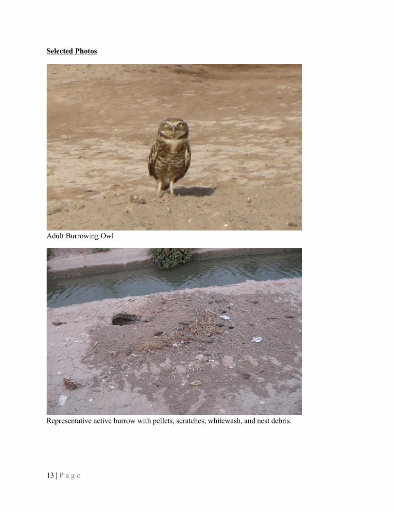
13 | P a g e
Selected Photos
Adult Burrowing Owl
Representative active burrow with pellets, scratches, whitewash, and nest debris.

14 | P a g e
Representative active burrow with prey remains (frog and crayfish), feathers, scratches, nest debris.
Representative active burrow with adult perched above and juvenile in burrow.

15 | P a g e
7.0 References California Burrowing Owl Consortium (CBOC). 1993. Burrowing Owl Survey Protocol and
Mitigation Guidelines. 15 pages.
DeSante, D.F., Burton, K.M., and O'Grady, D.R. 1996. The Monitoring Avian Productivity and Survivorship (MAPS) Program fourth and fifth annual report (1993 and 1994). Bird Populations 3:67-120.
Haug, E. A., B. A. Millsap and M. S. Martell. 1993. Burrowing Owl (Athene cunicularia), The Birds of North America Online (A. Poole, Ed.). Ithaca: Cornell Lab of Ornithology; Retrieved from the Birds of North America Online: http://bna.birds.cornell.edu.bnaproxy.birds.cornell.edu/bna/species/061doi:10.2173/bna.61
Thomsen, L. 1971. Behavior and Ecology of Burrowing Owls on the Oakland Municipal Airport. Condor 73: 177-192.
Weightman, C. 2009. Personal communication [April 17 telephone conversation with P. Golden, Heritage Environmental Consultants, Denver, Colorado. RE: CDFG requirement for pre-CEQA/NEPA surveys and pre-construction surveys]. Biologist, California Department of Fish and Game, Bermuda Dunes Field Office, Bermuda Dunes, California. 1 page.
Zam, M. 1974. Burrowing Owl. U. S. Department of Interior, Bureau of Land Management. Technical Note T-N 250. Denver, Colorado. 25pp.

16 | P a g e
Appendix A – Active and Inactive Burrow Summary Burrow
ID Project Component 2009 Breeding Season1
2009/2010 Winter1
2010 Breeding Season1
2011 Breeding Season1
1 CSE Facility Active Active N/S N/S 2 500-foot Buffer N/S N/S N/S Active 3 CSE Facility N/S N/S N/S Active 4 Gen-tie ROW N/S N/S N/S Active 5 Gen-tie 500 ft buffer N/S N/S N/S Active 6 Gen-tie 500 ft buffer N/S N/S N/S Active 7 Gen-tie 500 ft buffer N/S N/S N/S Active 8 Gen-tie 500 ft buffer N/S N/S N/S Active 9 Gen-tie 500 ft buffer N/S N/S N/S Active
10 Gen-tie ROW N/S N/S N/S Active 11 Gen-tie 500 ft buffer N/S N/S N/S Active 12 Gen-tie 500 ft buffer N/S N/S N/S Active 13 Gen-tie ROW N/S N/S N/S Active 14 Gen-tie 500 ft buffer N/S N/S N/S Active 15 Gen-tie 500 ft buffer N/S N/S N/S Active 16 500-foot Buffer N/S N/S N/S Active 17 500-foot Buffer N/S N/S N/S Active 18 CSE Facility N/S N/S N/S Active 19 500-foot Buffer N/S N/S N/S Active 20 500-foot Buffer N/S N/S N/S Active 21 500-foot Buffer Active Active N/S N/S 22 CSE Facility Active Active N/S N/S 23 CSE Facility Active Active N/S N/S 24 500-foot Buffer Active Active N/S N/S 25 500-foot Buffer Active Active N/S N/S 26 500-foot Buffer Active Active N/S N/S 27 500-foot Buffer Active Active N/S N/S 28 500-foot Buffer Active Active N/S N/S 29 500-foot Buffer Active Active N/S N/S 30 500-foot Buffer Active Inactive N/S N/S 31 500-foot Buffer Active Inactive N/S N/S 32 500-foot Buffer Active Active N/S N/S 33 500-foot Buffer Active Active N/S N/S 34 500-foot Buffer Active Inactive N/S N/S 35 500-foot Buffer Active N/S N/S N/S 36 500-foot Buffer Active N/S N/S N/S 37 500-foot Buffer Active Inactive N/S N/S 38 Gen-tie 500 ft buffer Active Inactive N/S N/S 39 Gen-tie 500 ft buffer N/S N/S N/S Inactive 40 CSE Facility N/S N/S N/S Inactive 41 CSE Facility N/S N/S N/S Inactive 42 CSE Facility N/S N/S N/S Inactive 43 CSE Facility N/S N/S N/S Inactive 44 CSE Facility N/S N/S N/S Inactive 45 CSE Facility N/S N/S N/S Inactive 46 500-foot Buffer N/S N/S N/S Inactive 47 500-foot Buffer N/S N/S N/S Inactive

17 | P a g e
Burrow ID Project Component 2009 Breeding
Season1 2009/2010 Winter1
2010 Breeding Season1
2011 Breeding Season1
48 500-foot Buffer N/S N/S N/S Inactive 49 500-foot Buffer N/S N/S N/S Inactive 50 500-foot Buffer N/S N/S N/S Inactive 51 500-foot Buffer N/S N/S N/S Inactive 52 500-foot Buffer N/S N/S N/S Inactive 53 500-foot Buffer N/S N/S N/S Inactive 54 500-foot Buffer N/S N/S N/S Inactive 55 500-foot Buffer N/S N/S N/S Inactive 56 500-foot Buffer N/S N/S N/S Inactive 57 500-foot Buffer N/S N/S N/S Inactive 58 500-foot Buffer N/S N/S N/S Inactive 59 500-foot Buffer N/S N/S N/S Inactive 60 500-foot Buffer N/S N/S N/S Inactive 61 500-foot Buffer Active Active N/S N/S 62 500-foot Buffer Active Active N/S N/S 63 500-foot Buffer N/S N/S N/S Active 64 CSE Facility N/S N/S N/S Active 65 CSE Facility N/S N/S N/S Active 66 CSE Facility N/S N/S N/S Active 67 CSE Facility Active Inactive N/S N/S 68 CSE Facility Active Active N/S N/S 69 CSE Facility Active Active N/S N/S 70 CSE Facility Active N/S N/S N/S 71 CSE Facility Active Active N/S N/S 72 CSE Facility N/S N/S N/S Inactive 73 CSE Facility N/S N/S N/S Inactive 74 CSE Facility N/S N/S N/S Inactive 75 CSE Facility N/S N/S N/S Inactive 76 CSE Facility N/S N/S N/S Inactive 77 CSE Facility N/S N/S N/S Inactive 78 CSE Facility N/S N/S N/S Inactive 79 Gen-tie 500 ft buffer N/S N/S N/S Inactive 80 Gen-tie 500 ft buffer N/S N/S N/S Inactive 81 Gen-tie ROW N/S N/S N/S Inactive 82 500-foot Buffer N/S N/S N/S Inactive 83 500-foot Buffer N/S N/S N/S Inactive 84 500-foot Buffer N/S N/S N/S Inactive 85 500-foot Buffer N/S N/S N/S Inactive 86 500-foot Buffer N/S N/S N/S Inactive 87 500-foot Buffer N/S Inactive Inactive N/S 88 500-foot Buffer N/S Inactive Inactive N/S 89 500-foot Buffer N/S Inactive Inactive N/S 90 500-foot Buffer N/S Inactive Inactive N/S 91 500-foot Buffer N/S Inactive Inactive N/S 92 500-foot Buffer N/S Inactive Inactive N/S 93 500-foot Buffer N/S Inactive Inactive N/S 94 500-foot Buffer N/S N/S Inactive N/S 95 500-foot Buffer N/S N/S Inactive N/S 96 500-foot Buffer N/S N/S N/S Active 97 500-foot Buffer N/S N/S N/S Active 98 Gen-tie 500 ft buffer N/S N/S N/S Inactive 99 Gen-tie ROW N/S N/S N/S Inactive
100 Gen-tie 500 ft buffer N/S N/S N/S Inactive 101 500-foot Buffer N/S N/S N/S Inactive

18 | P a g e
Burrow ID Project Component 2009 Breeding
Season1 2009/2010 Winter1
2010 Breeding Season1
2011 Breeding Season1
102 500-foot Buffer N/S Inactive Inactive N/S 103 500-foot Buffer N/S Inactive Inactive N/S 104 500-foot Buffer N/S Inactive Inactive N/S 105 500-foot Buffer N/S N/S N/S Inactive 106 500-foot Buffer N/S N/S N/S Inactive 107 Gen-tie ROW N/S N/S N/S Inactive 108 Gen-tie ROW N/S N/S N/S Inactive
1 N/S – Not Surveyed

Attachment 2 – Active Burrow and Owl Count Summary (2009 – 2011)
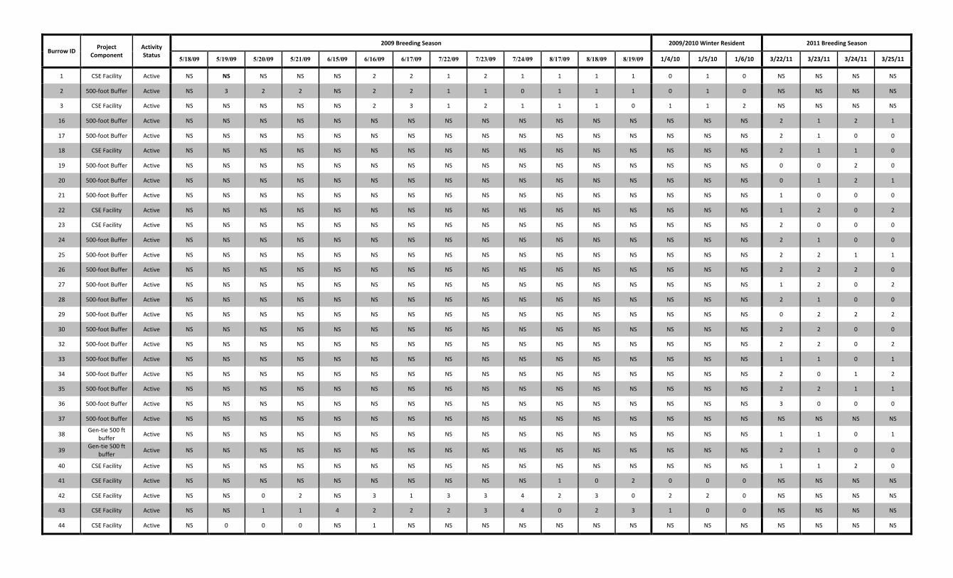
Burrow ID Project Component
Activity Status
2009 Breeding Season 2009/2010 Winter Resident 2011 Breeding Season
5/18/09 5/19/09 5/20/09 5/21/09 6/15/09 6/16/09 6/17/09 7/22/09 7/23/09 7/24/09 8/17/09 8/18/09 8/19/09 1/4/10 1/5/10 1/6/10 3/22/11 3/23/11 3/24/11 3/25/11
1 CSE Facility Active NS NS NS NS NS 2 2 1 2 1 1 1 1 0 1 0 NS NS NS NS
2 500-‐foot Buffer Active NS 3 2 2 NS 2 2 1 1 0 1 1 1 0 1 0 NS NS NS NS
3 CSE Facility Active NS NS NS NS NS 2 3 1 2 1 1 1 0 1 1 2 NS NS NS NS
16 500-‐foot Buffer Active NS NS NS NS NS NS NS NS NS NS NS NS NS NS NS NS 2 1 2 1
17 500-‐foot Buffer Active NS NS NS NS NS NS NS NS NS NS NS NS NS NS NS NS 2 1 0 0
18 CSE Facility Active NS NS NS NS NS NS NS NS NS NS NS NS NS NS NS NS 2 1 1 0
19 500-‐foot Buffer Active NS NS NS NS NS NS NS NS NS NS NS NS NS NS NS NS 0 0 2 0
20 500-‐foot Buffer Active NS NS NS NS NS NS NS NS NS NS NS NS NS NS NS NS 0 1 2 1
21 500-‐foot Buffer Active NS NS NS NS NS NS NS NS NS NS NS NS NS NS NS NS 1 0 0 0
22 CSE Facility Active NS NS NS NS NS NS NS NS NS NS NS NS NS NS NS NS 1 2 0 2
23 CSE Facility Active NS NS NS NS NS NS NS NS NS NS NS NS NS NS NS NS 2 0 0 0
24 500-‐foot Buffer Active NS NS NS NS NS NS NS NS NS NS NS NS NS NS NS NS 2 1 0 0
25 500-‐foot Buffer Active NS NS NS NS NS NS NS NS NS NS NS NS NS NS NS NS 2 2 1 1
26 500-‐foot Buffer Active NS NS NS NS NS NS NS NS NS NS NS NS NS NS NS NS 2 2 2 0
27 500-‐foot Buffer Active NS NS NS NS NS NS NS NS NS NS NS NS NS NS NS NS 1 2 0 2
28 500-‐foot Buffer Active NS NS NS NS NS NS NS NS NS NS NS NS NS NS NS NS 2 1 0 0
29 500-‐foot Buffer Active NS NS NS NS NS NS NS NS NS NS NS NS NS NS NS NS 0 2 2 2
30 500-‐foot Buffer Active NS NS NS NS NS NS NS NS NS NS NS NS NS NS NS NS 2 2 0 0
32 500-‐foot Buffer Active NS NS NS NS NS NS NS NS NS NS NS NS NS NS NS NS 2 2 0 2
33 500-‐foot Buffer Active NS NS NS NS NS NS NS NS NS NS NS NS NS NS NS NS 1 1 0 1
34 500-‐foot Buffer Active NS NS NS NS NS NS NS NS NS NS NS NS NS NS NS NS 2 0 1 2
35 500-‐foot Buffer Active NS NS NS NS NS NS NS NS NS NS NS NS NS NS NS NS 2 2 1 1
36 500-‐foot Buffer Active NS NS NS NS NS NS NS NS NS NS NS NS NS NS NS NS 3 0 0 0
37 500-‐foot Buffer Active NS NS NS NS NS NS NS NS NS NS NS NS NS NS NS NS NS NS NS NS
38 Gen-‐tie 500 ft buffer Active NS NS NS NS NS NS NS NS NS NS NS NS NS NS NS NS 1 1 0 1
39 Gen-‐tie 500 ft buffer Active NS NS NS NS NS NS NS NS NS NS NS NS NS NS NS NS 2 1 0 0
40 CSE Facility Active NS NS NS NS NS NS NS NS NS NS NS NS NS NS NS NS 1 1 2 0
41 CSE Facility Active NS NS NS NS NS NS NS NS NS NS 1 0 2 0 0 0 NS NS NS NS
42 CSE Facility Active NS NS 0 2 NS 3 1 3 3 4 2 3 0 2 2 0 NS NS NS NS
43 CSE Facility Active NS NS 1 1 4 2 2 2 3 4 0 2 3 1 0 0 NS NS NS NS
44 CSE Facility Active NS 0 0 0 NS 1 NS NS NS NS NS NS NS NS NS NS NS NS NS NS
Burrow ID Project Component
Activity Status
2009 Breeding Season 2009/2010 Winter Resident 2011 Breeding Season
5/18/09 5/19/09 5/20/09 5/21/09 6/15/09 6/16/09 6/17/09 7/22/09 7/23/09 7/24/09 8/17/09 8/18/09 8/19/09 1/4/10 1/5/10 1/6/10 3/22/11 3/23/11 3/24/11 3/25/11
45 CSE Facility Active NS NS 2 1 NS 2 1 6 6 6 3 2 4 1 1 0 NS NS NS NS
46 500-‐foot Buffer Active NS NS NS NS NS 0 2 0 1 2 2 3 1 1 0 0 NS NS NS NS
47 500-‐foot Buffer Active NS NS NS NS NS 1 3 4 4 4 4 3 3 1 1 0 NS NS NS NS
48 500-‐foot Buffer Active NS NS NS NS NS 2 3 6 6 2 3 3 3 1 1 1 NS NS NS NS
49 500-‐foot Buffer Active NS NS NS NS NS NS NS NS 6 8 3 3 4 1 1 1 NS NS NS NS
50 500-‐foot Buffer Active NS NS NS NS NS NS NS NS NS NS 4 5 3 3 3 3 NS NS NS NS
51 500-‐foot Buffer Active NS NS NS NS NS NS NS NS NS NS 4 3 4 3 2 1 NS NS NS NS
52 500-‐foot Buffer Active NS NS NS NS NS NS NS NS NS NS NS 3 2 NS 1 3 NS NS NS NS
53 500-‐foot Buffer Active NS NS NS NS NS NS NS NS NS NS NS 1 3 0 1 0 NS NS NS NS
54 500-‐foot Buffer Active NS NS NS NS NS NS NS NS NS NS NS NS 2 1 1 1 NS NS NS NS
55 500-‐foot Buffer Active NS NS NS 1 3 3 3 0 4 4 0 3 3 NS 0 0 NS NS NS NS
56 500-‐foot Buffer Active NS NS NS 2 1 1 1 0 6 5 1 2 2 NS 0 0 NS NS NS NS
57 500-‐foot Buffer Active NS NS NS NS NS NS NS NS NS NS 1 2 2 0 2 0 NS NS NS NS
58 500-‐foot Buffer Active NS NS 1 1 NS 0 0 0 NS 1 2 2 1 1 1 1 NS NS NS NS
59 500-‐foot Buffer Active NS NS NS 1 2 3 1 0 2 1 1 4 2 NS 0 0 NS NS NS NS
62 500-‐foot Buffer Active NS 1 2 2 NS 1 1 0 1 0 0 1 2 0 0 0 NS NS NS NS
63 500-‐foot Buffer Active NS 1 1 1 NS 2 2 0 3 4 0 1 0 1 0 0 NS NS NS NS

Attachment 3 – CDFG Hay Bale Shelter-‐in-‐Place Guidance and Burrow Buffer Variance Table
Hay Bales
Screening burrows (e.g. hay bale walls) has been shown as effective means of minimizing disturbance to owls. Where authorized, buffers may be reduced by implementing the use of hay bales to shelter a burrow from construction activities. Hay bales will be used for agricultural and developed locations. To minimize the potential for spreading weed seeds to native areas, only certified “weed-free” hay bales may be used on land managed by the BLM.
During the breeding season, hay bales will be stacked 3 bales high and 25 feet on either side of the burrow for a total length of 50 feet.
During the non-breeding season, bales will be stacked 2 bales high and 25 feet on either side of the burrow for a total length of 50 feet.
Hay bales are generally 3 ft long and 18” tall. A minimum of 2-3 feet will be provided between the hay bales and the occupied burrow, allowing any perches that might exist beside the burrow to be maintained. As an alternative to hay bales, fencing slats or netting may be used, provided that the slats or netting are constructed to dimensions at least equivalent to those provided above for hay bales.

Centinela Solar Energy, LLCProposed Adjustments to BUOW Buffer Distances
Proposed Avoidance Areas
Avoidance Mapbook Sheet No.
Burrow No.
Affected by
Phase I/II (a)
Non-‐Breeding Season
Avoidance Area (b)
(Typically 50 m Buffer)
Breeding Season
Avoidance Area (b),(c)
(Typically 75 m Buffer)Type of Construction Activity in Vicinity of
Burrow Location
Anticipated Duration of
Construction Activity (d)
Use Sheltering in Place During
Construction During the Breeding Season?
Justification for Sheltering in Place Determination Notes
1 59 Phase II standard 50-‐m buffer standard 75-‐m buffer N/A N/A N/A -‐ standard buffers apply
N/A -‐ standard buffers apply Burrow is located in survey buffer area northeast of CSE Facility area, construction will be restricted during the breeding season for a small portion of the southeast quadrant of the avoidance area
1 31 Phase II standard 50-‐m buffer standard 75-‐m buffer N/A N/A N/A -‐ standard buffers apply
N/A -‐ standard buffers apply Burrow is located in survey buffer area northeast of CSE Facility area, construction will be restricted during the breeding season for a small portion of the southeast quadrant of the avoidance area
1 56 Phase II standard 50-‐m buffer standard 75-‐m buffer N/A N/A N/A -‐ standard buffers apply
N/A -‐ standard buffers apply Burrow is located on opposite side of Wormwood Canal from CSE Facility; open fields to west
1 52 Phase II standard 50-‐m buffer standard 75-‐m buffer N/A N/A N/A -‐ standard buffers apply
N/A -‐ standard buffers apply Burrow is located on opposite side of Wormwood Canal from CSE Facility; open fields to west
1 55 Phase II standard 50-‐m buffer standard 75-‐m buffer N/A N/A N/A -‐ standard buffers apply
N/A -‐ standard buffers apply Burrow is located on opposite side of Wormwood Canal from CSE Facility; open fields to west
1 29 Phase II standard 50-‐m buffer standard 75-‐m buffer N/A N/A N/A -‐ standard buffers apply
N/A -‐ standard buffers apply Burrow is located on opposite side of Wormwood Canal from CSE Facility; open fields to west
2 25 Phase II standard 50-‐m buffer standard 75-‐m buffer N/A N/A N/A -‐ standard buffers apply
N/A -‐ standard buffers apply Burrow is located south of CSE Facility fenceline; open fields to the south
2 35 Phase II standard 50-‐m buffer standard 75-‐m buffer N/A N/A N/A -‐ standard buffers apply
N/A -‐ standard buffers apply Burrow is located south of CSE Facility fenceline; open fields to the south
2 34 Phase II standard 50-‐m buffer standard 75-‐m buffer N/A N/A N/A -‐ standard buffers apply
N/A -‐ standard buffers apply Burrow is located south of CSE Facility fenceline; open fields to the south
2 26 Phase II standard 50-‐m buffer standard 75-‐m buffer N/A N/A N/A -‐ standard buffers apply
N/A -‐ standard buffers apply Burrow is located south of CSE Facility fenceline; open fields to the south
2 27 Phase II standard 50-‐m buffer standard 75-‐m buffer N/A N/A N/A -‐ standard buffers apply
N/A -‐ standard buffers apply Burrow is located south of CSE Facility fenceline; open fields to the south
2 28 Phase II standard 50-‐m buffer standard 75-‐m buffer N/A N/A N/A -‐ standard buffers apply
N/A -‐ standard buffers apply Burrow is located south of CSE Facility fenceline; open fields to the south
2 24 Phase II standard 50-‐m buffer standard 75-‐m buffer N/A N/A N/A -‐ standard buffers apply
N/A -‐ standard buffers apply Burrow is located south of CSE Facility fenceline; open fields to the south
2 33 Phase II standard 50-‐m buffer standard 75-‐m buffer N/A N/A N/A -‐ standard buffers apply
N/A -‐ standard buffers apply Burrow is located adjacent to Fisher Road north of Wormwood Canal; CSE Facility features to north and south
2 32 Phase II standard 50-‐m buffer standard 75-‐m buffer N/A N/A N/A -‐ standard buffers apply
N/A -‐ standard buffers apply Burrow is located adjacent to Fisher Road north of Wormwood Canal; CSE Facility features to north and south
3 23 Phase Ia standard 50-‐m buffer in W half; 34-‐m buffer in E half (to CSE Facility fenceline)
standard 75-‐m buffer in W half; 34-‐m buffer in E half (to CSE Facility fenceline)
a) Site preparation/fencingb) Roadsc) Pier installationd) Aboveground equipment: PV modules, tracker hardware, electrical
a) 1 weekb) 1 weekc) 1 weekd) 1 week each
Yes (to east but not west)
Phase II is located to west, so sheltering not necessary in that direction
Burrow is located adjacent to Mount Signal Drain; CSE Facility project features to east and west; area to west is part of Phase II
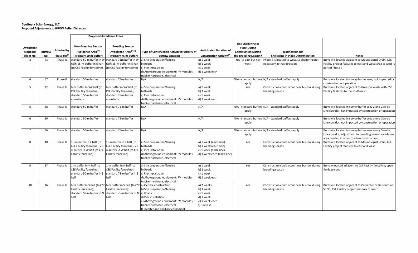
Centinela Solar Energy, LLCProposed Adjustments to BUOW Buffer Distances
Proposed Avoidance Areas
Avoidance Mapbook Sheet No.
Burrow No.
Affected by
Phase I/II (a)
Non-‐Breeding Season
Avoidance Area (b)
(Typically 50 m Buffer)
Breeding Season
Avoidance Area (b),(c)
(Typically 75 m Buffer)Type of Construction Activity in Vicinity of
Burrow Location
Anticipated Duration of
Construction Activity (d)
Use Sheltering in Place During
Construction During the Breeding Season?
Justification for Sheltering in Place Determination Notes
3 43 Phase Ia standard 50-‐m buffer in W half; 15-‐m buffer in E half (to CSE Facility fenceline)
standard 75m buffer in W half; 15-‐m buffer in E half (to CSE Facility fenceline)
a) Site preparation/fencingb) Roadsc) Pier installationd) Aboveground equipment: PV modules, tracker hardware, electrical
a) 1 weekb) 1 weekc) 1 weekd) 1 week each
Yes (to east but not west)
Phase II is located to west, so sheltering not necessary in that direction
Burrow is located adjacent to Mount Signal Drain; CSE Facility project features to east and west; area to west is part of Phase II
4 57 Phase II standard 50-‐m buffer standard 75-‐m buffer N/A N/A N/A -‐ standard buffers apply
N/A -‐ standard buffers apply Burrow is located in survey buffer area, not impacted by construction or operation
5 22 Phase Ia 6-‐m buffer in SW half (to CSE Facility fenceline); standard 50-‐m buffer elsewhere
6-‐m buffer in SW half (to CSE Facility fenceline); standard 75-‐m buffer elsewhere
a) Site preparation/fencingb) Roadsc) Pier installationd) Aboveground equipment: PV modules, tracker hardware, electrical
a) 1 weekb) 1 weekc) 1 weekd) 1 week each
Yes Construction could occur near burrow during breeding season
Burrow is located adjacent to Greeson Wash, with CSE Facility features to the southwest
6 38 Phase Ia standard 50-‐m buffer standard 75-‐m buffer N/A N/A N/A -‐ standard buffers apply
N/A -‐ standard buffers apply Burrow is located in survey buffer area along Gen-‐tie Line corridor, not impacted by construction or operation
6 39 Phase Ia standard 50-‐m buffer standard 75-‐m buffer N/A N/A N/A -‐ standard buffers apply
N/A -‐ standard buffers apply Burrow is located in survey buffer area along Gen-‐tie Line corridor, not impacted by construction or operation
7 36 Phase Ia standard 50-‐m buffer standard 75-‐m buffer N/A N/A N/A -‐ standard buffers apply
N/A -‐ standard buffers apply Burrow is located in survey buffer area along Gen-‐tie Line corridor, adjustment to breeding season avoidance area needed in order to allow construction
8 40 Phase Ia 16-‐m buffer in E half (to CSE Facility fenceline); 28-‐m buffer in W half (to CSE Facility fenceline)
16-‐m buffer in E half (to CSE Facility fenceline); 28-‐m buffer in W half (to CSE Facility fenceline)
a) Site preparation/fencingb) Roadsc) Pier installationd) Aboveground equipment: PV modules, tracker hardware, electrical
a) 1 week (each side)b) 1 week (each side)c) 1 week (each side)d) 1 week each (each side)
Yes Construction could occur near burrow during breeding season
Burrow is located adjacent to Mount Signal Drain; CSE Facility project features to east and west
9 37 Phase Ia 1-‐m buffer in N half (to CSE Facility fenceline); standard 50-‐m buffer in S half
1-‐m buffer in N half (to CSE Facility fenceline); standard 75-‐m buffer in S half
a) Site preparation/fencingb) Roadsc) Pier installationd) Aboveground equipment: PV modules, tracker hardware, electrical
a) 1 weekb) 1 weekc) 1 weekd) 1 week each
Yes Construction could occur near burrow during breeding season
Burrow located adjacent to CSE Facility fenceline; open fields to south
10 16 Phase Ia 6-‐m buffer in S half (to CSE Facility fenceline); standard 50-‐m buffer in N half
6-‐m buffer in S half (to CSE Facility fenceline); standard 75-‐m buffer in N half
a) Gen-‐tie constructionb) Site preparation/fencingc) Roadsd) Pier installatione) Aboveground equipment: PV modules, tracker hardware, electrical f) Inverter and ancillary equipment
a) 2 weeksb) 1 weekc) 1 weekd) 1 weeke) 1 week eachf) 3 weeks
Yes Construction could occur near burrow during breeding season
Burrow is located adjacent to Carpenter Drain south of SR 98; CSE Facility project features to south
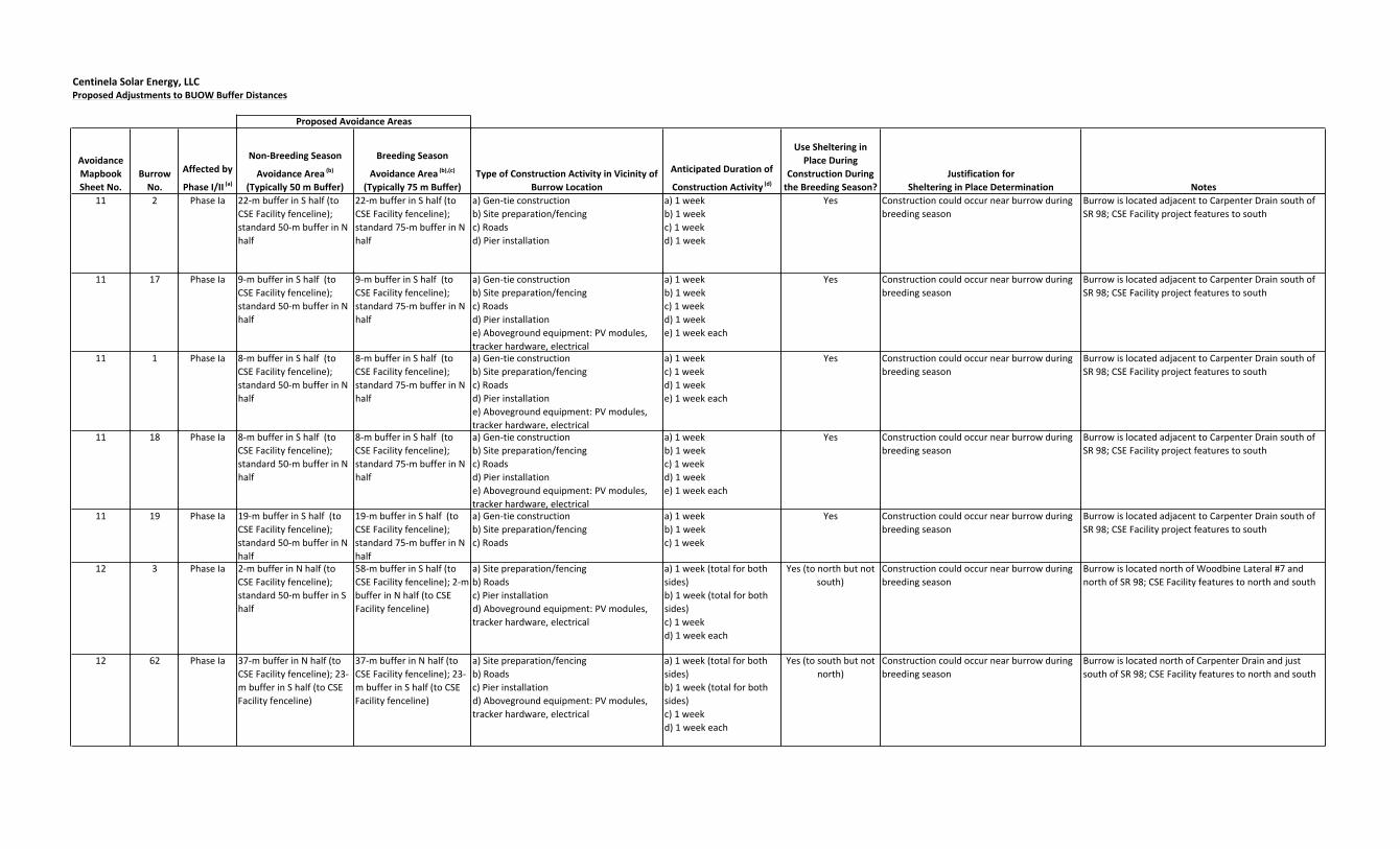
Centinela Solar Energy, LLCProposed Adjustments to BUOW Buffer Distances
Proposed Avoidance Areas
Avoidance Mapbook Sheet No.
Burrow No.
Affected by
Phase I/II (a)
Non-‐Breeding Season
Avoidance Area (b)
(Typically 50 m Buffer)
Breeding Season
Avoidance Area (b),(c)
(Typically 75 m Buffer)Type of Construction Activity in Vicinity of
Burrow Location
Anticipated Duration of
Construction Activity (d)
Use Sheltering in Place During
Construction During the Breeding Season?
Justification for Sheltering in Place Determination Notes
11 2 Phase Ia 22-‐m buffer in S half (to CSE Facility fenceline); standard 50-‐m buffer in N half
22-‐m buffer in S half (to CSE Facility fenceline); standard 75-‐m buffer in N half
a) Gen-‐tie constructionb) Site preparation/fencingc) Roadsd) Pier installation
a) 1 weekb) 1 weekc) 1 weekd) 1 week
Yes Construction could occur near burrow during breeding season
Burrow is located adjacent to Carpenter Drain south of SR 98; CSE Facility project features to south
11 17 Phase Ia 9-‐m buffer in S half (to CSE Facility fenceline); standard 50-‐m buffer in N half
9-‐m buffer in S half (to CSE Facility fenceline); standard 75-‐m buffer in N half
a) Gen-‐tie constructionb) Site preparation/fencingc) Roadsd) Pier installatione) Aboveground equipment: PV modules, tracker hardware, electrical
a) 1 weekb) 1 weekc) 1 weekd) 1 weeke) 1 week each
Yes Construction could occur near burrow during breeding season
Burrow is located adjacent to Carpenter Drain south of SR 98; CSE Facility project features to south
11 1 Phase Ia 8-‐m buffer in S half (to CSE Facility fenceline); standard 50-‐m buffer in N half
8-‐m buffer in S half (to CSE Facility fenceline); standard 75-‐m buffer in N half
a) Gen-‐tie constructionb) Site preparation/fencingc) Roadsd) Pier installatione) Aboveground equipment: PV modules, tracker hardware, electrical
a) 1 weekc) 1 weekd) 1 weeke) 1 week each
Yes Construction could occur near burrow during breeding season
Burrow is located adjacent to Carpenter Drain south of SR 98; CSE Facility project features to south
11 18 Phase Ia 8-‐m buffer in S half (to CSE Facility fenceline); standard 50-‐m buffer in N half
8-‐m buffer in S half (to CSE Facility fenceline); standard 75-‐m buffer in N half
a) Gen-‐tie constructionb) Site preparation/fencingc) Roadsd) Pier installatione) Aboveground equipment: PV modules, tracker hardware, electrical
a) 1 weekb) 1 weekc) 1 weekd) 1 weeke) 1 week each
Yes Construction could occur near burrow during breeding season
Burrow is located adjacent to Carpenter Drain south of SR 98; CSE Facility project features to south
11 19 Phase Ia 19-‐m buffer in S half (to CSE Facility fenceline); standard 50-‐m buffer in N half
19-‐m buffer in S half (to CSE Facility fenceline); standard 75-‐m buffer in N half
a) Gen-‐tie constructionb) Site preparation/fencingc) Roads
a) 1 weekb) 1 weekc) 1 week
Yes Construction could occur near burrow during breeding season
Burrow is located adjacent to Carpenter Drain south of SR 98; CSE Facility project features to south
12 3 Phase Ia 2-‐m buffer in N half (to CSE Facility fenceline); standard 50-‐m buffer in S half
58-‐m buffer in S half (to CSE Facility fenceline); 2-‐m buffer in N half (to CSE Facility fenceline)
a) Site preparation/fencingb) Roadsc) Pier installationd) Aboveground equipment: PV modules, tracker hardware, electrical
a) 1 week (total for both sides)b) 1 week (total for both sides)c) 1 week d) 1 week each
Yes (to north but not south)
Construction could occur near burrow during breeding season
Burrow is located north of Woodbine Lateral #7 and north of SR 98; CSE Facility features to north and south
12 62 Phase Ia 37-‐m buffer in N half (to CSE Facility fenceline); 23-‐m buffer in S half (to CSE Facility fenceline)
37-‐m buffer in N half (to CSE Facility fenceline); 23-‐m buffer in S half (to CSE Facility fenceline)
a) Site preparation/fencingb) Roadsc) Pier installationd) Aboveground equipment: PV modules, tracker hardware, electrical
a) 1 week (total for both sides)b) 1 week (total for both sides)c) 1 week d) 1 week each
Yes (to south but not north)
Construction could occur near burrow during breeding season
Burrow is located north of Carpenter Drain and just south of SR 98; CSE Facility features to north and south

Centinela Solar Energy, LLCProposed Adjustments to BUOW Buffer Distances
Proposed Avoidance Areas
Avoidance Mapbook Sheet No.
Burrow No.
Affected by
Phase I/II (a)
Non-‐Breeding Season
Avoidance Area (b)
(Typically 50 m Buffer)
Breeding Season
Avoidance Area (b),(c)
(Typically 75 m Buffer)Type of Construction Activity in Vicinity of
Burrow Location
Anticipated Duration of
Construction Activity (d)
Use Sheltering in Place During
Construction During the Breeding Season?
Justification for Sheltering in Place Determination Notes
13 54 Phase Ia 7-‐m buffer in N half (to CSE Facility fenceline); standard 50-‐m buffer in S half
53-‐m buffer in S half (to CSE Facility fenceline); 7-‐m buffer in N half (to CSE Facility fenceline)
a) Collector substation constructionb) 34.5-‐kV overhead linec) Site preparation/fencingd) Roadse) Pier installationf) Aboveground equipment: PV modules, tracker hardware, electrical
a) 3 weeks b) 1 week c) 1 week (total for both sides)d) 1 week e) 1 week f) 1 week each
Yes (to north but not south)
Construction could occur near burrow during breeding season
Burrow is located north of Woodbine Lateral #7 and north of SR 98; CSE Facility features to north and south
13 50 Phase Ia 7-‐m buffer in N half (to CSE Facility fenceline); standard 50-‐m buffer in S half
53-‐m buffer in S half (to CSE Facility fenceline); 7-‐m buffer in N half (to CSE Facility fenceline)
a) 34.5-‐kV overhead lineb) Site preparation/fencingc) Roadsd) Pier installatione) Aboveground equipment: PV modules, tracker hardware, electrical
a) 1 week b) 1 week (total for both sides)c) 1 week (total for both sides)d) 1 week e) 1 week each
Yes (to north but not south)
Construction could occur near burrow during breeding season
Burrow is located north of Woodbine Lateral #7 and north of SR 98; CSE Facility features to north and south
13 63 Phase Ib 8-‐m buffer in N half (to CSE Facility fenceline); standard 50-‐m buffer in S half
53-‐m buffer in S half (to CSE Facility fenceline); 8-‐m buffer in N half
a) Site preparation/fencingb) Roadsc) Pier installationd) Aboveground equipment: PV modules, tracker hardware, electrical
a) 1 week (total for both sides)b) 1 week (total for both sides)c) 1 week d) 1 week each
Yes (to north but not south)
Construction could occur near burrow during breeding season
Burrow is located north of Woodbine Lateral #7 and north of SR 98; CSE Facility features to north and south
13 46 Phase Ib 8-‐m buffer in N half (to CSE Facility fenceline); standard 50-‐m buffer in S half
52-‐m buffer in S half (to CSE Facility fenceline); 8-‐m buffer in N half (to CSE Facility fenceline)
a) Stormwater basinb) Site preparation/fencingc) Roadsd) Pier installatione) Aboveground equipment: PV modules, tracker hardware, electrical
a) 2 weeksb) 1 week (total for both sides)c) 1 week (total for both sides)d) 1 week e) 1 week each
Yes (to north but not south)
Construction could occur near burrow during breeding season
Burrow is located north of Woodbine Lateral #7 and north of SR 98; CSE Facility features to north and south
13 45 Phase Ib 1-‐m buffer in N half (to CSE Facility fenceline); standard 50-‐m buffer in S half
60-‐m buffer in S half (to CSE Facility fenceline); 1-‐m buffer in N half (to CSE Facility fenceline)
a) Site preparation/fencingb) Roadsc) Pier installationd) Aboveground equipment: PV modules, tracker hardware, electrical e) Construction parking & staging area
a) 1 week (total for both sides)b) 1 week (total for both sides)c) 1 week d) 1 week eache) Year-‐round during construction
Yes (to north but not south)
Construction could occur near burrow during breeding season
Burrow is located north of Woodbine Lateral #7 and north of SR 98; CSE Facility features to north and south

Centinela Solar Energy, LLCProposed Adjustments to BUOW Buffer Distances
Proposed Avoidance Areas
Avoidance Mapbook Sheet No.
Burrow No.
Affected by
Phase I/II (a)
Non-‐Breeding Season
Avoidance Area (b)
(Typically 50 m Buffer)
Breeding Season
Avoidance Area (b),(c)
(Typically 75 m Buffer)Type of Construction Activity in Vicinity of
Burrow Location
Anticipated Duration of
Construction Activity (d)
Use Sheltering in Place During
Construction During the Breeding Season?
Justification for Sheltering in Place Determination Notes
14 51 Phase Ia 37-‐m buffer in W half (to CSE Facility fenceline); standard 50-‐m buffer in E half
37-‐m buffer in W half (to CSE Facility fenceline); standard 75-‐m buffer in E half
a) Site preparation/fencingb) Roadsc) Pier installationd) Inverter and ancillary equipmente) Aboveground equipment: PV modules, tracker hardware, electrical
a) 1 weekb) 1 weekc) 1 weekd) 3 weekse) 1 week each
No Burrow is separated from CSE Facility by Wells Drain and Brockman Road; construction to W of burrow not planned during breeding season
Burrow is located east of Wells Drain and Brockman Road; CSE Facility features to west
14 47 Phase Ia 41-‐m buffer in W half (to CSE Facility fenceline); standard 50-‐m buffer in E half
41-‐m buffer in W half (to CSE Facility fenceline); standard 75-‐m buffer in E half
a) Site preparation/fencingb) Roadsc) Pier installationd) Aboveground equipment: PV modules, tracker hardware, electrical
a) 1 weekb) 1 weekc) 1 weekd) 1 week each
No Burrow is separated from CSE Facility by Wells Drain and Brockman Road; construction to W of burrow not planned during breeding season
Burrow is located east of Wells Drain and Brockman Road; CSE Facility features to west
14 53 Phase Ia 39-‐m buffer in W half (to CSE Facility fenceline); standard 50-‐m buffer in E half
39-‐m buffer in W half (to CSE Facility fenceline); standard 75-‐m buffer in E half
a) Site preparation/fencingb) Roadsc) Pier installationd) Inverter and ancillary equipmente) Aboveground equipment: PV modules, tracker hardware, electrical
a) 1 weekb) 1 weekc) 1 weekd) 3 weekse) 1 week each
No Burrow is separated from CSE Facility by Wells Drain and Brockman Road; construction to W of burrow not planned during breeding season
Burrow is located east of Wells Drain and Brockman Road; CSE Facility features to west
14 48 Phase Ia 39-‐m buffer in W half (to CSE Facility fenceline); standard 50-‐m buffer in E half
39-‐m buffer in W half (to CSE Facility fenceline); standard 75-‐m buffer in E half
a) Site preparation/fencingb) Roadsc) Pier installationd) Inverter and ancillary equipmente) Aboveground equipment: PV modules, tracker hardware, electrical
a) 1 weekb) 1 weekc) 1 weekd) 3 weekse) 1 week each
No Burrow is separated from CSE Facility by Wells Drain and Brockman Road; construction to W of burrow not planned during breeding season
Burrow is located east of Wells Drain and Brockman Road; CSE Facility features to west
14 49 Phase Ia 36-‐m buffer in W half (to CSE Facility fenceline); standard 50-‐m buffer in E half
36-‐m buffer in W half (to CSE Facility fenceline); standard 75-‐m buffer in E half
a) Site preparation/fencingb) Roadsc) Pier installationd) Aboveground equipment: PV modules, tracker hardware, electrical
a) 1 weekb) 1 weekc) 1 weekd) 1 week each
No Burrow is separated from CSE Facility by Wells Drain and Brockman Road; construction to W of burrow not planned during breeding season
Burrow is located east of Wells Drain and Brockman Road; CSE Facility features to west
15 41 Phase Ia 45-‐m buffer in W half (to CSE Facility fenceline); standard 50-‐m buffer to E half
45-‐m buffer in W half (to CSE Facility fenceline); standard 75-‐m buffer in E half
a) Site preparation/fencingb) Roadsc) Pier installationd) Aboveground equipment: PV modules, tracker hardware, electrical
a) 1 weekb) 1 weekc) <1 weekd) <1 week each
No Burrow is separated from CSE Facility Phase I by Wells Drain, Brockman Road, and Woodbine Canal
Burrow is located between Wells Drain and Brockman Road; CSE Facility features to east and west; Phase II is to the east of this location
15 44 Phase Ia 46-‐m buffer in W half (to CSE Facility fenceline); standard 50-‐m buffer to E half
46-‐m buffer in W half (to CSE Facility fenceline); standard 75-‐m buffer in E half
a) Site preparation/fencingb) Roadsc) Pier installationd) Inverter and ancillary equipmente) Aboveground equipment: PV modules, tracker hardware, electrical
a) 1 weekb) <1 weekc) 1 weekd) 3 weekse) <1 week each
No Burrow is separated from CSE Facility Phase I by Wells Drain, Brockman Road, and Woodbine Canal
Burrow is located between Wells Drain and Brockman Road; CSE Facility features to east and west; Phase II is to the east of this location
16 42 Phase II standard 50-‐m buffer standard 75-‐m buffer N/A N/A N/A -‐ standard buffers apply
N/A -‐ standard buffers apply Burrow is located adjacent to Woodbine Canal and north of SR 98; CSE Facility features to north
17 58 Phase II standard 50-‐m buffer standard 75-‐m buffer N/A N/A N/A -‐ standard buffers apply
N/A -‐ standard buffers apply Burrow is located in survey buffer area north of CSE Facility area, not impacted by construction or operation

Centinela Solar Energy, LLCProposed Adjustments to BUOW Buffer Distances
Proposed Avoidance Areas
Avoidance Mapbook Sheet No.
Burrow No.
Affected by
Phase I/II (a)
Non-‐Breeding Season
Avoidance Area (b)
(Typically 50 m Buffer)
Breeding Season
Avoidance Area (b),(c)
(Typically 75 m Buffer)Type of Construction Activity in Vicinity of
Burrow Location
Anticipated Duration of
Construction Activity (d)
Use Sheltering in Place During
Construction During the Breeding Season?
Justification for Sheltering in Place Determination Notes
18 21 Phase II standard 50-‐m buffer standard 75-‐m buffer N/A N/A N/A -‐ standard buffers apply
N/A -‐ standard buffers apply Burrow is located in survey buffer area southeast of CSE Facility area, not impacted by construction or operation
18 70 Phase II standard 50-‐m buffer standard 75-‐m buffer N/A N/A N/A -‐ standard buffers apply
N/A -‐ standard buffers apply Burrow is located in survey buffer area southeast of CSE Facility area, not impacted by construction or operation
Notes:
(c) Construction traffic may travel on CSE Facility roads within the project fenceline during breeding season within breeding season buffers; however, traffic shall not stop or conduct work within breeding season avoidance areas except where such avoidance areas are adjusted to accommodate construction work. Site preparation (e.g., grading) is expected to occur from May 2012 through January 2013; therefore, a substantial portion of the grading may occur outside of the breeding season.(d) Anticipated cumulative duration for each type of construction activity within the 75-‐meter breeding season buffer. Work on each task may be conducted intermittently throughout multiple weeks or months.
(b) Reductions to buffers would allow permanent facility infrastructure and roads to be located within 50 and 75 meters of owl burrows.(a) Construction phasing designations shown here are preliminary; CSE will submit updated phasing information if necessary upon completion of final engineering.

Attachment 4 – Mitigation Mapbook

CSE FACILITYAPN 052-430-009
59
56
55
52
31
29
Worm
wood
Can
alWO
RMWO
OD R
D
0 100 200 300 400 500
Feet
Legend
Existing Road
Active Burrow within CSE Facility 500-Foot Buffer
CSE Facility 500-Foot Buffer
12-20-11
CSE Project Component
1Page:
Alternative 3 Gen-tie Line Route
Alternative 3 Gen-tie Line Structure
Fenceline
Centinela Solar Energy, LLCAttachment 3
Burrowing OwlActive Burrows
°
State Plane Coordinate SystemCalifornia Zone 6
Feet
Merged Active Burrow Buffers for Habitat Calculations
2
13
1
4
1411 15
3 5
96 7 8
1217
1610 18
OP29OP30

CSE FACILITYAPN 052-170-019
CSE FACILITYAPN 052-170-019
CSE FACILITYAPN 052-170-074
CSE FACILITYAPN 052-170-019
35 34 33 322827262524Wormwood Canal
Worm
wood
Can
al
FISHER RD
WORM
WOOD
RD
0 100 200 300 400 500
Feet
Legend
Existing Road
Active Burrow within CSE Facility 500-Foot Buffer
CSE Facility 500-Foot Buffer
12-20-11
CSE Project Component
2Page:
Alternative 3 Gen-tie Line Route
Alternative 3 Gen-tie Line Structure
Fenceline
Centinela Solar Energy, LLCAttachment 3
Burrowing OwlActive Burrows
°
State Plane Coordinate SystemCalifornia Zone 6
Feet
Merged Active Burrow Buffers for Habitat Calculations
2
13
1
4
1411 15
3 5
96 7 8
1217
1610 18
OP29OP30

CSE FACILITYAPN 052-170-019
CSE FACILITYAPN 052-170-018
4323
Moun
t Sign
al Dr
ain
0 100 200 300
Feet
Legend
Existing Road
Active Burrow within CSE Facility 500-Foot Buffer
CSE Facility 500-Foot Buffer
12-20-11
CSE Project Component
3Page:
Alternative 3 Gen-tie Line Route
Alternative 3 Gen-tie Line Structure
Fenceline
Centinela Solar Energy, LLCAttachment 3
Burrowing OwlActive Burrows
°
State Plane Coordinate SystemCalifornia Zone 6
Feet
Merged Active Burrow Buffers for Habitat Calculations
2
13
1
4
1411 15
3 5
96 7 8
1217
1610 18
OP29OP30
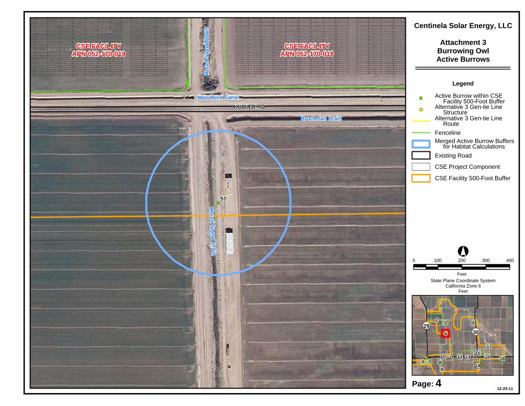
CSE FACILITYAPN 052-170-018
CSE FACILITYAPN 052-170-019
57
Woodbine Canal
Mount Signal Drain
Brockman Drain
Moun
t Sign
al Dr
ain
KUBLER RD
0 100 200 300 400
Feet
Legend
Existing Road
Active Burrow within CSE Facility 500-Foot Buffer
CSE Facility 500-Foot Buffer
12-20-11
CSE Project Component
4Page:
Alternative 3 Gen-tie Line Route
Alternative 3 Gen-tie Line Structure
Fenceline
Centinela Solar Energy, LLCAttachment 3
Burrowing OwlActive Burrows
°
State Plane Coordinate SystemCalifornia Zone 6
Feet
Merged Active Burrow Buffers for Habitat Calculations
2
13
1
4
1411 15
3 5
96 7 8
1217
1610 18
OP29OP30

CSE FACILITYAPN 052-170-068
22
Greeson Wash
BROCKMAN RD
COUNTY HWY S30
OP30
0 100 200 300
Feet
Legend
Existing Road
Active Burrow within CSE Facility 500-Foot Buffer
CSE Facility 500-Foot Buffer
12-20-11
CSE Project Component
5Page:
Alternative 3 Gen-tie Line Route
Alternative 3 Gen-tie Line Structure
Fenceline
Centinela Solar Energy, LLCAttachment 3
Burrowing OwlActive Burrows
°
State Plane Coordinate SystemCalifornia Zone 6
Feet
Merged Active Burrow Buffers for Habitat Calculations
2
13
1
4
1411 15
3 5
96 7 8
1217
1610 18
OP29OP30
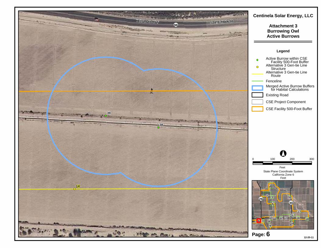
39
38
14
YUHA CUTOFF STATE HWY 98 OP98
0 100 200 300
Feet
Legend
Existing Road
Active Burrow within CSE Facility 500-Foot Buffer
CSE Facility 500-Foot Buffer
12-20-11
CSE Project Component
6Page:
Alternative 3 Gen-tie Line Route
Alternative 3 Gen-tie Line Structure
Fenceline
Centinela Solar Energy, LLCAttachment 3
Burrowing OwlActive Burrows
°
State Plane Coordinate SystemCalifornia Zone 6
Feet
Merged Active Burrow Buffers for Habitat Calculations
2
13
1
4
1411 15
3 5
96 7 8
1217
1610 18
OP29OP30
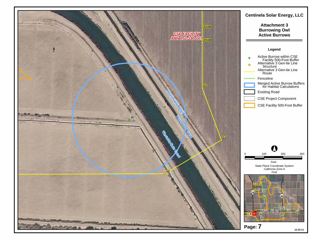
CSE FACILITYAPN 052-190-007
36
12
11
10
DSW
DSW
Wormwood Canal
Westside Main Canal
Mount Signal Drain 1
0 100 200 300
Feet
Legend
Existing Road
Active Burrow within CSE Facility 500-Foot Buffer
CSE Facility 500-Foot Buffer
12-20-11
CSE Project Component
7Page:
Alternative 3 Gen-tie Line Route
Alternative 3 Gen-tie Line Structure
Fenceline
Centinela Solar Energy, LLCAttachment 3
Burrowing OwlActive Burrows
°
State Plane Coordinate SystemCalifornia Zone 6
Feet
Merged Active Burrow Buffers for Habitat Calculations
2
13
1
4
1411 15
3 5
96 7 8
1217
1610 18
OP29OP30

CSE FACILITYAPN 052-190-007
CSE FACILITYAPN 052-190-008
40Mo
unt S
ignal
Drain
0 100 200 300
Feet
Legend
Existing Road
Active Burrow within CSE Facility 500-Foot Buffer
CSE Facility 500-Foot Buffer
12-20-11
CSE Project Component
8Page:
Alternative 3 Gen-tie Line Route
Alternative 3 Gen-tie Line Structure
Fenceline
Centinela Solar Energy, LLCAttachment 3
Burrowing OwlActive Burrows
°
State Plane Coordinate SystemCalifornia Zone 6
Feet
Merged Active Burrow Buffers for Habitat Calculations
2
13
1
4
1411 15
3 5
96 7 8
1217
1610 18
OP29OP30

CSE FACILITYAPN 052-190-008
CSE FACILITYAPN 052-190-007
37
Moun
t Sign
al Dr
ain
0 100 200 300
Feet
Legend
Existing Road
Active Burrow within CSE Facility 500-Foot Buffer
CSE Facility 500-Foot Buffer
12-20-11
CSE Project Component
9Page:
Alternative 3 Gen-tie Line Route
Alternative 3 Gen-tie Line Structure
Fenceline
Centinela Solar Energy, LLCAttachment 3
Burrowing OwlActive Burrows
°
State Plane Coordinate SystemCalifornia Zone 6
Feet
Merged Active Burrow Buffers for Habitat Calculations
2
13
1
4
1411 15
3 5
96 7 8
1217
1610 18
OP29OP30

CSE FACILITYAPN 052-190-008
16
6
Carpenter Drain
YUHA CUTOFF STATE HWY 98 OP98
0 100 200 300
Feet
Legend
Existing Road
Active Burrow within CSE Facility 500-Foot Buffer
CSE Facility 500-Foot Buffer
12-20-11
CSE Project Component
10Page:
Alternative 3 Gen-tie Line Route
Alternative 3 Gen-tie Line Structure
Fenceline
Centinela Solar Energy, LLCAttachment 3
Burrowing OwlActive Burrows
°
State Plane Coordinate SystemCalifornia Zone 6
Feet
Merged Active Burrow Buffers for Habitat Calculations
2
13
1
4
1411 15
3 5
96 7 8
1217
1610 18
OP29OP30

CSE FACILITYAPN 052-190-008
21
19
1817
5 4
Carpenter Drain
Wood
bine L
ateral
7
STATE HWY 98 YUHA CUTOFF
PULL
IAM
RD
OP98
0 100 200 300 400
Feet
Legend
Existing Road
Active Burrow within CSE Facility 500-Foot Buffer
CSE Facility 500-Foot Buffer
12-20-11
CSE Project Component
11Page:
Alternative 3 Gen-tie Line Route
Alternative 3 Gen-tie Line Structure
Fenceline
Centinela Solar Energy, LLCAttachment 3
Burrowing OwlActive Burrows
°
State Plane Coordinate SystemCalifornia Zone 6
Feet
Merged Active Burrow Buffers for Habitat Calculations
2
13
1
4
1411 15
3 5
96 7 8
1217
1610 18
OP29OP30

CSE FACILITYAPN 052-190-009
CSE FACILITYAPN 052-170-036
3
62
2
Carpenter Drain
Woodbine Lateral 7
STATE HWY 98 OP98
0 100 200 300
Feet
Legend
Existing Road
Active Burrow within CSE Facility 500-Foot Buffer
CSE Facility 500-Foot Buffer
12-20-11
CSE Project Component
12Page:
Alternative 3 Gen-tie Line Route
Alternative 3 Gen-tie Line Structure
Fenceline
Centinela Solar Energy, LLCAttachment 3
Burrowing OwlActive Burrows
°
State Plane Coordinate SystemCalifornia Zone 6
Feet
Merged Active Burrow Buffers for Habitat Calculations
2
13
1
4
1411 15
3 5
96 7 8
1217
1610 18
OP29OP30
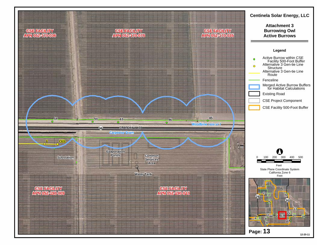
EvaporationPondsSubstation Common
ServicesArea
Water Tank
CSE FACILITYAPN 052-190-010
CSE FACILITYAPN 052-190-009
CSE FACILITYAPN 052-170-078
CSE FACILITYAPN 052-170-036
CSE FACILITYAPN 052-170-035
CSE FACILITYAPN 052-170-035
6354 50 46 45
1 CFS
Carpenter Drain
Woodbine Lateral 7STATE HWY 98 OP98
0 100 200 300 400 500
Feet
Legend
Existing Road
Active Burrow within CSE Facility 500-Foot Buffer
CSE Facility 500-Foot Buffer
12-20-11
CSE Project Component
13Page:
Alternative 3 Gen-tie Line Route
Alternative 3 Gen-tie Line Structure
Fenceline
Centinela Solar Energy, LLCAttachment 3
Burrowing OwlActive Burrows
°
State Plane Coordinate SystemCalifornia Zone 6
Feet
Merged Active Burrow Buffers for Habitat Calculations
2
13
1
4
1411 15
3 5
96 7 8
1217
1610 18
OP29OP30

CSE FACILITYAPN 052-190-010
53
51
49
48
47We
lls D
rain
BROC
KMAN
RD
0 100 200 300 400 500
Feet
Legend
Existing Road
Active Burrow within CSE Facility 500-Foot Buffer
CSE Facility 500-Foot Buffer
12-20-11
CSE Project Component
14Page:
Alternative 3 Gen-tie Line Route
Alternative 3 Gen-tie Line Structure
Fenceline
Centinela Solar Energy, LLCAttachment 3
Burrowing OwlActive Burrows
°
State Plane Coordinate SystemCalifornia Zone 6
Feet
Merged Active Burrow Buffers for Habitat Calculations
2
13
1
4
1411 15
3 5
96 7 8
1217
1610 18
OP29OP30

CSE FACILITYAPN 052-180-033
CSE FACILITYAPN 052-170-035
44
41
Wells
Drai
n
Wood
bine C
anal
BROC
KMAN
RD
COUN
TY H
WY S3
0
OP30
0 100 200 300 400
Feet
Legend
Existing Road
Active Burrow within CSE Facility 500-Foot Buffer
CSE Facility 500-Foot Buffer
12-20-11
CSE Project Component
15Page:
Alternative 3 Gen-tie Line Route
Alternative 3 Gen-tie Line Structure
Fenceline
Centinela Solar Energy, LLCAttachment 3
Burrowing OwlActive Burrows
°
State Plane Coordinate SystemCalifornia Zone 6
Feet
Merged Active Burrow Buffers for Habitat Calculations
2
13
1
4
1411 15
3 5
96 7 8
1217
1610 18
OP29OP30

CSE FACILITYAPN 052-180-033
42Woodbine Canal
Woodbine Lateral 2
STATE HWY 98 OP98
0 100 200 300
Feet
Legend
Existing Road
Active Burrow within CSE Facility 500-Foot Buffer
CSE Facility 500-Foot Buffer
12-20-11
CSE Project Component
16Page:
Alternative 3 Gen-tie Line Route
Alternative 3 Gen-tie Line Structure
Fenceline
Centinela Solar Energy, LLCAttachment 3
Burrowing OwlActive Burrows
°
State Plane Coordinate SystemCalifornia Zone 6
Feet
Merged Active Burrow Buffers for Habitat Calculations
2
13
1
4
1411 15
3 5
96 7 8
1217
1610 18
OP29OP30

CSE FACILITYAPN 052-180-033
CSE FACILITYAPN 052-180-032
58
Wells DrainWoodbine Lateral 2
Wells Drain
0 100 200 300
Feet
Legend
Existing Road
Active Burrow within CSE Facility 500-Foot Buffer
CSE Facility 500-Foot Buffer
12-20-11
CSE Project Component
17Page:
Alternative 3 Gen-tie Line Route
Alternative 3 Gen-tie Line Structure
Fenceline
Centinela Solar Energy, LLCAttachment 3
Burrowing OwlActive Burrows
°
State Plane Coordinate SystemCalifornia Zone 6
Feet
Merged Active Burrow Buffers for Habitat Calculations
2
13
1
4
1411 15
3 5
96 7 8
1217
1610 18
OP29OP30

Water Tank
CSE FACILITYAPN 052-180-032
21
20
Woodbine Canal
Gree
son D
rain 2
STATE HWY 98
ROCK
WOOD
RD
ROCK
WOOD
RD
OP98
0 100 200 300
Feet
Legend
Existing Road
Active Burrow within CSE Facility 500-Foot Buffer
CSE Facility 500-Foot Buffer
12-20-11
CSE Project Component
18Page:
Alternative 3 Gen-tie Line Route
Alternative 3 Gen-tie Line Structure
Fenceline
Centinela Solar Energy, LLCAttachment 3
Burrowing OwlActive Burrows
°
State Plane Coordinate SystemCalifornia Zone 6
Feet
Merged Active Burrow Buffers for Habitat Calculations
2
13
1
4
1411 15
3 5
96 7 8
1217
1610 18
OP29OP30

Attachment 5 – Burrowing Owl Mitigation Acreage Whitepaper

Burrowing Owl Mitigation Acreage Whitepaper
This document is intended to provide an explanation of the scientific basis for a refined Burrowing Owl (BUOW) mitigation acreage calculation method. This calculation method was presented to the California Department of Fish and Game (CDFG) in the Centinela Solar Energy, LLC [CSE] Burrowing Owl Mitigation Proposal submitted to CDFG in October 2011. This refined method is derived from recommendations contained within the CDFG Staff Report on Burrowing Owl Mitigation (CDFG 1995), a literature review, and site-specific data.
CDFG’s typical practice has been that impacts to suitable BUOW foraging habitat within 100 meters of an occupied burrow are mitigated via compensatory land preservation:
“To offset the loss of foraging habitat on the project site, a minimum of 6.5 acres of foraging habitat (calculated on a 100 m {approx. 300 ft.} foraging radius around the burrow) per pair or unpaired resident bird, should be acquired and permanently protected.” (CDFG 1995)
While CDFG does not provide a scientific or biological basis for the use of a 100 m radius or the preservation of this amount of habitat (CDFG 1995), a thorough review of the literature suggests that the 100 m radius is not based upon BUOW home-range or distance to foraging areas, but instead reflects a “core area” surrounding each nest.
BUOW home-range estimates are highly variable and range from 0.049 to 4.81 km2 (Poulin et al. 2011). In agro-ecosystems in California, including the Imperial Valley, the majority of foraging (80%) occurs within 600 m of the focal burrow (Rosenberg and Haley 2004, Gervais et al. 2003). Clearly, the CDFG (1995) mitigation guidelines (which specify mitigation for a 100 m radius – approximately 0.031 km2) are not intended to offset the loss of an entire home-range.
The BUOW is a semi-colonial nester; intra-colonial nearest-neighbor distances between active nests are reported to vary from <14 m to 900 m (Poulin et al. 2011). In the Imperial Valley, active burrows have been observed within 10 m of each other (Heritage unpub. data). BUOWs maintain a “Type B” territory (Hinde 1956), defending only the area immediately surrounding the nest; foraging areas overlap, sometimes extensively (Poulin et al. 2011; Rosenberg and Haley 2004; Heritage unpub. data).
Overlapping of foraging areas appears to be more common in agricultural landscapes as a result of greater prey availability in these habitats (Moulten et al. 2006). BUOW densities reported from the Imperial Valley appear to be some of the highest known for this species (DeSante et al. 2004, Rosenberg and Haley 2004), indicating either highly suitable foraging habitat, highly suitable nesting habitat/substrate, or both. Within the CSE BUOW study area, BUOW densities were approximately 3.2 active burrows/km2 (Heritage unpub. data). The high densities observed in agro-ecosystems also imply a high degree of overlap in foraging areas. Within agricultural

landscapes, burrow availability and suitable substrate for burrow creation (e.g. irrigation berms), may also influence BUOW nest locations at a finer spatial scale (Bartok and Conway 2010).
Because of the semi-colonial nature of the species (Poulin et al. 2011), as well as the high degree of overlap reported in the literature (Poulin et al. 2011, DeSante et al. 2004, Rosenberg and Haley 2004) and observed within the CSE study area (Heritage 2011), CSE calculated mitigation requirements at the scale of the “colony” rather than for each burrow individually. Mitigation acreages were based on the area within 100 m of active burrows without counting areas of overlap twice. Put differently, if the 100 m radii around two or more burrows overlapped, the radii were merged to create a single polygon and the combined mitigation acreage for the clustered burrows was based on the area of that polygon. Mitigation acreage for isolated burrows (i.e., at least 100 m from a neighboring burrow) were calculated using the entire 100 m radius. This method was employed to account for the high densities and high degree of overlapping foraging areas reported for agro-ecosystems, especially the Imperial Valley. This methodology also better reflects the well-documented semi-colonial nature of the species by accounting for the loss of foraging habitat at the scale of the “colony” rather than the individual burrow.
Literature Cited
Bartok, N. D. and C. J. Conway. 2010. Factors affecting the presence of nesting Burrowing Owls in an agricultural landscape. Journal of Raptor Research 44 (4): 286-293.
California Department of Fish and Game (CDFG). 1995. Staff Report on Burrowing Owl Mitigation. 8pp.
DeSante, D. F., E. D. Ruhlen and D. K. Rosenberg. 2004. Density and abundance of Burrowing Owls in the agricultural matrix of the Imperial Valley, California. Studies in Avian Biology 27: 116-119.
Gervais, J. A., D. K. Rosenberg and R. G. Anthony. 2003. Space use and pesticide exposure risk of male Burrowing Owls in an agricultural landscape. Journal of Wildlife Management 67(1): 155-164.
Heritage Environmental Consultants, LLC (Heritage). 2011. Centinela Solar Energy, LLC Protocol Burrowing Owl Survey Report, 2009-2011. June 2011. 25pp.
Hinde, A. 1956. The biological significance of the territories of birds. Ibis 98: 340-369.
Moulten, C. E., R. S. Brady and J. R. Belthoff. 2006. Association between wildlife and agriculture: Underlying mechanisms and implications in Burrowing Owls. Journal of Wildlife Mangement 70(3): 708-716.
Poulin, Ray, L. Danielle Todd, E. A. Haug, B. A. Millsap and M. S. Martell. 2011. Burrowing Owl (Athene cunicularia), The Birds of North America Online (A. Poole, Ed.). Ithaca: Cornell Lab of Ornithology; Retrieved from the Birds of North America Online:

http://bna.birds.cornell.edu.bnaproxy.birds.cornell.edu/bna/species/061doi:10.2173/bna.61.
Rosenberg, D. K. and K. L. Haley. 2004. The ecology of Burrowing Owls in the agroecosystem of the Imperial Valley, California. Studies in Avian Biology 26: 120-135.

Attachment 6 – REAT Cost Table

REAT1 Biological Resource Compensation/Mitigation Cost Estimate2 Breakdown September 14, 2010
The purpose of this table is to describe estimated costs that may be associated with implementing off-site biological mitigation/compensation required by one or more of the REAT agencies.
Task Cost 1. Land Acquisition $1000 per acre3 2. Level 1 Environmental Site Assessment $3000 per parcel4 3. Appraisal $5000 per parcel4 4. Initial site work - clean-up, enhancement , restoration $250 per acre 5. Closing and Escrow Costs – 2 transactions at $2500 each; landowner to 3rd party and 3rd party to agency5 $5000 for 2 transactions 6. Agency costs to review and determine accepting land donation - includes 2 physical inspections; review and
approval of the Level 1 ESA assessment; review of all title documents; drafting deed and deed restrictions; issue escrow instructions; mapping the parcels….
15% of land acquisition costs (#1) × 1.17 (17% of the 15% for overhead)6
SUBTOTAL for Acquisition & Initial Site Work for Permitee-Directed and REAT-NFWF MOA Options $ 7. Long-term Management and Maintenance (LTMM) - includes land management; enforcement and defense of
easement or title [short and long term]; region-wide raven management; monitoring…. $1450 per acre7
REAT-NFWF MOA Mitigation Account Additions [only applicable if the REAT Mitigation Account is used
for all or a portion of the mitigation]
8. Biological survey for determining mitigation value of land (habitat based with species specific augmentation) $5000 per parcel4
1 Not all costs will apply to all REAT agency requirements. For example, some of the elements in this table are not intended to be used as a basis for prescribing security to meet obligations under the California Endangered Species Act. 2 All costs are best estimates as of summer 2010. This cost estimate table will be updated once per quarter, at a minimum. Actual costs will be determined at the time of the transactions and may change the funding needed to implement the required mitigation obligation. Note: regardless of the estimates, the developer is responsible for providing adequate funding to implement the required mitigation (MOA V.I.). 3 Generalized estimate taking into consideration a likely jump in land costs due to demand, and an 18-‐24 month window to acquire the land after agency decisions are made. If the agencies, developer, or 3rd party has better, credible information on land costs in the specific area where project-‐specific mitigation lands are likely to be purchased, that data overrides this general estimate. Note: regardless of the estimates, the developer is responsible for providing adequate funding to implement the required mitigation. 4 Parcel sizes may range from 1 acre to over 640 acres, plus. The 40 acre estimate is used for illustration purposes only. The general location of the land acquisition(s) will determine the generalized parcel size for determining project specific estimates. 5 Two transactions at $2500 each: landowner to 3rd party; 3rd party to agency. The transactions will likely be separated in time. State agencies may or may not require this funding. 6 Always required for Federal agency donations. State agencies may or may not require cost to accept donations. SB 34 projects do not have to pay this fee 7 Estimate for purposes of calculating general costs. The general location and parcel size(s) of the land acquisition may also factor into the estimate. The actual long term management and maintenance costs will be determined using a Property Analysis Report (PAR) or a PAR-‐like assessment tailored to the specific acquisition.

9. 3rd party administrative costs - includes staff time to work with agencies and landowners; develop management plan; oversee land transaction; organizational reporting and due diligence; review of acquisition documents; assembling acres to acquire….
10% of land acquisition cost (#1)
10. Establish the project specific sub-account8 $12,000 11. Pre-proposal Modified RFP or RFP processing9 $30,000 12. NFWF management fee for acquisition & initial site work 3% of SUBTOTAL,&
Tasks #8, #9 13. NFWF management fee for LTMM 1% of LTMM TOTAL for deposit into the REAT-NFWF MOA Project Specific Mitigation Sub-Account $
8 Each renewable energy project will be a separate sub-‐account within the REAT-‐NFWF account, regardless of the number of required mitigation actions per project. If a project and its mitigation are phased, this fee is only applied when the project specific account is established and not charged again when additional funds are deposited with subsequent phases. 9 If determined necessary by the REAT agencies if multiple 3rd parties have expressed interest; for transparency and objective selection of 3rd party to carryout acquisition.