appendix - jicaopen_jicareport.jica.go.jp/pdf/12082889_03.pdfeast calcutta wetlands 19/08/02 . west...
TRANSCRIPT

APPENDIX

Appendix 1
Important Bird Areas in Maharashtra, INDIA
No. Name Admin region Coordinates Altitude (m) Area (ha)
1 Bhimashankar Wildlife Sanctuary Pune, Raigad, Thane 19 14 N, 73 35 E 650 – 1,140 13,078
2 Burnt Island (Bandra) Vengurla Rocks Sindhudurga 15 55 N, 73 30 E 24 - 45 unknown
3 Gangapur Dam and grasslands Nashik 20 3 N, 73 41 E 600 4,000
4 INS-Shivaji and adjoining areas, Lonavla Pune, Raigad 18 46 N, 73 25 E 100 – 1,100 1,000
5 Jaikwadi Wildlife Sanctuary Ahmednagar, Aurangabad 19 30 N, 75 18 E 465 34,105
6 Jawaharlal Nehru Bustard Sanctuary Ahmednagar, Solapur 18 21 N, 75 12 E unknown 849,644
7 Koyna Wildlife Sanctuary Satara 17 38 N, 73 43 E 1,800 42,652
8 Mahul – Sewree Creek Mumbai 19 1 N, 72 53 E Sea-level 1,000
9 Melghat Tiger Reserve Amravati 21 28 N, 77 0 E 312 – 1,178 115,003
10 Nagzira Wildlife Sanctuary Bhandara 21 19 N, 80 4 E unknown 15,281
11 Nandur Madhmeshwar Wildlife Sanctuary Nashik 19 59 N, 74 2 E unknown 10,012
12 Nawegaon National Park Bhandara, Gondia 20 57 N, 80 11 E 275 - 481 13,388
13 Ozar and adjoining grassland Nashik 20 6 N, 73 54 E 593 20,000
14 Radhanagari Wildlife Sanctuary Kolhapur 16 23 N, 74 0 E 972 35,116
15 Sanjay Gandhi National Park Mumbai, Thane 19 19 N, 72 58 E 0 - 500 10,308
16 Tadoba National Park and Andhari Tiger Reserve Chandrapur 20 23 N, 79 26 E 212 - 360 11,655
17 Taloda Reserve Forest Nandurbar 21 38 N, 74 12 E 500 - 600 unknown
18 Tansa Wildlife Sanctuary Thane 19 31 N, 73 16 E 70 - 300 30,481
19 Thane Creek Mumbai, Thane 19 8 N, 72 57 E Sea-level 12,200
20 Toranmal Reserve Forest Nandurbar 21 45 N, 74 30 E 350 – 1,200 26,000
Appendix 1
Important Bird Areas in Asia: key sites for conservation (BirdLife International, 2004)

Appendix 2
Appendix 2
National Parks and Wildlife Sanctuaries in Maharashtra (as of 31 March 2010)
No. Name Location (District) Area (km2)(A) National Parks1 Tadoba Chandrapur 116.552 Sanjay Gandhi Thane, Bombay 86.963 Navegaon Bhandara 133.884 Pench (Jawaharlal Nehru) Nagpur 257.265 Gugamal Amravati 361.286 Chandoli Satara, Sangli, Kolhapur, Ratnagiri 317.67
Total -A 1273.60(B) Wildlife Sanctuaries 1 Yawal Jalgaon 177.522 Karnala (Bird) Raigad 12.163 Bor Wardha 61.104 Nagzira Gondia 152.815 Painganga Yavatmal 424.896 Radhanagari (Bison) Kolhapur 351.167 Tansa Thane 304.818 Melghat (Tiger Project) Amravati 788.759 Deolgaon (Rehakuri) (Black-buck) Ahmadnagar 2.1710 Maldhok (Bird) (Great Indian Bustard) Ahmadnagar, Solapur 8496.4411 Koyana Satara 423.5512 Bhimashankar Pune, Thane 130.7813 Sagareshwar Game Reserves Sangli 10.8714 Chaparala Gadchiroli 134.7815 Gautala (Autramghat) Aurangabad, Jalgaon 260.6116 Phansad Raigad 69.7917 Kalsubai (Harishchandragad) Ahmadnagar 361.7118 Nandur Madhyameshwar (Bird) Nashik 100.1219 Andhari Chandrapur 509.2720 Aner Dam Dhule 82.9421 Jaikwadi (Bird) Aurangabad 341.0522 Malwan Sindhudurg 29.1223 Katepurna Akola 73.6924 Naigaon (Peacock) Beed 29.8925 Tipeshwar Yavatmal 148.6326 Amba-Barwa Buldhana 127.1127 Dnyanganga Buldhana 205.2328 Bhamragarh Gadchiroli 104.3829 Yedsi-Romling Ghat Aurangabad 22.3830 Narnala (Bird) Akola 12.3531 Wan Amravati 211.0032 Mayureshwar Pune 5.1533 Lonar Buldhana 3.8334 Karanja Sohol (Kalvit) Akola 18.3235 Tungareshwar Thane 85.70
Total B 14274.06Total (A) + (B) 15547.66
A Statistical Outline Current Salient Forest Statistics (Forest Department, Government of Maharashtra, 2011)

Appendix 3
Appendix 3
List of Biosphere Reserves in India
No. Name Year of
notification Area (km2) State
1 Achanakamar -
Amarkantak
2005 3,835.51 Madhya Pradesh and Chhattishgarh
2 Agasthyamalai 2001 1,828 Kerala
3 Dehang-Dibang 1998 5,111.50 Arunachal Pradesh
4 Dibru-Saikhowa 1997 765 Assam
5 Great Nicobar 1989 885 Andaman And Nicobar Islands
6 Gulf of Mannar* 1989 10,500 Tamil Nadu
7 Kachchh 2008 12,454 Gujarat
8 Khangchendzonga 2000 2,619.92 Sikkim
9 Manas 1989 2,837 Assam
10 Nanda Devi* 1988 5,860.69 Uttarakhand
11 Nilgiri* 1986 5,520 Tamil Nadu, Kerala and Karnataka
12 Nokrek* 1988 820 Meghalaya
13 Pachmarhi* 1999 4,926 Madhya Pradesh
14 Simlipal* 1994 4,374 Orissa
15 Sundarbans* 1989 9,630 West Bengal
16 Seshachalam 2010 755.997 Andhra Pradesh
17 Cold Desert 2009 7,770 Himachal Pradesh
Note: * = Listed in the international network.
Annual Report 2010-2011 (Ministry of Environment and Forests, 2011).

Appendix 4
Appendix 4
Ramsar sites in India (as of 26 March 2012, 25 Ramsar Sites, Total area: 677,131 ha)
No. Name of wetland Date of
designationName of state Area (ha) Coordinates
1 Ashtamudi Wetland 19/08/02 Kerala 61,400 08°57’N 076°35’E
2 Bhitarkanika Mangroves 19/08/02 Orissa 65,000 20°39’N 086°54’E
3 Bhoj Wetland 19/08/02 Madhya Pradesh 3,201 23°14’N 077°20’E
4 Chandertal Wetland 08/11/05 Himachal Pradesh 49 32°29’N 077°36’E
5 Chilika Lake 01/10/81 Orissa 116,500 19º42’N 085º21’E
6 Deepor Beel 19/08/02 Assam 4,000 26°08’N 091°39’E
7 East Calcutta Wetlands 19/08/02 West Bengal 12,500 22°27’N 088°27’E
8 Harike Lake 23/03/90 Punjab 4,100 31º13’N 075º12’E
9 Hokera Wetland 08/11/05 Jammu & Kashmir 1,375 34°05’N 074°42’E
10 Kanjli 22/01/02 Punjab 183 31°25’N 075°22’E
11 Keoladeo National Park MR 01/10/81 Rajasthan 2,873 27º13’N 077º32’E
12 Kolleru Lake 19/08/02 Andhra Pradesh 90,100 16°37’N 081°12’E
13 Loktak Lake MR 23/03/90 Manipur 26,600 24º26’N 093º49’E
14 Point Calimere Wildlife and Bird
Sanctuary
19/08/02 Tamil Nadu 38,500 10°19’N 079°38’E
15 Pong Dam Lake 19/08/02 Himachal Pradesh 15,662 32°01’N 076°05’E
16 Renuka Wetland 08/11/05 Himachal Pradesh 20 31°37’N 077°27’E
17 Ropar 22/01/02 Punjab 1,365 31°01’N 076°30’E
18 Rudrasagar Lake 08/11/05 Tripura 240 23°29’N 090°01’E
19 Sambhar Lake 23/03/90 Rajasthan 24,000 27º00’N 075º00’E
20 Sasthamkotta Lake 19/08/02 Kerala 373 09°02’N 076°37’E
21 Surinsar-Mansar Lakes 08/11/05 Jammu & Kashmir 350 32°45’N 075°12’E
22 Tsomoriri 19/08/02 Jammu & Kashmir 12,000 32°54’N 078°18’E
23 Upper Ganga River (Brijghat to
Narora Stretch)
08/11/05 Uttar Pradesh 26,590 28°33’N 078°12’E
24 Vembanad-Kol Wetland 19/08/02 Kerala 151,250 09°50’N 076°45’E
25 Wular Lake 23/03/90 Jammu & Kashmir 18,900 34º16’N 074º33’E
MR: Sites included in the Montreux Record, “a record of Ramsar Sites where changes in ecological character have occurred, are occurring or are likely to occur” maintained by the Secretariat in consultation with the Contracting Party concerned (Recommendation 4.8). www.ramsar.org/montreux-record.
Downloaded on 4 April 2012
from http://www.ramsar.org/cda/en/ramsar-documents-list/main/ramsar/1-31-218_4000_0__
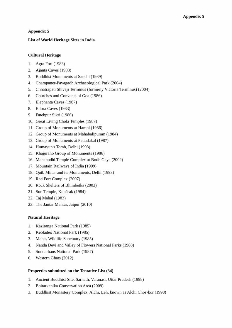
Appendix 5
Appendix 5
List of World Heritage Sites in India
Cultural Heritage
1. Agra Fort (1983) 2. Ajanta Caves (1983) 3. Buddhist Monuments at Sanchi (1989) 4. Champaner-Pavagadh Archaeological Park (2004) 5. Chhatrapati Shivaji Terminus (formerly Victoria Terminus) (2004) 6. Churches and Convents of Goa (1986) 7. Elephanta Caves (1987) 8. Ellora Caves (1983) 9. Fatehpur Sikri (1986) 10. Great Living Chola Temples (1987) 11. Group of Monuments at Hampi (1986) 12. Group of Monuments at Mahabalipuram (1984) 13. Group of Monuments at Pattadakal (1987) 14. Humayun's Tomb, Delhi (1993) 15. Khajuraho Group of Monuments (1986) 16. Mahabodhi Temple Complex at Bodh Gaya (2002) 17. Mountain Railways of India (1999) 18. Qutb Minar and its Monuments, Delhi (1993) 19. Red Fort Complex (2007) 20. Rock Shelters of Bhimbetka (2003) 21. Sun Temple, Konârak (1984) 22. Taj Mahal (1983) 23. The Jantar Mantar, Jaipur (2010) Natural Heritage
1. Kaziranga National Park (1985) 2. Keoladeo National Park (1985) 3. Manas Wildlife Sanctuary (1985) 4. Nanda Devi and Valley of Flowers National Parks (1988) 5. Sundarbans National Park (1987) 6. Western Ghats (2012) Properties submitted on the Tentative List (34)
1. Ancient Buddhist Site, Sarnath, Varanasi, Uttar Pradesh (1998) 2. Bhitarkanika Conservation Area (2009) 3. Buddhist Monastery Complex, Alchi, Leh, known as Alchi Chos-kor (1998)
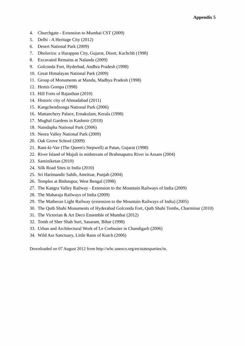
Appendix 5
4. Churchgate - Extension to Mumbai CST (2009) 5. Delhi - A Heritage City (2012) 6. Desert National Park (2009) 7. Dholavira: a Harappan City, Gujarat, Disstt, Kachchh (1998) 8. Excavated Remains at Nalanda (2009) 9. Golconda Fort, Hyderbad, Andhra Pradesh (1998) 10. Great Himalayan National Park (2009) 11. Group of Monuments at Mandu, Madhya Pradesh (1998) 12. Hemis Gompa (1998) 13. Hill Forts of Rajasthan (2010) 14. Historic city of Ahmadabad (2011) 15. Kangchendzonga National Park (2006) 16. Mattanchery Palace, Ernakulam, Kerala (1998) 17. Mughal Gardens in Kashmir (2010) 18. Namdapha National Park (2006) 19. Neora Valley National Park (2009) 20. Oak Grove School (2009) 21. Rani-ki-Vav (The Queen's Stepwell) at Patan, Gujarat (1998) 22. River Island of Majuli in midstream of Brahmaputra River in Assam (2004) 23. Santiniketan (2010) 24. Silk Road Sites in India (2010) 25. Sri Harimandir Sahib, Amritsar, Punjab (2004) 26. Temples at Bishnupur, West Bengal (1998) 27. The Kangra Valley Railway - Extension to the Mountain Railways of India (2009) 28. The Maharaja Railways of India (2009) 29. The Matheran Light Railway (extension to the Mountain Railways of India) (2005) 30. The Qutb Shahi Monuments of Hyderabad Golconda Fort, Qutb Shahi Tombs, Charminar (2010) 31. The Victorian & Art Deco Ensemble of Mumbai (2012) 32. Tomb of Sher Shah Suri, Sasaram, Bihar (1998) 33. Urban and Architectural Work of Le Corbusier in Chandigarh (2006) 34. Wild Ass Sanctuary, Little Rann of Kutch (2006) Downloaded on 07 August 2012 from http://whc.unesco.org/en/statesparties/in.

Appendix 6
Appendix 6
Population of each district of the State of Maharashtra
Population (000)
No. District Total Males Females
1 Mumbai City 3,146 1,712 1,434
2 Mumbai Suburban 9,332 5,025 4,307
3 Thane 11,054 5,879 5,175
4 Raigad 2,635 1,348 1,287
5 Ratnagiri 1,613 760 853
6 Sindhudurg 849 417 432
7 Nashik 6,109 3,164 2,945
8 Dhule 2,049 1,056 993
9 Nandurbar 1,646 835 811
10 Jalgaon 4,224 2,198 2,027
11 Ahmednagar 4,543 2,349 2,194
12 Pune 9,427 4,936 4,491
13 Satara 3,004 1,513 1,491
14 Sangli 2,821 1,436 1,385
15 Solapur 4,316 2,234 2,082
16 Kolhapur 3,874 1,983 1,891
17 Aurangabad 3,696 1,928 1,768
18 Jalna 1,958 1,015 943
19 Parbhani 1,836 946 890
20 Hingoli 1,179 609 570
21 Beed 2,586 1,352 1,233
22 Nanded 3,357 1,733 1,624
23 Osmanabad 1,660 865 796
24 Latur 2,456 1,276 1,179
25 Buldhana 2,588 1,342 1,246
26 Akola 1,819 936 882
27 Washim 1,197 621 575
28 Amravati 2,888 1,483 1,405
29 Yavatmal 2,775 1,426 1,350
30 Wardha 1,296 666 630
31 Nagpur 4,653 2,389 2,265
32 Bhandara 1,199 604 594
33 Gondia 1,322 663 660

Appendix 6
Population (000) No. District
Total Males Females
34 Chandrapur 2,194 1,120 1,074
35 Gadchiroli 1,072 543 529
Economic Survey of Maharashtra 2011-2012 (Directorate of Economics & Statistics, Planning Department, Maharashtra, 2012)

Appendix 7
Appendix 7
Important steps and related sections of the Land Acquisition Act, 1894
No. Section of
the act Description Responsibility Timing
1 -------- Preparation of land acquisition proposal and submit
to District Collector.
Acquiring Body i.e.
Project Proponent
As per the
requirement
2 4 A Preliminary notification and powers of officers
there upon to be published in Official Gazette and in
two daily local newspapers (at least 1 in regional
language) for public notice that the land is being or
required to be needed for public purpose (i.e. cut of
date).
Collector
Joint Measurements by Special Land Acquisition
Officer (SLAO), project proponent, and land
owners.
3 5 Payment for damage. Officer so authorized.
4 5-A Hearing of objections of the persons notified under
sect 4, sub sect 1. Objections shall be made to the
Collector and/or SLAO in writing by concerned
person within 30 days after the issue of the
Notification.
Collector
5 6 Declaration that land is required for public purpose
in Official Gazette and two daily local newspapers
(at least 1 in regional language). It is a conclusive
evidence that the land is needed for public purpose.
Secretary or authorized
officer
6 7 The Collector to take order for the acquisition. Appropriate
Government/
Commissioner
7 8 Land to be marked out, measured and planned. Collector
8 9 Notices to persons interested at convenient places
stating intention of taking possession of land with
payment of claims to compensation for all interests
in such land.
Collector
9 10 Power to require and enforce the making of
statements as to the names and interests.
Collector
10 11 and 11A Enquiry in to the objections to a notice given under
sect.9 , sect 8, to the value of the land and award.
Collector Within a period of 2
years from

Appendix 7
No. Section of
the act Description Responsibility Timing
Period within which award shall be made. declaration date of
publication. If no
award is made entire
proceedings for L.A.
shall lapse.
11 12 Award of the Collector when to be final. The
Collector to give notice of his award to persons not
present when the award is made.
Collector
12 12A Correction of award. Within 6 months
from date of award
13 13and 13A Adjournment of enquiry.
Correction of clerical errors etc to give notices to
persons concerned about the corrections.
Collector --do--
14 14 Power to summon and enforce attendance of witness
and production documents.
Collector
15 15 and 15A Matters to be considered and neglected in
determining the amount of compensation.
Power to call for records etc. for purpose of
satisfying itself as to the legality of any findings or
orders passed etc.
Collector
16 16 Powers to take possession of land which shall there
upon free from all encumbrances.
Collector
17 17 Special powers in case of urgency when appropriate
Government so directs, may on expiration of 15
days from the publication of notice mentioned in
sect 9 ,take possession of any land needed for public
purpose.
Collector
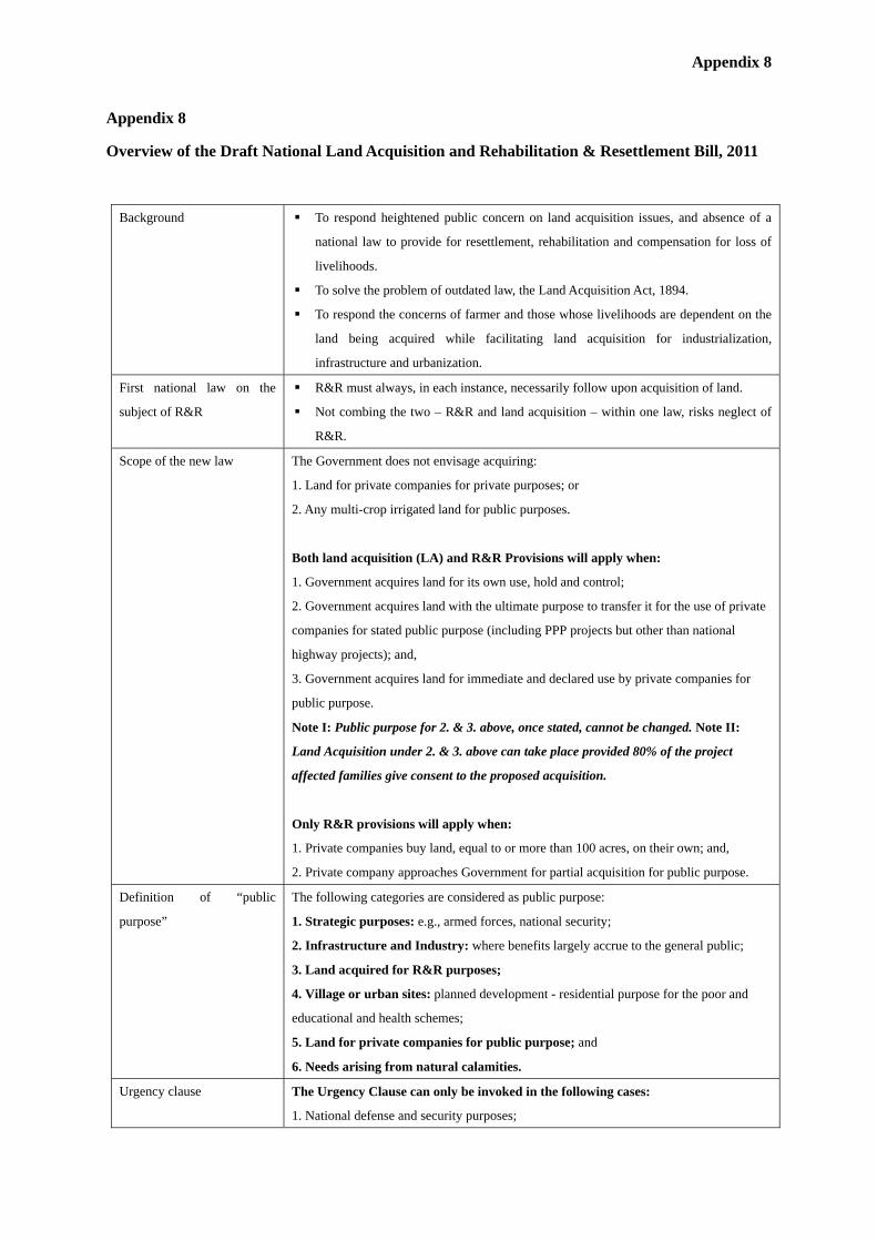
Appendix 8
Appendix 8
Overview of the Draft National Land Acquisition and Rehabilitation & Resettlement Bill, 2011
Background To respond heightened public concern on land acquisition issues, and absence of a
national law to provide for resettlement, rehabilitation and compensation for loss of
livelihoods.
To solve the problem of outdated law, the Land Acquisition Act, 1894.
To respond the concerns of farmer and those whose livelihoods are dependent on the
land being acquired while facilitating land acquisition for industrialization,
infrastructure and urbanization.
First national law on the
subject of R&R
R&R must always, in each instance, necessarily follow upon acquisition of land.
Not combing the two – R&R and land acquisition – within one law, risks neglect of
R&R.
Scope of the new law The Government does not envisage acquiring:
1. Land for private companies for private purposes; or
2. Any multi-crop irrigated land for public purposes.
Both land acquisition (LA) and R&R Provisions will apply when:
1. Government acquires land for its own use, hold and control;
2. Government acquires land with the ultimate purpose to transfer it for the use of private
companies for stated public purpose (including PPP projects but other than national
highway projects); and,
3. Government acquires land for immediate and declared use by private companies for
public purpose.
Note I: Public purpose for 2. & 3. above, once stated, cannot be changed. Note II:
Land Acquisition under 2. & 3. above can take place provided 80% of the project
affected families give consent to the proposed acquisition.
Only R&R provisions will apply when:
1. Private companies buy land, equal to or more than 100 acres, on their own; and,
2. Private company approaches Government for partial acquisition for public purpose.
Definition of “public
purpose”
The following categories are considered as public purpose:
1. Strategic purposes: e.g., armed forces, national security;
2. Infrastructure and Industry: where benefits largely accrue to the general public;
3. Land acquired for R&R purposes;
4. Village or urban sites: planned development - residential purpose for the poor and
educational and health schemes;
5. Land for private companies for public purpose; and
6. Needs arising from natural calamities.
Urgency clause The Urgency Clause can only be invoked in the following cases:
1. National defense and security purposes;

Appendix 8
2. R&R needs in the event of emergencies or natural calamities; and,
3. To be exercised in ‘rarest of rare’ cases.
Affected families Land owners:
1. Family whose land/other immovable properties have been acquired;
2. Those who are assigned land by the Governments under various schemes; and,
3. Right holders under the Forest Rights Act, 2006
Livelihood losers:
1. A family whose livelihood is primarily dependent on the land being acquired; and,
2. May or may not own property.
Compensation 1:
Minimum compensation for
land
A Comprehensive Compensation Package (Schedule I)
1. Market value of the land:
a) the minimum land value, if any, specified in the Indian Stamp Act, 1899 for the
registration of sale deeds in the area, where the land is situated; or
b) the average of the sale price for similar type of land situated in the village or vicinity,
ascertained from fifty per cent of the sale deeds registered during the preceding three
years, where higher price has been paid; or
whichever is higher:
PROVIDED THAT THE MARKET VALUE SO CALCULATED SHALL BE
MULTIPLIED BY THREE IN RURAL AREAS.
2. Value of the assets attached to land:
Building/Trees/Wells/Crop etc as valued by relevant government authority;
Total compensation = 1+2
3. Solatium: 100% of total compensation
This implies that in case of urban areas, the award amount would be not less than twice
that of the market value determined, whereas in rural areas it would be not less than six
times the original market value.
Compensation 2:
Minimum R&R entitlements
A Comprehensive R&R Package (Schedule II and Draft Bill)
For Land Owners:
1. Subsistence allowance at Rs. 3000 per month per family for 12 months;
2. Rs 2000 per month per family as annuity for 20 years, with appropriate index for
inflation;
3. If house is lost, a constructed house of plinth area of 150 sq mts of house site in rural
areas or 50 sq mts plinth area in urban area;
4. One acre of land to each family in the command area, if land is acquired for an
irrigation project;
5. Rs 50,000 for transportation;
6. Where land is acquired for urbanization, 20% of the developed land will be reserved
and offered to land owners, in proportion to their land acquired;
7. Upon every transfer of land within 10 years of the date of acquisition, 20% of the
appreciated value shall be shared with the original owner whose land has been acquired;
8. Mandatory employment for one member per affected family or 2 lakh rupees if
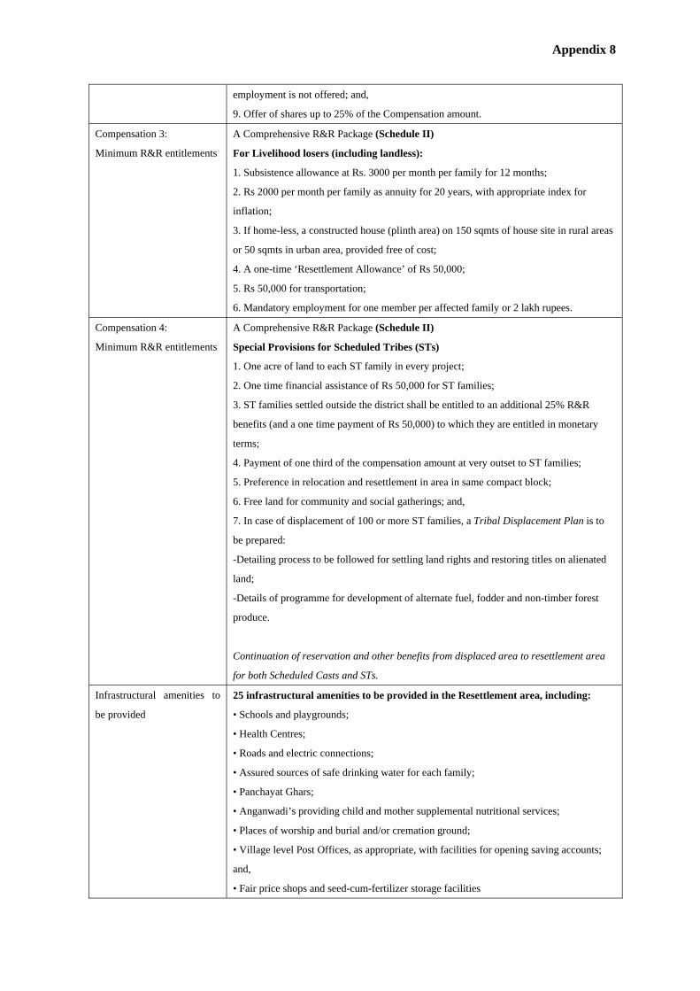
Appendix 8
employment is not offered; and,
9. Offer of shares up to 25% of the Compensation amount.
Compensation 3:
Minimum R&R entitlements
A Comprehensive R&R Package (Schedule II)
For Livelihood losers (including landless):
1. Subsistence allowance at Rs. 3000 per month per family for 12 months;
2. Rs 2000 per month per family as annuity for 20 years, with appropriate index for
inflation;
3. If home-less, a constructed house (plinth area) on 150 sqmts of house site in rural areas
or 50 sqmts in urban area, provided free of cost;
4. A one-time ‘Resettlement Allowance’ of Rs 50,000;
5. Rs 50,000 for transportation;
6. Mandatory employment for one member per affected family or 2 lakh rupees.
Compensation 4:
Minimum R&R entitlements
A Comprehensive R&R Package (Schedule II)
Special Provisions for Scheduled Tribes (STs)
1. One acre of land to each ST family in every project;
2. One time financial assistance of Rs 50,000 for ST families;
3. ST families settled outside the district shall be entitled to an additional 25% R&R
benefits (and a one time payment of Rs 50,000) to which they are entitled in monetary
terms;
4. Payment of one third of the compensation amount at very outset to ST families;
5. Preference in relocation and resettlement in area in same compact block;
6. Free land for community and social gatherings; and,
7. In case of displacement of 100 or more ST families, a Tribal Displacement Plan is to
be prepared:
-Detailing process to be followed for settling land rights and restoring titles on alienated
land;
-Details of programme for development of alternate fuel, fodder and non-timber forest
produce.
Continuation of reservation and other benefits from displaced area to resettlement area
for both Scheduled Casts and STs.
Infrastructural amenities to
be provided
25 infrastructural amenities to be provided in the Resettlement area, including:
• Schools and playgrounds;
• Health Centres;
• Roads and electric connections;
• Assured sources of safe drinking water for each family;
• Panchayat Ghars;
• Anganwadi’s providing child and mother supplemental nutritional services;
• Places of worship and burial and/or cremation ground;
• Village level Post Offices, as appropriate, with facilities for opening saving accounts;
and,
• Fair price shops and seed-cum-fertilizer storage facilities

Appendix 8
Compliance with other laws The Provisions of the New Law shall be fully compliant with other laws such as:
• The Panchayats (Extension to the Scheduled Areas) Act, 1996;
• The Scheduled Tribes and Other Traditional Forest Dwellers (Recognition of Forest
Rights) Act, 2006; and,
• Land Transfer Regulations in Schedule V Areas.
Process flow 1. Proposal received by the appropriate government
2. Pre-notification
• Social Impact Assessment (SIA) conducted by the appropriate government. SIA to be
examined by independent expert group;
• Legitimacy of “public purpose” and SIA is approved by Chief Secretary Committee.
Collector submits report on status of alternative sites, and consent of 80% of affected are
sought.
3. Notification
• Publication of preliminary notification to acquire
• Public hearing
• Finalization of R&R scheme (within six months of pre-notification)
• Draft declaration and R&R scheme published
4. Awards
Institutional structure 1. Central level
• National LA/R&R Dispute Settlement Authority: Dispute resolution for central projects
• National Monitoring Committee: Oversight at central level
2. State level
• State LA/R&R Dispute Settlement Authority: Dispute resolution for state projects
• Chief Secretary Committee: Determine whether projects are for public purpose
• State commissioner R&R: Overall administration for LA and R&R in state
3. Project level
• District Collector: Overall coordination and implementation
• Administrator R&R: Administration for project level R&R
• R&R Committee: Oversight (constituted by elected representatives, civil society and
line agencies)
Safeguards against
indiscriminate acquisition
• Social Impact Assessment made mandatory where area to be acquired is equal to or
greater than 100 acres;
• Chief Secretary Committee to approve ‘public purpose’ and approve the SIA report;
• Draft Notification to include:
– Summary of SIA
– Particulars of Administrator for R&R who prepares R&R scheme
• Draft Declaration to include:
– Summary of R&R package
• Return of Land: Land returned to original owner if not used in 5 years for the purpose
for which it is acquired, one-fourth of the award amount for the land acquired:
– Provided government can use land acquired for a department to some other department
Transparency provisions • Social Impact Assessment

Appendix 8
– Gram Sabha to be consulted
– Summary of SIA notified along with Draft Notification
– SIA document made available for public scrutiny
• R&R Scheme
– Summary notified along with Draft declaration
– Made available for public scrutiny
• Individual Awards passed
• Public Disclosure
– All documents mandatorily to be made available in the public domain and on the
website
Penalties Punishment for false information, Mala Fide action, etc
• If False or Misleading Documents: Will result in the levy of a fine of up to one lakh
rupees and/ or with imprisonment up to a month.
• If R&R benefits obtained on false information:
Shall be recovered by the Appropriate Authority.
• Disciplinary Proceedings against Government Officers: A Government servant who
is guilty of a mala fide action in respect of any provision of this Act and he shall be liable
to such punishment (and fine) as the disciplinary authority may decide.
Awards Collector passes two (2) types of Awards:
1. Award for Land Acquisition
– Award made in respect of every affected family whose land is being acquired and
containing details of LA compensation as listed in Schedule I;
2. Award for R&R
– Award made in respect of every affected family, regardless of whether they may be
losing land or not, containing details of R&R entitlements as listed in Schedule II.
Provided that Land will not be transferred until R&R is completed.
Note: All texts are draft only for discussion only.
A few expressions of the Overview are modified slightly to fit them into the tabular form by the Study Team.

Appendix 9
List of the projects involved land acquisition and rehabilitation & resettlement by Water Resources Department, the Government of Maharashtra
No. Project nameYear
(start and complete)Location
Gross storage(million m3)
Area of landacquisition
(hector)
Number ofaffected villages
Number of affectedpeople
1 Nira Deoghar Major Irrigation Project 1995/2008Pune District. River Nira, tributary ofBhima
337.39 1,5518 fully, 12
partially9,789
2 Tarali Major Irrigation Project1995/Partial Storage
(50%)Satara District. River Tarali, tributary ofKrishna
165 667 7 fully, 8 partially 2,966
3 Dudhganga Mjor Irrigation Project 1977/1998 Kolhapur District. Dudhganga River 719.12 4,6589 fully, 2 Wadiesfully, 1 partially
NA
4 Gunjawani Major Irrigation Project 1998/2009Pune District. River Gunjawani, tributaryof Bhima
104.69 1,174.459 fully, 2 Wadiesfully, 1 partially
7,365
5 Temghar Water Supply Project 1996/2010 Pune District. Mutha River 107.96 553.344 2 fully, 1partially 1,600
6 Chasskaman Major Irrigation Project 1977/2004 Pune District. Bhima River 241.69 2,0759 fully, 19
partiallyNA
7 Warasagaon Major Irrigation Project 1976/1993 Pune District. Mose River 374 2,420 23 Nos NA
8 Warna Major Irrigation Project 1976/2010? Sangli District. Warna River 974.188 8,62418 fully ,9 Wadies
fullyNA
9 Bhama Askhed Major Irrigation Project 1992/2000 Pune District. Bhama River 230.473 2,035.75 3 fully, 5 partially 3,81610 Dhom Balkavadi Major Irrigation Project 1997/2007 Satara District. Krishna River 115.08 606.27 4 fully NA
11 Ghatghar Pumped Storage Scheme 1995/2009Upper Dam on River Pravara, Tributaryof Godavari River. Lower Dam on ShahiRiver, Thane District
Upper dam: 5.5Lowr dam: 3.3
62
upper dam: 1fully
there is no villagein the lower dam
171
12 Urmodi Major Irrigation Project 1997/2011Satara District River Urmodi, tributary ofKrishna
281 1,68911fully, 12
partiallyNA
Notes Data on the dams after year 2000 collected from concerned field divisions and before the year 2000 from A Book on ' Dams in Maharashtra'published in Year 2000 by Water & Land ManagementInstitute,Aurangabad.
Appendix 9

Appendix 10
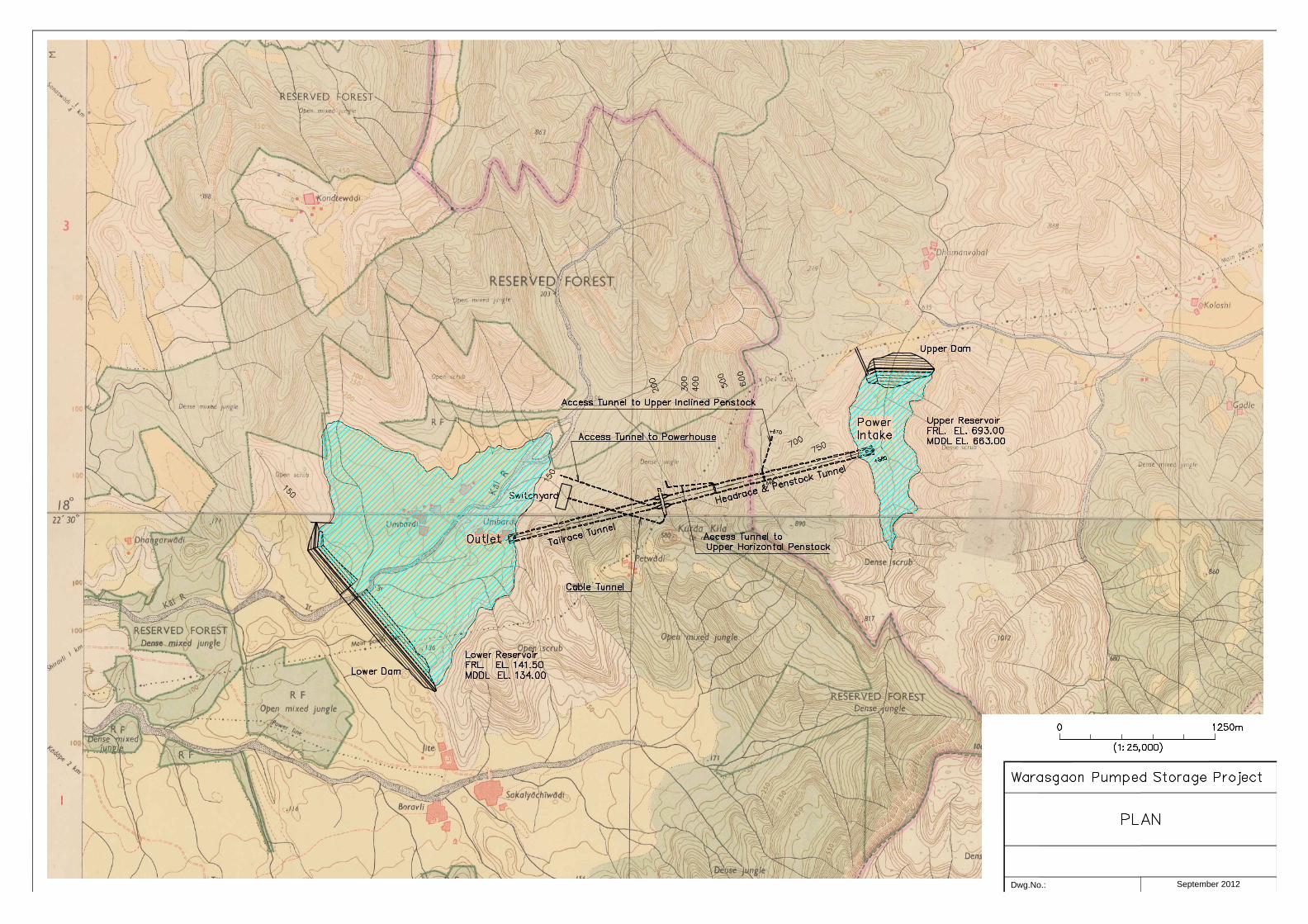
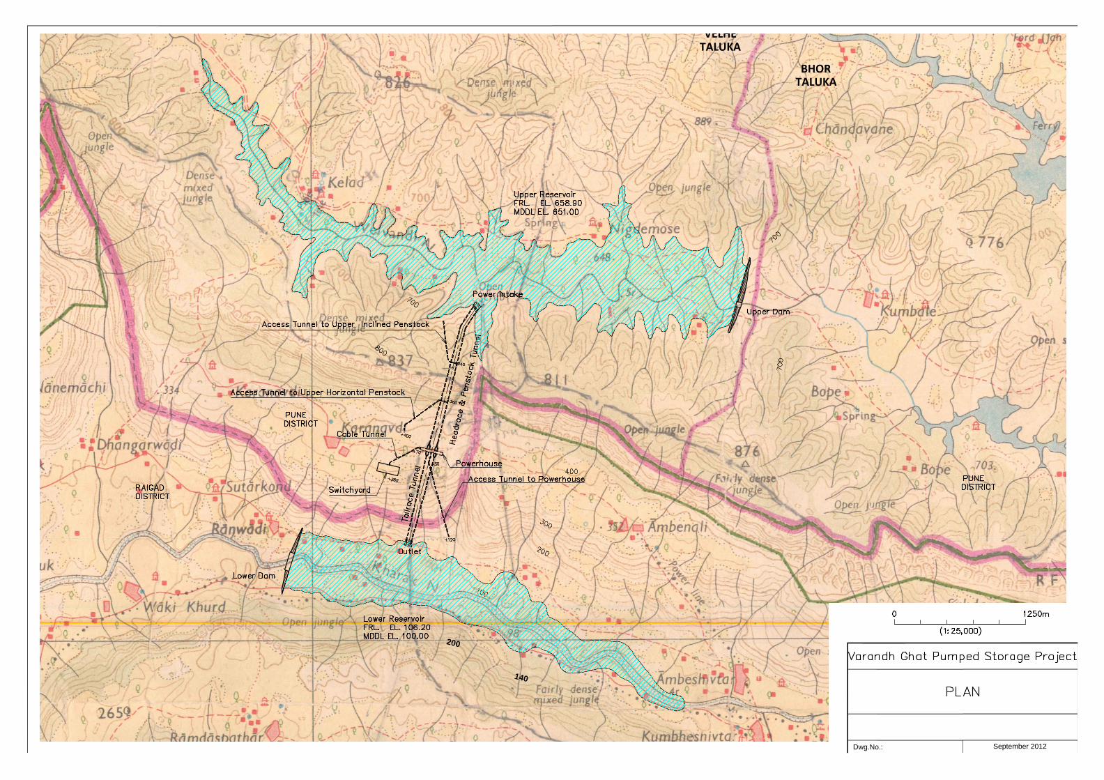
Appendix 10 Drawings Panshet Pumped Storage Project PLAN Panshet Pumped Storage Project PROFILE Warasgaon Pumped Storage Project PLAN Warasgaon Pumped Storage Project PROFILE Varandh Chat Pumped Storage Project PLAN Varandh Chat Pumped Storage Project PROFILE

PUNEDISTRICTRAIGAD
DISTRICT
+200
+480
+470
+190
+170
Upper
September 2012Dwg.No.:
1250m0
(1:25,000)

September 2012Dwg.No.:
0 500m
(1:10,000)
September 2012Dwg.No.:

September 2012Dwg.No.:
200
VELHETALUKA
BHORTALUKA
140
September 2012Dwg.No.:

September 2012Dwg.No.: