appendix m hazards spatial data standards
TRANSCRIPT
Spatial Data Management Plan Appendix M Hazards Spatial Data Standards
Version 5.0 M-1 10 November 2020
APPENDIX M HAZARDS SPATIAL DATA STANDARDS
M.1 Schedule 11 Hazardous Chemicals Spatial Data (HAZCHEM) 1
M.2 Schedule 11 Hazardous Chemicals Map Symbology 4
M.3 Schedule 11 Hazardous Chemicals Map Master Site Plan layers 6
M.4 Schedule 11 Hazardous Chemicals Workplace Site Map Checklist 10
M.5 Hazardous Areas Spatial Data 13
M.6 UXO Spatial Data 15
M.7 Training Area UXO HAZARD Data 18
M.8 Training Area UXO HAZARD Maps 19
Table M-1 Defence HAZCHEM Spatial Data Attributes 1
Table M-2 Defence HAZCHEM_PT Spatial Data Attributes 3
Table M-3 Schedule 11 Hazardous Chemicals Map Symbology 4
Table M-4 Schedule 11 Hazardous Chemicals Master Site Plan Layers 6
Table M-5 Schedule 11 Hazardous Chemicals Workplace Site Map Checklist 10
Table M-6 Hazardous Areas Spatial Data Attributes 13
Table M-7 UXO Spatial Data Attributes 15
Table M-8 UXO Risk Area Hazard Map Symbology 17
Table M-9 Training Area UXO Hazard Spatial Data Attributes 18
Table M-10 Training Area UXO Hazard Map Symbology 19
M.1 SCHEDULE 11 HAZARDOUS CHEMICALS SPATIAL DATA (HAZCHEM)
The following table describes the information to be captured for each polygon feature in the
schedule 11 hazardous chemicals HAZCHEM spatial data.
Table M-1 Defence HAZCHEM Spatial Data Attributes
Field Name
Description
Field Data
Type Values
STATEM State abbreviation Text
3 Char E.g. NSW
PROP_IDM
Property EBI sourced
from GEMS
Text
4 Char
E.g. 3098, these must be padded with
leading zero characters for Prop_DIs less
than 1000, e.g. “0089”
PROP_NAMEM Name of Property,
sourced from GEMS
Text
254 Char E.g. RAAF Base Darwin

Spatial Data Management Plan Appendix M Hazards Spatial Data Standards
Version 5.0 M-2 10 November 2020
Field Name
Description
Field Data
Type Values
MAN_POLYM
Unique identifier for
each polygon
representing an area
or structure
containing a manifest
quantity of
Hazardous chemicals
Text
10 Char
These will adhere to the following
numbering schema:
PPPP-NNNN
Where: PPPP is the GEMS Property EBI
the feature is within and
NNNN is a sequential number starting at
0001 for each property.
E.g.: “0089-0010”
Being feature 10 on Property 0089.
COMCAR_REFO
Unique identifier
allocated by
Comcare for the
Workplace the
feature contributes to
(if known)
Text
10 Char E.g. WP208 (if known)
DEMS_IDM
Where a polygon
feature aligns with an
existing asset such as
a building, structure,
compound, tank or
container the GEMS
asset number of the
asset must be
recorded in this field.
Text
50 Char
E.g. “0009/A0102”.
Special cases:
“Unknown”: Where a GEMS asset
number cannot be determined for an
existing feature.
“Null”: When the polygon representing a
HAZCHEM polygon does not correspond
with an existing asset, structure or tank.
DESCRIPTM
Description of the
Schedule 11
Hazardous Chemical
Text
254 Char
Sourced from the manifest sections of the
relevant Notification / Manifest
E.g. “F76 Navy Distillate”
CODE_SYSTM
A flag to indicate
which Dangerous
Goods coding system
is used in the
HAZCHEMCOD
field
Text
3 Char
One of the following two values may be
used:
GHS :where the Global Harmonised
System is used;
ADG : where the Australian Code for the
Transport of Dangerous Goods is used.
HAZCHEMCODM
Hazard category or
the Dangerous Goods
class / division for
either the GHS or
ADG classification
systems
Text
50 Char
The values must align with the Dangerous
Goods class and division for the system
indicated in the CODE_SYST field.
E.g. where GHS is indicated in the
CODE_SYST a quantity of Diesel fuel
greater than 100,000lt the value of this
field would be “Cat 4 – Flammable
Liquids”

Spatial Data Management Plan Appendix M Hazards Spatial Data Standards
Version 5.0 M-3 10 November 2020
Field Name
Description
Field Data
Type Values
REMARKSO
To be used to record
any information that
may alert a user to an
issue with the data or
the polygon
representing the
extent of an area
containing a manifest
quantity of
Hazardous
chemicals.
Text
254 Char E.g. Extent is approximate
Notes:
M = a mandatory field, i.e. this field must be completed.
O = an optional field that may be left blank.
The following table describes the information to be captured for each point feature in the
schedule 11 hazardous chemicals HAZCHEM_PT spatial data.
Table M-2 Defence HAZCHEM_PT Spatial Data Attributes
Field Name Description Field Data
Type Values
PROP_IDM Property EBI sourced
from GEMS
Text
4 Char
E.g. 3098, these must be padded with
leading zero characters for Prop_IDs less
than 1000, e.g. “0089”
PROP_NAMEM Name of Property,
sourced from GEMS
Text
254 Char E.g. RAAF Base Darwin
TypeM Text
254 Char
This field must contain one of the
following values:
Value Description
SDS Safety Data Sheet
Manifest Includes Type,
quantity and
Locations of
Hazardous
Chemicals
Emergency Spill
Kit
Spill Kits contain a
range of absorbents
and accessories that
allow operators to
quickly contain and
clean up spills
Fire Indicator
Panel
First Aid Kit
Emergency
Shower
Eye Wash
Station

Spatial Data Management Plan Appendix M Hazards Spatial Data Standards
Version 5.0 M-4 10 November 2020
Field Name Description Field Data
Type Values
Evacuation
Assembly Area
Fire
Extinguisher See sub-type
Sub-typeC Text
254 Char
If the Type field is set to “Fire
Extinguisher”, this field must contain
one of the following values:
DCP
Foam
Water
CO2
Other
CommentO
To be used to record
any information that
may alert a user to an
issue with the data or
the point.
Text
254 Char E.g. Location is approximate
Notes:
M = a mandatory field, i.e. this field must be completed.
C = Conditional, dependant on the value set in the Type field.
O = an optional field that may be left blank.
M.2 SCHEDULE 11 HAZARDOUS CHEMICALS MAP SYMBOLOGY
The following table provides the details of the required symbology for schedule 11 hazardous
chemicals (HAZCHEM) workplace site mapping.
Any patterns and symbol scales should be adjusted depending on the extent of the map
coverage. (i.e. final plot scale)
Table M-3 Schedule 11 Hazardous Chemicals Map Symbology
Legend Items Symbology
HAZCHEM Area
Manifest
SDS
Fire Extinguisher – Dry Chemical
Powder
Fire Extinguisher – Foam
Fire Extinguisher – Water
Fire Extinguisher – CO2
Fire Indicator Panel
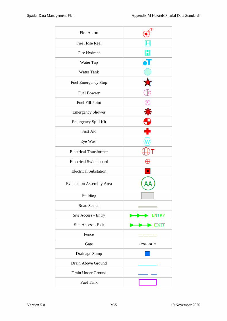
Spatial Data Management Plan Appendix M Hazards Spatial Data Standards
Version 5.0 M-5 10 November 2020
Fire Alarm
Fire Hose Reel
Fire Hydrant
Water Tap
Water Tank
Fuel Emergency Stop
Fuel Bowser
Fuel Fill Point
Emergency Shower
Emergency Spill Kit
First Aid
Eye Wash
Electrical Transformer
Electrical Switchboard
Electrical Substation
Evacuation Assembly Area
Building
Road Sealed
Site Access - Entry
Site Access - Exit
Fence
Gate
Drainage Sump
Drain Above Ground
Drain Under Ground
Fuel Tank

Spatial Data Management Plan Appendix M Hazards Spatial Data Standards
Version 5.0 M-6 10 November 2020
Fuel Pipe Aboveground
Fuel Pipe Underground
Gas Tank
Gas Pipe
M.3 SCHEDULE 11 HAZARDOUS CHEMICALS MAP MASTER SITE PLAN
LAYERS
The following table provides the recommended Master Site Plan layers to be used for the base
map (background) for schedule 11 hazardous chemicals (HAZCHEM) workplace site maps
Table M-4 Schedule 11 Hazardous Chemicals Master Site Plan Layers
Layer Colour
DR_AGDRAIN_UG Blue
DR_CULVERT Blue
DR_DNPIPE_TO_DR Blue
DR_GRATED_LINED Blue
DR_HEADWALL Blue
DR_HEDWL Blue
DR_OP_LINED Blue
DR_OP_LINED_DR Blue
DR_OP_UNLINED Blue
DR_OP_UNLINED_DR Blue
DR_PIPE_UG Blue
DR_PIPE_UG_FR Blue
DR_PUMP_STAT Blue
DR_SURFACE Blue
DR_TRAP_GULLY Blue
EL_CABLE _AG Red
EL_CABLE_HV_AG Red
EL_CABLE_HV_UG Red

Spatial Data Management Plan Appendix M Hazards Spatial Data Standards
Version 5.0 M-7 10 November 2020
Layer Colour
EL_CABLE_UG_FR Red
EL_GENERATOR Red
EL_OUTLET Red
EL_PE_CELL Red
EL_TOWER Red
FI_CABLE_UG RGB 197, 0, 255
FI_MISC RGB 197, 0, 255
FI_PILLAR_NETWORK RGB 197, 0, 255
FI_REEL RGB 197, 0, 255
FU_PIPE_UG RGB 197, 0, 255
FU_TANK_AG RGB 197, 0, 255
GA_METER Grey
GA_MISC Grey
GA_PIPE_AG Grey
GA_PIPE_UG Grey
GA_PIPE_UG_ABD Grey
GA_PIPE_UG_UN Grey
GA_REG Grey
GA_REG_DIST Grey
GA_TANK_LPG Grey
GA_VALVE_AG Grey
GA_VALVE_UG Grey
GA_VENT Grey
RD_CARPARK Black
RD_CARPARK_LINE_MARKING Black
RD_DRIVEWAY Black

Spatial Data Management Plan Appendix M Hazards Spatial Data Standards
Version 5.0 M-8 10 November 2020
Layer Colour
RD_GUIDE_POST Black
RD_KERB Black
RD_KERB_MOUNT Black
RD_KERB_STD Black
RD_PATH Black
RD_SEALED Black
RD_UNSEALED Black
SE_TANK_SEPTIC_AG RGB 255, 211, 127
SE_TANK_SEPTIC_UG RGB 255, 211, 127
SE_TRADE_TANK_UG RGB 255, 211, 127
SE_TRAP_GREASE RGB 255, 211, 127
SE_VENT RGB 255, 211, 127
ST_AWNING Black
ST_BBQ Black
ST_BOLLARD Black
ST_BUILDING Black outline, grey infill
ST_COLUMN_SUPPORT Black
ST_DIMENSIONS Black
ST_FENCE Black
ST_FENCE POST Black
ST_FLAG_POLE Black
ST_GATE Black
ST_GATE_BOOM Black
ST_HATCH TEMP Black
ST_INCINERATOR Black
ST_MISC Black

Spatial Data Management Plan Appendix M Hazards Spatial Data Standards
Version 5.0 M-9 10 November 2020
Layer Colour
ST_MONITORING_WELLS Black
ST_MONUMENT Black
ST_PATIO_DECK Black
ST_PAVEMENT Black
ST_PERGOLA Black
ST_PLAT_PLINTH_EDGE Black
ST_RAILING Black
ST_RAMP Black
ST_ROOFLINE_EAVES Black
ST_SHADE_STRUCTURE Black
ST_SHED Black
ST_SIGN Black
ST_STEPS Black
ST_SWIM_POOL Black
ST_TEMP_BLDG Black
ST_TEXT Black
ST_VERANDAH Black
ST_WALL Black
ST_WALL_RET Black
WS_CAP_END_AG RGB 0, 255, 197
WS_CAP_END_UG RGB 0, 255, 197
WS_FOUNTAIN_DRINK RGB 0, 255, 197
WS_HATCH RGB 0, 255, 197
WS_HOSE_BOX_REEL RGB 0, 255, 197
WS_HW_TANK RGB 0, 255, 197
WS_HYD_GROUND RGB 0, 255, 197

Spatial Data Management Plan Appendix M Hazards Spatial Data Standards
Version 5.0 M-10 10 November 2020
Layer Colour
WS_IR_CONTROL RGB 0, 255, 197
WS_IR_PIPE_UG RGB 0, 255, 197
WS_PIPE_AG RGB 0, 255, 197
WS_PIPE_FIRE RGB 0, 255, 197
WS_PIPE_HW RGB 0, 255, 197
WS_PIPE_UG_FIRE RGB 0, 255, 197
WS_PUMP RGB 0, 255, 197
WS_TANK_AG RGB 0, 255, 197
WS_THRUST_BLOCK RGB 0, 255, 197
M.4 SCHEDULE 11 HAZARDOUS CHEMICALS WORKPLACE SITE MAP
CHECKLIST
The following table is provided for the purposes of verifying the details shown on Workplace
site maps are complete and accurate. Where workplace site maps are provided to stakeholders
for review, i.e. regional personnel, one of these sheets should accompany each map. A
template is on the Defence Estate Quality management System (DEQMS) at the following
location:
http://www.defence.gov.au/estatemanagement
Table M-5 Schedule 11 Hazardous Chemicals Workplace Site Map Checklist
Items Value
GEMS Property EBI
GEMS Property name
State
Name of Workplace
Regional Site Reference
Example Items Value
GEMS Property EBI 0089
GEMS Property name Garden Island – HMAS STIRLING – Fleet Base West
State WA
Name of Workplace DEFENCE FUEL INSTALLATION
Regional Site Reference B0116
Map Feature to Check Y / N Corrective Action
HAZCHEM areas are shown
and location(s) is correct?
(Bulk, packaged, in transit,
manufactured)

Spatial Data Management Plan Appendix M Hazards Spatial Data Standards
Version 5.0 M-11 10 November 2020
Map Feature to Check Y / N Corrective Action
HAZCHEM identification
is correct (chemicals,
quantity, container id’s)?
NOTE: These details must match the details in the Manifest
document.
Location of Manifest
document is correctly
shown?
Manifest location
description is correct (See
note below locality map)
Confirm workplace
address (below the
Comcare reference box) is
correct?
Main gate position
correctly shown in the
locality map?
All Entry/Exit points into
the workplace are shown
& correct?
All Buildings, amenities,
fences, car parks and
storage areas are shown?
GEMS building numbers
& descriptions correct?
Road names are shown
and correct?
Fire Extinguishers are
shown by type?
Hydrants and hose reels
are shown by type?
Evacuation Assembly
Area location is shown? NOTE: show direction and distance if unable to be shown in the
maps main body
Any other emergency or
safety features that need to
be shown?
Fuel/Gas features shown
& correct?
All Emergency Stop
Switch shown & correct?
Major Power Features
shown & correct e.g.
transformers?
Location of Drains shown
& correct?

Spatial Data Management Plan Appendix M Hazards Spatial Data Standards
Version 5.0 M-12 10 November 2020
Map Feature to Check Y / N Corrective Action
Other relevant features
required? e.g. description
of adjoining workplaces
and activities carried out
there is shown and
correct?
Date of preparation /
revision is shown and
correct?
Includes north point and
scale bar?
Does the Legend identify
all features shown on the
map?

Spatial Data Management Plan Appendix M Hazards Spatial Data Standards
Version 5.0 M-13 10 November 2020
M.5 HAZARDOUS AREAS SPATIAL DATA
The following table describes the information to be captured for each feature in the Hazardous
Areas Spatial data.
Table M-6 Hazardous Areas Spatial Data Attributes
Field Name Description Field Data
Type Values
STATEM State abbreviation Text
3 Char e.g. NSW
PROP_IDM Property EBI sourced
from GEMS
Text
4 Char
e.g. 3098, these must be padded with
leading zero characters for Prop_IDs less
than 1000, e.g. “0089”
PROP_NAMEM Name of Property,
sourced from GEMS
Text
50 Char e.g. RAAF Base Darwin
HAZ_NOM
Unique identifier for
each polygon
representing a
hazardous area.
Text
10 Char
The hazard number must adhere to the
following numbering schema:
PPPP-NNNN
Where: PPPP is the GEMS property
number the feature is within and
NNNN is a sequential number starting at
0001 for each property.
The hazard number must align with the
value entered in the associated Hazardous
Areas Register for the affected Asset.
E.g. “0089-0010”
Being feature 10 on Property 0089
An alpha suffix may be appended to the
number in the following circumstances:
1. Where an existing hazardous area is to
be sub-divided in to multiple areas an
Alpha suffix may be added to each of the
sub-divisions:
E.g. where an existing area is split
into two polygons: the first sub-division
will be numbered as “0089-0010A” and
the second will be numbered as “0089-
0010B”.
2. Where multiple hazards exist within
the same structure or building.

Spatial Data Management Plan Appendix M Hazards Spatial Data Standards
Version 5.0 M-14 10 November 2020
Field Name Description Field Data
Type Values
ASSET_NOM
Where a polygon
feature aligns with or
is adjacent to an
existing asset or
assets such as a
building, structure,
compound, tank or
container the GEMS
asset number of the
asset must be
recorded in this field.
Text
50 Char
e. .g. “0009/A0102”.
Special cases:
“Unknown” : Where a GEMS asset
number cannot be determined for an
existing feature.
“NA” : When the polygon representing a
polygon does not correspond with an
existing asset, structure or tank.
“Multiple Assets” : Where a polygon
covers multiple assets>
COMMENTSO
To be used to record
any information that
may alert a user to an
issue with the data or
the polygon
representing the
extent of a hazardous
area
Text
254 Char
E.g. “Near 0089/B0081
Or “Hazard over multiple assets”
HA_STATUSM
Flags to the user if
the Hazardous Area
is current or has been
remediated and is no
longer considered to
be hazardous
Text
7 Char
Allowable values are:
Current: the polygon represents an area
that has been identified and is currently
considered to be a Hazardous Area.
Retired: the polygon represents an area
that was once identified as a Hazardous
Area, but has undergone remediation and
is no longer considered a Hazardous
Area.
LINKO
The URL to a record
held on another
system relevant to
this feature.
Text
254 Char
Notes: M = a mandatory field, i.e. this field must be completed. O = an optional field that may be left blank.

Spatial Data Management Plan Appendix M Hazards Spatial Data Standards
Version 5.0 M-15 10 November 2020
M.6 UXO SPATIAL DATA
The following table describes the information to be captured for each feature in Unexploded
Ordnance (UXO) Spatial data.
Table M-7 UXO Spatial Data Attributes
Field Name Description Field Data
Type Values
SITEIDM
The unique
identifier for the
UXO affected
polygon
Text
7 Char
To be in the form:
SSSNNN.
Where:
SSS is a two-three letter code for
State/Territory as follows:
ACT, NSW, VIC, TAS, SA, WA, NT,
QLD, JBT, EXT*
Or
SSS is a three letter code for Sea
Dumping sites as follows:
DEP : Sites of Depth Charge
usage
SDC : Dumping sites for
Chemical munitions
SDG : Sea Dumping sites for
other ordnance and associated
material
NNN is a sequential number (integer)
padded with leading zeros. E.g. 012.
Identifiers are to be sequential and are
NOT to be re-used in the event that an
area is retired or deleted.
* To be used for all external territories
SUBSITEIDC
A unique identifier
for a UXO polygon
that is a child of a
parent site.
Text
1 Char
To be in the form:
A
where is “A” is a one letter code in the
range A to Z in alphabetical order.
Codes are to be used in alphabetical order
and are NOT to be re-used in the event
that a sub-site is retired or deleted.
If a polygon is NOT a sub-site this field is
to be blank (or null).
LegacyIDO
The unique ID
sourced from a
contributor’s
dataset
Text
128 Char
Identifier as used in the data the polygon
was sourced from. E.g. 38

Spatial Data Management Plan Appendix M Hazards Spatial Data Standards
Version 5.0 M-16 10 November 2020
Field Name Description Field Data
Type Values
NAMEM Text
254 Char e.g. “Bankstown”
STATEM
The State or
Territory in which
the polygon lies
Text
3 Char
e.g. NSW.
Where an area lies outside
State/Territorial waters it should be coded
to “Com”.
CATEGORYID M
Code used to
indicate the
potential for UXO
within the area
encompassed by
the polygon.
Integer
2 Char
The field may have one of the following
values:
1 – Substantial potential;
2 – Slight potential;
3 – Remote;
4 – Information.
5 – Other
6 - Sites of Depth Charge usage
7 - Dumping sites for Ordnance and
associated material including Chemical
Munitions
DESCRIPTI1O Description of the
UXO affected area,
Text
254 Char
The field should contain a narrative
description of the site, its location, the
nature of the UXO contamination, any
historically relevant information and any
external references.
DESCRIPTI2O Overflow field for
long Descriptions.
Text
254 Char
This field is to be used as an overflow for
descriptions that exceed 254 characters
and should contain the description from
and including the 255th character
onwards.
REPORTO Report Title Text
254 Char
The title of the report documenting the
UXO site.
REFERENCEM Reference to the
UXO information.
Text
254 Char
This field must contain a reference to the
source(s) of information used to make an
assessment of the UXO potential.
Typically this would be a file number or a
Defence project number.
COMMONWLTHO
Field used to
indicate the
Commonwealth
land status of the
land polygon lies
within.
Text
30 Char
The field may have one of the following
values:
Not Commonwealth land
Commonwealth land
Contains Commonwealth land

Spatial Data Management Plan Appendix M Hazards Spatial Data Standards
Version 5.0 M-17 10 November 2020
Field Name Description Field Data
Type Values
MEDIUMM
Flag to indicate the
geography type the
polygon lies within.
Text
16 Char
The field may have one of the following
values:
Land – to be used where a polygon covers
land;
Water - to be used where a polygon
covers only water (inland or sea).
Land and Water – to be used where a
polygon straddles the coastline
with a portion covering land and
a portion covering water.
Island- (to be used when a polygon totally
covers an island and its
surrounding waters)
ACCESSLVLM
Code to indicate
which user groups
are to have
visibility of the
polygon
Text
7 Char
The field may have one of the following
values:
Defence – indicate that the polygon is for
internal Defence use only;
Public - indicates that the polygon is able
to be released to the public.
Retired – indicates that the site is no
longer considered valid or
contains no likelihood of the
presence of UXO.
Notes: M = a mandatory field, i.e. this field must be completed. O = an optional field that may be left blank. C = must be populated under certain conditions. E.g. if a UXO polygon is a sub-site.
Table M-8 UXO Risk Area Hazard Map Symbology
Legend Item Symbol
Risk Level Categories
Code Description Style, RGB Colour Example
1 Substantial Potential Outline (2pt) & Fill:
R : 255
G : 0
B : 0
Fill: 70% transparency
2 Slight Potential Outline (2pt) & Fill:
R : 255
G : 170
B : 0
Fill: 70% transparency

Spatial Data Management Plan Appendix M Hazards Spatial Data Standards
Version 5.0 M-18 10 November 2020
Legend Item Symbol
3 Remote Outline (2pt) & Fill:
R : 215
G : 180
B :200
Fill: 70% transparency
4 Information Outline (2pt) & Fill:
R : 137
G : 205
B : 102
Fill: 70% transparency
5 Other Outline (2pt) &
Fill:
R : 255
G : 255
B : 0
Fill: 70% transparency
6 Site of Depth Charge usage Outline (2pt) &
Fill:
R : 0
G : 112
B : 255
Fill: 70% transparency
7 Sea Dumping Sites Outline (2pt) &
Fill:
R : 0
G : 112
B : 255
Fill: 70% transparency
M.7 TRAINING AREA UXO HAZARD DATA
The following table describes the information to be captured for each feature in the Training
Area UXO Hazard Spatial data.
Table M-9 Training Area UXO Hazard Spatial Data Attributes
Field Name Description Field Data
Type Values
HAZ_IDM
The unique number
for the UXO
affected polygon
Integer
1 to 999999. Numbers are to be
sequential and are NOT to be re-used in
the event that an area is retired or deleted.

Spatial Data Management Plan Appendix M Hazards Spatial Data Standards
Version 5.0 M-19 10 November 2020
Field Name Description Field Data
Type Values
HAZ_LEV M
Code used to
indicate the
potential for UXO
within the area
encompassed by
the polygon.
Integer
2 Char
The field may have one of the following
values:
0 – Unscored;
1 –Extremely Hazardous;
2 – Substantial Explosive Potential;
3 – Moderate Explosive Potential;
4 – Low Explosive Potential;
5 - No Explosive Potential
PROP_NAME M
The name of the
Training
Area/Property.
Text
50 Char
The name of the Training Area/Property
as used in the Defence system – GEMS.
NOGOTYPEO
Text describing the
types of
uses/activities
allowed in the area
Text
150 Char
e.g. “4-Low explosive potential. Uses are
acceptable”,
“2-Substantial explosive potential. Uses
are beyond normal tolerance for risk.”
AREAIDO Abbreviated Area
identifier
Text
15 Char
Code used to describe areas on a Training
Area. E.g. “DTA6”, “FFA5”
NAMEO
Name of the UXO
hazard area if one
is in use.
Text
50 Char e.g. “Range Impacts Area D”
SOURCEM Reference to UXO
information.
Text
254 Char
This field must contain a reference to the
source(s) of information used to make an
assessment of the UXO potential.
Typically, this would be a file number,
Report title and or a Defence project
number.
Notes: M = a mandatory field, i.e. this field must be completed. O = an optional field that may be left blank.
M.8 TRAINING AREA UXO HAZARD MAPS
The following table provides the details of the required symbology for Training Area UXO
Hazard mapping.
Any patterns and symbol scales should be adjusted depending on the extent of the map
coverage. (i.e. final plot scale).
Table M-10 Training Area UXO Hazard Map Symbology
Legend Item Symbol
Hazard level Categories
Code Description Style, RGB Colour Example

Spatial Data Management Plan Appendix M Hazards Spatial Data Standards
Version 5.0 M-20 10 November 2020
Legend Item Symbol
1 Extremely Hazardous R : 244
G : 140
B : 140
2 Substantial Explosive Potential R : 244
G : 209
B : 140
3 Moderate Explosive Potential R : 239
G : 239
B :140
4 Low Explosive Potential R : 140
G : 229
B : 255
5 No Explosive Potential R : 178
G : 244
B : 140
Unscored R : 242
G : 242
B : 242
Property Boundary Dashed Black 1.33
Pt on Grey (R204,
G204, B204) 4 Pt
Sector Boundaries Dashed Pink
(R255,G127,B224)
1.1 Pt on White
outline 2 Pt
Current Range Boundary/Impact Area Dash Black 1 Pt on
White outline 1 Pt
Former Range Boundary/Impact Area Dashed Orange
(255R, 170G, 0B)
1.25Pt on White
outline 1.5Pt
Camp or Admin Area Black 0.45 Pt
Special Use/Restricted Area Orange (255R
170G 0B) border (
and hatching (0.25
Pt, 45o, 4 Pt

Spatial Data Management Plan Appendix M Hazards Spatial Data Standards
Version 5.0 M-21 10 November 2020
Legend Item Symbol
separation))
Cleared Road Blue (R0, G197,
255B) 0.8Pt on
white outline 1.5Pt
Cleared Track Blue dashed (R0,
G197, 255B) 1.0Pt
on white outline
1.2Pt
Labels: Sectors, Impact Areas, Camp or
Admin Areas, Special Use/Restricted Areas
Arial, Black on White halo.