application development in web mapping 3. - wms/wfs server -...
TRANSCRIPT

University of West Hungary, Faculty of Geoinformatics
László Kottyán
Application Developmentin Web Mapping 3.
module ADW3
WMS/WFS Server
SZÉKESFEHÉRVÁR
2010
The right to this intellectual property is protected by the 1999/LXXVI copyrightlaw. Any unauthorized use of this material is prohibited. No part of this product
may be reproduced or transmitted in any form or by any means, electronic ormechanical, including photocopying, recording, or by any information storage and
retrieval system without express written permission from the author/publisher.
This module was created within TÁMOP - 4.1.2-08/1/A-2009-0027 "Tananyagfejlesztéssel aGEO-ért" ("Educational material development for GEO") project. The project was fundedby the European Union and the Hungarian Government to the amount of HUF 44,706,488.
Lector:
Antal Guszlev
Project manager:
András Szepes
Professional project manager:
Gábor Mélykúti, dean
Copyright © University of West Hungary Faculty of Geoinformatics 2010
Table of Contents3. WMS/WFS Server . . . . . . . . . . . . . . . . . . . . . . . . . . . . . . . . . . . . . . . . . . . . . . . . . . . . . . . . . . . . . . . . . . . . . . . . . . . . . . . . . . . . . . . . . . . . . . . . . . . . . . . . . . . . . . . . . . 1
3.1 Introduction . . . . . . . . . . . . . . . . . . . . . . . . . . . . . . . . . . . . . . . . . . . . . . . . . . . . . . . . . . . . . . . . . . . . . . . . . . . . . . . . . . . . . . . . . . . . . . . . . . . . . . . . . . . . . . . . 13.2 About GeoServer . . . . . . . . . . . . . . . . . . . . . . . . . . . . . . . . . . . . . . . . . . . . . . . . . . . . . . . . . . . . . . . . . . . . . . . . . . . . . . . . . . . . . . . . . . . . . . . . . . . . . . . . . 1
3.2.1 Installing GeoServer . . . . . . . . . . . . . . . . . . . . . . . . . . . . . . . . . . . . . . . . . . . . . . . . . . . . . . . . . . . . . . . . . . . . . . . . . . . . . . . . . . . . . . . . . . . 13.2.2 Data Directory . . . . . . . . . . . . . . . . . . . . . . . . . . . . . . . . . . . . . . . . . . . . . . . . . . . . . . . . . . . . . . . . . . . . . . . . . . . . . . . . . . . . . . . . . . . . . . . . . . 53.2.3 Administration interface . . . . . . . . . . . . . . . . . . . . . . . . . . . . . . . . . . . . . . . . . . . . . . . . . . . . . . . . . . . . . . . . . . . . . . . . . . . . . . . . . . . . . . 63.2.4 Data storing . . . . . . . . . . . . . . . . . . . . . . . . . . . . . . . . . . . . . . . . . . . . . . . . . . . . . . . . . . . . . . . . . . . . . . . . . . . . . . . . . . . . . . . . . . . . . . . . . . . . . . 7
3.3 Working with layers . . . . . . . . . . . . . . . . . . . . . . . . . . . . . . . . . . . . . . . . . . . . . . . . . . . . . . . . . . . . . . . . . . . . . . . . . . . . . . . . . . . . . . . . . . . . . . . . . . . 143.3.1 Adding layers . . . . . . . . . . . . . . . . . . . . . . . . . . . . . . . . . . . . . . . . . . . . . . . . . . . . . . . . . . . . . . . . . . . . . . . . . . . . . . . . . . . . . . . . . . . . . . . . . 143.3.2 Viewing layers . . . . . . . . . . . . . . . . . . . . . . . . . . . . . . . . . . . . . . . . . . . . . . . . . . . . . . . . . . . . . . . . . . . . . . . . . . . . . . . . . . . . . . . . . . . . . . . . . 173.3.3 Grouping layers . . . . . . . . . . . . . . . . . . . . . . . . . . . . . . . . . . . . . . . . . . . . . . . . . . . . . . . . . . . . . . . . . . . . . . . . . . . . . . . . . . . . . . . . . . . . . . . 18
3.4 Web Map Service . . . . . . . . . . . . . . . . . . . . . . . . . . . . . . . . . . . . . . . . . . . . . . . . . . . . . . . . . . . . . . . . . . . . . . . . . . . . . . . . . . . . . . . . . . . . . . . . . . . . . . . 193.5 Web Feature Service . . . . . . . . . . . . . . . . . . . . . . . . . . . . . . . . . . . . . . . . . . . . . . . . . . . . . . . . . . . . . . . . . . . . . . . . . . . . . . . . . . . . . . . . . . . . . . . . . . . 23

Chapter 3. WMS/WFS Server
3.1 IntroductionThe Open Geospatial Consortium (OGC) in Web Map Service (WMS) and Web Feature Service (WFS) specifi-cations defines the way how to serve geospatial raster and vector data to clients through networks, includingthe Internet.
There are several software providers which implement OGC Web Services (OWS) in their desktop or web prod-ucts1.
One great open source server solution is the Java-based GeoServer.
In this module there will be:
• given instructions about GeoServer installation on Windows XP and Ubuntu 10.4 operating systems,
• reviewed the administration interface of GeoServer, including data management possibilities,
• added some layers to the server,
• demonstrated the geospatial data serving according to WMS and WFS.
3.2 About GeoServerGeoServer allow users to share and edit geospatial data using several types of data sources and serving maps ina standard way. Being a community-driven project, GeoServer is developed, tested, and supported by a diversegroup of individuals and organizations from around the world.
GeoServer functions as the reference implementation of the Open Geospatial Consortium WFS, WMS standardsand the WCS (Web Coverage Service) specification.
3.2.1 Installing GeoServer
There are some ways to install GeoServer on an operating system. We will install it as a Web archive (WAR), astandalone servlet inside a servlet container. As a servlet container web server we will use Apache Tomcat whichis an open source tool developed by the Apache Software Foundation. Tomcat requires Java Runtime Environ-ment, you can download it from here: http://www.oracle.com/technetwork/java/javase/downloads/index.html.
3.2.1.1 Installing Apache Tomcat
On Windows
Download the 32-bit/64-bit Windows Service Installer from http://tomcat.apache.org/download-70.cgi.
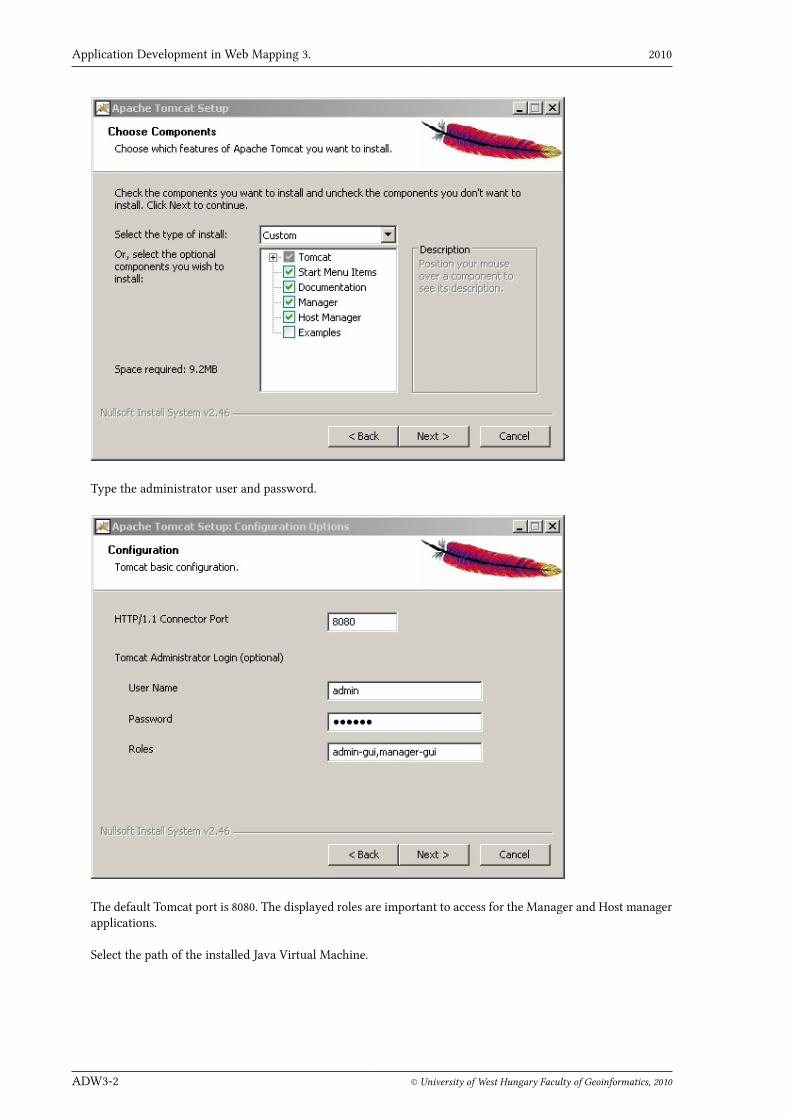
Run the installer and select the Normal installation or the Custom one. Manager is an important administrativetool to deploy applications. Host manager is for manage virtual hosts.
1 OGC compliant softwares and services: http://www.opengeospatial.org/resource/products
Application Development in Web Mapping 3. 2010
ADW3-2 © University of West Hungary Faculty of Geoinformatics, 2010
Type the administrator user and password.
The default Tomcat port is 8080. The displayed roles are important to access for the Manager and Host managerapplications.
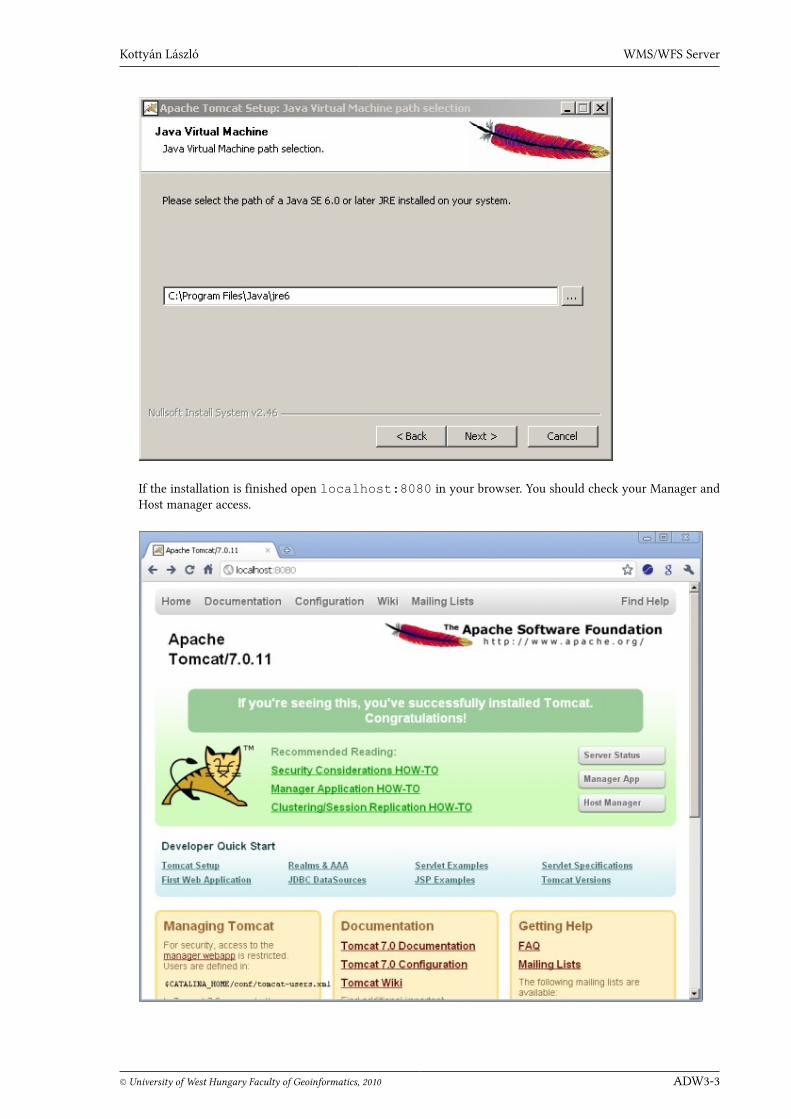
Select the path of the installed Java Virtual Machine.
Kottyán László WMS/WFS Server
© University of West Hungary Faculty of Geoinformatics, 2010 ADW3-3
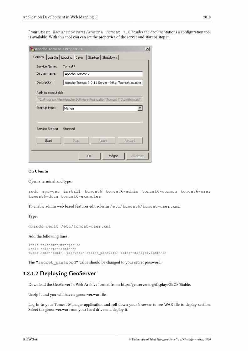
If the installation is finished open localhost:8080 in your browser. You should check your Manager andHost manager access.
Application Development in Web Mapping 3. 2010
ADW3-4 © University of West Hungary Faculty of Geoinformatics, 2010
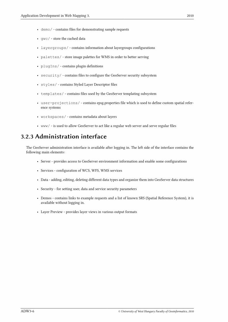
From Start menu/Programs/Apache Tomcat 7.0 besides the documentations a configuration toolis available. With this tool you can set the properties of the server and start or stop it.
On Ubuntu
Open a terminal and type:
sudo apt-get install tomcat6 tomcat6-admin tomcat6-common tomcat6-usertomcat6-docs tomcat6-examples
To enable admin web based features edit roles in /etc/tomcat6/tomcat-user.xml
Type:
gksudo gedit /etc/tomcat-user.xml
Add the following lines:
<role rolename="manager"/><role rolename="admin"/><user name="admin" password="secret_password" roles="manager,admin"/>
The "secret_password" value should be changed to your secret password.
3.2.1.2 Deploying GeoServer
Download the GeoServer in Web Archive format from: http://geoserver.org/display/GEOS/Stable.
Unzip it and you will have a geoserver.war file.
Log in to your Tomcat Manager application and roll down your browser to see WAR file to deploy section.Select the geoserver.war from your hard drive and deploy it.

Kottyán László WMS/WFS Server
© University of West Hungary Faculty of Geoinformatics, 2010 ADW3-5
Open http://localhost:8080/geoserver and you should see the Welcome page of GeoServer.
GeoServer is installed in Tomcat/webapps directory. For example on Windows the path looks like this:
C:\Program Files\Apache Software Foundation\Tomcat 7.0\webapps\geoserver
To log in the administrative area the default settings are:
• username: admin
• password: geoserver
3.2.2 Data DirectoryThe data directory stores all configurations including data sources, services, metadata and more. The data di-rectory path is geoserver/data. On Windows the full path looks like this:
C:\Program Files\Apache Software Foundation\Tomcat 7.0\webapps\geoserv-er\data
The GeoServer data directory has the following structure:
• global.xml - contains general service settings and contact information
• logging.xml - sets the logging parameters
• wms.xml - contains WMS service metadata and settings
• wfs.xml - contains WFS service metadata and settings
• wcs.xml - contains WCS service metadata and settings
• data/ - used to store shp files and raster files
Application Development in Web Mapping 3. 2010
ADW3-6 © University of West Hungary Faculty of Geoinformatics, 2010
• demo/ - contains files for demonstrating sample requests
• gwc/ - store the cached data
• layergroups/ - contains information about layergroups configurations
• palettes/ - store image palettes for WMS in order to better serving
• plugIns/ - contains plugin definitions
• security/ - contains files to configure the GeoServer security subsystem
• styles/ - contains Styled Layer Descriptor files
• templates/ - contains files used by the GeoServer templating subsystem
• user-projections/ - contains epsg.properties file which is used to define custom spatial refer-ence systems
• workspaces/ - contains metadata about layers
• www/ - is used to allow GeoServer to act like a regular web server and serve regular files
3.2.3 Administration interface
The GeoServer administration interface is available after logging in. The left side of the interface contains thefollowing main elements:
• Server - provides access to GeoServer environment information and enable some configurations
• Services - configuration of WCS, WFS, WMS services
• Data - adding, editing, deleting different data types and organize them into GeoServer data structures
• Security - for setting user, data and service security parameters
• Demos - contains links to example requests and a list of known SRS (Spatial Reference System), it isavailable without logging in.
• Layer Preview - provides layer views in various output formats

Kottyán László WMS/WFS Server
© University of West Hungary Faculty of Geoinformatics, 2010 ADW3-7
For more information about administration read the related pages of GeoServer User Manual2.
3.2.4 Data storing
GeoServer manages the following data types:
• Vector data formats
• Shapefiles
• PostGIS databases
• Java Properties files
• Raster data formats
• ArcGrid
• GeoTIFF
• Gtopo302 GeoServer User Manual, Web Administration Interface: http://docs.geoserver.org/stable/en/user/webadmin/index.html
Application Development in Web Mapping 3. 2010
ADW3-8 © University of West Hungary Faculty of Geoinformatics, 2010
• ImageMosaic
• WorldImage
• Other data formats
• External WMS layers
• External WFS layers
Some data types are available through extensions and require additional installation steps:
• ArcSDE
• GML
• DB2
• H2
• MySQL
• Oracle
• Microsoft SQL Server
• Pregeneralized Features
• Vector Product Format
• GDAL program for additional image formats
• Image Pyramid extension for pyramid representation3
• Image Mosaic JDBC
• Oracle Georaster
• Custom JDBC Access for image data
Data configuration requires to set:
• the properties of data (in Layers),
• the location of the data source (in Stores),
• and a namespace4, a logical group of data sets (in Workspaces).
Let's see these configuration options through an example data.
Workspace
Selecting the Workspaces from the left side of administration interface you will get a list of definedworkspaces and there is an add and a remove option on the top.
Clicking on topp workspace the Edit Workspace form is displayed with Name, Namespace URI and DefaultWorkspace properties.

Kottyán László WMS/WFS Server
© University of West Hungary Faculty of Geoinformatics, 2010 ADW3-9
The namespace can be set related to the data provider, data owner, a project or any logical category which issomehow associated to the datasets in the workspace.
Stores
A store is the name for a container of geographic data. A store refers to a specific data source.
Selecting the Stores the given list tells the available stores in the defined workspaces. Each store must beassociated with one workspace.
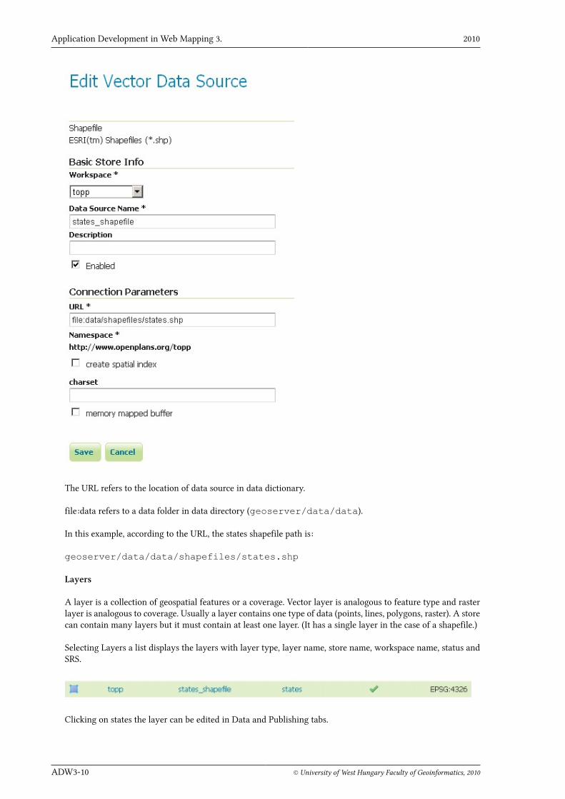
For example topp workspace contains states_shapfile store.
Clicking on states_shapefile an edit form is displayed with Basic Store Info and Connection Parameters.Here the namespace can be modified.
Application Development in Web Mapping 3. 2010
ADW3-10 © University of West Hungary Faculty of Geoinformatics, 2010
The URL refers to the location of data source in data dictionary.
file:data refers to a data folder in data directory (geoserver/data/data).
In this example, according to the URL, the states shapefile path is:
geoserver/data/data/shapefiles/states.shp
Layers
A layer is a collection of geospatial features or a coverage. Vector layer is analogous to feature type and rasterlayer is analogous to coverage. Usually a layer contains one type of data (points, lines, polygons, raster). A storecan contain many layers but it must contain at least one layer. (It has a single layer in the case of a shapefile.)
Selecting Layers a list displays the layers with layer type, layer name, store name, workspace name, status andSRS.
Clicking on states the layer can be edited in Data and Publishing tabs.

Kottyán László WMS/WFS Server
© University of West Hungary Faculty of Geoinformatics, 2010 ADW3-11
• Name - used to reference the layer in WMS requests.
• Title - a human-readable name of the layer for clients.
• Abstract - a description about the layer.
• Keywords - words associated with the layer to aid in catalog searching.
• Metadata links - linked external documents that describe the layer.

Application Development in Web Mapping 3. 2010
ADW3-12 © University of West Hungary Faculty of Geoinformatics, 2010
• Native SRS - the projection of the stored layer
• Declared SRS - the projection what GeoServer gives to clients
• SRS Handling - determines how GeoServer should handle the different projections
• Native Bounding Box - determines the extent of the layer, can be generated
• Lat/Lon Bounding Box - computed bounds based on the standard lat/long, can be generated
• Feature Type Details:
• property and type of data,
• Nillable is true if the value can be empty, null
• how many values allowed to have
Kottyán László WMS/WFS Server
© University of West Hungary Faculty of Geoinformatics, 2010 ADW3-13
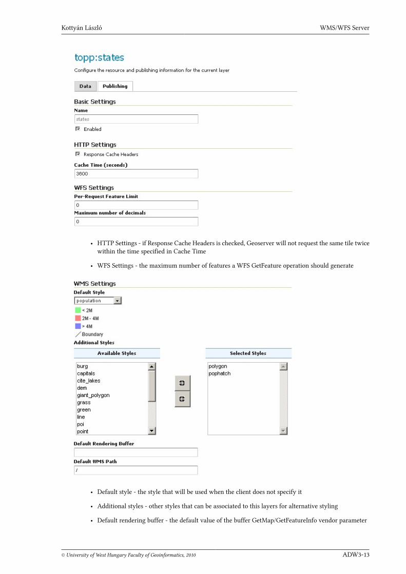
• HTTP Settings - if Response Cache Headers is checked, Geoserver will not request the same tile twicewithin the time specified in Cache Time
• WFS Settings - the maximum number of features a WFS GetFeature operation should generate
• Default style - the style that will be used when the client does not specify it
• Additional styles - other styles that can be associated to this layers for alternative styling
• Default rendering buffer - the default value of the buffer GetMap/GetFeatureInfo vendor parameter
Application Development in Web Mapping 3. 2010
ADW3-14 © University of West Hungary Faculty of Geoinformatics, 2010
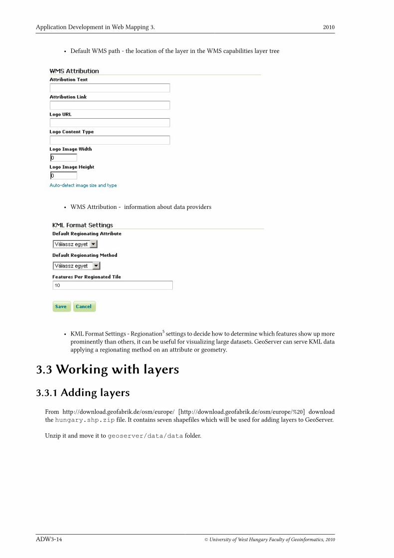
• Default WMS path - the location of the layer in the WMS capabilities layer tree
• WMS Attribution - information about data providers
• KML Format Settings - Regionation5 settings to decide how to determine which features show up moreprominently than others, it can be useful for visualizing large datasets. GeoServer can serve KML dataapplying a regionating method on an attribute or geometry.
3.3 Working with layers
3.3.1 Adding layers
From http://download.geofabrik.de/osm/europe/ [http://download.geofabrik.de/osm/europe/%20] downloadthe hungary.shp.zip file. It contains seven shapefiles which will be used for adding layers to GeoServer.
Unzip it and move it to geoserver/data/data folder.

Kottyán László WMS/WFS Server
© University of West Hungary Faculty of Geoinformatics, 2010 ADW3-15
Create a new workspace, for example:
• Name: AWD
• Namespace URI: http://geo.info.hu/awd
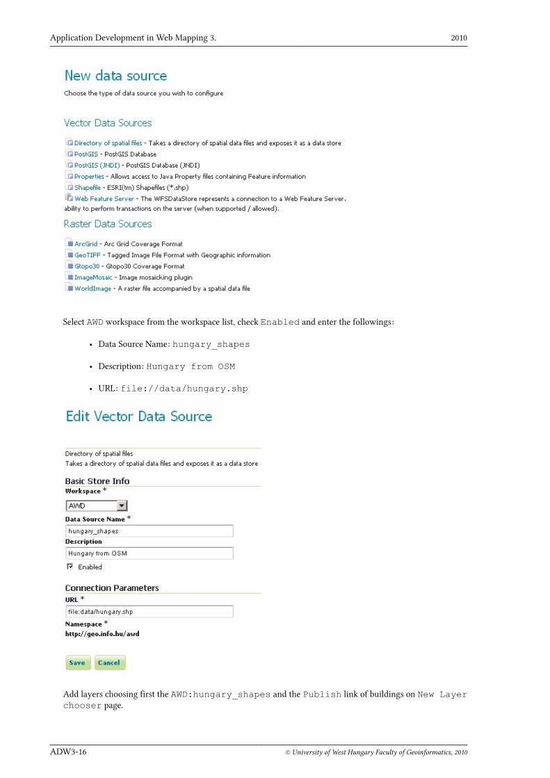
Add a new store, using the Directory of spatial files link. We need this because thehungary.shp contains several shapefiles.
Application Development in Web Mapping 3. 2010
ADW3-16 © University of West Hungary Faculty of Geoinformatics, 2010
Select AWD workspace from the workspace list, check Enabled and enter the followings:
• Data Source Name: hungary_shapes
• Description: Hungary from OSM
• URL: file://data/hungary.shp
Add layers choosing first the AWD:hungary_shapes and the Publish link of buildings on New Layerchooser page.
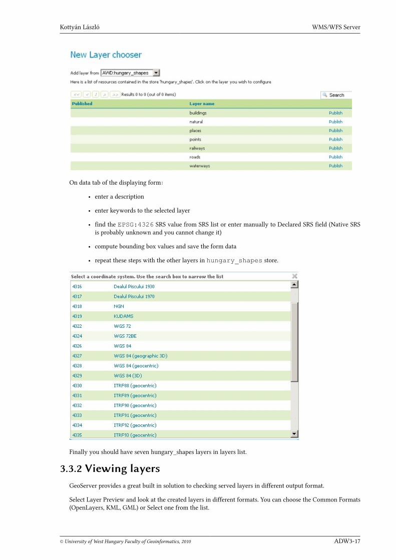
Kottyán László WMS/WFS Server
© University of West Hungary Faculty of Geoinformatics, 2010 ADW3-17
On data tab of the displaying form:
• enter a description
• enter keywords to the selected layer
• find the EPSG:4326 SRS value from SRS list or enter manually to Declared SRS field (Native SRSis probably unknown and you cannot change it)
• compute bounding box values and save the form data
• repeat these steps with the other layers in hungary_shapes store.
Finally you should have seven hungary_shapes layers in layers list.
3.3.2 Viewing layersGeoServer provides a great built in solution to checking served layers in different output format.
Select Layer Preview and look at the created layers in different formats. You can choose the Common Formats(OpenLayers, KML, GML) or Select one from the list.

Application Development in Web Mapping 3. 2010
ADW3-18 © University of West Hungary Faculty of Geoinformatics, 2010
3.3.3 Grouping layers
Creating a group from layers is easy. GeoServer calculate the bounds and provides options to add layers fromany stores and declare the order of them.
Styling can be done with the default style or by selecting an alternate style.
The output with default styles:

Kottyán László WMS/WFS Server
© University of West Hungary Faculty of Geoinformatics, 2010 ADW3-19
Styling in GeoServer is based on Styled Layer Descriptor (SLD) OGC specification. An SLD file can be createdusing the GeoServer built-in editor which provides a validation also. To get more information about styling seeAWD Module 5 or read the User Manual6.
3.4 Web Map ServiceA Web Map Service (WMS) produces maps of spatially referenced data dynamically from geographic informa-tion. WMS-produced maps are generally rendered in PNG, GIF, JPEG, SVG and WebCGM formats.
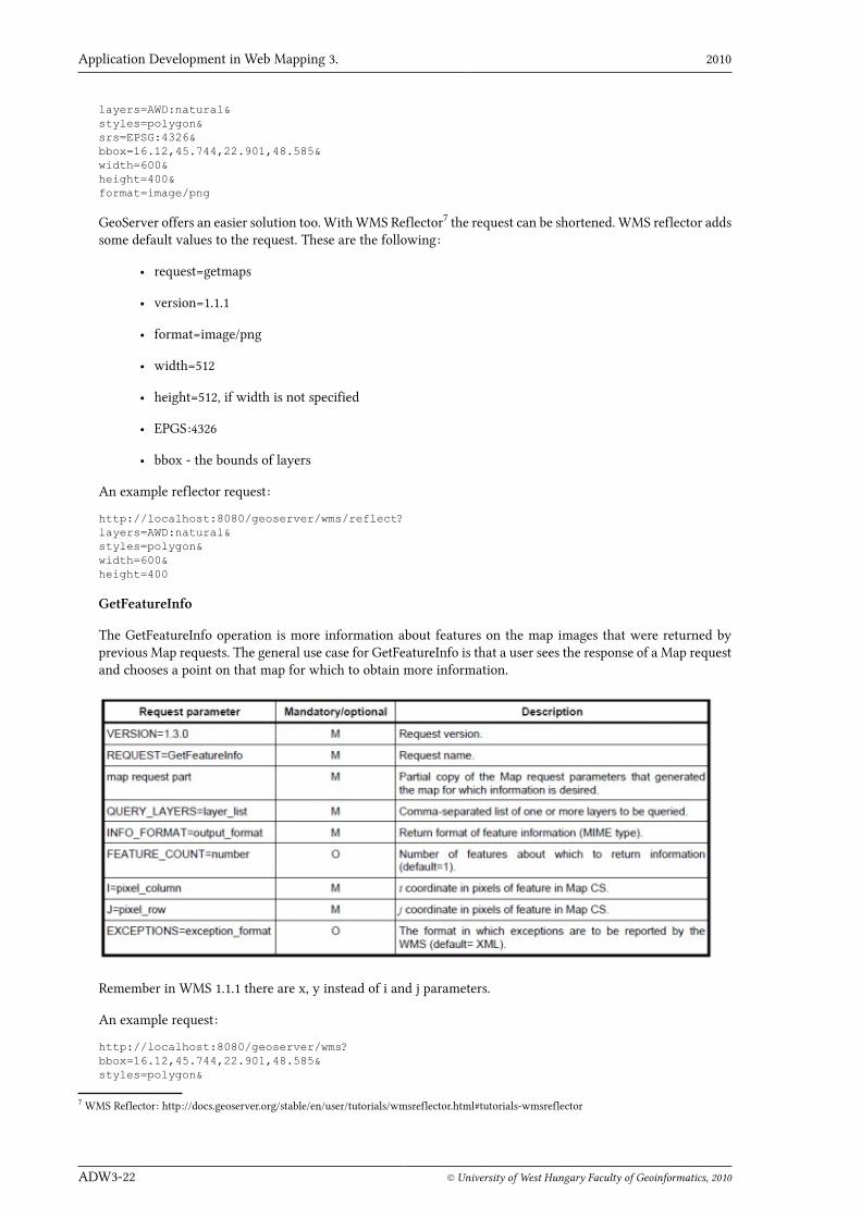
To work with maps, the standard defines three operations:
• GetCapabilities
• GetMap
• GetFeatureInfo
This operations used in HTTP is requested by clients. Each operation produces a response in a particular format.WMS server which supports SLD (Styled Layer Descriptor) generally has DescribeLayer and GetLegendGraphicoperations.
A HTTP GET request is an URL which has a query part after the ? character. The query has parameters separatedwith & sign. The parameters are given with name and value separated with = sign. Here is an example:
http://www.example.com/myserver?param1=value1¶m2=value2
GeoServer supports both WMS 1.1.1 and 1.0.3 standards. In GetMap request the srs parameter from 1.1.1 in 1.0.3is changed to crs. The axis ordering from longitude/latitude or x/y in 1.1.1 in 1.0.3 is changed to latitude/longitudeor y/x.
In GetFeatureInfo request the x, y parameters from 1.1.1 in 1.0.3 is changed to i, j.
GetCapabilities
This operation is used to get information about what operations and services are offered by a server. The Get-Capabilities parameters are:
6 GeoServer User Manual, Styling section: http://docs.geoserver.org/stable/en/user/styling/index.html

Application Development in Web Mapping 3. 2010
ADW3-20 © University of West Hungary Faculty of Geoinformatics, 2010
Let's get the capabilities of the local GeoServer. Make sure that your server is running, open a browser windowand paste:
http://localhost:8080/geoserver/wms?service=wms&request=GetCapabilities
Notes:
• The request in GeoServer works without the service parameters too.
• In GeoServer the deafult route of WMS is /geoserver/wms and the route of WFS is /geoserv-er/wfs.
The response is an XML document. It can be opened in an editor or Web browser. The first part of it is in <Ser-vice> tag the second part is in <Capability> tag. The Service contains information about the WMS service andthe service contact who is responsible for the service. These information can be configured on Administrationinterface Server/Contact Information and Services/WMS pages.
The Capability contains metadata about map formats, layers, legends, SRSs.
Here is a part of the XML document that describes the natural layer from hungary_shapes:
<Layer queryable="1"> <Name>AWD:natural</Name> <Title>natural</Title> <Abstract/> <KeywordList/> <SRS>EPSG:4326</SRS> <LatLonBoundingBox minx="16.12" miny="45.744" maxx="22.901" maxy="48.585"/> <BoundingBox SRS="EPSG:4326" minx="16.12" miny="45.744" maxx="22.901" maxy="48.585"/> <Style> <Name>polygon</Name> <Title>Default Polygon</Title> <Abstract>A sample style that draws a polygon</Abstract> <LegendURL width="20" height="20"> <Format>image/png</Format> <OnlineResourcexmlns:xlink="http://www.w3.org/1999/xlink" xlink:type="simple" xlink:href="http://localhost:8080/geoserver/wms?request=GetLegendGraphic&format=image%2Fpng&width=20&height=20&layer=natural"/> </LegendURL> </Style></Layer>
GetMap
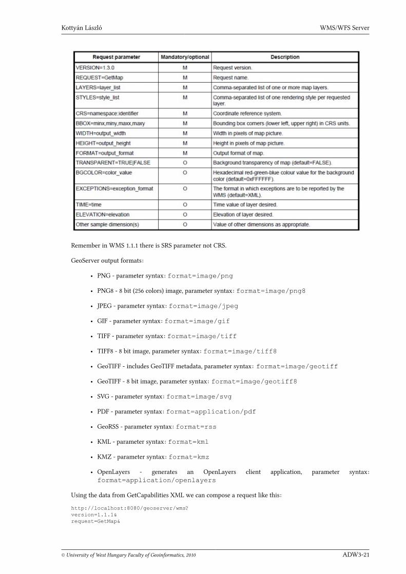
The GetMap request parameters are:
Kottyán László WMS/WFS Server
© University of West Hungary Faculty of Geoinformatics, 2010 ADW3-21
Remember in WMS 1.1.1 there is SRS parameter not CRS.
GeoServer output formats:
• PNG - parameter syntax: format=image/png
• PNG8 - 8 bit (256 colors) image, parameter syntax: format=image/png8
• JPEG - parameter syntax: format=image/jpeg
• GIF - parameter syntax: format=image/gif
• TIFF - parameter syntax: format=image/tiff
• TIFF8 - 8 bit image, parameter syntax: format=image/tiff8
• GeoTIFF - includes GeoTIFF metadata, parameter syntax: format=image/geotiff
• GeoTIFF - 8 bit image, parameter syntax: format=image/geotiff8
• SVG - parameter syntax: format=image/svg
• PDF - parameter syntax: format=application/pdf
• GeoRSS - parameter syntax: format=rss
• KML - parameter syntax: format=kml
• KMZ - parameter syntax: format=kmz
• OpenLayers - generates an OpenLayers client application, parameter syntax:format=application/openlayers
Using the data from GetCapabilities XML we can compose a request like this:
http://localhost:8080/geoserver/wms?version=1.1.1&request=GetMap&
Application Development in Web Mapping 3. 2010
ADW3-22 © University of West Hungary Faculty of Geoinformatics, 2010
layers=AWD:natural&styles=polygon&srs=EPSG:4326&bbox=16.12,45.744,22.901,48.585&width=600&height=400&format=image/png
GeoServer offers an easier solution too. With WMS Reflector7 the request can be shortened. WMS reflector addssome default values to the request. These are the following:
• request=getmaps
• version=1.1.1
• format=image/png
• width=512
• height=512, if width is not specified
• EPGS:4326
• bbox - the bounds of layers
An example reflector request:
http://localhost:8080/geoserver/wms/reflect?layers=AWD:natural&styles=polygon&width=600&height=400
GetFeatureInfo
The GetFeatureInfo operation is more information about features on the map images that were returned byprevious Map requests. The general use case for GetFeatureInfo is that a user sees the response of a Map requestand chooses a point on that map for which to obtain more information.
Remember in WMS 1.1.1 there are x, y instead of i and j parameters.
An example request:
http://localhost:8080/geoserver/wms?bbox=16.12,45.744,22.901,48.585&styles=polygon&
7 WMS Reflector: http://docs.geoserver.org/stable/en/user/tutorials/wmsreflector.html#tutorials-wmsreflector

Kottyán László WMS/WFS Server
© University of West Hungary Faculty of Geoinformatics, 2010 ADW3-23
format=png&info_format=text/plain&request=GetFeatureInfo&layers=AWD:natural&query_layers=AWD:natural&width=600&height=400&x=170&y=160
The result is a text document with feature information.
Read more about WMS in the specification document8 or on the related pages of GeoServer User Manual9.
3.5 Web Feature ServiceThe Web Feature Service (WFS) is a standard to send and receive geospatial data through HTTP. WFS transfersinformation in Geographic Markup Language (GML) format. GML is an OGC standard10 to express geographicdata in XML.
WFS operations are:
• GetCapabilities
• DescribeFeatureType
• GetFeature
• LockFeature
• Transaction
• GetGMLObject (in WFS 1.1.0 only)
Transactions can contain INSERT, UPDATE or DELETE elements to add, modify or remove features.
GeoServer supports WFS 1.0.0 and 1.1.0 standards.
GetCapabilities
The GetCapabilities request gives an XML document with metadata of service, operations, feature types, func-tions (spatial, logical, arithmetic) which are provided by a server.
Insert the next request into your browser and study the result xml:
http://localhost:8080/geoserver/wfs?service=wfs&version=1.1.0&request=GetCapabilities
DescribeFeatureType
DescribeFeatureType returns an XML schema document describing the
structure of the data set. The schema document lists each field and its
data type.
http://localhost:8080/geoserver/wfs?service=WFS&version=1.1.0&request=DescribeFeatureType&
8 OGC WMS standard: http://www.opengeospatial.org/standards/wms9 GeoServer User Manual, Web Map Service: http://docs.geoserver.org/stable/en/user/services/wms/index.html10 OGC GML standard: http://www.opengeospatial.org/standards/gml

Application Development in Web Mapping 3. 2010
ADW3-24 © University of West Hungary Faculty of Geoinformatics, 2010
typeName=AWD:railways
The result is an XML document.
GetFeature
To get the geospatial data we can use the GetFeature request.
http://localhost:8080/geoserver/wfs?service=WFS&version=1.1.0&request=GetFeature&typeName=AWD:railways
The result is a GML document.
Read more about WFS in the specification document11 or on the related pages of GeoServer User Manual12.
To study some example requests, open your server Demos page and select Demo requests link.
BibliographyGeoServer: GeoServer User Manual, 2011, http://docs.geoserver.org/stable/en/user/
Scott, D.: GIS for Web developers, Adding Where to Your Web Applications, The Pragmatic Programmers LLC, 2007
11 OGC WFS standard: http://www.opengeospatial.org/standards/wfs12 GeoServer User Manual, Web Feature Service: http://docs.geoserver.org/stable/en/user/services/wfs/index.html