application for a development permit for material …
TRANSCRIPT

APPLICATION FOR A DEVELOPMENT PERMIT FOR MATERIAL CHANGE OF USE FOR MEDIUM IMPACT INDUSTRY (WATER BOTTLING FACILITY) on land located at L10 UPPER DAINTREE ROAD, UPPER DAINTREE described as LOT 10 ON SP304851 for JP & VE NOLI

CONTENTS
1.0 INTRODUCTION .......................................................................................................... 1
1.1 SUMMARY OF APPLICATION
2.0 THE SITE ...................................................................................................................... 2
2.1 SITE DESCRIPTION
2.2 SITE CHARACTERISTICS & SURROUNDING AREA
2.3 PRE-LODGEMENT MEETING
3.0 PROPOSED DEVELOPMENT .......................................................................................... 4
4.0 LEGISLATIVE FRAMEWORK ........................................................................................... 5
4.1 PLANNING ACT 2016 CONSIDERATIONS
4.1 REFERRAL AGENCIES
5.0 THE PLANNING FRAMEWORK ....................................................................................... 6
5.1 DEFINED LAND USE UNDER DOUGLAS SHIRE PLANNING SCHEME
5.2 APPLICABLE DOUGLAS SHIRE PLANNING SCHEME PROVISIONS
& LEVEL OF ASSESSMENT
5.3 ASSESSMENT AGAINST APPLICABLE CODES
6.0 CONCLUSION ........................................................................................................... 13

APPENDICES
Appendix A: DA Form 1 and Land Owners Consent Appendix B: Title Search Appendix C: Plans of Proposed Development
FIGURES
Figure 1: Satellite Imagery of the subject land (source Queensland Globe September
2019) Figure 2: Satellite Imagery of the subject land with contour levels (source Queensland
Globe September 2019)

Daintree Water Bottling Facility Page 1 34863-001-01 26 September 2019
1.0 INTRODUCTION This report has been prepared on behalf of the Applicant, JP and VE Noli. The Applicant is seeking approval from Douglas Shire Council for a Material Change of Use for Medium Impact Industry (Water Bottling Facility) on land located at Upper Daintree Road, Upper Daintree and properly described as Lot 10 on SP304851. This development application addresses all relevant assessment provisions pursuant to section 51 of the Planning Act 2016. The report includes a review of the sites characteristics, addresses the merits of the development with regard to the provisions of the Douglas Shire Planning Scheme and evaluates the town planning issues associated with the proposed development. The facts and circumstances relied upon in the preparation of this report are current and relevant as at September 2019.
1.1 SUMMARY OF APPLICATION Details of the application are summarised in the table below:
Location and Property Description
Upper Daintree Road, Upper Daintree Lot 10 on SP304851
Proposal Material Change of Use for Medium Impact Industry (Water Bottling Facility)
Planning Scheme Douglas Shire Planning Scheme
Level of Assessment Impact Assessable
Referral Agencies Nil
Mandatory forms, including DA Form 1 is included at Appendix A of this report. Land owners consent from James Paul Noli and Valmae Evelyn Noli to the making of this application is also included at Appendix A.
Daintree Water Bottling Facility Page 2 34863-001-01 26 September 2019
2.0 THE SITE 2.1 SITE DESCRIPTION
The land subject to this application is summarised in the following table:
Site Address Upper Daintree Road, Upper Daintree
Property Description
Lot 10 on SP304851
Site Area 74.87 hectares
Encumbrances Easement D on RP25790 and Easement E on RP726174 – benefitting Douglas Shire Council
Registered Land Owner
James Paul Noli and Valmae Evelyn Noli
The current Title Search confirming the abovementioned is included at Appendix B of this report. A Smart Map is also included at Appendix B to show the existing configuration of the subject land.
2.2 SITE CHARACTERISTICS & SURROUNDING AREA
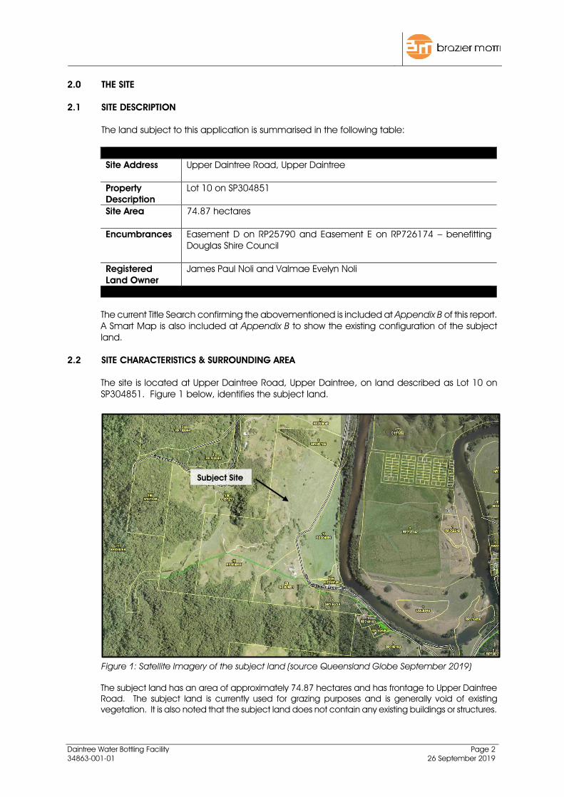
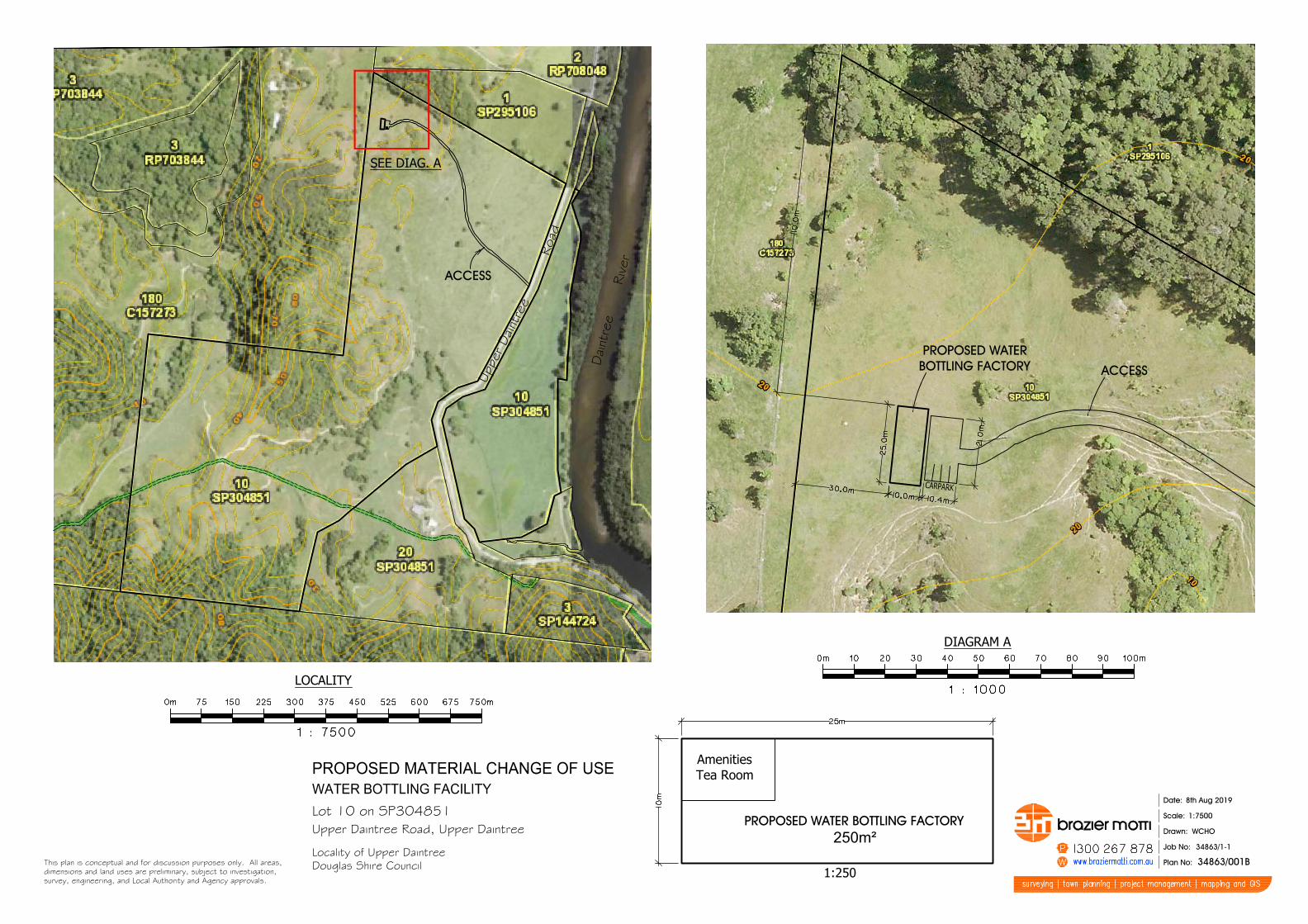
The site is located at Upper Daintree Road, Upper Daintree, on land described as Lot 10 on SP304851. Figure 1 below, identifies the subject land. Figure 1: Satellite Imagery of the subject land (source Queensland Globe September 2019) The subject land has an area of approximately 74.87 hectares and has frontage to Upper Daintree Road. The subject land is currently used for grazing purposes and is generally void of existing vegetation. It is also noted that the subject land does not contain any existing buildings or structures.
Subject Site

Daintree Water Bottling Facility Page 3 34863-001-01 26 September 2019
The front of the subject land is reasonably flat, however, the topography of the site increases in grade in the western parts of the site. Figure 2 below shows the contour levels of the subject land. Figure 2: Satellite Imagery of the subject land with contour levels (source Queensland Globe September 2019) On a wider perspective, the subject land is located approximately 1.7 kilometres (as the crow flies) west from the Daintree Village township. The land is generally surrounded by large rural holdings. The Daintree River is located approximately 150 metres east of the site.
2.3 PRE-LODGEMENT MEETING A pre-lodgement meeting was undertaken with Douglas Shire Council on Wednesday 21st August 2019. The meeting was attended by Neil Beck from Douglas Shire Council, the Applicant, as well as the Applicants planning consultant, Brazier Motti Pty Ltd. It was indicated that Council were generally supportive of the proposed establishment of the Water Bottling Facility, however, there would need to be further investigations undertaken, particularly in relation to the water being obtained from the intake and traffic.

Daintree Water Bottling Facility Page 4 34863-001-01 26 September 2019
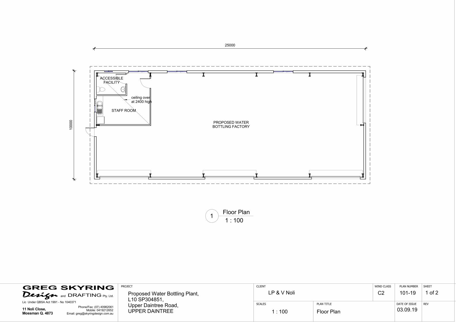
3.0 PROPOSED DEVELOPMENT This Development Application seeks approval from Douglas Shire Council for an application for a Material Change of Use Medium Impact Industry (Water Bottling Facility) on land located at Upper Daintree Road, Upper Daintree and properly described as Lot 10 on SP304851. The Applicant is proposing to ‘tap’ into Council’s existing water supply, located on Lot 80 on SP224299. The water will be gravity fed to a 10,000 litre holding tank and then piped (gravity) to the water bottling facility, where the water is filtered and treated and then bottled. It is intended to ‘bottle’ the water in BPA-free paperboard packaging, which are eco-friendly and sustainable, compared to plastic bottles. The biodegradable cartons come flat-packed and will be formed, filled and sealed by specialist equipment within the Water Bottling Facility building on site. Once the cartons are filled and ready they will be packaged and transported to the off-site storage facility, ready for distribution. It is understood that the water allocation from Douglas Shire Council is a maximum of 10,000 litres of water per day. Accordingly, it is intended that output from the Water Bottling Facility may be in the order of 20,000 500ml cartons of water per day. The proposed Water Bottling Facility building is a single storey building and has a total floor area of approximately 250m². The building will contain the water filtration and treatment system, as well as the specialist carton forming, filling and sealing equipment. It is noted that the building will provide amenities and a staff room. The proposed building is located in the north western part of the site, being setback approximately 30 metres from the western boundary and approximately 110 metres from the northern boundary. An access driveway from Upper Daintree Road will provide vehicle access to the Water Bottling Facility building. As mentioned, once filled, the cartons will be packaged and transported to the off-site storage facility, ready for distribution. It is intended to only have one truck (body truck) movement to and from the site per day. In addition to the truck movements, the only other vehicle movements will be the staff’s vehicles. On site car parking and manoeuvring area is provided on site, in front of the Water Bottling Facility building. As identified on the Site Plan, it is proposed to provide four (4) dedicated car parking spaces on site. The operation will employ two (2) staff and will operate within usual business hours. Plans of development, including a Site Plan and a floor plan and elevations of the Water bottling facility building are included at Appendix C.

Daintree Water Bottling Facility Page 5 34863-001-01 26 September 2019
4.0 LEGISLATIVE FRAMEWORK 4.1 PLANNING ACT 2016 CONSIDERATIONS
The purpose of the Planning Act 2016 (PA) is to “establish an efficient, effective, transparent, integrated, coordinated, and accountable system of land use planning, development assessment and related matters that facilitates the achievement of ecological sustainability”. This section provides an overview of the legislative context of the development application under the provisions of the Planning Act 2016. Assessable Development
The proposed development constitutes assessable development under the Douglas Shire Planning Scheme. Accordingly, pursuant to Section 44(3) of the Planning Act 2016 a development approval is required.
Assessment Manager
Pursuant to Schedule 8 of the Planning Regulation 2017 the Assessment Manager for this development application is Douglas Shire Council.
Level of Assessment
The Douglas Shire Planning Scheme identifies that the proposed development is Impact Assessable.
Public Notification
The application is Impact Assessable, therefore, in accordance with section 53 of the Planning Act 2016 public notification is required. In accordance with section 53(4) of the Planning Act 2016 Public Notification will be undertaken for 15 business days.
4.1 REFERRAL AGENCIES
Schedule 10 of the Planning Regulation 2017 outlines the triggers for the referral of the development application to other agencies. A review of the Development Assessment Mapping System (DAMS) and other matters has confirmed that the proposed development does not trigger referral under Schedule 10 of the Planning Regulation 2017.

Daintree Water Bottling Facility Page 6 34863-001-01 26 September 2019
5.0 THE PLANNING FRAMEWORK The Douglas Shire Planning Scheme is the current planning scheme for the Douglas region. The planning scheme commenced on and from 2 January 2018. The Douglas Shire Planning Scheme sets a clear direction for future development and sustainable growth. The following sections of this report provide an assessment of the proposed development against the relevant provisions of the Planning Scheme.
5.1 DEFINED LAND USE UNDER DOUGLAS SHIRE PLANNING SCHEME Under the Douglas Shire Planning Scheme the proposed development is defined as Medium Impact Industry. Schedule 1 of the planning scheme provides the following definition for Medium Impact Industry:
Premises used for industrial activities that include the manufacturing, producing, processing, repairing, altering, recycling, storing, distributing, transferring or treating of products and have one or more of the following attributes:
potential for noticeable impacts on sensitive land uses due to offsite emissions including aerosol, fume, particle, smoke, odour and noise;
potential for noticeable offsite impacts in the event of fire, explosion or toxic release;
generates high traffic flows in the context of the locality or the road network; generates an elevated demand on the local infrastructure network;
onsite controls are required for emissions and dangerous goods risks; the use is primarily undertaken indoors; evening or night activities are undertaken indoors and not outdoors.
Examples of Medium Impact Industry land uses include:
Spray painting and surface coating, wooden and laminated product manufacturing (including cabinet making, joining, timber truss making or wood working).
Additional examples and thresholds for industry uses are provided at SC 1.1.2 of Schedule 1 of the Douglas Shire Planning Scheme. Specifically, the following is provided as an example of Medium Impact Industry:
Processing, smoking, drying, curing, milling, bottling or canning food, beverages or pet food, less than 200 tonnes per annum
5.2 APPLICABLE DOUGLAS SHIRE PLANNING SCHEME PROVISIONS & LEVEL OF ASSESSMENT
The table below provides an overview of the planning scheme applicable to the subject land and the proposed development provisions under the Douglas Shire Planning Scheme:
Zone Rural Zone
Local Plan Not Applicable
Overlays Acid Sulfate Soils Overlay (Land above 5m AHD and below 20m AHD)
Flood and Storm Tide Inundation Overlay (100 Year ARI)
Landscape Values (Medium Landscape Value)

Daintree Water Bottling Facility Page 7 34863-001-01 26 September 2019
Natural Areas Overlay (MSES – Regulated Vegetation (Of Concern Regional Ecosystem) and MSES – Regulated Vegetation (Intersecting a Watercourse)
Transport Network Overlay (Adjoining Major Rural Road)
The Assessment Table for the Rural Zone identifies an application for a Material Change of Use for Medium Impact Industry is Impact Assessable. While the Table of Assessment for the Rural Zone identifies that the proposed development requires assessment against the entire planning scheme, it is considered appropriate to specifically assess the proposed development against the following planning scheme codes:
Applicable Codes
Zone Code Rural Zone Code
Overlay Codes Acid Sulfate Soils Overlay Code Flood and Storm Tide Inundation Overlay Code
Landscape Values Overlay Code Natural Areas Overlay Code
Transport Network Overlay Code
Development Codes Industry Activities Code
Access, Parking and Servicing Code Environmental Performance Code Infrastructure Works Code
Landscaping Code
5.3 ASSESSMENT AGAINST APPLICABLE CODES
Under the Douglas Shire Planning Scheme, codes set out the performance requirements to be satisfied by development. An assessment against the applicable Planning Scheme Codes is as follows: 5.3.1 Assessment Against Zone Code Rural Zone Code
The subject land is wholly contained within the Rural Zone. Generally, land within the Rural Zone should provide for rural uses including cropping, intensive horticulture, intensive animal industries, animal husbandry, animal keeping, extractive industries and other primary production activities. The proposed Water Bottling Facility building is a single storey building and has a total floor area of approximately 250m². The proposed building is located in the north western part of the site, being setback approximately 30 metres from the western boundary and approximately 110 metres from the northern boundary. From the Upper Daintree Road frontage the proposed building is setback in excess of 450 metres. An access driveway from Upper Daintree Road will provide vehicle access to the Water Bottling Facility building. It is acknowledged that the proposed development does not represent a rural development or activity and is identified as an inconsistent land use, however, the Water Bottling Facility is dependent on being established in this location (i.e. where the

Daintree Water Bottling Facility Page 8 34863-001-01 26 September 2019
water supply is). The proposed infrastructure associated with the Water Bottling Facility is low impact and is no different to infrastructure which could be established for a rural industry. It is also noted that, while the proposed development is defined as Medium Impact Industry, the nature of the proposed land use is very low impact and not industrial. The location, scale, design and height of the proposed development is compatible with the landscape values of the locality and is in keeping with the amenity of adjoining premises and the rural character of the area and will be located to achieve adequate from neighbouring properties and the road frontage. Furthermore, due to the nature of the proposed land use, it is considered that the proposed development is appropriately located and the broader rural landscape will not be impacted on from the establishment of the proposed Medium Impact Industry (Water Bottling Facility) in this location. Overall, it is considered that the proposed development is generally consistent with the outcomes identified in the planning scheme for the Rural Zone. Furthermore, it is considered that there are sufficient grounds to support the proposed development at this location as it will not adversely affect the character or amenity of the locality or the zone.
5.3.2 Assessment Against Overlay Codes
Acid Sulfate Soils Overlay Code The overlay mapping identifies the natural ground level of the site being above five (5) metres AHD but below 20 metres AHD. Accordingly, assessment against the Acid Sulfate Soils Overlay Code is applicable. The proposed development does not involve any major excavation or filling other than minor earthworks to prepare the slab for the proposed shed. Accordingly, the disturbance of material potentially containing acid sulfate soils will be avoided. Overall, it is considered that the proposed development achieves general consistency with the applicable Acceptable Outcomes and Performance Outcomes of the Acid Sulfate Soils Overlay Code. Flood Inundation and Hazard Overlay Code The overlay mapping identifies that part of the subject land is within the 100 year ARI flood inundation area. Accordingly, assessment against the Flood and Storm Tide Inundation Overlay Code is applicable. While the site is identified as being partly within the 100 year ARI flood inundation area, the building associated with the proposed Water Bottling Facility will be located outside of the inundation area. Therefore, As the building is sited outside of the flood inundation area, it is considered that the development is located and designed to ensure the safety of all persons and minimise the possibility of any damage to the development. It is also noted that as the proposed development does not involve any alteration to the nature of the site, accordingly, there should not be any adverse impacts from flood inundation on adjoining properties. Overall, it is considered that the proposed development achieves general consistency with the applicable Acceptable Outcomes and Performance Outcomes of the Flood and Storm Tide Inundation Overlay Code.

Daintree Water Bottling Facility Page 9 34863-001-01 26 September 2019
Landscape Values Overlay Code The overlay mapping identifies that that part of the subject land where the proposed development is located has Medium Landscape Values. Accordingly, assessment against the Landscape Values Overlay Code is applicable. The subject land is currently used for grazing purposes and is therefore, generally void of significant landscape elements and features. The proposed Water Bottling Facility is a relatively low impact development, in that it consists of a single storey building, located in the north eastern corner of the site, approximately 500 metres from the Upper Daintree Road frontage. The proposed Water Bottling Facility building is no different to a shed for rural industry, which could be established on the site. Accordingly, it is considered that the location, scale, design and height of the proposed development is compatible with the landscape values of the locality. Overall, it is considered that the proposed development achieves general consistency with the applicable Acceptable Outcomes and Performance Outcomes of the Landscape Values Overlay Code. Natural Areas Overlay Code The overlay mapping identifies that the subject land contains MSES – Regulated Vegetation (Of Concern Regional Ecosystem) and MSES – Regulated Vegetation (Intersecting a Watercourse). Accordingly, assessment against the Natural Areas Overlay Code is applicable. The subject land is currently used for grazing purposes and is therefore, generally void of any matters of environmental significance. The proposed Water Bottling Facility building and associated access have been appropriately sited to ensure that adverse impacts on any matters of environmental significance and natural areas are avoided. Overall, it is considered that the proposed development achieves general consistency with the applicable Acceptable Outcomes and Performance Outcomes of the Natural Areas Overlay Code. Transport Network Overlay Code The subject land has direct road frontage to Upper Daintree Road, which is identified as a Major Rural Road. Accordingly, assessment against the Transport Network Code is applicable. The purpose of the Transport network overlay code is to ensure that development provides transport infrastructure that supports a safe, efficient transport network, including the active transport network. An access driveway from Upper Daintree Road will provide vehicle access to the Water Bottling Facility building. As mentioned, once filled the cartons will be packaged and transported to the off-site storage facility, ready for distribution. It is intended to only have one (1) truck (body truck) movement to and from the site per day. In addition to the truck movements, the only other vehicle movements will be the staff’s vehicles. It is considered that the access point will operate safely and efficiently and will appropriately accommodate the anticipated type and volume of vehicles accessing the site.

Daintree Water Bottling Facility Page 10 34863-001-01 26 September 2019
It is acknowledged that the truck will have to travel through the Daintree Village township, however, given that it will be one (1) movement to and from the site per day, it is considered that this will not result in adverse impacts on the residential area. Overall, it is considered that the proposed development achieves general consistency with the applicable Acceptable Outcomes and Performance Outcomes of the Transport Network Overlay Code.
5.3.3 Assessment Against Development Codes
Industry Activities Code The purpose of the Industry Activities Code is to ensure that:
the scale, character and built form of development contributes to a high standard of amenity;
the design incorporates facilities and features that contribute to a high standard environment for workers and customers; and
the development has access to development infrastructure, including utility installations and essential services.
The proposed Water Bottling Facility building is a single storey building and has a total floor area of approximately 250m², which is a site coverage of less than 1%. The proposed building is located in the north western part of the site, being setback approximately 30 metres from the western boundary and approximately 110 metres from the northern boundary. From the Upper Daintree Road frontage the proposed building is setback in excess of 450 metres. The building will contain the water filtration and treatment system, as well as the specialist carton forming, filling and sealing equipment. In addition, the building will provide amenities and a staff room. An access driveway from Upper Daintree Road will provide vehicle access to the Water Bottling Facility building. As identified on the Site Plan it is proposed to provide a total of four (4) on-site parking spaces and sufficient manoeuvring area for all vehicles entering and existing the premises. All on-site vehicle parking spaces and manoeuvring areas will be designed and constructed in accordance with relevant standards, including parking bay dimensions, aisle widths, speed control grades, vehicle turn-arounds etc. Given the location, scale, design and height of the proposed development is considered that the development is compatible with the landscape values of the locality and will not require substantial landscaping to be provided. However, if any landscaping is required as part of the proposed development, it will be designed and planned in accordance with the planning scheme requirements. Overall it is considered that the proposed development is of a scale, character and built form of development contributes to a high standard of amenity. Furthermore, the proposed Water Bottling Facility achieves consistency with the applicable Acceptable Outcomes and Performance Outcomes of the Industry Activities Code. Access, Parking and Servicing Code The Access, Parking and Servicing Code seeks to ensure that parking and access infrastructure and facilities are provided to service the demand of the development. The Access, Parking and Servicing Code states that for a Medium Impact Industry land use, vehicle parking must be provided at a rate of one (1) space per 90m² of Gross Floor Area (GFA).
Daintree Water Bottling Facility Page 11 34863-001-01 26 September 2019
Accordingly, based on a GFA of 250m² for the Water Bottling Facility building, a total of 2.7 car parking spaces should be provided. As identified on the Site Plan it is proposed to provide a total of four (4) on-site parking spaces. Accordingly, the proposed development complies with the car parking requirements prescribed. All on-site vehicle parking spaces and manoeuvring areas will be designed and constructed in accordance with relevant standards, including parking bay dimensions, aisle widths, speed control grades, vehicle turn-arounds etc. An access driveway from Upper Daintree Road will provide vehicle access to the Water Bottling Facility building and the on-site car parking area. As previously mentioned, it is considered that the access point will operate safely and efficiently and will appropriately accommodate the anticipated type and volume of vehicles accessing the site. Overall it is considered that the proposed development achieves consistency with the applicable Acceptable Outcomes and Performance Outcomes of the Access, Parking and Servicing Code. Environmental Performance Code The Environmental Performance Code seeks to ensure that development is designed and operated to avoid or mitigate impacts on sensitive receiving environments. The development itself does not have the potential to cause any adverse impacts on the amenity of adjacent and surrounding land. It is expected that conditions will be imposed in relation stormwater drainage, stormwater quality, soil and erosion sediment control to ensure that there are no adverse impacts as a result of the proposed development. Overall it is considered that the proposed development achieves consistency with the applicable acceptable outcomes and performance outcomes of the Environmental Performance Code. Infrastructure Works Code The Infrastructure Works Code seeks to ensure that development provides infrastructure designed and constructed to meet the needs of development are area safe and efficient. The building will contain the water filtration and treatment system, as well as the specialist carton forming, filling and sealing equipment. In addition, the building will provide amenities and a staff room. Connections to any required infrastructure services will be undertaken in accordance with the specifications of the FNQROC Development Manual. Conditions of approval requiring connections to the required infrastructure services are expected. As previously mentioned vehicular access to the proposed development will be via the access point on the Upper Daintree Road. An access driveway from Upper Daintree Road will provide vehicle access to the Water Bottling Facility building and the on-site car parking area. As previously mentioned, it is considered that the access point will operate safely and efficiently and will appropriately accommodate the anticipated type and volume of vehicles accessing the site. Overall it is considered that the proposed development achieves consistency with the applicable Acceptable Outcomes and Performance Outcomes of the Infrastructure Works Code.

Daintree Water Bottling Facility Page 12 34863-001-01 26 September 2019
Landscaping Code The Landscaping Code seeks to ensure that landscaping is provided to enhance the tropical amenity and character of the region. If any landscaping is required as part of the proposed development, it will be designed and planned in accordance with the planning scheme requirements. Overall it is considered that the proposed development achieves consistency with the applicable acceptable outcomes and performance outcomes of the Landscaping Code.
Daintree Water Bottling Facility Page 13 34863-001-01 26 September 2019
6.0 CONCLUSION
This report has been prepared on behalf of the Applicant, JP and VE Noli in support of an application to Douglas Shire Council for a Material Change of Use for Medium Impact Industry (Water Bottling Facility) on land located at Upper Daintree Road, Upper Daintree and properly described as Lot 10 on SP304851. The abovementioned has demonstrated that the proposal appropriately responds to outcomes sought and is generally in accordance with the relevant assessment benchmarks of Douglas Shire Planning Scheme. The proposed development is of a scale and nature that contributes to the proper and orderly development of the locality and is unlikely to have any significant impacts on the infrastructure, environment or community of the surrounding area. While the proposed development does not represent a rural development or activity and is identified as an inconsistent land use in the Rural Zone, the Water Bottling Facility is dependent on being established in this location (i.e. where the water supply is). The proposed infrastructure associated with the Water Bottling Facility is low impact and is of a scale, character and built form of development contributes to a high standard of amenity. Overall, it is considered that the proposed development is an appropriate response to the site and, subject to the imposition of reasonable and relevant conditions, Council will be able to issue a Development Permit for a Material Change of Use for a Material Change of Use for Medium Impact Industry (Water Bottling Facility) on land located at Upper Daintree Road, Upper Daintree and properly described as Lot 10 on SP304851.
Daintree Water Bottling Facility Page 14 34863-001-01 26 September 2019
BRAZIER MOTTI Ground Floor Woree Plaza 12-20 Toogood Road CAIRNS QLD 4870 PO Box 1185 CAIRNS QLD 4870 Phone: 07 4033 2377 Fax: 07 4033 2599 Email: [email protected] This report has been prepared for the purpose for which it was commissioned. Brazier Motti accepts no responsibility or liability for use of this document for any purpose other than that intended. This report is not to be reproduced in full unless written approval is otherwise obtained from Brazier Motti. Document Status
Development Application Author Reviewer Date Name Name
34863-001-01 Erin Berthelsen Gavin Allwood September 2019

AttachmentA

DA Form 1 – Development application details Approved form (version 1.1 effective 22 JUNE 2018) made under section 282 of the Planning Act 2016.
This form must be used to make a development application involving code assessment or impact assessment, except when applying for development involving building work.
For a development application involving building work only, use DA Form 2 – Building work details.
For a development application involving building work associated with any other type of assessable development (i.e. material change of use, operational work or reconfiguring a lot), use this form (DA Form 1) and parts 4 to 6 of DA Form 2 – Building work details.
Unless stated otherwise, all parts of this form must be completed in full and all required supporting information must accompany the development application.
One or more additional pages may be attached as a schedule to this development application if there is insufficient space on the form to include all the necessary information.
Note: All terms used in this form have the meaning given under the Planning Act 2016, the Planning Regulation 2017, or the Development Assessment Rules (DA Rules).
PART 1 – APPLICANT DETAILS
1) Applicant details
Applicant name(s) (individual or company full name) JP & VE Noli
Contact name (only applicable for companies)
Postal address (P.O. Box or street address) C/- Brazier Motti Pty Ltd
PO Box 1185
Suburb Cairns
State Queensland
Postcode 4870
Country Australia
Contact number 07 4033 2377
Email address (non-mandatory) [email protected]
Mobile number (non-mandatory)
Fax number (non-mandatory)
Applicant’s reference number(s) (if applicable) 34863-001-01
2) Owner’s consent
2.1) Is written consent of the owner required for this development application?
Yes – the written consent of the owner(s) is attached to this development application
No – proceed to 3)
This form and any other form relevant to the development application must be used to make a development application relating to strategic port land and Brisbane core port land under the Transport Infrastructure Act 1994, and airport land under the Airport Assets (Restructuring and Disposal) Act 2008. For the purpose of assessing a development application relating to strategic port land and Brisbane core port land, any reference to a planning scheme is taken to mean a land use plan for the strategic port land, Brisbane port land use plan for Brisbane core port land, or a land use plan for airport land.

Page 2 DA Form 1 – Development Application details
Version 1.1— 22 JUNE 2018
PART 2 – LOCATION DETAILS
3) Location of the premises (complete 3.1) or 3.2), and 3.3) as applicable)
Note: Provide details below and attach a site plan for any or all premises part of the development application. For further information, see DA Forms Guide: Relevant plans.
3.1) Street address and lot on plan
Street address AND lot on plan (all lots must be listed), or
Street address AND lot on plan for an adjoining or adjacent property of the premises (appropriate for development in
water but adjoining or adjacent to land e.g. jetty, pontoon; all lots must be listed).
a)
Unit No. Street No. Street Name and Type Suburb
Upper Daintree Road Upper Daintree
Postcode Lot No. Plan Type and Number (e.g. RP, SP) Local Government Area(s)
4873 10 SP304851 Douglas
b)
Unit No. Street No. Street Name and Type Suburb
Postcode Lot No. Plan Type and Number (e.g. RP, SP) Local Government Area(s)
3.2) Coordinates of premises (appropriate for development in remote areas, over part of a lot or in water not adjoining or adjacent to land
e.g. channel dredging in Moreton Bay)
Note: Place each set of coordinates in a separate row. Only one set of coordinates is required for this part.
Coordinates of premises by longitude and latitude
Longitude(s) Latitude(s) Datum Local Government Area(s) (if applicable)
WGS84
GDA94
Other:
Coordinates of premises by easting and northing
Easting(s) Northing(s) Zone Ref. Datum Local Government Area(s) (if applicable)
54
55
56
WGS84
GDA94
Other:
3.3) Additional premises
Additional premises are relevant to this development application and their details have been attached in a schedule to this application
Not required
4) Identify any of the following that apply to the premises and provide any relevant details
In or adjacent to a water body or watercourse or in or above an aquifer
Name of water body, watercourse or aquifer:
On strategic port land under the Transport Infrastructure Act 1994
Lot on plan description of strategic port land:
Name of port authority for the lot:
In a tidal area
Name of local government for the tidal area (if applicable):
Name of port authority for tidal area (if applicable):
On airport land under the Airport Assets (Restructuring and Disposal) Act 2008
Name of airport:

Page 3 DA Form 1 – Development Application details
Version 1.1— 22 JUNE 2018
Listed on the Environmental Management Register (EMR) under the Environmental Protection Act 1994
EMR site identification:
Listed on the Contaminated Land Register (CLR) under the Environmental Protection Act 1994
CLR site identification:
5) Are there any existing easements over the premises? Note: Easement uses vary throughout Queensland and are to be identified correctly and accurately. For further information on easements and how they may affect the proposed development, see DA Forms Guide.
Yes – All easement locations, types and dimensions are included in plans submitted with this development application
No
PART 3 – DEVELOPMENT DETAILS
Section 1 – Aspects of development
6.1) Provide details about the first development aspect
a) What is the type of development? (tick only one box)
Material change of use Reconfiguring a lot Operational work Building work
b) What is the approval type? (tick only one box)
Development permit Preliminary approval Preliminary approval that includes
a variation approval
c) What is the level of assessment?
Code assessment Impact assessment (requires public notification)
d) Provide a brief description of the proposal (e.g. 6 unit apartment building defined as multi-unit dwelling, reconfiguration of 1 lot into 3
lots):
Material Change of Use for Medium Impact Industry (Water Bottling Facility)
e) Relevant plans Note: Relevant plans are required to be submitted for all aspects of this development application. For further information, see DA Forms guide: Relevant plans.
Relevant plans of the proposed development are attached to the development application
6.2) Provide details about the second development aspect
a) What is the type of development? (tick only one box)
Material change of use Reconfiguring a lot Operational work Building work
b) What is the approval type? (tick only one box)
Development permit Preliminary approval Preliminary approval that includes a variation approval
c) What is the level of assessment?
Code assessment Impact assessment (requires public notification)
d) Provide a brief description of the proposal (e.g. 6 unit apartment building defined as multi-unit dwelling, reconfiguration of 1 lot into 3
lots):
e) Relevant plans Note: Relevant plans are required to be submitted for all aspects of this development application. For further information, see DA Forms Guide: Relevant plans.
Relevant plans of the proposed development are attached to the development application

Page 4 DA Form 1 – Development Application details
Version 1.1— 22 JUNE 2018
6.3) Additional aspects of development
Additional aspects of development are relevant to this development application and the details for these aspects that would be required under Part 3 Section 1 of this form have been attached to this development application
Not required
Section 2 – Further development details 7) Does the proposed development application involve any of the following?
Material change of use Yes – complete division 1 if assessable against a local planning instrument
Reconfiguring a lot Yes – complete division 2
Operational work Yes – complete division 3
Building work Yes – complete DA Form 2 – Building work details
Division 1 – Material change of use Note: This division is only required to be completed if any part of the development application involves a material change of use assessable against a local planning instrument.
8.1) Describe the proposed material change of use
Provide a general description of the proposed use
Provide the planning scheme definition (include each definition in a new row)
Number of dwelling units (if applicable)
Gross floor area (m2) (if applicable)
Water Bottling Facility Medium Impact Industry n/a 250m²
8.2) Does the proposed use involve the use of existing buildings on the premises?
Yes
No
Division 2 – Reconfiguring a lot Note: This division is only required to be completed if any part of the development application involves reconfiguring a lot.
9.1) What is the total number of existing lots making up the premises?
9.2) What is the nature of the lot reconfiguration? (tick all applicable boxes)
Subdivision (complete 10)) Dividing land into parts by agreement (complete 11))
Boundary realignment (complete 12)) Creating or changing an easement giving access to a lot from a construction road (complete 13))
10) Subdivision
10.1) For this development, how many lots are being created and what is the intended use of those lots:
Intended use of lots created Residential Commercial Industrial Other, please specify:
Number of lots created
10.2) Will the subdivision be staged?
Yes – provide additional details below
No
How many stages will the works include?
What stage(s) will this development application apply to?

Page 5 DA Form 1 – Development Application details
Version 1.1— 22 JUNE 2018
11) Dividing land into parts by agreement – how many parts are being created and what is the intended use of the parts?
Intended use of parts created Residential Commercial Industrial Other, please specify:
Number of parts created
12) Boundary realignment
12.1) What are the current and proposed areas for each lot comprising the premises?
Current lot Proposed lot
Lot on plan description Area (m2) Lot on plan description Area (m2)
12.2) What is the reason for the boundary realignment?
13) What are the dimensions and nature of any existing easements being changed and/or any proposed easement? (attach schedule if there are more than two easements)
Existing or proposed?
Width (m) Length (m) Purpose of the easement? (e.g.
pedestrian access) Identify the land/lot(s) benefitted by the easement
Division 3 – Operational work Note: This division is only required to be completed if any part of the development application involves operational work.
14.1) What is the nature of the operational work?
Road work
Drainage work
Landscaping
Stormwater
Earthworks
Signage
Water infrastructure
Sewage infrastructure
Clearing vegetation
Other – please specify:
14.2) Is the operational work necessary to facilitate the creation of new lots? (e.g. subdivision)
Yes – specify number of new lots:
No
14.3) What is the monetary value of the proposed operational work? (include GST, materials and labour)
$
PART 4 – ASSESSMENT MANAGER DETAILS
15) Identify the assessment manager(s) who will be assessing this development application
Douglas Shire Council
16) Has the local government agreed to apply a superseded planning scheme for this development application?
Yes – a copy of the decision notice is attached to this development application
Local government is taken to have agreed to the superseded planning scheme request – relevant documents attached
No

Page 6 DA Form 1 – Development Application details
Version 1.1— 22 JUNE 2018
PART 5 – REFERRAL DETAILS
17) Do any aspects of the proposed development require referral for any referral requirements? Note: A development application will require referral if prescribed by the Planning Regulation 2017.
No, there are no referral requirements relevant to any development aspects identified in this development application – proceed to Part 6
Matters requiring referral to the Chief Executive of the Planning Regulation 2017:
Clearing native vegetation
Contaminated land (unexploded ordnance)
Environmentally relevant activities (ERA) (only if the ERA have not been devolved to a local government)
Fisheries – aquaculture
Fisheries – declared fish habitat area
Fisheries – marine plants
Fisheries – waterway barrier works
Hazardous chemical facilities
Queensland heritage place (on or near a Queensland heritage place)
Infrastructure – designated premises
Infrastructure – state transport infrastructure
Infrastructure – state transport corridors and future state transport corridors
Infrastructure – state-controlled transport tunnels and future state-controlled transport tunnels
Infrastructure – near a state-controlled road intersection
On Brisbane core port land near a State transport corridor or future State transport corridor
On Brisbane core port land – ERA
On Brisbane core port land – tidal works or work in a coastal management district
On Brisbane core port land – hazardous chemical facility
On Brisbane core port land – taking or interfering with water
On Brisbane core port land – referable dams
On Brisbane core port land - fisheries
Land within Port of Brisbane’s port limits
SEQ development area
SEQ regional landscape and rural production area or SEQ rural living area – tourist activity or sport and recreation activity
SEQ regional landscape and rural production area or SEQ rural living area – community activity
SEQ regional landscape and rural production area or SEQ rural living area – indoor recreation
SEQ regional landscape and rural production area or SEQ rural living area – urban activity
SEQ regional landscape and rural production area or SEQ rural living area – combined use
Tidal works or works in a coastal management district
Reconfiguring a lot in a coastal management district or for a canal
Erosion prone area in a coastal management district
Urban design
Water-related development – taking or interfering with water
Water-related development – removing quarry material (from a watercourse or lake)
Water-related development – referable dams
Water-related development – construction of new levees or modification of existing levees (category 3 levees only)
Wetland protection area
Matters requiring referral to the local government:
Airport land
Environmentally relevant activities (ERA) (only if the ERA have been devolved to local government)
Local heritage places

Page 7 DA Form 1 – Development Application details
Version 1.1— 22 JUNE 2018
Matters requiring referral to the chief executive of the distribution entity or transmission entity:
Electricity infrastructure
Matters requiring referral to:
The Chief executive of the holder of the licence, if not an individual
The holder of the licence, if the holder of the licence is an individual
Oil and gas infrastructure
Matters requiring referral to the Brisbane City Council:
Brisbane core port land
Matters requiring referral to the Minister under the Transport Infrastructure Act 1994:
Brisbane core port land (inconsistent with Brisbane port LUP for transport reasons)
Strategic port land
Matters requiring referral to the relevant port operator:
Land within Port of Brisbane’s port limits (below high-water mark)
Matters requiring referral to the Chief Executive of the relevant port authority:
Land within limits of another port (below high-water mark)
Matters requiring referral to the Gold Coast Waterways Authority:
Tidal works, or work in a coastal management district in Gold Coast waters
Matters requiring referral to the Queensland Fire and Emergency Service:
Tidal works marina (more than six vessel berths)
18) Has any referral agency provided a referral response for this development application?
Yes – referral response(s) received and listed below are attached to this development application
No
Referral requirement Referral agency Date of referral response
Identify and describe any changes made to the proposed development application that was the subject of the referral response and the development application the subject of this form, or include details in a schedule to this development application (if applicable).
PART 6 – INFORMATION REQUEST
19) Information request under Part 3 of the DA Rules
I agree to receive an information request if determined necessary for this development application
I do not agree to accept an information request for this development application Note: By not agreeing to accept an information request I, the applicant, acknowledge:
that this development application will be assessed and decided based on the information provided when making this development application and the assessment manager and any referral agencies relevant to the development application are not obligated under the DA Rules to accept any additional information provided by the applicant for the development application unless agreed to by the relevant parties
Part 3 of the DA Rules will still apply if the application is an application listed under section 11.3 of the DA Rules.
Further advice about information requests is contained in the DA Forms Guide.

Page 8 DA Form 1 – Development Application details
Version 1.1— 22 JUNE 2018
PART 7 – FURTHER DETAILS
20) Are there any associated development applications or current approvals? (e.g. a preliminary approval)
Yes – provide details below or include details in a schedule to this development application
No
List of approval/development application references
Reference number
Date Assessment manager
Approval
Development application
Approval
Development application
21) Has the portable long service leave levy been paid? (only applicable to development applications involving building work or
operational work)
Yes – a copy of the receipted QLeave form is attached to this development application
No – I, the applicant will provide evidence that the portable long service leave levy has been paid before the assessment manager decides the development application. I acknowledge that the assessment manager may give a development approval only if I provide evidence that the portable long service leave levy has been paid
Not applicable (e.g. building and construction work is less than $150,000 excluding GST)
Amount paid Date paid (dd/mm/yy) QLeave levy number
$
22) Is this development application in response to a show cause notice or required as a result of an enforcement notice?
Yes – show cause or enforcement notice is attached
No
23) Further legislative requirements
Environmentally relevant activities
23.1) Is this development application also taken to be an application for an environmental authority for an Environmentally Relevant Activity (ERA) under section 115 of the Environmental Protection Act 1994?
Yes – the required attachment (form ESR/2015/1791) for an application for an environmental authority accompanies this development application, and details are provided in the table below
No Note: Application for an environmental authority can be found by searching “ESR/2015/1791” as a search term at www.qld.gov.au. An ERA requires an environmental authority to operate. See www.business.qld.gov.au for further information.
Proposed ERA number: Proposed ERA threshold:
Proposed ERA name:
Multiple ERAs are applicable to this development application and the details have been attached in a schedule to this development application.
Hazardous chemical facilities
23.2) Is this development application for a hazardous chemical facility?
Yes – Form 69: Notification of a facility exceeding 10% of schedule 15 threshold is attached to this development application
No Note: See www.business.qld.gov.au for further information about hazardous chemical notifications.
Clearing native vegetation

Page 9 DA Form 1 – Development Application details
Version 1.1— 22 JUNE 2018
23.3) Does this development application involve clearing native vegetation that requires written confirmation that the chief executive of the Vegetation Management Act 1999 is satisfied the clearing is for a relevant purpose under section 22A of the Vegetation Management Act 1999?
Yes – this development application includes written confirmation from the chief executive of the Vegetation Management Act 1999 (s22A determination)
No Note: 1. Where a development application for operational work or material change of use requires a s22A determination and this is not included, the development application is prohibited development. 2. See https://www.qld.gov.au/environment/land/vegetation/applying for further information on how to obtain a s22A determination.
Environmental offsets
23.4) Is this development application taken to be a prescribed activity that may have a significant residual impact on a prescribed environmental matter under the Environmental Offsets Act 2014?
Yes – I acknowledge that an environmental offset must be provided for any prescribed activity assessed as having a significant residual impact on a prescribed environmental matter
No Note: The environmental offset section of the Queensland Government’s website can be accessed at www.qld.gov.au for further information on environmental offsets.
Koala conservation
23.5) Does this development application involve a material change of use, reconfiguring a lot or operational work within an assessable development area under Schedule 10, Part 10 of the Planning Regulation 2017?
Yes
No Note: See guidance materials at www.des.qld.gov.au for further information.
Water resources
23.6) Does this development application involve taking or interfering with underground water through an artesian or subartesian bore, taking or interfering with water in a watercourse, lake or spring, or taking overland flow water under the Water Act 2000?
Yes – the relevant template is completed and attached to this development application and I acknowledge that a relevant authorisation or licence under the Water Act 2000 may be required prior to commencing development
No Note: Contact the Department of Natural Resources, Mines and Energy at www.dnrme.qld.gov.au for further information.
DA templates are available from https://planning.dsdmip.qld.gov.au/. If the development application involves:
Taking or interfering with underground water through an artesian or subartesian bore: complete DA Form 1 Template 1
Taking or interfering with water in a watercourse, lake or spring: complete DA Form1 Template 2
Taking overland flow water: complete DA Form 1 Template 3.
Waterway barrier works
23.7) Does this application involve waterway barrier works?
Yes – the relevant template is completed and attached to this development application
No DA templates are available from https://planning.dsdmip.qld.gov.au/. For a development application involving waterway barrier works, complete DA Form 1 Template 4.
Marine activities
23.8) Does this development application involve aquaculture, works within a declared fish habitat area or removal, disturbance or destruction of marine plants?
Yes – an associated resource allocation authority is attached to this development application, if required under the Fisheries Act 1994
No Note: See guidance materials at www.daf.qld.gov.au for further information.
Quarry materials from a watercourse or lake
23.9) Does this development application involve the removal of quarry materials from a watercourse or lake under the Water Act 2000?

Page 10 DA Form 1 – Development Application details
Version 1.1— 22 JUNE 2018
Yes – I acknowledge that a quarry material allocation notice must be obtained prior to commencing development
No Note: Contact the Department of Natural Resources, Mines and Energy at www.dnrme.qld.gov.au and www.business.qld.gov.au for further
information.
Quarry materials from land under tidal waters
23.10) Does this development application involve the removal of quarry materials from land under tidal water under the Coastal Protection and Management Act 1995?
Yes – I acknowledge that a quarry material allocation notice must be obtained prior to commencing development
No
Note: Contact the Department of Environment and Science at www.des.qld.gov.au for further information.
Referable dams
23.11) Does this development application involve a referable dam required to be failure impact assessed under section 343 of the Water Supply (Safety and Reliability) Act 2008 (the Water Supply Act)?
Yes – the ‘Notice Accepting a Failure Impact Assessment’ from the chief executive administering the Water Supply Act is attached to this development application
No Note: See guidance materials at www.dnrme.qld.gov.au for further information.
Tidal work or development within a coastal management district
23.12) Does this development application involve tidal work or development in a coastal management district?
Yes – the following is included with this development application:
Evidence the proposal meets the code for assessable development that is prescribed tidal work (only required
if application involves prescribed tidal work)
A certificate of title
No Note: See guidance materials at www.des.qld.gov.au for further information.
Queensland and local heritage places
23.13) Does this development application propose development on or adjoining a place entered in the Queensland heritage register or on a place entered in a local government’s Local Heritage Register?
Yes – details of the heritage place are provided in the table below
No Note: See guidance materials at www.des.qld.gov.au for information requirements regarding development of Queensland heritage places.
Name of the heritage place: Place ID:
Brothels
23.14) Does this development application involve a material change of use for a brothel?
Yes – this development application demonstrates how the proposal meets the code for a development application for a brothel under Schedule 3 of the Prostitution Regulation 2014
No
Decision under section 62 of the Transport Infrastructure Act 1994
23.15) Does this development application involve new or changed access to a state-controlled road?
Yes - this application will be taken to be an application for a decision under section 62 of the Transport Infrastructure Act 1994 (subject to the conditions in section 75 of the Transport Infrastructure Act 1994 being satisfied)
No

Page 11 DA Form 1 – Development Application details
Version 1.1— 22 JUNE 2018
PART 8 – CHECKLIST AND APPLICANT DECLARATION
24) Development application checklist
I have identified the assessment manager in question 15 and all relevant referral requirement(s) in question 17 Note: See the Planning Regulation 2017 for referral requirements
Yes
If building work is associated with the proposed development, Parts 4 to 6 of DA Form 2 – Building work details have been completed and attached to this development application
Yes
Not applicable
Supporting information addressing any applicable assessment benchmarks is with development application Note: This is a mandatory requirement and includes any relevant templates under question 23, a planning report and any technical reports required by the relevant categorising instruments (e.g. local government planning schemes, State Planning Policy, State Development Assessment Provisions). For further information, see DA Forms Guide: Planning Report Template.
Yes
Relevant plans of the development are attached to this development application Note: Relevant plans are required to be submitted for all aspects of this development application. For further information, see DA Forms Guide: Relevant plans.
Yes
The portable long service leave levy for QLeave has been paid, or will be paid before a development permit is issued (see 21))
Yes
Not applicable
25) Applicant declaration
By making this development application, I declare that all information in this development application is true and correct
Where an email address is provided in Part 1 of this form, I consent to receive future electronic communications from the assessment manager and any referral agency for the development application where written information is required or permitted pursuant to sections 11 and 12 of the Electronic Transactions Act 2001
Note: It is unlawful to intentionally provide false or misleading information.
Privacy – Personal information collected in this form will be used by the assessment manager and/or chosen assessment manager, any relevant referral agency and/or building certifier (including any professional advisers which may be engaged by those entities) while processing, assessing and deciding the development application. All information relating to this development application may be available for inspection and purchase, and/or published on the assessment manager’s and/or referral agency’s website.
Personal information will not be disclosed for a purpose unrelated to the Planning Act 2016, Planning Regulation 2017 and the DA Rules except where:
such disclosure is in accordance with the provisions about public access to documents contained in the Planning Act 2016 and the Planning Regulation 2017, and the access rules made under the Planning Act 2016 and Planning
Regulation 2017; or
required by other legislation (including the Right to Information Act 2009); or
otherwise required by law.
This information may be stored in relevant databases. The information collected will be retained as required by the Public Records Act 2002.
PART 9 – FOR OFFICE USE ONLY
Date received: Reference number(s):
Notification of engagement of alternative assessment manager
Prescribed assessment manager
Name of chosen assessment manager
Date chosen assessment manager engaged
Contact number of chosen assessment manager

Page 12 DA Form 1 – Development Application details
Version 1.1— 22 JUNE 2018
Relevant licence number(s) of chosen assessment manager
QLeave notification and payment Note: For completion by assessment manager if applicable
Description of the work
QLeave project number
Amount paid ($)
Date paid
Date receipted form sighted by assessment manager
Name of officer who sighted the form


AttachmentB

CURRENT TITLE SEARCH NATURAL RESOURCES, MINES AND ENERGY, QUEENSLAND Request No: 32159269Search Date: 19/09/2019 11:15 Title Reference: 51160527 Date Created: 26/09/2018 Previous Title: 20371097 50436057 REGISTERED OWNER Dealing No: 719018155 28/09/2018
JAMES PAUL NOLIVALMAE EVELYN NOLI JOINT TENANTS ESTATE AND LAND Estate in Fee Simple LOT 10 SURVEY PLAN 304851 Local Government: DOUGLAS EASEMENTS, ENCUMBRANCES AND INTERESTS 1. Rights and interests reserved to the Crown by Deed of Grant No. 10641134 (POR 121) Deed of Grant No. 20083018 (POR 139) 2. EASEMENT IN GROSS No 601521861 (N764613) 07/01/1975 BURDENING THE LAND TO COUNCIL OF THE SHIRE OF DOUGLAS OVER EASEMENT D ON RP25790 AND EASEMENT E ON RP26174 ADMINISTRATIVE ADVICES - NILUNREGISTERED DEALINGS - NIL CERTIFICATE OF TITLE ISSUED - No
Caution - Charges do not necessarily appear in order of priority
** End of Current Title Search **
COPYRIGHT THE STATE OF QUEENSLAND (NATURAL RESOURCES, MINES AND ENERGY) [2019]Requested By: D-ENQ GLOBALX TERRAIN Page 1/1

100
SP224327
3348ha
179C157262
FH
63.46ha
53SP224327
FH
53.45ha
2RP702242
FH
55.002ha
1
RP702242
2.656ha
1
USL8846
4.45ha
276SR758
FH
62.913ha1
RP703844
FH
80.5234ha
2RP703844
FH
43.908ha3
RP703844
FH
44.414ha
80
SP
224299
2.765ha
71SP224299
FH
3163ha
10
SP
304851
FH
74.87ha
10SP304851
FH
74.87ha
1
SP295106
FH
7.223ha
180C157273
FH
64.75ha
280N157246
FH
16.187ha
180
C157273
FH
64.75ha
2RP708048
FH
22.2577ha
225
SP
215749
1
SP
295106
20SP304851
FH
13.37ha
E
RP
726174
3
SP144724
FH
4.101ha
1
RP
733916
4SR193
FH
66.79ha3
SR480
FH
61.852ha
2
RP743400
1
RP749183
3
RP749183FH
12.821ha 3
RP749183
3
RP
749183
3
SR480
FH
61.852ha
3
RP703844
FH
44.414ha
OA
DR
EE
KC
RA
SD
OU
GL
RO
AD
EDA
NALSPE
ED
AA
NP
LE
S
ESPLAN
AD
E
DE
AN
AL
ES
P
RO
AD
RO
AD
ROAD
RO
AD
ROADROAD
RO
AD
ROAD
DCDB
Lot/Plan 10/SP304851
Area/Volume 74.87ha
Tenure FREEHOLD
Local Government DOUGLAS SHIRE
Locality UPPER DAINTREE
Segment/Parcel 8865/3
SUBJECT PARCEL DESCRIPTION
SCALE 1 : 20000HORIZONTAL DATUM:GDA94 ZONE:55
m
400 800 1200 1600 20000
7965-13322
STANDARD MAP NUMBER
145°18'04".860
16°14'47".296
DAINTREE
2.17 KM
MAP WINDOW POSITION &NEAREST LOCATION
PRINTED (dd/mm/yyyy) 26/09/2019
DCDB 25/09/2019 (Lots with an area less than 3000m² are not shown)
Users of the information recorded in this document (the Information) accept all responsibility andrisk associated with the use of the Information and should seek independent professional advice inrelation to dealings with property.
Despite Department of Natural Resources, Mines and Energy(DNRME)'s best efforts, DNRME makesno representations or warranties in relation to the Information, and, to the extent permitted by law,exclude or limit all warranties relating to correctness, accuracy, reliability, completeness orcurrency and all liability for any direct, indirect and consequential costs, losses, damages andexpenses incurred in any way (including but not limited to that arising from negligence) inconnection with any use of or reliance on the Information
For further information on SmartMap products visit http://nrw.qld.gov.au/property/mapping/blinmap
CLIENT SERVICE STANDARDS
SmartMapAn External Product of
SmartMap Information Services
Based upon an extraction from the
Digital Cadastral Data Base
(c) The State of Queensland,(Department ofNatural Resources, Mines and Energy) 2019.
3 18 000m E
18
19
19
1
82 02 000 m N02
2
0303
3
0404
GDA
16°15'40".655
145°17'18".039 145°18'51".680
16°15'40".655
16°15'00"
16°13'53".937
145°18'51".680
16°13'53".937
145°17'18".039
16°15'00"

AttachmentC
This plan is conceptual and for discussion purposes only. All areas,dimensions and land uses are preliminary, subject to investigation,survey, engineering, and Local Authority and Agency approvals.
Date:
Scale:
Drawn:
Job No:
Plan No:
8th Aug 2019
1:7500
WCHO
34863/1-1
34863/001B
Lot 10 on SP304851
Douglas Shire CouncilLocality of Upper Daintree
Upper Daintree Road, Upper Daintree
Uppe
r Da
intre
e
Daint
ree
Ri
verRo
ad
LOCALITY
DIAGRAM A
SEE DIAG. A
PROPOSED WATERBOTTLING FACTORY
PROPOSED WATER BOTTLING FACTORY
Amenities
Tea Room
1:250
ACCESS
250m²
ACCESS
PROPOSED WATERBOTTLING FACTORY
25000
10000
STAFF ROOM
ACCESSIBLEFACILITY
ceiling overat 2400 high
PROJECT CLIENT WIND CLASS PLAN NUMBER
SCALES PLAN TITLE REV
GREG SKYRINGDesign and DRAFTING Pty. Ltd.
Lic Under QBSA Act 1991 - No 1040371
Phone/Fax: (07) 40982061Mobile: 0419212652
DATE OF ISSUE
Email: [email protected]
11 Noli Close,Mossman Q. 4873
SHEET
1 : 100
Proposed Water Bottling Plant,L10 SP304851,Upper Daintree Road,UPPER DAINTREE
LP & V Noli
Floor Plan
1 of 2
03.09.19
101-19C2
1 : 100
Floor Plan1

Floor Line
0
Min Top of Post
3500
Max Top of Post
4500
colorbond roller doors,locations to be determined
colorbond Trimdekwalling all around
Floor Line
0
Min Top of Post
3500
Max Top of Post
4500
single sliding alumframed glass window
steel personneldoor
Floor Line
0
Min Top of Post
3500
Max Top of Post
4500
green colorbond Trimdekroof sheetingcolorbond gutter
single sliding alum framedglass windows, typical
PROJECT CLIENT WIND CLASS PLAN NUMBER
SCALES PLAN TITLE REV
GREG SKYRINGDesign and DRAFTING Pty. Ltd.
Lic Under QBSA Act 1991 - No 1040371
Phone/Fax: (07) 40982061Mobile: 0419212652
DATE OF ISSUE
Email: [email protected]
11 Noli Close,Mossman Q. 4873
SHEET
1 : 100
Proposed Water Bottling Plant,L10 SP304851,Upper Daintree Road,UPPER DAINTREE
LP & V Noli
Elevations
2 of 2
03.09.19
101-19C2
1 : 100
East Elevation1
1 : 100
North Elevation2
1 : 100
South Elevation3
1 : 100
West Elevation4