application of ecolego in assessments of risks from
TRANSCRIPT

Application of Ecolego in assessments of risks from
contaminated lands
Rodolfo Avila, Facilia

Outline
• Short presentation of Ecolego• Examples of applications in NORM
problems• Overview of relevant IAEA TECDOC
currently under development

Ecolego in a Nutshell
The development was supported by:
NRPA –Norwegian Radiation Protection Authory.
SSM – Swedish Radiation Safety Authority .

Ecolego - Simulation Modelling and Risk Assessment Software
Flexible software tool for creating dynamic models and performing deterministic or probabilistic simulations. Ecolego can be used for conducting risk assessments of complex dynamic systems evolving over time with any number of species. Ecolego has specialized databases and other add-ons designed for the field of radiological risk assessment.
Models are represented with the help of interaction matrices instead of the traditional flow diagrams.
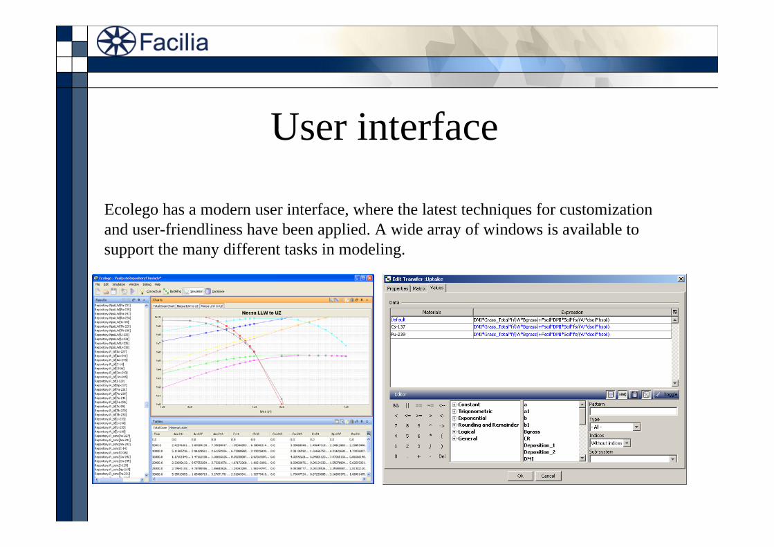
User interface
Ecolego has a modern user interface, where the latest techniques for customization and user-friendliness have been applied. A wide array of windows is available to support the many different tasks in modeling.

Hierarchical models

Database of radionuclides and parameters

SimulationsEcolego can handle everything from simple systems, to huge, stiff problems.
Monte Carlo simulations With an impressive list of probability density functions (PDFs), together with Monte Carlo and Latin Hypercube sampling and parameter correlation settings, Ecolego has everything needed for advanced probabilistic analysis.
Sensitivity analysis Rank correlation coefficients are available for tornado plots or correlation tables. These can be used to find the parameters in a model that influence results the most.
Post-processingSimulation outputs can be re evaluated using post-processing functions, without re-running simulations.

Ecolego Player
Ecolego Player is a free tool for running models created with Ecolego.
It allows for people not having Ecolego to perform simulations of any models created with Ecolego, including changing the parameter values etc.
The only restriction is that the structure of the model cannot be changed.

Summary• Ecolego can be used for development of specialized models which.
These can be used to set up Assessment Models applicable to specific situations.
• Once the models have been implemented in Ecolego, these can be distributed with the help of the Ecolego player.
• Model sets based on Ecolego have been developed in other projects:
SAFRAN (IAEA project) - Safety Assessment Framework for Radioactive Waste Management and Decommissioning.
2-FUN (EC project): Integrated model for assessment of risk from radionuclides and chemicals

Assessment of current doses from uranium tailings
= EcoMonitor LLC

Summary
• Swedish Radiation Protection Authority: Assessment of Risks to Human Health and the Environment from Uranium Tailings in Ukraine - Phase 1 report. Facilia ENSURE Report: TR/SIUS/01.
• IAEA: Apendix: “Assessment of doses from exposures to elevated levels of natural radionuclides in areas close to uranium tailings in Tajikistan and Uzbekistan” of the IAEA Report: Safe Management of Residues from Former Mining and Milling Activities in Central Asia. Regional Technical Cooperation Project RER/9/086.
Presentation of results derived from two main studies:
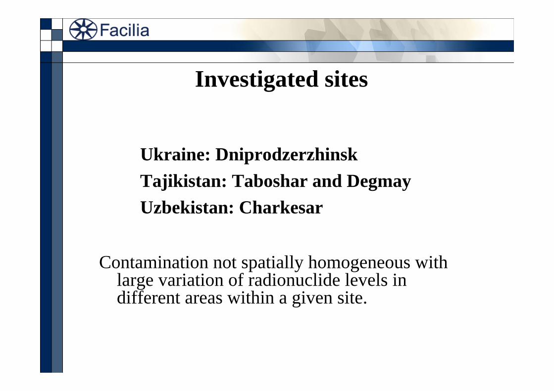
Investigated sites
Ukraine: DniprodzerzhinskTajikistan: Taboshar and DegmayUzbekistan: Charkesar
Contamination not spatially homogeneous with large variation of radionuclide levels in different areas within a given site.

Dniprodzerzhinsk Site, Ukraine
42 M tonnes 3,2 x 10¹⁵ Bq 258 000 inhabitants

Two sites in Tajikistan
1
Degmay tailings near Khudjand and ChkalovskTaboshar tailing site
7,6 M tonnes 12 000 inhabitants 20 M tonnes 16 000 GBq
salt covers with 238U 10-20 Bq g-1 164 000 & 22 000 inhabitants

Mines and disposal areas near Charkesar village, Uzbekistan
482 000 m3 3 x 10¹³ Bq 2 500 inhabitants

European data extracted from TREN report “Situation concerning uranium mine and mill tailings in an enlarged EU” (2006)
Country total

Methodology Hazard identification
Hazard 1 Hazard 3 etc
Exposure pathways
Assess current dose ratesto exposed groups
Quantify hazards
Hazard 2
Scenarios
Use of models,dose rates/unit time, etc
Monitoring programmes
Identify exposed groups
Quantify risk…

Identification of hazards
Monitoring:
• Gamma dose rates outside and inside of buildings
• Radionuclide concentrations – aerosols, soils and tailing materials– in water and food products (not at the Ukrainian site)
• Radon concentrations outside and inside buildings

Identified hazards
Dniprodzerzhinsk • Workers on the site get the highest radiation doses• Elevated radionuclide and radiation levels:
a) inside and outside polluted buildings b) Hot Spots in the forestc) in the different tailing sites
Taboshar • Elevated radionuclide and radiation levels:a) indoors and outdoors at settlementb) at tailings, locals go and animals grazec) at pits, locals visit and swimd) in waters contaminated by tailings or/and pits
Degmay • External exposure to gamma radiation and radon• Elevated radionuclide and radiation levels:
a) in the Degmay settlementb) at the uranium tailingsc) in ground waters (water from local wells)
Charkesar • Tailing materials used for house construction• Elevated radionuclide and radiation levels:
a) areas close to and away from the industrial siteb) at the industrial sitec) in water bodies, e.g. springs, mine waters, rivers

Derivation of dosesTo provide a basis for necessary exposure assessments at
these sites, we used the methodology (and models) highlighted by the German Federal Ministry for the Environment (BMU), Nature Conservation and Reactor Safety (1999):
“ Berechnungsgrundlagen zur Ermittlung der Strahlenexposition infolge bergbaubedingter Umweltradioaktivität (Berechnungsgrundlagen -Bergbau)”
[Assessment principles for estimation of radiation exposures resulting from mining-related radioactivity in the environment (Assessment principles for mining)]

Exposure pathways
• soil contamination for reference persons inside and outside buildings
• aerosols inside and outside buildings
• in, and exposure to, locally grown foodstuff (not yet included in the Ukraine project)
• exposure through the direct ingestion of soil
• inhalation of 222Rn and its short lived progeny

Chosen radionuclides
1. 238U 234U 230Th 226Ra 210Po 210Pb
2. 235U 231Pa 227Ac
3. 232Th 228Ra 228Th
This may lead to slight underestimation of these doses

Screening models placed in Ecolego

Comparison of doses between the four sites

Comparison of doses between all site categories
MinMax

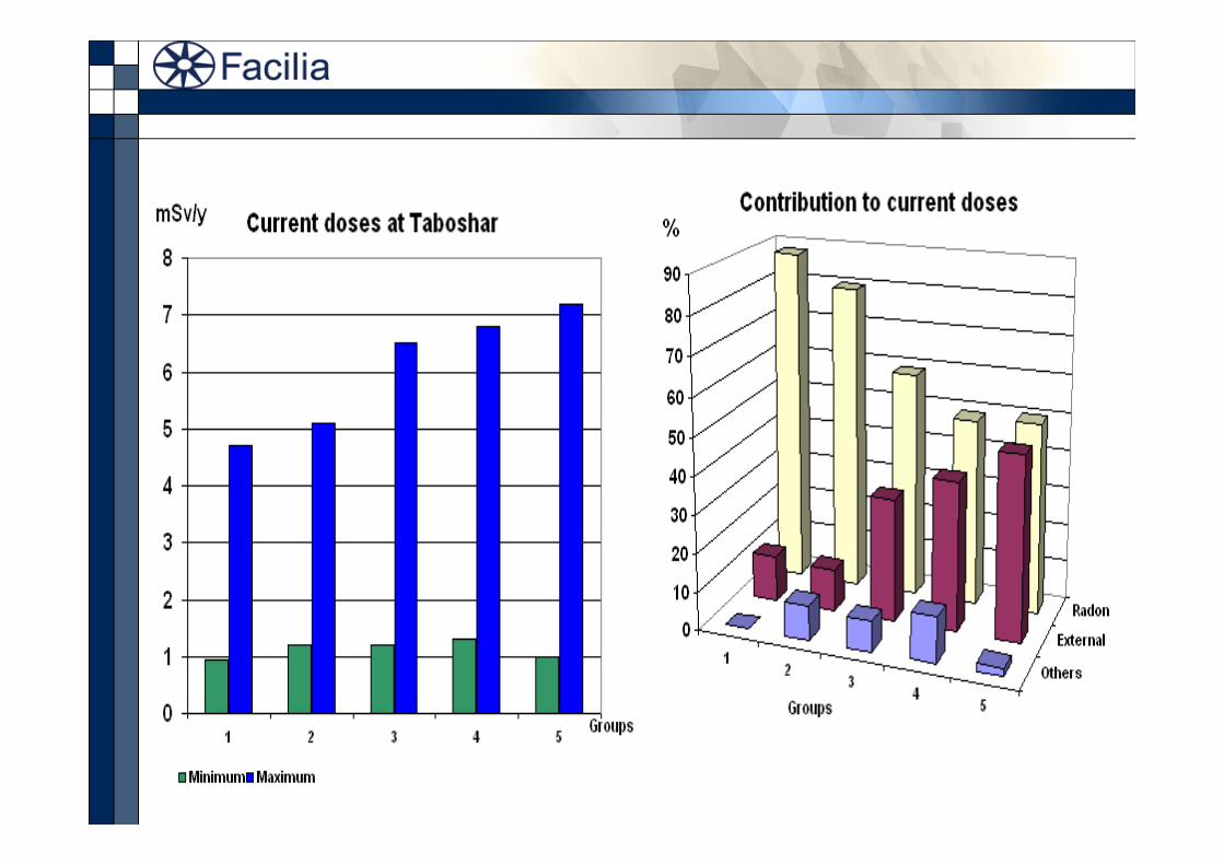
Example: current doses at TabosharScenarios:

Dniprodzerzhinsk

Migration from the tailings

Prognoses for different remediation alternatives

SummaryA consistent approach to deriving doses to exposed groups of
people to uranium tailing contaminants has been applied to four locations in Ukraine and Central Asia.
Dose rates can be calculated by identifying hazards and quantifying them based on exposure pathways.
This approach forms the basis for quantifying the risk of exposure to given groups of the population.
Test Cases based on these studies could be developed in the frame of the EMRAS WG 2

Mathematical Models for Assessing Remediation of Radioactively
Contaminated Sites
IAEA TECDOC – under development
Rodolfo Avila, Facilia ABHorst Monken-Fernandes, IAEA
Brent Newman, IAEAJiri Simunek, University of California
George Yeh, University of Central Charley Yu, Argonne National Laboratory

Table of Contents• INTRODUCTION• CONCEPTUAL MODELS• SOURCE TERM MODELS• ATMOSPHERIC DISPERSION MODELS• VADOSE ZONE MODELS• GROUNDWATER MODELS• INTEGRATED SUB-SURFACE MODELS• SURFACE WATER MODELS• EXPOSURE ASSESSMENT• APPLICATION FOR DECISION MAKING IN ENVIRONMENTAL
REMEDIATION• ASSESSMENT OF REMEDIATION SOLUTIONS• DEMONSTRATIVE EXAMPLES

SOURCE
ATMOSPHERE
VADOSE
GROUNWATER
LAND SURFACE
SURFACE WATERWELL
Release
Groundwater transport
Deposition
Leaching
DischargeAbstraction
Irrigation
CONTAMINATED AREA RECEPTOR LOCATION
Deposition
Surface runoff
Recharge
Release
Atmospheric dispersion
Main transport pathways

Processes influencing the radionuclide transport
ATMOSPHRainfallDry depositionGas uptake
RainfallDry depositionGas uptake
RainfallDry depositionGas uptake
ResuspensionVolatilization/EmanationEvaporationTranspiration
SourcePercolationAdvectionDiffusionDispersionColloid transp.
ErosionSurface runoffSedimentation
VadoseRechargeAdvectionDiffusionDispersionColloid transp.
Capillary riseAdvectionDiffusionColloid transp.
GWDischarge/Seepage Pumping
ResuspensionVolatilization/EmanationEvaporationTranspiration
InflitrationAdvectionDiffusionDispersionColloid transp.
LAND SURFACESurface runoff
Recharge IrrigationFlooding SURFACE
WATER
IrrigationWell

Processes in the source, the vadoze, the groundwater and the surface land compartments
INPUT
AQUEOUSAdsorption / Surface complexationIon exchange
Precipitation VolatilizationHeterogeneous reactionDiffusionDecay (Rn, Tn)
DesorptionIon exchange SOLID
Co‐precipitation Decay (Rn, Tn)
Dissolution Co‐precipitationSUSPENDED
Decay (Rn, Tn)
CondensationDiffusionDecay (Rn, Tn)
Decay (Rn, Tn) Decay (Rn, Tn)GASEOUS
MICROBES
OUTPUT

Summary
• The models described in the TECDOC could be used in this WG for selected study cases,
• The models could be implemented in a toolbox that could be made freely available to member states