appraisal report the subject property located: 2020, …
TRANSCRIPT

1
APPRAISAL REPORT
THE SUBJECT PROPERTY LOCATED:
2020, 2026 and 2046 Solano Street,
Corning, California
REPORT PREPARED FOR
David Wolffs 2605 Tulare Avenue El Cerrito, CA 94530

2
May 4, 2021 David Wolffs 2605 Tulare Avenue El Cerrito, CA 94530 Dear David: In accordance with your request, I have prepared an opinion of the Fair Market Value of the subject property, which is located at 2020 and 2026 and 2046 Solano Street, Corning California. I have valued this property as of the valuation date of April 7, 2021. This appraisal report is prepared in compliance with the Uniform Standards of Professional Appraisal Practices (USPAP) requirements. By reason of my investigation and by virtue of my experience, I have been able to form and have formed the opinion that the requested Fair Market Value of the subject property, as of the valuation date of April 7, 2021, is as follows:
FAIR MARKET VALUE………………………………………....………$1,500,000
Your attention is respectfully invited to the following report, which contains certain exhibits and factual data upon which the value conclusions are partially predicated.
Respectfully submitted,
____________________________ Michael H. Evans, FASA, FRICS California State Certified General Real Estate Appraiser #AG002019 Recertified until October 28, 2022

3
TABLE OF CONTENTS TITLE PAGE LETTER OF TRANSMITTAL TABLE OF CONTENTS INTRODUCTION EXECUTIVE SUMMARY ............................................................................................................................ -4- THE APPRAISAL PROCESS ..................................................................................................................... -5- SCOPE OF APPRISAL............................................................................................................................... -6- COMPETENCY .......................................................................................................................................... -7- PURPOSE AND INTENDED USE OF APPRAISAL .................................................................................. -7- FAIR MARKET VALUE DEFINED .............................................................................................................. -7- IDENTIFICATION OF THE SUBJECT PROPERTY .................................................................................. -8- PROPERTY RIGHTS APPRAISED ............................................................................................................ -8- DEFINITION OF FEE SIMPLE ESTATE .................................................................................................... -8- DATE OF VALUATION ............................................................................................................................... -8- ASSUMPTIONS AND LIMITING CONDITIONS ........................................................................................ -8- TEHAMA COUNTY REGIONAL MAP ...................................................................................................... -11- TEHAMA COUNTY AREA ANALYSIS ..................................................................................................... -12- IMMEDIATE AREA MAP .......................................................................................................................... -24- IMMEDIATE AREA ANALYSIS ................................................................................................................ -24- MARKET TRENDS ................................................................................................................................... -25- NATIONAL FLOOD INSURANCE PROGRAM ........................................................................................ -28- GENERAL PLAN AND ZONING .............................................................................................................. -29- TAXES…….…. ......................................................................................................................................... -31- PHYSICAL DESCRIPTION SUBJECT PHOTOGRAPHS .................................................................................................................... -32- ASSESSOR'S PLAT MAP ........................................................................................................................ -40- PHYSICAL DESCRIPTION ...................................................................................................................... -41- STATEMENT OF OWNERSHIP ............................................................................................................... -46- HIGHEST AND BEST USE ...................................................................................................................... -46- ANALYSIS SALES COMPARISON APPROACH ....................................................................................................... -49- COST APPROACH TO VALUE ................................................................................................................ -85- INCOME APPROACH .............................................................................................................................. -87- RECONCILIATION OF VALUES .............................................................................................................. -90- CERTIFICATION OF VALUE ................................................................................................................... -91- ADDENDA SALES SUMMARY ................................................................................................................................... -93- SALES MAP ............................................................................................................................................. -94- LEGAL DESCRIPTION............................................................................................................................. -96- QUALIFICATIONS OF MICHAEL H. EVANS, FASA ............................................................................... -98- REFERENCES…….…. .......................................................................................................................... -103-

4
EEXXEECCUUTTIIVVEE SSUUMMMMAARRYY Appraisal Type: Appraisal report Property Type: Retail property Location of Property: 2020 and 2026 and 2046 Solano Street, Corning California Assessor’s Parcel Numbers:
Assessor's Parcel Number(s)
Acres
071-080-008 1.40
071-080-009 0.48
071-080-010 0.84
071-080-015 0.29
Total 3.01
Land Configuration: Irregularly shaped Date of Appraisal: April 7, 2021 Zoning/General Plan: Commercial and Commercial Land Area: 3.01 gross acres Improvements: Retail buildings Highest and Best Use: Existing retail use Values: SALES COMPARISON APPROACH $1,462,000 COST APPROACH $1,916,000 INCOME APPROACH $1,528,000 Fair Market Value: $1,500,000

5
THE APPRAISAL PROCESS The appraisal process is an orderly procedure of gathering information from the market which
will lead to an opinion of value. This information is obtained from many sources, but the best
source is through recent sales of similar type properties. All sales used are examined and
confirmed by, the buyer, the seller, or a party knowledgeable to the transaction. All pertinent
facts from the sales are analyzed, classified, and interpreted for use in the approaches to
value.
There are three approaches to value that are considered when arriving at an opinion of value
for real estate. These are the Sales Comparison Approach, the Cost Approach, and the
Income Approach.
The Sales Comparison Approach is a method of comparing recent sales of similar properties
to the subject property. This approach is based on the principle that the prudent investor would
pay no more for a property than the cost of acquiring a satisfactory alternative property that
possesses physical, economical, and financial comparability. The value of a particular property
tends to coincide to the value indicated by the actions of informed buyers and sellers in the
marketplace for similar properties. A number of sales are investigated in order to determine the
value of the subject property. A discussion and analysis of the sales are provided and
adjustments are typically made for date of sale, physical and economical characteristics, and
terms of sale or financing.
In the Cost Approach, the value of the land is estimated from market data. Next, the
replacement cost of the buildings is estimated and the accrued depreciation is estimated and
subtracted from the replacement cost estimate, providing an indication of the contributing value
of the buildings. The estimated value of the land, added to the contributing value of the
buildings, results in an opinion of value.
The Income Approach is based on an accurate measurement of a property's productivity under
typical management, a conversion of the yields into gross and net income, and capitalization of
this net income into an indication of market value. Whenever possible, all three approaches
should be used. One approach, however, will often be given greater weight than the others,
depending on the type of property, the most convincing factual data available, and the
objective of the appraisal.

6
SCOPE OF APPRAISAL
This is an "appraisal assignment" as defined by the American Society of Appraisers and the
Royal Institution of Chartered Surveyors, within the standards of professional practice. The
services resulting from this assignment have been performed in a manner consistent with the
requirements of these organizations and the analysis, opinions, and conclusions are those of a
disinterested third party. All appropriate data deemed pertinent to the solution of the appraisal
problem has been collected, confirmed, and reported in conformity with the standards of
professional practice and the code of professional ethics of the American Society of
Appraisers. This appraisal report reflects a summary of the data, analysis, opinion, and
conclusions of the author.
For completion of this appraisal assignment, a preliminary survey is conducted, the property to
be appraised is inspected, and a search for relevant market data is completed. By use of
county records, a sales search is conducted for transactions involving properties which meet
the criteria deemed by the appraiser to be appropriate for comparison to the subject. In
addition, listings are obtained from knowledgeable sources within the area of the subject,
including real estate brokers and participants within the real estate market. The sales
information collected is then screened, inspected, confirmed, and analyzed for use within the
comparison process. Supplementary information such as comparative costs, rents, and market
data are collected from knowledgeable sources as necessary, as well as from files maintained
for this purpose within the office of the appraisal firm.
The data is analyzed through the appropriate approaches to value explained in the Analysis
section of this report and finally, the appraisal containing the description, analysis, and
conclusions is completed.

7
COMPETENCY
The Uniform Standards of Professional Appraisal Practice (USPAP) require that prior to
accepting any assignment or entering into an agreement to perform any assignment, an
appraiser must properly identify the problem to be addressed and have the knowledge and
experience to complete the assignment completely or alternatively:
1. Disclose the lack of knowledge and/or experience to the Client before accepting the assignment. Take all steps necessary or appropriate to complete the assignment competently. 3. Describe the lack of knowledge and/or experience and the steps taken to complete the assignment competently in the report. The author of this report has had previous experience appraising real estate in the subject’s
area, and is familiar with the geographical area in which the property is located. Furthermore,
properties which are physically and economically similar to the subject property have been
common appraisal assignments. The author believes that he possesses the knowledge and
experience to complete this assignment competently.
PURPOSE AND INTENDED USE OF APPRAISAL
The purpose and intended use of this appraisal report is to assist the client in making financial
decisions regarding the subject property in estate related matters.
CLIENT AND INTENDED USER OF APPRAISAL
David Wolffs and designees are the clients and the intended users of this appraisal report.
The IRS is a third party unintended user of this appraisal report.
FAIR MARKET VALUE
Estate Tax: Treas. Reg. §20.2031-1(b).
“The fair market value is the price at which the property would change hands between a willing buyer and a willing seller, neither being under any compulsion to buy or sell and both having reasonable knowledge of relevant facts. The fair market value of a particular item of property includible in the decedent’s gross estate is not to be determined by a forced sale price. Nor is the fair market value of an item of property the sale price in a market other than that in which such item is most commonly sold to the public, taking into account the location of the item wherever appropriate.”

8
IDENTIFICATION OF THE SUBJECT PROPERTY
The subject property is identified in a legal description located in the Addenda section of this
appraisal report. The subject property is located at 2020 and 2026 and 2046 Solano Street,
Corning California. The Tehama County Assessor's office identifies the subject property as
Assessor's Parcel Numbers: 071-080-008; 009; 010; and 015. A copy of the Assessor’s Map is
located in the Physical Description section of this report. This map shows the basic outline of
the subject property, and its relationship with the surrounding area.
PROPERTY RIGHTS APPRAISED
The rights of the subject property to be appraised are for the fee simple estate. The definition
of these property rights are as follows:
DEFINITION OF FEE SIMPLE ESTATE
Absolute ownership unencumbered by any other interest or estate; subject only to the
limitations of governmental powers of taxation, eminent domain, police power, and escheat.1
DATE OF VALUATION
I have valued this property as of the inspection date, on April 7, 2021.
ASSUMPTIONS AND LIMITING CONDITIONS
1) That I assume no responsibility for matters legal in character, nor do I render any
opinion as to the title, which is assumed to be good and marketable. All existing liens and
encumbrances securing payment of money have been disregarded, and the property is
appraised as though free and clear under responsible ownership and competent management.
2) That although dimensions are taken from sources considered reliable and verifying,
measurements were made and such verification should not, in any way, be construed as a
survey. Areas not calculated by an engineer are not guaranteed accurate from an engineering
standpoint.
3) That legal descriptions, as furnished, are assumed to be correct.
1 The Appraisal of Real Estate, 12
th Edition, Page 68

9
4) That information obtained for use in this appraisal is believed to be true and correct to
the best of my ability; however, no responsibility is assumed for errors or omissions, nor for
any information not disclosed which might otherwise affect the valuation opinion. However, the
appraiser reserves the right to consider and evaluate such data upon its disclosure.
5) That there exist no undisclosed restrictions or prohibitions concerning the possible use
or development of the property for any purpose for which it is available.
6) That no responsibility is assumed for any condition not readily observable from the
customary inspection of the premises, which condition might affect the valuation, except those
items specifically mentioned in this report.
7) That exhibits included herein are to assist in visualizing the property and the
surrounding area and are not to be construed to be the result of a survey.
8) That oil, gas, and mineral rights were not considered in making this appraisal unless
otherwise stated.
9) That possession of this report, or a copy thereof, does not carry the right of use for any
purpose for any but the client or their authorized agent without first obtaining the written
consent of the author.
10) That testimony or attendance in court, by reason of this appraisal with reference to the
property in question, shall not be required unless prior arrangements are made.
11) Unless otherwise stated in this report, the existence of hazardous material, which may
or may not be present on the property, was not observed by the appraiser. The appraiser
has no knowledge of the existence of such materials on or in the property. The appraiser,
however, is not qualified to detect such substances. The presence of substances such as
asbestos, urea-formaldehyde foam insulation or other potentially hazardous materials may
affect the value of the property. The value opinion is predicated on the assumption that there
is no such material on or in the property that would cause a loss in value. No responsibility is
assumed for any such conditions, or for any expertise or engineering knowledge required to
discover them. The client is urged to retain an expert in this field, if desired.

10
The Four Forces
As indicated in the Appraisal Process section of this report the Four Forces constitute an
important portion of the valuation process. How these forces affect the region and/or
neighborhood has to be addressed. It is noted that regions and or neighborhoods can offer
different advantages to its inhabitants, and are said to differ in quality. The quality of a region
or a neighborhood can best be judged in terms of the needs and standards of its occupants.
The major factors that affect the quality of any area can be grouped as physical, economic,
social, and political in nature.
These major factors are often referred to as the four forces, which affect the Market Value of
any type of property within a defined region or neighborhood. Typically, the area surrounding
any property being appraised can only be understood via an analysis of the county, city or
town, and the immediate area where this property exists. It is noted that the immediate area
analysis is considered to be a direct indication of the way the four forces influence the overall
marketability of a property.
Based on the above, the author of this report researched and reported analyses of Tehama
County, the city of Corning and the immediate area where this property is located. They are as
follows on the next pages:

11
TEHAMA COUNTY AREA MAP

- 12 -
TEHAMA COUNTY AREA ANALYSIS
History & Location
Tehama County was created from parts of Butte, Colusa, and Shasta counties in 1856.
Named for the City of Tehama, some of the suggested roots for the word Tehama are “hot
lowlands” (Arabic) and “high water” (local Native
American).
Tehama County’s 2,976 square miles are
surrounded by snow-covered mountains, including
Mt. Shasta, Mt. Lassen, and the Trinity Mountain
Range. The Sacramento River runs through the
county, providing a variety of fishing and boating
activities. Red Bluff, the county seat, is located 135 miles north of Sacramento and 444 miles
south of Portland, Oregon. Surrounding Tehama County is Shasta County to the north,
Plumas and Butte to the east, Glenn to the south, and Trinity and Mendocino Counties to the
west.
Environmental Characteristics
Situated in the northern end of the Sacramento Valley, Tehama County consists of a broad,
low alluvial plain that is bordered on the east by
the Sierra Nevada Mountain Range and on the
west by the Pacific Coast Mountain Range. The
valley extends from Red Bluff and becomes
larger as it fans out south along the Sacramento
River. The Sacramento River drainage area
flows through the middle of Tehama County in a
north-south direction, with the North Coast Range lying west of the river and the foothills of the
Sierra Nevada lying east of the river. Tehama County has an annual rainfall of 21 inches per
year. In higher elevations, the county receives over 50 inches of rainfall, as well as a
considerable amount of snow.
Tehama County experiences cool, wet winters and hot, dry summers. The growing season in
the Sacramento Valley is approximately 260 days.

- 13 -
Social Characteristics
As of 2017, the population for Tehama County as a whole was reported at 63,926 by the US
census. The population in Tehama County has been slowly increasing from 2008’s estimate of
62,419.
Transportation
State Highway 99E runs southeasterly between Red Bluff and Chico. Rail lines of the
Southern Pacific Railroad run through Tehama County on their way between San Francisco
and Portland. State Highway 36 branches off east and west from Red Bluff to serve the
mountainous and forested areas of the county. Truck services are provided by various freight
lines, as well as by United Parcel. The Greyhound and Continental Trailways bus lines serve
Red Bluff, with overnight service to Sacramento and San Francisco, as well as Reno, Nevada,
and Medford and Klamath Falls, Oregon.
The rest of the county is served by an extensive system of good county roads. Many of these
roads are asphalt paved.
Recreation
The county also has an extensive system of forest highways and roads utilized for logging,
lumbering, and recreation. Red Bluff is the official head of navigation for the Sacramento
River. It is 246 miles above Suisun Bay where the river empties into the San Francisco Bay.
The recreation minded will find many activities available in Tehama County. Year-round
fishing can be enjoyed in the Sacramento River which winds its way through the county.
Streams to the west, north, and east offer excellent trout fishing. The salmon spawning facility
located at the Red Bluff Diversion Dam is a multi-million-dollar Federal Government project.
This facility is one of the largest artificial salmon spawning areas in the world. Upon the
closing of this dam, the seasonal Red Bluff Lake is formed. Home to many summer
recreational activities, Red Bluff Lake is a favorite of many local residents. Lassen Volcanic
National Park, only minutes east of Red Bluff, contains rugged peaks, green meadows, trout
streams, and lakes that draw vacationers from near and far to hike in the cool air and camp at
the many developed sites.

- 14 -
Mt. Lassen is the largest plug dome volcano in the world; however, all four types of volcanoes
that can be found in the world can also be found in the small area of the park. This active
volcano experienced its last eruption in 1921. In 1915, the peak had its largest eruption,
blowing volcanic material over seven miles up into the stratosphere. Large volcanic rocks from
this eruption are easily visible over a hundred miles away. Lassen Park looms 10,453 feet
above the valley floor with 160 square miles contained within the park boundaries. Lassen
Volcanic National Park is also very thermally active, with hot springs, fumaroles, and bubbling
mud pots.
Economic Characteristics
As of March 2021, the unemployment rate for Tehama County is 7.9%, which is an increase
compared to 2019’s 6.9%, as per the following charts:
April 16, 2021 Employment Development Department
March 2020 Benchmark Labor Market Information Division, (916) 262-2162
Data Not Seasonally Adjusted http://www.labormarketinfo.edd.ca.gov
Historical Civilian Labor Force
Tehama County
Notes: 1) Data may not add due to rounding. The unemployment rate is calculated using unrounded data.
2) Labor force data for all geographic areas for 1990 to 2021 now reflect the March 2020
annual revision (or benchmark) and Census 2014 population controls at the state level.
2021 Labor Force Employment Unemployment Unemp. Rate
January 25,220 23,190 2,040 8.1%
February 25,530 23,460 2,070 8.1%
March 25,240 23,240 2,000 7.9%
April May June July August September October November December Annual Averages

- 15 -
2020 Labor Force Employment Unemployment Unemp. Rate
January 25,910 24,240 1,670 6.4%
February 25,970 24,380 1,590 6.1%
March 26,100 24,310 1,790 6.9%
April 25,420 21,680 3,740 14.7%
May 24,860 21,790 3,070 12.4%
June 25,670 22,910 2,760 10.7%
July 25,110 22,520 2,590 10.3%
August 25,660 23,390 2,280 8.9%
September 25,560 23,490 2,070 8.1%
October 26,140 24,230 1,910 7.3%
November 25,360 23,700 1,660 6.6%
December 25,180 23,160 2,020 8.0%
Annual Averages 25,580 23,320 2,260 8.8%
2019 Labor Force Employment Unemployment Unemp. Rate
January 25,510 23,660 1,840 7.2%
February 25,520 23,800 1,720 6.7%
March 25,420 23,660 1,760 6.9%
April 25,170 23,720 1,440 5.7%
May 25,320 24,030 1,300 5.1%
June 25,610 24,140 1,470 5.7%
July 25,430 23,900 1,530 6.0%
August 25,510 24,090 1,420 5.6%
September 26,050 24,860 1,190 4.6%
October 26,090 24,860 1,240 4.7%
November 25,740 24,490 1,250 4.9%
December 25,250 23,920 1,330 5.3%
Annual Averages 25,550 24,090 1,460 5.7%
2018 Labor Force Employment Unemployment Unemp. Rate
January 25,340 23,690 1,660 6.5%
February 25,600 23,920 1,690 6.6%
March 25,330 23,600 1,730 6.8%
April 25,260 23,790 1,470 5.8%
May 25,290 23,990 1,300 5.1%
June 25,600 24,090 1,510 5.9%
July 25,380 23,800 1,570 6.2%
August 25,410 23,970 1,440 5.7%
September 25,790 24,530 1,260 4.9%
October 26,070 24,820 1,240 4.8%
November 25,510 24,220 1,280 5.0%
December 25,290 23,800 1,490 5.9%
Annual Averages 25,490 24,020 1,470 5.8%

- 16 -
The following is a list of major employers in the County:
Employer Name Location Industry
Bell-Carter Olive Co Corning Olives (Whls)
Cal Fire Red Bluff Fire Departments
Forestry & Fire Protection Red Bluff Government-Forestry Services
Home Depot Red Bluff Home Centers
Pacific Gas & Electric Co Red Bluff Electric Companies
Petro Stopping Ctr Corning Truck Stops & Plazas
Precision Towing Red Bluff Wrecker Service
Raley's Red Bluff Grocers-Retail
Red Bluff Union High School Red Bluff Schools
Rolling Hills Casino Corning Casinos
Sierra Pacific Industries Corning Lumber-Manufacturers
Sierra Pacific Industries Red Bluff Lumber-Manufacturers
Sierra Pacific Industries Proberta Lumber-Manufacturers
Sierra Pacific Windows Inc Red Bluff Windows
St Elizabeth Community Hosp Red Bluff Hospitals
State Dept Forrestry & Fire Red Bluff Fire Departments
Tehama County Education Dept Red Bluff County Government-Education Programs
Tehama County Health Svc Red Bluff County Government-Public Health Programs
Tehama County Health Svc Red Bluff County Government-Public Health Programs
Tehama County Health Svc Agcy Red Bluff County Government-Public Health Programs
Tehama County Mental Health Red Bluff County Government-Public Health Programs
Tehama County Sherriff/Records Red Bluff Government Offices-County
Tehama County Social Svc Dept Red Bluff County Government-Social/Human Resources
Walmart Red Bluff Department Stores
Walmart Distribution Ctr Red Bluff Distribution Centers (Whls)

- 17 -
Agriculture
The total gross value of Tehama County agricultural production in 2019 was $300,826,400,
which represents an increase of 19% ($48,883,600) from the 2018 total values.
Walnuts remained Tehama County’s top crop with an overall value of $88,039,200. The
production of table olives and prunes rebounded significantly from 2018 in which early spring
temperatures decreased production yields on these crops that year.
The top five highest value agricultural crops for Tehama County in 2019 were:
1. Walnuts $88,039,200 (38% increase in value due to increase in price and acreage)
2. Almonds $40,922,800 (7% decrease in value due to decrease in yield)
3. Beef Cattle $27,610,800 (1% increase in value due to increase in number of head sold)
4. Table Olives $29,535,500 (210% increase in value due to increase in yield)
5. Prunes $23,281,900 (33% increase in value due to increase in yield)
See the following chart on the next page showing a summary of the past few years:

- 18 -

- 19 -
With an abundance of good pasture and range land, Tehama County is the hub of the cattle
and sheep industry in Northern California. There are more beef cattle in the county than
people. Cattle of all kinds contribute greatly to the economy of Tehama, with three of the top
nine income producers being livestock.
Governmental Characteristics
Tehama County is a general law county governed by an elected
five-member Board of Supervisors. The general population also
has the responsibility of electing the County Assessor, the
Auditor/Controller, the Treasurer/Tax Collector, the
Clerk/Recorder, the District Attorney, and the Sheriff/Coroner.
The Board of Supervisors is in charge of appointing the County
Administrator who oversees the day-to-day operations of the
County. The County Administrator in turn appoints the
Agricultural Commissioner and the County Counsel. Some of the
major responsibilities of the County government include the
Sheriff Department, the justice courts, Public Health, and Public
Works (including road maintenance). The major County agencies affecting real estate are the
Planning Commission and the Assessor’s office. Real estate assessments and taxes change
dramatically in California in 1978 with the passage of Proposition 13. All counties within
California were required to appraise all properties, except certain agricultural and timber
properties, at full market value as the property existed on March 1, 1975, with increases limited
to a maximum of 2% annually. By the passage of Proposition 13, the basic tax rate in
California is $1.00 per $100.00 of appraised value, plus any taxes levied to cover bond
indebtedness for county, city, school, or other taxing agencies. The County Assessor’s office
is responsible for the appraisal of each property within the constraints of Proposition 13 and
appraised values and tax rates are published annually after July 1st. The results of Proposition
13 have included some severe economic difficulties for county governments in northern
California.

- 20 -
CITY OF CORNING ANALYSIS:
Location and History
Corning is one of three incorporated cities in Tehama County, located on Interstate 5. It is the
mid-point between Portland, Oregon, and Los Angeles, California. Chico is located
approximately 25 miles southeast of Corning, with Red Bluff located 17 miles to the north, and
Orland located 15 miles to the south.
During the mid-1800’s, many people were traveling to California. Though many sought gold,
several families settled down in the area and began agricultural production. The city was
named for John Corning, the nephew of Erastus Corning, president of the New York Central
Railroad for many years. He became Assistant Superintendent of the Central Pacific Railroad
in 1868. It was common practice for towns to be named in honor of railroad men. Corning,
New York, was named in honor of John's uncle, Erastus, and Corning, California, was named
in honor of John when he passed away in 1878.
Environmental Characteristics
The City of Corning is a rural community that covers 2.9 square miles within Tehama County.
The elevation is approximately 270 feet above sea level. On average, temperatures in the
warmer months of July and August reach into the mid to upper 90’s, whereas the coldest
months, December and January, can dip as low as the mid 30’s. The average annual
precipitation for Corning is 24.2 inches, producing an environment conducive to diverse
agriculture.
Woodson Bridge State Recreation Area is located on South Avenue, just six miles east of
Interstate 5 at Corning. Nestled in beautiful oak woods on the Sacramento River between
Chico and Red Bluff, Woodson Bridge offers year-round camping, fishing, boating, and hiking
in an unspoiled natural setting. Over a hundred plant species have been identified throughout
the park; the most prominent is the large valley oak. The California black walnut, Oregon ash,
black cottonwood, sycamore, and willow are also plentiful. Beneath the oaks and cottonwoods
along the river is a profusion of elderberry, wild grape, other shrubs, and wildflowers in season.

- 21 -
Next to Woodson Bridge is Tehama County Park, which offers a broad sand-and-gravel beach
for wading, but the water is chilly even in summer, generally ranging from 58 to 60 degrees.
The county park also offers a free boat-launching ramp, picnic grounds, a cafe, and a privately
operated trailer park with utility hookups, a small store, fishing bait, a boat dock, and a boat
and motor rental are available next to the county park.
Social Characteristics
According to the US Census, the population for the City of Corning was 7,535 in 2018.
Transportation
Corning is serviced by the Southern Pacific Railroad. Interstate 5 runs north to south through
the city, a major thoroughfare for California. Greyhound Bus Lines also service the City of
Corning, providing transcontinental service. Corning Municipal Airport Rainbow Aviation
provides for charter flights and personally owned planes, but the closest commercial flights
may be taken from Redding or Chico airports.
Cultural Opportunities
Corning is well known as the Olive City, home to the Bell Carter Olive Company, which is the
world's largest ripe olive cannery. Tours of the cannery are available for tourists.
Corning's history is displayed throughout the Corning Museum, which is located within the
Corning Chamber of Commerce, Corning City Hall, and Corning Police Department in the
historic Hotel Maywood building. The Corning Museum preserves and exhibits artifacts that
represent the cultural heritage of Corning and Tehama County specifically and northern
California in general. Displays at the museum include German and Japanese mounted
machine guns, articles of period clothing, tools, pictures and other items dating back to the
early days of Corning. There are also many historical items from the Hotel Maywood.
The Corning Chamber of Commerce presents several community events. The annual May
Madness car show has been held for the past nine years, providing multiple competitions for
various stock cars from all over northern California. It is a weekend event hosted by several of
the city’s vendors, including such activities as a pancake breakfast, raffles, and award
presentations.

- 22 -
Also hosted by the Corning Chamber of Commerce is the Corning Olive Festival. This annual
event is a full weekend in August, beginning on a Friday with the Olive Festival Parade, bed
and lawnmower races and a youth dance. Saturday includes a pancake breakfast, a walk
through Woodson City Park, music and entertainment, and children’s carnival games. There
are also arts, crafts, and food booths, with cook-off competitions, talent shows and the annual
Miss Corning Pageant. Corning also has 19 churches of various denominations, one library,
one newspaper, one radio station, 3 TV channels received direct, one TV cable system, three
banks, four parks, and two playgrounds. There are also several other recreational facilities
including a city swimming pool, tennis courts, and a bowling alley.
Educational Services
The Corning Elementary School District encompasses five elementary schools. Maywood
Middle School offers education services to grades 6-8. Olive View School consists of grades
3-5, West Street Elementary School includes kindergarten to third grade, and Rancho Tehama
School and Woodson Elementary School are open to students from kindergarten to fifth grade.
There are two high schools operating under the Corning Union High School District. Corning
Union High School has an enrollment of 986 students, grades 9-12. Centennial High School is
a continuation school with an enrollment of 67 students, grades 9-12.
Health Services
Corning has three physicians/surgeons, three dentists, two optometrists, two chiropractors,
and an ambulance service. There are three major medical centers located in nearby cities.
Mercy Medical Hospital and Shasta Regional Medical Center are located 50 miles north in
Redding. Enloe Medical Center is located in Chico, 25 miles southeast of Corning.
Economic Characteristics
The unemployment rate in Corning is 7.80% (U.S. avg. is 5.20%). Recent job growth is
Positive. Corning jobs have increased by 1.66 percent.

- 23 -
Government and Political Characteristics
The City of Corning operates under a Council-Manager form of city government. The City
Council is composed of a mayor and four other Council Members, who are elected by the
citizens of the City of Corning as their representatives to make the legislative and policy
decisions of the City, subject to the provisions of City Ordinances, Resolutions, and the
Government Code and the Constitution of the State of California. The City Council appoints the
City Manager who serves at their pleasure and who implements Council Policy. The Mayor
and City Council members also represent the City at official functions and in relationship with
other organizations.
The Mayor is elected by the voters every two years, and the City Council members are elected
for four year terms that overlap with the Mayor's term. Elections are held in November in even
numbered years. The California State Code requires every county and incorporated city to
have a general plan. This is a long range policy establishing a generalized pattern of future
land use which provides the basis for more detailed plans. Both the City and Tehama County
have a zoning code.
The City of Corning employs a small police department. Other jurisdictions include the
Tehama County Sheriff’s Department, the California Highway Patrol, and other state and
federal law enforcement agencies which have jurisdiction related to the many state and
environmental constraints.
The City of Corning is one of three incorporated cities in Tehama County. This agriculturally
dominated area also provides a full range of municipal services including Police, Fire, Parks
and Recreation, Library, Public Works and Municipal Airport. There is a continuing population
and economic growth which provides for increased development in the area.
A description of the immediate area of the subject property is as follows on the next page.

- 24 -
IMMEDIATE AREA MAP & IMMEDIATE AREA ANALYSIS
The subject property is located
in a commercial/retail area, on
the west side of the City of
Corning, in Tehama County.
The subject property has street
addresses of 2020 and 2026
and 2046 Solano Street,
Corning, Tehama County, CA.
The subject is located at the northeast corner of Edith Avenue and Solano Street, less
than ¼ of a mile east of the Solano Street and I-5 Interchange site. Easy access is
provided to the subject property via Solano Street, which is a four lane, asphalt paved
roadway that is city maintained.
The immediate area of the subject property consists mainly of commercial/retail types of
properties. Most of the facilities located along Solano Street consist of restaurants, gas
stations, banks, antique stores, delis, etc. As one advance further east of this roadway,
the usage starts getting intermixed with light industrial types of properties and older
homes, as Solano Street ends and joins with Hoag Road. However, it is noted that the
dominant usage in the immediate area of the subject property consists of a mixture of
commercial/retail usage.
The boundaries of the subject property are as follows: I-5 to the west, Hoag Road to
the east, and Solano Street to the north and south. Traffic is considered to be heavy
along this roadway since it has most of the commercial retail facilities in town, which is
considered advantageous to the property being appraised. This site has direct frontage
along Solano Street. All public utilities are available to this area including public water.
City sewer is available in the area as well.

- 25 -
Electrical power is provided by Pacific Gas & Electric Company, telephone service is
provided by Pacific Bell, and natural gas is also available. Solid waste collection is
available from several companies at competitive rates.
In conclusion, the subject property is located in a good retail/commercial area, at a very
close proximity to I-5, which provides it with the desired clientele, in general. As of the
valuation date, the subject property's neighborhood conforms to the general plan and
zoning ordinance.
MARKET TRENDS
As of the valuation date, there are limited sales of commercial lands and retail facilities
in the subject’s immediate area and in Corning in general; the Co Star system shows a
total of 16 retail sales since 2016 showing a range in sale price of $15.96 to as high as
$921.37 per square foot. There is not enough market data to establish a narrower range
for this type of property at this junction of this report, noting that comparable sales from
other competing markets will be used in valuing the subject property; in examining the
listings and sales however, one can state that the market although somewhat flat has
been at least stable. See the following comps statistics as extracted from the Co Star
system:

- 26 -
Market Conditions as Influenced by Current COVID 19 - Coronavirus Situation
The appraisal process is developed with a strong emphasis on completed transactions.
This is most reflected in the Sales Comparison Approach; however, the Cost Approach
and Income Approach are often reflective of somewhat lagging market data. Therefore,
rapid market changes are often not reflected in current market value appraisals.
USPAP requires analysis of current market conditions and credible value opinions are
dependent upon in-depth, ongoing, and current analysis of all factors that have
significant impact on market value.
On January 20, 2020, the first case of COVID-19 was confirmed in the state of
Washington and has rapidly increased throughout the nation as well as the world at an
exponential growth rate. As the virus has spread, significant impacts have been felt in
the stock market, oil prices, travel industry, lodging, food and beverage, and other
industries. The impact is rapid, significant, and as of now, the length, and eventual
overall damage is unknown. As of the date of report, market evidence (sufficient sale
data to indicate a market value impact) is not available and therefore current impact is
yet to be settled within the market. Several factors would of course contribute to this,
including the length of time the nation continues to be affected and the pace of the
eventual recovery once the virus is contained or growth is at least mitigated. Most
epidemiologists and medical professionals initially believed that within a 2-3-month
period, based upon government and private sector efforts, the virus spread would have
been mitigated. However, it is now clear that the far reaching effects of the pandemic
have yet to be fully realized and the duration of its influence is yet to be determinable.

- 27 -
Given the degree of uncertainty and current debate regarding the process of returning
to a more normal situation, there is a lack of adequate or sufficiently reliable market
data from which to develop a measurable economic impact. Even less evidence is
available how these historical and future potential events are affecting market
participants today. However, it is my opinion that overall, considering the market
statistics, the economic impact within the local agricultural, commercial and residential
real estate markets will be realized primarily in predominate marketing times.
Consequently, as of the effective date of the report, marketing times for properties
similar to the subject will likely experience an additional marketing time of 30 to 90 days
(or no additional marketing time if that is the case).
Exposure time, as reflective of the time exposed to the market prior to the effective date
would not be affected.

- 28 -
NATIONAL FLOOD INSURANCE PROGRAM
The subject property is located in Zone “X” a non flood zone area, as per FEMA panel
number 06103C1465H dated September 29, 2011. A copy of the FEMA map is as
follows:
FLOOD MAP

- 29 -
ZONING AND GENERAL PLAN
The subject’s parcel is zoned Commercial and the general plan is Commercial. A
description of the zoning ordinance, as originally received, is as follows:
Chapter 17.22 - C-3 GENERAL COMMERCIAL DISTRICT 17.22.010 - Generally.
This district classification is intended to be applied where general commercial facilities are
necessary for public service and convenience. The following specific regulations and the
general rules set forth in Sections 17.04.060 and 17.04.070 and Chapter 17.50 of this code shall
apply in all C-3 districts.
(Ord. 153 §11.01, 1959).
17.22.020 - Permitted uses.
In C-3 districts, permitted uses shall be as follows:
A. Uses permitted in the C-1 and C-2 districts;
B. The following and other uses which, in the opinion of the planning commission, are of a similar character:
1. Gasoline service stations; provided, that all operations except the servicing with gasoline, oil, air and water are carried on within a building,
2. Commercial repair garages, and incidental service uses,
3. Automobile sales and service, used car lots,
4. Wholesale distribution uses, warehouses,
5. Laundry and dry cleaning businesses using non-inflammable cleaning solvents,
6. Veterinary hospitals, animals to be kept in an enclosed structure,
7. Carwash;
C. All other commercial uses except those uses which are specified in Chapter 17.24 of this title as being permitted only in M-1 and M-2 districts;
D. Incidental storage and accessory uses, including repair operations and services, provided such uses shall be clearly incidental to the sale of products at retail on the premises, and shall be so placed and constructed as not to be offensive or objectionable because of odor, dust, smoke, noise or vibration.
E. Upon securing a conditional use permit, an on-site residence not to exceed one third the square footage of an active business establishment and occupied by the owner/proprietor or their agent, such residences are to be a secondary use to an active commercial enterprise, either upstairs or in the rear, with the storefront remaining commercial. No residential garages shall be permitted.
(Ord. 589 §7, 2001; Ord. 558 (part), 1996; Ord. 588 (part), 1996; Ord. 524 §§13, 13.1, 1992; Ord. 184 §1, 1962: Ord. 153 §11.02, 1959).

30
17.22.030 - Minimum height, bulk and space requirements.
In C-3 districts, the minimum height, bulk and space requirements shall be as
follows:
A. Lot area, width and coverage, none;
B. Side yard and front yard shall be as follows:
1. Side yard, none; except as required by the building code or other regulation, or where the side of a lot abuts an R district, the side yard shall not be less than ten feet.
2. Front yard, none; except where the frontage in a block is partially within an R district, the same setback shall be required as in the R district.
C. Rear yard, twelve feet where accessible from street, alley or parking lot for loading purposes. Building may project over rear yard area, providing fourteen feet clear vertical distance from ground level is maintained. Building Code and other regulations shall apply;
D. Building height limit, four stories, but not to exceed fifty feet; and provided, that buildings shall be confined within inclined planes sloping inward at a ratio of one foot horizontally to two feet vertically, such planes beginning directly above property lines at an elevation of thirty feet above average ground grade;
E. Loading area, twenty-foot alleys for loading and delivery purposes shall be provided adjacent to all lots to be used for commercial purposes. Ten feet of the required yard may be included in such alleys;
F. Parking requirements as required by Chapter 17.51;
G. Corner lots, side yard setback ten feet.
(Ord. 589 §3, 2001; Ord. 524 §13.2 1992; Ord. 153 §§11.10-11.14, 1959).
17.22.040 - Uses permitted with a use permit.
In C-3 districts, uses requiring use permits are as follows:
A. RV facilities, provided that:
1. An RV facility shall mean any use which derives income directly from providing an area or place in which to park mobile living and/or sleeping units specifically for the purpose of occupation and use of such mobile units.
2. RV facilities shall provide some landscaped exterior yard area for the use of guests.
B. Commercial communication towers and associated facilities.
(Ord. 590 (part), 2001; Ord. 566, 1997; Ord. 487 §1, 1989).

31
TAXES
The subject property is identified by the Tehama County Assessor’s Office as the
following Assessor’s Parcel Number. The tax data for the 2020/2021 tax year is as
follows:
Assessed Values
Assessor's Parcel
Number(s) Acres Land Improvements Personal Property Taxes Tax Rate
071-080-008 1.40 $71,073.00 $618,207.00 $0.00 $7,312.58 1.311200%
071-080-009 0.48 $27,975.00 $78,615.00 $0.00 $1,134.78 1.311200%
071-080-010 0.84 $43,060.00 $78,615.00 $0.00 $1,301.70 1.311200%
071-080-015 0.29 $24,749.00 $44,030.00 $0.00 $734.82 1.311200%
Total 3.01 $166,857 $819,467 $0 $10,484
According to the Assessor’s Office Records, the total market value of the subject
property is $986,324. It should be noted that the Assessor’s Office values are not
indicative of market value of the subject property. It is also noted that the Assessor’s
Office Records are merely a factoring of the values, as they existed in 1978 when
Proposition 13 was passed. Unless, a recent sale has taken place, or the property has
been transferred initiating a new appraisal report, these values are not normally
indicative of market value in today’s real estate market. Therefore, they were not
utilized in establishing a market value.
A typical purchaser would have the expectation that immediately after purchase, the
taxes would either increase or decrease dramatically depending on the purchase price.
Therefore, typically, the tax rate will be used in estimating the taxes as an expense item
in the Income Approach to value section, whenever this approach is applicable.

32
SUBJECT PHOTOGRAPHS
West side of property from across the street
West side of Napa Auto Parts
View of Toomes frontage

33
Vacant building main interior
Vacant building main interior
Vacant building east side

34
Vacant building east section
Vacant building ceiling
Street Scene along Solano Street

35
Toomes Road looking south
Southern exposure of Napa Auto Parts
Southeastern exposure of Quick Lube

36
Quick Lube waiting area
Quick Lube tire repair
Quick Lube north side

37
Quick Lube Lift
Northern edge of property
Napa Auto Parts retail display

38
Napa Auto Parts office
Napa Auto Parts stock room

39
AERIAL PHOTOGRAPH OF THE SUBJECT

40
ASSESSOR’S PLAT

41
PHYSICAL DESCRIPTION
Site Description
The subject property consists of four legal parcels in total. They are contiguous and
contain a combined total of 3.01 acres within their boundaries. The legal description for
this subject is lengthy and is located in the addenda section of this report.
The subject has three separate buildings with street addresses of 2020 and 2026 and
2046 Solano Street, Corning California. It has 589 feet of frontage along the north side
of Solano Street and extends 310 feet at its deepest point having this frontage along
Toomes Avenue. Solano Street and Toomes Avenue are four and three lane city
maintained asphalt paved roadways with concrete gutters, curbs, and sidewalks, storm
drains, and they provide several access points to the subject property’s lots. These lots
are fairly level being raised ½ a foot above street grade. Given the grading slope to
drain toward the street frontages, drainage is deemed to be adequate. There are
currently an estimated 100 painted parking spaces in front of the buildings. It should be
noted that there is enough unused parking lot square footage to have a total of 250
parking spaces possible. Located behind the building is a combination of paved loading
docks and gravel roadway, which will be described further below. A large portion of the
ground remains unused as of the valuation date.
Improvements
As of the valuation date, the subject property is improved upon with three buildings.
Each of these buildings is identified in the sketch shown later in the report. Each of
these buildings will be described below using their address:
2020 Solano Street-Vacant
This 12,840 square foot, metal framed building was built in 1960. This structure has a
concrete slab foundation, concrete siding and a low-level gable roof design with a rolled
composition roof covering.

42
This building was originally designed as a retail store with one retail display main open
room and several smaller offices. The ceilings are acoustical tile with fluorescent light
fixtures. The current flooring is smooth concrete and ready for new flooring and the
renovations necessary for a new tenant. This building is centrally heated and air
conditioned. The building also has 720 square feet of covered walkway. Overall, this
building is in fair condition as of the valuation date.
There is one 14’ wide roll up door at the north end of the building for moving material in
and out of the building. There is also a 300 square foot dock and 1,095 square foot
paved truck loading well and a 270 square foot lean to at the side of the dock for
storage. The parking lot at the front and/or south side of the property is 103,502 square
feet and in good condition as of the valuation date. The rest of the subject’s land, some
40,809 square feet, is gravel paved parking to the west of the 2026 Solano Street.
2026 Solano Street-Napa Auto Parts
This 11,875 square foot metal framed structure was built in 1960. This structure has a
concrete slab foundation, a combination of stone and concrete siding and a straight
gable roof design with a metal roof covering. The ceilings are an acoustical tile metal
suspension framed system with typical light fixtures. The floor coverings are vinyl and
the building is centrally heated and air conditioned, with wall air conditioners in the
offices. There are two 14’ wide roll up doors, one at the west side of the building and
the other at the north side of the building with a 540 square foot gated open storage
area attached. On the south side of the building there are 500 square feet of covered
walkway. Overall, this building is in average condition as of the valuation date.
2046 Solano Street-Quick Lube
This 1,875 square foot metal framed structure was built in 1960, originally as a gas
station and was later converted to the Quick Lube. This structure has a concrete slab
foundation, metal siding and a straight gable roof design with a metal roof covering.

43
This building has a men’s and women’s bathroom and an office/waiting area which have
wood panel walls, concrete floors and typical lighting. There are two 14’ wide drive
through roll-up doors as well as a lift. The office/waiting area has a wall unit for air
conditioning. There is a metal canopy south of the Quick Lube, which is used for
parking and measures 1,875 square feet in size. Overall, this building is in fair to poor
condition as of the valuation date.
It is noted that this property is a retail center with two large retail buildings and the old
gas stations, noting that there is sufficient room for additional units to be built on the
property.
A sketch of the subject’s improvements is as follows on the next pages:

44
SKETCH OF SUBJECT

45

46
STATEMENT OF OWNERSHIP
According to the Tehama County Assessor’s Office, and a search by RealQuest of
County Records, the subject property is currently owned by Pearl Wolff's, as Trustee of
the Survivor's Trust subdivision of The Valter and Pearl Wolffs 1973 Trust dated
November 19, 1973, under Amended and Restated Declaration of Trust dated August
1991 et al. As per the author’s research, no transfers have occurred on the subject
property during the last three years, as of the valuation date.
INCOME AND EXPENSE INFORMATION
As of the valuation date, 2020 Solano Street is listed for $4,200 per month on a triple
net basis. According to the broker there have been several interested parties with one
he is currently working on to create an offer to the owner. Note that as per the broker,
the landlord was willing to offer a TI allowance in the neighborhood of $3-4/SF. There is
a letter of intent that was just received and even though it does not have any request for
TI’s, it does have some front loaded free rent for 9 months, which is about equal to the
TI’s the landlord was willing to spend.
2026 Solano Street is leased out to Napa Auto Parts; a copy of the lease is located in
the author’s files. This lease is for a base rental rate of $3,100 per month and/or $0.26
per square foot. The lease has another three years on the original lease with the
agreement having one additional five-year term option. The lease is a modified net
lease leaving the landlord responsible for the repair of surface and structural elements
of the roof, foundations and bearing walls as well as the property taxes.
Additionally, 2046 Solano Street is leased to Quick Lube on a month-to-month gross
basis lease at $600 per month and/or $0.32 per square foot.
Note that there were no expenses reported to the author of this report; however, the
income and expenses of the subject property will be estimated and further analyzed in
the Income Approach to value section of this report.

47
At this point, it is noted that the subject is generating $44,400 in gross income with one
of the suites being vacant, and some tenant improvements being negotiated at $3 to $4
per square foot, which would indicate a discount of $51,360, assuming $4.00 was
agreed to. Even though the author believes this is high, it is not uncommon in the
Corning market, especially as of the valuation date, and under the COVID restrictions
and risks associated with retail types of investments.
HIGHEST AND BEST USE
Highest and Best Use is identified as the reasonably probable and legal use of vacant
land or an improved property, which is physically possible, appropriately supported,
financially feasible and that results in the highest value. The four criteria the highest
and best use must meet are legal permissibility, physical possibility, financial feasibility,
and maximum profitability.2
Legally Permissible As Vacant:
The zoning of the subject property is C3. The zoning of the subject allows for a range of
retail, commercial and industrial uses.
Legally Permissible As Improved:
The current uses are legally permissible to the existing zoning and general plan of the
subject property, as of the valuation date.
Physically Possible As Vacant:
The soils, topography, location, and size suggest a range of retail, commercial and
industrial uses. There is a wide range of physically possible uses that are available for
the subject property, as vacant, as of the valuation date, with the retail/light industrial
uses being the most likely due to the surrounding commercial community.
2 The Dictionary of Real Estate Appraisal, 12
th Edition, Page 306

48
Physically Possible As Improved:
As improved, the existing buildings limit the subject’s site to a retail facility, noting that
one of the buildings needs to finish its infill.
Feasible As Vacant:
As vacant, there is a wide range of retail, commercial and industrial uses that would be
feasible for the subject property.
Feasible As Improved:
The existing improvements for the subject are financially feasible as proven by one of
the leased buildings, noting that the largest suite needs to finish its infill so it can
accommodate another tenant, which will boost the financial feasibility of this site.
Maximum Productive As Vacant and As Improved:
The maximum productive use of the subject property, as vacant, would be for a range of
retail, commercial and industrial uses.
As improved, the maximum productive use of the subject property would be for its
existing buildings, noting that one of the buildings needs to finish its infill so it can
accommodate another tenant, which will boost the maximum productive use of this site.
In conclusion, the four tests indicate that the existing use is the highest and best use of
the subject property, as of the valuation date.

49
SALES COMPARISON APPROACH
The Sales Comparison Approach to value is that value a typical purchaser would be
willing to pay for a property as of the valuation date, in order to determine what the
subject property would sell for in today's real estate market. The direct Sales
Comparison Approach to value is based on the principle of substitution, that is, a
property is replaceable in its market. Its value tends to be set at the cost of acquiring an
equally desirable substitute property, assuming no costly delay in making the
substitution. This estimate involves the collection and analysis of sales of properties
with characteristics similar to those on the property being appraised. The validity of this
approach is very much dependent on the availability of this data and its relevancy and
quality. Analysis of the sales is based upon the following criteria:
A) Property rights conveyed
B) Financing terms
C) Conditions of sale
D) Market conditions
E) Location
F) Physical characteristics
G) Economic characteristics
H) Non-realty components
The assumption is that the sales are similar to the stated objectives of the report, the
market value definitions, and the above mentioned criteria, unless otherwise stated. In
making the necessary adjustments, sales are always adjusted to the subject and not
vice versa. This method makes adjustments where needed, and uses a specific unit of
comparison. For properties such as the subject, the dollar per square foot of land is
considered to be the most appropriate unit of comparison for the land’s valuation. In
researching the marketplace, the following sales were found and they are reported and
analyzed on the next pages.

50
PLAT - SALE NO.1

51
SALE NO. 1 EVANS APPRAISAL SERVICE, INC.
County: Tehama Sale Number: 2017COM00219
Use: Commercial lot Exposure Time: 390 DOM
Location: South Ave, Corning MLS: LISTING ID: CH16188056
SALE DATA:
Grantor: Margaret Rose Justice and Kenneth Daniel Griswold
Grantee: Takhar Properties Petroleum LLC
Document: 2017-15881 Recorded: 12/20/2017
APN: 087-090-077 Zoning: HC
Transfer Tax: $770.00 Full Value Indicated Equity: $700,000
Confirmed Price: $700,000 Confirmed By: Corwyn Sheridan
SP Adjustment: None noted. Confirmed With: Public Records/Listing agent- Paul Farsai, 342-7337
Terms: Cash sale.

52
PROPERTY DATA:
Gross Ac: 8.75 Topography: Level
Buildings and Improvement
Description Comments Age Cond Size (SF)
Class St Un
Description Size (SF) RCN Contrib RCN %
Totals Not Available Not Available Not Available
$/Sq.Ft (vacant land only) $1.84
$/Acre (Land only) $80,000.00
INCOME ANALYSIS:
Type of Operation: Vacant Land - Income and Expense Information not available
Other Information: Sewer/water available, but not to site; city did not have sewer and water available on that side of the freeway. Buyer-working on it to put a gas station on there, worked with city to bring water to other side. Seller- had a lease with it before, made it owner financing, and became old, so they wanted to sell it before they passed away. City is working on bringing water and sewer over, but it is very expensive.
COMPANY INFORMATION:
Appraiser: Michael H. Evans, FASA, FRICS
Analysis: Due to the larger size, the land value indicated by this sale is deemed to be inferior to the subject on the dollar per square foot of land unit of comparison basis.

53
PLAT - SALE NO.2

54
SALE NO. 2 EVANS APPRAISAL SERVICE, INC.
County: Tehama Sale Number: 2018COM00219
Use: Commercial lot Exposure Time: 94 DOM
Location: 0 Hwy 99 W, Corning MLS: LISTING ID: CH17176628
SALE DATA:
Grantor: WOLD STEVEN N & DORIS C TRRT
Grantee: VILLAGE KEEPER 401K PSP TRUST/GAUMER DEBBIE (TE)
Document: 2018-000922 Recorded: 1/30/2018
APN: 069-210-018 Zoning: City
Transfer Tax: $66.00 Full Value Indicated Equity: $60,000
Confirmed Price: $60,000 Confirmed By: Corwyn Sheridan
SP Adjustment: None noted. Confirmed With: Public Records/Listing agent- Blake Anderson, 864-0151
Terms: Cash sale.

55
PROPERTY DATA:
Gross Ac: 1.69 Topography: Level
Buildings and Improvement
Description Comments Age Cond Size (SF)
Class St Un
Description Size (SF) RCN Contrib RCN %
Totals Not Available Not Available Not Available
$/Sq.Ft (vacant land only) $0.82
$/Acre (Land only) $35,502.96
INCOME ANALYSIS:
Type of Operation: Vacant Land - Income and Expense Information not available
Other Information: Electricity, Gas, Sewer, Water to street. Seller- older wanted some money buyer- looking to build on it
COMPANY INFORMATION:
Appraiser: Michael H. Evans, FASA, FRICS
Analysis: Due to the inferior location, the land value indicated by this sale is deemed to be inferior to the subject on the dollar per square foot of land unit of comparison basis.

56
PLAT - SALE NO.3

57
SALE NO. 3 EVANS APPRAISAL SERVICE, INC.
County: Tehama Sale Number: 2018COM00188
Use: Commercial lot Exposure Time: Not Available
Location: 3129 S Highway 99W, Corning MLS: Not Available
SALE DATA:
Grantor: THUEMLER FRED T LIVING TRUST
Grantee: OROZCO-SANCHEZ IRIS DAYANNA
Document: 2018- 12386 Recorded: 11/5/2018
APN: 087-180-005-000 Zoning: M1-SP
Transfer Tax: $99.00 Full Value Indicated Equity: $90,000
Confirmed Price: $90,000 Confirmed By: Nicole Evans
SP Adjustment: None noted. Confirmed With: Public Records/Ken Robinson
Terms: Cash sale.

58
PROPERTY DATA:
Gross Ac: 2.50 Topography: Level
Buildings and Improvement
Description Comments Age Cond Size (SF)
Class St Un
Description Size (SF) RCN Contrib RCN %
Totals Not Available Not Available Not Available
$/Sq.Ft (vacant land only) $0.83
$/Acre (Land only) $36,000.00
INCOME ANALYSIS:
Type of Operation: Vacant Land - Income and Expense Information not available
Other Information: Power was at roadside. There was a previous fire and demolition of an older building, well and septic were there but no tests were done. Condition was unknown on both of those. The buyers were planning to move an existing business (truck/chrome polishing) building. The sellers inherited the property and didn't need it. Confirmed with Ken Robinson
COMPANY INFORMATION:
Appraiser: Michael H. Evans, FASA, FRICS
Analysis: Due to the inferior location, the land value indicated by this sale is deemed to be inferior to the subject on the dollar per square foot of land unit of comparison basis.

59
PLAT - SALE NO.4

60
SALE NO. 4 EVANS APPRAISAL SERVICE, INC.
County: Tehama Sale Number: 2019COM00115
Use: Commercial/Residential Lot Exposure Time: 752 DOM
Location: SE Corner of Highway 99W and Fig Ln, Corning
MLS: LISTING ID: SN19070838
SALE DATA:
Grantor: GIAMBRONI FAMILY TRUST
Grantee: RURAL COMMUNITIES HSNG DEV COR
Document: 2019-8315 Recorded: 7/3/2019
APN: 071-250-032 Zoning: R4
Transfer Tax: $187.00 Full Value Indicated Equity: $170,000
Confirmed Price: $170,000 Confirmed By: Nicole Evans
SP Adjustment: None noted. Confirmed With: Public Records/Tara Ellis
Terms: Cash sale.

61
PROPERTY DATA:
Gross Ac: 1.96 Topography: Level
Buildings and Improvement
Description Comments Age Cond Size (SF)
Class St Un
Description Size (SF) RCN Contrib RCN %
Totals Not Available Not Available Not Available
$/Sq.Ft (vacant land only) $1.99
$/Acre (Land only) $86,734.70
INCOME ANALYSIS:
Type of Operation: Vacant Land - Income and Expense Information not available
Other Information: No utilities on site but were all out on the street. The owner had passed away and the family sold the land. Buyers are Rural California Housing Plan, they are planning on building an apartment complex. Confirmed with Tara Ellis.
COMPANY INFORMATION:
Appraiser: Michael H. Evans, FASA, FRICS
Analysis: Due to the inferior location, the land value indicated by this sale is deemed to be inferior to the subject on the dollar per square foot of land unit of comparison basis.

62
PLAT - SALE NO.5

63
SALE NO. 5 EVANS APPRAISAL SERVICE, INC.
County: Tehama Sale Number: 2021COM00012
Use: Commercial lot Exposure Time: 226 DOM
Location: 1905 Solano St, Corning MLS: LISTING ID: SN20097055
SALE DATA:
Grantor: DIAZ JUVENTINO T
Grantee: MUHAMACH AJIJAH
Document: 2021-1968 Recorded: 2/16/2021
APN: 071-151-018 Zoning: C1 and C2
Transfer Tax: $53.90 Full Value Indicated Equity: $49,000
Confirmed Price: $49,000 Confirmed By: Corwyn Sheridan
SP Adjustment: None noted. Confirmed With: Public Records/Listing Agent- Alberto Hernandez, 321-0358
Terms: $24,000

64
PROPERTY DATA:
Gross Ac: 0.18 Topography: Level
Buildings and Improvement
Description Comments Age Cond Size (SF)
Class St Un
Description Size (SF) RCN Contrib RCN %
Totals Not Available Not Available Not Available
$/Sq.Ft (vacant land only) $6.25
$/Acre (Land only) $272,222.20
INCOME ANALYSIS:
Type of Operation: Vacant Land - Income and Expense Information not available
Other Information: Site has water and sewer, agent is not sure if there is power there. Power to street. Seller- did not think it was a good investment and didn’t want to be in Corning anymore. Site used to have a building that burned down, he just re listed it for $150,000. Used to be a Greyhound bus station.
COMPANY INFORMATION:
Appraiser: Michael H. Evans, FASA, FRICS
Analysis: Due to the smaller size noting the excellent location, the land value indicated by this sale is deemed to be superior to the subject on the dollar per square foot of land unit of comparison basis.

65
SALES ANALYSIS
After analyzing the sales, the following was concluded:
Sales Chart
SALE# SALE DATE
ADDRESS SALE PRICE
ACRES $/ SF LAND ONLY
COMMENTS
1 12/20/2017 South Ave $700,000 8.75 $1.84 Inferior
2 1/30/2018 0 Hwy 99 W $60,000 1.69 $0.82 Inferior
3 11/5/2018 3129 S Highway 99W
$90,000 2.50 $0.83 Inferior
4 7/3/2019 SE Corner of Highway 99W and Fig Ln
$170,000 1.96 $1.99 Inferior
5 2/16/2021 1905 Solano St
$49,000 0.18 $6.25 Superior
$/Sq. Ft Analysis
In concluding a value for the subject’s site, based on the dollar per square foot of land
unit of comparison, it is noted that in this case, the value of this property is bracketed
between the range of sales number four and five. These comparables indicated a range
of values of $1.99 to $6.25 per square foot of land, with a value equal to $4.00 per
square foot of land being considered appropriate for the subject property, as of the
valuation date.
A breakdown of this $4.00/SF analysis is as follows.
Sales Comparison Approach – Dollar Per Sq. Ft Comparison Basis / Land Only
131,115.6 sq. ft. x $4.00 per sq. ft. = $524,462
Totaled and Rounded to= $524,000
SALES COMPARISON APPROACH TO VALUE-VACANT LAND: $524,000

66
SALES COMPARISON APPROACH TO VALUE – IMPROVED
The Sales Comparison Approach - improved is nearly identical to the Sales Comparison
Approach - vacant. The only difference is that the improvements on the sales are
compared to the improvements on the subject property for differences in size, quality of
construction, income characteristics, utility and lot size.
In researching the market place, the following sales of commercial buildings were
considered to be comparable to the subject property. In analyzing these sales, it is
noted that the best method of analysis considered was the Comparative Unit. This
method makes adjustments where needed, and uses a specific unit of comparison, (in
this case the overall dollar per square foot of building unit of comparison basis is being
used). The sales are ranked along with the subject, with its value typically bracketed
between two of the sales. These sales are as follows on the next pages:

67
PLAT - SALE NO.6

68
SALE NO.6 EVANS APPRAISAL SERVICE, INC.
County: Tehama Sale Number: 2018COM00211
Use: Retail Exposure Time: 201 DOM
Location: 755 Walnut St, Red Bluff MLS: Co Star
SALE DATA:
Grantor: KERNER MICHAEL P 2001 TRUST
Grantee: PATEL FAMILY TRUST
Document: 2018-13860 Recorded: 12/17/2018
APN: 029-366-008 Zoning: City
Transfer Tax: $2,777.50 Full Value Indicated Equity: $2,525,000
Confirmed Price: $2,525,000 Confirmed By: Corwyn Sheridan
SP Adjustment: None noted. Confirmed With: Public Records/Hugh Kelly 212-710-5252
Terms: Cash sale.

69
PROPERTY DATA:
Gross Ac: 0.96 L/B Ratio: 4.63 /1 Topography: Level
Buildings and Improvement
Description Comments Age Cond Size (SF)
Class St Un
Retail Good condition. 2013 Average 9,026 D 1 1
Description Size (SF) RCN Contrib RCN %
Retail 9,026 $2,200,000 $2,065,000 93.86%
Totals $2,200,000 $2,065,000 93.86%
$/Sq.Ft (building only) $228.78
$/Sq.Ft (land & building) $279.75
$/Sq.Ft (land only) $11.00
$/Acre (Land only) $479,166.70
INCOME ANALYSIS:
Type of Operation: Retail
Potential Gross Income: Not Available Vacancy Rate: 0%
Effective Gross Income: Not Available Total Expenses: Not Available
Net Op Income : Not Available Ro: Not Available
GIM: Not Available EGIM: Not Available
Other Information: This is the sale of a NNN leased investment property. The current tenant, Dollar General is locked into a long term lease. 10.1 Years Remaining in the Initial 15 Year Lease Term; the agent did not know the rental rate of this property.
COMPANY INFORMATION:
Appraiser: Michael H. Evans, FASA, FRICS
Analysis: Due to the superior location, condition, smaller size and long term tenancy, this sale is deemed to be superior to the subject.
70
PLAT - SALE NO.7

71
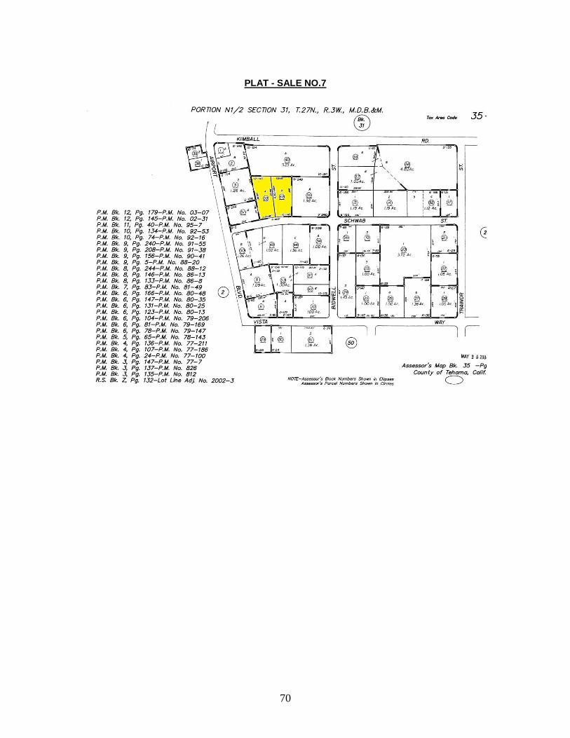
SALE NO.7 EVANS APPRAISAL SERVICE, INC.
County: Tehama Sale Number: 2020COM00059
Use: Industrial Exposure Time: 108 DOM
Location: 1530 & 1520 1540 & 1550 Schwab Street, Red Bluff
MLS: 20191239
SALE DATA:
Grantor: COLLIVER D F & C 1999 TRUST
Grantee: MISCKE LLC
Document: 2020-343 Recorded: 1/10/2020
APN: 035-490-060; 059 Zoning: Light Industrial
Transfer Tax: $1,430.00 Full Value Indicated Equity: $1,300,000
Confirmed Price: $1,300,000 Confirmed By: Corwyn Sheridan
SP Adjustment: None noted. Confirmed With: Public Records/Shane Budden 520-2770/Ken Robison 527-1111
Terms: Cash sale.

72
PROPERTY DATA:
Gross Ac: 1.97 L/B Ratio: 3.58 /1 Topography: Level
Buildings and Improvement
Description Comments Age Cond Size (SF)
Class St Un
Industrial buildings 4 buildings each has a total of 6,000 SF. 1,500 SF office
balance of buildings is warehouse areas.
2004 Average 24,000 S 1 4
Description Size (SF) RCN Contrib RCN %
Industrial buildings 24,000 $1,200,000 $750,000 62.50%
Totals $1,200,000 $750,000 62.50%
$/Sq.Ft (building only) $31.25
$/Sq.Ft (land & building) $54.17
$/Sq.Ft (land only) $6.41
$/Acre (Land only) $279,187.80
INCOME ANALYSIS:
Type of Operation: Industrial
Potential Gross Income: $184,596 Vacancy Rate: 25% / ($46,149)
Effective Gross Income: $138,447 Total Expenses: $20,767 / (15.00%)
Net Op Income : $117,680 Ro: 9.05%
GIM: 7.04 EGIM: 9.39
Other Information: Unit 1-6,000sf, $4421/month, Unit 2-6,000sf, Vacant (at owners choice-owner used it as a yard sale area), Long Term leases, Tenant paid expenses; the other 12,000 SF building has the following: Unit 1-6000sf, $2,800/month; Unit 2-6,000sf, $3823/mo.
COMPANY INFORMATION:
Appraiser: Michael H. Evans, FASA, FRICS
Analysis: Considering the land to building ratio versus the better infill of this sale compared to the subject, this sale is deemed to be only slightly inferior to the subject.

73
PLAT - SALE NO.8

74
SALE NO.8 EVANS APPRAISAL SERVICE, INC.
County: Tehama Sale Number: 2020COM00056
Use: Retail Exposure Time: 89 DOM
Location: 1055 Main Street, Red Bluff MLS: 2019-1326
SALE DATA:
Grantor: KEMEN CLIFFORD T
Grantee: CASTEEL DWAYNE E/CASTEEL BARBRA S
Document: 2020-597 Recorded: 1/17/2020
APN: 029-311-001 Zoning: City
Transfer Tax: $735.90 Full Value Indicated Equity: $669,000
Confirmed Price: $669,000 Confirmed By: Corwyn Sheridan
SP Adjustment: None noted. Confirmed With: Public Records/Max Froome 200-4655
Terms: $569,000 / PRIVATE PARTY.

75
PROPERTY DATA:
Gross Ac: 0.40 L/B Ratio: 1.64 /1 Topography: Level
Buildings and Improvement
Description Comments Age Cond Size (SF)
Class St Un
Retail and warehouse 10,660 + 1,440 mezzanine; no deferred maintenance.
Warehouse- 8,660sf (plus mezzanine), Retail- 2,000sf
1985 Average 10,660 D 1 1
Description Size (SF) RCN Contrib RCN %
Retail and warehouse 10,660 $425,000 $297,000 69.88%
Totals $425,000 $297,000 69.88%
$/Sq.Ft (building only) $27.86
$/Sq.Ft (land & building) $62.76
$/Sq.Ft (land only) $21.35
$/Acre (Land only) $930,000.00
INCOME ANALYSIS:
Type of Operation: Retail
Potential Gross Income: Not Available Vacancy Rate: 0%
Effective Gross Income: Not Available Total Expenses: Not Available
Net Op Income : Not Available Ro: Not Available
GIM: Not Available EGIM: Not Available
Other Information: Vacant at time of sale. Sellers-reallocating assets buyers-business opportunity. Was originally built as car dealership and was used as Red Bluff Auto Electric for years prior to sale. Bldg. has 3 phase power.
COMPANY INFORMATION:
Appraiser: Michael H. Evans, FASA, FRICS
Analysis: Due to the smaller size, this sale is deemed to be superior to the subject.

76
PLAT - SALE NO.9

77
SALE NO.9 EVANS APPRAISAL SERVICE, INC.
County: Tehama Sale Number: 2020COM00057
Use: Retail and industrial Exposure Time: 388 DOM
Location: 1355 Vista Way, Red Bluff MLS: 2020005595
SALE DATA:
Grantor: HELSER TIMOTHY R
Grantee: FREDE FAMILY LIVING TRUST
Document: 2020-9049 Recorded: 8/5/2020
APN: 035-500-008 Zoning: City
Transfer Tax: $330.00 Full Value Indicated Equity: $300,000
Confirmed Price: $300,000 Confirmed By: Corwyn Sheridan
SP Adjustment: None noted. Confirmed With: Public Records/Robin Fox 520-9600
Terms: Cash sale.

78
PROPERTY DATA:
Gross Ac: 1.00 L/B Ratio: 4.89 /1 Topography: Level
Buildings and Improvement
Description Comments Age Cond Size (SF)
Class St Un
Retail Industrial Average condition, no deferred maintenance.
unk Average 8,900 S 1 1
Description Size (SF) RCN Contrib RCN %
Retail Industrial 8,900 $356,000 $225,000 63.20%
Totals $356,000 $225,000 63.20%
$/Sq.Ft (building only) $25.28
$/Sq.Ft (land & building) $33.71
$/Sq.Ft (land only) $1.72
$/Acre (Land only) $75,000.00
INCOME ANALYSIS:
Type of Operation: Retail and industrial
Potential Gross Income: Not Available Vacancy Rate: 0%
Effective Gross Income: Not Available Total Expenses: Not Available
Net Op Income : Not Available Ro: Not Available
GIM: Not Available EGIM: Not Available
Other Information: Used to be a paint shop; then an auto shop. Vacant at time of sale, was an auto shop for several years before. Sellers-moved out of state; buyers-using as an investment. Located in the airport business industrial park.
COMPANY INFORMATION:
Appraiser: Michael H. Evans, FASA, FRICS
Analysis: Due to the inferior location, this sale is deemed to be inferior to the subject.

PLAT – SALE NO.10

SALE NO.10 EVANS APPRAISAL SERVICE, INC.
County: Tehama Sale Number: 2021COM00013
Use: Retail and industrial Exposure Time: Not Available
Location: 22690 and 22686 Antelope Blvd, Red Bluff
MLS: Not Available
SALE DATA:
Grantor: Stan Neitling Trust.
Grantee: Charles Geyer
Document: 2021-501 Recorded: 1/14/2021
APN: 039-312-019; 020 Zoning: C2
Transfer Tax: $1,519.10 Full Value Indicated Equity: $1,381,000
Confirmed Price: $1,381,000 Confirmed By: MHE
SP Adjustment: None noted. Confirmed With: Purchase agreement
Terms: $898,000 conventional loan obtained from WESTAMERICA BK.

PROPERTY DATA:
Gross Ac: 2.55 L/B Ratio: 4.51 /1 Topography: Level
Buildings and Improvement
Description Comments Age Cond Size (SF)
Class St Un
Retail and industrial buildings
1976 and 1995 are years built; 22690 Antelope Blvd is vacant. However 22686 Antelope Blvd is leased out to AT&T who purchased another company and then assumed the existing lease a copy of which is located in the author’s files. This lease is for a base rental rate of $3,440 per month and/or $0.26 per square foot. A large amount of remodeling was completed for the tenant, which has and is being amortized over the lease at a rate of $2,402.76 and/or $0.19 per square foot of building for a total of $0.45 per squarer foot. The lease has another three years on the original lease with the agreement having two additional five year term options. The landlord pays the property taxes and any exterior walls roof structural maintenance as well as management.
unk Fair to average
24,640 S 1 2
Description Size (SF) RCN Contrib RCN %
Retail and industrial buildings
24,640 $1,911,106 $935,000 48.92%
Totals $1,911,106 $935,000 48.92%
$/Sq.Ft (building only) $37.95
$/Sq.Ft (land & building) $56.05
$/Sq.Ft (land only) $4.02
$/Acre (Land only) $174,902.00

INCOME ANALYSIS:
Type of Operation: Retail and industrial
Potential Gross Income: $133,548 Vacancy Rate: 48% / ($64,103)
Effective Gross Income: $69,445 Total Expenses: $15,278 / (22.00%)
Net Op Income : $54,167 Ro: 3.92%
GIM: 10.34 EGIM: 19.89
Other Information: 22686 Antelope Blvd: This 12,936 square foot metal framed structure was built in 1995. This structure has a concrete slab foundation, metal siding and a straight low level gable roof design with a metal roof covering. This building was originally designed as a retail store with one main open room. However, it has been remodeled in 2016 into Flex industrial building with 18% (2,352 square feet) finished office space at the south end of the building and the rest being open warehouse storage space. The finished office space has divided wood framed sheet rocked walls, which have been taped, textured and painted. The ceilings are an acoustical tile metal suspension framed system with light fixtures strategically placed within the frame. The floor coverings are a combination of vinyl in the two bathrooms, and carpet in the offices and conference rooms. This portion of the building is centrally heated and air conditioned. Overall, this area is in good condition as of the valuation date. The north end of the building has smooth concrete unfinished floors, insulated and unfinished walls and ceiling developed for warehouse storage space with some swamp cooling and blast furnaces for heat. Overall, this section is in average condition. There are two 14’ wide roll up doors at the north end of the building for moving material in and out of the building. There is a secure fenced and paved loading and storage yard at the rear of the building. The total asphalt paving including this storage yard is 30,156 square feet. The older parking lot at the front and/or south side of the property is older and in poor condition as of the valuation date needing to be re-chipped and seal coated. The rest of the subject land, some 7,125.84 feet is undeveloped and unused land. The land to building ratio for this section of the subject property is 3.92 to 1. Overall the building was remodeled in 2016 for the new tenant for this building. 22690 Antelope Blvd: This 11,704 square foot metal framed structure was built in 1976. This structure has a concrete slab foundation, metal siding and a straight low level gable roof design with a metal roof covering. This building was originally designed as a retail store with one main open room. It has a small 392 square foot men’s and women’s bathroom and an office in the southwest corner of the building. This building has been gutted and is currently cold shelled on the inside and in fair condition. The floor is smooth concrete wall and the ceilings are insulated, but remain unfinished. Overall this building is in fair condition needing remodeling on the interior prior to a tenant or owner using this building. It is noted that the metal suspension framed system light fixtures strategically placed is still in place. At one time, some of the building had central air conditioning. Whether this still works is unknown. There is a loading dock with well at the north end of the building with one 14’ wide roll up doors at the northeast corner of the building. The total asphalt paving is 22,332 square feet. The parking lot at the front and/or south side of the property is older and in poor condition as of the valuation date needing to be re-chipped and seal coated. The rest of the subject land, some 18,074 feet is undeveloped and unused land. The land to building ratio for this section of the subject property is 4.58 to 1. Overall, this building needs remodeling and is in fair to poor condition as of the valuation date and is vacant.

COMPANY INFORMATION:
Appraiser: Michael H. Evans, FASA, FRICS
Analysis: This sale has similarities in use, vacancy and one of the buildings needing infill, with this property being slightly superior from a location standpoint.

IMPROVED SALES ANALYSIS After analyzing the improved sales, the following was concluded:
Improved Sales Chart SALE# ADDRESS SALE
PRICE SALE DATE ACRES BUILDINGSQFT
(Total) $/ SF LAND & BLDG
CAP RATE
COMMENTS
6 755 Walnut St $2,525,000 12/17/2018 0.96 9,026 $279.75 NA Superior
7 1530 & 1520 1540 & 1550 Schwab Street
$1,300,000 1/10/2020 1.97 24,000 $54.17 9.05% Inferior
8 1055 Main Street
$669,000 1/17/2020 0.40 10,660 $62.76 NA Superior
9 1355 Vista Way
$300,000 8/5/2020 1.00 8,900 $33.71 NA Inferior
10 22690 and 22686 Antelope Blvd
$1,381,000 1/14/2021 2.55 24,640 $56.05 3.92% Superior
The subject property is an averagely maintained facility, which has a good location being on
Solano Street and being surrounded by commercial and retail uses, with good access and
good parking amenities. In analyzing the researched market sales, the value of the subject is
bracketed between Sale Seven and Sale Ten. These comparable sales indicated a tight range
of $54.17 to $56.05 per square foot of building. Considering the location and condition, an
overall value of $55.00 per square foot of building is considered appropriate for the property
being appraised in its As Is condition, which takes into account the infill needed on the vacant
suite of the subject, along with also noting that Sale ten had similar conditions and dynamics
with one of its largest suite needing infill, as well as being vacant.
The value opinion of the subject property, via the Sales Comparison Approach to value -
Improved is as follows:
Sales Comparison Approach to Value – As Is - Improved:
26,590 SF x $55.00 = $1,462,000 (Rounded)
SALES COMPARISON APPROACH TO VALUE-IMPROVED……….……………..$1,462,000

COST APPROACH TO VALUE
The Cost Approach to value estimates the replacement cost new of the improvements and
deducts the appropriate depreciation to arrive at the present value of the improvements. The
land value is then added to the depreciated value of the improvements for a total value from
the Cost Approach to value.
In analyzing the subject property's improvements, the author relied on his own experience in
the building cost industry, as well as relying on the guidelines set forth by the Marshall Swift
Cost Handbook, a nationally recognized firm with over 50 years of experience in the building
cost industry in developing the Comparative Unit Method.
In estimating the depreciation, it is noted that there are three forms of depreciation. They are
physical deterioration, functional obsolescence, and external obsolescence. A description of
all three forms of depreciation follows:
Physical deterioration is a form of depreciation and is the loss in value resulting from wear and
tear in operation and exposure to the elements.
Functional obsolescence is a loss in value caused by factors inherent within a building or
building equipment unit, such as changes in construction materials and techniques, which
result in excess capital costs in existing facilities, lack of full use of space, and inability to
expand or update the property.
External obsolescence is an incurable loss in value caused by negative influences outside the
property itself, such as general economic conditions, availability of financing, or inharmonious
property uses.
It is noted that the subject property suffers only from physical depreciation. To estimate the
physical depreciation, the author utilized the effective Age-Life method. This method uses the
typical life expectancy of an improvement and the effective age of said improvement to
estimate the amount of depreciation present.

The life expectancy tables from the Handbook estimates the total economic lifespan of the
subject’s buildings at 45 to 50 years. As of the valuation date, the author observed some
physical deterioration of the subject’s improvements and estimated the effective age of the
improvements at 20 to 40 years. Therefore, the remaining economic life for the subject
property is at a range of 5 to 25 years depending upon the maintenance received. The
balance of the other components of the subject will be handled on a case by case basis. The
Comparative Unit Method of the Cost Approach to value is as follows:
Cost Approach to Value
Description of Improvements Size $Per Unit
Cost New Eff. Age
Econ Span
% Dep.
Dep. Depreciated
Value
2020 Solano Street 12,840 $89.24 $1,145,890 25 45 55.56% $636,605 $509,284
covered walkway 720 $17.13 $12,337 25 45 55.56% $6,854 $5,483
Dock 300 $28.56 $8,567 25 45 55.56% $4,760 $3,808
Loading well 1,095 $11.42 $12,508 25 45 55.56% $6,949 $5,559
Lean To 270 $19.99 $5,397 25 45 55.56% $2,999 $2,399
2026 Solano Street 11,875 $89.24 $1,059,770 20 45 44.44% $471,009 $588,761
Open Storage 540 $25.70 $13,879 20 45 44.44% $6,169 $7,711
covered walkway 500 $17.13 $8,567 20 45 44.44% $3,808 $4,760
2046 Solano Street 1,875 $128.26 $240,479 40 50 80.00% $192,383 $48,096
Metal Canopy 1,875 $39.25 $73,589 40 50 80.00% $58,871 $14,718
Gravel Paved Parking 40,809 $0.71 $29,136 25 30 83.33% $24,280 $4,856
Parking Lot & Landscaped Areas
103,502 $5.71 $591,161 20 30 66.67% $394,108 $197,054
BUILDINGS TOTAL $3,201,282 $1,808,794 $1,392,488
Rounded to $1,392,000
Add Land Value $524,000
Total $1,916,000
COST APPROACH TO VALUE – AS-IS: $1,916,000

INCOME APPROACH TO VALUE
The Income Approach to value is that value which a typical purchaser would be willing to pay
for a property based upon its income producing capability.
In order to establish an economic rental rate for the subject property, the author of this report
researched and inserted the following rent survey, which contains income information from
leased historical comparables from competitive neighborhoods to the subject. This
summarized survey is as follows:
Retail Rent comparables
ADDRESS RENT RATE
RENT DATE
LEASED SF
TYPE OF BLDG.
LEASE COMMENTS
1530 & 1520 1540 & 1550
Schwab Street, Red Bluff
$0.46 to $0.73
2020 18,000 Retail and Industrial
Modified Gross
Unit 1-6,000sf, $4421/month, Unit 2-6,000sf, Vacant (at
owner’s choice-owner used it as a yard sale area), Long Term
leases, Tenant paid expenses; the other 12,000 SF building has
the following: Unit 1-6000sf, $2,800/month; Unit 2-6,000sf,
$3823/mo.
1065 S Main St, Red Bluff
$2.54 10/2020-10/2035
2,784 Retail NNN Retail Market Broker indicated this was high rent
434 Walnut Street, Red Bluff
$0.74 7/12/1905 860 Retail Modified Gross
Salon, month to month, modified gross basis, $639, 860sf LL paid taxes and insurance (salon has
since closed)
320-420 S Main St, Red Bluff
$0.75 12/2018- 3 year lease
531 Retail Modified Gross
General Merchandise Stores
620-680 Edith Ave, Corning (Olive Tree
Plaza)
$1.5 2/2019-present
1,200 Retail NNN Retail suite
965 W Highway 99 (Bldg 1),
Corning
$1.00 10/2019- 3 year lease (had been vacant 86 months)
2,000 Retail NNN Retail suite; had to drop the asking rent to $1.00 to attract a
tenant
965 W Highway 99 (Bldg 1),
Corning
$1.10 12/2018-1 year
1,000 Office/Retail NNN Commercial suite
955 W Highway 99 (Bldg 2),
Corning STE 115
$1.75 3/1/2020- 1year lease
3,000 Retail NNN Tenant Pays All
955 W Highway 99 (Bldg 2),
Corning STE 119
$1.50 10/2019- 3 year lease (had been vacant 86
months prior to lease
3,000 Retail NNN Tenant Pays All

The leased comparables indicated a range of $0.46 per square foot per month to $2.54 per
square foot per month, on a variety of NNN and Modified Gross basis. Noting that the range is
higher than what the subject is commanding, however, also observing the slowdown that is
starting to be observed in the retail sector, most likely due to the impact of COVID, the existing
and asking rates of the subject at $0.26 to $0.33 per square foot per month on modified net
basis mostly is deemed to be economic for the subject. Note that an adjustment of $4.00 per
Square Foot will have to be applied to this approach in in order to account for the TI’s
previously discussed. Note that this attractive offer would reduce the vacancy of the subject to
an estimated 2.00%, and even though the rent will be low the first year, such an endeavor
would, at the end, and after the first year, yield a positive cash flow. This is all based on the
information presented to the author.
The concluded existing and asking rates of the subject would indicate a potential gross income
for this property. Once the potential gross income is established, a rent loss and vacancy
factor is deducted. This loss is caused by tenant turnover or lack of payment by the tenants
and/or vacant units. Due to the location and the nature of the subject property, a vacancy and
rent loss factor of 2.00% was estimated and considered to be appropriate, also based on the
discount established for the largest suite, which at the offered TI’s rate, should have no
problem being absorbed quickly by the market. Deducting the rent loss and vacancy from the
property indicates an annual effective gross income for the subject property.
From the Effective Gross Income are then deducted the typical expenses that a landlord would
incur. Based on the rent comparables, properties like the subject property are typically rented
on a variety of leases; considering the existing and asking agreements of the subject, a
modified NNN type of lease is warranted. This indicates that the landlord will incur minimal
expenses such as taxes, exterior maintenance and management. Taxes will be estimated by
loading the tax rate into an appropriate capitalization rate.
Deducting these expenses from the Effective gross income indicates a residual commonly
called the Net Income. The Net Income is then capitalized at a Rate of Return acceptable to
the market.

Therefore, the last step needed in developing the Income Approach to value would be to
develop an appropriate capitalization rate for the subject property.
In determining an appropriate capitalization rate for the subject, it was noted that the market
sales analyzed in the Sales Comparison Approach provided a range of 3.95% to 9.05%.
Relying on this range, and mostly on the one indicated by Sale 10, a rate of 3.95% is
warranted for the subject property. The Income Approach to value for the subject property is
developed as follows:
Income Approach to Value
SF Monthly
Rate/$/SF Monthly
Rate
2020 Solano Street 12,840 $0.33 $4,237.20 $50,846
2026 Solano Street 11,875 $0.26 $3,100.00 $37,200
2046 Solano Street 1,875 $0.32 $600.00 $7,200
Potential Gross Income: $95,246
Less Rent Loss & Vacancy Factory 2.00% $1,905
Effective Gross Income: $93,341
Less Expenses
Taxes Estimated by loading tax rate into cap rate
Maintenance 3.00% $2,800
Management 8.00% $7,467
Total Expenses: $10,267
Net Operating Income: $83,074
Tax Rate 1.311200%
Capitalization Rate 3.95%
Loaded Rate 5.26%
Indicated value from the Income Approach $1,578,992
Less TI's $51,360
Totaled and Rounded To $1,528,000

RECONCILIATION OF VALUES
The values, as indicated by the three approaches to value, are as follows:
SALES COMPARISON APPROACH $1,462,000 COST APPROACH $1,916,000 INCOME APPROACH $1,528,000
The Sales Comparison Approach to Value is typically a good indicator of value when one has
numerous sales of similar types of properties. The author used the best comparable sales that
he could find in the surrounding area. Overall, this approach seems to reflect a direct range of
values for properties of the subject’s type, and therefore, considerable weight is placed upon it
in arriving at a fair market value for the subject property.
The Cost Approach to Value is typically a good indicator of value when one has a newer
building with accurate estimates of construction costs, land values, estimates of depreciation,
and a strong market. There also needs to be a purchaser willing to pay replacement costs less
depreciation for the improvements on the property. Considering the age and condition of the
subject property’s improvements, less weight is placed on this approach.
The Income Approach to Value is typically a good indicator of value on an income producing
property, which is bought on a rate of return a typical investor would be willing to accept. The
subject property’s income was estimated based on market and this approach appears to be
credible in the valuation of the subject property. Overall, some weight is placed upon this
approach to value.
After analyzing all three approaches to value, and placing weight on the Sales Comparison
Approach and the Income Approach, the author’s opinion of the Fair Market Value for the
subject property is concluded as follows:
FAIR MARKET VALUE…..…………………………$1,500,000

CERTIFICATION OF REPORT
The appraiser hereby certifies: The statements of fact contained in this report are true and correct. The reported analysis, opinions, and conclusions are limited only by the reported assumptions and limiting conditions, and are my personal, unbiased professional analysis, opinions, and conclusions. I have no present or prospective interest in the property that is the subject of this report, and I have no personal interest or bias with respect to the parties involved. My compensation is not contingent on an action or event resulting from the analysis, opinions, conclusions in, or the use of this report. My compensation is not contingent upon the reporting of a predetermined value or direction in value that favors the cause of the client, the amount of the value estimate, the attainment of a stipulated result, or the occurrence of a subsequent event. That this appraisal assignment is not based on a requested minimum valuation, a specific valuation, or the approval of a loan. My analysis, opinions, and conclusions were developed, and this report has been prepared, in conformity with the Uniform Standards of Professional Appraisal Practice, the requirements of the Code of Professional Ethics and Standards of Professional Practice of the Royal Institution of Chartered Surveyors and the American Society of Appraisers. The use of this report is subject to the requirements of the Royal Institution of Chartered Surveyors and the American Society of Appraisers of Real Estate Appraisers relating to review by its duly authorized representatives. I have made a personal inspection of the property that is the subject of this report. I have performed no services, as an appraiser or in any other capacity, regarding the property that is the subject of this report within the three-year period immediately preceding acceptance of this assignment.

Evans Appraisal Service, Inc. Michael H. Evans, FASA / FRICS Page 2 I do not authorize the out-of-context quoting from or partial reprinting of this appraisal report. Further, neither all nor any part of this appraisal report shall be disseminated to the general public by the use of media for public communication without the prior written consent of the appraiser signing this appraisal. Michael H. Evans has successfully completed the requirements set forth by the State of California for licensing and certification, and has been awarded the Certified General Real Estate Appraiser Certificate No. AG002019. That in his opinion, the Fair Market Value of the subject property, as of the valuation date of April 7, 2021, is as follows:
FAIR MARKET VALUE…..…………………………….$1,500,000
Respectfully submitted,
____________________________ Michael H. Evans, FASA, FRICS California State Certified General Real Estate Appraiser #AG002019 Recertified until October 28, 2022

SALES SUMMARY
Land Sales Chart
SALE# SALE DATE
ADDRESS SALE PRICE
ACRES $/ SF LAND ONLY
COMMENTS
1 12/20/2017 South Ave $700,000 8.75 $1.84 Inferior
2 1/30/2018 0 Hwy 99 W $60,000 1.69 $0.82 Inferior
3 11/5/2018 3129 S Highway 99W
$90,000 2.50 $0.83 Inferior
4 7/3/2019 SE Corner of Highway 99W and Fig Ln
$170,000 1.96 $1.99 Inferior
5 2/16/2021 1905 Solano St
$49,000 0.18 $6.25 Superior
Improved Sales Chart
SALE# ADDRESS SALE PRICE
SALE DATE ACRES BUILDINGSQFT (Total)
$/ SF LAND & BLDG
CAP RATE
COMMENTS
6 755 Walnut St $2,525,000 12/17/2018 0.96 9,026 $279.75 NA Superior
7 1530 & 1520 1540 & 1550 Schwab Street
$1,300,000 1/10/2020 1.97 24,000 $54.17 9.05% Inferior
8 1055 Main Street
$669,000 1/17/2020 0.40 10,660 $62.76 NA Superior
9 1355 Vista Way
$300,000 8/5/2020 1.00 8,900 $33.71 NA Inferior
10 22690 and 22686 Antelope Blvd
$1,381,000 1/14/2021 2.55 24,640 $56.05 3.92% Superior

LAND SALES MAP

COMMERCIAL SALES

LEGAL DESCRIPTION


REFERENCES 1) American Institute of Real Estate Appraisers, The Dictionary of Real Estate Appraisal,
3rd Edition, (Chicago 1993) page 140 and 171. 2) 1987 National Survey of Buying Power of Metropolitan Areas, Sales and Marketing
Magazine, pages B-29. 3) The Appraisal of Real Estate, 12th Edition, page 336 4) Uniform Standards of Professional Appraisal Practice (USPAP), 2020-2021 Edition
REFERENCES/PHOTOS: 5) YCPD.ORG
6) CITY-DATA.COM
7) GREATSCHOOLS.NET
8) SYIX.COM
9) DOF.CA.GOV
10) WEBSHOTS.COM
11) REFERENCES/PHOTOS:
12) CALMIS.CA.GOV
13) DOF.CA.GOV
14) ADUNNPHOTOGRAPHY.OM
15) BOE.CA.GOV
16) GREATSCHOOLS.NET
17) CITY-DATA.COM
18) WEBSHOTS.COM