approved jurisdictional determination form u.s. army corps ... · approved jurisdictional...
TRANSCRIPT
1
APPROVED JURISDICTIONAL DETERMINATION FORM U.S. Army Corps of Engineers
SECTION I: BACKGROUND INFORMATION A. REPORT COMPLETION DATE FOR APPROVED JURISDICTIONAL DETERMINATION (JD): 10 JAN 17 B. DISTRICT OFFICE, FILE NAME, AND NUMBER: Chicago District, LRC-2010-518 C. PROJECT LOCATION AND BACKGROUND INFORMATION:
State: Illinois County/parish/borough: Lake City: Wadsworth, Zion, Beach Park Center coordinates of site (lat/long in degree decimal format): Lat. 42.47°N, Long. -87.88° W. Universal Transverse Mercator: Zone 16 Name of nearest waterbody: East Fork Tributary of Des Plaines River Name of nearest Traditional Navigable Water (TNW) into which the aquatic resource flows: Des Plaines River Name of watershed or Hydrologic Unit Code (HUC): Des Plaines (07120004)
Check if map/diagram of review area and/or potential jurisdictional areas is/are available upon request. Check if other sites (e.g., offsite mitigation sites, disposal sites, etc…) are associated with this action and are recorded on a
different JD form. D. REVIEW PERFORMED FOR SITE EVALUATION (CHECK ALL THAT APPLY):
Office (Desk) Determination. Date: 10/25/16 Field Determination. Date(s): 9/4/15, 12/10/15
SECTION II: SUMMARY OF FINDINGS A. RHA SECTION 10 DETERMINATION OF JURISDICTION. There Are no “navigable waters of the U.S.” within Rivers and Harbors Act (RHA) jurisdiction (as defined by 33 CFR part 329) in the review area. [Required]
Waters subject to the ebb and flow of the tide. Waters are presently used, or have been used in the past, or may be susceptible for use to transport interstate or foreign commerce.
Explain: Defined in People of State of Ill. ex rel. Scott v. Hoffman, No. P-CIV-76-45, slip op. at 7 (S.D.Ill. Jan. 20, 1979). B. CWA SECTION 404 DETERMINATION OF JURISDICTION. There Pick List “waters of the U.S.” within Clean Water Act (CWA) jurisdiction (as defined by 33 CFR part 328) in the review area. [Required] 1. Waters of the U.S. a. Indicate presence of waters of U.S. in review area (check all that apply): 1 TNWs, including territorial seas Wetlands adjacent to TNWs Relatively permanent waters2 (RPWs) that flow directly or indirectly into TNWs Wetlands directly abutting RPWs that flow directly or indirectly into TNWs
b. Identify (estimate) size of waters of the U.S. in the review area: Non-wetland waters: linear feet: width (ft) and/or Site W4 = 0.01, Site W5 = 0.04 acres. Wetlands: Site 7 = 0.18, Site 8 = 0.14, Site 9 = 0.25, Site 65 = 1.69 acres. c. Limits (boundaries) of jurisdiction based on: 1987 Delineation Manual Elevation of established OHWM (if known): . SECTION III: CWA ANALYSIS A. TNWs AND WETLANDS ADJACENT TO TNWs The agencies will assert jurisdiction over TNWs and wetlands adjacent to TNWs. If the aquatic resource is a TNW, complete
Section III.A.1 and Section III.D.1. only; if the aquatic resource is a wetland adjacent to a TNW, complete Sections III.A.1 and 2 and Section III.D.1.; otherwise, see Section III.B below.
1. TNW Identify TNW: Pick List.
Summarize rationale supporting determination: As defined in People of State of Ill. ex rel. Scott v. Hoffman, No. P-CIV-76-45, slip op. at 7 (S.D.Ill. Jan. 20, 1979).
2. Wetland adjacent to TNW Summarize rationale supporting conclusion that wetland is “adjacent”: .
1 Boxes checked below shall be supported by completing the appropriate sections in Section III below. 2 For purposes of this form, an RPW is defined as a tributary that is not a TNW and that typically flows year-round or has continuous flow at least “seasonally” (e.g., typically 3 months).
2
D. DETERMINATIONS OF JURISDICTIONAL FINDINGS. THE SUBJECT WATERS/WETLANDS ARE (CHECK ALL
THAT APPLY):
1. TNWs and Adjacent Wetlands. Check all that apply and provide size estimates in review area: TNWs: linear feet width (ft), Or, acres. Wetlands adjacent to TNWs: acres.
2. RPWs that flow directly or indirectly into TNWs.
Tributaries of TNWs where tributaries typically flow year-round are jurisdictional. Provide data and rationale indicating that tributary is perennial: .
Tributaries of TNW where tributaries have continuous flow “seasonally” (e.g., typically three months each year) are jurisdictional. Data supporting this conclusion is provided at Section III.B. Provide rationale indicating that tributary flows seasonally: Site W4 was behind a fence and could not be observed. Aerial photos from 2015 show a clearly defined flow route SW to W5. W5 directly flows into the wetlands and the off-site tributary East Fork Des Plaines River Tributary (EFDRT) EFDRT is a solid blue line on the USGS map and flows directly to the Des Plaines River, which is an RPW in the area and becoms a TNW downstream.
Provide estimates for jurisdictional waters in the review area (check all that apply): Tributary waters: W4 = 20, W5 = 60 linear feet W4 = 1, W5 = 2 width (ft). Other non-wetland waters: acres.
Identify type(s) of waters: .
4. Wetlands directly abutting an RPW that flow directly or indirectly into TNWs. Wetlands directly abut RPW and thus are jurisdictional as adjacent wetlands. Wetlands directly abutting an RPW where tributaries typically flow year-round. Provide data and rationale indicating that tributary is perennial in Section III.D.2, above. Provide rationale indicating that wetland is directly abutting an RPW: . Wetlands directly abutting an RPW where tributaries typically flow “seasonally.” Provide data indicating that tributary is
seasonal in Section III.B and rationale in Section III.D.2, above. Provide rationale indicating that wetland is directly abutting an RPW: Site 7 is directly abutting site W4 based on site observations and aerial photos. Site 9 drains directly into W5 which then flows directly into Site 8, based on site observations and aerial photos. Site 65 is located on either side of Taylor Lane and continues off-site based on site obsevations, aerial photos, flood or record mapping, local county wetland mapping and connects directly to (is abutting) the off-site EFDRT.
Provide acreage estimates for jurisdictional wetlands in the review area: Site 7 = 0.18, Site 8 = 0.14, Site 9 = 0.25, Site 65 = 1.69
acres. SECTION IV: DATA SOURCES. A. SUPPORTING DATA. Data reviewed for JD (check all that apply - checked items shall be included in case file and, where checked
and requested, appropriately reference sources below): Maps, plans, plots or plat submitted by or on behalf of the applicant/consultant: . Data sheets prepared/submitted by or on behalf of the applicant/consultant.
Office concurs with data sheets/delineation report. Office does not concur with data sheets/delineation report.
Data sheets prepared by the Corps: . Corps navigable waters’ study: . U.S. Geological Survey Hydrologic Atlas: Waukegan HA 234, 1967, .
USGS NHD data. USGS 8 and 12 digit HUC maps.
U.S. Geological Survey map(s). Cite scale & quad name: Waukegan 7.5", 1993, Pick List, Pick List, . USDA Natural Resources Conservation Service Soil Survey. Citation: Soil Survey of Lake County, Illinois (2005). National wetlands inventory map(s). Cite name: Waukegan, . State/Local wetland inventory map(s): Lake County ADID, Pick List, . FEMA/FIRM maps: . 100-year Floodplain Elevation is: (National Geodetic Vertical Datum of 1929) Photographs: Aerial (Name & Date): Google Earth, Lake County GIS online mapping tool.
or Other (Name & Date): . Previous determination(s). File no. and date of response letter: . Applicable/supporting case law: . Applicable/supporting scientific literature: . Other information (please specify): .
B. ADDITIONAL COMMENTS TO SUPPORT JD: .
1
APPROVED JURISDICTIONAL DETERMINATION FORM U.S. Army Corps of Engineers
This form should be completed by following the instructions provided in Section IV of the JD Form Instructional Guidebook. SECTION I: BACKGROUND INFORMATION A. REPORT COMPLETION DATE FOR APPROVED JURISDICTIONAL DETERMINATION (JD): 10 JAN 17 B. DISTRICT OFFICE, FILE NAME, AND NUMBER: Chicago District, LRC-2010-518 C. PROJECT LOCATION AND BACKGROUND INFORMATION:
State: Illinois County/parish/borough: Lake City: Beach Park, Waukegan Center coordinates of site (lat/long in degree decimal format): Lat. 42.444°N, Long. -87.876° W. Universal Transverse Mercator: Zone 16 Name of nearest waterbody: Suburban Country Club Tributary Name of nearest Traditional Navigable Water (TNW) into which the aquatic resource flows: Des Plaines River Name of watershed or Hydrologic Unit Code (HUC): Des Plaines (07120004)
Check if map/diagram of review area and/or potential jurisdictional areas is/are available upon request. Check if other sites (e.g., offsite mitigation sites, disposal sites, etc…) are associated with this action and are recorded on a
different JD form. D. REVIEW PERFORMED FOR SITE EVALUATION (CHECK ALL THAT APPLY):
Office (Desk) Determination. Date: 10/25/16 Field Determination. Date(s): 9/4/15, 12/10/15
SECTION II: SUMMARY OF FINDINGS A. RHA SECTION 10 DETERMINATION OF JURISDICTION. There Are no “navigable waters of the U.S.” within Rivers and Harbors Act (RHA) jurisdiction (as defined by 33 CFR part 329) in the review area. [Required]
Waters subject to the ebb and flow of the tide. Waters are presently used, or have been used in the past, or may be susceptible for use to transport interstate or foreign commerce.
Explain: Defined in People of State of Ill. ex rel. Scott v. Hoffman, No. P-CIV-76-45, slip op. at 7 (S.D.Ill. Jan. 20, 1979). B. CWA SECTION 404 DETERMINATION OF JURISDICTION. There Are “waters of the U.S.” within Clean Water Act (CWA) jurisdiction (as defined by 33 CFR part 328) in the review area. [Required] 1. Waters of the U.S. a. Indicate presence of waters of U.S. in review area (check all that apply): 1 TNWs, including territorial seas Wetlands adjacent to TNWs Relatively permanent waters2 (RPWs) that flow directly or indirectly into TNWs Non-RPWs that flow directly or indirectly into TNWs Wetlands directly abutting RPWs that flow directly or indirectly into TNWs Wetlands adjacent to but not directly abutting RPWs that flow directly or indirectly into TNWs Wetlands adjacent to non-RPWs that flow directly or indirectly into TNWs Impoundments of jurisdictional waters Isolated (interstate or intrastate) waters, including isolated wetlands
b. Identify (estimate) size of waters of the U.S. in the review area: Non-wetland waters: linear feet: width (ft) and/or W6 = 0.3, W7 = 0.01 acres. Wetlands: Site 40 = 1.01, Site 41 = 0.00, Site 51 = 0.18, Site 52 = 0.13 , Site 53 = 0.04, Site 69 = 13.0, Site 70 = 8.78, Site 71 = 0.09, Site 55 = 0.06, Site 72 = 0.01 acres (Acreage listed within project boundaries. Total wetland size may be larger). c. Limits (boundaries) of jurisdiction based on: 1987 Delineation Manual Elevation of established OHWM (if known): . 2. Non-regulated waters/wetlands (check if applicable):3 Potentially jurisdictional waters and/or wetlands were assessed within the review area and determined to be not jurisdictional.
Explain: .
1 Boxes checked below shall be supported by completing the appropriate sections in Section III below. 2 For purposes of this form, an RPW is defined as a tributary that is not a TNW and that typically flows year-round or has continuous flow at least “seasonally” (e.g., typically 3 months). 3 Supporting documentation is presented in Section III.F.
2
SECTION III: CWA ANALYSIS A. TNWs AND WETLANDS ADJACENT TO TNWs The agencies will assert jurisdiction over TNWs and wetlands adjacent to TNWs. If the aquatic resource is a TNW, complete
Section III.A.1 and Section III.D.1. only; if the aquatic resource is a wetland adjacent to a TNW, complete Sections III.A.1 and 2 and Section III.D.1.; otherwise, see Section III.B below.
1. TNW Identify TNW: Pick List.
Summarize rationale supporting determination: As defined in People of State of Ill. ex rel. Scott v. Hoffman, No. P-CIV-76-45,
slip op. at 7 (S.D.Ill. Jan. 20, 1979).
2. Wetland adjacent to TNW Summarize rationale supporting conclusion that wetland is “adjacent”: .
B. CHARACTERISTICS OF TRIBUTARY (THAT IS NOT A TNW) AND ITS ADJACENT WETLANDS (IF ANY): This section summarizes information regarding characteristics of the tributary and its adjacent wetlands, if any, and it helps
determine whether or not the standards for jurisdiction established under Rapanos have been met. The agencies will assert jurisdiction over non-navigable tributaries of TNWs where the tributaries are “relatively permanent
waters” (RPWs), i.e. tributaries that typically flow year-round or have continuous flow at least seasonally (e.g., typically 3 months). A wetland that directly abuts an RPW is also jurisdictional. If the aquatic resource is not a TNW, but has year-round (perennial) flow, skip to Section III.D.2. If the aquatic resource is a wetland directly abutting a tributary with perennial flow, skip to Section III.D.4.
A wetland that is adjacent to but that does not directly abut an RPW requires a significant nexus evaluation. Corps districts and
EPA regions will include in the record any available information that documents the existence of a significant nexus between a relatively permanent tributary that is not perennial (and its adjacent wetlands if any) and a traditional navigable water, even though a significant nexus finding is not required as a matter of law.
If the waterbody4 is not an RPW, or a wetland directly abutting an RPW, a JD will require additional data to determine if the waterbody has a significant nexus with a TNW. If the tributary has adjacent wetlands, the significant nexus evaluation must consider the tributary in combination with all of its adjacent wetlands. This significant nexus evaluation that combines, for analytical purposes, the tributary and all of its adjacent wetlands is used whether the review area identified in the JD request is the tributary, or its adjacent wetlands, or both. If the JD covers a tributary with adjacent wetlands, complete Section III.B.1 for the tributary, Section III.B.2 for any onsite wetlands, and Section III.B.3 for all wetlands adjacent to that tributary, both onsite and offsite. The determination whether a significant nexus exists is determined in Section III.C below.
1. Characteristics of non-TNWs that flow directly or indirectly into TNW
(i) General Area Conditions: Watershed size: 934, 048 acres Drainage area: 836, 673 acres Average annual rainfall: 34.36 inches Average annual snowfall: 37.4 inches (ii) Physical Characteristics: (a) Relationship with TNW: Tributary flows directly into TNW. Tributary flows through 1 tributaries before entering TNW. Project waters are 30 (or more) river miles from TNW. Project waters are 1 (or less) river miles from RPW. Project waters are 30 (or more) aerial (straight) miles from TNW. Project waters are 1 (or less) aerial (straight) miles from RPW. Project waters cross or serve as state boundaries. Explain: .
4 Note that the Instructional Guidebook contains additional information regarding swales, ditches, washes, and erosional features generally and in the arid West.
3
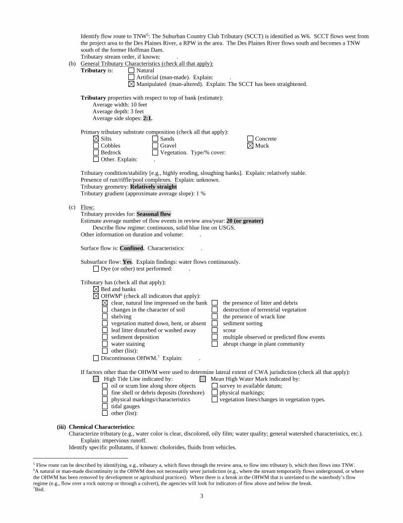
Identify flow route to TNW5: The Suburban Country Club Tributary (SCCT) is identified as W6. SCCT flows west from the project area to the Des Plaines River, a RPW in the area. The Des Plaines River flows south and becomes a TNW south of the former Hoffman Dam.
Tributary stream order, if known: . (b) General Tributary Characteristics (check all that apply): Tributary is: Natural Artificial (man-made). Explain: . Manipulated (man-altered). Explain: The SCCT has been straightened.
Tributary properties with respect to top of bank (estimate):
Average width: 10 feet Average depth: 3 feet Average side slopes: 2:1. Primary tributary substrate composition (check all that apply):
Silts Sands Concrete Cobbles Gravel Muck Bedrock Vegetation. Type/% cover: Other. Explain: . Tributary condition/stability [e.g., highly eroding, sloughing banks]. Explain: relatively stable. Presence of run/riffle/pool complexes. Explain: unknown. Tributary geometry: Relatively straight Tributary gradient (approximate average slope): 1 % (c) Flow: Tributary provides for: Seasonal flow Estimate average number of flow events in review area/year: 20 (or greater) Describe flow regime: continuous, solid blue line on USGS. Other information on duration and volume: . Surface flow is: Confined. Characteristics: . Subsurface flow: Yes. Explain findings: water flows continuously. Dye (or other) test performed: . Tributary has (check all that apply): Bed and banks OHWM6 (check all indicators that apply):
clear, natural line impressed on the bank the presence of litter and debris changes in the character of soil destruction of terrestrial vegetation shelving the presence of wrack line vegetation matted down, bent, or absent sediment sorting leaf litter disturbed or washed away scour sediment deposition multiple observed or predicted flow events water staining abrupt change in plant community other (list):
Discontinuous OHWM.7 Explain: .
If factors other than the OHWM were used to determine lateral extent of CWA jurisdiction (check all that apply): High Tide Line indicated by: Mean High Water Mark indicated by:
oil or scum line along shore objects survey to available datum; fine shell or debris deposits (foreshore) physical markings; physical markings/characteristics vegetation lines/changes in vegetation types. tidal gauges other (list):
(iii) Chemical Characteristics:
Characterize tributary (e.g., water color is clear, discolored, oily film; water quality; general watershed characteristics, etc.). Explain: impervious runoff.
Identify specific pollutants, if known: cholorides, fluids from vehicles.
5 Flow route can be described by identifying, e.g., tributary a, which flows through the review area, to flow into tributary b, which then flows into TNW. 6A natural or man-made discontinuity in the OHWM does not necessarily sever jurisdiction (e.g., where the stream temporarily flows underground, or where the OHWM has been removed by development or agricultural practices). Where there is a break in the OHWM that is unrelated to the waterbody’s flow regime (e.g., flow over a rock outcrop or through a culvert), the agencies will look for indicators of flow above and below the break. 7Ibid.

4
(iv) Biological Characteristics. Channel supports (check all that apply): Riparian corridor. Characteristics (type, average width): over 100 feet in many stretches with large stretches of open woodland and wtlands abutting the stream. Wetland fringe. Characteristics: large wetland fringes in some areas, narrow in others. Habitat for:
Federally Listed species. Explain findings: . Fish/spawn areas. Explain findings: . Other environmentally-sensitive species. Explain findings: . Aquatic/wildlife diversity. Explain findings: very respectable natural (maniupulated) corrdior around much of the stream corridor. 2. Characteristics of wetlands adjacent to non-TNW that flow directly or indirectly into TNW
(i) Physical Characteristics: (a) General Wetland Characteristics: Properties: Wetland size: 1.08 acres Wetland type. Explain: PEM. Wetland quality. Explain: Sites 40 is moderate to high quality and of suffiecent size to have more significant benefits for habitat, flood retention, water quality improvement. Sites 55 and 72 are low quality but provide water quality and water retention functions. Project wetlands cross or serve as state boundaries. Explain: .
(b) General Flow Relationship with Non-TNW: Flow is: Intermittent flow. Explain: Sites 40 flows along Wadsworth Road to west to SCCT, mostly during rain events. Site 55 and 72 are connected and water flows from Site 55 into a culvert that conveys water west into a open ditch that continues north (flow is intermittant to seasonal in this drainagway). Water becomes perennial further north as SCCT continues north and west. . Surface flow is: Discrete and confined Characteristics: . Subsurface flow: Unknown. Explain findings: . Dye (or other) test performed: . (c) Wetland Adjacency Determination with Non-TNW:
Directly abutting Not directly abutting Discrete wetland hydrologic connection. Explain: . Ecological connection. Explain: . Separated by berm/barrier. Explain: . (d) Proximity (Relationship) to TNW
Project wetlands are 30 (or more) river miles from TNW. Project waters are 30 (or more) aerial (straight) miles from TNW.
Flow is from: Wetland to navigable waters. Estimate approximate location of wetland as within the 50 - 100-year floodplain. (ii) Chemical Characteristics:
Characterize wetland system (e.g., water color is clear, brown, oil film on surface; water quality; general watershed characteristics; etc.). Explain: water is clear.
Identify specific pollutants, if known: road salt, grease, oil. (iii) Biological Characteristics. Wetland supports (check all that apply): Riparian buffer. Characteristics (type, average width): . Vegetation type/percent cover. Explain: . Habitat for:
Federally Listed species. Explain findings: . Fish/spawn areas. Explain findings: .
Other environmentally-sensitive species. Explain findings: . Aquatic/wildlife diversity. Explain findings: .
3. Characteristics of all wetlands adjacent to the tributary (if any) All wetland(s) being considered in the cumulative analysis: 4 Approximately ( 1.08 ) acres in total are being considered in the cumulative analysis.
5
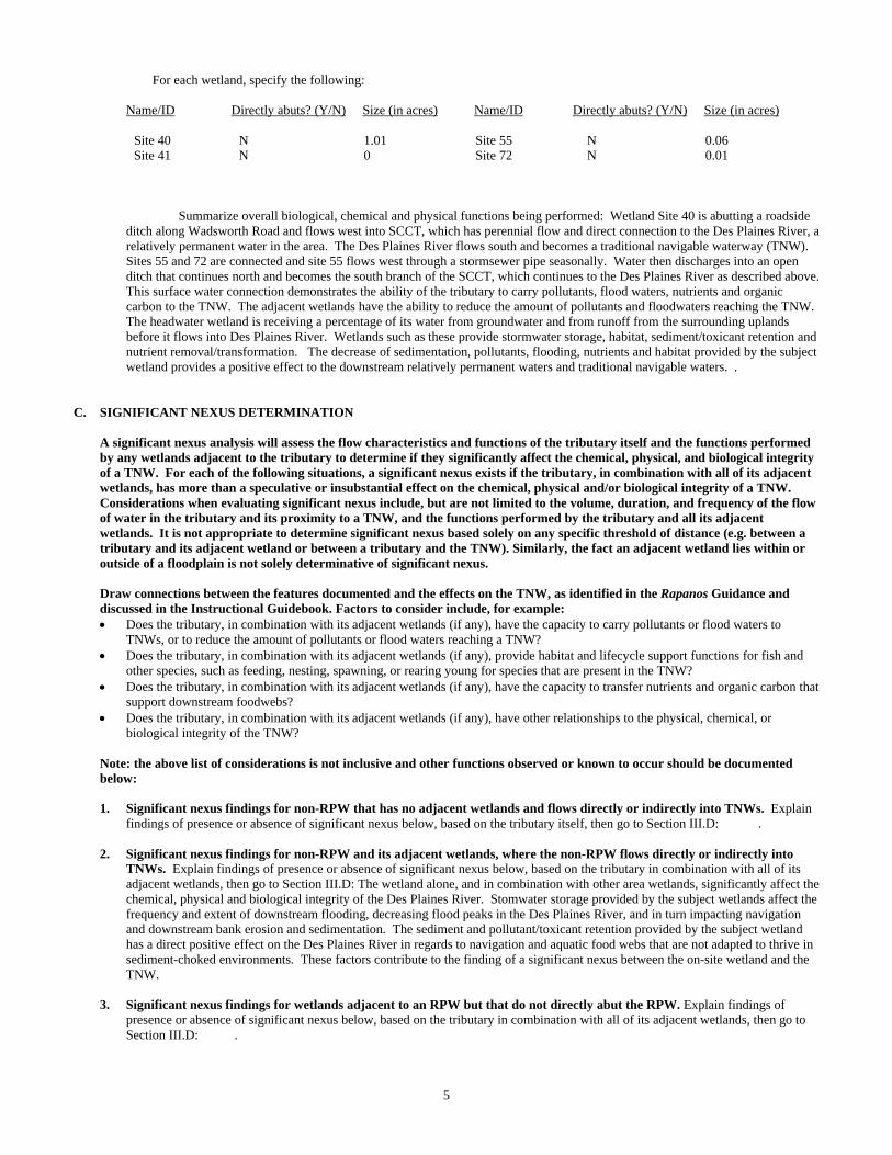
For each wetland, specify the following: Name/ID Directly abuts? (Y/N) Size (in acres) Name/ID Directly abuts? (Y/N) Size (in acres)
Site 40 N 1.01 Site 55 N 0.06 Site 41 N 0 Site 72 N 0.01
Summarize overall biological, chemical and physical functions being performed: Wetland Site 40 is abutting a roadside
ditch along Wadsworth Road and flows west into SCCT, which has perennial flow and direct connection to the Des Plaines River, a relatively permanent water in the area. The Des Plaines River flows south and becomes a traditional navigable waterway (TNW). Sites 55 and 72 are connected and site 55 flows west through a stormsewer pipe seasonally. Water then discharges into an open ditch that continues north and becomes the south branch of the SCCT, which continues to the Des Plaines River as described above. This surface water connection demonstrates the ability of the tributary to carry pollutants, flood waters, nutrients and organic carbon to the TNW. The adjacent wetlands have the ability to reduce the amount of pollutants and floodwaters reaching the TNW. The headwater wetland is receiving a percentage of its water from groundwater and from runoff from the surrounding uplands before it flows into Des Plaines River. Wetlands such as these provide stormwater storage, habitat, sediment/toxicant retention and nutrient removal/transformation. The decrease of sedimentation, pollutants, flooding, nutrients and habitat provided by the subject wetland provides a positive effect to the downstream relatively permanent waters and traditional navigable waters. .
C. SIGNIFICANT NEXUS DETERMINATION
A significant nexus analysis will assess the flow characteristics and functions of the tributary itself and the functions performed by any wetlands adjacent to the tributary to determine if they significantly affect the chemical, physical, and biological integrity of a TNW. For each of the following situations, a significant nexus exists if the tributary, in combination with all of its adjacent wetlands, has more than a speculative or insubstantial effect on the chemical, physical and/or biological integrity of a TNW. Considerations when evaluating significant nexus include, but are not limited to the volume, duration, and frequency of the flow of water in the tributary and its proximity to a TNW, and the functions performed by the tributary and all its adjacent wetlands. It is not appropriate to determine significant nexus based solely on any specific threshold of distance (e.g. between a tributary and its adjacent wetland or between a tributary and the TNW). Similarly, the fact an adjacent wetland lies within or outside of a floodplain is not solely determinative of significant nexus. Draw connections between the features documented and the effects on the TNW, as identified in the Rapanos Guidance and discussed in the Instructional Guidebook. Factors to consider include, for example: Does the tributary, in combination with its adjacent wetlands (if any), have the capacity to carry pollutants or flood waters to
TNWs, or to reduce the amount of pollutants or flood waters reaching a TNW? Does the tributary, in combination with its adjacent wetlands (if any), provide habitat and lifecycle support functions for fish and
other species, such as feeding, nesting, spawning, or rearing young for species that are present in the TNW? Does the tributary, in combination with its adjacent wetlands (if any), have the capacity to transfer nutrients and organic carbon that
support downstream foodwebs? Does the tributary, in combination with its adjacent wetlands (if any), have other relationships to the physical, chemical, or
biological integrity of the TNW? Note: the above list of considerations is not inclusive and other functions observed or known to occur should be documented
below: 1. Significant nexus findings for non-RPW that has no adjacent wetlands and flows directly or indirectly into TNWs. Explain
findings of presence or absence of significant nexus below, based on the tributary itself, then go to Section III.D: . 2. Significant nexus findings for non-RPW and its adjacent wetlands, where the non-RPW flows directly or indirectly into
TNWs. Explain findings of presence or absence of significant nexus below, based on the tributary in combination with all of its adjacent wetlands, then go to Section III.D: The wetland alone, and in combination with other area wetlands, significantly affect the chemical, physical and biological integrity of the Des Plaines River. Stomwater storage provided by the subject wetlands affect the frequency and extent of downstream flooding, decreasing flood peaks in the Des Plaines River, and in turn impacting navigation and downstream bank erosion and sedimentation. The sediment and pollutant/toxicant retention provided by the subject wetland has a direct positive effect on the Des Plaines River in regards to navigation and aquatic food webs that are not adapted to thrive in sediment-choked environments. These factors contribute to the finding of a significant nexus between the on-site wetland and the TNW.
3. Significant nexus findings for wetlands adjacent to an RPW but that do not directly abut the RPW. Explain findings of
presence or absence of significant nexus below, based on the tributary in combination with all of its adjacent wetlands, then go to Section III.D: .
6
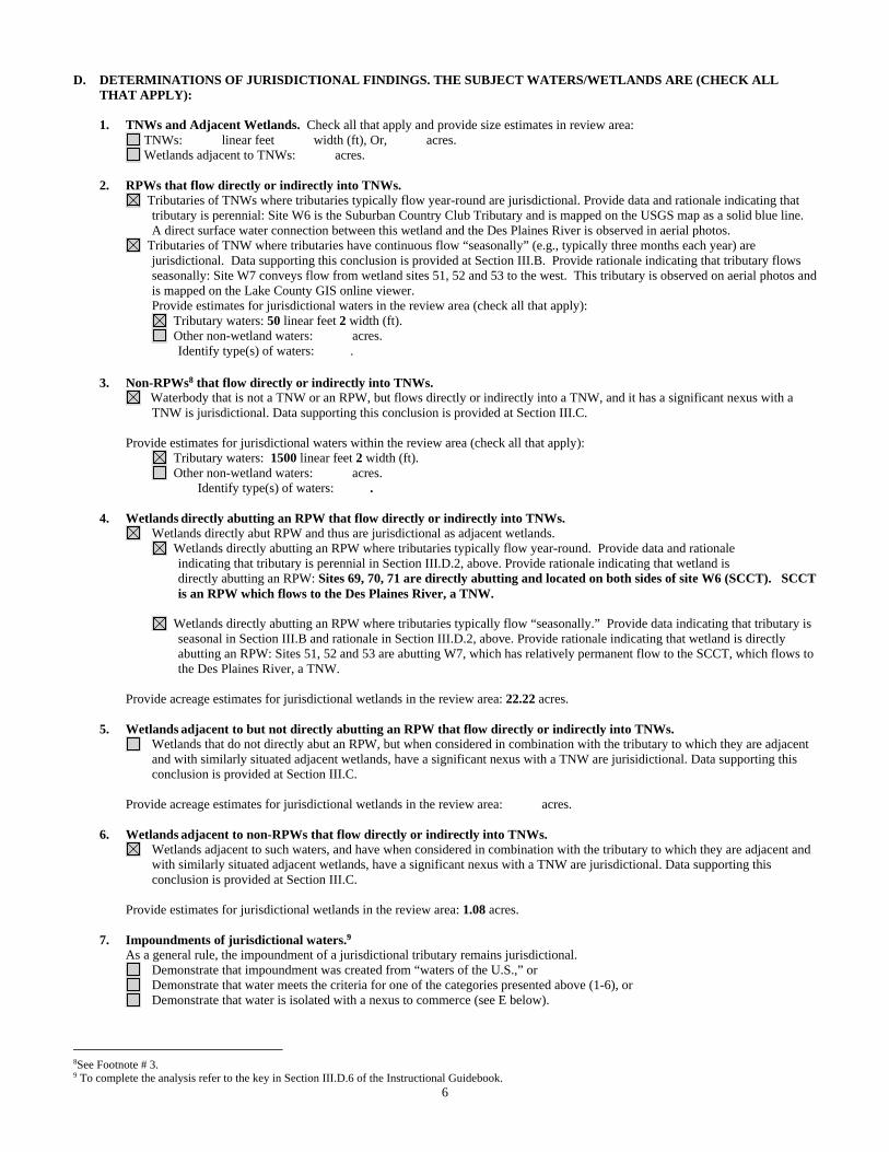
D. DETERMINATIONS OF JURISDICTIONAL FINDINGS. THE SUBJECT WATERS/WETLANDS ARE (CHECK ALL THAT APPLY):
1. TNWs and Adjacent Wetlands. Check all that apply and provide size estimates in review area:
TNWs: linear feet width (ft), Or, acres. Wetlands adjacent to TNWs: acres.
2. RPWs that flow directly or indirectly into TNWs.
Tributaries of TNWs where tributaries typically flow year-round are jurisdictional. Provide data and rationale indicating that tributary is perennial: Site W6 is the Suburban Country Club Tributary and is mapped on the USGS map as a solid blue line. A direct surface water connection between this wetland and the Des Plaines River is observed in aerial photos.
Tributaries of TNW where tributaries have continuous flow “seasonally” (e.g., typically three months each year) are jurisdictional. Data supporting this conclusion is provided at Section III.B. Provide rationale indicating that tributary flows seasonally: Site W7 conveys flow from wetland sites 51, 52 and 53 to the west. This tributary is observed on aerial photos and is mapped on the Lake County GIS online viewer.
Provide estimates for jurisdictional waters in the review area (check all that apply): Tributary waters: 50 linear feet 2 width (ft). Other non-wetland waters: acres.
Identify type(s) of waters: .
3. Non-RPWs8 that flow directly or indirectly into TNWs. Waterbody that is not a TNW or an RPW, but flows directly or indirectly into a TNW, and it has a significant nexus with a
TNW is jurisdictional. Data supporting this conclusion is provided at Section III.C. Provide estimates for jurisdictional waters within the review area (check all that apply): Tributary waters: 1500 linear feet 2 width (ft). Other non-wetland waters: acres.
Identify type(s) of waters: . 4. Wetlands directly abutting an RPW that flow directly or indirectly into TNWs. Wetlands directly abut RPW and thus are jurisdictional as adjacent wetlands. Wetlands directly abutting an RPW where tributaries typically flow year-round. Provide data and rationale indicating that tributary is perennial in Section III.D.2, above. Provide rationale indicating that wetland is directly abutting an RPW: Sites 69, 70, 71 are directly abutting and located on both sides of site W6 (SCCT). SCCT
is an RPW which flows to the Des Plaines River, a TNW. Wetlands directly abutting an RPW where tributaries typically flow “seasonally.” Provide data indicating that tributary is
seasonal in Section III.B and rationale in Section III.D.2, above. Provide rationale indicating that wetland is directly abutting an RPW: Sites 51, 52 and 53 are abutting W7, which has relatively permanent flow to the SCCT, which flows to the Des Plaines River, a TNW.
Provide acreage estimates for jurisdictional wetlands in the review area: 22.22 acres.
5. Wetlands adjacent to but not directly abutting an RPW that flow directly or indirectly into TNWs. Wetlands that do not directly abut an RPW, but when considered in combination with the tributary to which they are adjacent
and with similarly situated adjacent wetlands, have a significant nexus with a TNW are jurisidictional. Data supporting this conclusion is provided at Section III.C.
Provide acreage estimates for jurisdictional wetlands in the review area: acres.
6. Wetlands adjacent to non-RPWs that flow directly or indirectly into TNWs.
Wetlands adjacent to such waters, and have when considered in combination with the tributary to which they are adjacent and with similarly situated adjacent wetlands, have a significant nexus with a TNW are jurisdictional. Data supporting this conclusion is provided at Section III.C.
Provide estimates for jurisdictional wetlands in the review area: 1.08 acres. 7. Impoundments of jurisdictional waters.9 As a general rule, the impoundment of a jurisdictional tributary remains jurisdictional.
Demonstrate that impoundment was created from “waters of the U.S.,” or Demonstrate that water meets the criteria for one of the categories presented above (1-6), or Demonstrate that water is isolated with a nexus to commerce (see E below).
8See Footnote # 3. 9 To complete the analysis refer to the key in Section III.D.6 of the Instructional Guidebook.
7
E. ISOLATED [INTERSTATE OR INTRA-STATE] WATERS, INCLUDING ISOLATED WETLANDS, THE USE, DEGRADATION OR DESTRUCTION OF WHICH COULD AFFECT INTERSTATE COMMERCE, INCLUDING ANY SUCH WATERS (CHECK ALL THAT APPLY):10
which are or could be used by interstate or foreign travelers for recreational or other purposes. from which fish or shellfish are or could be taken and sold in interstate or foreign commerce. which are or could be used for industrial purposes by industries in interstate commerce. Interstate isolated waters. Explain: . Other factors. Explain: . Identify water body and summarize rationale supporting determination: . Provide estimates for jurisdictional waters in the review area (check all that apply): Tributary waters: linear feet width (ft). Other non-wetland waters: acres.
Identify type(s) of waters: . Wetlands: acres.
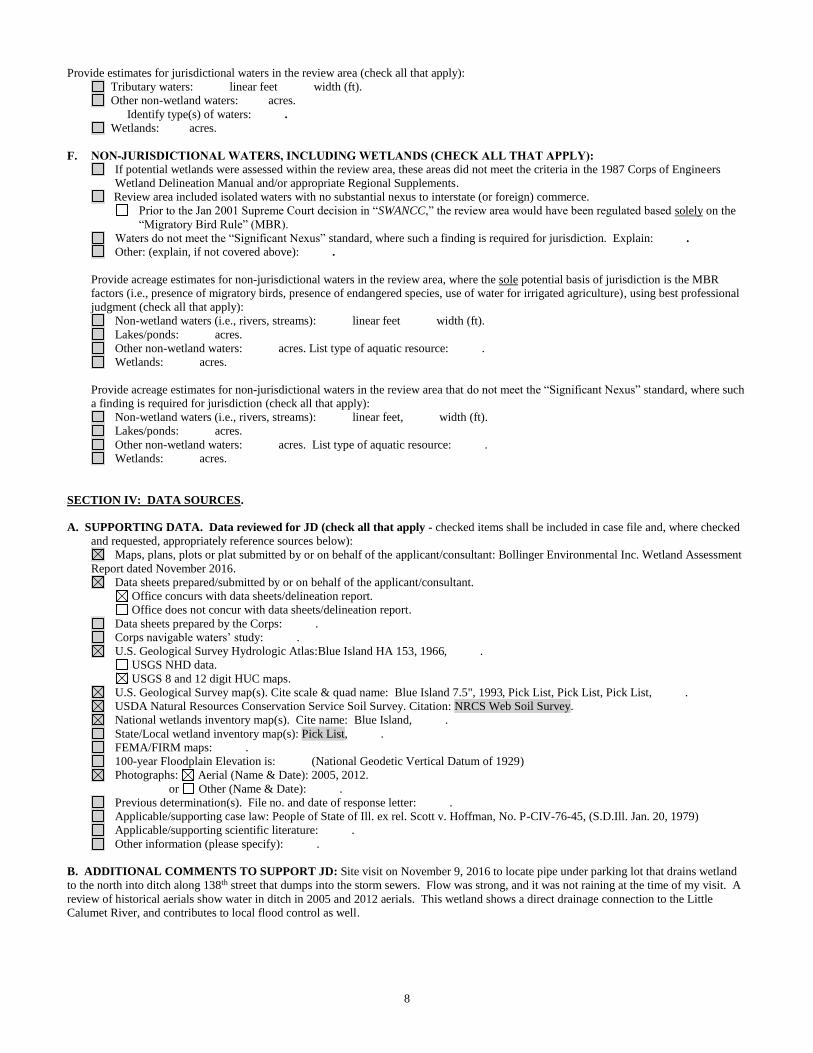
F. NON-JURISDICTIONAL WATERS, INCLUDING WETLANDS (CHECK ALL THAT APPLY): If potential wetlands were assessed within the review area, these areas did not meet the criteria in the 1987 Corps of Engineers
Wetland Delineation Manual and/or appropriate Regional Supplements. Review area included isolated waters with no substantial nexus to interstate (or foreign) commerce.
Prior to the Jan 2001 Supreme Court decision in “SWANCC,” the review area would have been regulated based solely on the “Migratory Bird Rule” (MBR).
Waters do not meet the “Significant Nexus” standard, where such a finding is required for jurisdiction. Explain: . Other: (explain, if not covered above): . Provide acreage estimates for non-jurisdictional waters in the review area, where the sole potential basis of jurisdiction is the MBR
factors (i.e., presence of migratory birds, presence of endangered species, use of water for irrigated agriculture), using best professional judgment (check all that apply):
Non-wetland waters (i.e., rivers, streams): linear feet width (ft). Lakes/ponds: acres. Other non-wetland waters: acres. List type of aquatic resource: . Wetlands: acres.
Provide acreage estimates for non-jurisdictional waters in the review area that do not meet the “Significant Nexus” standard, where such a finding is required for jurisdiction (check all that apply):
Non-wetland waters (i.e., rivers, streams): linear feet, width (ft). Lakes/ponds: acres. Other non-wetland waters: acres. List type of aquatic resource: . Wetlands: acres.
SECTION IV: DATA SOURCES. A. SUPPORTING DATA. Data reviewed for JD (check all that apply - checked items shall be included in case file and, where checked
and requested, appropriately reference sources below): Maps, plans, plots or plat submitted by or on behalf of the applicant/consultant: . Data sheets prepared/submitted by or on behalf of the applicant/consultant.
Office concurs with data sheets/delineation report. Office does not concur with data sheets/delineation report.
Data sheets prepared by the Corps: . Corps navigable waters’ study: . U.S. Geological Survey Hydrologic Atlas: Waukegan HA 234, 1967, .
USGS NHD data. USGS 8 and 12 digit HUC maps.
U.S. Geological Survey map(s). Cite scale & quad name: Waukegan 7.5", 1993, Pick List, Pick List, . USDA Natural Resources Conservation Service Soil Survey. Citation: Soil Survey of Lake County, Illinois (2005). National wetlands inventory map(s). Cite name: Waukegan, . State/Local wetland inventory map(s): Lake County ADID, Pick List, . FEMA/FIRM maps: . 100-year Floodplain Elevation is: (National Geodetic Vertical Datum of 1929) Photographs: Aerial (Name & Date): Google Earth.
or Other (Name & Date): . Previous determination(s). File no. and date of response letter: .
10 Prior to asserting or declining CWA jurisdiction based solely on this category, Corps Districts will elevate the action to Corps and EPA HQ for review consistent with the process described in the Corps/EPA Memorandum Regarding CWA Act Jurisdiction Following Rapanos.

8
Applicable/supporting case law: People of State of Ill. ex rel. Scott v. Hoffman, No. P-CIV-76-45, (S.D.Ill. Jan. 20, 1979) Applicable/supporting scientific literature: . Other information (please specify): .
B. ADDITIONAL COMMENTS TO SUPPORT JD: .
1
APPROVED JURISDICTIONAL DETERMINATION FORM U.S. Army Corps of Engineers
SECTION I: BACKGROUND INFORMATION A. REPORT COMPLETION DATE FOR APPROVED JURISDICTIONAL DETERMINATION (JD): 10 JAN 17 B. DISTRICT OFFICE, FILE NAME, AND NUMBER: Chicago District, LRC-2010-518 C. PROJECT LOCATION AND BACKGROUND INFORMATION:
State: Illinois County/parish/borough: Lake City: Unincorporated Center coordinates of site (lat/long in degree decimal format): Lat. 42.493°N, Long. -87.881° W. Universal Transverse Mercator: Zone 16 Name of nearest waterbody: Tributary 1a to Des Plaines River Name of nearest Traditional Navigable Water (TNW) into which the aquatic resource flows: Des Plaines River Name of watershed or Hydrologic Unit Code (HUC): Des Plaines (07120004)
Check if map/diagram of review area and/or potential jurisdictional areas is/are available upon request. Check if other sites (e.g., offsite mitigation sites, disposal sites, etc…) are associated with this action and are recorded on a
different JD form. D. REVIEW PERFORMED FOR SITE EVALUATION (CHECK ALL THAT APPLY):
Office (Desk) Determination. Date: 10/25/16 Field Determination. Date(s): 9/4/15, 12/10/15
SECTION II: SUMMARY OF FINDINGS A. RHA SECTION 10 DETERMINATION OF JURISDICTION. There Are no “navigable waters of the U.S.” within Rivers and Harbors Act (RHA) jurisdiction (as defined by 33 CFR part 329) in the review area. [Required]
Waters subject to the ebb and flow of the tide. Waters are presently used, or have been used in the past, or may be susceptible for use to transport interstate or foreign commerce.
Explain: Defined in People of State of Ill. ex rel. Scott v. Hoffman, No. P-CIV-76-45, slip op. at 7 (S.D.Ill. Jan. 20, 1979). B. CWA SECTION 404 DETERMINATION OF JURISDICTION. There Are “waters of the U.S.” within Clean Water Act (CWA) jurisdiction (as defined by 33 CFR part 328) in the review area. [Required] 1. Waters of the U.S. a. Indicate presence of waters of U.S. in review area (check all that apply): 1 TNWs, including territorial seas Wetlands adjacent to TNWs Relatively permanent waters2 (RPWs) that flow directly or indirectly into TNWs Wetlands directly abutting RPWs that flow directly or indirectly into TNWs
b. Identify (estimate) size of waters of the U.S. in the review area: Non-wetland waters: linear feet: width (ft) and/or acres. Wetlands: Wetland 58 = 0.36 acres. c. Limits (boundaries) of jurisdiction based on: 1987 Delineation Manual Elevation of established OHWM (if known): . SECTION III: CWA ANALYSIS A. TNWs AND WETLANDS ADJACENT TO TNWs The agencies will assert jurisdiction over TNWs and wetlands adjacent to TNWs. If the aquatic resource is a TNW, complete
Section III.A.1 and Section III.D.1. only; if the aquatic resource is a wetland adjacent to a TNW, complete Sections III.A.1 and 2 and Section III.D.1.; otherwise, see Section III.B below.
1. TNW Identify TNW: Pick List.
Summarize rationale supporting determination: As defined in People of State of Ill. ex rel. Scott v. Hoffman, No. P-CIV-76-45, slip op. at 7 (S.D.Ill. Jan. 20, 1979).
2. Wetland adjacent to TNW Summarize rationale supporting conclusion that wetland is “adjacent”: .
1 Boxes checked below shall be supported by completing the appropriate sections in Section III below. 2 For purposes of this form, an RPW is defined as a tributary that is not a TNW and that typically flows year-round or has continuous flow at least “seasonally” (e.g., typically 3 months).

2
D. DETERMINATIONS OF JURISDICTIONAL FINDINGS. THE SUBJECT WATERS/WETLANDS ARE (CHECK ALL
THAT APPLY):
1. TNWs and Adjacent Wetlands. Check all that apply and provide size estimates in review area: TNWs: linear feet width (ft), Or, acres. Wetlands adjacent to TNWs: acres.
2. RPWs that flow directly or indirectly into TNWs.
Tributaries of TNWs where tributaries typically flow year-round are jurisdictional. Provide data and rationale indicating that tributary is perennial: .
Tributaries of TNW where tributaries have continuous flow “seasonally” (e.g., typically three months each year) are jurisdictional. Data supporting this conclusion is provided at Section III.B. Provide rationale indicating that tributary flows seasonally: .
Provide estimates for jurisdictional waters in the review area (check all that apply): Tributary waters: linear feet width (ft). Other non-wetland waters: acres.
Identify type(s) of waters: .
4. Wetlands directly abutting an RPW that flow directly or indirectly into TNWs. Wetlands directly abut RPW and thus are jurisdictional as adjacent wetlands. Wetlands directly abutting an RPW where tributaries typically flow year-round. Provide data and rationale indicating that tributary is perennial in Section III.D.2, above. Provide rationale indicating that wetland is directly abutting an RPW: Wetland 58 is directly abutting an RPW (identified in the report as W2, but located
north of the State boundary) that was observed to have flowing water during both site visits. This tributary was also observed crossing Illinois Route 131 to the north of Russell Road. The RPW was of sufficient size and flow volume that it would be expected to flow year-round. This tributary is mapped on the USGS map as a tributary further west of the project area. This creek (Trib 1a) flows to the Des Plaines River which becomes a TNW further south.
Wetlands directly abutting an RPW where tributaries typically flow “seasonally.” Provide data indicating that tributary is
seasonal in Section III.B and rationale in Section III.D.2, above. Provide rationale indicating that wetland is directly abutting an RPW: .
Provide acreage estimates for jurisdictional wetlands in the review area: Wetland 58 = 0.36 acres. SECTION IV: DATA SOURCES. A. SUPPORTING DATA. Data reviewed for JD (check all that apply - checked items shall be included in case file and, where checked
and requested, appropriately reference sources below): Maps, plans, plots or plat submitted by or on behalf of the applicant/consultant: . Data sheets prepared/submitted by or on behalf of the applicant/consultant.
Office concurs with data sheets/delineation report. Office does not concur with data sheets/delineation report.
Data sheets prepared by the Corps: . Corps navigable waters’ study: . U.S. Geological Survey Hydrologic Atlas: Waukegan HA 234, 1967, .
USGS NHD data. USGS 8 and 12 digit HUC maps.
U.S. Geological Survey map(s). Cite scale & quad name: Waukegan 7.5", 1993, Pick List, Pick List, . USDA Natural Resources Conservation Service Soil Survey. Citation: Soil Survey of Lake County, Illinois (2005). National wetlands inventory map(s). Cite name: Waukegan, . State/Local wetland inventory map(s): Lake County ADID, Pick List, . FEMA/FIRM maps: . 100-year Floodplain Elevation is: (National Geodetic Vertical Datum of 1929) Photographs: Aerial (Name & Date): Google Earth.
or Other (Name & Date): . Previous determination(s). File no. and date of response letter: . Applicable/supporting case law: People of State of Ill. ex rel. Scott v. Hoffman, No. P-CIV-76-45, (S.D.Ill. Jan. 20, 1979) Applicable/supporting scientific literature: . Other information (please specify): .
B. ADDITIONAL COMMENTS TO SUPPORT JD: .

APPROVED JURISDICTIONAL DETERMINATION FORM
U.S. Army Corps of Engineers
SECTION I: BACKGROUND INFORMATION
A. REPORT COMPLETION DATE FOR APPROVED JURISDICTIONAL DETERMINATION (JD): January 9, 2017
B. DISTRICT OFFICE, FILE NAME, AND NUMBER: Chicago District, Fox River, UPRR, LRC-2015-937
C. PROJECT LOCATION AND BACKGROUND INFORMATION: The Fox River at Site 18 near Kesslinger Road in Geneva, within
the Chicago District, USACE
State: Illinois County: Lake, McHenry, Kane City: Multiple
Center coordinates of site (lat/long in degree decimal format): Lat. 42.0483048 ° N, Long. -88.2915890 ° W.
Name of nearest Traditional Navigable Water (TNW) into which the aquatic resource flows: Fox River and Chain of Lakes
Name of watershed or Hydrologic Unit Code (HUC): Upper Fox (07120006), Lower Fox (07120007)
Check if map/diagram of review area and/or potential jurisdictional areas is/are available upon request.
D. REVIEW PERFORMED FOR SITE EVALUATION: Office (Desk) Determination. Date: 8/17/2015
SECTION II: SUMMARY OF FINDINGS
A. RHA SECTION 10 DETERMINATION OF JURISDICTION.
There Are “navigable waters of the U.S.” within Rivers and Harbors Act (RHA) jurisdiction (as defined by 33 CFR part 329) in the review
area.
Waters are presently used, or have been used in the past, or may be susceptible for use to transport interstate or foreign commerce.
Explain: Defined in People of State of Ill. ex rel. Scott v. Hoffman, No. P-CIV-76-45, slip op. at 7 (S.D.Ill. Jan. 20, 1979).
B. CWA SECTION 404 DETERMINATION OF JURISDICTION.
There Are “waters of the U.S.” within Clean Water Act (CWA) jurisdiction (as defined by 33 CFR part 328) in the review area.
1. Waters of the U.S.
a. Indicate presence of waters of U.S. in review area: TNWs, including territorial seas
b. Identify (estimate) size of waters of the U.S. in the review area:
Non-wetland waters: 387544 linear feet: width (ft) and/or 10800 acres.
c. Limits (boundaries) of jurisdiction based on: Established by OHWM.
Elevation of established OHWM (if known): .
SECTION III: CWA ANALYSIS
A. TNWs AND WETLANDS ADJACENT TO TNWs
The agencies will assert jurisdiction over TNWs and wetlands adjacent to TNWs. If the aquatic resource is a TNW, complete
Section III.A.1 and Section III.D.1. only; if the aquatic resource is a wetland adjacent to a TNW, complete Sections III.A.1 and 2
and Section III.D.1.; otherwise, see Section III.B below.
1. TNW
Identify TNW: Fox River and the Chain of Lakes.
Summarize rationale supporting determination: The Fox River is defined as a navigable waterway in People of State of Ill. ex rel.
Scott v. Hoffman, No. P-CIV-76-45, slip op. at 7 (S.D.Ill. Jan. 20, 1979).
D. DETERMINATIONS OF JURISDICTIONAL FINDINGS. THE SUBJECT WATERS/WETLANDS ARE (CHECK ALL
THAT APPLY): 1. TNWs and Adjacent Wetlands. Check all that apply and provide size estimates in review area:
TNWs: 387544 linear feet width (ft), Or, 10800 acres.
SECTION IV: DATA SOURCES.
A. SUPPORTING DATA. Data reviewed for JD (check all that apply - checked items shall be included in case file and, where checked
and requested, appropriately reference sources below):
Maps, plans, plots or plat submitted by or on behalf of the applicant/consultant: Huff & Huff Inc. Wetland and "Waters of the U.S."
Investigation Report dated July 2016.
Corps navigable waters’ study: .
U.S. Geological Survey Hydrologic Atlas: Geneva.
USGS 8 and 12 digit HUC maps.
U.S. Geological Survey map(s). Cite scale & quad name: Multiple 7.5" quads.
FEMA/FIRM maps: .
100-year Floodplain Elevation is: (National Geodetic Vertical Datum of 1929)
Photographs: Aerial (Name & Date): , or Other (Name & Date): .
Previous determination(s). File no. and date of response letter: multiple.
Applicable/supporting case law: People of State of Ill. ex rel. Scott v. Hoffman, No. P-CIV-76-45, (S.D.Ill. Jan. 20, 1979)
Other information (please specify): .
1
APPROVED JURISDICTIONAL DETERMINATION FORM
U.S. Army Corps of Engineers
SECTION I: BACKGROUND INFORMATION
A. REPORT COMPLETION DATE FOR APPROVED JURISDICTIONAL DETERMINATION (JD): January 9, 2017
B. DISTRICT OFFICE, FILE NAME, AND NUMBER: Chicago District, UPRR, LRC-2015-937
C. PROJECT LOCATION AND BACKGROUND INFORMATION: Kesslinger Road from Kress to Peck Road
State: Illinois County/parish/borough: Kane City: Geneva & West Chicago
Center coordinates of site (lat/long in degree decimal format): Lat. 41.88162°N, Long. -88.30392° W.
Universal Transverse Mercator: Zone 16
Name of nearest waterbody: Fox River
Name of nearest Traditional Navigable Water (TNW) into which the aquatic resource flows: Fox River
Name of watershed or Hydrologic Unit Code (HUC): Upper Fox (07120006)
Check if map/diagram of review area and/or potential jurisdictional areas is/are available upon request.
Check if other sites (e.g., offsite mitigation sites, disposal sites, etc…) are associated with this action and are recorded on a
different JD form.
D. REVIEW PERFORMED FOR SITE EVALUATION (CHECK ALL THAT APPLY):
Office (Desk) Determination. Date: December 13, 2016
Field Determination. Date(s): November 15, 2016
SECTION II: SUMMARY OF FINDINGS
A. RHA SECTION 10 DETERMINATION OF JURISDICTION.
There Are no “navigable waters of the U.S.” within Rivers and Harbors Act (RHA) jurisdiction (as defined by 33 CFR part 329) in the
review area. [Required]
Waters subject to the ebb and flow of the tide.
Waters are presently used, or have been used in the past, or may be susceptible for use to transport interstate or foreign commerce.
Explain: Defined in People of State of Ill. ex rel. Scott v. Hoffman, No. P-CIV-76-45, slip op. at 7 (S.D.Ill. Jan. 20, 1979).
B. CWA SECTION 404 DETERMINATION OF JURISDICTION.
There Are “waters of the U.S.” within Clean Water Act (CWA) jurisdiction (as defined by 33 CFR part 328) in the review area. [Required]
1. Waters of the U.S.
a. Indicate presence of waters of U.S. in review area (check all that apply): 1
TNWs, including territorial seas
Wetlands adjacent to TNWs
Relatively permanent waters2 (RPWs) that flow directly or indirectly into TNWs
Wetlands directly abutting RPWs that flow directly or indirectly into TNWs
b. Identify (estimate) size of waters of the U.S. in the review area:
Non-wetland waters: 45000 linear feet: 3 width (ft) and/or 1.54 acres.
Wetlands: 8.97 acres.
c. Limits (boundaries) of jurisdiction based on: Midwest Supplement
Elevation of established OHWM (if known): .
SECTION III: CWA ANALYSIS
A. TNWs AND WETLANDS ADJACENT TO TNWs
The agencies will assert jurisdiction over TNWs and wetlands adjacent to TNWs. If the aquatic resource is a TNW, complete
Section III.A.1 and Section III.D.1. only; if the aquatic resource is a wetland adjacent to a TNW, complete Sections III.A.1 and 2
and Section III.D.1.; otherwise, see Section III.B below.
1. TNW
Identify TNW: Pick List.
Summarize rationale supporting determination: As defined in People of State of Ill. ex rel. Scott v. Hoffman, No. P-CIV-76-45,
slip op. at 7 (S.D.Ill. Jan. 20, 1979).
2. Wetland adjacent to TNW
Summarize rationale supporting conclusion that wetland is “adjacent”: .
1 Boxes checked below shall be supported by completing the appropriate sections in Section III below. 2 For purposes of this form, an RPW is defined as a tributary that is not a TNW and that typically flows year-round or has continuous flow at least “seasonally”
(e.g., typically 3 months).
2
D. DETERMINATIONS OF JURISDICTIONAL FINDINGS. THE SUBJECT WATERS/WETLANDS ARE (CHECK ALL
THAT APPLY):
1. TNWs and Adjacent Wetlands. Check all that apply and provide size estimates in review area:
TNWs: linear feet width (ft), Or, acres.
Wetlands adjacent to TNWs: acres.
2. RPWs that flow directly or indirectly into TNWs.
Tributaries of TNWs where tributaries typically flow year-round are jurisdictional. Provide data and rationale indicating that
tributary is perennial: Site 1 WOUS, Site 3 WOUS, Site 5 WOUS, Site 6 WOUS, Site 7 WOUS, Site 8 WOUS, Site 16
WOUS, Site 20 WOUS and Site 21 WOUS all had flowing water at the time of my visit, and appear to have year round flow
based on site conditions.
Tributaries of TNW where tributaries have continuous flow “seasonally” (e.g., typically three months each year) are
jurisdictional. Data supporting this conclusion is provided at Section III.B. Provide rationale indicating that tributary flows
seasonally: .
Provide estimates for jurisdictional waters in the review area (check all that apply):
Tributary waters: 45000 linear feet 2-3 width (ft).
Other non-wetland waters: acres.
Identify type(s) of waters: .
4. Wetlands directly abutting an RPW that flow directly or indirectly into TNWs. Wetlands directly abut RPW and thus are jurisdictional as adjacent wetlands.
Wetlands directly abutting an RPW where tributaries typically flow year-round. Provide data and rationale
indicating that tributary is perennial in Section III.D.2, above. Provide rationale indicating that wetland is
directly abutting an RPW: Sites 1, 3, 6 (A, B, C, D, E), Site 7, Site 8 (A, B), Site 9, Site 12, Site 14, Site 16, Site 17,
Site 19 & Site 20 Wetlands are all bisected by the associated WOUS above.
Wetlands directly abutting an RPW where tributaries typically flow “seasonally.” Provide data indicating that tributary is
seasonal in Section III.B and rationale in Section III.D.2, above. Provide rationale indicating that wetland is directly
abutting an RPW: .
Provide acreage estimates for jurisdictional wetlands in the review area: 8.97 acres.
SECTION IV: DATA SOURCES.
A. SUPPORTING DATA. Data reviewed for JD (check all that apply - checked items shall be included in case file and, where checked
and requested, appropriately reference sources below):
Maps, plans, plots or plat submitted by or on behalf of the applicant/consultant: Huff & Huff, Inc. Wetland and "Waters of the
U.S." Investigation Report dated Jyly 2016.
Data sheets prepared/submitted by or on behalf of the applicant/consultant.
Office concurs with data sheets/delineation report.
Office does not concur with data sheets/delineation report.
Data sheets prepared by the Corps: .
Corps navigable waters’ study: .
U.S. Geological Survey Hydrologic Atlas:Geneva HA 142, 1965, .
USGS NHD data.
USGS 8 and 12 digit HUC maps.
U.S. Geological Survey map(s). Cite scale & quad name: Geneva 7.5", 1993, Pick List, Pick List, .
USDA Natural Resources Conservation Service Soil Survey. Citation: Soil Survey of Kane County, Illinois (2003).
National wetlands inventory map(s). Cite name: Geneva, .
State/Local wetland inventory map(s): Kane County ADID, Pick List, .
FEMA/FIRM maps: .
100-year Floodplain Elevation is: (National Geodetic Vertical Datum of 1929)
Photographs: Aerial (Name & Date): .
or Other (Name & Date): .
Previous determination(s). File no. and date of response letter: .
Applicable/supporting case law: People of State of Ill. ex rel. Scott v. Hoffman, No. P-CIV-76-45, (S.D.Ill. Jan. 20, 1979)
Applicable/supporting scientific literature: .
Other information (please specify): .
B. ADDITIONAL COMMENTS TO SUPPORT JD: Site visit on November 15, 2016 to walk all sites and observe flow.
1
APPROVED JURISDICTIONAL DETERMINATION FORM
U.S. Army Corps of Engineers
This form should be completed by following the instructions provided in Section IV of the JD Form Instructional Guidebook.
SECTION I: BACKGROUND INFORMATION
A. REPORT COMPLETION DATE FOR APPROVED JURISDICTIONAL DETERMINATION (JD): January 9, 2017
B. DISTRICT OFFICE, FILE NAME, AND NUMBER: Chicago District, AirGas, LRC-2016-868
C. PROJECT LOCATION AND BACKGROUND INFORMATION: 1200 W 138th St.
State: Illinois County/parish/borough: Cook City: Riverdale
Center coordinates of site (lat/long in degree decimal format): Lat. 41.64405°N, Long. -87.65302° W.
Universal Transverse Mercator: Zone 16
Name of nearest waterbody: Little Calumet River
Name of nearest Traditional Navigable Water (TNW) into which the aquatic resource flows: Calumet River
Name of watershed or Hydrologic Unit Code (HUC): Little Calumet-Galien (04040001)
Check if map/diagram of review area and/or potential jurisdictional areas is/are available upon request.
Check if other sites (e.g., offsite mitigation sites, disposal sites, etc…) are associated with this action and are recorded on a
different JD form.
D. REVIEW PERFORMED FOR SITE EVALUATION (CHECK ALL THAT APPLY):
Office (Desk) Determination. Date: December 21, 2016
Field Determination. Date(s): December 9, 2016
SECTION II: SUMMARY OF FINDINGS
A. RHA SECTION 10 DETERMINATION OF JURISDICTION.
There Are no “navigable waters of the U.S.” within Rivers and Harbors Act (RHA) jurisdiction (as defined by 33 CFR part 329) in the
review area. [Required]
Waters subject to the ebb and flow of the tide.
Waters are presently used, or have been used in the past, or may be susceptible for use to transport interstate or foreign commerce.
Explain: Defined in People of State of Ill. ex rel. Scott v. Hoffman, No. P-CIV-76-45, slip op. at 7 (S.D.Ill. Jan. 20, 1979).
B. CWA SECTION 404 DETERMINATION OF JURISDICTION.
There Are “waters of the U.S.” within Clean Water Act (CWA) jurisdiction (as defined by 33 CFR part 328) in the review area. [Required]
1. Waters of the U.S.
a. Indicate presence of waters of U.S. in review area (check all that apply): 1
TNWs, including territorial seas
Wetlands adjacent to TNWs
Relatively permanent waters2 (RPWs) that flow directly or indirectly into TNWs
Non-RPWs that flow directly or indirectly into TNWs
Wetlands directly abutting RPWs that flow directly or indirectly into TNWs
Wetlands adjacent to but not directly abutting RPWs that flow directly or indirectly into TNWs
Wetlands adjacent to non-RPWs that flow directly or indirectly into TNWs
Impoundments of jurisdictional waters
Isolated (interstate or intrastate) waters, including isolated wetlands
b. Identify (estimate) size of waters of the U.S. in the review area:
Non-wetland waters: linear feet: width (ft) and/or acres.
Wetlands: 0.6 acres.
c. Limits (boundaries) of jurisdiction based on: Midwest Supplement
Elevation of established OHWM (if known): .
2. Non-regulated waters/wetlands (check if applicable):3
Potentially jurisdictional waters and/or wetlands were assessed within the review area and determined to be not jurisdictional.
Explain: .
1 Boxes checked below shall be supported by completing the appropriate sections in Section III below. 2 For purposes of this form, an RPW is defined as a tributary that is not a TNW and that typically flows year-round or has continuous flow at least “seasonally” (e.g., typically 3 months). 3 Supporting documentation is presented in Section III.F.
2
SECTION III: CWA ANALYSIS
A. TNWs AND WETLANDS ADJACENT TO TNWs
The agencies will assert jurisdiction over TNWs and wetlands adjacent to TNWs. If the aquatic resource is a TNW, complete
Section III.A.1 and Section III.D.1. only; if the aquatic resource is a wetland adjacent to a TNW, complete Sections III.A.1 and 2
and Section III.D.1.; otherwise, see Section III.B below.
1. TNW
Identify TNW: Pick List.
Summarize rationale supporting determination: As defined in People of State of Ill. ex rel. Scott v. Hoffman, No. P-CIV-76-45,
slip op. at 7 (S.D.Ill. Jan. 20, 1979).
2. Wetland adjacent to TNW
Summarize rationale supporting conclusion that wetland is “adjacent”: .
B. CHARACTERISTICS OF TRIBUTARY (THAT IS NOT A TNW) AND ITS ADJACENT WETLANDS (IF ANY):
This section summarizes information regarding characteristics of the tributary and its adjacent wetlands, if any, and it helps
determine whether or not the standards for jurisdiction established under Rapanos have been met.
The agencies will assert jurisdiction over non-navigable tributaries of TNWs where the tributaries are “relatively permanent
waters” (RPWs), i.e. tributaries that typically flow year-round or have continuous flow at least seasonally (e.g., typically 3
months). A wetland that directly abuts an RPW is also jurisdictional. If the aquatic resource is not a TNW, but has year-round
(perennial) flow, skip to Section III.D.2. If the aquatic resource is a wetland directly abutting a tributary with perennial flow,
skip to Section III.D.4.
A wetland that is adjacent to but that does not directly abut an RPW requires a significant nexus evaluation. Corps districts and
EPA regions will include in the record any available information that documents the existence of a significant nexus between a
relatively permanent tributary that is not perennial (and its adjacent wetlands if any) and a traditional navigable water, even
though a significant nexus finding is not required as a matter of law.
If the waterbody4 is not an RPW, or a wetland directly abutting an RPW, a JD will require additional data to determine if the
waterbody has a significant nexus with a TNW. If the tributary has adjacent wetlands, the significant nexus evaluation must
consider the tributary in combination with all of its adjacent wetlands. This significant nexus evaluation that combines, for
analytical purposes, the tributary and all of its adjacent wetlands is used whether the review area identified in the JD request is
the tributary, or its adjacent wetlands, or both. If the JD covers a tributary with adjacent wetlands, complete Section III.B.1 for
the tributary, Section III.B.2 for any onsite wetlands, and Section III.B.3 for all wetlands adjacent to that tributary, both onsite
and offsite. The determination whether a significant nexus exists is determined in Section III.C below.
1. Characteristics of non-TNWs that flow directly or indirectly into TNW
(i) General Area Conditions:
Watershed size: 462669 acres
Drainage area: 10292 Pick List
Average annual rainfall: 38.43 inches
Average annual snowfall: 31.5 inches
(ii) Physical Characteristics:
(a) Relationship with TNW:
Tributary flows directly into TNW.
Tributary flows through Pick List tributaries before entering TNW.
Project waters are 1-2 river miles from TNW.
Project waters are 1 (or less) river miles from RPW.
Project waters are 1-2 aerial (straight) miles from TNW.
Project waters are 1 (or less) aerial (straight) miles from RPW.
Project waters cross or serve as state boundaries. Explain: .
Identify flow route to TNW5: Wetland drains into storm sewer pipes that flow east and north into the Little Calumet
River.
4 Note that the Instructional Guidebook contains additional information regarding swales, ditches, washes, and erosional features generally and in the arid West. 5 Flow route can be described by identifying, e.g., tributary a, which flows through the review area, to flow into tributary b, which then flows into TNW.
3
Tributary stream order, if known: 1.
(b) General Tributary Characteristics (check all that apply):
Tributary is: Natural
Artificial (man-made). Explain: Small excavated ditch to Storm Sewers.
Manipulated (man-altered). Explain: .
Tributary properties with respect to top of bank (estimate):
Average width: 1 feet
Average depth: 0.5 feet
Average side slopes: Vertical (1:1 or less).
Primary tributary substrate composition (check all that apply):
Silts Sands Concrete
Cobbles Gravel Muck
Bedrock Vegetation. Type/% cover:
Other. Explain: .
Tributary condition/stability [e.g., highly eroding, sloughing banks]. Explain: Stable small channel.
Presence of run/riffle/pool complexes. Explain: Absent.
Tributary geometry: Relatively straight
Tributary gradient (approximate average slope): 1 %
(c) Flow:
Tributary provides for: Intermittent but not seasonal flow
Estimate average number of flow events in review area/year: 20 (or greater)
Describe flow regime: Small ditch to Storm Sewer flows after rain events for several days, and after snow melt for
several days.
Other information on duration and volume: .
Surface flow is: Discrete and confined. Characteristics: Small man-made channel to concrete storm sewer pipes.
Subsurface flow: No. Explain findings: .
Dye (or other) test performed: .
Tributary has (check all that apply):
Bed and banks
OHWM6 (check all indicators that apply):
clear, natural line impressed on the bank the presence of litter and debris
changes in the character of soil destruction of terrestrial vegetation
shelving the presence of wrack line
vegetation matted down, bent, or absent sediment sorting
leaf litter disturbed or washed away scour
sediment deposition multiple observed or predicted flow events
water staining abrupt change in plant community
other (list):
Discontinuous OHWM.7 Explain: .
If factors other than the OHWM were used to determine lateral extent of CWA jurisdiction (check all that apply):
High Tide Line indicated by: Mean High Water Mark indicated by:
oil or scum line along shore objects survey to available datum;
fine shell or debris deposits (foreshore) physical markings;
physical markings/characteristics vegetation lines/changes in vegetation types.
tidal gauges
other (list):
(iii) Chemical Characteristics:
Characterize tributary (e.g., water color is clear, discolored, oily film; water quality; general watershed characteristics, etc.).
Explain: Water is cloudy.
Identify specific pollutants, if known: Silts and road salt.
6A natural or man-made discontinuity in the OHWM does not necessarily sever jurisdiction (e.g., where the stream temporarily flows underground, or where
the OHWM has been removed by development or agricultural practices). Where there is a break in the OHWM that is unrelated to the waterbody’s flow regime (e.g., flow over a rock outcrop or through a culvert), the agencies will look for indicators of flow above and below the break. 7Ibid.
4
(iv) Biological Characteristics. Channel supports (check all that apply):
Riparian corridor. Characteristics (type, average width): .
Wetland fringe. Characteristics: .
Habitat for:
Federally Listed species. Explain findings: .
Fish/spawn areas. Explain findings: .
Other environmentally-sensitive species. Explain findings: .
Aquatic/wildlife diversity. Explain findings: .
2. Characteristics of wetlands adjacent to non-TNW that flow directly or indirectly into TNW
(i) Physical Characteristics:
(a) General Wetland Characteristics:
Properties:
Wetland size: 0.6 acres
Wetland type. Explain: Emergent.
Wetland quality. Explain: Low.
Project wetlands cross or serve as state boundaries. Explain: .
(b) General Flow Relationship with Non-TNW:
Flow is: Intermittent flow. Explain: Wetland fills up with water and drains out via pipe under concrete parking lot into
man-made channel that leads into storm sewers under 138th Street; and flows out into pipe when it rains and when there is snow melt.
Surface flow is: Overland sheetflow
Characteristics: Deep wetland pocket with outlet at north central location via pipe..
Subsurface flow: Unknown. Explain findings: .
Dye (or other) test performed: .
(c) Wetland Adjacency Determination with Non-TNW:
Directly abutting
Not directly abutting
Discrete wetland hydrologic connection. Explain: .
Ecological connection. Explain: .
Separated by berm/barrier. Explain: .
(d) Proximity (Relationship) to TNW
Project wetlands are 1-2 river miles from TNW.
Project waters are 1-2 aerial (straight) miles from TNW.
Flow is from: Wetland to navigable waters.
Estimate approximate location of wetland as within the 50 - 100-year floodplain.
(ii) Chemical Characteristics:
Characterize wetland system (e.g., water color is clear, brown, oil film on surface; water quality; general watershed
characteristics; etc.). Explain: Water is clear, but impacted by road salts.
Identify specific pollutants, if known: Road salts and silt.
(iii) Biological Characteristics. Wetland supports (check all that apply):
Riparian buffer. Characteristics (type, average width): .
Vegetation type/percent cover. Explain: .
Habitat for:
Federally Listed species. Explain findings: .
Fish/spawn areas. Explain findings: .
Other environmentally-sensitive species. Explain findings: .
Aquatic/wildlife diversity. Explain findings: .
3. Characteristics of all wetlands adjacent to the tributary (if any)
All wetland(s) being considered in the cumulative analysis: 1
Approximately ( 0.6 ) acres in total are being considered in the cumulative analysis.
5
For each wetland, specify the following:
Name/ID Directly abuts? (Y/N) Size (in acres) Name/ID Directly abuts? (Y/N) Size (in acres)
Wetland 1 Y 0,6
Summarize overall biological, chemical and physical functions being performed: This wetland is adjacent and
contiguous to the tributary to the Little Calumet River, which has intermittent flow, and exhibits a surface water connection to a
traditional navigable waterway. This surface water connection demonstrates the ability of the tributary to carry pollutants, flood
waters, nutrients and organic carbon to the TNW from the subject wetland. The adjacent wetland has the ability to reduce the
amount of pollutants and floodwaters reaching the TNW. The headwater wetland is receiving a percentage of its water from
groundwater and from runoff from the surrounding uplands before it flows into Little Calumet River. Wetlands such as these
provide stormwater storage, habitat, sediment/toxicant retention and nutrient removal/transformation. The decrease of
sedimentation, pollutants, flooding, nutrients and habitat provided by the subject wetland provides a positive effect to the
downstream intermittent waters and traditional navigable waters..
C. SIGNIFICANT NEXUS DETERMINATION
A significant nexus analysis will assess the flow characteristics and functions of the tributary itself and the functions performed
by any wetlands adjacent to the tributary to determine if they significantly affect the chemical, physical, and biological integrity
of a TNW. For each of the following situations, a significant nexus exists if the tributary, in combination with all of its adjacent
wetlands, has more than a speculative or insubstantial effect on the chemical, physical and/or biological integrity of a TNW.
Considerations when evaluating significant nexus include, but are not limited to the volume, duration, and frequency of the flow
of water in the tributary and its proximity to a TNW, and the functions performed by the tributary and all its adjacent
wetlands. It is not appropriate to determine significant nexus based solely on any specific threshold of distance (e.g. between a
tributary and its adjacent wetland or between a tributary and the TNW). Similarly, the fact an adjacent wetland lies within or
outside of a floodplain is not solely determinative of significant nexus.
Draw connections between the features documented and the effects on the TNW, as identified in the Rapanos Guidance and
discussed in the Instructional Guidebook. Factors to consider include, for example:
Does the tributary, in combination with its adjacent wetlands (if any), have the capacity to carry pollutants or flood waters to
TNWs, or to reduce the amount of pollutants or flood waters reaching a TNW?
Does the tributary, in combination with its adjacent wetlands (if any), provide habitat and lifecycle support functions for fish and
other species, such as feeding, nesting, spawning, or rearing young for species that are present in the TNW?
Does the tributary, in combination with its adjacent wetlands (if any), have the capacity to transfer nutrients and organic carbon that
support downstream foodwebs?
Does the tributary, in combination with its adjacent wetlands (if any), have other relationships to the physical, chemical, or
biological integrity of the TNW?
Note: the above list of considerations is not inclusive and other functions observed or known to occur should be documented
below:
1. Significant nexus findings for non-RPW that has no adjacent wetlands and flows directly or indirectly into TNWs. Explain
findings of presence or absence of significant nexus below, based on the tributary itself, then go to Section III.D: .
2. Significant nexus findings for non-RPW and its adjacent wetlands, where the non-RPW flows directly or indirectly into
TNWs. Explain findings of presence or absence of significant nexus below, based on the tributary in combination with all of its
adjacent wetlands, then go to Section III.D: The wetland alone, and in combination with other area wetlands, significantly affect the
chemical, physical and biological integrity of the Little Calumet River. Stomwater storage provided by the subject wetland affects
the frequency and extent of downstream flooding, decreasing flood peaks in the Little Calumet River, and in turn impacting
navigation and downstream bank erosion and sedimentation. The sediment and pollutant/toxicant retention provided by the subject
wetland has a direct positive effect on the Little Calumet River in regards to navigation and aquatic food webs that are not adapted
to thrive in sediment-choked environments. These factors contribute to the finding of a significant nexus between the on-site
wetland and the TNW.
3. Significant nexus findings for wetlands adjacent to an RPW but that do not directly abut the RPW. Explain findings of
presence or absence of significant nexus below, based on the tributary in combination with all of its adjacent wetlands, then go to
Section III.D: .
D. DETERMINATIONS OF JURISDICTIONAL FINDINGS. THE SUBJECT WATERS/WETLANDS ARE (CHECK ALL
THAT APPLY):

6
1. TNWs and Adjacent Wetlands. Check all that apply and provide size estimates in review area:
TNWs: linear feet width (ft), Or, acres.
Wetlands adjacent to TNWs: acres.
2. RPWs that flow directly or indirectly into TNWs.
Tributaries of TNWs where tributaries typically flow year-round are jurisdictional. Provide data and rationale indicating that
tributary is perennial: .
Tributaries of TNW where tributaries have continuous flow “seasonally” (e.g., typically three months each year) are
jurisdictional. Data supporting this conclusion is provided at Section III.B. Provide rationale indicating that tributary flows
seasonally: .
Provide estimates for jurisdictional waters in the review area (check all that apply):
Tributary waters: linear feet width (ft).
Other non-wetland waters: acres.
Identify type(s) of waters: .
3. Non-RPWs8 that flow directly or indirectly into TNWs.
Waterbody that is not a TNW or an RPW, but flows directly or indirectly into a TNW, and it has a significant nexus with a
TNW is jurisdictional. Data supporting this conclusion is provided at Section III.C.
Provide estimates for jurisdictional waters within the review area (check all that apply):
Tributary waters: linear feet width (ft).
Other non-wetland waters: acres.
Identify type(s) of waters: .
4. Wetlands directly abutting an RPW that flow directly or indirectly into TNWs. Wetlands directly abut RPW and thus are jurisdictional as adjacent wetlands.
Wetlands directly abutting an RPW where tributaries typically flow year-round. Provide data and rationale
indicating that tributary is perennial in Section III.D.2, above. Provide rationale indicating that wetland is
directly abutting an RPW: .
Wetlands directly abutting an RPW where tributaries typically flow “seasonally.” Provide data indicating that tributary is
seasonal in Section III.B and rationale in Section III.D.2, above. Provide rationale indicating that wetland is directly
abutting an RPW: .
Provide acreage estimates for jurisdictional wetlands in the review area: acres.
5. Wetlands adjacent to but not directly abutting an RPW that flow directly or indirectly into TNWs.
Wetlands that do not directly abut an RPW, but when considered in combination with the tributary to which they are adjacent
and with similarly situated adjacent wetlands, have a significant nexus with a TNW are jurisidictional. Data supporting this
conclusion is provided at Section III.C.
Provide acreage estimates for jurisdictional wetlands in the review area: acres.
6. Wetlands adjacent to non-RPWs that flow directly or indirectly into TNWs. Wetlands adjacent to such waters, and have when considered in combination with the tributary to which they are adjacent and
with similarly situated adjacent wetlands, have a significant nexus with a TNW are jurisdictional. Data supporting this
conclusion is provided at Section III.C.
Provide estimates for jurisdictional wetlands in the review area: 0.6 acres.
7. Impoundments of jurisdictional waters.9
As a general rule, the impoundment of a jurisdictional tributary remains jurisdictional.
Demonstrate that impoundment was created from “waters of the U.S.,” or
Demonstrate that water meets the criteria for one of the categories presented above (1-6), or
Demonstrate that water is isolated with a nexus to commerce (see E below).
8See Footnote # 3. 9 To complete the analysis refer to the key in Section III.D.6 of the Instructional Guidebook.

7
E. ISOLATED [INTERSTATE OR INTRA-STATE] WATERS, INCLUDING ISOLATED WETLANDS, THE USE,
DEGRADATION OR DESTRUCTION OF WHICH COULD AFFECT INTERSTATE COMMERCE, INCLUDING ANY
SUCH WATERS (CHECK ALL THAT APPLY):10
which are or could be used by interstate or foreign travelers for recreational or other purposes.
from which fish or shellfish are or could be taken and sold in interstate or foreign commerce.
which are or could be used for industrial purposes by industries in interstate commerce.
Interstate isolated waters. Explain: .
Other factors. Explain: .
Identify water body and summarize rationale supporting determination: .
10 Prior to asserting or declining CWA jurisdiction based solely on this category, Corps Districts will elevate the action to Corps and EPA HQ for
review consistent with the process described in the Corps/EPA Memorandum Regarding CWA Act Jurisdiction Following Rapanos.
8
Provide estimates for jurisdictional waters in the review area (check all that apply):
Tributary waters: linear feet width (ft).
Other non-wetland waters: acres.
Identify type(s) of waters: .
Wetlands: acres.
F. NON-JURISDICTIONAL WATERS, INCLUDING WETLANDS (CHECK ALL THAT APPLY):
If potential wetlands were assessed within the review area, these areas did not meet the criteria in the 1987 Corps of Engineers
Wetland Delineation Manual and/or appropriate Regional Supplements.
Review area included isolated waters with no substantial nexus to interstate (or foreign) commerce.
Prior to the Jan 2001 Supreme Court decision in “SWANCC,” the review area would have been regulated based solely on the
“Migratory Bird Rule” (MBR).
Waters do not meet the “Significant Nexus” standard, where such a finding is required for jurisdiction. Explain: .
Other: (explain, if not covered above): .
Provide acreage estimates for non-jurisdictional waters in the review area, where the sole potential basis of jurisdiction is the MBR
factors (i.e., presence of migratory birds, presence of endangered species, use of water for irrigated agriculture), using best professional
judgment (check all that apply):
Non-wetland waters (i.e., rivers, streams): linear feet width (ft).
Lakes/ponds: acres.
Other non-wetland waters: acres. List type of aquatic resource: .
Wetlands: acres.
Provide acreage estimates for non-jurisdictional waters in the review area that do not meet the “Significant Nexus” standard, where such
a finding is required for jurisdiction (check all that apply):
Non-wetland waters (i.e., rivers, streams): linear feet, width (ft).
Lakes/ponds: acres.
Other non-wetland waters: acres. List type of aquatic resource: .
Wetlands: acres.
SECTION IV: DATA SOURCES.
A. SUPPORTING DATA. Data reviewed for JD (check all that apply - checked items shall be included in case file and, where checked
and requested, appropriately reference sources below):
Maps, plans, plots or plat submitted by or on behalf of the applicant/consultant: Bollinger Environmental Inc. Wetland Assessment
Report dated November 2016.
Data sheets prepared/submitted by or on behalf of the applicant/consultant.
Office concurs with data sheets/delineation report.
Office does not concur with data sheets/delineation report.
Data sheets prepared by the Corps: .
Corps navigable waters’ study: .
U.S. Geological Survey Hydrologic Atlas:Blue Island HA 153, 1966, .
USGS NHD data.
USGS 8 and 12 digit HUC maps.
U.S. Geological Survey map(s). Cite scale & quad name: Blue Island 7.5", 1993, Pick List, Pick List, Pick List, .
USDA Natural Resources Conservation Service Soil Survey. Citation: NRCS Web Soil Survey.
National wetlands inventory map(s). Cite name: Blue Island, .
State/Local wetland inventory map(s): Pick List, .
FEMA/FIRM maps: .
100-year Floodplain Elevation is: (National Geodetic Vertical Datum of 1929)
Photographs: Aerial (Name & Date): 2005, 2012.
or Other (Name & Date): .
Previous determination(s). File no. and date of response letter: .
Applicable/supporting case law: People of State of Ill. ex rel. Scott v. Hoffman, No. P-CIV-76-45, (S.D.Ill. Jan. 20, 1979)
Applicable/supporting scientific literature: .
Other information (please specify): .
B. ADDITIONAL COMMENTS TO SUPPORT JD: Site visit on November 9, 2016 to locate pipe under parking lot that drains wetland
to the north into ditch along 138th street that dumps into the storm sewers. Flow was strong, and it was not raining at the time of my visit. A
review of historical aerials show water in ditch in 2005 and 2012 aerials. This wetland shows a direct drainage connection to the Little
Calumet River, and contributes to local flood control as well.
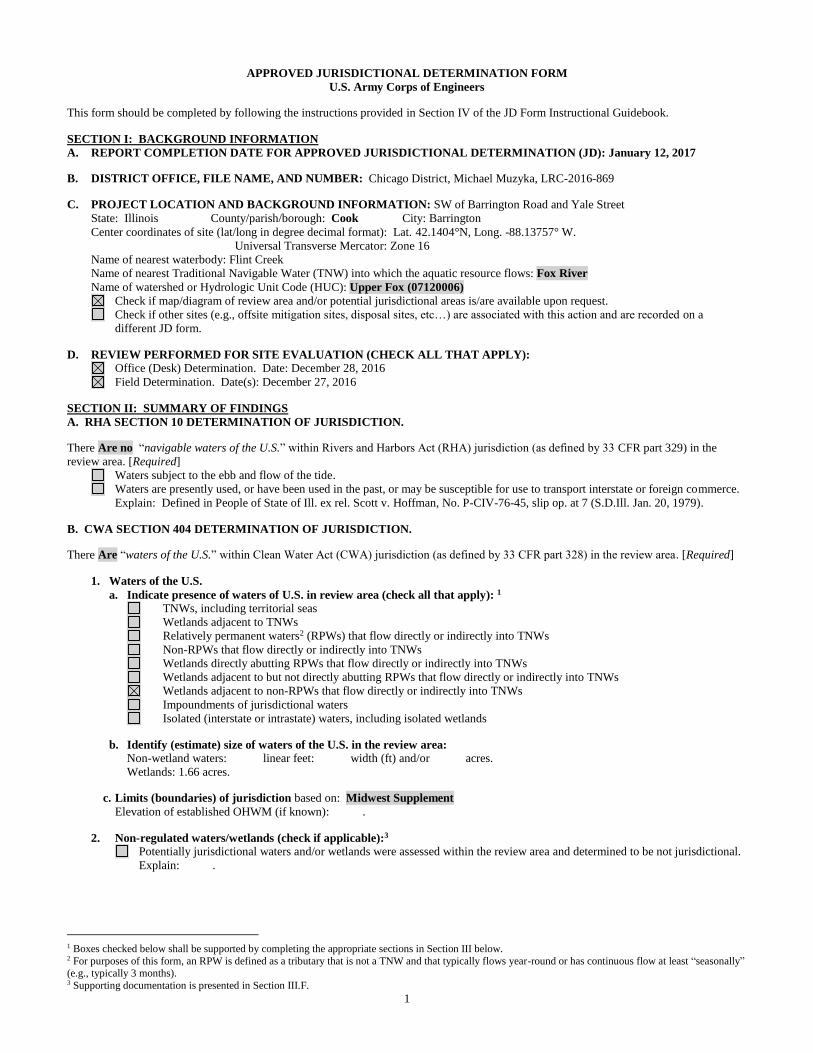
1
APPROVED JURISDICTIONAL DETERMINATION FORM
U.S. Army Corps of Engineers
This form should be completed by following the instructions provided in Section IV of the JD Form Instructional Guidebook.
SECTION I: BACKGROUND INFORMATION
A. REPORT COMPLETION DATE FOR APPROVED JURISDICTIONAL DETERMINATION (JD): January 12, 2017
B. DISTRICT OFFICE, FILE NAME, AND NUMBER: Chicago District, Michael Muzyka, LRC-2016-869
C. PROJECT LOCATION AND BACKGROUND INFORMATION: SW of Barrington Road and Yale Street
State: Illinois County/parish/borough: Cook City: Barrington
Center coordinates of site (lat/long in degree decimal format): Lat. 42.1404°N, Long. -88.13757° W.
Universal Transverse Mercator: Zone 16
Name of nearest waterbody: Flint Creek
Name of nearest Traditional Navigable Water (TNW) into which the aquatic resource flows: Fox River
Name of watershed or Hydrologic Unit Code (HUC): Upper Fox (07120006)
Check if map/diagram of review area and/or potential jurisdictional areas is/are available upon request.
Check if other sites (e.g., offsite mitigation sites, disposal sites, etc…) are associated with this action and are recorded on a
different JD form.
D. REVIEW PERFORMED FOR SITE EVALUATION (CHECK ALL THAT APPLY):
Office (Desk) Determination. Date: December 28, 2016
Field Determination. Date(s): December 27, 2016
SECTION II: SUMMARY OF FINDINGS
A. RHA SECTION 10 DETERMINATION OF JURISDICTION.
There Are no “navigable waters of the U.S.” within Rivers and Harbors Act (RHA) jurisdiction (as defined by 33 CFR part 329) in the
review area. [Required]
Waters subject to the ebb and flow of the tide.
Waters are presently used, or have been used in the past, or may be susceptible for use to transport interstate or foreign commerce.
Explain: Defined in People of State of Ill. ex rel. Scott v. Hoffman, No. P-CIV-76-45, slip op. at 7 (S.D.Ill. Jan. 20, 1979).
B. CWA SECTION 404 DETERMINATION OF JURISDICTION.
There Are “waters of the U.S.” within Clean Water Act (CWA) jurisdiction (as defined by 33 CFR part 328) in the review area. [Required]
1. Waters of the U.S.
a. Indicate presence of waters of U.S. in review area (check all that apply): 1
TNWs, including territorial seas
Wetlands adjacent to TNWs
Relatively permanent waters2 (RPWs) that flow directly or indirectly into TNWs
Non-RPWs that flow directly or indirectly into TNWs
Wetlands directly abutting RPWs that flow directly or indirectly into TNWs
Wetlands adjacent to but not directly abutting RPWs that flow directly or indirectly into TNWs
Wetlands adjacent to non-RPWs that flow directly or indirectly into TNWs
Impoundments of jurisdictional waters
Isolated (interstate or intrastate) waters, including isolated wetlands
b. Identify (estimate) size of waters of the U.S. in the review area:
Non-wetland waters: linear feet: width (ft) and/or acres.
Wetlands: 1.66 acres.
c. Limits (boundaries) of jurisdiction based on: Midwest Supplement
Elevation of established OHWM (if known): .
2. Non-regulated waters/wetlands (check if applicable):3
Potentially jurisdictional waters and/or wetlands were assessed within the review area and determined to be not jurisdictional.
Explain: .
1 Boxes checked below shall be supported by completing the appropriate sections in Section III below. 2 For purposes of this form, an RPW is defined as a tributary that is not a TNW and that typically flows year-round or has continuous flow at least “seasonally” (e.g., typically 3 months). 3 Supporting documentation is presented in Section III.F.
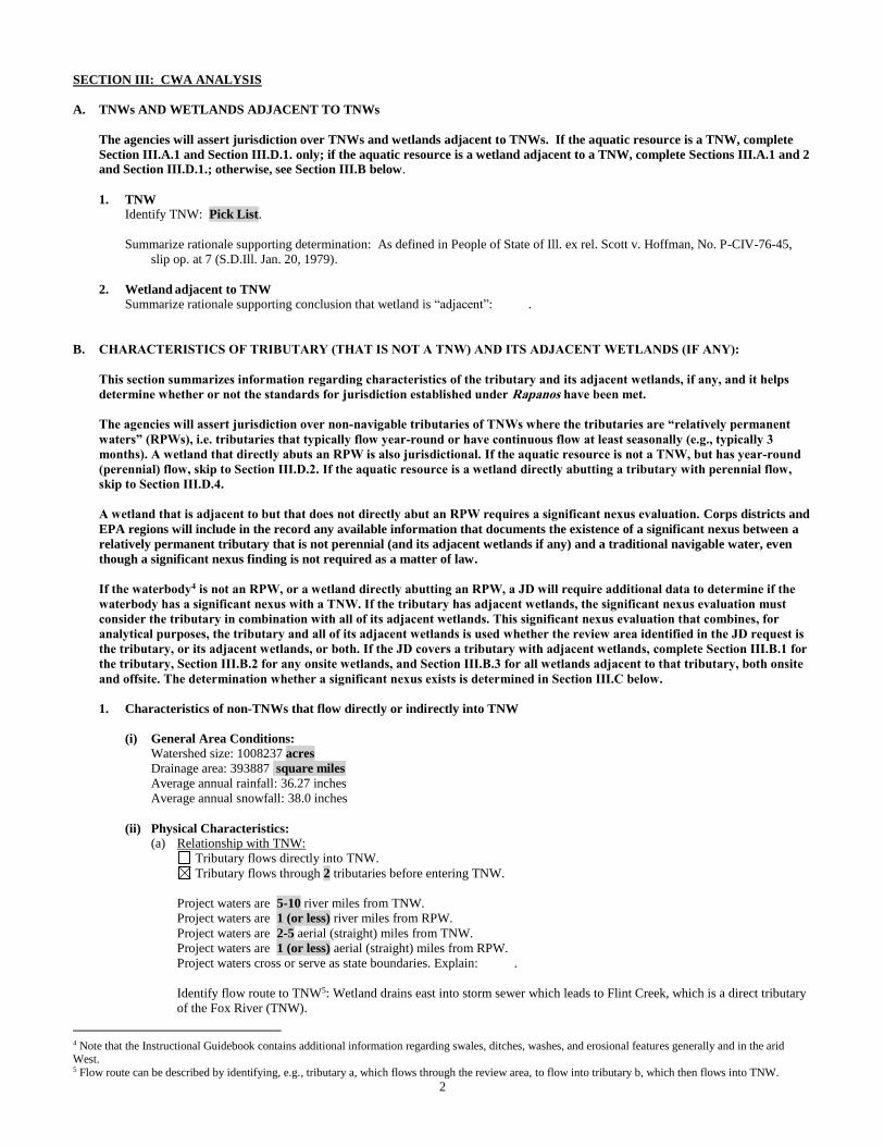
2
SECTION III: CWA ANALYSIS
A. TNWs AND WETLANDS ADJACENT TO TNWs
The agencies will assert jurisdiction over TNWs and wetlands adjacent to TNWs. If the aquatic resource is a TNW, complete
Section III.A.1 and Section III.D.1. only; if the aquatic resource is a wetland adjacent to a TNW, complete Sections III.A.1 and 2
and Section III.D.1.; otherwise, see Section III.B below.
1. TNW
Identify TNW: Pick List.
Summarize rationale supporting determination: As defined in People of State of Ill. ex rel. Scott v. Hoffman, No. P-CIV-76-45,
slip op. at 7 (S.D.Ill. Jan. 20, 1979).
2. Wetland adjacent to TNW
Summarize rationale supporting conclusion that wetland is “adjacent”: .
B. CHARACTERISTICS OF TRIBUTARY (THAT IS NOT A TNW) AND ITS ADJACENT WETLANDS (IF ANY):
This section summarizes information regarding characteristics of the tributary and its adjacent wetlands, if any, and it helps
determine whether or not the standards for jurisdiction established under Rapanos have been met.
The agencies will assert jurisdiction over non-navigable tributaries of TNWs where the tributaries are “relatively permanent
waters” (RPWs), i.e. tributaries that typically flow year-round or have continuous flow at least seasonally (e.g., typically 3
months). A wetland that directly abuts an RPW is also jurisdictional. If the aquatic resource is not a TNW, but has year-round
(perennial) flow, skip to Section III.D.2. If the aquatic resource is a wetland directly abutting a tributary with perennial flow,
skip to Section III.D.4.
A wetland that is adjacent to but that does not directly abut an RPW requires a significant nexus evaluation. Corps districts and
EPA regions will include in the record any available information that documents the existence of a significant nexus between a
relatively permanent tributary that is not perennial (and its adjacent wetlands if any) and a traditional navigable water, even
though a significant nexus finding is not required as a matter of law.
If the waterbody4 is not an RPW, or a wetland directly abutting an RPW, a JD will require additional data to determine if the
waterbody has a significant nexus with a TNW. If the tributary has adjacent wetlands, the significant nexus evaluation must
consider the tributary in combination with all of its adjacent wetlands. This significant nexus evaluation that combines, for
analytical purposes, the tributary and all of its adjacent wetlands is used whether the review area identified in the JD request is
the tributary, or its adjacent wetlands, or both. If the JD covers a tributary with adjacent wetlands, complete Section III.B.1 for
the tributary, Section III.B.2 for any onsite wetlands, and Section III.B.3 for all wetlands adjacent to that tributary, both onsite
and offsite. The determination whether a significant nexus exists is determined in Section III.C below.
1. Characteristics of non-TNWs that flow directly or indirectly into TNW
(i) General Area Conditions:
Watershed size: 1008237 acres
Drainage area: 393887 square miles
Average annual rainfall: 36.27 inches
Average annual snowfall: 38.0 inches
(ii) Physical Characteristics:
(a) Relationship with TNW:
Tributary flows directly into TNW.
Tributary flows through 2 tributaries before entering TNW.
Project waters are 5-10 river miles from TNW.
Project waters are 1 (or less) river miles from RPW.
Project waters are 2-5 aerial (straight) miles from TNW.
Project waters are 1 (or less) aerial (straight) miles from RPW.
Project waters cross or serve as state boundaries. Explain: .
Identify flow route to TNW5: Wetland drains east into storm sewer which leads to Flint Creek, which is a direct tributary
of the Fox River (TNW).
4 Note that the Instructional Guidebook contains additional information regarding swales, ditches, washes, and erosional features generally and in the arid West. 5 Flow route can be described by identifying, e.g., tributary a, which flows through the review area, to flow into tributary b, which then flows into TNW.
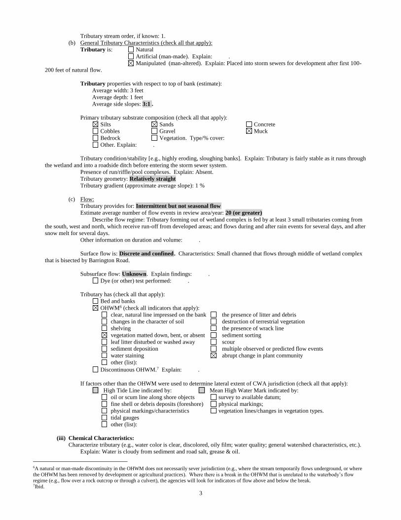
3
Tributary stream order, if known: 1.
(b) General Tributary Characteristics (check all that apply):
Tributary is: Natural
Artificial (man-made). Explain: .
Manipulated (man-altered). Explain: Placed into storm sewers for development after first 100-
200 feet of natural flow.
Tributary properties with respect to top of bank (estimate):
Average width: 3 feet
Average depth: 1 feet
Average side slopes: 3:1 .
Primary tributary substrate composition (check all that apply):
Silts Sands Concrete
Cobbles Gravel Muck
Bedrock Vegetation. Type/% cover:
Other. Explain: .
Tributary condition/stability [e.g., highly eroding, sloughing banks]. Explain: Tributary is fairly stable as it runs through
the wetland and into a roadside ditch before entering the storm sewer system.
Presence of run/riffle/pool complexes. Explain: Absent.
Tributary geometry: Relatively straight
Tributary gradient (approximate average slope): 1 %
(c) Flow:
Tributary provides for: Intermittent but not seasonal flow
Estimate average number of flow events in review area/year: 20 (or greater)
Describe flow regime: Tributary forming out of wetland complex is fed by at least 3 small tributaries coming from
the south, west and north, which receive run-off from developed areas; and flows during and after rain events for several days, and after
snow melt for several days.
Other information on duration and volume: .
Surface flow is: Discrete and confined. Characteristics: Small channed that flows through middle of wetland complex
that is bisected by Barrington Road.
Subsurface flow: Unknown. Explain findings: .
Dye (or other) test performed: .
Tributary has (check all that apply):
Bed and banks
OHWM6 (check all indicators that apply):
clear, natural line impressed on the bank the presence of litter and debris
changes in the character of soil destruction of terrestrial vegetation
shelving the presence of wrack line
vegetation matted down, bent, or absent sediment sorting
leaf litter disturbed or washed away scour
sediment deposition multiple observed or predicted flow events
water staining abrupt change in plant community
other (list):
Discontinuous OHWM.7 Explain: .
If factors other than the OHWM were used to determine lateral extent of CWA jurisdiction (check all that apply):
High Tide Line indicated by: Mean High Water Mark indicated by:
oil or scum line along shore objects survey to available datum;
fine shell or debris deposits (foreshore) physical markings;
physical markings/characteristics vegetation lines/changes in vegetation types.
tidal gauges
other (list):
(iii) Chemical Characteristics:
Characterize tributary (e.g., water color is clear, discolored, oily film; water quality; general watershed characteristics, etc.).
Explain: Water is cloudy from sediment and road salt, grease & oil.
6A natural or man-made discontinuity in the OHWM does not necessarily sever jurisdiction (e.g., where the stream temporarily flows underground, or where
the OHWM has been removed by development or agricultural practices). Where there is a break in the OHWM that is unrelated to the waterbody’s flow regime (e.g., flow over a rock outcrop or through a culvert), the agencies will look for indicators of flow above and below the break. 7Ibid.

4
Identify specific pollutants, if known: .
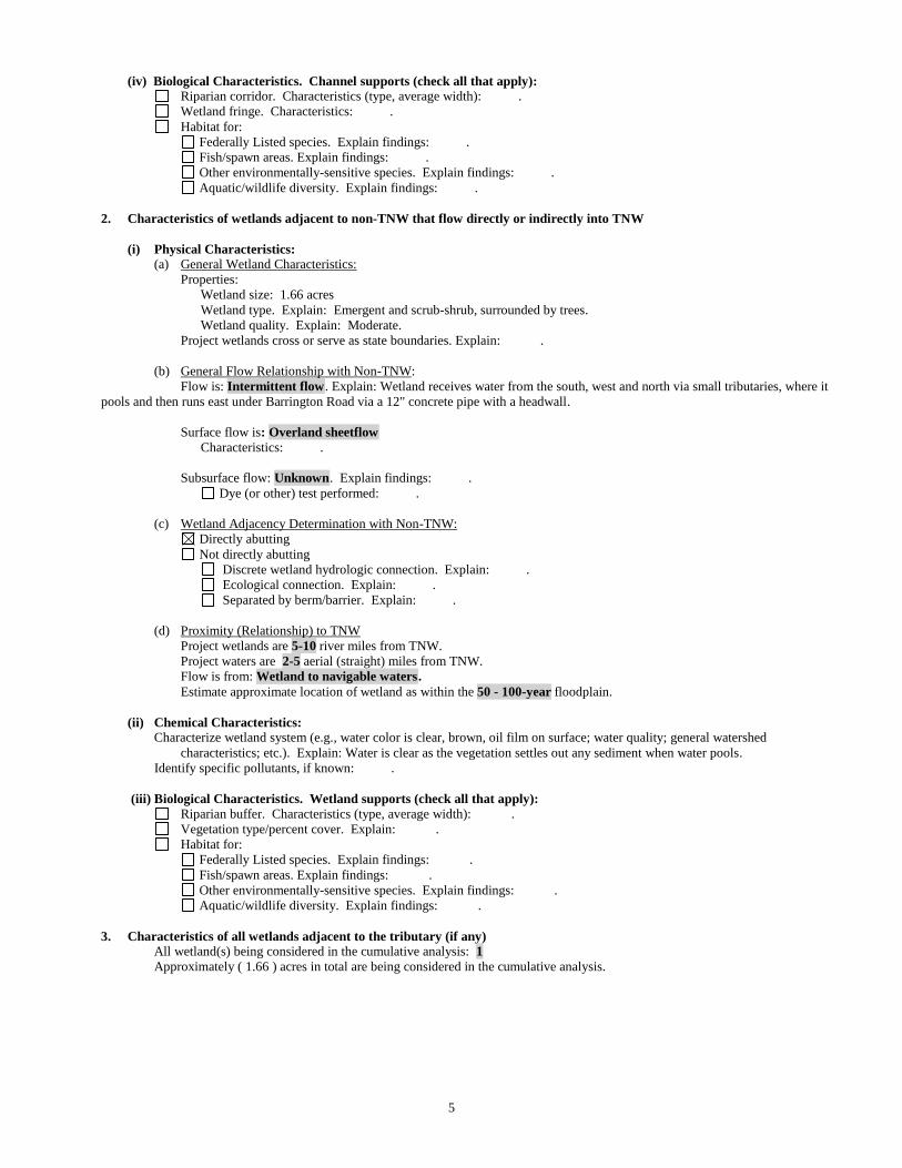
5
(iv) Biological Characteristics. Channel supports (check all that apply):
Riparian corridor. Characteristics (type, average width): .
Wetland fringe. Characteristics: .
Habitat for:
Federally Listed species. Explain findings: .
Fish/spawn areas. Explain findings: .
Other environmentally-sensitive species. Explain findings: .
Aquatic/wildlife diversity. Explain findings: .
2. Characteristics of wetlands adjacent to non-TNW that flow directly or indirectly into TNW
(i) Physical Characteristics:
(a) General Wetland Characteristics:
Properties:
Wetland size: 1.66 acres
Wetland type. Explain: Emergent and scrub-shrub, surrounded by trees.
Wetland quality. Explain: Moderate.
Project wetlands cross or serve as state boundaries. Explain: .
(b) General Flow Relationship with Non-TNW:
Flow is: Intermittent flow. Explain: Wetland receives water from the south, west and north via small tributaries, where it
pools and then runs east under Barrington Road via a 12" concrete pipe with a headwall.
Surface flow is: Overland sheetflow
Characteristics: .
Subsurface flow: Unknown. Explain findings: .
Dye (or other) test performed: .
(c) Wetland Adjacency Determination with Non-TNW:
Directly abutting
Not directly abutting
Discrete wetland hydrologic connection. Explain: .
Ecological connection. Explain: .
Separated by berm/barrier. Explain: .
(d) Proximity (Relationship) to TNW
Project wetlands are 5-10 river miles from TNW.
Project waters are 2-5 aerial (straight) miles from TNW.
Flow is from: Wetland to navigable waters.
Estimate approximate location of wetland as within the 50 - 100-year floodplain.
(ii) Chemical Characteristics:
Characterize wetland system (e.g., water color is clear, brown, oil film on surface; water quality; general watershed
characteristics; etc.). Explain: Water is clear as the vegetation settles out any sediment when water pools.
Identify specific pollutants, if known: .
(iii) Biological Characteristics. Wetland supports (check all that apply):
Riparian buffer. Characteristics (type, average width): .
Vegetation type/percent cover. Explain: .
Habitat for:
Federally Listed species. Explain findings: .
Fish/spawn areas. Explain findings: .
Other environmentally-sensitive species. Explain findings: .
Aquatic/wildlife diversity. Explain findings: .
3. Characteristics of all wetlands adjacent to the tributary (if any)
All wetland(s) being considered in the cumulative analysis: 1
Approximately ( 1.66 ) acres in total are being considered in the cumulative analysis.
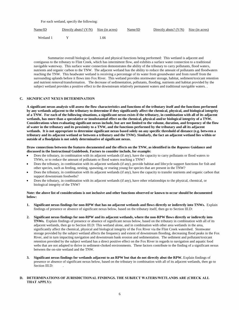
6
For each wetland, specify the following:
Name/ID Directly abuts? (Y/N) Size (in acres) Name/ID Directly abuts? (Y/N) Size (in acres)
Wetland 1 Y 1.66
Summarize overall biological, chemical and physical functions being performed: This wetland is adjacent and
contiguous to the tributary to Flint Creek, which has intermittent flow, and exhibits a surface water connection to a traditional
navigable waterway. This surface water connection demonstrates the ability of the tributary to carry pollutants, flood waters,
nutrients and organic carbon to the TNW. The adjacent wetland has the ability to reduce the amount of pollutants and floodwaters
reaching the TNW. This headwater wetland is receiving a percentage of its water from groundwater and from runoff from the
surrounding uplands before it flows into Fox River. This wetland provides stormwater storage, habitat, sediment/toxicant retention
and nutrient removal/transformation. The decrease of sedimentation, pollutants, flooding, nutrients and habitat provided by the
subject wetland provides a positive effect to the downstream relatively permanent waters and traditional navigable waters. .
C. SIGNIFICANT NEXUS DETERMINATION
A significant nexus analysis will assess the flow characteristics and functions of the tributary itself and the functions performed
by any wetlands adjacent to the tributary to determine if they significantly affect the chemical, physical, and biological integrity
of a TNW. For each of the following situations, a significant nexus exists if the tributary, in combination with all of its adjacent
wetlands, has more than a speculative or insubstantial effect on the chemical, physical and/or biological integrity of a TNW.
Considerations when evaluating significant nexus include, but are not limited to the volume, duration, and frequency of the flow
of water in the tributary and its proximity to a TNW, and the functions performed by the tributary and all its adjacent
wetlands. It is not appropriate to determine significant nexus based solely on any specific threshold of distance (e.g. between a
tributary and its adjacent wetland or between a tributary and the TNW). Similarly, the fact an adjacent wetland lies within or
outside of a floodplain is not solely determinative of significant nexus.
Draw connections between the features documented and the effects on the TNW, as identified in the Rapanos Guidance and
discussed in the Instructional Guidebook. Factors to consider include, for example:
Does the tributary, in combination with its adjacent wetlands (if any), have the capacity to carry pollutants or flood waters to
TNWs, or to reduce the amount of pollutants or flood waters reaching a TNW?
Does the tributary, in combination with its adjacent wetlands (if any), provide habitat and lifecycle support functions for fish and
other species, such as feeding, nesting, spawning, or rearing young for species that are present in the TNW?
Does the tributary, in combination with its adjacent wetlands (if any), have the capacity to transfer nutrients and organic carbon that
support downstream foodwebs?
Does the tributary, in combination with its adjacent wetlands (if any), have other relationships to the physical, chemical, or
biological integrity of the TNW?
Note: the above list of considerations is not inclusive and other functions observed or known to occur should be documented
below:
1. Significant nexus findings for non-RPW that has no adjacent wetlands and flows directly or indirectly into TNWs. Explain
findings of presence or absence of significant nexus below, based on the tributary itself, then go to Section III.D: .
2. Significant nexus findings for non-RPW and its adjacent wetlands, where the non-RPW flows directly or indirectly into
TNWs. Explain findings of presence or absence of significant nexus below, based on the tributary in combination with all of its
adjacent wetlands, then go to Section III.D: This wetland alone, and in combination with other area wetlands in the area,
significantly affect the chemical, physical and biological integrity of the Fox River via the Flint Creek watershed. Stomwater
storage provided by the subject wetland affects the frequency and extent of downstream flooding, decreasing flood peaks in the Fox
River, and in turn impacting navigation and downstream bank erosion and sedimentation. The sediment and pollutant/toxicant
retention provided by the subject wetland has a direct positive effect on the Fox River in regards to navigation and aquatic food
webs that are not adapted to thrive in sediment-choked environments. These factors contribute to the finding of a significant nexus
between the on-site wetland and the TNW.
3. Significant nexus findings for wetlands adjacent to an RPW but that do not directly abut the RPW. Explain findings of
presence or absence of significant nexus below, based on the tributary in combination with all of its adjacent wetlands, then go to
Section III.D: .
D. DETERMINATIONS OF JURISDICTIONAL FINDINGS. THE SUBJECT WATERS/WETLANDS ARE (CHECK ALL
THAT APPLY):
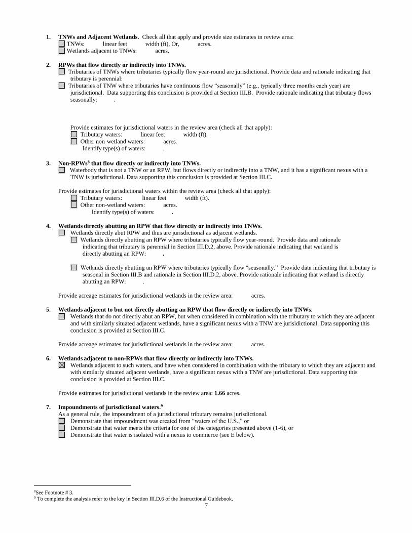
7
1. TNWs and Adjacent Wetlands. Check all that apply and provide size estimates in review area:
TNWs: linear feet width (ft), Or, acres.
Wetlands adjacent to TNWs: acres.
2. RPWs that flow directly or indirectly into TNWs.
Tributaries of TNWs where tributaries typically flow year-round are jurisdictional. Provide data and rationale indicating that
tributary is perennial: .
Tributaries of TNW where tributaries have continuous flow “seasonally” (e.g., typically three months each year) are
jurisdictional. Data supporting this conclusion is provided at Section III.B. Provide rationale indicating that tributary flows
seasonally: .
Provide estimates for jurisdictional waters in the review area (check all that apply):
Tributary waters: linear feet width (ft).
Other non-wetland waters: acres.
Identify type(s) of waters: .
3. Non-RPWs8 that flow directly or indirectly into TNWs.
Waterbody that is not a TNW or an RPW, but flows directly or indirectly into a TNW, and it has a significant nexus with a
TNW is jurisdictional. Data supporting this conclusion is provided at Section III.C.
Provide estimates for jurisdictional waters within the review area (check all that apply):
Tributary waters: linear feet width (ft).
Other non-wetland waters: acres.
Identify type(s) of waters: .
4. Wetlands directly abutting an RPW that flow directly or indirectly into TNWs. Wetlands directly abut RPW and thus are jurisdictional as adjacent wetlands.
Wetlands directly abutting an RPW where tributaries typically flow year-round. Provide data and rationale
indicating that tributary is perennial in Section III.D.2, above. Provide rationale indicating that wetland is
directly abutting an RPW: .
Wetlands directly abutting an RPW where tributaries typically flow “seasonally.” Provide data indicating that tributary is
seasonal in Section III.B and rationale in Section III.D.2, above. Provide rationale indicating that wetland is directly
abutting an RPW: .
Provide acreage estimates for jurisdictional wetlands in the review area: acres.
5. Wetlands adjacent to but not directly abutting an RPW that flow directly or indirectly into TNWs.
Wetlands that do not directly abut an RPW, but when considered in combination with the tributary to which they are adjacent
and with similarly situated adjacent wetlands, have a significant nexus with a TNW are jurisidictional. Data supporting this
conclusion is provided at Section III.C.
Provide acreage estimates for jurisdictional wetlands in the review area: acres.
6. Wetlands adjacent to non-RPWs that flow directly or indirectly into TNWs. Wetlands adjacent to such waters, and have when considered in combination with the tributary to which they are adjacent and
with similarly situated adjacent wetlands, have a significant nexus with a TNW are jurisdictional. Data supporting this
conclusion is provided at Section III.C.
Provide estimates for jurisdictional wetlands in the review area: 1.66 acres.
7. Impoundments of jurisdictional waters.9
As a general rule, the impoundment of a jurisdictional tributary remains jurisdictional.
Demonstrate that impoundment was created from “waters of the U.S.,” or
Demonstrate that water meets the criteria for one of the categories presented above (1-6), or
Demonstrate that water is isolated with a nexus to commerce (see E below).
8See Footnote # 3. 9 To complete the analysis refer to the key in Section III.D.6 of the Instructional Guidebook.
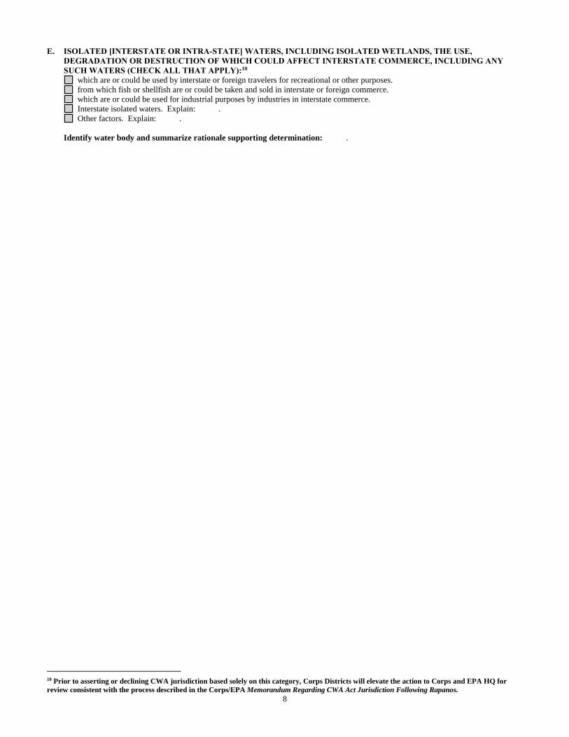
8
E. ISOLATED [INTERSTATE OR INTRA-STATE] WATERS, INCLUDING ISOLATED WETLANDS, THE USE,
DEGRADATION OR DESTRUCTION OF WHICH COULD AFFECT INTERSTATE COMMERCE, INCLUDING ANY
SUCH WATERS (CHECK ALL THAT APPLY):10
which are or could be used by interstate or foreign travelers for recreational or other purposes.
from which fish or shellfish are or could be taken and sold in interstate or foreign commerce.
which are or could be used for industrial purposes by industries in interstate commerce.
Interstate isolated waters. Explain: .
Other factors. Explain: .
Identify water body and summarize rationale supporting determination: .
10 Prior to asserting or declining CWA jurisdiction based solely on this category, Corps Districts will elevate the action to Corps and EPA HQ for
review consistent with the process described in the Corps/EPA Memorandum Regarding CWA Act Jurisdiction Following Rapanos.
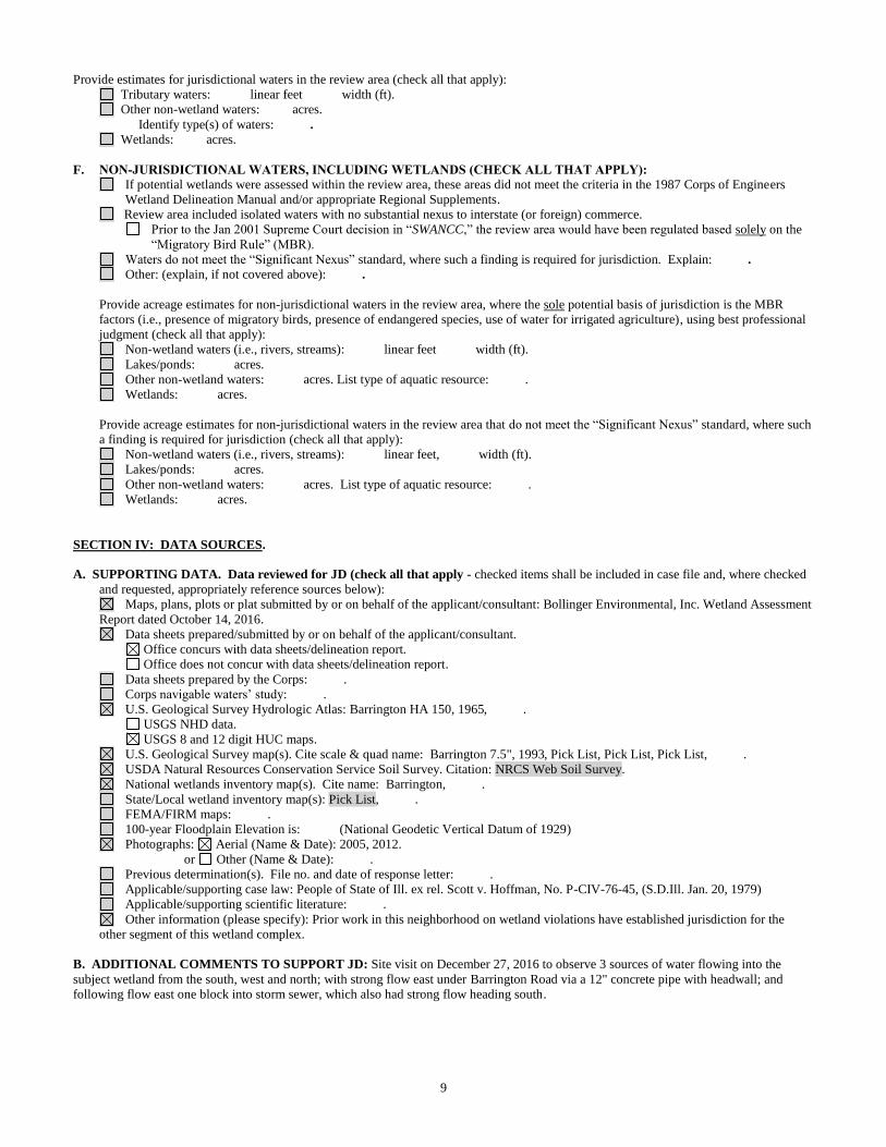
9
Provide estimates for jurisdictional waters in the review area (check all that apply):
Tributary waters: linear feet width (ft).
Other non-wetland waters: acres.
Identify type(s) of waters: .
Wetlands: acres.
F. NON-JURISDICTIONAL WATERS, INCLUDING WETLANDS (CHECK ALL THAT APPLY):
If potential wetlands were assessed within the review area, these areas did not meet the criteria in the 1987 Corps of Engineers
Wetland Delineation Manual and/or appropriate Regional Supplements.
Review area included isolated waters with no substantial nexus to interstate (or foreign) commerce.
Prior to the Jan 2001 Supreme Court decision in “SWANCC,” the review area would have been regulated based solely on the
“Migratory Bird Rule” (MBR).
Waters do not meet the “Significant Nexus” standard, where such a finding is required for jurisdiction. Explain: .
Other: (explain, if not covered above): .
Provide acreage estimates for non-jurisdictional waters in the review area, where the sole potential basis of jurisdiction is the MBR
factors (i.e., presence of migratory birds, presence of endangered species, use of water for irrigated agriculture), using best professional
judgment (check all that apply):
Non-wetland waters (i.e., rivers, streams): linear feet width (ft).
Lakes/ponds: acres.
Other non-wetland waters: acres. List type of aquatic resource: .
Wetlands: acres.
Provide acreage estimates for non-jurisdictional waters in the review area that do not meet the “Significant Nexus” standard, where such
a finding is required for jurisdiction (check all that apply):
Non-wetland waters (i.e., rivers, streams): linear feet, width (ft).
Lakes/ponds: acres.
Other non-wetland waters: acres. List type of aquatic resource: .
Wetlands: acres.
SECTION IV: DATA SOURCES.
A. SUPPORTING DATA. Data reviewed for JD (check all that apply - checked items shall be included in case file and, where checked
and requested, appropriately reference sources below):
Maps, plans, plots or plat submitted by or on behalf of the applicant/consultant: Bollinger Environmental, Inc. Wetland Assessment
Report dated October 14, 2016.
Data sheets prepared/submitted by or on behalf of the applicant/consultant.
Office concurs with data sheets/delineation report.
Office does not concur with data sheets/delineation report.
Data sheets prepared by the Corps: .
Corps navigable waters’ study: .
U.S. Geological Survey Hydrologic Atlas: Barrington HA 150, 1965, .
USGS NHD data.
USGS 8 and 12 digit HUC maps.
U.S. Geological Survey map(s). Cite scale & quad name: Barrington 7.5", 1993, Pick List, Pick List, Pick List, .
USDA Natural Resources Conservation Service Soil Survey. Citation: NRCS Web Soil Survey.
National wetlands inventory map(s). Cite name: Barrington, .
State/Local wetland inventory map(s): Pick List, .
FEMA/FIRM maps: .
100-year Floodplain Elevation is: (National Geodetic Vertical Datum of 1929)
Photographs: Aerial (Name & Date): 2005, 2012.
or Other (Name & Date): .
Previous determination(s). File no. and date of response letter: .
Applicable/supporting case law: People of State of Ill. ex rel. Scott v. Hoffman, No. P-CIV-76-45, (S.D.Ill. Jan. 20, 1979)
Applicable/supporting scientific literature: .
Other information (please specify): Prior work in this neighborhood on wetland violations have established jurisdiction for the
other segment of this wetland complex.
B. ADDITIONAL COMMENTS TO SUPPORT JD: Site visit on December 27, 2016 to observe 3 sources of water flowing into the
subject wetland from the south, west and north; with strong flow east under Barrington Road via a 12" concrete pipe with headwall; and
following flow east one block into storm sewer, which also had strong flow heading south.
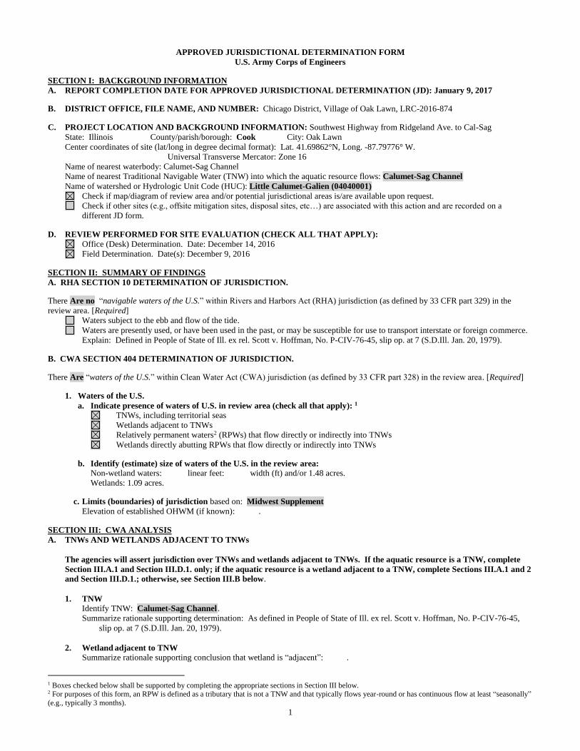
1
APPROVED JURISDICTIONAL DETERMINATION FORM
U.S. Army Corps of Engineers
SECTION I: BACKGROUND INFORMATION
A. REPORT COMPLETION DATE FOR APPROVED JURISDICTIONAL DETERMINATION (JD): January 9, 2017
B. DISTRICT OFFICE, FILE NAME, AND NUMBER: Chicago District, Village of Oak Lawn, LRC-2016-874
C. PROJECT LOCATION AND BACKGROUND INFORMATION: Southwest Highway from Ridgeland Ave. to Cal-Sag
State: Illinois County/parish/borough: Cook City: Oak Lawn
Center coordinates of site (lat/long in degree decimal format): Lat. 41.69862°N, Long. -87.79776° W.
Universal Transverse Mercator: Zone 16
Name of nearest waterbody: Calumet-Sag Channel
Name of nearest Traditional Navigable Water (TNW) into which the aquatic resource flows: Calumet-Sag Channel
Name of watershed or Hydrologic Unit Code (HUC): Little Calumet-Galien (04040001)
Check if map/diagram of review area and/or potential jurisdictional areas is/are available upon request.
Check if other sites (e.g., offsite mitigation sites, disposal sites, etc…) are associated with this action and are recorded on a
different JD form.
D. REVIEW PERFORMED FOR SITE EVALUATION (CHECK ALL THAT APPLY):
Office (Desk) Determination. Date: December 14, 2016
Field Determination. Date(s): December 9, 2016
SECTION II: SUMMARY OF FINDINGS
A. RHA SECTION 10 DETERMINATION OF JURISDICTION.
There Are no “navigable waters of the U.S.” within Rivers and Harbors Act (RHA) jurisdiction (as defined by 33 CFR part 329) in the
review area. [Required]
Waters subject to the ebb and flow of the tide.
Waters are presently used, or have been used in the past, or may be susceptible for use to transport interstate or foreign commerce.
Explain: Defined in People of State of Ill. ex rel. Scott v. Hoffman, No. P-CIV-76-45, slip op. at 7 (S.D.Ill. Jan. 20, 1979).
B. CWA SECTION 404 DETERMINATION OF JURISDICTION.
There Are “waters of the U.S.” within Clean Water Act (CWA) jurisdiction (as defined by 33 CFR part 328) in the review area. [Required]
1. Waters of the U.S.
a. Indicate presence of waters of U.S. in review area (check all that apply): 1
TNWs, including territorial seas
Wetlands adjacent to TNWs
Relatively permanent waters2 (RPWs) that flow directly or indirectly into TNWs
Wetlands directly abutting RPWs that flow directly or indirectly into TNWs
b. Identify (estimate) size of waters of the U.S. in the review area:
Non-wetland waters: linear feet: width (ft) and/or 1.48 acres.
Wetlands: 1.09 acres.
c. Limits (boundaries) of jurisdiction based on: Midwest Supplement
Elevation of established OHWM (if known): .
SECTION III: CWA ANALYSIS
A. TNWs AND WETLANDS ADJACENT TO TNWs
The agencies will assert jurisdiction over TNWs and wetlands adjacent to TNWs. If the aquatic resource is a TNW, complete
Section III.A.1 and Section III.D.1. only; if the aquatic resource is a wetland adjacent to a TNW, complete Sections III.A.1 and 2
and Section III.D.1.; otherwise, see Section III.B below.
1. TNW
Identify TNW: Calumet-Sag Channel .
Summarize rationale supporting determination: As defined in People of State of Ill. ex rel. Scott v. Hoffman, No. P-CIV-76-45,
slip op. at 7 (S.D.Ill. Jan. 20, 1979).
2. Wetland adjacent to TNW
Summarize rationale supporting conclusion that wetland is “adjacent”: .
1 Boxes checked below shall be supported by completing the appropriate sections in Section III below. 2 For purposes of this form, an RPW is defined as a tributary that is not a TNW and that typically flows year-round or has continuous flow at least “seasonally”
(e.g., typically 3 months).

2
D. DETERMINATIONS OF JURISDICTIONAL FINDINGS. THE SUBJECT WATERS/WETLANDS ARE (CHECK ALL
THAT APPLY):
1. TNWs and Adjacent Wetlands. Check all that apply and provide size estimates in review area:
TNWs: 300 linear feet 50 width (ft), Or, 4.44 acres.
Wetlands adjacent to TNWs: 0.66 acres.
2. RPWs that flow directly or indirectly into TNWs.
Tributaries of TNWs where tributaries typically flow year-round are jurisdictional. Provide data and rationale indicating that
tributary is perennial: Stoney Creek and the Tributary to Stoney Creek are wide and deep waters that flow year round; with
Stoney Creek mapped as a blue-line stream on the USGS Maps. The Tributary to the Cal-Sag Channel flows year-round, and
shows up with water on all available aerials.
Tributaries of TNW where tributaries have continuous flow “seasonally” (e.g., typically three months each year) are
jurisdictional. Data supporting this conclusion is provided at Section III.B. Provide rationale indicating that tributary flows
seasonally: .
Provide estimates for jurisdictional waters in the review area (check all that apply):
Tributary waters: 500 linear feet 5-15 width (ft).
Other non-wetland waters: acres.
Identify type(s) of waters: .
4. Wetlands directly abutting an RPW that flow directly or indirectly into TNWs. Wetlands directly abut RPW and thus are jurisdictional as adjacent wetlands.
Wetlands directly abutting an RPW where tributaries typically flow year-round. Provide data and rationale
indicating that tributary is perennial in Section III.D.2, above. Provide rationale indicating that wetland is
directly abutting an RPW: Site 1A, 1B & 1C Wetlands directly abuts both banks of Stoney Creek without
separation.
Wetlands directly abutting an RPW where tributaries typically flow “seasonally.” Provide data indicating that tributary is
seasonal in Section III.B and rationale in Section III.D.2, above. Provide rationale indicating that wetland is directly
abutting an RPW: .
Provide acreage estimates for jurisdictional wetlands in the review area: 1.01 acres.
SECTION IV: DATA SOURCES.
A. SUPPORTING DATA. Data reviewed for JD (check all that apply - checked items shall be included in case file and, where checked
and requested, appropriately reference sources below):
Maps, plans, plots or plat submitted by or on behalf of the applicant/consultant: Huff & Huff, Inc. Wetland and Waters of the U.S.
Investigation Report dated September 2015, Revised September 2016.
Data sheets prepared/submitted by or on behalf of the applicant/consultant.
Office concurs with data sheets/delineation report.
Office does not concur with data sheets/delineation report.
Data sheets prepared by the Corps: .
Corps navigable waters’ study: .
U.S. Geological Survey Hydrologic Atlas:Palos Park HA 145, 1966, .
USGS NHD data.
USGS 8 and 12 digit HUC maps.
U.S. Geological Survey map(s). Cite scale & quad name: Palos Park 7.5", 1993, Pick List, Pick List, Pick List, .
USDA Natural Resources Conservation Service Soil Survey. Citation: NRCS Web Soil Survey.
National wetlands inventory map(s). Cite name: Palos Park, .
State/Local wetland inventory map(s): Pick List, .
FEMA/FIRM maps: .
100-year Floodplain Elevation is: (National Geodetic Vertical Datum of 1929)
Photographs: Aerial (Name & Date): 2005, 2012.
or Other (Name & Date): .
Previous determination(s). File no. and date of response letter: .
Applicable/supporting case law: People of State of Ill. ex rel. Scott v. Hoffman, No. P-CIV-76-45, (S.D.Ill. Jan. 20, 1979)
Applicable/supporting scientific literature: .
Other information (please specify): .
B. ADDITIONAL COMMENTS TO SUPPORT JD: The Calumet-Sag Channel is a documented TNW; and Site 7 & 8 wetlands are
immediately adjacent to the Channel. Sites 1A, 1B & 1C are portions of Stoney Creek (RPW) with aubtting wetlands 1A, 1B & 1C. Site 2 is
a direct tributary of Stoney Creek, and exhibits RPW flow. Site 4 is a direct tributary of the Calumet-Sag Channel, and exhibits RPW flow.
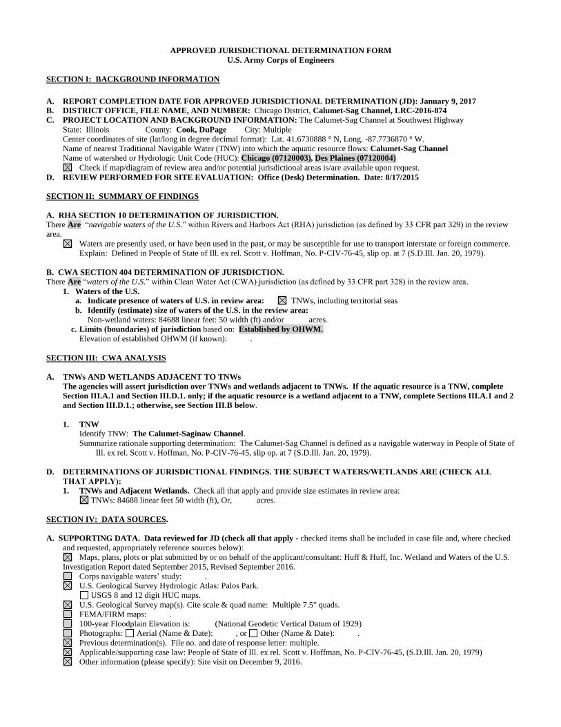
APPROVED JURISDICTIONAL DETERMINATION FORM
U.S. Army Corps of Engineers
SECTION I: BACKGROUND INFORMATION
A. REPORT COMPLETION DATE FOR APPROVED JURISDICTIONAL DETERMINATION (JD): January 9, 2017
B. DISTRICT OFFICE, FILE NAME, AND NUMBER: Chicago District, Calumet-Sag Channel, LRC-2016-874
C. PROJECT LOCATION AND BACKGROUND INFORMATION: The Calumet-Sag Channel at Southwest Highway
State: Illinois County: Cook, DuPage City: Multiple
Center coordinates of site (lat/long in degree decimal format): Lat. 41.6730888 ° N, Long. -87.7736870 ° W.
Name of nearest Traditional Navigable Water (TNW) into which the aquatic resource flows: Calumet-Sag Channel
Name of watershed or Hydrologic Unit Code (HUC): Chicago (07120003), Des Plaines (07120004)
Check if map/diagram of review area and/or potential jurisdictional areas is/are available upon request.
D. REVIEW PERFORMED FOR SITE EVALUATION: Office (Desk) Determination. Date: 8/17/2015
SECTION II: SUMMARY OF FINDINGS
A. RHA SECTION 10 DETERMINATION OF JURISDICTION.
There Are “navigable waters of the U.S.” within Rivers and Harbors Act (RHA) jurisdiction (as defined by 33 CFR part 329) in the review
area.
Waters are presently used, or have been used in the past, or may be susceptible for use to transport interstate or foreign commerce.
Explain: Defined in People of State of Ill. ex rel. Scott v. Hoffman, No. P-CIV-76-45, slip op. at 7 (S.D.Ill. Jan. 20, 1979).
B. CWA SECTION 404 DETERMINATION OF JURISDICTION.
There Are “waters of the U.S.” within Clean Water Act (CWA) jurisdiction (as defined by 33 CFR part 328) in the review area.
1. Waters of the U.S.
a. Indicate presence of waters of U.S. in review area: TNWs, including territorial seas
b. Identify (estimate) size of waters of the U.S. in the review area:
Non-wetland waters: 84688 linear feet: 50 width (ft) and/or acres.
c. Limits (boundaries) of jurisdiction based on: Established by OHWM.
Elevation of established OHWM (if known): .
SECTION III: CWA ANALYSIS
A. TNWs AND WETLANDS ADJACENT TO TNWs
The agencies will assert jurisdiction over TNWs and wetlands adjacent to TNWs. If the aquatic resource is a TNW, complete
Section III.A.1 and Section III.D.1. only; if the aquatic resource is a wetland adjacent to a TNW, complete Sections III.A.1 and 2
and Section III.D.1.; otherwise, see Section III.B below.
1. TNW
Identify TNW: The Calumet-Saginaw Channel.
Summarize rationale supporting determination: The Calumet-Sag Channel is defined as a navigable waterway in People of State of
Ill. ex rel. Scott v. Hoffman, No. P-CIV-76-45, slip op. at 7 (S.D.Ill. Jan. 20, 1979).
D. DETERMINATIONS OF JURISDICTIONAL FINDINGS. THE SUBJECT WATERS/WETLANDS ARE (CHECK ALL
THAT APPLY): 1. TNWs and Adjacent Wetlands. Check all that apply and provide size estimates in review area:
TNWs: 84688 linear feet 50 width (ft), Or, acres.
SECTION IV: DATA SOURCES.
A. SUPPORTING DATA. Data reviewed for JD (check all that apply - checked items shall be included in case file and, where checked
and requested, appropriately reference sources below):
Maps, plans, plots or plat submitted by or on behalf of the applicant/consultant: Huff & Huff, Inc. Wetland and Waters of the U.S.
Investigation Report dated September 2015, Revised September 2016.
Corps navigable waters’ study: .
U.S. Geological Survey Hydrologic Atlas: Palos Park.
USGS 8 and 12 digit HUC maps.
U.S. Geological Survey map(s). Cite scale & quad name: Multiple 7.5" quads.
FEMA/FIRM maps: .
100-year Floodplain Elevation is: (National Geodetic Vertical Datum of 1929)
Photographs: Aerial (Name & Date): , or Other (Name & Date): .
Previous determination(s). File no. and date of response letter: multiple.
Applicable/supporting case law: People of State of Ill. ex rel. Scott v. Hoffman, No. P-CIV-76-45, (S.D.Ill. Jan. 20, 1979)
Other information (please specify): Site visit on December 9, 2016.

1
APPROVED JURISDICTIONAL DETERMINATION FORM U.S. Army Corps of Engineers
SECTION I: BACKGROUND INFORMATION A. REPORT COMPLETION DATE FOR APPROVED JURISDICTIONAL DETERMINATION (JD): January 9, 2017 B. DISTRICT OFFICE, FILE NAME, AND NUMBER: Chicago District, Village of Homer Glen, LRC-2016-891 C. PROJECT LOCATION AND BACKGROUND INFORMATION: 151st Street from Cedar to Bell Roads
State: Illinois County/parish/borough: Will City: Homer Glen Center coordinates of site (lat/long in degree decimal format): Lat. 41.614°N, Long. -87.956° W. Universal Transverse Mercator: Zone 16 Name of nearest waterbody: Fiddyment Creek Name of nearest Traditional Navigable Water (TNW) into which the aquatic resource flows: Illinois and Michigan Canal Name of watershed or Hydrologic Unit Code (HUC): Des Plaines (07120004)
Check if map/diagram of review area and/or potential jurisdictional areas is/are available upon request. Check if other sites (e.g., offsite mitigation sites, disposal sites, etc…) are associated with this action and are recorded on a
different JD form. D. REVIEW PERFORMED FOR SITE EVALUATION (CHECK ALL THAT APPLY):
Office (Desk) Determination. Date: December 14, 2016 Field Determination. Date(s): December 6, 2016
SECTION II: SUMMARY OF FINDINGS A. RHA SECTION 10 DETERMINATION OF JURISDICTION. There Are no “navigable waters of the U.S.” within Rivers and Harbors Act (RHA) jurisdiction (as defined by 33 CFR part 329) in the review area. [Required]
Waters subject to the ebb and flow of the tide. Waters are presently used, or have been used in the past, or may be susceptible for use to transport interstate or foreign commerce.
Explain: Defined in People of State of Ill. ex rel. Scott v. Hoffman, No. P-CIV-76-45, slip op. at 7 (S.D.Ill. Jan. 20, 1979). B. CWA SECTION 404 DETERMINATION OF JURISDICTION. There Are “waters of the U.S.” within Clean Water Act (CWA) jurisdiction (as defined by 33 CFR part 328) in the review area. [Required] 1. Waters of the U.S. a. Indicate presence of waters of U.S. in review area (check all that apply): 1 TNWs, including territorial seas Wetlands adjacent to TNWs Relatively permanent waters2 (RPWs) that flow directly or indirectly into TNWs Wetlands directly abutting RPWs that flow directly or indirectly into TNWs
b. Identify (estimate) size of waters of the U.S. in the review area: Non-wetland waters: 50 linear feet: 2-3 width (ft) and/or acres. Wetlands: 0.27 acres. c. Limits (boundaries) of jurisdiction based on: 1987 Delineation Manual Elevation of established OHWM (if known): . SECTION III: CWA ANALYSIS A. TNWs AND WETLANDS ADJACENT TO TNWs The agencies will assert jurisdiction over TNWs and wetlands adjacent to TNWs. If the aquatic resource is a TNW, complete
Section III.A.1 and Section III.D.1. only; if the aquatic resource is a wetland adjacent to a TNW, complete Sections III.A.1 and 2 and Section III.D.1.; otherwise, see Section III.B below.
1. TNW Identify TNW: Pick List.
Summarize rationale supporting determination: As defined in People of State of Ill. ex rel. Scott v. Hoffman, No. P-CIV-76-45, slip op. at 7 (S.D.Ill. Jan. 20, 1979).
2. Wetland adjacent to TNW Summarize rationale supporting conclusion that wetland is “adjacent”: .
1 Boxes checked below shall be supported by completing the appropriate sections in Section III below. 2 For purposes of this form, an RPW is defined as a tributary that is not a TNW and that typically flows year-round or has continuous flow at least “seasonally” (e.g., typically 3 months).
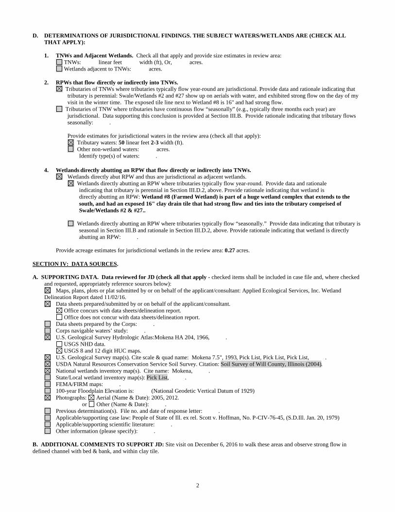
2
D. DETERMINATIONS OF JURISDICTIONAL FINDINGS. THE SUBJECT WATERS/WETLANDS ARE (CHECK ALL THAT APPLY):
1. TNWs and Adjacent Wetlands. Check all that apply and provide size estimates in review area:
TNWs: linear feet width (ft), Or, acres. Wetlands adjacent to TNWs: acres.
2. RPWs that flow directly or indirectly into TNWs.
Tributaries of TNWs where tributaries typically flow year-round are jurisdictional. Provide data and rationale indicating that tributary is perennial: Swale/Wetlands #2 and #27 show up on aerials with water, and exhibited strong flow on the day of my visit in the winter time. The exposed tile line next to Wetland #8 is 16" and had strong flow.
Tributaries of TNW where tributaries have continuous flow “seasonally” (e.g., typically three months each year) are jurisdictional. Data supporting this conclusion is provided at Section III.B. Provide rationale indicating that tributary flows seasonally: .
Provide estimates for jurisdictional waters in the review area (check all that apply): Tributary waters: 50 linear feet 2-3 width (ft). Other non-wetland waters: acres.
Identify type(s) of waters: .
4. Wetlands directly abutting an RPW that flow directly or indirectly into TNWs. Wetlands directly abut RPW and thus are jurisdictional as adjacent wetlands. Wetlands directly abutting an RPW where tributaries typically flow year-round. Provide data and rationale indicating that tributary is perennial in Section III.D.2, above. Provide rationale indicating that wetland is directly abutting an RPW: Wetland #8 (Farmed Wetland) is part of a huge wetland complex that extends to the
south, and had an exposed 16" clay drain tile that had strong flow and ties into the tributary comprised of Swale/Wetlands #2 & #27..
Wetlands directly abutting an RPW where tributaries typically flow “seasonally.” Provide data indicating that tributary is
seasonal in Section III.B and rationale in Section III.D.2, above. Provide rationale indicating that wetland is directly abutting an RPW: .
Provide acreage estimates for jurisdictional wetlands in the review area: 0.27 acres.
SECTION IV: DATA SOURCES. A. SUPPORTING DATA. Data reviewed for JD (check all that apply - checked items shall be included in case file and, where checked
and requested, appropriately reference sources below): Maps, plans, plots or plat submitted by or on behalf of the applicant/consultant: Applied Ecological Services, Inc. Wetland
Delineation Report dated 11/02/16. Data sheets prepared/submitted by or on behalf of the applicant/consultant.
Office concurs with data sheets/delineation report. Office does not concur with data sheets/delineation report.
Data sheets prepared by the Corps: . Corps navigable waters’ study: . U.S. Geological Survey Hydrologic Atlas:Mokena HA 204, 1966, .
USGS NHD data. USGS 8 and 12 digit HUC maps.
U.S. Geological Survey map(s). Cite scale & quad name: Mokena 7.5", 1993, Pick List, Pick List, Pick List, . USDA Natural Resources Conservation Service Soil Survey. Citation: Soil Survey of Will County, Illinois (2004). National wetlands inventory map(s). Cite name: Mokena, . State/Local wetland inventory map(s): Pick List, . FEMA/FIRM maps: . 100-year Floodplain Elevation is: (National Geodetic Vertical Datum of 1929) Photographs: Aerial (Name & Date): 2005, 2012.
or Other (Name & Date): . Previous determination(s). File no. and date of response letter: . Applicable/supporting case law: People of State of Ill. ex rel. Scott v. Hoffman, No. P-CIV-76-45, (S.D.Ill. Jan. 20, 1979) Applicable/supporting scientific literature: . Other information (please specify): .
B. ADDITIONAL COMMENTS TO SUPPORT JD: Site visit on December 6, 2016 to walk these areas and observe strong flow in defined channel with bed & bank, and within clay tile.
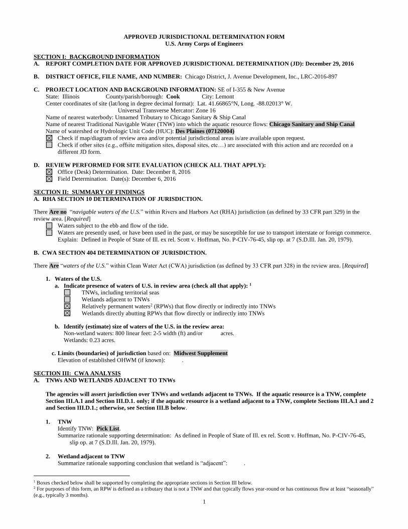
1
APPROVED JURISDICTIONAL DETERMINATION FORM
U.S. Army Corps of Engineers
SECTION I: BACKGROUND INFORMATION
A. REPORT COMPLETION DATE FOR APPROVED JURISDICTIONAL DETERMINATION (JD): December 29, 2016
B. DISTRICT OFFICE, FILE NAME, AND NUMBER: Chicago District, J. Avenue Development, Inc., LRC-2016-897
C. PROJECT LOCATION AND BACKGROUND INFORMATION: SE of I-355 & New Avenue
State: Illinois County/parish/borough: Cook City: Lemont
Center coordinates of site (lat/long in degree decimal format): Lat. 41.66865°N, Long. -88.02013° W.
Universal Transverse Mercator: Zone 16
Name of nearest waterbody: Unnamed Tributary to Chicago Sanitary & Ship Canal
Name of nearest Traditional Navigable Water (TNW) into which the aquatic resource flows: Chicago Sanitary and Ship Canal
Name of watershed or Hydrologic Unit Code (HUC): Des Plaines (07120004)
Check if map/diagram of review area and/or potential jurisdictional areas is/are available upon request.
Check if other sites (e.g., offsite mitigation sites, disposal sites, etc…) are associated with this action and are recorded on a
different JD form.
D. REVIEW PERFORMED FOR SITE EVALUATION (CHECK ALL THAT APPLY):
Office (Desk) Determination. Date: December 8, 2016
Field Determination. Date(s): December 6, 2016
SECTION II: SUMMARY OF FINDINGS
A. RHA SECTION 10 DETERMINATION OF JURISDICTION.
There Are no “navigable waters of the U.S.” within Rivers and Harbors Act (RHA) jurisdiction (as defined by 33 CFR part 329) in the
review area. [Required]
Waters subject to the ebb and flow of the tide.
Waters are presently used, or have been used in the past, or may be susceptible for use to transport interstate or foreign commerce.
Explain: Defined in People of State of Ill. ex rel. Scott v. Hoffman, No. P-CIV-76-45, slip op. at 7 (S.D.Ill. Jan. 20, 1979).
B. CWA SECTION 404 DETERMINATION OF JURISDICTION.
There Are “waters of the U.S.” within Clean Water Act (CWA) jurisdiction (as defined by 33 CFR part 328) in the review area. [Required]
1. Waters of the U.S.
a. Indicate presence of waters of U.S. in review area (check all that apply): 1
TNWs, including territorial seas
Wetlands adjacent to TNWs
Relatively permanent waters2 (RPWs) that flow directly or indirectly into TNWs
Wetlands directly abutting RPWs that flow directly or indirectly into TNWs
b. Identify (estimate) size of waters of the U.S. in the review area:
Non-wetland waters: 800 linear feet: 2-5 width (ft) and/or acres.
Wetlands: 0.23 acres.
c. Limits (boundaries) of jurisdiction based on: Midwest Supplement
Elevation of established OHWM (if known): .
SECTION III: CWA ANALYSIS
A. TNWs AND WETLANDS ADJACENT TO TNWs
The agencies will assert jurisdiction over TNWs and wetlands adjacent to TNWs. If the aquatic resource is a TNW, complete
Section III.A.1 and Section III.D.1. only; if the aquatic resource is a wetland adjacent to a TNW, complete Sections III.A.1 and 2
and Section III.D.1.; otherwise, see Section III.B below.
1. TNW
Identify TNW: Pick List.
Summarize rationale supporting determination: As defined in People of State of Ill. ex rel. Scott v. Hoffman, No. P-CIV-76-45,
slip op. at 7 (S.D.Ill. Jan. 20, 1979).
2. Wetland adjacent to TNW
Summarize rationale supporting conclusion that wetland is “adjacent”: .
1 Boxes checked below shall be supported by completing the appropriate sections in Section III below. 2 For purposes of this form, an RPW is defined as a tributary that is not a TNW and that typically flows year-round or has continuous flow at least “seasonally”
(e.g., typically 3 months).
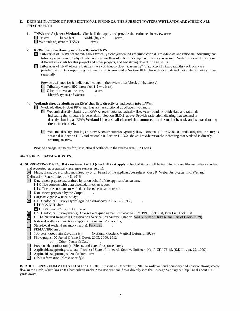
2
D. DETERMINATIONS OF JURISDICTIONAL FINDINGS. THE SUBJECT WATERS/WETLANDS ARE (CHECK ALL
THAT APPLY):
1. TNWs and Adjacent Wetlands. Check all that apply and provide size estimates in review area:
TNWs: linear feet width (ft), Or, acres.
Wetlands adjacent to TNWs: acres.
2. RPWs that flow directly or indirectly into TNWs.
Tributaries of TNWs where tributaries typically flow year-round are jurisdictional. Provide data and rationale indicating that
tributary is perennial: Subject tributary is an outflow of sidehill seepage, and flows year-round. Water observed flowing on 3
different site visits for this project and other projects, and had strong flow during all visits.
Tributaries of TNW where tributaries have continuous flow “seasonally” (e.g., typically three months each year) are
jurisdictional. Data supporting this conclusion is provided at Section III.B. Provide rationale indicating that tributary flows
seasonally: .
Provide estimates for jurisdictional waters in the review area (check all that apply):
Tributary waters: 800 linear feet 2-5 width (ft).
Other non-wetland waters: acres.
Identify type(s) of waters: .
4. Wetlands directly abutting an RPW that flow directly or indirectly into TNWs. Wetlands directly abut RPW and thus are jurisdictional as adjacent wetlands.
Wetlands directly abutting an RPW where tributaries typically flow year-round. Provide data and rationale
indicating that tributary is perennial in Section III.D.2, above. Provide rationale indicating that wetland is
directly abutting an RPW: Wetland 1 has a small channel that connects it to the main channel, and is also abutting
the main channel..
Wetlands directly abutting an RPW where tributaries typically flow “seasonally.” Provide data indicating that tributary is
seasonal in Section III.B and rationale in Section III.D.2, above. Provide rationale indicating that wetland is directly
abutting an RPW: .
Provide acreage estimates for jurisdictional wetlands in the review area: 0.23 acres.
SECTION IV: DATA SOURCES.
A. SUPPORTING DATA. Data reviewed for JD (check all that apply - checked items shall be included in case file and, where checked
and requested, appropriately reference sources below):
Maps, plans, plots or plat submitted by or on behalf of the applicant/consultant: Gary R. Weber Assoicates, Inc. Wetland
Delineation Report dated July 8, 2016.
Data sheets prepared/submitted by or on behalf of the applicant/consultant.
Office concurs with data sheets/delineation report.
Office does not concur with data sheets/delineation report.
Data sheets prepared by the Corps: .
Corps navigable waters’ study: .
U.S. Geological Survey Hydrologic Atlas:Romeoville HA 146, 1965, .
USGS NHD data.
USGS 8 and 12 digit HUC maps.
U.S. Geological Survey map(s). Cite scale & quad name: Romeoville 7.5", 1993, Pick List, Pick List, Pick List, .
USDA Natural Resources Conservation Service Soil Survey. Citation: Soil Survey of DuPage and Part of Cook (1979).
National wetlands inventory map(s). Cite name: Romeoville, .
State/Local wetland inventory map(s): Pick List, .
FEMA/FIRM maps: .
100-year Floodplain Elevation is: (National Geodetic Vertical Datum of 1929)
Photographs: Aerial (Name & Date): 2005, 2008, 2012.
or Other (Name & Date): .
Previous determination(s). File no. and date of response letter: .
Applicable/supporting case law: People of State of Ill. ex rel. Scott v. Hoffman, No. P-CIV-76-45, (S.D.Ill. Jan. 20, 1979)
Applicable/supporting scientific literature: .
Other information (please specify): .
B. ADDITIONAL COMMENTS TO SUPPORT JD: Site visit on December 6, 2016 to walk wetland boundary and observe strong steady
flow in the ditch, which has an 8'+ box culvert under New Avenue; and flows directly into the Chicago Sanitary & Ship Canal about 100
yards away.
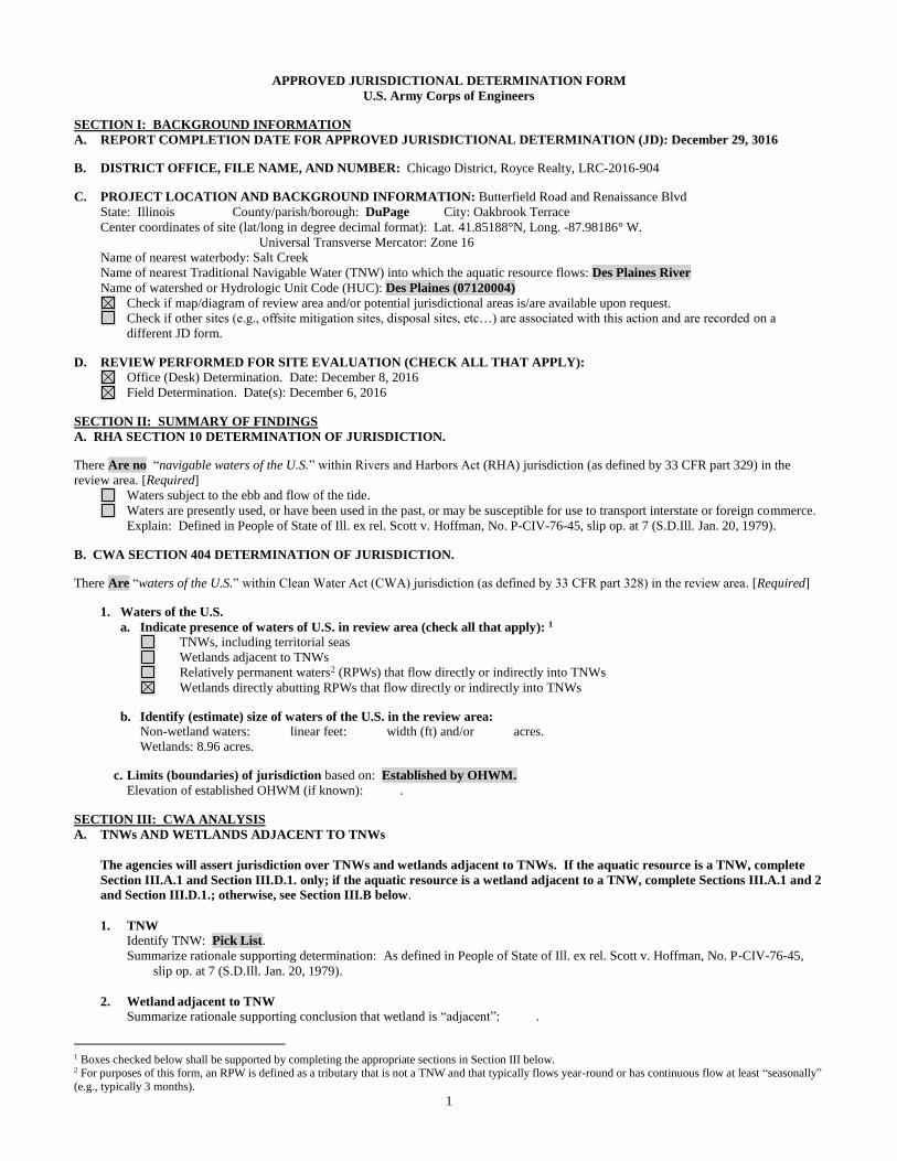
1
APPROVED JURISDICTIONAL DETERMINATION FORM
U.S. Army Corps of Engineers
SECTION I: BACKGROUND INFORMATION
A. REPORT COMPLETION DATE FOR APPROVED JURISDICTIONAL DETERMINATION (JD): December 29, 3016
B. DISTRICT OFFICE, FILE NAME, AND NUMBER: Chicago District, Royce Realty, LRC-2016-904
C. PROJECT LOCATION AND BACKGROUND INFORMATION: Butterfield Road and Renaissance Blvd
State: Illinois County/parish/borough: DuPage City: Oakbrook Terrace
Center coordinates of site (lat/long in degree decimal format): Lat. 41.85188°N, Long. -87.98186° W.
Universal Transverse Mercator: Zone 16
Name of nearest waterbody: Salt Creek
Name of nearest Traditional Navigable Water (TNW) into which the aquatic resource flows: Des Plaines River
Name of watershed or Hydrologic Unit Code (HUC): Des Plaines (07120004)
Check if map/diagram of review area and/or potential jurisdictional areas is/are available upon request.
Check if other sites (e.g., offsite mitigation sites, disposal sites, etc…) are associated with this action and are recorded on a
different JD form.
D. REVIEW PERFORMED FOR SITE EVALUATION (CHECK ALL THAT APPLY):
Office (Desk) Determination. Date: December 8, 2016
Field Determination. Date(s): December 6, 2016
SECTION II: SUMMARY OF FINDINGS
A. RHA SECTION 10 DETERMINATION OF JURISDICTION.
There Are no “navigable waters of the U.S.” within Rivers and Harbors Act (RHA) jurisdiction (as defined by 33 CFR part 329) in the
review area. [Required]
Waters subject to the ebb and flow of the tide.
Waters are presently used, or have been used in the past, or may be susceptible for use to transport interstate or foreign commerce.
Explain: Defined in People of State of Ill. ex rel. Scott v. Hoffman, No. P-CIV-76-45, slip op. at 7 (S.D.Ill. Jan. 20, 1979).
B. CWA SECTION 404 DETERMINATION OF JURISDICTION.
There Are “waters of the U.S.” within Clean Water Act (CWA) jurisdiction (as defined by 33 CFR part 328) in the review area. [Required]
1. Waters of the U.S.
a. Indicate presence of waters of U.S. in review area (check all that apply): 1
TNWs, including territorial seas
Wetlands adjacent to TNWs
Relatively permanent waters2 (RPWs) that flow directly or indirectly into TNWs
Wetlands directly abutting RPWs that flow directly or indirectly into TNWs
b. Identify (estimate) size of waters of the U.S. in the review area:
Non-wetland waters: linear feet: width (ft) and/or acres.
Wetlands: 8.96 acres.
c. Limits (boundaries) of jurisdiction based on: Established by OHWM.
Elevation of established OHWM (if known): .
SECTION III: CWA ANALYSIS
A. TNWs AND WETLANDS ADJACENT TO TNWs
The agencies will assert jurisdiction over TNWs and wetlands adjacent to TNWs. If the aquatic resource is a TNW, complete
Section III.A.1 and Section III.D.1. only; if the aquatic resource is a wetland adjacent to a TNW, complete Sections III.A.1 and 2
and Section III.D.1.; otherwise, see Section III.B below.
1. TNW
Identify TNW: Pick List.
Summarize rationale supporting determination: As defined in People of State of Ill. ex rel. Scott v. Hoffman, No. P-CIV-76-45,
slip op. at 7 (S.D.Ill. Jan. 20, 1979).
2. Wetland adjacent to TNW
Summarize rationale supporting conclusion that wetland is “adjacent”: .
1 Boxes checked below shall be supported by completing the appropriate sections in Section III below. 2 For purposes of this form, an RPW is defined as a tributary that is not a TNW and that typically flows year-round or has continuous flow at least “seasonally”
(e.g., typically 3 months).
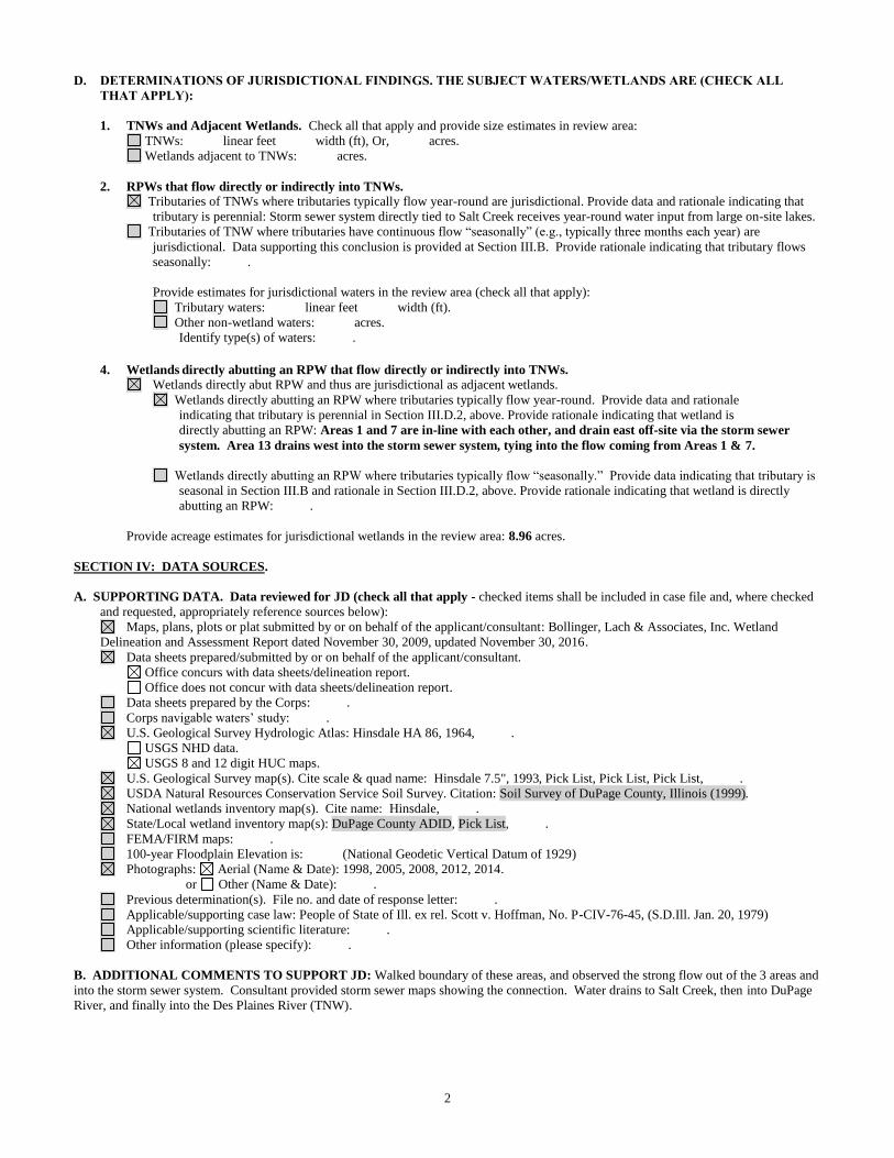
2
D. DETERMINATIONS OF JURISDICTIONAL FINDINGS. THE SUBJECT WATERS/WETLANDS ARE (CHECK ALL
THAT APPLY):
1. TNWs and Adjacent Wetlands. Check all that apply and provide size estimates in review area:
TNWs: linear feet width (ft), Or, acres.
Wetlands adjacent to TNWs: acres.
2. RPWs that flow directly or indirectly into TNWs.
Tributaries of TNWs where tributaries typically flow year-round are jurisdictional. Provide data and rationale indicating that
tributary is perennial: Storm sewer system directly tied to Salt Creek receives year-round water input from large on-site lakes.
Tributaries of TNW where tributaries have continuous flow “seasonally” (e.g., typically three months each year) are
jurisdictional. Data supporting this conclusion is provided at Section III.B. Provide rationale indicating that tributary flows
seasonally: .
Provide estimates for jurisdictional waters in the review area (check all that apply):
Tributary waters: linear feet width (ft).
Other non-wetland waters: acres.
Identify type(s) of waters: .
4. Wetlands directly abutting an RPW that flow directly or indirectly into TNWs. Wetlands directly abut RPW and thus are jurisdictional as adjacent wetlands.
Wetlands directly abutting an RPW where tributaries typically flow year-round. Provide data and rationale
indicating that tributary is perennial in Section III.D.2, above. Provide rationale indicating that wetland is
directly abutting an RPW: Areas 1 and 7 are in-line with each other, and drain east off-site via the storm sewer
system. Area 13 drains west into the storm sewer system, tying into the flow coming from Areas 1 & 7.
Wetlands directly abutting an RPW where tributaries typically flow “seasonally.” Provide data indicating that tributary is
seasonal in Section III.B and rationale in Section III.D.2, above. Provide rationale indicating that wetland is directly
abutting an RPW: .
Provide acreage estimates for jurisdictional wetlands in the review area: 8.96 acres.
SECTION IV: DATA SOURCES.
A. SUPPORTING DATA. Data reviewed for JD (check all that apply - checked items shall be included in case file and, where checked
and requested, appropriately reference sources below):
Maps, plans, plots or plat submitted by or on behalf of the applicant/consultant: Bollinger, Lach & Associates, Inc. Wetland
Delineation and Assessment Report dated November 30, 2009, updated November 30, 2016.
Data sheets prepared/submitted by or on behalf of the applicant/consultant.
Office concurs with data sheets/delineation report.
Office does not concur with data sheets/delineation report.
Data sheets prepared by the Corps: .
Corps navigable waters’ study: .
U.S. Geological Survey Hydrologic Atlas: Hinsdale HA 86, 1964, .
USGS NHD data.
USGS 8 and 12 digit HUC maps.
U.S. Geological Survey map(s). Cite scale & quad name: Hinsdale 7.5", 1993, Pick List, Pick List, Pick List, .
USDA Natural Resources Conservation Service Soil Survey. Citation: Soil Survey of DuPage County, Illinois (1999).
National wetlands inventory map(s). Cite name: Hinsdale, .
State/Local wetland inventory map(s): DuPage County ADID, Pick List, .
FEMA/FIRM maps: .
100-year Floodplain Elevation is: (National Geodetic Vertical Datum of 1929)
Photographs: Aerial (Name & Date): 1998, 2005, 2008, 2012, 2014.
or Other (Name & Date): .
Previous determination(s). File no. and date of response letter: .
Applicable/supporting case law: People of State of Ill. ex rel. Scott v. Hoffman, No. P-CIV-76-45, (S.D.Ill. Jan. 20, 1979)
Applicable/supporting scientific literature: .
Other information (please specify): .
B. ADDITIONAL COMMENTS TO SUPPORT JD: Walked boundary of these areas, and observed the strong flow out of the 3 areas and
into the storm sewer system. Consultant provided storm sewer maps showing the connection. Water drains to Salt Creek, then into DuPage
River, and finally into the Des Plaines River (TNW).
1
APPROVED JURISDICTIONAL DETERMINATION FORM
U.S. Army Corps of Engineers
SECTION I: BACKGROUND INFORMATION
A. REPORT COMPLETION DATE FOR APPROVED JURISDICTIONAL DETERMINATION (JD): January 18, 2017
B. DISTRICT OFFICE, FILE NAME, AND NUMBER: Chicago District, Oakbrook Hills C.C., LRC-2016-924
C. PROJECT LOCATION AND BACKGROUND INFORMATION: 3500 Midwest Road
State: Illinois County/parish/borough: DuPage City: Westmont
Center coordinates of site (lat/long in degree decimal format): Lat. 41.81995°N, Long. -87.97095° W.
Universal Transverse Mercator: Zone 16
Name of nearest waterbody: Lacey Creek
Name of nearest Traditional Navigable Water (TNW) into which the aquatic resource flows: Des Plaines River
Name of watershed or Hydrologic Unit Code (HUC): Des Plaines (07120004)
Check if map/diagram of review area and/or potential jurisdictional areas is/are available upon request.
Check if other sites (e.g., offsite mitigation sites, disposal sites, etc…) are associated with this action and are recorded on a
different JD form.
D. REVIEW PERFORMED FOR SITE EVALUATION (CHECK ALL THAT APPLY):
Office (Desk) Determination. Date: December 28, 2016
Field Determination. Date(s): December 27, 2016
SECTION II: SUMMARY OF FINDINGS
A. RHA SECTION 10 DETERMINATION OF JURISDICTION.
There Are no “navigable waters of the U.S.” within Rivers and Harbors Act (RHA) jurisdiction (as defined by 33 CFR part 329) in the
review area. [Required]
Waters subject to the ebb and flow of the tide.
Waters are presently used, or have been used in the past, or may be susceptible for use to transport interstate or foreign commerce.
Explain: Defined in People of State of Ill. ex rel. Scott v. Hoffman, No. P-CIV-76-45, slip op. at 7 (S.D.Ill. Jan. 20, 1979).
B. CWA SECTION 404 DETERMINATION OF JURISDICTION.
There Are “waters of the U.S.” within Clean Water Act (CWA) jurisdiction (as defined by 33 CFR part 328) in the review area. [Required]
1. Waters of the U.S.
a. Indicate presence of waters of U.S. in review area (check all that apply): 1
TNWs, including territorial seas
Wetlands adjacent to TNWs
Relatively permanent waters2 (RPWs) that flow directly or indirectly into TNWs
Wetlands directly abutting RPWs that flow directly or indirectly into TNWs
b. Identify (estimate) size of waters of the U.S. in the review area:
Non-wetland waters: linear feet: width (ft) and/or acres.
Wetlands: 8.27 acres.
c. Limits (boundaries) of jurisdiction based on: Midwest Supplement
Elevation of established OHWM (if known): .
SECTION III: CWA ANALYSIS
A. TNWs AND WETLANDS ADJACENT TO TNWs
The agencies will assert jurisdiction over TNWs and wetlands adjacent to TNWs. If the aquatic resource is a TNW, complete
Section III.A.1 and Section III.D.1. only; if the aquatic resource is a wetland adjacent to a TNW, complete Sections III.A.1 and 2
and Section III.D.1.; otherwise, see Section III.B below.
1. TNW
Identify TNW: Pick List.
Summarize rationale supporting determination: As defined in People of State of Ill. ex rel. Scott v. Hoffman, No. P-CIV-76-45,
slip op. at 7 (S.D.Ill. Jan. 20, 1979).
2. Wetland adjacent to TNW
Summarize rationale supporting conclusion that wetland is “adjacent”: .
1 Boxes checked below shall be supported by completing the appropriate sections in Section III below. 2 For purposes of this form, an RPW is defined as a tributary that is not a TNW and that typically flows year-round or has continuous flow at least “seasonally”
(e.g., typically 3 months).
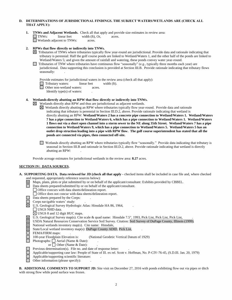
2
D. DETERMINATIONS OF JURISDICTIONAL FINDINGS. THE SUBJECT WATERS/WETLANDS ARE (CHECK ALL
THAT APPLY):
1. TNWs and Adjacent Wetlands. Check all that apply and provide size estimates in review area:
TNWs: linear feet width (ft), Or, acres.
Wetlands adjacent to TNWs: acres.
2. RPWs that flow directly or indirectly into TNWs.
Tributaries of TNWs where tributaries typically flow year-round are jurisdictional. Provide data and rationale indicating that
tributary is perennial: Half the golf course ponds are linked to Wetland/Waters 1, and the other half of the ponds are linked to
Wetland/Waters 5; and given the amount of rainfall and watering, these ponds convey water year-round.
Tributaries of TNW where tributaries have continuous flow “seasonally” (e.g., typically three months each year) are
jurisdictional. Data supporting this conclusion is provided at Section III.B. Provide rationale indicating that tributary flows
seasonally: .
Provide estimates for jurisdictional waters in the review area (check all that apply):
Tributary waters: linear feet width (ft).
Other non-wetland waters: acres.
Identify type(s) of waters: .
4. Wetlands directly abutting an RPW that flow directly or indirectly into TNWs. Wetlands directly abut RPW and thus are jurisdictional as adjacent wetlands.
Wetlands directly abutting an RPW where tributaries typically flow year-round. Provide data and rationale
indicating that tributary is perennial in Section III.D.2, above. Provide rationale indicating that wetland is
directly abutting an RPW: Wetland/Waters 2 has a concrete pipe connection to Wetland/Waters 1. Wetland/Waters
7 has a pipe connection to Wetland/Waters 6, which has a pipe connection to Wetland/Waters 1. Wetland/Waters
1 flows out via a short open channel into a storm sewer to the NE along 35th Street. Wetland/Waters 7 has a pipe
connection to Wetland/Waters 9, which has a pipe connection to Wetland/Waters 5. Wetland/Waters 5 has an
outlet drop struction leading into a pipe with RPW flow. The golf course superintendent has stated that all the
ponds are connected via pipes, then connected off-site.
Wetlands directly abutting an RPW where tributaries typically flow “seasonally.” Provide data indicating that tributary is
seasonal in Section III.B and rationale in Section III.D.2, above. Provide rationale indicating that wetland is directly
abutting an RPW: .
Provide acreage estimates for jurisdictional wetlands in the review area: 8.27 acres.
SECTION IV: DATA SOURCES.
A. SUPPORTING DATA. Data reviewed for JD (check all that apply - checked items shall be included in case file and, where checked
and requested, appropriately reference sources below):
Maps, plans, plots or plat submitted by or on behalf of the applicant/consultant: Exhibits provided by CBBEL.
Data sheets prepared/submitted by or on behalf of the applicant/consultant.
Office concurs with data sheets/delineation report.
Office does not concur with data sheets/delineation report.
Data sheets prepared by the Corps: .
Corps navigable waters’ study: .
U.S. Geological Survey Hydrologic Atlas: Hinsdale HA 86, 1964, .
USGS NHD data.
USGS 8 and 12 digit HUC maps.
U.S. Geological Survey map(s). Cite scale & quad name: Hinsdale 7.5", 1993, Pick List, Pick List, Pick List, .
USDA Natural Resources Conservation Service Soil Survey. Citation: Soil Survey of DuPage County, Illinois (1999).
National wetlands inventory map(s). Cite name: Hinsdale, .
State/Local wetland inventory map(s): DuPage County ADID, Pick List, .
FEMA/FIRM maps: .
100-year Floodplain Elevation is: (National Geodetic Vertical Datum of 1929)
Photographs: Aerial (Name & Date): .
or Other (Name & Date): .
Previous determination(s). File no. and date of response letter: .
Applicable/supporting case law: People of State of Ill. ex rel. Scott v. Hoffman, No. P-CIV-76-45, (S.D.Ill. Jan. 20, 1979)
Applicable/supporting scientific literature: .
Other information (please specify): .
B. ADDITIONAL COMMENTS TO SUPPORT JD: Site visit on December 27, 2016 with ponds exhibiting flow out via pipes or ditch
with strong flow while pond surface was frozen.