aquatic vegetation of osakis lake (dow 77-0215-00) todd ... · osakis lake has a surface area of...
TRANSCRIPT

Aquatic Vegetation of Osakis Lake (DOW 77-0215-00)
Todd County, Minnesota
May 23, 24, 26, 31 and June 1, 7, 12, 2006
Osakis Lake (77-0215-00), May 26, 2005
COPYRIGHT Minnesota Department of Natural Resources 2006

Aquatic vegetation of Osakis Lake (77-0215-00) Todd Co., 2006 ____________________________________________________________________________________________
Report by: Donna Perleberg
Minnesota Department of Natural Resources Division of Ecological Services 1601 Minnesota Dr., Brainerd, MN 56401 Phone: 218.833.8727 Fax: 218.828-6043
Email: [email protected] Lake sampling: Dan Swanson, Jeff Weite, Josh Knopik, Stephanie Loso, Lucas Wandrie, Joe Norman, and Matt Swanson
MnDNR Division of Ecological Services, Brainerd
Report Review: Wendy Crowell and Steve Enger, MnDNR Division of Ecological Services Jed Anderson, MnDNR Area Fisheries, Glenwood Funding: Collection of these data was made possible by support from the Heritage Enhancement
Fund.
This report should be cited as: Perleberg, D. 2006. Aquatic vegetation of Osakis Lake (DOW 77-0215-00) Todd County, Minnesota, May 23, 24, 26, 31 and June 1, 7, 12, 2006. Minnesota Department of Natural Resources, Ecological Services Division, 1601 Minnesota Dr., Brainerd, MN 56401. 17 pp.
Osakis Lake (77-0215-00), May 31, 2006
COPYRIGHT Minnesota Department of Natural Resources 2006 Page 2 of 17

Aquatic vegetation of Osakis Lake (77-0215-00) Todd Co., 2006 ____________________________________________________________________________________________
Summary This survey assessed the spring plant community of Osakis Lake (77-0215-00) in Todd County, central Minnesota. The zone from shore to a depth of 20 feet was sampled using a point-intercept, or grid, survey method. Within this area, 77 percent of the sample sites contained vegetation. The non-native, submerged plant, curly-leaf pondweed (Potamogeton crispus) dominated the plant community and was found in 46 percent of the survey sites. Curly-leaf pondweed was most common in water depths of 10 to 15 feet, where it occurred in 72 percent of the survey sites. It was one of the few plant species found in depths greater than nine feet and the only plant found in the 19 to 20 feet depth zone. Lower mid-summer water clarity in Osakis Lake likely restricts native aquatic plants to shallow water where they can obtain sufficient light. Native plants occurred in 43 percent of the sample sites. Sixteen native plant species were recorded and common species included bulrush (Scirpus sp.), star duckweed (Lemna trisulca), muskgrass (Chara sp.), coontail (Ceratophyllum demersum), and northern watermilfoil (Myriophyllum sibiricum). A mid-summer survey would be required to adequately assess the native plant community.
COPYRIGHT Minnesota Department of Natural Resources 2006 Page 3 of 17

Aquatic vegetation of Osakis Lake (77-0215-00) Todd Co., 2006 ____________________________________________________________________________________________
Introduction Figure 1. Osakis Lake (77-0215-00) Todd Co, MN
Osakis Lake (DOW 77-0215-00) is located in central Minnesota, along the border of Todd and Douglas Counties. The lake occurs within the ecological region called the Eastern Broadleaf Forest, which is the transition zone between the prairie lands of the southwest and the forested region of the northeast (Fig. 1). Osakis Lake is the headwaters of the Sauk River Watershed (Click here for a detailed map: Sauk River Watershed.) Flow enters Osakis Lake from several tributaries and outlets through the Sauk River, which drains the watershed to the south and east. The majority of land within this watershed has been converted to agriculture. The shoreline of Osakis Lake is heavily developed by both agricultural land and residential homes (Fig. 2).
# Osakis Lake#
Laurentian Mixed Forest
Prairie ParklandEastern Broadleaf
Forest
TallgrassAspen
Parklands
N
Osakis Lake has a surface area of about 6270 acres with a main, oval shaped basin and an elongated bay at its northeast end (Fig 2). The lake has a maximum depth of about 70 feet and approximately 54 percent of the basin is less than 15 feet in depth. Public boat launches occur at the south, west and northeast shores. A 1993 water quality study found that Osakis Lake had higher nutrient levels and lower water clarity than other lakes in central Minnesota and a watershed management project was implemented to improve lake water quality (Anon. 2004). Water quality appeared to have improved by 1998 (Anon. 2004) but the lake continues to experience periodic summer algal blooms. Between 1998 and 2004, mean summer water clarity, as measured by Secchi disc reading, ranged from 4.8 feet to 9.9 feet, with a mean of 7.4 feet (MPCA 2006). Historical surveys of Osakis Lake recorded extensive bulrush (Scirpus) stands in the southern basin and submerged vegetation scattered around the basin to a depth of about 15 feet in 1981 and to 12 feet in 1994. Common submerged species included coontail (Ceratophyllum demersum), wild celery (Vallisneria americana), muskgrass (Chara sp.), sago pondweed (Stuckenia pectinata), clasping-leaf pondweed (Potamogeton richardonsii), and water milfoil (Myriophyllum sp.) (MnDNR Fisheries Lake Files). The non-native submerged plant, curly-leaf pondweed (Potamogeton crispus) occurs in Osakis Lake. Within the Sauk RiverWatershed, curly-leaf pondweed has been documented in at least 47% of the lakes that are 100 acres or more in size (compiled by D. Perleberg using data available from MnDNR Invasive Species Program).
COPYRIGHT Minnesota Department of Natural Resources 2006 Page 4 of 17

Aquatic vegetation of Osakis Lake (77-0215-00) Todd Co., 2006 ____________________________________________________________________________________________
Figure 2. Depth contours of Osakis Lake (77-0215-00) Source: MnDNR 1969.
depth contour (feet) 60 50 40 30 20 15 10 5
0 500 1000 MetersN
Vegetation Survey Objectives The purpose of this vegetation survey was to describe the 2006 population of the non-native species, curly-leaf pondweed in Osakis Lake. Information on native vegetation was also recorded but most native plants do not reach maturity until mid to late summer. Specific objectives of this spring survey include:
1) Estimate the maximum depth of rooted vegetation 2) Estimate the percent of the lake occupied by rooted vegetation 3) Record the aquatic plant species that occur in the lake 4) Estimate frequencies of occurrence of individual species 5) Develop distribution maps for the common species
COPYRIGHT Minnesota Department of Natural Resources 2006 Page 5 of 17

Aquatic vegetation of Osakis Lake (77-0215-00) Todd Co., 2006 ____________________________________________________________________________________________
Methods A Point-Intercept vegetation survey of Osakis Lake was conducted on May 23, 24, 26, 31 and June 1, 7, 12, 2006. The surveys followed the methods described by Madsen (1999). Surveys included two survey crews, each consisting of one boat and two to three surveyors. Survey waypoints were created and downloaded into a Global Positioning System (GPS) receiver. Survey points were spaced 100 meters apart on Osakis Lake. In the field, surveyors sampled all survey points between shore and 20 feet for a total of 1601 sample sites (Fig. 3). The GPS unit was used to navigate the boat to each sample point. One side of the boat was designated as the sampling area. At each site, water depth was recorded in one foot increments using a measured stick in water depths less than eight feet and an electronic depth finder in water
Figure 3. 2006 vegetation survey points on Osakis (77-0215-00).
#S#S#S#S#S
#S#S#S#S#S#S#S
#S
#S#S#S#S#S#S#S
#S#S#S
#S#S#S#S#S
#S#S#S#S#S#S#S#S#S
#S#S#S#S#S
#S#S#S#S#S#S
#S#S#S#S#S#S#S#S#S
#S#S#S#S#S#S#S#S#S#S#S
#S#S#S#S#S#S#S#S
#S#S#S#S#S#S#S#S#S#S#S
#S#S#S#S#S#S#S#S#S#S#S#S#S#S#S#S#S#S#S#S#S
#S#S#S#S#S#S#S#S#S#S#S#S#S#S#S#S#S
#S#S#S#S#S#S#S#S#S#S#S#S#S#S#S#S#S#S#S#S#S#S
#S#S#S#S#S#S#S#S#S#S#S#S#S#S#S#S#S#S
#S#S#S#S#S#S#S#S#S#S#S#S#S#S#S#S#S#S#S#S#S#S#S
#S#S#S#S#S#S#S#S#S#S#S#S#S#S#S#S#S#S#S
#S#S#S#S#S#S
#S#S#S#S#S#S#S#S#S#S#S#S#S#S#S#S#S#S#S#S#S#S#S#S#S
#S#S#S#S#S#S
#S#S#S#S#S#S#S#S#S#S#S#S#S#S#S#S#S#S#S#S
#S#S#S#S#S#S#S#S#S#S
#S#S#S#S#S#S#S#S#S#S#S#S#S#S#S#S#S#S#S#S#S#S#S#S#S#S#S#S#S#S
#S#S#S#S#S#S#S#S
#S#S#S#S#S#S#S#S#S#S#S#S#S#S#S#S#S#S#S#S#S#S#S#S#S#S#S#S#S#S#S#S#S#S#S#S#S#S#S#S#S#S#S#S#S#S#S#S#S#S
#S#S#S#S#S#S#S
#S#S#S#S#S#S#S#S#S
#S
#S#S#S#S#S#S#S#S
#S#S#S#S#S#S#S#S#S#S#S#S#S#S#S#S#S#S#S#S#S#S#S#S#S#S#S#S#S#S#S#S#S#S#S#S#S#S#S#S#S#S#S#S#S#S#S#S#S#S
#S#S#S#S#S#S#S#S#S
#S#S#S#S
#S#S#S#S#S#S#S#S#S#S
#S#S#S#S#S#S#S#S#S#S#S#S#S#S#S#S#S#S#S#S#S#S#S#S#S#S#S#S#S#S#S#S#S#S#S#S#S#S#S#S#S#S#S#S#S#S#S#S#S#S#S#S
#S#S#S#S#S#S#S#S
#S#S#S
#S#S#S#S
#S#S#S#S#S#S#S#S#S#S#S#S
#S#S#S#S#S#S#S#S#S#S#S#S#S#S#S#S#S#S#S#S#S#S#S#S#S#S#S#S#S#S#S#S#S#S#S#S#S#S#S#S#S#S#S#S#S#S#S#S#S#S#S#S#S
#S#S#S#S#S#S#S#S#S#S#S#S#S#S
#S#S#S#S#S#S#S#S#S#S#S#S#S#S#S#S#S
#S#S#S#S#S#S#S#S#S#S#S#S#S#S#S#S#S#S#S#S#S#S#S#S#S#S#S#S#S#S#S#S#S#S#S#S#S#S#S#S#S#S#S#S#S#S#S#S#S#S#S#S
#S#S#S#S#S#S#S#S#S#S#S#S#S#S#S#S
#S#S#S#S#S#S#S#S#S#S#S#S#S#S#S#S#S#S
#S#S#S#S#S#S#S#S#S#S#S#S#S#S#S#S#S#S#S#S#S#S#S#S#S#S#S#S#S#S#S#S#S#S#S#S#S#S#S#S#S#S#S#S#S#S#S#S#S#S#S#S
#S#S#S#S#S#S#S#S#S#S#S#S#S#S#S#S
#S#S#S#S#S#S#S#S#S#S#S#S#S#S#S#S#S#S#S#S#S#S#S#S#S#S#S#S#S#S#S#S#S#S#S#S#S#S#S#S#S#S#S#S#S#S#S#S#S#S#S#S#S#S#S#S#S#S#S#S#S#S#S#S#S#S#S#S#S#S#S#S
#S#S#S#S#S#S#S#S#S#S#S#S#S#S#S#S#S
#S#S#S#S#S#S#S#S#S#S#S#S#S#S#S#S#S#S#S#S#S#S#S#S#S#S#S#S#S#S#S#S#S#S#S#S#S#S#S#S#S#S#S#S#S#S#S#S#S#S#S#S#S#S#S#S#S#S#S#S#S#S#S#S#S#S#S#S#S#S#S#S
#S#S#S#S#S#S#S#S#S#S#S#S#S#S#S#S#S
#S#S#S#S#S#S#S#S#S#S#S#S#S#S#S#S#S#S#S#S#S#S#S#S#S#S#S#S#S#S#S#S#S#S#S#S#S#S#S#S#S#S#S#S#S#S#S#S#S#S#S#S#S#S#S#S#S#S#S#S#S#S#S#S#S#S#S#S#S#S#S#S#S#S
#S#S#S#S#S#S#S#S#S#S#S#S#S#S#S
#S#S#S#S#S#S#S#S#S#S#S#S#S#S#S#S#S#S#S#S#S#S#S#S#S#S#S#S#S#S#S#S#S#S#S#S#S#S#S#S#S#S#S#S#S#S#S#S#S#S#S#S#S#S#S#S#S#S#S#S#S#S#S#S#S#S#S#S#S#S#S#S#S#S#S
#S#S#S#S#S#S#S#S#S#S#S#S#S#S
#S#S#S#S#S#S#S#S#S#S#S#S#S#S#S#S#S#S#S#S#S#S#S#S#S#S#S#S#S#S#S#S#S#S#S#S#S#S#S#S#S#S#S#S#S#S#S#S#S#S#S#S#S#S#S#S#S#S#S#S#S#S#S#S#S#S#S#S#S#S#S#S#S#S#S#S
#S#S#S#S#S#S#S#S#S#S#S#S#S#S#S
#S#S#S#S#S#S#S#S#S#S#S#S#S#S#S#S#S#S#S#S#S#S#S#S#S#S#S#S#S#S#S#S#S#S#S#S#S#S#S#S#S#S#S#S#S#S#S#S#S#S#S#S#S#S#S#S#S#S#S#S#S#S#S#S#S#S#S#S#S#S#S#S#S#S#S#S
#S#S#S#S#S
#S#S#S#S#S#S#S#S#S#S
#S#S#S#S#S#S#S#S#S#S#S#S#S#S#S#S#S#S#S#S#S#S#S#S#S#S#S#S#S#S#S#S#S#S#S#S#S#S#S#S#S#S#S#S#S#S#S#S#S#S#S#S#S#S#S#S#S#S#S#S#S#S#S#S#S#S#S#S#S#S#S#S#S#S#S#S#S
#S#S#S#S#S#S#S#S#S#S#S#S
#S#S#S#S#S#S#S#S#S#S#S#S#S#S#S#S#S#S#S#S#S#S#S#S#S#S#S#S#S#S#S#S#S#S#S#S#S#S#S#S#S#S#S#S#S#S#S#S#S#S#S#S#S#S#S#S#S#S#S#S#S#S#S#S#S#S#S#S#S#S#S#S#S#S#S
#S#S#S#S#S#S#S#S#S#S#S#S#S
#S#S#S#S#S#S#S#S#S#S#S#S#S#S#S#S#S#S#S#S#S#S#S#S
#S#S#S#S#S#S#S#S#S#S#S#S#S#S#S#S#S#S#S#S#S#S#S#S#S#S#S#S#S#S#S#S#S#S#S#S#S#S#S#S#S#S#S#S#S#S#S#S#S
#S#S#S#S#S#S#S#S#S#S#S#S#S
#S#S#S#S#S#S#S#S#S#S#S#S#S#S#S#S#S#S#S#S#S#S#S#S#S#S#S#S#S#S#S#S#S#S#S#S#S#S#S#S#S#S#S#S#S#S#S#S#S#S#S#S#S#S#S#S#S#S#S#S#S#S#S#S#S#S#S#S#S#S#S#S#S#S
#S#S#S#S#S#S#S#S#S#S#S#S
#S#S#S#S#S#S#S#S#S#S#S#S#S#S#S#S#S#S#S#S#S#S#S#S#S#S#S#S#S#S#S#S#S#S#S#S#S#S#S#S#S#S#S#S#S#S#S#S#S#S#S#S#S#S#S#S#S#S#S#S#S#S#S#S#S#S#S#S#S#S#S#S
#S#S#S#S#S#S#S#S#S#S#S
#S#S#S#S#S#S#S#S#S#S#S#S#S#S#S#S#S#S#S#S#S#S#S#S#S#S#S#S#S#S#S#S#S#S#S#S#S#S#S#S#S#S#S#S#S#S#S#S#S#S#S#S#S#S#S#S#S#S#S#S#S#S#S#S#S#S#S#S
#S#S#S#S#S#S#S
#S#S#S#S#S#S#S#S#S#S#S#S#S#S#S#S#S#S#S#S#S#S#S#S#S#S#S#S#S#S#S#S#S#S#S#S#S#S#S#S#S#S#S#S#S#S#S#S#S#S#S#S#S#S#S#S#S#S#S#S#S#S#S#S#S
#S#S#S#S#S#S#S#S#S#S#S#S#S#S#S#S#S#S#S#S#S#S#S#S#S#S#S#S#S#S#S#S#S#S#S#S#S#S#S#S#S#S#S#S#S#S#S#S#S#S#S#S#S#S#S#S#S#S#S#S#S#S
#S#S#S#S#S#S#S#S#S#S#S#S#S#S#S#S#S#S#S#S#S#S#S#S#S#S#S#S#S#S#S#S#S#S#S#S#S#S#S#S#S#S#S#S#S#S#S#S#S#S#S#S#S#S#S#S#S#S#S#S
#S#S#S#S#S#S#S#S#S#S#S#S#S#S#S#S#S#S#S#S#S#S#S#S#S#S#S#S#S#S#S#S#S#S#S#S#S#S#S#S#S#S#S#S#S#S#S#S#S#S#S#S#S#S#S#S#S
#S#S#S#S#S#S#S#S#S#S#S#S#S#S#S#S#S#S#S#S#S#S#S#S#S#S#S#S#S#S#S#S#S#S#S#S#S#S#S#S#S#S#S#S#S#S#S#S#S#S#S#S#S#S
#S#S#S#S#S#S#S#S#S#S#S#S#S#S#S#S#S#S#S#S#S#S#S#S#S#S#S#S#S#S#S#S#S#S#S#S#S#S#S#S#S#S#S#S#S#S#S#S#S#S#S#S
#S#S#S#S#S#S#S#S#S#S#S#S#S#S#S#S#S#S#S#S#S#S#S#S#S#S#S#S#S#S#S#S#S#S#S#S#S#S#S#S#S#S#S#S#S#S#S#S#S#S
#S#S#S#S#S#S#S#S#S#S#S#S#S#S#S#S#S#S#S#S#S#S#S#S#S#S#S#S#S#S#S#S#S#S#S#S#S#S#S#S#S#S#S#S#S#S#S#S#S#S
#S#S#S#S#S#S#S#S#S#S#S#S#S#S#S#S#S#S#S#S#S#S#S#S#S#S#S#S#S#S#S#S#S#S#S#S#S#S#S#S#S#S#S#S#S#S#S#S#S
#S#S#S#S#S#S#S#S#S#S#S#S#S#S#S#S#S#S#S#S#S#S#S#S#S#S#S#S#S#S#S#S#S#S#S#S#S#S#S#S#S#S#S#S#S#S#S#S#S
#S#S#S#S#S#S#S#S#S#S#S#S#S#S#S#S#S#S#S#S#S#S#S#S#S#S#S#S#S#S#S#S#S#S#S#S#S#S#S#S#S#S#S#S#S
#S#S
#S#S#S#S#S#S#S#S#S#S#S#S#S#S#S#S#S#S#S#S#S#S#S#S#S#S#S#S#S#S#S#S#S#S#S#S#S#S#S#S#S
#S#S
#S#S#S#S#S#S#S#S#S#S#S#S#S#S#S#S#S#S#S#S#S#S#S#S#S#S#S#S#S#S#S#S#S#S#S#S#S#S#S
#S
#S#S#S#S#S#S#S#S#S#S#S#S#S#S#S#S#S#S#S#S#S#S#S#S#S
#S
#S#S#S#S#S#S#S#S#S#S#S#S#S#S#S#S#S#S#S#S#S#S#S
#S#S#S#S#S#S#S#S#S#S#S#S#S#S#S#S#S#S
#S#S#S#S#S
#S 2006 vegetation survey sites
water depth >20 ft (no survey)
0 500 1000 Meters
N
COPYRIGHT Minnesota Department of Natural Resources 2006 Page 6 of 17

Aquatic vegetation of Osakis Lake (77-0215-00) Todd Co., 2006 ____________________________________________________________________________________________
depths greater than eight feet. The surveyors recorded all plant species found within a one meter squared sample site at the pre-designated side of the boat. A double-headed, weighted garden rake, attached to a rope was used to survey vegetation not visible from the surface (Fig. 4). Nomenclature followed Crow and Hellquist (2000). Voucher specimens were collected for most plant species and are stored at the MnDNR in Brainerd. Data were entered into a Microsoft Access database and frequency of occurrence was calculated for each species as the number of sites in which a species occurred divided by the total number of sample sites.
Figure 4. Sampling vegetation on Osakis Lake, June 1, 2006.
Example: In Osakis Lake there were 1601 samples sites in the zone from shore to the 20 feet depth. Curly-leaf pondweed occurred in 741 of those sites. Frequency of curly-leaf pondweed in the shore to 20 feet depth zone of Osakis Lake
= 741/1601 (*100) = 46% Frequency was calculated for the entire area from shore to 20 feet and sampling points were also grouped by water depth and separated into seven depth zones for analysis (Table 1).
Results Table 1. Sampling effort by water depth zone Osakis Lake (77-0215-00). Distribution and plants with water depth Aquatic plants were found to a maximum depth of 20 feet (the maximum depth sampled) in Osakis Lake and 77 percent of the sample sites within that depth interval contained vegetation. Plant abundance was greatest from shore to a water depth of 15 feet depth; in depths greater than 15 feet, only 40 percent of sites were vegetated (Fig. 5).
Depth interval in feet
Number of sample points
0 to 3 1654 to 6 3087 to 9 460
10 to 12 31313 to 15 21416 to 18 104
19 to 20 37Total number of sample points
1601
COPYRIGHT Minnesota Department of Natural Resources 2006 Page 7 of 17

Aquatic vegetation of Osakis Lake (77-0215-00) Todd Co., 2006 ____________________________________________________________________________________________
Figure 5. Frequency of vegetation vs. water depth, Osakis Lake (77-0215-00). May-June, 2006
0%
20%
40%
60%
80%
100%
0 to 3 4 to 6 7 to 9 10 to 12 13 to 15 16 to 18 19 to 20
Water Depth (ft)
Perc
ent o
f Site
s w
ith V
eget
atio
n
Number and types of plant species recorded Curly-leaf pondweed, (Potamogeton crispus), a non-native, submerged aquatic plant species was documented in Osakis Lake. A total of 16 native aquatic plant species were also recorded including 12 submerged, two free-floating, and two emergent plants (Table 2). Emergent species and most submerged species were restricted to water depths less than ten feet (Fig. 6). Curly-leaf pondweed was the only species found in depths greater than 18 feet.
Figure 6. Number of plant species vs. water depth. Osakis Lake (77-0215-00). May-June, 2006
0
5
10
15
0 to 3 4 to 6 7 to 9 10 to 12 13 to 15 16 to 18 19 to 20
water depth (ft)
num
ber o
f spe
cies
free-f loating
submerged
emergent
COPYRIGHT Minnesota Department of Natural Resources 2006 Page 8 of 17

Aquatic vegetation of Osakis Lake (77-0215-00) Todd Co., 2006 ____________________________________________________________________________________________
Table 1. Aquatic Plants of Osakis Lake (Todd County). May 23, 24, 26, 31 and June 1, 7, 12, 2006.
Frequency calculated for zone from shore to 20 feet depth Frequency = percent of sites in which species occurred
Common name Scientific name 2006 % Curly Leaf Pondweed Potamogeton crispus 46Muskgrass Chara sp. 11Northern watermilfoil Myriophyllum sibiricum 7Coontail Ceratophyllum demersum 7Flatstem pondweed Potamogeton zosteriformis 2
Whitestem pondweed Potamogeton praelongus 1
Clasping-leaf pondweed Potamogeton richardsonii 1
Narrowleaf pondweed Potamogeton sp. 1Subm
erge
d
Stuckenia pectinata Sago pondweed 1
Heteranthera dubia Water stargrass 1
Najas flexilis Bushy pondweed 1
Vallisneria americana Wild Celery <1
Elodea canadensis Canada waterweed <1 Lemna trisulca Star Duckweed 18Free-
floating Nitella sp. Stonewort 5
Scirpus sp. Bulrush 9Emergent Typha sp. Cattail 1
Total number of species 17
COPYRIGHT Minnesota Department of Natural Resources 2006 Page 9 of 17
Aquatic vegetation of Osakis Lake (77-0215-00) Todd Co., 2006 ____________________________________________________________________________________________
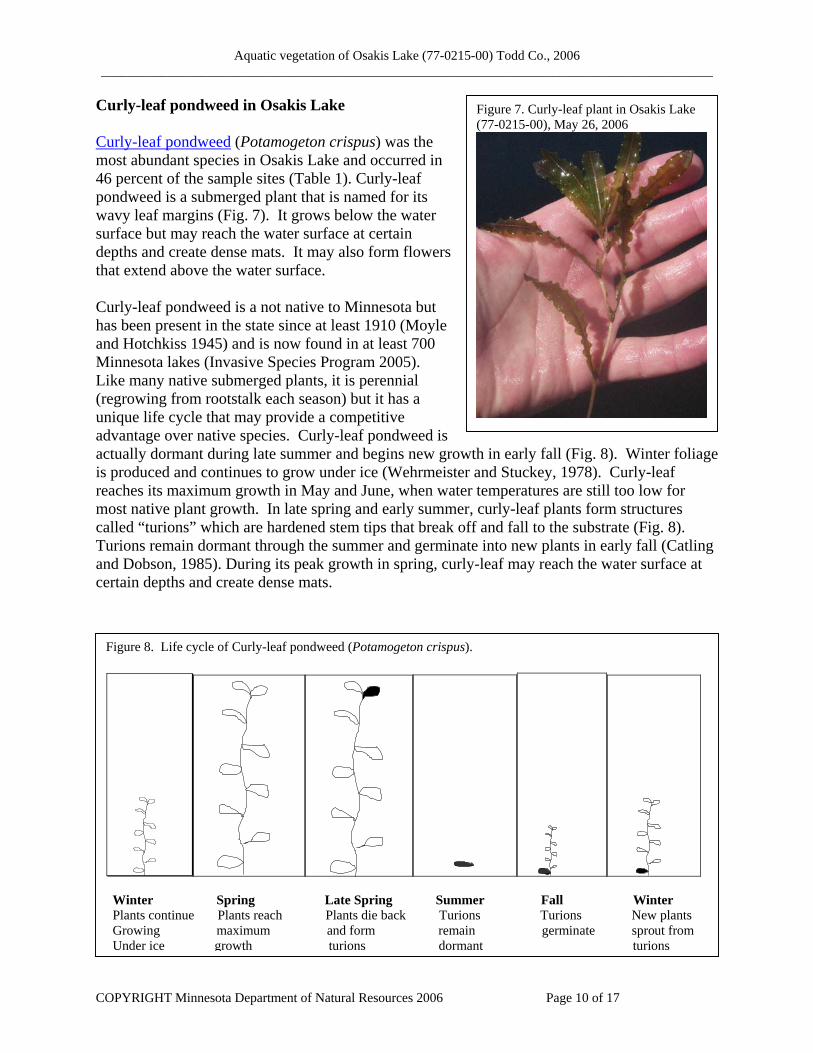
Curly-leaf pondweed in Osakis Lake Curly-leaf pondweed (Potamogeton crispus) was the most abundant species in Osakis Lake and occurred in 46 percent of the sample sites (Table 1). Curly-leaf pondweed is a submerged plant that is named for its wavy leaf margins (Fig. 7). It grows below the water surface but may reach the water surface at certain depths and create dense mats. It may also form flowers that extend above the water surface. Curly-leaf pondweed is a not native to Minnesota but has been present in the state since at least 1910 (Moyle and Hotchkiss 1945) and is now found in at least 700 Minnesota lakes (Invasive Species Program 2005). Like many native submerged plants, it is perennial (regrowing from rootstalk each season) but it has a unique life cycle that may provide a competitive advantage over native species. Curly-leaf pondweed is actually dormant during late summer and begins new growth in early fall (Fig. 8). Winter foliage is produced and continues to grow under ice (Wehrmeister and Stuckey, 1978). Curly-leaf reaches its maximum growth in May and June, when water temperatures are still too low for most native plant growth. In late spring and early summer, curly-leaf plants form structures called “turions” which are hardened stem tips that break off and fall to the substrate (Fig. 8). Turions remain dormant through the summer and germinate into new plants in early fall (Catling and Dobson, 1985). During its peak growth in spring, curly-leaf may reach the water surface at certain depths and create dense mats.
Figure 7. Curly-leaf plant in Osakis Lake (77-0215-00), May 26, 2006
Figure 8. Life cycle of Curly-leaf pondweed (Potamogeton crispus).
Winter Spring Late Spring Summer Fall Winter Plants continue Plants reach Plants die back Turions Turions New plants Growing maximum and form remain germinate sprout from Under ice growth turions dormant turions
COPYRIGHT Minnesota Department of Natural Resources 2006 Page 10 of 17

Aquatic vegetation of Osakis Lake (77-0215-00) Todd Co., 2006 ____________________________________________________________________________________________
During the spring of 2006, curly-leaf pondweed occurred at all depth sampled in Osakis Lake, but it dominated the plant community in water depths from seven to 20 feet (Fig. 9). In depths less than seven feet, curly-leaf occurred in less than 20 percent of the sample sites and it reached it’s maximum frequency in the 10 to 15 feet water depth, where it occurred in 72 percent of the sample sites (Fig. 9).
Figure 9. Frequency of common plant species by water depth. Osakis Lake (77-0215-00), May-June 2006.
0%
20%
40%
60%
80%
100%
0 to 3 4 to 6 7 to 9 10 to 12 13 to 15 16 to 18 19 to 20
Water Depth (ft)
Freq
uenc
y of
Occ
urre
nce
Bulrush
Star Duckweed
Curly Leaf Pondweed
Chara
Northern Milfoil
Coontail
The southwest and west-central ends of Osakis Lake have extensive areas within the seven to 20 feet water depth range and curly-leaf was well distributed in those areas (Fig. 10). Curly leaf was often the only species found in depth greater than 13 feet (Fig. 9) and 34 percent of all survey sites contained only curly-leaf pondweed (Fig. 10).
COPYRIGHT Minnesota Department of Natural Resources 2006 Page 11 of 17

Aquatic vegetation of Osakis Lake (77-0215-00) Todd Co., 2006 ____________________________________________________________________________________________
Figure 10. Types of vegetation found in Osakis Lake (77-0215-00), May-June 2006.
$
$
$
$$
$$
$
$$
$$$
$$$$$$
$
###S#
#S
#S###S##
#S
##S#S#S##S
###
#####
##S#S#
#S
#S####
#####
#
#
#S#S
##S
#######
#
#S#S#
#
###
#
##
#
#
#
#########
####
S
####
#S#
#S#S#S#S###
#
#
########
#S
##
#
######S###
#S##
##
#
#####
#
#
S
###
#
#S####
#
#############
######
####
###S###
###
#S#
###########
#S#####
##S##S
#S#S##
########S
##
#
#
#S
#
#
########
#S##S##
############
##S#
###S#S###
#
###########S
###
#S
#
#
#S##
##
####
#S#S##
###S####
#S#
#
######
###
#
######S#S############S
#
####
###
#
#
####
###S#S#S#####
###S#S#
#S##
#
#
################S##########
#S###S##
#S#S
#S
#####
####
###
######S####
##S##S
#S
S
####S#S#######
#S####S#S
#S#####
##########S
#S###
#S##S
##
########
#S##S####
###
#
S
#
#####################S#
##S#S
S
###S####
###
#S###S
###S###S#
#
####
############
#####
S#S
##
#############S
###
##
###S#S########S#########
########
S
#
#
#
#
###########
##
##
#
#
###S#
#S
S#
#
########
#################
####
#S
#
######
###S
##
#
#
S
#
###S#S#S#S################S##
########S
#
######
###
##S
#
#S
##S#S#
#S#S#
#S
#######S#####
######
#
############
#S##
##
###
#S##
#S##S####S
S
##########
#S##############S
#S###
##S
S##
#S
##
##S#
#S
#
####
#S
###
##S##
#S#
####S##########
########
###
####
#S
####S
##
####
##S
#
#S
#S#S
#
##
#
##S#S##
#S#S#
####S############
######
#
###
#S#S##
#S
#S
##
####
#
#S#
##S#S#S#S
##
######
#S#S##########
####
#
###S
##S####
#
#
###S#S#S
####
###S
#S#
#S#S#S
#S#
#S#######S##S
#S##########
##
##
#S
#S
####
#S
#
###
#S#S##
####
###S
#
##S#
#S#
####
#S#S####
######
#####
#
###S
####
#S#S
#S#############
###S
#S
#
#
#S
#S#
#S###########
#S
####
#S####
#S
#S
#S
##S#####
###S
S###########
####
#S#S
#S#
#S#S
#S
#
#S#####
#S####
##
###S
##
#S#####
#S############
#######
#S#
#
##########
#
#
#S
S#S
#S#################
#S#S####
##S#
###S#
#S
#S##
####
#S#######
#S
#S#
#S###S
#S#S#####S
#S##S###########
##
#S#S#
#S####S
######S#########
#S
#S
#S
#S#S#
##S#
S
###S#
###S###
#######
#S###
S
#
#
#S##S##########
#S#
#S#S
#S
##S
#S#S
#S
###S#########
#S#
#S
S
#S
###S#S
#S#S#######S#S####
##S
S
#S#S
##
#S
#S#S
#S#S#S
S
#S
####S##########
#S##
#S
#S#S#S#S#S#S#S#S#S#
#S#######
#S#
#S###
#S
#S#S#S#S#S#S#S#S###########
#S#
##
S#S#S
##
#S#S#S#S#S#S#S#####
#S#S#S#
#S####
##
#S#S#
#S
#S#S
#S#S#S#S#S#S#S#S#####
#S#######
#
#
#S
##S#S
#S
#S###S#S#
#S#S#S#S#S#S#S#S#S#S#S#S#
#S
#S#S#S
#S#S#S#S#
#S#S#S#S#S#S#S#
#S##S#S#
###S###S##########
#S##S##
S
#S
#S#S#
$ shallow site with emergents (not surveyed)
20 ft depth contour
curly-leaf pondweed # native vegetation# mixed curly-leaf and natives#S no vegetation
#
N
0 300 600 Meters
no vegetation
23%
natives only30%
natives and curly-leaf
13%
curly-leaf pondweed
only34%
COPYRIGHT Minnesota Department of Natural Resources 2006 Page 12 of 17

Aquatic vegetation of Osakis Lake (77-0215-00) Todd Co., 2006 ____________________________________________________________________________________________
Native vegetation in Osakis Lake Native vegetation was found in 43 percent of the sample sites but was primarily restricted to water depths less than 10 feet (Fig. 8). Areas dominated by native vegetation included the eastern shore and southwestern shores (Fig. 9). It is important to remember that this survey aimed to estimate the abundance and distribution of curly-leaf pondweed. For an accurate assessment of the native plant community, a mid-summer survey would be required. During an August, 2006 fisheries survey, DNR staff noted extensive stands of wild celery (Vallisneria americana). Bulrush (Scirpus sp.) formed extensive beds along the western and east-central shores of Osakis Lake (Fig. 11). Although it was found in only nine percent of the sample sites (Table 2) bulrush is one of the more common species in the lake. It occurred at numerous sites that were too shallow to sample and its actual abundance in the lake is greater than what is recorded by this survey method. Star duckweed (Lemna trisulca) was the most common native species found in sample sites and occurred in 18 percent of the sites (Table 2). It is a free-floating species that is often found submerged but not anchored to the lake bottom and it can drift with water currents. It was one of the few native species found in depths of ten feet and greater, but was most common from shore to a depth of six feet (Fig. 9) and was widely distributed around the lake (Fig. 11). Muskgrass (Chara sp.) occurred in 11 percent of the sample sites (Table 2) and was only found in depths of 12 feet and less (Fig. 9). Muskgrass is a submerged, macroscopic algae that is common in many hardwater Minnesota lakes. It is named for its characteristic musky odor. Because this species does not form true stems, it is a low-growing plant, often found entirely beneath the water surface where it may form low “carpets” on the lake bottom. Muskgrass is adapted to variety of substrates and is often the first species to invade open areas of lake bottom where it can act as a sediment stabilizer. In Osakis Lake, muskgrass was often found at sandy sites where curly-leaf pondweed did not occur (Fig. 11). Coontail (Ceratophyllum demersum) was present in seven percent of the sample sites (Table 2) and most common in depths less than 10 feet (Fig. 9). This perennial grows entirely submerged and is adapted to a broad range of lake conditions, including turbid water. It is often found growing in deeper water than other native species because it is more tolerant of low light conditions. In Osakis Lake, coontail was one of the few native species found in depths greater than 10 feet but it was only found in a few of these deeper water sites. Coontail was most often found in protected bays of Osakis Lake (Fig. 11) Northern watermilfoil (Myriophyllum sibiricum) occurred in seven percent of the sample sites (Table 2) and was most common in depths of six feet and less (Fig. 9). It was found in the northeast bay, the southwest end of the lake, and scattered along other shores (Fig. 11). This perennial submerged species prefers soft substrates and is not tolerant of turbidity. All other native species were present in less than six percent of the sample sites (Table 2).
COPYRIGHT Minnesota Department of Natural Resources 2006 Page 13 of 17

Aquatic vegetation of Osakis Lake (77-0215-00) Todd Co., 2006 ____________________________________________________________________________________________
Figure 11. Distribution of common plant species in Osakis Lake (77-0215-00), May-June, 2006.
#
###
##
#
#####
#
#########
#
#
##
#
#
#
#
#
###
##
#
##
#
####
#
#
#
#
#
#
####
###
#
###
###
###
##
##
##
#
#
#####
#######
#
#
####
##
####
#
#
#######
#
##
########
#
##
#
#
####
###
#
####
#
######
#
#
#
#
###
########
##
####
##
#
####
#
##
#####
#
##
######
#
##
##
#
#
######
#
####
##
#
#
###
#
#
#####
##
##
##
#
##
##
#
#####
#
#
##
#
#
#
#########
#
#####
##
#
#
##
#
##
#
#
#
###
#
#
#
####
#
##
#
#
#
####
#
##
#
##
###
#
#
#
#####
#
#
#####
###
###
#
#
######
####
#
###
#
####
##
####
###
#####
#
######
#####
#
#######
#######
####
#####
##
####
##
####
####
######
########
#
####
######
#
#####
#
##
#
#
##
#
#
#
#
#
#
#
###
#
#####
#
##
####
##
#
#
#
####
#
#
###
#
#
#
####
#
###
##
#######
#
#
###
#
####
###
#
###
#
##
#
#
#
##
#
#
#
##
#
###
#
###
#
###
#
#
##
###
###
###
#
#
##
#
####
#
###
######
#
###
##
#
#
#
#
##
#
##
#
##
###
#
#
#####
##
#####
#
##
#
#
#
#
##
###
#
##
#########
#
##
#
#
##########
#####
########
###
####
###
##
#####
#
##
#
##
##
##
#
##
###
######
#
#
##
####
#
##
#
##
#
#
##
#
##
###
##
#
#
#
#
###
#
##
#
##
###
##
#
###
###
###
##
##
##
##
#
#
#
#
#
##
#
#
#
####
###
##
##
#
#
#
#
#
#
# #####
#
############
#
#
Star duckweed (Lemna trisulca) 16%
Muskgrass(Chara sp.)11%
Coontail(Ceratophyllum demersum)7%
NorthernWatermilfoil(Myriophyllumsibiricum)7%
Bulrush(Scirpus sp.)9%
20 ft contour
N
##
##
####
###
##
###
###
#########
##
########
########
#
#
########
####
#
#
#######
###
##
##############
#
###
#
###############
#
##
#
################
####
##
####
#
################################
#
#
#
#############################
#
#
############
#############
####
###
#
###########################
#
#
##
####
#######
############
#
###
#
#####
################
##
#
#
##
########
##############
##
#
##
#
#############
############
##
#
#############
###############
##
##
#
##############
########
##
##
#
######
####
####################
#####
###
#
#######
###
#################
####
##
##
###
###
#
######
#########
##
######
#
###
##
#
##############
##
#####
####
##
#
##
################
##
####
#####
###
##
#
###########
######
######
####
###
##
###########
####
######
######
##########
#
######
#########
####
#
####
####
###
#
#####
####
##
##
#
#
#
##
###
#
##
#
#
Curly-leaf pondweed(Potamogeton crispus)47%
0 800 1600 Meters
COPYRIGHT Minnesota Department of Natural Resources 2006 Page 14 of 17

Aquatic vegetation of Osakis Lake (77-0215-00) Todd Co., 2006 ____________________________________________________________________________________________
Discussion Curly-leaf pondweed is probably not a recent invader in Osakis Lakes. It has been present in Minnesota for at least 100 years and common in central Minnesota lakes for at least the past 20 years. It is difficult to know when it first invaded Osakis Lake because historical plant surveys were conducted in mid to late summer, after curly-leaf would have already died. Spring water clarity in Osakis Lake has reportedly increased in the past few years (possibly due to watershed management improvements and/or lack of snow cover) and that may have allowed an increase in curly-leaf pondweed growth. Rooted aquatic plants are generally restricted to water depths where they can obtain sufficient sunlight for growth. As a general rule, native plants may grow to a depth of about twice the mid-summer Secchi Disc reading. In Osakis Lake, plants would not be expected to grow beyond a depth of 15 feet. Curly-leaf pondweed, however, can take advantage of relatively clear water in the spring before native species are present, and it therefore is found growing in deeper water. As curly-leaf dies back in early summer, water clarity may further decline as the dying curly-leaf releases nutrients that may result in increased algal growth. All vegetation, native and non-native can benefit a lake by providing habitat for fish and invertebrates, buffering the shorelines from wave action, stabilizing sediments and utilizing nutrients that would otherwise be available for algae. Native vegetation can be of greater value because it has coevolved with the native fish and wildlife species that utilize the lake. (Click here for more information on: value of aquatic plants ). Curly-leaf pondweed has the potential to cause recreational problems on lakes, particularly if it forms extensive surface mats that interfere with boat use. These problems are temporary because the plant typically dies back by early July. Longer-term ecological problems may occur if extensive stands of curly-leaf form annually and contribute significant nutrient loads to the lake. For more information on management of curly-leaf pondweed see page 51 in this report: MnDNR Invasive Species Annual Report Monitoring changes in aquatic plant community The types and amounts of aquatic vegetation that occur within a lake are influenced by a variety of factors including water clarity and water chemistry. Monitoring change in the aquatic plant community can be helpful in determining whether changes in the lake water quality are occurring and for estimating the quality of vegetation habitat available for fish and wildlife communities. Data from the 2006 vegetation survey can also be used to monitor annual changes in curly-leaf pondweed plant species composition. Again, a mid-summer survey would be helpful to monitor change in the native plant community. In general, factors that may lead to change in native and non-native aquatic plant communities include: • Change in water clarity
If water clarity in Osakis Lake increases, submerged vegetation is expected to expand in distribution and grow at greater water depths.
COPYRIGHT Minnesota Department of Natural Resources 2006 Page 15 of 17

Aquatic vegetation of Osakis Lake (77-0215-00) Todd Co., 2006 ____________________________________________________________________________________________
• Snow and ice cover Curly-leaf pondweed, in particular, may fluctuate in abundance in response to snow cover. Many native submerged plants also have the ability to grow under the ice, especially if there is little snow cover and sunlight reaches the lake bottom. In years following low snow cover, and/or a reduced ice-over period, curly-leaf and some native submerged plants may increase in abundance.
• Water temperatures / length of growing season In years with cool spring temperatures, submerged plants may be less abundant than in years with early springs and prolonged warm summer days.
• Natural fluctuation in plant species. Many submerged plants are perennial and regrow in similar locations each year. However, a few species such as bushy pondweed (Najas flexilis) are annuals and are dependant on the previous years seed set for regeneration.
• Aquatic plant management activities Humans can impact aquatic plant communities directly by destroying vegetation with herbicide or by mechanical means. For information on the laws pertaining to aquatic plant management: MnDNR APM Program. Motorboat activity in vegetated areas can be particularly harmful for species such as bulrush. Shoreline and watershed development can also indirectly influence aquatic plant growth if it results in changes to the overall water quality and clarity. Herbicide and mechanical control of aquatic plants can directly impact the aquatic plant community. Monitoring these control activities can help insure that non-target species are not negatively impacted.
COPYRIGHT Minnesota Department of Natural Resources 2006 Page 16 of 17

Aquatic vegetation of Osakis Lake (77-0215-00) Todd Co., 2006 ____________________________________________________________________________________________
Literature Cited Anonymous. 2004. Osakis Lake Watershed Management Project Continuations: Final Report.
A Clean Water Partnership Project. Submitted by Sauk River Watershed District. June 2004. 30 pp. available online at: http://www.srwdmn.org/wqreports.html
Catling, P.M. and I. Dobson. 1985. The biology of Canadian weeds. 69. Potamogeton crispus L.
Canadian Journal of Plant Science 65:655-668. Crow, G.E. and C.B. Hellquist. 2000. Aquatic and wetland plants of Northeastern North
America. 2 volumes. The University of Wisconsin Press. Invasive Species Program. 2005. Invasive Species of Aquatic Plants and Wild Animals in
Minnesota: Annual Report for 2004. Minnesota Department of Natural Resources, St. Paul, MN. http://files.dnr.state.mn.us/ecological_services/invasives/annualreport.pdf
Madsen, J. D. 1999. Point intercept and line intercept methods for aquatic plant management.
APCRP Technical Notes Collection (TN APCRP-M1-02). U.S. Army Engineer Research and Development Center, Vicksburg, MS. www.wes.army.mil/el/aqua
Minnesota Dept. of Natural Resources. 2005 Division of Fisheries Lake files. 500 Lafayette
Rd., St. Paul, MN 55155. MPCA. 2005. Minnesota Pollution Control Agency website. Lake Water Quality Assessment
Program. http://www.pca.state.mn.us/water/clmp/clmpSearchResult.cfm?lakeid=77-0215
Moyle, J.B. and N. Hotchkiss. 1945. The aquatic and marsh vegetation of Minnesota and its
value to waterfowl. Minnesota Department of Conservation. Technical Bulletin 3. 122 pp. Wehrmeister and Stuckey. 1978. The life history of Potamogeton crispus with emphasis on its
reproductive biology. Ohio Journal of Science. 78 (April program and abstract) supplement: 16.
COPYRIGHT Minnesota Department of Natural Resources 2006 Page 17 of 17