aquifer-characteristic and water-chemistry data …
TRANSCRIPT
AQUIFER-CHARACTERISTIC AND WATER-CHEMISTRY DATAFROM WILLS OH OR HEAR NAVAJO TRIBAL LANDS
IH THE ZUHI RIVER BASIN AND WHITE WATER ARROyo DRAINAGE,WEST-CENTRAL NEW MEXICO
by Carole L. Goetz
U.S. GEOLOGICAL SURVEY
Open-File Report 90-147
Prepared in cooperation with the
U.S. BUREAU OF INDIAN AFFAIRS
Albuquerque, New Mexico 1990

DEPARTMENT OF THE INTERIOR
MANUEL LUJAN, JR., Secretary
U.S. GEOLOGICAL SURVEY
Dallas L. Peck, Director
For additional information write to:
District ChiefU.S. Geological SurveyPinetree Office Park4501 Indian School Road NE, Suite 200Albuquerque, New Mexico 87110
Copies of this report can be purchased from:
U.S. Geological Survey Books and Open-File Reports Federal Center, Building 810 Box 25425 Denver, Colorado 80225
CONTENTS
Page
Abstract................................................................. 1
Introduction............................................................. 2
Purpose and scope ................................................... 2Description of the study area....................................... 2
Aquifer characteristics.................................................. 4
Water-chemistry characteristics.......................................... 5
Selected references...................................................... 7
PLATE
[In pocket]
Plate 1. Maps showing location of selected shallow wells in stratigraphic units, with water-chemistry baseline diagrams, on or near Navajo tribal lands in the Zuni River basin and Whitewater Arroyo drainage, west-central New Mexico
A. Location of the selected wells
B. Baseline diagrams of selected water-chemistry data for 7 wells completed in the alluvium
C. Baseline diagrams of selected water-chemistry data for 12 wells completed in the Gallup Sandstone
D. Baseline diagrams of selected water-chemistry data for 10 wells completed in the Dakota Sandstone
FIGURE
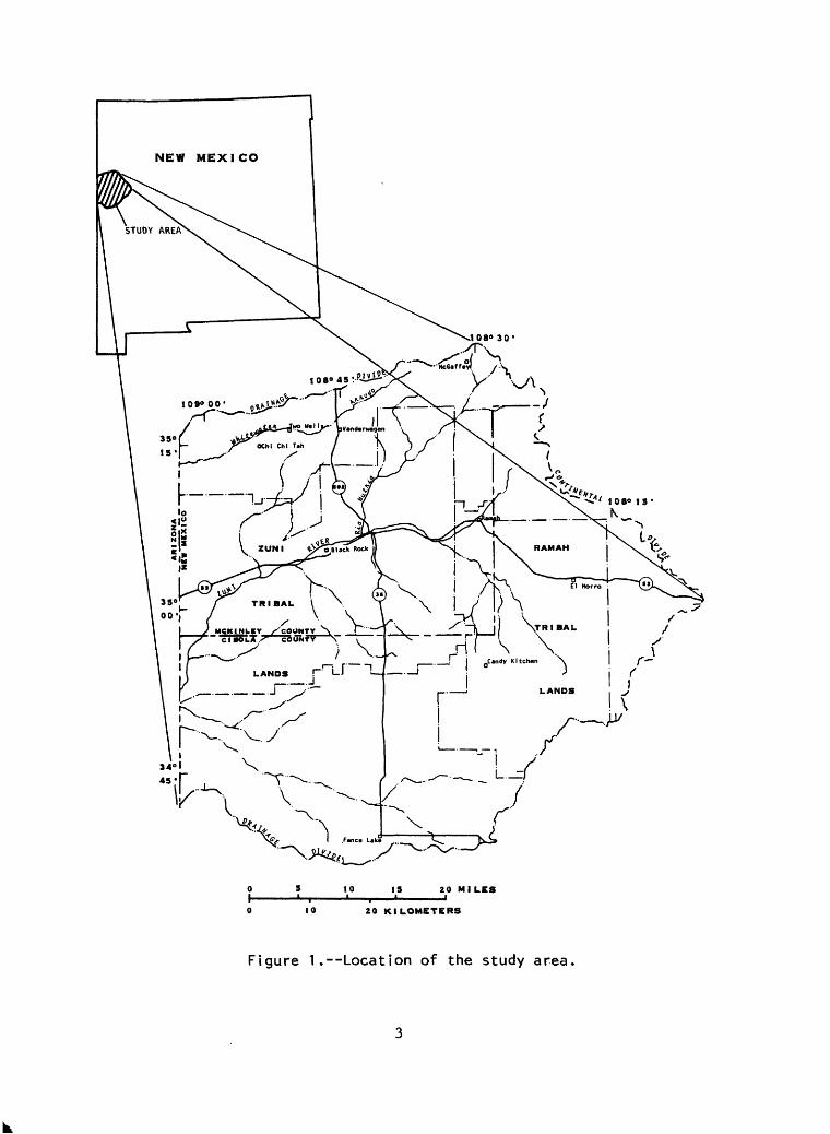
Figure 1. Map showing location of the study area........................ 3
TABLES
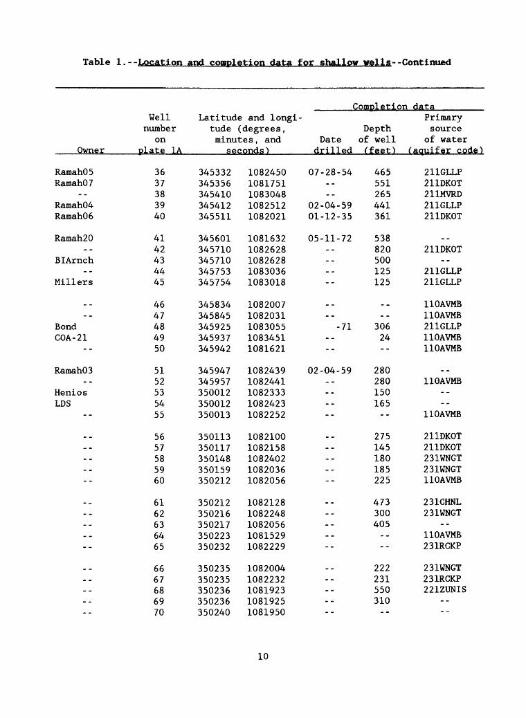
Table 1. Location and completion data for shallow wells
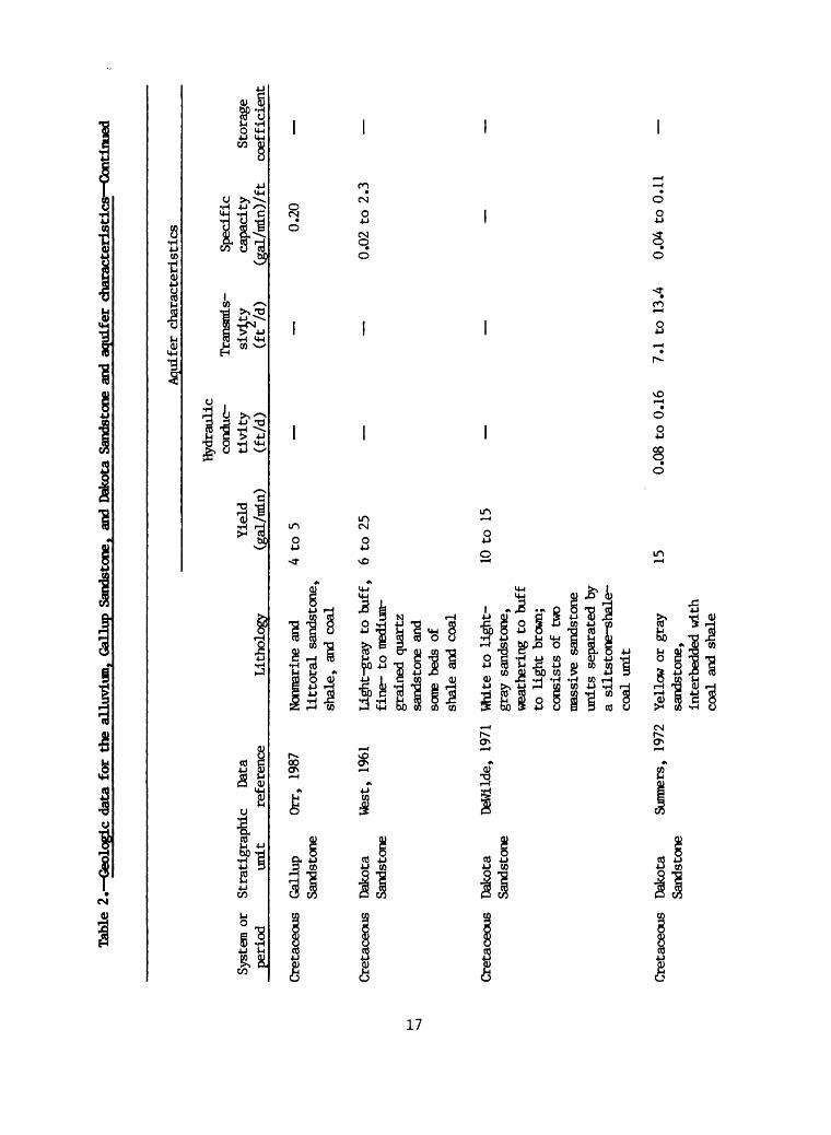
2. Geologic data for the alluvium, Gallup Sandstone, and DakotaSandstone and aquifer characteristics........................ 15
3. Water-chemistry data for shallow wells ......................... 19
111
CONVERSION FACTORS
For the convenience of readers who may want to use International System of Units (SI), the data may be converted by using the following factors.
Multiply inch-pound units By
foot 0.3048mile 1.609 acre-foot 1,233gallon per minute 3.785gallon per minute per foot 12.418ton per acre-foot 0.0007357foot per day 0.3048foot squared per day 0.09290
To obtain SI units
meterkilometercubic meterliter per minuteliter per minute per metermegagram per cubic metermeter per daymeter squared per day
Temperature in degrees Celsius ( °C) can be converted to degrees Fahrenheit (°F) by the equation:
'F = 9/5 (°C) + 32
Sea level: In this report "sea level" refers to the National Geodetic Vertical Datum of 1929 (NGVD of 1929)--a geodetic datum derived from a general adjustment of the first-order level nets of both the United States and Canada, formerly called "Sea Level Datum of 1929."
IV
AQUIFER-CHARACTERISTIC AND WATER-CHEMISTRY DATA FROM WELLS ON
OR NEAR NAVAJO TRIBAL LANDS IN THE ZUNI RIVER BASIN AND
WHITEWATER ARROYO DRAINAGE, WEST-CENTRAL NEW MEXICO
By Carole L. Goetz
ABSTRACT
Three stratigraphic units: the alluvium, the Gallup Sandstone, and the Dakota Sandstone have favorable water-bearing characteristics and are present throughout most of the Navajo tribal lands in the Zuni River basin and Whitewater Arroyo drainage, west-central New Mexico. Reported well yields are: less than 10 to 500 gallons per minute for the alluvial ..aquifer; 4 to 260 gallons per minute for the Gallup Sandstone; and 1 to 300 gallons per minute for the Dakota Sandstone.
Baseline diagrams of water-chemistry data for seven wells completed in the alluvium show that hardness exceeded the U.S. Environmental Protection Agency recommended drinking-water standard in water from one well, and concentrations of iron and manganese exceeded the standard in water from another well. For 12 wells completed in the Gallup Sandstone, concentrations of dissolved solids, hardness, sodium, sulfate, iron, and manganese exceeded the recommended standard in water from one to five wells. For 10 wells completed in the Dakota Sandstone, concentrations of dissolved solids, hardness, sodium, sulfate, iron, and manganese exceeded the recommended standard in water from two to six wells. Concentrations of dissolved solids and boron did not exceed the recommended standard for livestock-water supply in water from any well. Specific conductance and sodium-adsorption ratio exceeded the recommended standard for irrigation-water supply in water from three to eight wells in the Gallup and Dakota Sandstone; however, in the alluvium, the sodium-adsorption ratio exceeded the recommended standard in water from one well and boron exceeded the recommended standard in water from another well.

INTRODUCTION
The U.S. Bureau of Indian Affairs requires compilation of aquifer- characteristic and water-chemistry data, for "shallow" wells (completed no deeper than about 1,500 feet below land surface), on or near Navajo tribal lands in the Zuni River basin and Whitewater Arroyo drainage in west-central New Mexico (fig. 1). The U.S. Bureau of Indian Affairs may use the data to indicate the suitability of water for domestic, irrigation, livestock, municipal, or industrial use; or for legal determinations concerning the impacts of water-resource development in this part of the Navajo Nation. The U.S. Geological Survey and the U.S. Bureau of Indian Affairs entered into a cooperative hydrologic study to describe aquifer characteristics and water chemistry within the area of interest.
Purpose and Scope
The purpose of this report is to provide aquifer-characteristic and water-chemistry data from shallow wells for Navajo tribal lands in the Zuni River basin and Whitewater Arroyo drainage, west-central New Mexico. The report includes aquifer-characteristic data for the alluvium, Gallup Sandstone, and Dakota Sandstone compiled from previous studies of the area. Also included are water-chemistry data (1933-88) for shallow wells in the study area from the U.S. Geological Survey's computerized National Water Information System (NWIS) data base, the Navajo Nation Division of Natural Resources, and the Indian Health Service at Black Rock, New Mexico (fig. 1). The U.S. Environmental Protection Agency computerized data-storage system does not contain any information that was not in the other files. Water-chemistry data collected by U.S. Geological Survey personnel in 1987-88 for 21 selected wells that withdraw water from the alluvium, Gallup Sandstone, or Dakota Sandstone served to expand the data base and provide up-to-date water- chemistry information.
U.S. Geological Survey personnel searched the files of the New Mexico State Engineer Office, the Navajo Nation Division of Natural Resources, and the U.S. Geological Survey in order to compile a list of wells generally less than 1,500 feet deep (table 1). Some wells are included that were outside but near Navajo tribal lands to provide continuity of data. The distribution of wells is shown on plate 1A.
Description of the Study Area
The study area, in west-central New Mexico (fig. 1), consists of the Navajo tribal lands in the Zuni River basin and Whitewater Arroyo drainage west of the Continental Divide. The Navajo tribal lands north of the Zuni tribal lands are often described as "checkerboard" lands because land ownership is split up by section; land in about every other section is Indian- owned, which creates a checkerboard pattern on an ownership map. Navajo tribal lands east of Zuni lands belong to the Ramah Navajo tribe. Because aquifers are continuous across political borders, data were collected and are presented from nearby lands that were not under Navajo.ownership.
v-\
10 IS 20 Ml LES
10 20 KILOMETERS
Figure 1. Location of the study area.

AQUIFER CHARACTERISTICS
The most dependable and readily available supply of water in the study area is ground water. Wells within the study area are generally located near populated areas and scattered ranches.
Shallow stratigraphic units that provide most of the ground-water supply are: alluvium, basalt flows, Gallup Sandstone, Mancos Shale, Dakota Sandstone, Zuni Sandstone, Wingate Sandstone, Chinle Formation, San Andres Limestone, and Glorieta Sandstone (Orr, 1987). A discussion of these units can be found in Orr (1987).
Three stratigraphic units of interest to the U.S. Bureau of Indian Affairs, which are present throughout most of the area and have favorable water-bearing characteristics (DeWilde, 1971; Orr, 1987), are the alluvium, Gallup Sandstone, and Dakota Sandstone. For these units, table 2 presents a range of well yields and aquifer characteristics reported in previous studies. Reported well yields for the alluvium range from less than 10 (Orr, 1987) to 125 gallons per minute (Summers, 1972). Alluvial wells located in buried channel deposits have yielded as much as 200 to 500 gallons per minute (Orr, 1987). A yield of 200 gallons per minute for a short duration (no more than 20 days) was reported (Salt River Project, 1983) for the Salt River Project located near Fence Lake (fig. 1). Reported well yields for the Gallup Sandstone range from 4 to 5 gallons per minute (Orr, 1987) to 11 to 260 gallons per minute (West, 1961). Reported well yields for the Dakota Sandstone range from 1 to 32 gallons per minute (Orr, 1987) to about 300 gallons per minute (Salt River Project, 1983). Values of transmissivity reported are 2 feet squared per day (Summers, 1972) for the Gallup Sandstone, and range from 1 to 7 feet squared per day (Orr, 1987) to 709 feet squared per day (Salt River Project, 1983) for the Dakota Sandstone. Storage coefficient reported in table 2 for the alluvium is 6.1 x 10 ~5 to 3.1 x 10' 4 (Salt River Project, 1983).

WATER-CHEMISTRY CHARACTERISTICS
The chemical composition of natural water determines its suitability for use. The primary uses of water in the study area are for publ ic-drinking, livestock, and irrigation supply.
A baseline diagram is a visual representation of selected constituents of a water-chemistry analysis (Dulas, 1978). It quickly shows whether constituents of an analysis fall above or below referenced guidelines. It also shows how much each constituent is above or below the guideline. In this report baseline diagrams indicate the suitability of water for public- drinking, livestock, and irrigation supply for wells in the alluvium (pi. IB), the Gallup Sandstone (pi. 1C), and the Dakota Sandstone (pi. ID). Baseline diagrams are presented for every well within the three stratigraphic units that included an analysis for the constituents of interest. The baseline (horizontal line) represents the maximum acceptable level (100 percent) of chemical-constituent concentrations in public-drinking water set by the U.S. Environmental Protection Agency (1986); in livestock-drinking water recommended by the National Academy of Sciences-National Academy of Engineering (1972); and in irrigation water recommended by the U.S. Salinity Laboratory Staff (1954) and Hem (1985). Lines extending vertically from the baseline represent the percentage of deviation from the baseline. Lines below the baseline indicate percent of deviation below the referenced standard, whereas lines above the baseline indicate percent of deviation above the referenced standard.
The baseline diagrams are based on a small number of selected chemical constituents and properties. More than 150 inorganic and organic chemical constituents currently have U.S. Environmental Protection Agency recommended public drinking-water standards, and new standards are being developed for additional chemical constituents. The baseline diagrams show seven inorganic chemical constituents and one property to indicate suitability of water as a public-drinking supply; two inorganic constituents to indicate suitability of water as a livestock supply; and two constituents and one property to indicate suitability of water as an irrigation supply. For all samples analyzed, concentrations of arsenic, barium, cadmium, chromium, lead, mercury, selenium, and silver were less than the U.S. Environmental Protection Agency (1986) maximum contaminant levels.
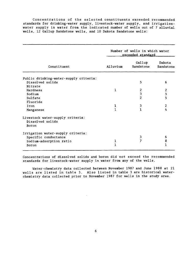
Concentrations of the selected constituents exceeded recommended standards for drinking-water supply, livestock-water supply, and irrigation- water supply in water from the indicated number of wells out of 7 alluvial wells, 12 Gallup Sandstone wells, and 10 Dakota Sandstone wells:
Number of wells in which water _____exceeded standard______
Gallup Dakota Constituent Alluvium Sandstone Sandstone
Public drinking-water-supply criteria:Dissolved solids 5 6NitrateHardness 122Sodium 3 5Sulfate 2 5FluorideIron 132Manganese 114
Livestock water-supply criteria: Dissolved solids Boron
Irrigation water-supply criteria:Specific conductance 3 6 Sodium-adsorption ratio 178 Boron 1 1
Concentrations of dissolved solids and boron did not exceed the recommended standards for livestock-water supply in water from any of the wells.
Water-chemistry data collected between November 1987 and June 1988 at 21 wells are listed in table 3. Also listed in table 3 are historical water- chemistry data collected prior to November 1987 for wells in the study area.

SELECTED REFERENCES
Bliss, J.D., 1982, Surface- and ground-water references index for the Navajo Indian Reservation, Arizona, New Mexico, and Utah: U.S. Geological Survey Open-File Report 82-413, 17 p.
DeWilde, E.G., Jr., 1971, Report on water availability for the Ramah Navajo Indian Reservation: U.S. Bureau of Indian Affairs, Albuquerque, New Mexico, 23 p.
Dulas, Rick, 1978, The baseline diagram--A new water quality diagram, in Waldron, G.A., compiler, Short papers on research in 1977: Kansas Geological Survey Bulletin 211, pt. 4, p. 10-16.
Hem, J.D., 1985, Study and interpretation of the chemical characteristics of natural water (third ed.): U.S. Geological Survey Water-Supply Paper 2254, 263 p.
National Academy of Sciences-National Academy of Engineering, 1972, Water quality criteria, 1972: Washington, D.C., National Academy of Sciences, 594 p.
Orr, B.R., 1987, Water resources of the Zuni tribal lands, McKinley and Cibola Counties, New Mexico: U.S. Geological Survey Water-Supply Paper 2227, 76 p.
Salt River Project, 1983, Fence Lake coal leasehold water-well drilling and testing: Water Resource Operations, Groundwater Planning Division, Phoenix, Arizona, 61 p.
Summers, W.K. , 1972, Hydrogeology and water supply of the Pueblo of Zuni, McKinley and Valencia Counties, New Mexico: New Mexico Bureau of Mines and Mineral Resources open-file report, 119 p.
U.S. Environmental Protection Agency, 1986, Maximum contaminant levels (subpart B of part 141, National interim primary drinking-water regulations): U.S. Code of Federal Regulations, Title 40, Parts 100 to 149, revised as of July 1, 1986, p. 524-528.
U.S. Salinity Laboratory Staff, 1954, Diagnosis and improvement of saline and alkaline soils: United States Department of Agriculture Handbook 60, 160 p.
West, S.W., 1961, Availability of ground water in the Gallup area, New Mexico: U.S. Geological Survey Circular 443, 21 p.
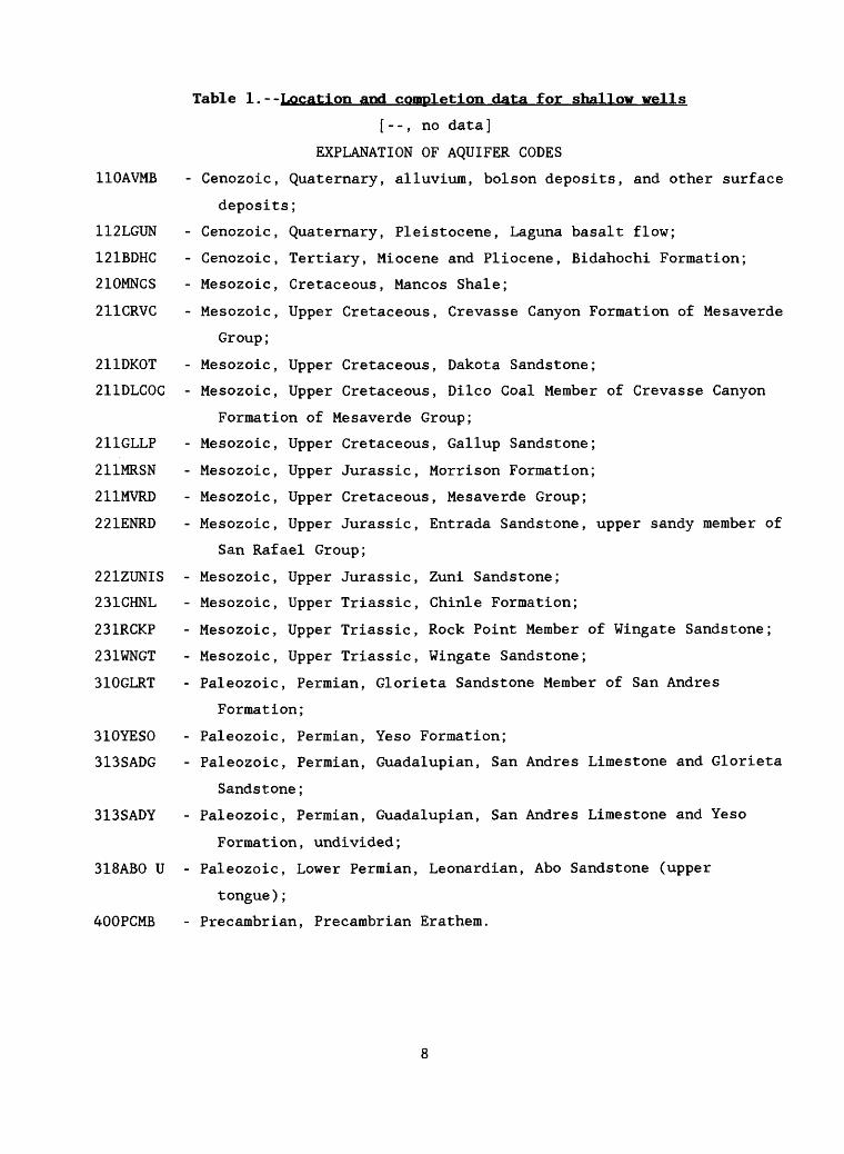
Table 1.--Location and completion data for shallow wells
[- -, no data]
EXPLANATION OF AQUIFER CODES
110AVMB - Cenozoic, Quaternary, alluvium, bolson deposits, and other surface
deposits;
112LGUN - Cenozoic, Quaternary, Pleistocene, Laguna basalt flow;
121BDHC - Cenozoic, Tertiary, Miocene and Pliocene, Bidahochi Formation;
210MNCS - Mesozoic, Cretaceous, Mancos Shale;
211CRVC - Mesozoic, Upper Cretaceous, Crevasse Canyon Formation of Mesaverde
Group;
211DKOT - Mesozoic, Upper Cretaceous, Dakota Sandstone;
211DLCOC - Mesozoic, Upper Cretaceous, Dilco Coal Member of Crevasse Canyon
Formation of Mesaverde Group;
211GLLP - Mesozoic, Upper Cretaceous, Gallup Sandstone;
211MRSN - Mesozoic, Upper Jurassic, Morrison Formation;
211MVRD - Mesozoic, Upper Cretaceous, Mesaverde Group;
221ENRD - Mesozoic, Upper Jurassic, Entrada Sandstone, upper sandy member of
San Rafael Group;
221ZUNIS - Mesozoic, Upper Jurassic, Zuni Sandstone;
231CHNL - Mesozoic, Upper Triassic, Chinle Formation;
231RCKP - Mesozoic, Upper Triassic, Rock Point Member of Wingate Sandstone;
231WNGT - Mesozoic, Upper Triassic, Wingate Sandstone;
310GLRT - Paleozoic, Permian, Glorieta Sandstone Member of San Andres
Formation;
310YESO - Paleozoic, Permian, Yeso Formation;
313SADG - Paleozoic, Permian, Guadalupian, San Andres Limestone and Glorieta
Sandstone;
313SADY - Paleozoic, Permian, Guadalupian, San Andres Limestone and Yeso
Formation, undivided;
318ABO U - Paleozoic, Lower Permian, Leonardian, Abo Sandstone (upper
tongue);
400PCMB - Precambrian, Precambrian Erathem.
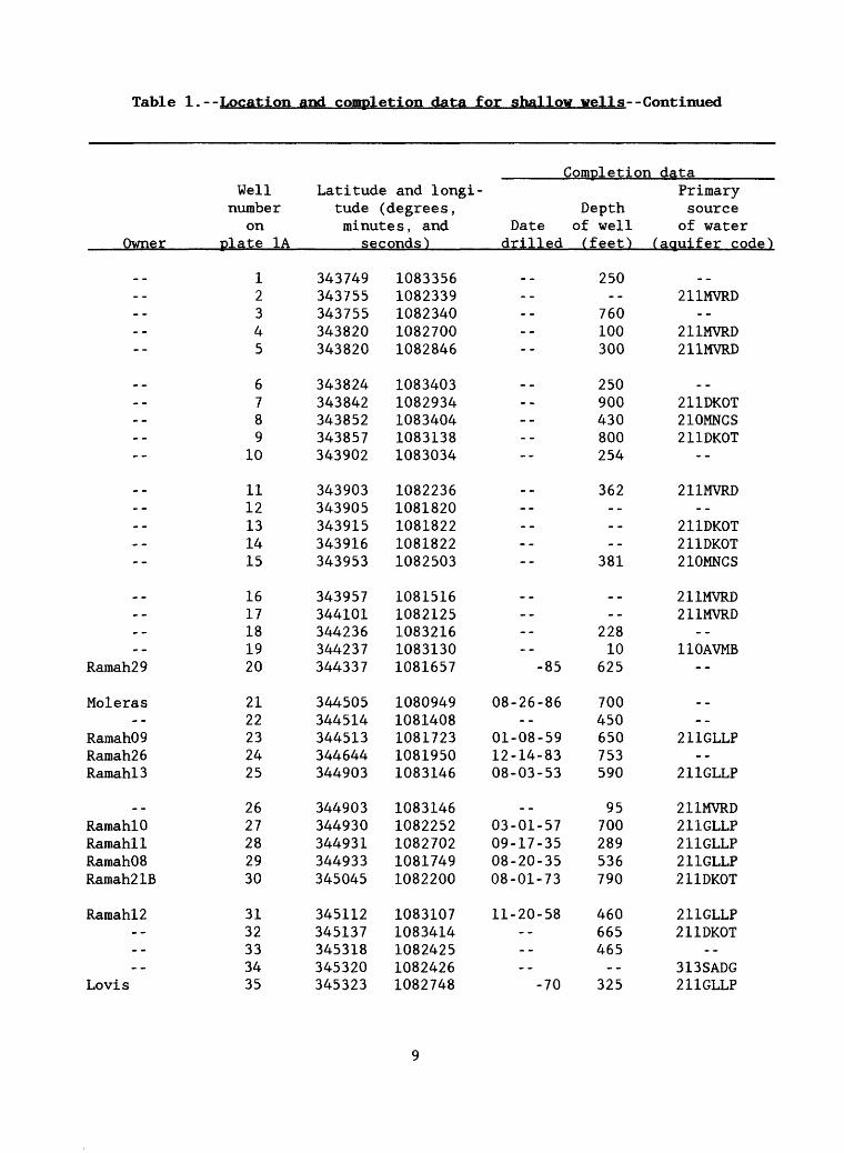
Table 1. - -Location and completion data for shallow wells--Continued
Completion data
Owner
--
..
--
--
>.Ramah29
Moleras
Ramah09Ramah26RamahlS
RamahlORamahllRamahOSRamah21B
Ramahl2
Lovis
Well Latitude and longi- number tude (degrees, Depth
on minutes, and Date of well plate 1A seconds') drilled (feet)
12345
6789
10
1112131415
1617181920
2122232425
2627282930
3132333435
343749343755343755343820343820
343824343842343852343857343902
343903343905343915343916343953
343957344101344236344237344337
344505344514344513344644344903
344903344930344931344933345045
345112345137345318345320345323
10833561082339108234010827001082846
10834031082934108340410831381083034
10822361081820108182210818221082503
10815161082125108321610831301081657 -85
1080949 08-26-8610814081081723 01-08-591081950 12-14-831083146 08-03-53
10831461082252 03-01-571082702 09-17-351081749 08-20-351082200 08-01-73
1083107 11-20-581083414108242510824261082748 -70
250
760100300
250900430800254
362
381
_ _
22810
625
700450650753590
95700289536790
460665465
325
Primary source
of water (aquifer code)
211MVRD--
211MVRD211MVRD
211DKOT210MNCS211DKOT
--
211MVRD
211DKOT211DKOT210MNCS
211MVRD211MVRD
110AVMB--
211GLLP
211GLLP
211MVRD211GLLP211GLLP211GLLP211DKOT
211GLLP211DKOT
313SADG211GLLP
Tabl e 1. - - Location and completion data for fiKallow veils- - Cont inued
Comoletion data
Owner
RamahOSRamahO?
--Ramah04Ramah06
Ramah20
BIArnch
Millers
_ _--
BondCOA-21
RamahOS
HeniosLDS
--
_ _
--
_ _
--
_
Well number
on plate 1A
3637383940
4142434445
4647484950
5152535455
5657585960
6162636465
6667686970
Latitude and longi tude (degrees, Depth minutes , and Date of well
seconds) drilled (feet)
345332345356345410345412345511
345601345710345710345753345754
345834345845345925345937345942
345947345957350012350012350013
350113350117350148350159350212
350212350216350217350223350232
350235350235350236350236350240
10824501081751108304810825121082021
10816321082628108262810830361083018
10820071082031108305510834511081621
10824391082441108233310824231082252
10821001082158108240210820361082056
10821281082248108205610815291082229
10820041082232108192310819251081950
07-28-54 465551265
02-04-59 44101-12-35 361
05-11-72 538820500125125
_ - - -
-71 30624
--
02-04-59 280280150165
--
275145180185225
473300405
_.--
222231550310
..
Primary source
of water ( aquifer code)
211GLLP211DKOT211MVRD211GLLP211DKOT
211DKOT
211GLLP211GLLP
110AVMB110AVMB211GLLP110AVMB110AVMB
110AVMB----
110AVMB
211DKOT211DKOT231WNGT231WNGT110AVMB
231CHNL231WNGT
--110AVMB231RCKP
231WNGT231RCKP221ZUNIS
----
10

Table 1.--Location and completion data for shallow wells--Continued
ComDletion data
Owner
..--------
_ _
------
Ramah21------
ECW-13
RL&C . CORaraahl9RaraahOl
----
----
ECW-22--
_ _------
--------
Well Latitude and longi- number tude (degrees, Depth
on minutes, and Date of well plate 1A seconds') drilled (feet)
7172737475
7677787980
8182838485
8687888990
9192939495
96979899
100
101102103104105
350242350242350243350243350245
350245350246350246350247350254
350254350308350318350324350328
350405350443350446350522350532
350537350538350543350649350716
350722350722350729350730350748
350758350801350802350808350808
10819141081938108203510821111082019
10821461081950108195810816271082239
10822391081827108325610828581083246
10822191082247108300010826401082618
10822431082618108225710838111082912
10828421082856108285510847131082647
10826231082923108293310829391082955
1,410230165
__136
200196157
__213
10-21-75 480____
193707
-71 35209-02-67 38802-14-57 235
5651,092
_ _ _ __ ___
282--
_ _ _ ___
1,175102
59325772120112
Primary source
of water ( aquifer code")
..--------
221ZUNIS110AVMB231WNGT112LGUN110AVMB
112LGUN211DKOT110AVMB211DKOT
231WNGT110AVMB110AVMB211DKOT221ENRD
110AVMB313SADG110AVMB211GLLP110AVMB
110AVMB211DKOT211DKOT310GLRT110AVMB
110AVMB211DKOT211DKOT
110AVMB
11
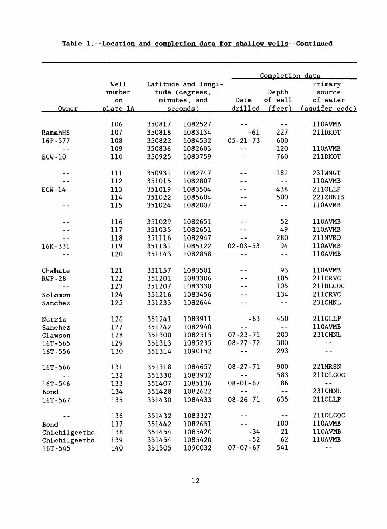
Table 1.--Location and completion data for shallow wells--Continued
Completion data
Owner
RamahHS16P-577
ECW-10
_ _
ECW-14
--
_ _
16K-331--
ChahateRWP-28
SolomonSane he z
NutriaSane he zClawson16T-56516T-556
16T-566
16T-546Bond16T-567
..BondChichilgeethoChichilgeetho16T-545
Well number
on plate 1A
106107108109110
111112113114115
116117118119120
121122123124125
126127128129130
131132133134135
136137138139140
Latitude and longi tude (degrees, Depth minutes, and Date of well
seconds) drilled (feet)
350817350818350822350836350925
350931351015351019351022351024
351029351035351116351131351143
351157351201351207351216351233
351241351242351300351313351314
351318351330351407351428351430
351432351442351454351454351505
10825271083134108453210826031083759
10827471082807108350410856041082807
10826511082651108294710851221082858
10835011083306108333010834561082644
10839111082940108251510852351090152
10846571083932108513610826221084433
10833271082651108542010854201090032
-61 22705-21-73 600
120760
182
438500
--
5249280
02-03-53 94--
93105105134
--
-63 450__
07-23-71 20308-27-72 300
293
08-27-71 900583
08-01-67 86__
08-26-71 635
_ _ _ _100
-34 21-52 62
07-07-67 541
Primary source
of water (aquifer code)
110AVMB211DKOT
110AVMB211DKOT
231WNGT110AVMB211GLLP221ZUNIS110AVMB
110AVMB110AVMB211MVRD110AVMB110AVMB
110AVMB211CRVC211DLCOC211CRVC231CHNL
211GLLP110AVMB231CHNL
--
221MRSN211DLCOC
--231CHNL211GLLP
211DLCOC110AVMB110AVMB110AVMB
--
12

Table 1.--Location and completion data for shallow wells--Continued
Completion data
Owner
16T-574----
JonesJones
16T-557--
NavarreVanderwagen16T-576
16T-56816T-51116T-580
--Grubisich
Grubisich16T-599Grubisich16T-564
NavarreGrubisich16T-615Navarre
16T-570JekielekRadosevichRadosevichRadosevich
16T-543--------
Well Latitude and longi- number tude (degrees, Depth
on minutes, and Date of well plate 1A seconds) drilled (feet)
141142143144145
146147148149150
151152153154155
156157158159160
161162163164165
166167168169170
171172173174175
351532351634351647351653351653
351656351722351734351745351818
351823351825351853351855351906
351906351907351915351916351918
351921351927351930351946352000
352000352012352018352018352018
352022352039352137352149352150
10844371083006108393210859101085910
10900021084521108234810855421085525
10851511084950108482710824401082535
10826441082534108452710825391083641
10827371082718108255910856331082626
10838481082644108290210829021082902
10849501084313108291310828351082834
08-02-73 749
10004- -55 50810- -58 600
02-09-71 56544
-64 250770
__
09-15-71 83210-18-60 50001- -73 497
385
_ _ _ ___
09-01-79 1,40085
09-18-71 640
_ _ _ _135150
25
11-09-71 1,14375
11-26-76 262190
07-26-55 80
04-18-67 591_ __ __ _
Primary source
of water (aquifer code)
211GLLP
211GLLP121BDHC
--
310YESO----
211DKOT211GLLP211GLLP
--318ABO U
110AVMB110AVMB211GLLP110AVMB211CRVC
110AVMB318ABO U318ABO U
110AVMB
211GLLP110AVMB400PCMB
--110AVMB
_ _
110AVMB110AVMB
13

Table 1.--Location and completion data for shallow wells--Concluded
Comelet:ion dataWell Latitude and longi- Primary
number tude (degrees, Depth sourceon minutes, and Date of well of water
Owner____plate 1A______seconds )______drilled (feet) (aquifer code)
176 352233 1083042 -- -- 313SADY177 352251 1082841 -- -- 310YESO178 352302 1082933
14

[gal
/min
, ga
llon
s pe
r mi
nute
; ft
/d,
feet
per day
; ft
/d»
fee
t squared
per
day;
(galAun)/f t,
gal
lons
per min
ute pe
r foot o
f drawdown.
» no data}
Syst
em or
Stra
tigr
aphi
c Da
ta
peri
od
Wilt
reference
LitholoBV
Quaternary Alluvium
Quat
erna
ry Al
luvi
um
Quaternary Al
luvi
um
Quat
erna
ry Al
luvi
um
DeWilde, 1
971
Fine
to coarse
grai
ned
sand,
silt,
and
gravel
Simm
ers,
1972
Sand
, gr
avel
, si
lt,
and clay
Salt
Riv
er
Unconsolidated
Proj
ect,
1983 valley fil
l
Orr, 19
87
Sand
, gr
avel
, si
lt,
and cl
ay de
posi
ted
alon
g su
rfac
e
^q^fef cha
ract
eris
tics
Hydraulic
conduc-
Tran
smis
- Specific
Yiel
d tivity
sivi
ty
capacity
Storage
(gal/mir^)
(ft/d)
(ft
/d)
(gal^irJTO/ft
coefficient
25 or
less
125
8.4
353
1.2
200 fo
r pe
r-
1,13
9 to 1
,293
5.7
6.1 x 10^ t
o io
ds o
f no
3.1 x
10
more
than
20 days
Gene
rall
y less
than 1
0
Buri
edchannel
deposits
drainages
Channel
depo
sits
of
sand
, gr
avel
, si
lt,
and clay und
erly
ing
basalt
200
to 5
00

Ta
ble
2,
for H
»a<
'D
afco
tv*
t'ni
M>
Syst
em or
peri
odStratigraphic
Data
unit
reference
Yiel
d Li
thol
ogy
( gal
fvn n
)
Hydr
auli
cconduc
tivity
(ft/
d)
Tran
smis
-sivity
(ft/d)
Specific
capa
city
(8
al/^
in)/
ftSt
orag
e coefficient
Cret
aceo
us Ga
llup
Sand
ston
e
Cretaceous
Gallup
Sand
ston
e
Cret
aceo
usGallup
Sandstone
West
, 1961
Ligh
t-gr
ay, bu
ff,
11 t
o 260
and
pale-red, very
fine
to very
coarse g
rained
sandstone, a
nd
thin
to
thic
k be
ds o
f sh
ale
DeWi
lde,
1971 Yellowish-tan
Less t
han
10
sand
ston
e,
interbedded wi
th
dark
-gra
y sh
ale an
d coal
Summ
ers,
1972
Sa
ndst
one an
d sh
ale
10
with bed
s of
coa
l;
sandstone ranges
from cle
ar,
ligh
t-
colored, med
ium-
gr
aine
d cl
iff
form
ers
to fin
e
grai
ned,
dar
k-gr
ay,
carb
onac
eous
, si
lty
sandstone
0.08
to 4.7
0.13
2.0
0.04
Tabl
e 2, Geologic data for
the
alluvium, G
allu
p Sa
ndst
one,
and Dak
ota Sa
ndst
one an
d aquifer characteristics Continued
Aqui
fer
characteristics
Syst
em or
peri
odSt
rati
grap
hic
Data
unit
refe
renc
eYield
Lithology
(gal/min)
Hydr
auli
cconduc
tivity
(ft/d)
Tran
smis
-sivity
(ft:
/d)
Specific
capa
city
(gal/tnLn)/ft
Stor
age
coef
fici
ent
Cret
aceo
us
Gall
up
Orr, 1987
Sand
ston
e
Cret
aceo
us Da
kota
We
st,
1961
Sa
ndst
one
Cret
aceo
usDakota
Sand
ston
eDe
Wild
e, 1971
Cretaceous
Dako
ta
Sand
ston
eSu
mmer
s, 19
72
Nonmarine an
d 4
to 5
littoral s
andstone,
shale, a
nd c
oal
Ligh
t-gr
ay t
o bu
ff,
6 to
25
fine
- to med
ium-
grained qu
artz
sandstone an
d so
me b
eds
of
shal
e an
d coal
Whit
e to light-
10 t
o 15
gray
sandstone,
weat
heri
ng t
o bu
ffto
lig
ht brown;
cons
ists
of
two
massive
sandstone
unit
s separated by
a si
ltst
one-
shal
e-coal uni
t
Yellow or gray
15
sand
ston
e,
inte
rbed
ded wi
th
coal
and
sha
le
0.20
0.02 t
o 2.3
0.08
to 0.
16
7.1
to 1
3.4
0.04 t
o 0.11

Tabl
e 2.
Geo
logi
c da
ta for
the
alluvium, G
allu
p Sandstone, a
nd Dakota Sandstone an
d aq
uife
r ch
arac
teri
stic
s Co
nclu
ded
Aqui
fer
characteristics
System or
Stratigraphic
Data
period
unit
re
fere
nce
Yiel
d Lithology
(gal
/rai
n)
Hydr
auli
c conduc
tivity
(ft/d)
Tran
sroi
s-
sivity
(ft/
d)
Spec
ific
ca
paci
ty
(gal
/min
)/ft
Stor
age
coef
fici
ent
Cretaceous Da
kota
Sa
lt Riv
erSandstone
Project, 19
83
Cret
aceo
us Da
kota
Qr
r, 1
987
Sandstone
Inte
rtid
al t
o fl
uvia
l sandstone,
shal
e, a
nd coal
Abou
t 30
0
1 to 3
20.
07
709
1 to 7
0.85
0.07
oo

Table 3.-- Water-cheipis try data for shallow wells
[deg. C, degrees Celsius; gal/min, gallons per minute; acre-ft, acre-feet;
mg/L, milligrams per liter; --, no data; uS/cm, microsiemens per centimeter at
25 degrees Celsius; ug/L, micrograms per liter; pCi/L, picocuries per liter;
E, estimated; noncarb wh wat tot fid, noncarbonate whole water total field;
wat wh tot fet, water whole total fixed end-point titration; wat dis tot fet,
water dissolved total fixed end-point titration; fet-fld, fixed end-point
titration-field; wat dis tot it, water dissolved total incremental titration;
M, presence of material verified but not quantified; dis it, dissolved
incremental titration; wat dis incr t, water dissolved incremental titration;
wh fet, whole fixed end-point titration; <, less than. See table 1 for
explanation of aquifer codes. The five-digit codes shown in parentheses
in the column headings are parameter codes that uniquely identify a
specific constituent. These standard codes, used to identify the data
stored in the files of National Water Information System, are identical
to those used in the U.S. Environmental Protection Agency data system STORET.
The U.S. Environmental Protection Agency assigns and approves all requests for
new codes. Data from the U.S. Geological Survey, the Navajo Nation Division
of Natural Resources, and the Indian Health Service in Black Rock, N. Hex.]
19

Table 3.--Water-chemistrv data for shallow wells--Continued
Wellnumber
onplate 1A
7
19
25
26
28
29
31
32
33
3436
38
40
42
44
45
51
60
67
76
80
82
83
Latitude-longitude
identificationnumbpr
343842108293401
344237108313001
344903108314601
344903108314602
344931108270201
344933108174901
345112108310701
345137108341401
345318108242501
345320108242601345332108245001
345410108304801
345511108202101
345710108262801
345753108303601
345754108301801
345947108243901
350212108205601
350235108223201
350245108214601
350254108223901
350308108182701
350318108325601
Aquifercode
211DKOT
1 1 OAVMB
211CLLP
21 IMVKD
211CLLP
211CU.P
211GLLP
211DKOT
..--
313SADG211GLLP
2J1MVRD
211DKOT
21 IDKIlT
211GM.P
211GLL11
._
11 OAVMB
231RCKP
221ZUNTS
11 OAVMB
1 12LCMIH
211DKOT
Date
06-13-88
11-21-80
07-02-5307-17-5307-29-5303-29-88
07-29-53
11-17-87
03-29-88
11-17-87
01-06-81
07-28-5407-28-5405-14-7511-17-87
01-08-81
07-14-6911-17-87
Ofi-16-88
07-28-72
05-19-88
07-14-6910-25-7212-04-7309-21-7802-28-8101-15-87
09-02-62
04-25-59
02- -6001-05-81
09-21-78
01-05-81
07-31-72
Time
1330
1015
-_----
1615
--
1230
1400
1415
1150
12001230--
0950
0920
--1600
1515
--
1630
1200------
1300--
--
-
..1500
--
1410
--
Flowrate.
instantaneous
(gal/min)(00059)
--
2.0
.-3.57.9--
7.9
--
--
--
4.0
E12E12 --
10
----
-
--
--
------------
...
23
3810
--
5.0
--
Solids, dis
solved(tonsper
acre-f t )(70303)
0.49
0.25
2.20--
2.040.57
-
0.37
0.28
0.58
1.13
--0.340.910.35
0.53
--2.57
0.51
0.72
1.17
--0.510.620.660.630.51
0.37
0.38
0.360.35
0.72
0.37
1.47
Solids, sum of
consti t-uents,dis
solved(mg/L)(7Q301)
351
184
1.620--
1,500430
278
211
427
835
--250676258
390
--1,970
392
566
801
--220354372486377
273
277
266255
409
271
1,120
20
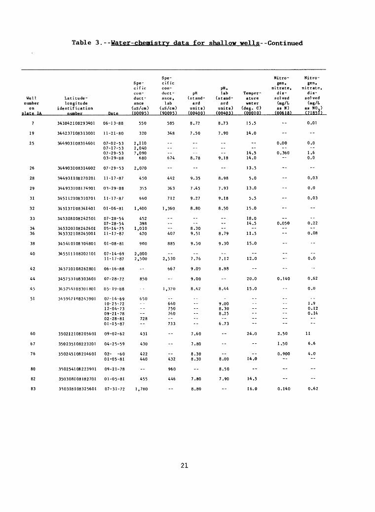
Table 3.--Water-chemistrv data for shallow wells--Continued
Wellnumber
on plate 1A
7
19
25
26
28
29
31
32
33
3436
38
40
42
44
45
51
60
67
76
80
82
83
Latitude-longitude
identification
343842108293401
344237108313001
344903108314601
344903108314602
344931108270201
344933108174901
345112108310701
345137108341401
345318108242501
345320108242601345332108245001
345410108304801
345511108202101
345710108262801
345753108303601
345754 10830 1801
345947108243901
350212108205601
350235108223201
350245108214601
350254108223901
350308108182701
350318108325601
Date
06-13-88
1 1-21-80
07-02-5307-17-5307-29-5303-29-88
07-29-53
11-17-87
03-29-88
11-17-87
01-06-81
07-28-5407-28-5405-14-7511-17-87
01-08-81
07-14-6911-17-87
06-16-88
07-28-72
05- 19-88
07-14-6910-25-7212-04-7309-21-7802-28-8101-15-87
09-02-62
04-25-59
02- -6001-05-81
09-21-78
01-05-81
07-31-72
Spe cificconductance
(uS/cm) (00095)
550
320
2.1102.0407.090
680
2,070
450
355
660
1.400
452398
1.010420
900
2,0002,500
--
850
650..._.---728--
431
430
422440
--
455
1.780
Spe cific conductance ,lab
(uS/cm) (90095)
585
348
------674
--
442
363
712
1,360
__----407
885
-.2.530
667
-
i,:»?o
_.640750740--733
--
--
__432
960
446
--
pH(stand
ardunits)
(00400)
8.72
7.50
----...
8.78
--
9.35
7.45
9.27
8.80
_---
8.309.51
9.50
--7.76
9.09
9.00
8.62
----------
7.60
7.80
8.308.30
--
7.80
8.80
pH.lab
(standard
units) (00403)
8.73
7.90
-_----
9.18
-
8.98
7.93
9.18
8.50
__ --
8.79
9.30
--7.12
8.98
--
8.44
_9.QO8.308.25--
6.73
--
--
__8.00
8.50
7.90
--
Temperaturewater
(deg. C) (00010)
15.5
14.0
----
14.514.0
13.5
5.0
13.0
5.5
15.0
18.014.5
--11.5
15.0
--12.0
--
20.0
15.0
_-----------
24.0
--
__14.0
--
14.5
16.0
Nitro gen,
nitrate.dis
solved(mg/Las N)
(00618)
--
-
0.00--
0.360--
--
--
--
--
--
0.050
----
--
----
--
0.140
--
_-----------
2.50
1.50
0.900--
--
-
0.140
Nitro
gen, nitrate.
dis-sol ved
(mg/Las NO ) (71851)
0.01
--
0.0--
1.60.0
--
0.03
0.0
0.03
--
--0.22--
0.08
--
--0.0
--
0.62
0.0
1.90.120.14----
11
6.6
4.0--
--
--
0.62
21
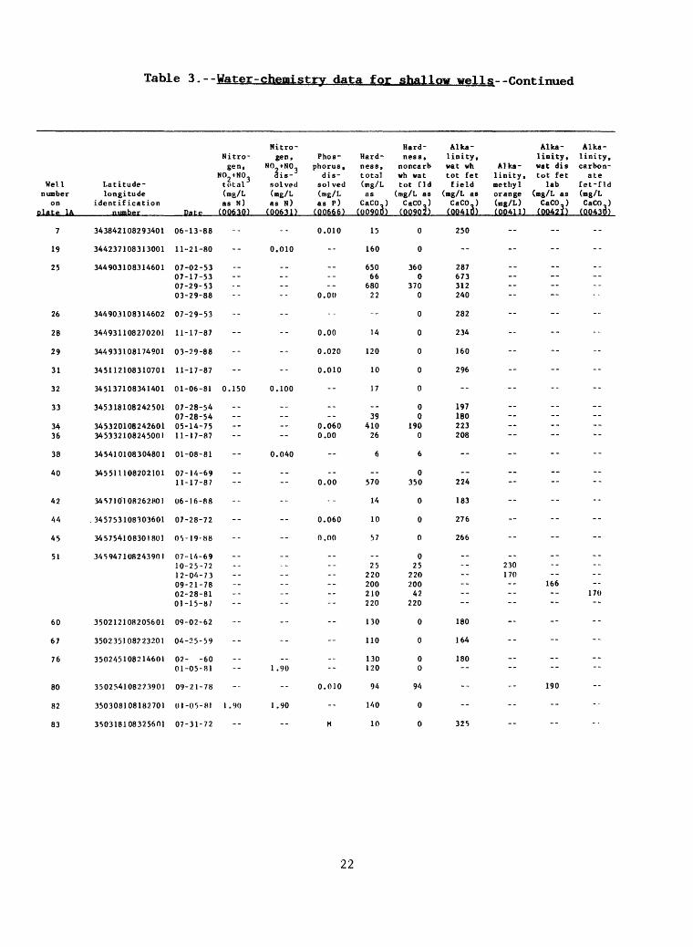
Table 3.--Water-chemistry data for shallow wellg--Continued
Wellnumber
on plate 1A
7
19
25
26
28
29
31
32
33
3436
38
40
42
44
45
51
60
67
76
80
82
83
Latitude-longitude
identification t.
343842108293401
344237108313001
344903108314601
344903108314602
344931108270201
344933108174901
345112108310701
345137108341401
345318108242501
345320108242601345332108245001
345410108304801
345511108202101
34S7IO'! 08262801
. 345753108303601
345754108301801
345947108243901
350212108205601
350235108223201
350245108214601
350254108223901
350308108182701
350318108325601
Nitrogen,
NO +NO.tf.cal(rog/Las N)
Dape (00630)
06-13-88
11-21-80
07-02-5307-17-5307-29-5303-29-88
07-29-53
11-17-87
03-29-88
11-17-87
01-06-81 0.150
07-28-5407-28-5405-14-7511-17-87
01-08-81
07-14-6911-17-87
06-16-88
07-28-72
05-19-88
07-14-6910-25-7212-04-7309-21-7802-28-8101-15-87
09-02-62
04-25-59
02- -6001-05-81
09-21-78
01-05-81 1.90
07-31-72
Hitro-gen, Phos-
NO +NO- phorus.3i»- di s-
solved sol ved(mg/L (mg/Las N) as P)
(00631) (00666)
0.010
0.010
.__-..
0.00
--
0.00
0.020
0.010
0.100
__-_
0.0600.00
0.040
._0.00
..
0.060
0.00
__
__.__.--
--
..
__1.90
0.010
1.90
M
Hardness.total(mg/Las
CaCO-) (00900)
15
160
65066
68022
--
14
120
10
17
--39
41026
6
_-570
14
10
57
--25
220200210220
130
110
130120
94
l/iO
10
Hardness,
noncarbwh vattot fid
(mg/L asCaCO,)
(00902)
0
0
3600
3700
0
0
0
0
0
00
1900
6
0350
0
0
0
025
220200
42220
0
0
00
94
0
0
Alkalinity,vat whtot fetfield
(mg/L asCaCO.)
(00410)
250
--
287673312240
282
234
160
296
--
197180223208
--224
183
276
266
------------
180
164
180--
--
--
325
Alka- Alkalinity, linity.
Alka- vat dis carbon-linity, tot fet atemethyl lab Cet-fldorange (mg/L as (mg/L(mg/L) CaCO-) CaCO ) (00411) (00421) (00430)
..
--
._ ._--
--
--
--
--
--
._------
--
_---
--
--
..
..230170
166170
--
-
--
_.--
190
--
__
22

Table 3.--Water-chemistry data for shallow wells--Continued
Well number
on plate 1A
7
19
25
26
28
29
31
32
33
3436
38
40
42
44
45
51
60
67
76
80
82
83
Latitude- longitude
i.d«nt i fi cot ion number
343842108293401
344237108313001
344903108314601
344903108314602
344931108270201
344933108174901
345112108310701
345137108341401
345318108242501
345320108242601345332108245001
345410108304801
345511108202101
345710108262801
345753108303601
345754108301801
345947108243901
350212108205601
350235108223201
350245108214601
350254108223901
350308108182701
350318108325601
Alka linity, wat distot itfield
(mg/L as CaCO )
Date (39087)
06-13-88
11-21-80
07-02-5307-17-5307-29-5303-29-88
07-29-53
11-17-87
03-29-88
11-17-87 268
01-06-81
07-28-5407-28-5405-14-7511-17-87
01-08-81
07-14-6911-17-87 186
06-16-88
07-28-72
05-19-88
07-14-6910-25-7212-04-7309-21-7802-28-8101-15-87
09-02-62
04-25-59
02- -6001-05-81
09-21-78
01-05-81
07-31-72
Calcium,dis
solved (mg/L AS Ca) (00915)
4.0
30
170-
1806.0
--
3.6
37
3.6
5.0
--11
1104.8
1.9
-_150
4.0
2.0
14
6.056525151
33
31
3630
18
36
0.14
Magne sium,di s-
solved (mg/L As Mg) (00925)
1.2
20
54--
561.7
--
1.2
6.3
0.24
1.?
-_2.8
343.4
0.30
--48
0.97
1.2
5.4
--2.4
19182123
12
7.9
1011
12
12
2.4
Sodium,dis
solved (mg/L ns Na) (00930)
140
8.5
__----
160
--
100
30
160
310
----
6085
710
--400
140
200
270
--14078809283
--
--
_-41
140
43
380
Sodium, pprcent (00932)
95
10
__
--94
--
94
34
97
97
----2486
09
--60
95
97
91
--9243464844
--
--
--42
75
40
98
Sodium-ad-
sorp- tion ratio (00931)
16
0.3
__----
15
--
12
1
23
34
----17
39
--8
17
28
16
--132332
--
--
--2
6
2
52
Sodiumplus
potas sium,dis
solved (mg/L as Na) (00933)
--
--
280
230--
--
--
--
...
--
--82----
-
----
--
--
--
...----
...--
46
55
42--
--
--
Potas
sium,dis
solved (mg/L fl» K) (00935)
1.6
4.1
-_----
1.2
--
0.78
7.0
0.39
1.5
----
4.02.4
0.70
--8.2
0,78
1.0
2.7
--1.22.42.73.14.0
-
2.9
5.1
2.0
5.0
Bicar bonate, water
dis itfield
(mg/L as IICO,) (00453)
277
--
-_
--261
--
215
200
268
--
------
195
_._
--271
192
--
300
------------
--
--
----
-
--
--
23

Table 3.--Water-chemistry data for shallow wells--Continued
Hell number
on p^ate 1A
7
19
25
26
28
29
31
32
33
3436
38
40
42
44
45
51
60
67
76
80
82
83
Latitude- longitude
identificationnumber
343842108293401
344237108313001
344903108314601
344903108314602
344931108270201
344933108174901
345H2108310701
345137108341401
345318108242501
345320108242601345332108245001
345410108304801
345511108202101
345710108262801
345753108303601
3/i5754108301801
34594710824.3901
350212108205601
350235108223201
350245108214601
350254108223901
350308108162701
35031810837.560J
Date
06-13-88
11-21-80
07-02-5307-17-5307-29-5303-29-88
07-29-53
11-17-87
03-29-88
11-17-87
01-06-81
07-28-5407-28-5405-14-7511-17-87
01-08-81
07-14-6911-17-87
06-16-88
07-28-72
07>- 19 88
07-14-6910-25-7212-04-7309-21-7802-28-8101-15-87
09-02-62
04-25-59
02- -60Ol-OS-81
09-21-78
01-05-81
07-31-72
Bicar- Car bonate, bonate,water water
wh fet dis itfield field
(mg/L as (mg/L as HCO, ) CO,) (00450) (OQ452)
15
--
350820380
19
320
32
0
42
--
240220250
36
--
.-
0
17
270
15
...
--.-
210--
220
200
720--
..
. .
340
Car- Car bonate, bonatewat dis waterincr t wh fetlab, as field
CO. (mg/L as (mg/L) CO,) (29809) (00445)
0
--
0930
0
14
0
0
0
--00
1121
--
__0
23
33
0
. .
. ._.-_
0--
0
0
-- - 9
--
--
...
28
Chloride,dissolved (mg/L as Cl) (00940)
12
2.9
104.0105.9
10
4.5
10
5.0
57
8.05.0
193.4
6.6
__15
5.1
8.9
17
_-147.18.9
155.0
16
23
1418
23
13
170
Sulfate,dissolved (mg/L
as SO.) (00945)
40
0.80
920
820110
--
26
24
79
250
--30
30034
160
_-1.200
130
150
330
55190210200210
18
24
1716
210
16
330
Fluo-ride,dis
solved (mg/L as F) (00950)
1.7
2.1
0.100.800.200.88
--
0.32
0.11
1.2
4.4
--
0.500.500.37
1.9
--0.61
0.60
0.90
1.2
--0.640.820.680.630.63
0.20
0.20
0.300.30
0.66
0.30
3.8
Silica,dissolved(mg/L as
SiO,) (00955)
--
13
12--
10--
--
--
--
6.7
--12----
7.7
---
--
--
--
-.----------
29
29
3431
--
26
--
24
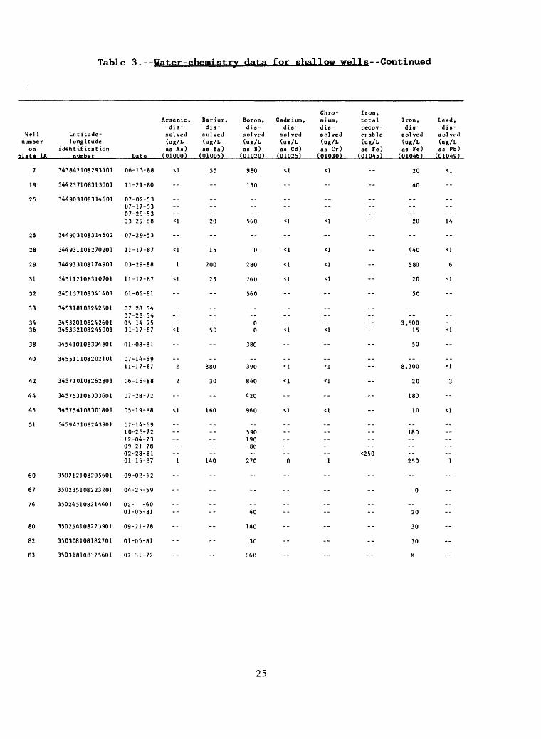
Table 3. - -Water-chemistry data for shallow wells- -Continued
Wellnumber
onplate 1A
7
19
25
26
28
29
31
32
33
3436
38
40
42
44
45
51
60
67
76
80
82
83
Lnt itudo-longitude
identificationnumber
343842108293401
344237108313001
344903108314601
344903108314602
344931108270201
344933108174901
345112108310701
345137108341401
345318108242501
345320108242601345332108245001
345410108304801
345511108202101
345710108262801
345753108303601
345754108301801
345947108243901
350712J08705601
350235108223201
350245108214001
350254108223901
350308108182701
350318108)25001
Arsenic,dis
solved(ug/L as As)
Date (01000)
06-13-88 <1
11-21-80
07-02-5307-17-5307-29-5303-29-88 <1
07-29-53
11-17-87 <1
03-29-88 1
11-17-87 <1
01-06-81
07-28-5407-28-5405-14-7511-17-87 <1
01-08-81
07-14-69
11-17-87 2
06-16-88 2
07-28-72
05-19-88 <1
07-14-6910-25-7212-04-7309 21-7802-28-8101-15-87 1
09-02-62
04-23-59
02- -6001-05-81
09-21-78
01-05-81
07-31-72
Ba r i um ,dis-
sol vcd(ug/L as Ba)
(01005)
55
__----20
--
15
200
25
--
__----50
--
__
880
30
--
160
----
--140
--
..
__--
--
--
Chro-Boron, Cadmium, mium,dis- dis- d i s -
Bolveil solved solved(ug/L (ug/L (ug/L as B) as Cd ) as Cr)
(01020) (01025) (01030)
980 <1 <1
130
_--._.
560 <1 <1
--
0 <1 <1
280 <1 <1
200 <1 <1
560
-.._
00 <1 <1
380
_-
390 <1 <1
840 <1 <1
420
960 <1 <1
-.
590190
80--
270 0 1
--
..
40
140
30
060
Iron,total Iron, Lead,recov- dis- dis*PI able salved aolvol(ug/L (ug/L (ug/L as Fe) as Fe) as Pb)
(01045) (01046) (01049)
20 <1
40
___...
20 14
--
440 <1
580 6
20 <1
50
____
3,50015 <1
50
__8,300 <1
20 3
180
10 <1
_.180
__
<250250 1
--
0
__
20
30
30
M
25
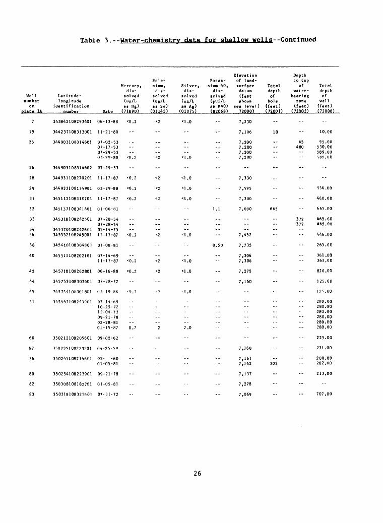
Table 3.--Water-chemistry data for shallow wells--Continued
Wellnumber
onplate 1A
7
19
25
26
28
29
31
32
33
3436
38
40
42
44
45
51
60
67
76
80
82
83
Latitude-longi tude
identificationnumber
343842108293401
344237108313001
344903108314601
344903108314602
344931108270201
344933108174901
345112108310701
345137108341401
345318108242501
345320108242601345332108245001
345410108304801
345511108202101
345710108262801
345753108303601
345754108301801
345947108243901
350212108205601
15023S10877120I
350245108214601
350254108223901
350308108182701
350318108325601
Sele-Morcury, nium.
el i u - dissolved solved(nj>/L (ug/Las llg) as Se)
Date (71890) (OU45)
06-13-88 <0.2 <2
11-21-80
07-02-5307-17-5307-29-53OV?'»-88 *:d.? '2
07-29-53
11-17-87 '0.2 <2
03-29-88 <0.2 '2
11-17-87 <0.2 <2
01-06-81
07-28-5407-28-5405-14-75
11-17-87 <0.2 <2
01-08-81
07-14-6911-17-87 <0.2 <2
06-16-88 <0.2 <2
07-28-72
()'')- 19-88 '().? <:>.
07-1 'i-6910-25-7212^04-7309-21-7802-28-8101-15-87 0.? 2
09-02-62
04-7'i- 5«>
02- -6001-05-81
09-21-78
01-05-81
07-31-72
ElevationPotas- of land-
Silver, siun 40, surface Totaldin- din- datum depth
solved solved (feet of(uR/L (pCj/L above holeas Ag) as K40) sea level) (feet)
(01075) (92068) 7200p) (7UPD
<I.O -- 7,330
7,196 10
7,2007,2007,200
<!.() - 7,200
--
<1.0 -- 7,330
<1.0 -- 7,595
<1.0 -- 7.300
1.1 7.090 665
-_...--
'1.0 -- 7,452
0.50 7,235
7,306<1.0 -- 7,306
<1.0 7,275
7.160
1 ,0
.
._...2.0
--
7,160
7,1617,162 202
7,137
7,278
7,069
Depthto top
ofwater
bearingzone
(feet)(72002)
--
--
65480----
--
--
--
--
372372----
--
----
--
--
--
--
------
--
--
----
--
--
Totaldepthof
well(feet)(72008)
--
10.00
95.00530.00589.00p>89.00
--
--
536.00
460.00
665.00
465.00465.00
--446.00
265.00
361.00361,00
820,00
125,00
l? ri.OO
280,00280,00280.00280,00280.00280.00
225.00
231 .00
200.00202,00
213,00
--
707,00
26

Table 3.--Water-chemistrv data for shallow wells--Continued
Well number
on plate 1A
85
87
89
92
94
99
104
105
107
109
110
114
119
132
133
135
137
140
141
143
146
147
151
153
167
169
171
Latitude- longitude
identification nIBhf"T
350328108324601
350443108224701
350522108264001
350538108261801
350649108381101
350730108471301
350808108293901
350808108295501
350818108313401
350836108260301
350925108375901
351022108560401
351131108512201
351330108393201
351407108513601
351430108/i/i3301
351442108265101
351505109003701
351532108443701
351647108393201
351656109000201
351722108452101
351823108515101
351853108482701
352012108264401
35201810829020?
352022108495001
Aquifer code
211DKOT
1 1 OAVMB
211DKOT
3 1 3SADG
211GLLP
310GLRT
--
1 1 OAVMR
211DKOT
1 1 OAVMB
211DKOT
221ZUN1S
110AVHP
211DLCOC
--
:IICLU-
1 1 OAVHD
--
211GLLP
211GLLP
--
--
211DKOT
211CL1.P
1 1 OAVMB
--
--
Date Tine
05-18-88 1530
10-18-68 08-30-71
06-27-88 1130
09-30-75
06-14-88 1000
02-27-80 1400
09-29-6/4
09-29-64
11-18-87 1445
01-07-81 0900
05-18-88 1130
09-03-79
01-30-88 1030
04-01-76
08-03-67
11-19-87 1300
06-1/4-88 1310
07-07-67 11-19-69
07-02-73
08-01-72
02-01-71 05-03-71
12-05-33
11-20-87 1030
11-19-87 1000
06-14-88 1208
06-14-88 0950
04-18-67 11-04-68
Solids. Flow dis rate, nolved
instan- (tons taneous per
(gal/nin) acre-ft) (00059) (70303)
1.97
0.42 0.37
0.74
0.46
2.16
100 1.21
15 0.59
8.0 0.60
1.18
2.0 0.37
1.67
0.26
0.27
0.47
0.47
0 . '\ 1
0.33
0.36
0.94
0.86
0.46
0.21
0.38
0.54
0.32
0.47
0.38 0.33
Solids, sum of
constit uents, dis
solved (mg/L) (70301)
1,420
149 136
568
343
1,680
889
425 .
427
867
273
1.200
189
162
654
184
168
239
165
391
813
165
156
305
377
215
184
240 133
Sol ids, residue at 180 deg. C.
dis
solved(Bg/L)(70300)
1.450
312 27'!
54")
340
1,590
--
430
441
868
--
1.230
--
200
342
346
30?
2/1?
28? 28/.
690
632
319 336
--
281
39 A
237
34/,
276242
27
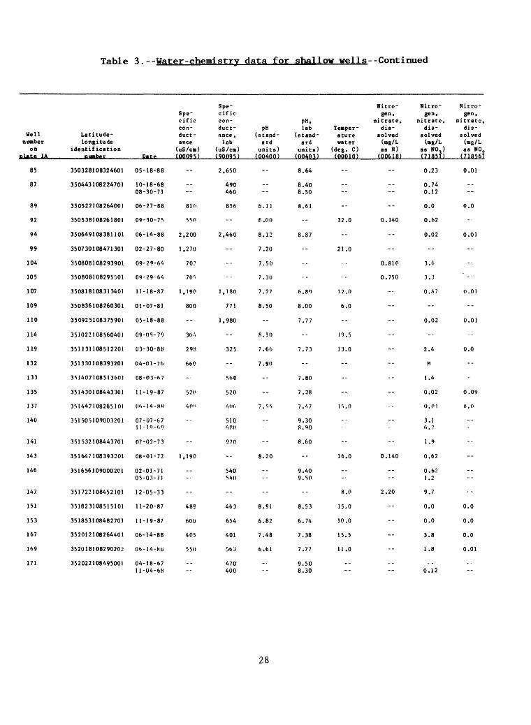
Table 3.--Water-chemistry data for shallow wells--Continued
Well number
onplate 1A
85
87
89
92
94
99
104
105
107
109
110
114
119
132
133
135
137
140
141
143
146
147
151
153
167
169
171
Latitude- longitude
identification
350328108324601
350443108224701
350522108264001
350538108261801
350649108381101
350730108471301
350808108293901
350808108295501
350818108313401
350836108260301
350925108375901
351022108560401
351131108512201
351330108393201
351407108513601
351430108443301
351442108265101
351505109003201
351532108443701
351647108393201
351656109000201
351722108452101
351823108515101
351853108482701
352012108264401
352018108290201!
352022108495001
Date
05-18-88
10-18-68 08-30-71
06-27-88
09-30-75
06-14-88
02-27-80
09-29-64
09-29-6/1
11-18-87
01-07-81
05-18-88
09-05-79
03-30-88
04-01-76
08-03-67
11-19-87
()f>-14-HH
07-07-67 1 1-19-M)
07-02-73
08-01-72
02-01-71 05-03-71
12-05-33
11-20-87
11-19-87
06-14-88
06-14-80
04-18-67 11-04-68
Spe
cific con duct ance
(uS/cm) (00095)
--
--
810
S50
2.200
1.270
70?
70^
1,190
800
--
30-'.
298
660
-
520
/,(>"
--
--
1,190
--
--
48S
600
405
550
--
Spe cific con duct ance,
lab (uS/cm) (90095)
2.650
490 460
856
--
2.460
--
--
...
1,180
771
1.980
--
325
--
560
520
/i (id
510/ PI)
970
--
540
--
463
654
401
363
470 400
pH (stand
ard units)
(00400)
--
--
8.11
e.oo
8.12
7.20
7.50
7.30
7.27
8.50
--
8.10
7.66
7.90
--
--
7.S-'.
--
--
8.20
--
--
8.91
6.82
7.48
6.61
-
pH. lab Temper-
(stand- ature ard water
units) (deg. C) (00403) (00010)
8.64
8.40 8.50
8.61
32.0
8. 37
21.0
--
6.89 12.0
8.00 6.0
7.77
19.5
7.73 13.0
--
7.80
7.28
7./i7 1S.O
9.30 8.90
8.60
16.0
9.40 9.50
8.0
8.53 15.0
6.74 10.0
7.38 15.5
7.77 11.0
9.50 8.30
Nitro- Nitro gen, gen,
nitrate, nitrate, dis- dis
solved solved (mg/L (mg/L as N) as NO.)
(00618) (71851)
0.23
0.74 0.12
0.0
0.140 0.62
0.02
--
0.810 3.6
0.750 3.3
0./i7
--
0.02
--
2.4
M
1.4
0.02
0.01
3.1
1.9
0.140 0.62
0.62 1.2
2.20 9.7
0.0
0.0
3.8
1.8
0.12
Nitro gen,
nitrate, dis
solved (mg/L as NO
(718567
0.01
--
0.0
-
0.01
--
0.01
--
0.01
--
0.0
---
0.09
0.0
--
------
--
0.0
0.0
0.0
0.01
28
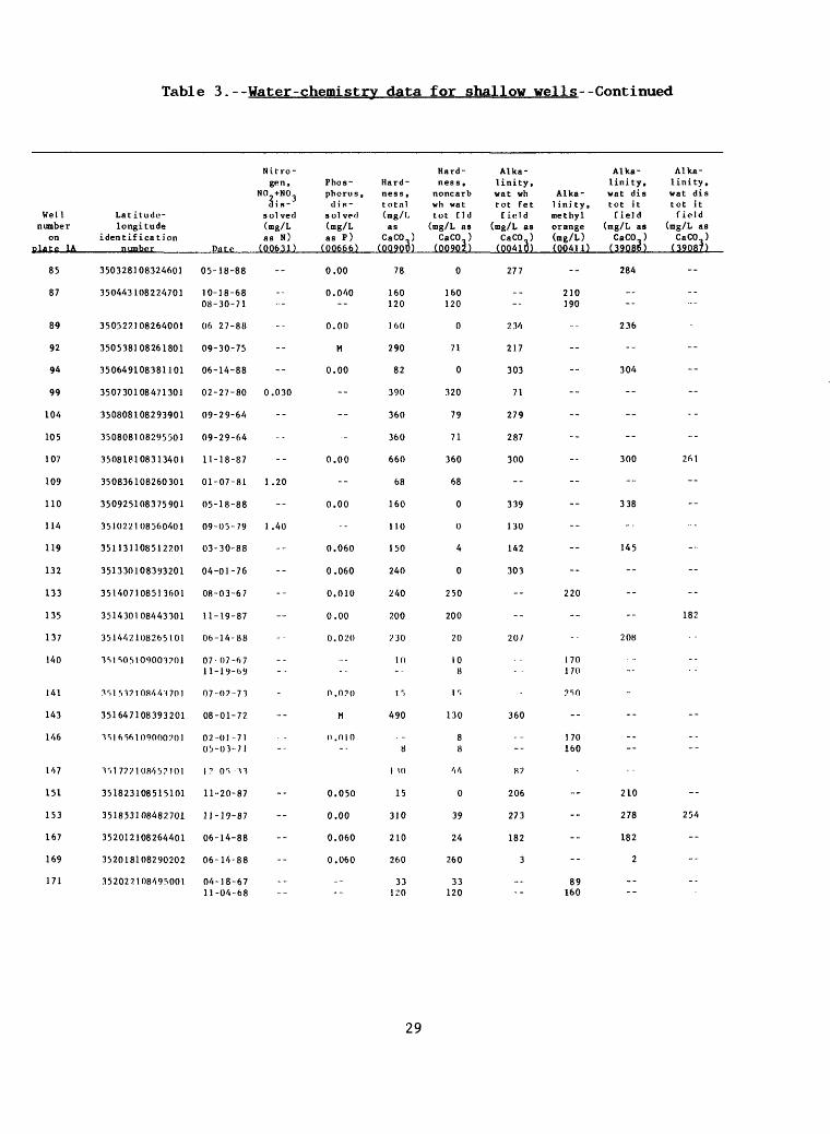
Table 3.--Water-chemistrv data for shallow wells--Continued
Well number
on plate 1A
85
87
89
92
94
99
104
105
107
109
110
114
119
132
133
135
137
140
141
143
146
147
151
153
167
169
171
Latitude- longitude
identification number
350328108324601
350443108224701
350527108264001
350538108261801
350649108381101
350730108471301
350808108293901
350808108295501
350818108313401
350836108260301
350925108375901
351022108560401
351131108512201
351330108393201
351407108513601
351430108443301
351442108265101
1SIS05I09001701
ISIS!? I 08441 701
351647108393201
1 r>l 6561 0900020 1
T>17??10845?101
351823108515101
351853108482701
352012108264401
352018108290202
352022108495001
Date
05-18-88
10-18-6808-30-71
Of> 27-88
09-30-75
06-14-88
02-27-80
09-29-64
09-29-64
11-18-87
01-07-81
05-18-88
09-05-79
03-30-88
04-01-76
08-03-67
11-19-87
06-14-88
07-07-6711-19-09
07-07-71
08-01-72
02-01-7105-03-71
\? 0 r > 1 1
11-20-87
11-19-87
06-14-88
06-14-88
04-18-6711-04-68
Nitrogen,
NO +N03 d i s-
sol ved (mg/L as N)
(00631)
--
-....
--
--
--
0.030
--
--
--
1.20
--
1.40
--
--
--
-
--
-
--
--
--
--
--
--
--._
Phos phorus, ilis-
sol ve<l (mg/L as P)
(00666)
0.00
0.040--
0.00
M
0.00
--
--
-
0.00
--
0.00
--
0.060
0.060
0.010
0.00
0.020
...--
0.070
M
(1.0 10--
0.050
0.00
0.060
0.060
----
Hard ness, total (mg/L as
CaCO ) (00900)
78
160120
!()()
290
82
390
360
360
660
68
160
110
150
240
240
200
230
10--
I r>
490
8
1 10
15
310
210
260
33K!0
Hardness,
noncarb wh vat tot tld
(mg/L as CaCO )
(00902)
0
160120
0
71
0
320
79
71
360
68
0
0
4
0
250
200
20
108
r.
130
88
'i4
0
39
24
260
33120
Alkalinity, wat wh tot fet finld
(mg/L as CaCO )
(00410)
277
._--
2.14
217
303
71
279
287
300
--
339
130
142
303
--
--
20/
360
--
87
206
273
182
3
_---
Alkalinity,
Alka- wat dis linity. tot it methyl field orange (mg/L as (mg/L) CaCO ) (00411) (39086)
284
210190
2.16
..
304
--
-.
..
300
--
338
--
145
--
220
--
208
1 70170
7 r>0
--
170160
210
278
182
2
89160
Alkalinity, wat dis tot it field
(mg/L as CaCO )
(39087)
-
--
--
--
--
--
--
261
-
--
--
--
--
182
--
--
----
--
254
--
...
--
29
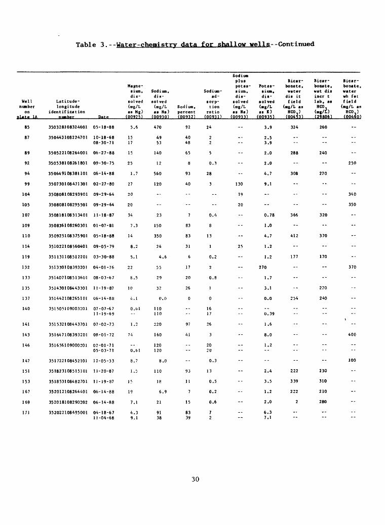
Table 3.--Water-chemistry data for shallow wells--Continued
Well number
on
85
87
89
92
94
99
104
105
107
109
110
114
119
132
133
135
137
140
141
143
146
147
151
153
167
169
171
Latitude- longitude
identificationpiimhpr
350328108324601
350443108224701
350522108264001
350538108261801
350649108381101
350730108471301
350808108293901
350808108295501
350818108313401
350836108260301
350925108375901
351022108560401
351131108512201
351330108393201
351407108513601
351430108443301
351442108265101
351505109003201
351532108443701
351647108393201
351656109000201
351722108452101
351823108515101
351853108482701
352012108264401
352018108290202
352022108495001
Date
05-18-88
10-18-6808-30-71
06-27-88
09-30-75
06-14-88
02-27-80
09-29-64
09-29-64
11-18-87
01-07-81
05-18-88
09-05-79
03-30-88
04-01-76
08-03-67
11-19-87
06-14-88
07-07-671 1-19-69
07-02-73
08-01-72
02-01-7105-03-71
12-05-33
11-20-87
1J-19-87
06-14-88
06-14-88
04-18-6711-04-68
Magne sium, dis
solved (mg/L as Mg)(Q0925)
5.6
1517
15
25
1.7
27
20
20
34
7.3
14
8.2
5.1
22
6.5
10
4.1
0.01--
1 .2
74
-.0.61
8.7
1.5
1?
19
7.1
4.39.1
Sodium, dis
solved (mg/L as Na)(00930)
470
4953
140
12
560
120
--
--
23
150
350
24
4.6
55
29
32
0.0
110110
220
160
120120
8.0
110
18
6.9
21
9138
Sodium, percent (Q0932)
92
4048
65
8
93
40
--
--
7
83
83
31
6
17
20
26
0
.---
97
41
----
--
93
11
7
15
8339
Sodium- ad-
sorp- t ion
ratio (OQ931)
24
22
5
0.3
28
3
--
--
0.4
8
13
1
0.2
2
0.8
)
0
1617
26
3
2020
0.3
13
0.5
0.2
0.6
72
Sod i UK plus Bicar- Bicar- potas- Potaa- bonate. Donate, sium, slum, water wat dis dis- dis- dis it incr t
solved solved field lab, as (mg/L (mg/L (mg/L as RCO. as Na) as K) NCO.) (mg/L) (00933) (00935) (00453) (29806)
3.9 324 260
2.53.9
2.0 288 240
2.0
4.7 308 270
130 9.1
19
20
0.78 366 320
1.0
4,7 412 370
25 1.2
1.2 177 170
270
1.7
3.1 -- 220
0.0 254 240
..0.39
1.6
8.0
1.2--
--
2.4 222 230
3.5 339 310
1.2 222 210
2.0 2 280
6.37.1
Bicar bonate, water wh fetfield (mg/L as HCO.) (00440)
--
..--
--
250
--
--
340
350
--
-
--
--
--
370
--
...
--
----
--
400
----
100
------------
30

Table 3.--Water-chemistry data for shallow wells--Continued
Well number
on plate 1A
85
87
89
92
94
99
104
105
107
109
110
114
119
132
133
135
137
140
141
143
146
147
151
153
167
169
171
Latitude- longitude
identification
350328108324601
350443108224701
350522108264001
350538108261801
350649108381101
350730108471301
350808108293901
350808108295501
350818108313401
350836108260301
350925108375901
351022108560401
351131108512201
351330108393201
351407108513601
351430108443301
351442108265101
351505109003201
351532108443701
351647108393201
351656109000201
351722108452101
351823108515101
351853108482701
352012108264401
352018108290202
352022108495001
Date
05-18-88
10-18-68 08-30-71
06-27-88
09-30-75
06-14-88
02-27-80
09-29-64
09-29-64
11-18-87
01-07-81
05-18-88
09-05-79
03-30-88
04-01-76
08-03-67
11-19-87
06-14-88
07-07-67 11-19-69
07-02-73
08-01-72
02-01-71 05-03-71
12-05-33
11-20-87
11-19-87
06-14-88
06-14-88
04-18-67 11-04-68
Car bonate, water
dis it field
(mg/L as CO,)
(00452)
11
--
0
--
31
--
--
--
0
--
0
--
0
------
0
--
------
--
17
0
0
0
--
Car bonate, wat dis incr t lab. asC03
(mg/t)(29809)
19
--
27
--
0
--
--
--
0
--
0
--
0
----
0
0
--
------
--
0
0
0
0
--
Car bonate, water
wh fet field
(mg/L as CO.)
(00445)
--
--
--
7
--
--
0
0
---------
M
--
--
--
--
--
19
--
0
-
--
--
--
--
Chlo
ride, dis
solved (mg/L as Cl) (00940)
300
16 16
11
7.5
390
34
13
13
23
52
11
7.2
4.6
11
29
43
4.1
17 9.9
43
60
12 8.2
20
10
28
7.8
32
22 3.9
Sulfate, dis solved (mg/L
as SO.) (00945)
450
27 26
220
84
500
540
81
81
400
31
580
11
10
53
31
16
18
33 16
120
200
28 33
24
54
48
19
24
110 41
Fluo- Silica, ride, dis- Arsenic, dis- solved dis solved (mg/L solved (mg/L as (ug/L as F) SiO.) as As) (00950) (00955) (01000)
2.5 -- <1
0.17 0.27
0.28 -- <1
0.40
2.9 -- <1
0.60 4.4 2
0.30 13
0.30 12
0.33 -- <1
0.60 11
0.36 -- <1
0.30 21
0.13 -- 3
0.98
0.55
0.16 -- <1
0.18 -- 2
0.35 0.45
0.72
0.60
0.60 0.66
0.0
0.35 3
0.12 -- <1
0.25 -- 2
0.82 -- 5
0.55 0.30
Barium, dis solved (ug/L ae Ba) (01005)
170
--
190
--
130
20
--
--
350
--
310
--
650
--
--
400
750
--
--
--*
--
--
50
380
350
370
31

Table 3.--Water-chemistry data for shallow wells--Continued
Well number
on nlate 1A
85
87
89
92
94
99
104
105
107
109
110
114
119
132
133
135
137
140
141
143
146
147
151
153
167
169
171
Latitude- longitude
identificationnubfv
350328108324601
350443108224701
350522108264001
350538108261801
350649108381101
350730108471301
350808108293901
350808108295501
350818108313401
350836108260301
350925108375901
351022108560401
351131108512201
351330108393201
351407108513601
351430108443301
351442108265101
351505109003201
351532108443701
351647108393201
351656109000201
351722108452101
351823108515101
351853108482701
352012108264401
352018108290202
352022108495001
Date
05-18-88
10-18-6808-30-71
06-27-88
09-30-75
06-14-88
02-27-80
09-29-64
09-29-64
11-18-87
01-07-81
05-18-88
09-05-79
03-30-8i»
04-01-76
08-03-67
11-19-87
06-14-88
07-07-671 1-19-69
07-02-73
08-01-72
02-01-7105-03-71
12-05-33
11-20-87
11-19-87
06-14-88
06-14-88
04-18-6711-04-68
Chro- Boron, Cadmium, mi urn, dis- dis- dis
solved solved solved (ug/L (ug/L (ug/L as B) as Cd) as Cr)
(01020) (0}025) (OJ030)
1,900 <1 <1
--
550 <1 <1
M
980 <1 <1
16 0
--
--
0 <1 <1
280
960 <1 <1
--
280 <1 <1
190
250
0 <1 <1
1.300 '1 '1
500250
180
200
360360
--
0 <1 <1
0 <1 <1
690 <1 <1
550 <1 <1
._
._
Iron, total Iron, recov- dis- erable solved (ug/L (ug/L as Fe) as Fe)
(01045) (01046)
15
70--
20
M
10
800
10 0
140 50
1,200
20
10
60
25
M
70
1,600
1,900
230190
140
0
270350
--
10
<10
15
15
40110
Manga - Lead, nese, die- dis
solved solved (ug/L (ug/L as Pb) as Mn)
(01049) (01056)
<1 6
--
<1 82
--
<1 6
0 340
--
'-
<1 260
2
<1 220
20
<1
--
--
<l 48
2 480
_---
--
--
..--
--
<1 10
<1 34
<1 4
<1 <4
__--
32

Table 3.--Water-chemistry data for shallow wells--Concluded
Wellnumber
on olatp 1A
85
87
89
92
94
99
104
105
107
109
110
114
119
132
133
135
137
140
141
143
146
147
151
153
167
169
171
Latitude-longitude
ident if ication
350328108324601
350443108224701
350522108264001
350538108261801
350649108381101
350730108471301
350808108293901
350808108295501
350818108313401
350836108260301
350925108375901
351022108560401
351131108512201
351330108393201
351407108513601
351430108443301
351442108265101
351505109003201
351532108443701
351647108393201
351656109000201
351722108452101
351823108515101
351853108482701
352012108264401
352018108290202
352022108495001
Sele-Mercury, niutn,
di s- di s- solvcd solvrd(ug/L (ug/L as Hg) as Se)
Date (71890) (01145)
05-18-88 <0.2 <2
10-18-6808-30-71
06-27-88 <0.2 <2
09-30-75
06-14-88 <0.: <2
02-27-80 0 0
09-29-64
09-29-64
11-18-87 <0.2 <2
01-07-81
05-18-88 <0.2 <2
09-05-79
03-30-88 <0.2 <-2
04-01-76
08-03-67
11-19-87 <0.2 <2
06-14-88 <0.2 <2
07-07-6711-19-69
07-02-73
08-01-72
02-01-7105-03-71
12-05-33
11-20-87 <0.2 <2
11-19-87 <0.2 <2
06-14-88 <0.2 <?
06-14-88 <0.2 <2
04-18-6711 -04 -(.8
ElevationPotas- of land-
Silver, siutn 40, surface Total Totaldis- dis- datum depth depth
solvrcl solved (feet of of(ug/L (pCi/L above hole well as Ag) as K-40) sea level) (feet) (feet)
(01075) (82068) (72000) (72001) (72008)
<1.0 -- -- -- 707.00
7,150 -- 388.007.150 -- 388.00
<1.0 -- 7.070 -- 565.00
7.096
<1.0 -- -- -- 282.00
0 -- 6,441 -- 1.175.00
120.00
112.00
<1.0 -- -- -- 227.00
0.70 7.130 120 120.00
<1.0 -- -- -- 760.00
7,020 -- 500.00
<t.O -- -- -- 94.00
6,868 -- 583.00
86.00
<1.0 -- -- -- 635.00
<1.0 -- -- -- 100.00
541.00541 .00
749.00
6,860 -- 100.00
565.00565.00
44.00
<1.0 -- -- -- 832.00
<1 .0 -- -- -- 497.00
<1.0 -- -- -- 75.00
<1.0 -- 7,922 -- 190.00
591.00591.00
Waterlevelbel ow land
surface (feet) (72019)
--
---
--
--
--
--
40. OP
20.00
--
...
--
227.10
--
--
--
--
--
--
--
--
--
35.00
--
--
--
--
_-
US GOVERNMENT PRINTING OFFICE 199O-833-O12
33