arcgis for mobile devices: an overview · 2013-03-22 · positioning and benefits . key benefits of...
TRANSCRIPT

ArcGIS for Mobile Devices: An Overview Jeff Shaner Bonnie Stayer
Agenda
• Esri Positioning and Key Benefits • Your Mobility Strategy • Q & A

Positioning and Benefits

Key Benefits of Mobile Solutions Leverage your investment in ArcGIS
Make Informed and Timely Decisions
Seamless Data
Integration
Rapid Data
Collection
Improve Efficiency
and Accuracy

• Online (public or private cloud) • Server (on premises or private cloud) • Desktop • Mobile/devices • Content
ArcGIS is a Complete System Managing and working with geographic information
Many deployment options
Cloud
Enterprise
Web
Mobile
Desktop
• Visualize • Create • Collaborate • Discover • Manage • Analyze

iOS Windows Phone
Android Linux
Windows Mobile
Windows 7
Platforms
Esri Mobile Technologies Mobile capabilities of the ArcGIS system
ArcGIS Form Factors
Apps and APIs
Functionality (Mobility Services)

Windows Mobile
Windows
iOS Android
Runtime SDK .NET
Runtime SDK WPF, Java
Linux
Runtime SDK Java
Runtime SDK Objective C
Runtime SDK Java
Windows Phone
Runtime SDK Silverlight
Apps ArcGIS
Apps ArcGIS, AGX
Apps ArcGIS
Apps ArcGIS
Apps ArcGIS
Device Platforms

Your Mobile Strategy

Mobile Technology for the Knowledge Worker
ArcGIS
Field Operations
Planning and Logistics
Public Engagement

Mobile Technology for the Knowledge Worker
ArcGIS
Field Operations
Planning and Logistics
Public Engagement

Field Operations
5 Key Workflows 1. Replace paper map books 2. Map infrastructure 3. Maintain infrastructure 4. Replace paper surveys 5. Respond to events
Disconnected use Data Entry Forms Location Tracking Routing and Nav Intelligent Search Field Sync High Accuracy GPS Assigned Tasks …
Capabilities Rugged Handhelds Laptops Tablets Smartphones
Platforms

ArcPad
• Full Featured Mobile GIS App • Ad-hoc data collection projects • High accuracy GPS • Configurable • Custom forms • Fully Disconnected • Users typically need GIS Training
Windows 7/8 Laptops
Windows Mobile handhelds

ArcGIS for Windows Mobile
• Configurable workflows • High accuracy GPS • Custom forms • Fully disconnected • ArcGIS Online/ArcGIS Server
Packaging and Deployment • Users typically need little training - .NET/CF API for Windows
Tablet/Mobile - Applications are extensible!
Windows 7/8 Laptops
Windows Mobile handhelds

Trimble Positions
• Enhances data collection capabilities - Ensures Positional accuracy - Supports post-processing of GPS positions - Enables VRS/RTC connection to corrected positions - Geo Explorer series, Juno series and Nomad devices
• ArcGIS for Windows Mobile - Extends ArcGIS field app
(Windows Mobile platform only) - Extends SDK
• ArcPad - GPS Correct Extension

Bonnie Stayer Demo

• Collect new GIS features using map or GPS • Complete intelligent data entry forms • Attach photos and video • Find places and points of interest • Get driving directions to places and features • Measure distance and area • Location tracking
Collector
iPhone, Android Phone devices

Bonnie Stayer Demo

Mobile Technology for the Knowledge Worker
ArcGIS
Field Operations
Planning and Logistics
Public Engagement

Planning and Logistics
3 Key Workflows 1. Monitor and Manage Operations 2. Share plans 3. Present to stakeholders
Live maps Graphs Indicators Charts Presentations Story telling Redlining Dispatching Sharing …
Capabilities Tablets Laptops Smartphones
Platforms
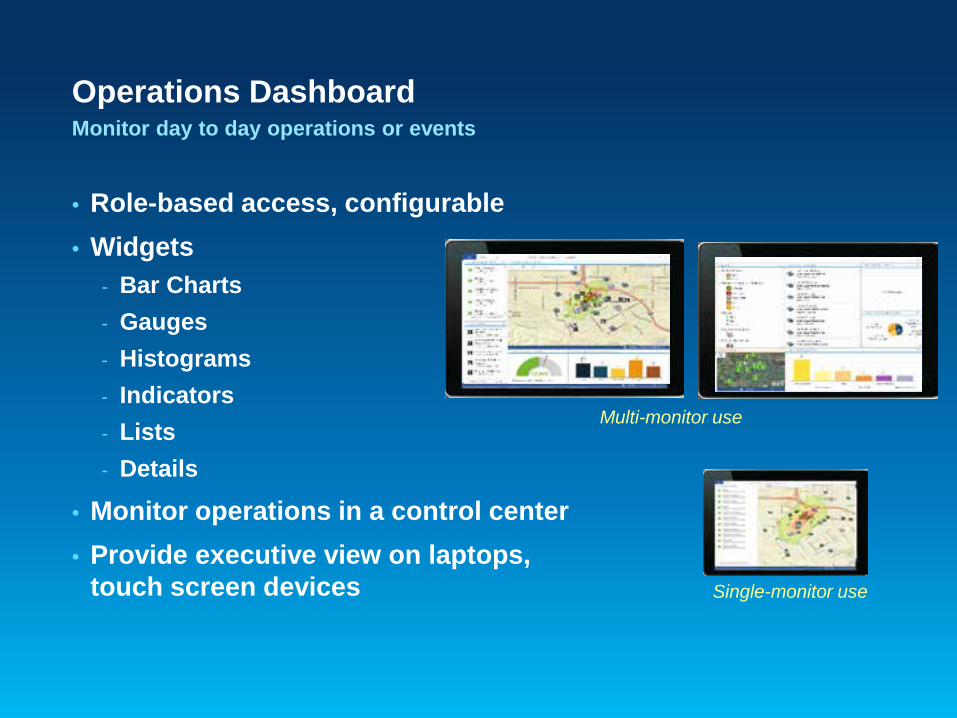
• Role-based access, configurable • Widgets
- Bar Charts - Gauges - Histograms - Indicators - Lists - Details
• Monitor operations in a control center • Provide executive view on laptops,
touch screen devices
Operations Dashboard Monitor day to day operations or events
Single-monitor use
Multi-monitor use

ArcGIS App Map viewing and display
• Role-based access • View and Share Maps • ArcGIS Online/ArcGIS Server
access • Popups • Search • Redlining • Online access only

Bonnie Stayer Demo

Mobile Technology for the Knowledge Worker
ArcGIS
Field Operations
Planning and Logistics
Public Engagement

Public Engagement
3 Key Workflows 1. Tell Stories 2. Inform Citizens 3. Crowd Source information
Live maps Graphs Indicators Charts Presentations Story telling Redlining Data Collection Sharing …
Capabilities Tablets Laptops Smartphones Web browsers
Platforms

ArcGIS Online Web Application Templates
• Standard Viewers • Story Telling Viewers

ArcGIS Runtime SDKs and Web APIs
Native ArcGIS Runtime SDKs • Build focused, branded applications • Rapid development with ArcGIS Online

Bonnie Stayer Demo

• Exhibitors • I am GIS Photo Booth & Trading Cards • Hands-On Learning & Coaching Labs • Design Studio • Spatial Outlet • Esri Showcase • GIS Technical & Extended Support • 2 Demo theaters • Drinks & snacks
In the GIS Solutions EXPO
Don’t Miss These Attractions

6:30 PM–9:30 PM • Walking distance from convention center
• Conference Badge needed for reception
• Coat check available in courtyard
• Serving hot hors d’oeuvres and beverages
Smithsonian American Art Museum and National Portrait Gallery
Tuesday Evening Reception

11:30 AM–1:30 PM • Ballrooms A–C, Third Level
• Join conference attendees for lunch and closing session
• Closing Speaker Todd Park, U.S. CTO
• Wrap-up and request for feedback with Jack Dangermond.
Closing and Hosted Lunch
Wednesday Closing Session

Upcoming Events esri.com/events
Date Event Location
March 21, 2013 MeetUp – ArcGIS Platform Washington, DC
April 18, 2013 MeetUp – Location Analytics Washington, DC
March 23–26, 2013 Esri Partner Conference Palm Springs, CA
March 25–28, 2013 Esri Developer Summit Palm Springs, CA
July 6–9, 2013 Esri National Security Summit San Diego, CA
July 8–12, 2013 Esri International User Conference San Diego, CA

Thank You Please complete a session evaluation form.
#FedGIS
