arcgis server: esri's enterprise gis application server
TRANSCRIPT
ESRI 380 New York St., Redlands, CA 92373-8100, USA • TEL 909-793-2853 • FAX 909-793-5953 • E-MAIL [email protected] • WEB www.esri.com
ArcGIS® Server: ESRI's Enterprise GIS Application Server
An ESRI
® White Paper • February 2004

Copyright © 2004 ESRI All rights reserved. Printed in the United States of America. The information contained in this document is the exclusive property of ESRI. This work is protected under United States copyright law and other international copyright treaties and conventions. No part of this work may be reproduced or transmitted in any form or by any means, electronic or mechanical, including photocopying and recording, or by any information storage or retrieval system, except as expressly permitted in writing by ESRI. All requests should be sent to Attention: Contracts Manager, ESRI, 380 New York Street, Redlands, CA 92373-8100, USA. The information contained in this document is subject to change without notice.
U.S. GOVERNMENT RESTRICTED/LIMITED RIGHTS Any software, documentation, and/or data delivered hereunder is subject to the terms of the License Agreement. In no event shall the U.S. Government acquire greater than RESTRICTED/LIMITED RIGHTS. At a minimum, use, duplication, or disclosure by the U.S. Government is subject to restrictions as set forth in FAR §52.227-14 Alternates I, II, and III (JUN 1987); FAR §52.227-19 (JUN 1987) and/or FAR §12.211/12.212 (Commercial Technical Data/Computer Software); and DFARS §252.227-7015 (NOV 1995) (Technical Data) and/or DFARS §227.7202 (Computer Software), as applicable. Contractor/Manufacturer is ESRI, 380 New York Street, Redlands, CA 92373-8100, USA. ESRI, the ESRI globe logo, ArcGIS, ArcSDE, ArcObjects, ArcIMS, ArcEditor, ArcView, ArcInfo, www.esri.com, and @esri.com are trademarks, registered trademarks, or service marks of ESRI in the United States, the European Community, or certain other jurisdictions. Other companies and products mentioned herein are trademarks or registered trademarks of their respective trademark owners.
J-9189
ESRI White Paper i
ArcGIS Server: ESRI's Enterprise GIS Application Server
An ESRI White Paper Contents Page Executive Summary .............................................................................. 1 Vision of a Centrally Managed GIS...................................................... 1 Delivery of Focused GIS Applications ................................................. 2 Open Platform....................................................................................... 2 Lower Cost of Ownership..................................................................... 3 Scalability ............................................................................................. 3 Examples of How ArcGIS Server Can Be Used................................... 3 Conclusion ............................................................................................ 5 Appendix Frequently Asked Questions ................................................................. 6
Why Is ArcGIS Server Attractive to Central IT Organizations? .... 6 How Can I Use ArcGIS Server? ..................................................... 7 How Will Existing Users Deploy ArcGIS Server?......................... 7 Can I Use ArcGIS Server to Deploy ArcView on a Server? .......... 7 Can I Create Web Services With ArcGIS Server?.......................... 7
J-9189
ESRI White Paper
ArcGIS Server: ESRI's Enterprise GIS Application Server
Executive Summary With ArcGIS® 9, ESRI is introducing a new technology for supporting enterprise geographic information system (GIS) implementations. ArcGIS Server takes a centralized approach to implementing GIS solutions. This approach helps reduce the cost of GIS ownership by centralizing installation and management and by implementing the GIS enterprise application server software on the organization's standard server hardware; the need to install and maintain software on distributed PCs is reduced significantly. Furthermore, the centralization of data management and application support offered by ArcGIS Server, combined with its adherence to information technology (IT) standards, make ArcGIS Server a significant milestone on the road to broad use of geospatial technology within enterprise information systems.
Vision of a Centrally Managed GIS
ArcGIS Server is the first true enterprise GIS application server. It enables the implementation of GIS business logic in an IT standards-based server environment. Previously, this business logic was available only in GIS desktop solutions. ArcGIS Server allows users throughout the enterprise—at the main office or regional offices, at home or in the field—to access GIS capabilities via a single shared system. The organization can build one solution and deploy it to a host of users. With this centralized approach to data management and application support, users of particular GIS applications (e.g., transaction systems such as utilities and land records) will develop server-based business logic for their applications and make it available on demand using a mix of thin/thick and mobile/stationary clients. ArcGIS Server exposes the full depth of ESRI's geospatial capabilities using open, standards-based application program interfaces (APIs). This standards-based approach allows ArcGIS Server to provide geospatial capabilities to a wide range of distributed users. ArcGIS Server will produce a new group of spatial information consumers—knowledge workers who are not trained GIS professionals—who will benefit from access to the information provided by custom, GIS-powered applications. For some users, this technology will move GIS into the same enterprise category as enterprise resource planning (ERP) or customer relationship management (CRM).

ArcGIS Server: ESRI's Enterprise GIS Application Server
J-9189
February 2004 2
Delivery of Focused GIS Applications
ArcGIS Server provides a wealth of server-based GIS functionality. Its capabilities include mapping, geocoding, spatial queries, editing, tracing, and high-end analysis. Because this functionality is server based, it can readily be served to end users who do not have a desktop GIS. Examples of applications that developers can build for end users who do not have a desktop GIS include facility network modeling, property management, land records, forest management, transportation monitoring, customer service, geomarketing, logistics planning, and others. ArcGIS Server will not make obsolete what users currently do on the desktop. The applications developed using ArcGIS Server will provide the opportunity to create and serve up a whole class of advanced GIS server applications that go beyond simple mapping. Many existing users will add ArcGIS Server to their ArcSDE® environment and leverage the investment in the geodatabase across their organizations.
Open Platform ArcGIS Server adheres to IT standards, providing maximum interoperability and compatibility with enterprise architectures using any of a variety of popular programming languages, development environments, commercial application servers, and database management systems (DBMSs). Key standards, such as Java™ and .NET, Extensible Markup Language (XML)/Simple Object Access Protocol (SOAP) for messaging and data transfer over Web (HTTP) network connections can be used to build local and wide area network enterprise applications. Such standards offer a rich environment with maximum flexibility for communicating with the organization's heterogeneous operational applications and information assets, thus fostering the implementation of true
ArcGIS Server: ESRI's Enterprise GIS Application Server
J-9189
ESRI White Paper 3
enterprise applications. With this open environment, organizations can provide geospatial capabilities to a wide range of distributed users. ArcGIS Server represents a significant technological step toward the broad use of geospatial technology within enterprise information systems.
Lower Cost of Ownership
With ArcGIS Server, all processing capabilities are centralized, so software updates do not need to be installed on hundreds of PCs. This significantly reduces the administrative cost of version synchronization, certification, and installation across the organization. GIS enterprise application server software can be implemented on an organization's standard server hardware, and the same IT staff can be used to maintain both.
Scalability As more users need to be served by enterprise GIS applications, capability can be easily increased by upgrading the memory or disk in an existing server machine or by adding more ArcGIS Server instances. The load can be readily shared and balanced between these multiple instances with the administrative tools specifically designed to support system administrators.
Examples of How ArcGIS Server Can
Be Used
With ArcGIS Server, you can create seemingly simple applications that potentially use very sophisticated functionality and a large volume of data. These applications can be used on both mobile and desktop systems. As a result, ArcGIS Server can be implemented successfully in virtually any industry. Below are a few examples of industry specific implementations. Petroleum Industry
● Gridding/Contouring, volume calculations, and complex modeling processes until
now have been performed on each desktop. ArcGIS Server allows these processes to be performed in the background by a server class machine, freeing the desktop from this heavier processing load and allowing a lighter weight client to be used.
Electric and Gas Industry
● Electric and gas companies rely extensively on staff in the field to record their
firsthand observations of the condition of infrastructure. Routinely, utilities perform both mandatory (required by regulatory agencies) and voluntary inspections to assess the condition of the facilities. Examples include valve, pole, and pad mount equipment inspections. Today, mobile field staff can use wireless handheld devices, acting as clients to ArcGIS Server, to capture data and dynamically update the corporate facilities' archive.
● The call center for a gas utility company could use ArcGIS Server in the
following way: Customers telephone the call center and report a strong smell of gas in the neighborhood. The call center would use a browser to enter the customer's name and address and send a request to ArcGIS Server. ArcGIS Server can then perform a trace on the gas pipe network to find the upstream gas main to the customer's address and determine which valve needs to be shut down. ArcGIS Server instantly sends back to the browser client a map of the network trace; the location of the valve that needs to be turned off; and a listing with names, addresses, and phone numbers of all the customers who would be affected by shutting off the valve. This entire process is accomplished without having to
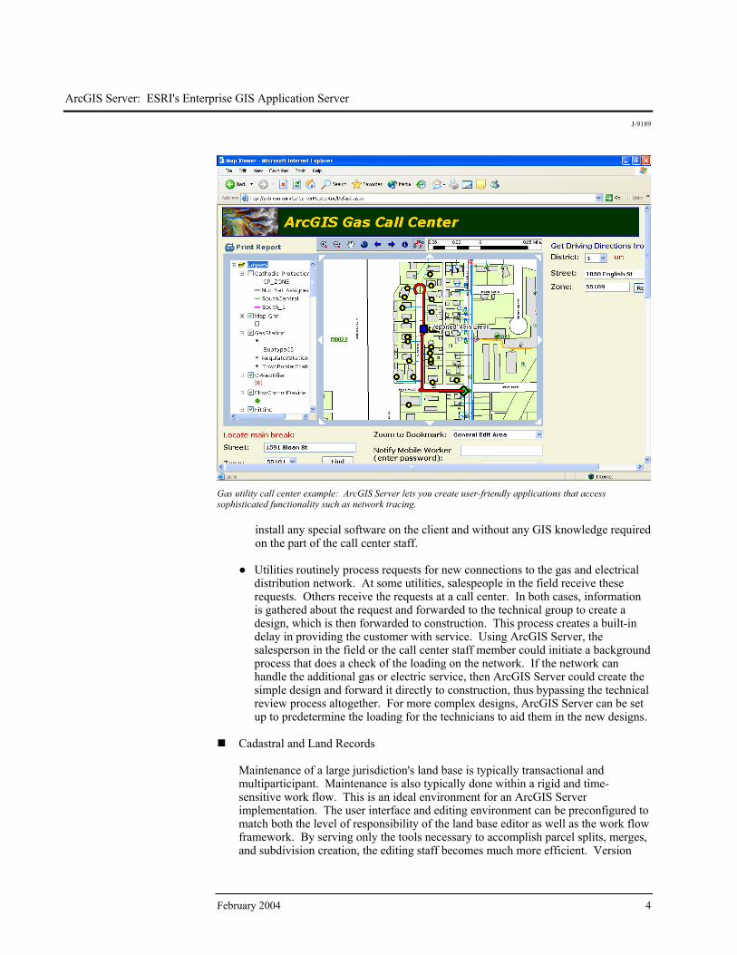
ArcGIS Server: ESRI's Enterprise GIS Application Server
J-9189
February 2004 4
Gas utility call center example: ArcGIS Server lets you create user-friendly applications that access sophisticated functionality such as network tracing.
install any special software on the client and without any GIS knowledge required on the part of the call center staff.
● Utilities routinely process requests for new connections to the gas and electrical
distribution network. At some utilities, salespeople in the field receive these requests. Others receive the requests at a call center. In both cases, information is gathered about the request and forwarded to the technical group to create a design, which is then forwarded to construction. This process creates a built-in delay in providing the customer with service. Using ArcGIS Server, the salesperson in the field or the call center staff member could initiate a background process that does a check of the loading on the network. If the network can handle the additional gas or electric service, then ArcGIS Server could create the simple design and forward it directly to construction, thus bypassing the technical review process altogether. For more complex designs, ArcGIS Server can be set up to predetermine the loading for the technicians to aid them in the new designs.
Cadastral and Land Records
Maintenance of a large jurisdiction's land base is typically transactional and multiparticipant. Maintenance is also typically done within a rigid and time-sensitive work flow. This is an ideal environment for an ArcGIS Server implementation. The user interface and editing environment can be preconfigured to match both the level of responsibility of the land base editor as well as the work flow framework. By serving only the tools necessary to accomplish parcel splits, merges, and subdivision creation, the editing staff becomes much more efficient. Version
ArcGIS Server: ESRI's Enterprise GIS Application Server
J-9189
ESRI White Paper 5
reconciliation and topological validation can all be performed on the server utilizing a single consistent rule set. A streamlined user interface, a preset editing environment, conformance to work flow, and serverside geoprocessing all contribute to much more efficient land base maintenance. An added benefit realized from serving only a subset of ArcGIS tools is the ability to run the editing application on a lower end PC.
Conclusion The very extensive functionality and ability to deal with terabytes of data, as well as the
standards-based approach, make ArcGIS Server ideal for providing GIS capabilities to a wide range of distributed users. In addition, the lower cost of ownership and scalability embodied in ArcGIS Server means that organizations can create compelling business cases that demonstrate a good return on investment. As a result, ESRI expects that numerous organizations new to GIS will build systems based on this architecture. In addition, many existing GIS organizations will use ArcGIS Server to efficiently offer access to their GIS applications throughout the enterprise. ArcGIS Server represents a significant milestone in ESRI's software development evolution that will further integrate GIS with the larger IT environment so the benefits of spatially enabled information can be shared with a greater number of people at a lower cost.
J-9189
February 2004 6
Appendix: Frequently Asked Questions
Why Is ArcGIS Server Attractive to
Central IT Organizations?
ArcGIS Server enables the development of server-oriented applications. The architecture of ArcGIS Server will be attractive to the information technology department in an organization because it provides centralized serving of GIS across an enterprise. It will not replace the need for desktop GIS; its focus is on increasing access to the geodatabase for viewing, analysis, and simple updating. It will primarily be used to support server-based mapping, geocoding, analysis, and focused applications accessed across an organization. Key benefits to central IT organizations include the following: Occurrence of processing close to the data within the network space
Ability to create single, centralized applications (easy, low-cost installation, upgrade,
and maintenance) Ease of integration with other enterprise information systems
Ability to develop focused applications that use functionality that can be either basic
or sophisticated and that use large or small volumes of data Ability for enterprise-oriented GIS developers to build highly customized,
distributed applications using industry standard tools (Java and .NET) ESRI envisions that ArcGIS Server will initially be implemented primarily as an Intranet/enterprise GIS server within departments and related organizations. Some examples of how it can be implemented include the following: Build and serve centrally managed Web applications such as custom map viewers
and simple updating using .NET/Active Server Pages or Java/JavaServer Pages. Centrally manage geographic information and functions, such as maps, data, and
geocoding locators, as shared Web services. Build client/server applications for a local area network or Intranet.
Deploy ArcObjects™ software-based applications on UNIX® or Linux®.
High-performance Internet mapping and metadata serving will continue to be primarily the domain of ArcIMS®.
ArcGIS Server: ESRI's Enterprise GIS Application Server
J-9189
ESRI White Paper 7
How Can I Use ArcGIS Server?
ArcGIS Server provides a platform to develop centralized GIS applications that are scalable, standards based, and easily supported. These applications can be served through networks to both thin clients (lightweight applications) as well as thick clients (the traditional GIS users who edit and perform computationally intensive analyses on their desktop). A good way to think about ArcGIS Server is that it adds to ArcSDE the ability to perform server-based GIS processing—not just data access. ArcGIS Server is best understood in the context of how it will be deployed. ArcGIS Server will support ArcObjects software-based analysis and mapping applications on the server. ESRI sees many organizations needing to build serverside applications for spatial analysis with the results being displayed in ArcGIS applications. Some users will want to build simple editing applications that update the geodatabase via thin clients. Conversely, other users will want to use the ArcGIS Server business logic to check out and check in versions of a geodatabase using thicker clients (e.g., ArcEditor™) for more sophisticated editing. The ArcObjects components that are available to developers via ArcGIS Server make it possible to build GIS capabilities that are as simple or complex as desired.
How Will Existing Users Deploy
ArcGIS Server?
ArcGIS Server will provide advanced mapping, analysis, and spatial data management as "services" using the ESRI GIS business logic that is currently available only in the desktop environment. It will be valuable technology for organizations that need to implement transaction-based systems and embed GIS functions into server-centric architectures. ArcGIS Server will not make what users currently do on the desktop obsolete. ArcGIS Server will provide the opportunity to create and serve up a whole class of advanced GIS applications (beyond simple mapping). The desktop will remain the clear choice for high-performance, highly interactive applications. Many existing users will add ArcGIS Server to their existing ArcSDE environments and leverage the investment in a geodatabase across their organizations.
Can I Use ArcGIS Server to Deploy
ArcView on a Server?
If you wish to implement ArcView®, ArcEditor, or ArcInfo™ on a server, the solution is to use a thin client solution such as Citrix server or Windows Terminal Server along with ArcGIS Desktop. ESRI has many customers using this approach. ArcGIS Server is not an end user application like ArcView; rather, it is a foundation technology for building focused and custom end user applications and services. In many ways, it is a means of leveraging the basic building blocks of a GIS that you can craft to solve your specific GIS needs. On the other hand, many GIS organizations want to deliver focused GIS mapping applications and services to their end users through a Web terminal, where users access GIS maps through their Web browser. ArcGIS Server provides .NET and Java Web developers with a tool set for building these focused Web applications.
Can I Create Web Services With ArcGIS
Server?
ArcGIS Server provides a GIS Web services framework for developers to build advanced GIS Web services using ArcObjects in standard application server frameworks such as .NET and J2EE. For example, a developer can appropriately preconfigure the spatial information being served such as symbology, layout, and labeling, thereby minimizing or eliminating the need for end users to perform these tasks.
ArcGIS Server: ESRI's Enterprise GIS Application Server
J-9189
February 2004 8
Unlike a Web application, a Web service is a program that is used by other programs and not end users directly. The types of Web services that ArcGIS Server supports can be divided into two categories: application Web services and ArcGIS Server Web services. An application Web service solves a particular problem; for example, it finds all the hospitals within a certain distance of an address or performs some other type of GIS analysis. Any development language that can use standard HTTP to invoke methods can consume a Web service. ArcGIS Server Web services are processed and executed from within the GIS server. SOAP requests are forwarded to the GIS server by a simple Web page. ArcGIS Server Web services can be consumed by application developers using .NET and J2EE, or they can be consumed directly over the Internet by ArcGIS Desktop and ArcGIS Engine applications.
Australiawww.esriaustralia.com.au
Belgium/Luxembourgwww.esribelux.com
Bulgariawww.esribulgaria.com
Canadawww.esricanada.com
China (Beijing)www.esrichina-bj.cn
China (Hong Kong)www.esrichina-hk.com
Finlandwww.esri-finland.com
Francewww.esrifrance.fr
Germany/Switzerlandwww.esri-germany.de
www.esri-suisse.ch
Hungarywww.esrihu.hu
Indiawww.esriindia.com
Indonesia/Malaysia62-21-527-1023603-7874-9930
Italywww.esriitalia.it
Japanwww.esrij.com
Koreawww.esrikr.co.kr
Netherlandswww.esrinl.com
Polandwww.gis.com.pl
Portugalwww.esri-portugal.pt
Romaniawww.esriro.ro
Singaporewww.esrisa.com
Spainwww.esri-es.com
Swedenwww.esri-sweden.com
Thailandwww.esrith.com
United Kingdomwww.esriuk.com
Venezuelawww.esriven.com
No. GS-35F-5086H
Printed in USA
Place ESRI business partner or distributor address here.
For more than 30 years ESRI has been helping people manage and analyze geographic information. ESRI offers a framework for implementing GIS technology in any organization with a seamless link from personal GIS on the desktop
to enterprisewide GIS client/server and data management systems. ESRI GIS solutions are flexible and can be customized to meet the needs of our users. ESRI is a full-service GIS company, ready to help you begin, grow, and build success with GIS.
International Offices
Regional Offices
ESRI
380 New York Street
Redlands, California
92373-8100, USA
Telephone: 909-793-2853
Fax: 909-793-5953
For more information
on ESRI, call
1-800-447-9778(1-800-GIS-XPRT)
or contact an ESRI reseller near you.
Send e-mail inquiries to
Visit ESRI’s Web page at
www.esri.com
Corporate
Outside the United States,
contact your local ESRI distributor.
For the number of your distributor,
call ESRI at 909-793-2853,
ext. 1235,
or visit our Web site at
www.esri.com/international
ESRI–Minneapolis 651-454-0600ESRI–Olympia
360-754-4727ESRI–Boston 978-777-4543
ESRI–California909-793-2853 ext. 1-1906
ESRI–Denver 303-449-7779
ESRI–San Antonio 210-499-1044
ESRI–Charlotte704-541-9810
ESRI–Washington, D.C.703-506-9515
ESRI–St. Louis 636-949-6620 ESRI–Philadelphia
610-337-8380
ESRI–New York City212-349-3700