archaeological research of kendenglembu site, east java · pdf filearchaeological research of...
TRANSCRIPT

ARCHAEOLOGICAL RESEARCH OF KENDENGLEMBU SITE, EAST JAVA
Prepared for Anthony F. Granucci Fund and Indo‐Pacific Prehistory Association
Sofwan Noerwidi
Balai Arkeologi Yogyakarta, Jl. Gedongkuning No. 174, Yogyakarta 55171, Indonesia. Telp. & Fax. +62 274 377913, website www.arkeologijawa.com,
Email: [email protected] & [email protected]
December, 2008

Contents
Introduction ......................................................................................................................................... 1
Previous Research and Results ............................................................................................................ 3
Environment Condition ........................................................................................................................ 3
Survey ................................................................................................................................................... 4
Excavation ............................................................................................................................................ 9
KDL TP I ........................................................................................................................................... 9
KDL TP II .......................................................................................................................................... 12
KDL TP III ......................................................................................................................................... 14
RJS TP I ............................................................................................................................................ 18
Discussion ............................................................................................................................................. 21
Austronesian Colonization in Kendenglembu Site ............................................................................... 22
Implication ........................................................................................................................................... 23
Acknowledgement ............................................................................................................................... 24
Reference ............................................................................................................................................. 24
Archaeological Research of Kendenglembu Site, East Java, Indonesia i

List of Map
1. Map of East Java ............................................................................................................................... 2
2. Situation Map of Kendenglembu Site .............................................................................................. 2
3. Map of Geology and Geomorphology Conditions of Kendenglembu Site ....................................... 4
4. Map of Survey along the Main Stream of Kali Baru River ................................................................ 5
5. Distribution Map of “Cluster of Kendenglembu Basin” Zone .......................................................... 7
6. Distribution Map of “Cluster of Coastal Area” Zone ........................................................................ 8
7. Distribution Map of Excavation Box at Kendenglembu Site ............................................................ 17
8. Location Map of Excavation Box at Rejosari Site ............................................................................. 21
Archaeological Research of Kendenglembu Site, East Java, Indonesia ii

List of Table
1. Table of Distribution Sites along the Main Stream of Kali Baru River .............................................. 5‐6
2. Table of Archaeological Finds from KDL TP I .................................................................................... 11‐12
3. Table of Archaeological Finds from KDL TP II ................................................................................... 13‐14
4. Table of Archaeological Finds from KDL TP III .................................................................................. 15‐16
5. Table of Archaeological Finds from RJS TP I ..................................................................................... 19‐20
Archaeological Research of Kendenglembu Site, East Java, Indonesia iii

List of Photograph
1. Red‐slipped Pottery and Planks from Surface Find of Panuwunmukti Site ..................................... 6
2. Plank near KDL TP II, Pick Adze made from green‐grey silicified clay stone and Chisel made from grey sand stone near KDL TP I from Surface Find on Kendenglembu Site ........................................ 9
3. Flakes and Blade from Spit 11, and Scraper from Spit 10 of KDL TP I .............................................. 10
4. Large Flakes (Left), Cortex and Chips (Right) from KDL TP II ............................................................ 13
5. Rim, Spout and Body Sherd of Majapahit Style from KDL TP III ...................................................... 15
6. Plank from Surface Find and Red Slipped Pottery from RJS TP I ...................................................... 19
7. Landscape of Kendenglembu Basin, with Merawan Mountain Surroundings ................................. 23
Archaeological Research of Kendenglembu Site, East Java, Indonesia iv

Archaeological Research of Kendenglembu Site, East Java, Indonesia v
List of Picture
1. Section of KDL TP I ............................................................................................................................ 10
2. Section of KDL TP II ........................................................................................................................... 12
3. Section of KDL TP III .......................................................................................................................... 15
4. Section of RJS TP I ............................................................................................................................ 18

ARCHAEOLOGICAL RESEARCH OF KENDENGLEMBU SITE, EAST JAVA, INDONESIA
Sofwan Noerwidi
Balai Arkeologi Yogyakarta, Jl. Gedongkuning No. 174, Yogyakarta 55171, Indonesia. Telp. & Fax. +62 274 377913, website www.arkeologijawa.com,
Email: [email protected] & [email protected] Keywords: Neolithic, Austronesia, Indonesia, Java,
The surface survey activity was funding by Balai Arkeologi Yogyakarta and the excavation work by Anthony F. Granucci Fund via Indo‐Pacific Prehistory Association.
Introduction
Java Island is the densest island in the Indonesian Archipelago. From genetic and linguistic perspective, presently in majority Java Island is occupied by Mongoloid gene affiliation people, who speak Austronesian language. But, reconstruction of the colonization process of Java Island by those people is still a mystery case. At present, the most widely accepted explanation for the dispersal of Austronesian speaking people is Blust‐Bellwood model build by composite of historical linguistic comparison and archaeological data. Their theory called as Out of Taiwan or Express Train from Taiwan to Polynesia, proposes Austronesian expansion from Taiwan about 5.000 BP to Island of Southeast Asia via Filipina, Island of Melanesia, Micronesia and Polynesia, which is rapidly spread just in one millennium. Before that time, Taiwan colonized by a group of agriculture population from South Cina via Peng Hu Island (Pescadores) about 6.000 BP caused by demographic pressure (Tanudirjo, 2006: 87).
From linguistic perspectives, Robert Blust (1984/1985) argued that there are Java‐Bali‐Sasak language group which have closed connection with Malayo‐Chamic language and Barito language in South Borneo (including Madagascar). He has hypotheses, that language has been spoken in Southeast Kalimantan approximately in 1000‐1500 BC. That separated process of the language was took place around 800‐1000 BC. From archaeological evidence, “package” of material culture which is associated with distribution of early Austronesian community from Taiwan such as; millet agriculture, domestication of dog and pig, pottery with red slipped decoration, stamped, incised, and cord marked pottery, spindle whorls of baked clay, rectangular polished stone adze, artifact from slate (point) also nephrite (accessories), bark beater stone, and notched net sinker stone. Several of these categories, especially red slipped pottery moved into eastern Indonesia entering Oceania in form of Lapita cultural complex (3.350‐2.800 BP) (see Bellwood, 2002: 313 and 2006: 68). However, that archaeological evidence which can test Blust’s linguistic hypothesis is very rare found in Java, therefore causes reconstruction of the process of Neolithic colonization of Java Island by Austronesia speaking people is still be a mystery case.
A number of Neolithic habitation sites was found in Indonesia, and several of those have conducted an intensive research, such as; Tipar Ponjen, Purbalingga (1.180‐870 BP), Nangabalang, West Kalimantan (2.871 BP), Minanga Sipakko, West Sulawesi (2.570 BP) and Punung, Pacitan (2.100‐1.100 BP) (Simanjuntak, 2001). However, there are only Kendenglembu site which is one of only two (just found) pure Neolithic habitation site in Indonesia based of chronology (not tradition) determination. The other similar are sites along Karama River, Kalumpang in West Sulawesi, started from Tasiu, Sikendeng and Lattibung in downstream until Minanga Sipakko, Kamassi and Tambing‐tambing above (see Simanjuntak 2006). Significance development of Kalumpang research makes necessary to doing also a systematic
Archaeological Research of Kendenglembu Site, East Java, Indonesia 1

research on Kendenglembu site was hypotheses as early Austronesian habitation site in Jawa, as ancestral or Javanese people in this Island. This research is aim to understanding early Austronesian colonization and Neolithic culture in Java, with special reference from Kendenglembu and Kalitajem site.
KENDENGLEMBU
Map of East Java
Situation Map of Kendenglembu Site
Archaeological Research of Kendenglembu Site, East Java, Indonesia 2

Previous Research and Results
The first Neolithic dwelling settlement discovered in Java is Kendenglembu site, reported by W. van Wijland and J. Bruumun in 1936. This site is located in a Rubber Estate in Karangharjo Village, lying south of Glenmore half‐way between Jember and Banyuwangi. H.R. van Heekeren started systematic excavation in 1941, but after a few days he had to stop the work when the Japanese invasions of the Pacific in World War II. Unfortunately, artifacts and field notes from his research ware destroyed during the Japanese occupation of Java (Heekeren, 1972: 173).
The second research was lead by R.P. Soejono from the Prehistory Department of the National Archaeological Institute of Indonesia in January 15 to February 4, 1969. Based from this research, there are two main cultural layers in Kendenglembu site, namely Historic period for upper layer and Neolithic period for the lower layer. The Historic period contained remains of bronze coin (kepeng), sherds of wheel made pottery, fragments of brick, and fragments of porcelain. The Neolithic materials including several polished adzes, a fair amount of Neolithic plank, pounding stone, grinding and polishing stone, stone anvils, a large number of chips and flakes, some particular shape flake and blade implements, and sherds of coarse red burnished pottery (Heekeren, 1972: 175‐179, Soejono, 1984: 176). However, absolute dating does not yet support interpretation about the chronology of this site occupation. So far, Soejono reported the stone adze were all of the four cornered (rectangular type), the pottery was simple and utilitarian, but the result are not yet fully work out (Heekeren, 1972: 184).
The letter researches in Kendenglembu site lead by Goenadi Nitihaminoto from the Archaeological Office of Yogyakarta into two phase of research in February 19 ‐ 28, 1986 (first phase) and continued in October 1 ‐ 13, 1986 (second phase). The same with Soejono’s research, Nitihaminoto found two cultural layers in Kendenglembu site, there are Historic layer and Neolithic layer. This two phase research produces many same artifacts with the former research. Besides that, this research has not yet produced absolute dating about chronology of site occupation, which is the same to the first research. In Sector XIX (in the top of hill), they found the most complete data with high density. Horizontally, distribution of the artifact indicated the north‐east direction from Sector XIX is the centre of ancient activity. Based on local resident’s information, Nitihaminoto also carried out a survey in Kalitajem site, located about 3 kilometers southwest of Kendenglembu site. In this survey, he found several plank, chips and sherds of coarse pottery above land surface (Tim Ekskavasi, 1986/1987: 7). After more than two decades, there has never been any systematic research conducted in Kendenglembu and Kalitajem site, until now.
Environmental Condition
Geographically (see Sunarto, 1987), Kendenglembu located on southern slope of Mount Raung (3332 m). This site located at S 8° 21’ 37.6” and E 114° 01’ 20.7” on elevation 203 m above sea level. Average temperature of this location is 25° Celsius and average annual rain fall is 2507 mm with arid month is 62 mm. Climate type based from Koppen system is Af means tropical rain forest with wet and moisture condition. Environment condition of Kendenglembu is influence by volcanic activity. Volcanic structure located on the north of site that is Mount Raung, and intrusive structure located on surrounding area that is Mountain Merawan. Lithology of mountain circumference that site is old andesite formation (Miocene) and hornblende granite intrusive. There are three types soil on Kendenglembu site are alluvial soil near river side, regosol soil originally come from tuff and latosol soil from lava located above the terrace sediment. Landform of Kendenglembu site is fluvio‐volcanic fan by characteristic of volcanic lithology especially lava and tuff material with high porosity and permeability. Land use of surrounding area dominates for rubber and cacao plantation. Another minority land use for rice field, dry field, village and factory.
Archaeological Research of Kendenglembu Site, East Java, Indonesia 3

Map of Morphology and Geology Conditions of Kendenglembu Site
Survey
Surface survey in Kendenglembu and Kalitajem site was conducted to search the most potential area for opening the excavation box. Surface finding show the most strategic location to open test pit in the sector of Kendenglembu are on the top of a little hill near van Heekeren and Soejono location and the flat of southern slope of Gunung Kambang Hill. For the sector of Kalitajem, the most strategic location is on the top of hill and the eastern slope of that hill. We select three locations to open three test pits at the sector of Kendenglembu (KDL) and we choose top of the hill to located one test pit at sector of Kalitajem (RJS).
Besides of that, surface survey was also conducted surround Kendenglembu and Kalitajem site in order to seek other potential Neolithic sites for further research. Surface survey also covers all of area along the main stream of Kali Baru River, from Kendenglembu Basin (Sub‐district of Glenmore) until downstream of the river at coastal area of Indian Ocean (Sub‐district of Siliragung). At least, we found 19 sites along Kali Baru River which have different character, from pre‐Neolithic phase until historic phase. There are 9 sites positively indicated Neolithic habitation and workshop sites, including 4 quarry locations of sources raw material for green‐grey silicified clay stone artifact and 3 other sites not yet clear.
Archaeological Research of Kendenglembu Site, East Java, Indonesia 4

Map of Survey along the main stream of Kali Baru River
No Site Indicator Category Phase 1. Pagergunung Potsherd, Flakes, Chips Habitation Neolithic 2. Sukobumi Out crop of Green‐Grey
Silicified Clay Stone Quarry Neolithic (?) Quarry Recent
3. Sukobumi Kampung Flakes, Chips, Debris, Core Habitation, Workshop Neolithic Fr. Cooking pot Habitation Historic
4. Treblasala ‐ Rejosari 1 Flakes, Chips, Debris, Utilized Debris, Blade, Raw Material, Core tool, Plank, Potsherd
Workshop, Habitation Neolithic
5. Rejosari 2 Potsherd Habitation Historic 6. Rejosari 3 Large Size of Flakes ? Pre‐Neolithic
Potsherd Habitation Historic 7. Panuwunmukti Flakes, Chips, Blade, Raw
Material, Debris, Core, Plank, Fr. Cooking pot, Fr. Jar
Habitation, Workshop Neolithic
Fr. Bowl, Fr. Flask, Fr. Buli‐buli, Fr. Cooking pot, Fr. Vessel
Habitation Historic
8. Semampir Grave Stone, Burial Gift Megalithic Burial Proto Historic 9. Kampung Baru Grave Stone, Burial Gift Megalithic Burial Proto Historic 10. Kali Tajem Fr. Cooking pot Habitation Historic 11. Kali Putih Stone Mortar Habitation Proto Historic
Habitation Historic 12. Kampung Anyar Out crop of Green‐Grey
Silicified Clay Stone Quarry Neolithic (?) Quarry Recent
Archaeological Research of Kendenglembu Site, East Java, Indonesia 5

13. Pagerejo Fr. Cooking pot, Fr. Empluk Habitation Historic 14. Bukit Wilas Stone Mortar, Core tool, Fr.
Cooking pot, Fr. Stove, Fr. Vessel
Habitation Proto Historic Habitation Historic
15. Senepolor Flakes, Chips, Debris, Core, Hammer Stone, Uncover of Green‐Grey Silicified Clay Stone, Little Size of Stone Mortar
Quarry, Workshop Neolithic
Fr. Flask, Fr. Cooking pot Habitation Historic 16. Seneposari Flakes, Chips, Debris, Core,
Plank, Out crop of Green‐Grey Silicified Clay Stone, Fr. Cooking pot
Quarry, Workshop, Habitation
Neolithic
17. Seneposepi Flakes, Core, Large Size of Flakes
Habitation, Workshop (?) Neolithic
Fr. Bowl, Fr. Metal Bowl, Fr. Ceramic Plate
Habitation Historic
18. Tanggul Arum Core, Large Size of Flakes Habitation, Workshop (?) Neolithic Fr. Cooking pot, Fr. Ceramic Habitation Historic
19. Mulyosari Potsherd Habitation Neolithic Potsherd Habitation Historic
Note : The row with blue shading is Neolithic site
Red‐slipped Pottery and Planks from Surface Find of Panuwunmukti Site
The survey activities doing by collected archaeological data from surface terrain of potency and strategic location for human occupation based of geographic conditions. About the stratigraphy, there is an opportunity to found prehistoric layer in the bottom of proto‐historic and historic layer. Result of this surface survey, the spatial distribution of Neolithic site along the main stream of Kali Baru River located on two different geographic cluster, they are “cluster of Kendenglembu Basin” and “cluster of coastal area”. Accessibility of both cluster connected by Kali Baru River, which upstream at Mount Raung and down to Indian Ocean at southern coast of Java.
Archaeological Research of Kendenglembu Site, East Java, Indonesia 6

“Cluster of Kendenglembu Basin” zone confined by Mountain Merawan complex which surround it, such as; Panggungrejo Hill (331 m), Wilas Hill (368 m), Margosugih Hill (387 m), Carangan Hill (539 m), Krigi Hill (529 m), Kendit Hill (590 m), Mount Asri (701 m), Mount Malaka (787 m), Mount Sumberpacet (766 m), Mount Nongkojajar (726 m), Mount Lembu (824 m). The sites on “cluster of Kendenglembu Basin” are:
1. Kendenglembu Site 2. Panuwunmukti Site 3. Kampung Anyar Site 4. Treblasala‐Rejosari 1 Site (Kalitajem Site, former name) 5. Pagergunung Site 6. Sukobumi Site 7. Sukobumi Kampung Site
Distribution Map of “Cluster of Kendenglembu Basin” Zone
Archaeological Research of Kendenglembu Site, East Java, Indonesia 7

“Cluster of coastal area” zone are administratively located on Barurejo Village, District of Pesanggaran, Banyuwangi Regency. Based on land use interpretation of Indonesian Map, these location approximately located near the old coast line at 4000 BP. Bammelen suggest, increasing rate of coast line along southern coast of Java Island, average 2 cm every year. Therefore, the old coast line of Neolithic phase located distance between 8 Km in the north side from now day modern coast line in Lampon Hamlet, Pesanggaran Village. The sites on “cluster of coastal area” are:
1. Senepolor Site 2. Seneposari Site 3. Seneposepi Site 4. Tanggul Arum Site 5. Manyarejo Site
Distribution Map of “Cluster of Coastal Area” Zone
Archaeological Research of Kendenglembu Site, East Java, Indonesia 8

Excavation
We have excavated 4 test pits, which measured 1,5 x 1,5 m² each on Kendenglembu site area, there are; 3 of Test Pit in Afdelling Besaran (Kendenglembu Hamlet) indicated KDL TP I – III and 1 test pit in Afdelling Rejosari at Rejosari Hamlet (former name as Kalitajem) indicated RJS TP I. All test pits in those location ware excavated by box system and spit method, the three spit first being 10 cm and then 5 cm thereafter. This method chooses because the estate labor processed the estate land surface by tractor until 30 cm depth for plant rubber tree. And now the estate land planted by rubber trees, consequently we put the excavation box between the trees.
Plank (Right) near KDL TP II, Pick Adze made from green‐grey silicified clay stone (Left) and Chisel made from grey sand stone near KDL TP I from Surface Find on Kendenglembu Site
a. KDL TP I
The TP I of Kendenglembu (KDL TP I) was situated on the top of a little hill southern part of Gunung Kambang Hill on Kendenglembu Hamlet, near Van Heekeren and R.P Soejono location. This excavation box located on coordinate S 8° 21’ 37.6” E 114° 01’ 20.7" and altitude 203 m above sea level. KDL TP I was excavated to recover all culture layers of Kendenglembu site and to find datation sample for reconstruct cultural chronology of those layers. We also try to get same archaeological character compare with the former research in order to reconstruct their research result. KDL TP I was excavated to 80 cm. The stratigraphy consist of five layers, from top to bottom are (1) dark brown sandy clay, (2) brown sandy clay, (3) bright yellowish brown tuff, (4) dark brown clay and (5) dark black brown clay.
Archaeological Research of Kendenglembu Site, East Java, Indonesia 9

Archaeological Research of Kendenglembu Site, East Java, Indonesia 10
Section of KDL TP I
The two layers above are historic cultural layer, two layers in the bottom are prehistoric (Neolithic) cultural layer and the bright yellowish brown tuff in between is border layer which split those layers. The historic layer contains several parts of potsherd, terracotta and charcoal. The potteries color are red (majority) and another is brown and black. These shapes are with foot and pointed carination. Technologically are produce by wheel made technique and indicated from Majapahit Kingdom (XIII‐XV Century) era. In the other hand, the Neolithic layer yields several parts of red‐slipped pottery, stone tools, terracotta and charcoal. The potsherds are technologically produce by handmade, with red slipped finishing on the rim and carination. This character very dissimilar compared with the potsherd from historic layer. The potsherd finds are very fragmentary consequently it’s difficult to reconstructs the shape and size. We only found 3 stone artifacts made from green‐grey silicified clay (marine sediment) stone in the Neolithic layer, but all these artifacts have technological character and use ware traces represent as implement (tool). They are found in spit 10 ‐ 11, and technologically could identify as flakes, blade and scraper. Therefore, we also found the same archaeological character in this cultural layer with previous research result. These archaeological natures from the Neolithic layer represent as an Austronesian settlement.
Flakes and Blade from Spit 11, and Scraper from Spit 10 of KDL TP I

Archaeological Research of Kendenglembu Site, East Java, Indonesia 11
Table of Archaeological Finds from KDL TP I
SPIT DEPTH LAYER FIND NO WEIGHT (gr) NOTE S 0 ‐ Cor 1tex 6,7
‐ Chips 4 56,81 0‐10 1 ‐ ‐ ‐ 2 10‐20 1 Rim 1 3
Body sherd 6 203 20‐30 1 Rim 2 11
Neck 2 15Carination 4 15Body sherd 28 21Foot sherd 1 8Terracotta 37 15
4 30‐35 2 Rim 10 25Neck 4 22Spout 3 10Body sherd 48 52Foot sherd 2 8Terracotta 18 20Charcoal ‐ 7
5 35‐40 2 Rim 7 11Body sherd 56 75Foot sherd 1 5Terracotta 2 45,1Charcoal ‐ 5,7
6 40‐45 2 Carination 1 6Body sherd 9 12Charcoal ‐ 2,5 Sent to NSF Arizona
7 45‐50 3 Body sherd 1 4Charcoal ‐ 0,8
8 50‐55 3 Body sherd 1 6 Border Layer 9 55‐60 4 Rim 1 4 Eroded & coarse
Carination 1 8 Eroded & coarse Body sherd 3 20 Eroded & coarse Terracotta 37 45
10 60‐65 4 Terracotta 45 48Scraper 1 12,7Charcoal ‐ 1,2
11 65‐70 4 Neck 3 8 Eroded & coarse Terracotta 14 15Blade 1 11,6

Archaeological Research of Kendenglembu Site, East Java, Indonesia 12
Flakes 2 19,4Charcoal ‐ 2,2 Sent to NSF Arizona
12 70‐75 4 Body sherd 6 10 Red Slipped 13 75‐80 5 ‐ ‐ ‐
In : T with n shadin Historic cultural layer
l layer
ened on the flat of southern slope of Gunung Kambang Hill, and still situated in
fo he row gree g is The row with yellow shading is Border layer The row with red shading is Neolithic cultura
b. KDL TP II
The KDL TP II opkendenglembu Hamlet. This excavation box located approximately 300 m north west side of KDL TP I, on coordinate S 8° 21” 31.6’ E 114° 01” 13.1’ and altitude 232 m above sea level. KDL TP II was excavated to recover all archaeological nature in this location and to search datation sample. KDL TP II was excavated until 60 cm depth. The stratigraphy consist of five layers, from the top to the bottom are (1) dark brown sandy clay, (2) bright yellowish brown tuff, (3) dark black brown clay, (4) dark black brown clay mixed with fragment of yellowish brown clay stone and (5) bed rock of yellowish brown clay stone.
Section of KDL TP II
KDL TP II was produces stone artifact, p and charcoal. We suggest all layers of
undisturbed location in this box.
otsherd, terracotta lithology are represents as prehistoric (Neolithic) cultural layer, because there is not significance Historic artifact found in this excavation box. Limited Historic potsherd and terracotta maybe come from south east corner part of excavation box which is disturbed by the last rubber plantation. The stone artifact are; core, cortex, large flakes, debris, and chips, also several stone implement such as; flakes, blade, scrapper and burin. All those raw material are homogeneous which is green‐grey silicified clay (marine sediment) stone. Those artifacts found concentrate in the north part of excavation box, in the position 50, 150, between 45‐55 depth (x, y, and z). We suggest the entire stone artifact indicating a Neolithic workshop activity in this area (see the table bellows). Charcoal for datation sample only collected from
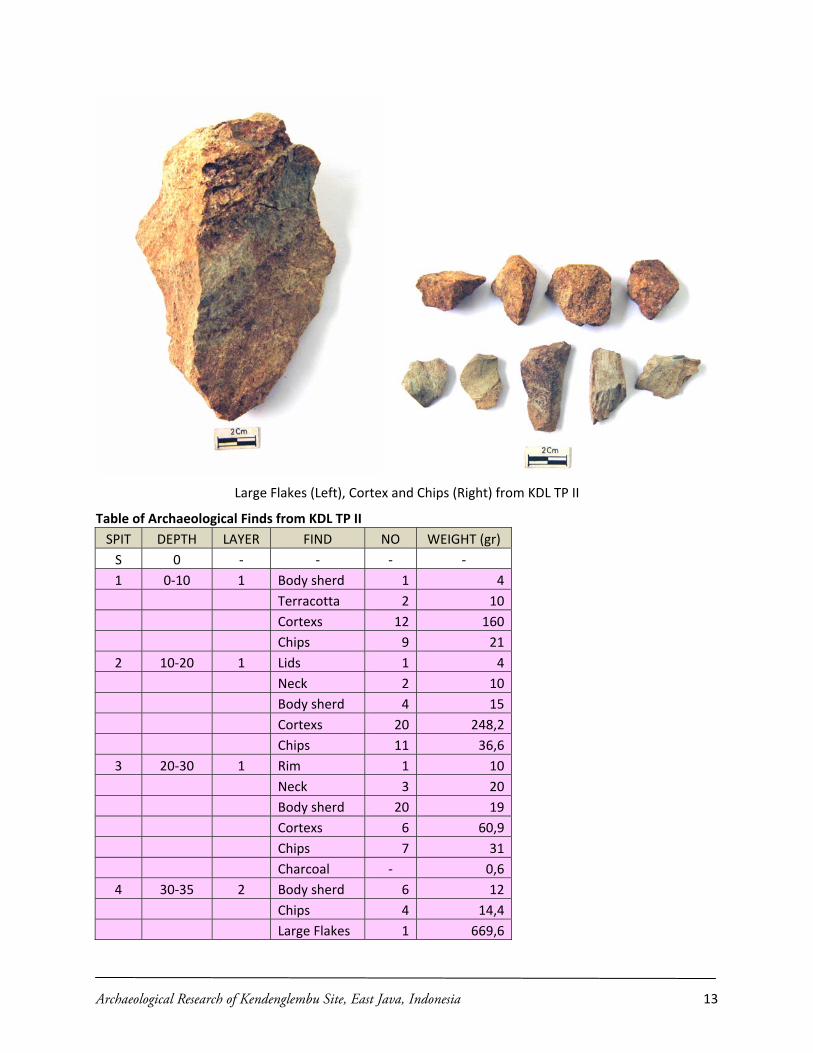
Archaeological Research of Kendenglembu Site, East Java, Indonesia 13
Large Flakes (Left), Cortex and Chips (Right) from KDL TP II
Table of Archaeological Finds from KDL TP II SPIT DEPTH LAYER FIND NO WEIGHT (gr) S 0 ‐ ‐ ‐ ‐ 1 0‐10 1 Bod y sherd 1 4
Terracotta 2 10Cortexs 12 160Chips 9 21
2 10‐20 1 Lids 1 4Neck 2 10Body sherd 4 15Cortexs 20 248,2Chips 11 36,6
3 20‐30 1 Rim 1 10Neck 3 20Body sherd 20 19Cortexs 6 60,9Chips 7 31Charcoal ‐ 0,6
4 30‐35 2 Body sherd 6 12Chips 4 14,4Large Flakes 1 669,6

Archaeological Research of Kendenglembu Site, East Java, Indonesia 14
5 35‐40 3 Terracotta 11 20Cortexs 10 115,1Chips 17 52,3Charcoal ‐ 1,5
6 40‐45 3 Body sherd 8 15Cortexs 5 55,4Chips 106 282,2Debris 78 41,7Blade 2 12,5Flakes 6 36,3Scraper 3 55,2Burin 2 2,6Charcoal ‐ 2,2
7 45‐50 3 Rim 1 10Body sherd 7 12Cortexs 1 10Chips 84 211,6Debris 42 25,4Flakes 3 49,7Charcoal ‐ 0,5
8 50‐55 4 Chips 21 119Debris 15 9,7Flakes 4 23,2Charcoal ‐ 2,5
9 55‐60 4 Cortexs 6 62,5Chips 4 15,7Debris 2Charcoal ‐ 2
10 Bedrock ‐ ‐ ‐ ‐ Info : The row with green s storic cultural layer ith yellow shadin Gap laye
is excavation box was still situated on the slope of Gunung Kambang Hill, in kendenglembu Hamlet. KDL TP III located
hading is HiThe row w g is r
The row with red shading is Neolithic cultural layer
c. KDL TP III
The KDL TP III located between TP I and TP II on a flat hill. Thflat of southern approximately 150 m north side of KDL TP I and 200 m east side of KDL TP II. This excavation box located on coordinate S 8° 21” 33.3’ E 114° 01” 19.0’ and altitude 195 m above sea level. KDL TP I was excavated to recover all culture layers in this location and to search datation sample. KDL TP II was excavated to 85 cm. The stratigraphy consist of five layers, from top to bottom are (1) reddish brown fine sand, (2) yellowish brown silt tuff, (3) dark brown silt clay, and (4) black brown clay. In this excavation box we found only historic cultural layer, without prehistoric (Neolithic) cultural layer.

Archaeological Research of Kendenglembu Site, East Java, Indonesia 15
Section of KDL TP III
KDL TP III was produces potsherds, terracotta and charcoal. We suggest all layers of lithology arerepresents as Historic cultural layer, bec historic (Neolithic) artifact found in this
ause there is not pre
excavation box. The potsherd shapes are; bowl, jar, vessel, and cooking pot. We suggest the archaeological nature indicating a historic habitation activity in this area (see the table bellows). The potteries color is red. These shapes are with foot and pointed carination. Technologically are produce by wheel made technique and indicated from Majapahit Kingdom era, similar with potteries from historic layer in KDL TP I.
Rim, Spout and Body Sherd of Majapahit Style from KDL TP III
Table of Archaeological Finds from KDL TP III SPIT DEPTH LAYER FIND NO WEIGHT (gr) S 0 ‐ Rim 1 5
Bod d 4y sher 2 281 0 ‐10 1 Lids 4 8
Body sherd 10 162 10‐20 1 Neck 2 12
Body sherd 1 6

Archaeological Research of Kendenglembu Site, East Java, Indonesia 16
Charcoal ‐ 0,83 20‐30 1 Neck 1 10
Body sherd 23 25Charcoal ‐ 3,7
4 30‐35 1 Rim 7 25Neck 3 15Body sherd 33 45
5 35‐40 1 Rim 9 20Neck 7 15Carination 3 15Terracotta 1 17,6
6 40‐45 1 Rim 5 35Spout 1 15Carination 2 30Body sherd 34 60Terracotta 2 40,3
7 45‐50 1 Rim 1 8Body sherd 18 25Foot sherd 2 12Charcoal ‐ 1,3
8 50‐55 2 Body sherd 2 20Terracotta 12 20,1Charcoal ‐ 0,7
9 55‐60 2 Terracotta 30 119,6Charcoal ‐ 1
10 60‐65 3 Terracotta 60 37,6Charcoal ‐ 1,6
11 65‐70 3 Terracotta 50 267,212 70‐75 3 Terracotta 35 18713 75‐80 3 Terracotta 22 117,514 80‐85 4 ‐ ‐ ‐
In : T with en s oric cul l layer T with low shadin is Gap layefo he row gre hading is Hist tura
he row yel g r The row with red shading is Neolithic cultural layer

Distribution Map of Excavation Box at Kendenglembu Site
Archaeological Research of Kendenglembu Site, East Java, Indonesia 17

d. RJS TP I
The TP I of Rejosari (RJS TP I) opened on the top of a hill near the border of Kendenglembu Estate and Treblasala Estate, located on Rejosari Hamlet. This excavation box located on coordinate S 8° 23” 09.7’ E 114° 00” 16.4’ and altitude 238 m above sea level. RJS TP I was excavated to explore all culture layers in this location based from information of previous research and to search datation sample of this excavation box. RJS TP I was excavated to 70 cm. The stratigraphy consist of five layers, from top to bottom are (1) reddish brown sandy clay, (2) dark brown clay, (3) bright yellowish brown tuff, and (4) dark black brown clay.
Section of RJS TP I
The reddish brown sandy clay layer in the top is recent layer. The dark brown clay and the dark black brown clay in the bottom are prehistoric (Neolithic) cultural layers, in the other hand the bright yellowish brown tuff in between indicated an influence of volcanic activity (probably Mount Raung, the nearest) in the middle period of site habitation (Neolithic phase). The recent layer produces chip, body sherd, fragment of iron and charcoal. We suggest about a few of prehistoric artifact which found at this layer originally come from prehistoric layer in the bottom, which is lift up caused by land preparation for rubber estate. The prehistoric layer produces cores, chips, cortex, debris, flakes, terracotta, body sherd, rim also neck of rep‐slipped pottery, and charcoal. Therefore, in RJS TP I we found only prehistoric layer, without historic layer. Based from archaeological nature, we suggest there is evidence of Neolithic settlement and workshop activity in this area.
Archaeological Research of Kendenglembu Site, East Java, Indonesia 18

Plank (Green‐grey Silicified Clay Stone) from Surface Find and Red Slipped Pottery from RJS TP I
Table of Archaeological Finds from RJS TP I SPIT DEPTH LAYER FIND NO WEIGHT (gr) NOTE S 0 ‐ ‐ ‐ ‐ 1 0‐10 1 Chips 1 52 10‐20 1 Body sherd 1 4
Iron 1 20Charcoal ‐ 4,8
3 20‐30 1 ‐ ‐ ‐ 4 30‐35 2 Core 1 190,3
Chips 5 42,45 35‐40 2 Terracotta 12 246 40‐45 2 Body sherd 8 15
Terracotta 20 40Debris 4 6Chips 10 49.4 1 Burned Charcoal ‐ 0,8
7 45‐50 2 Body sherd 30 40 Red‐Slipped Terracotta 16 32Cortex 4 104,4Chips 36 114 2 Burned
Archaeological Research of Kendenglembu Site, East Java, Indonesia 19

Debris 19 27,7 4 Burned Flakes 2 23 1 Burned Charcoal ‐ 6,4
8 50‐55 3 Rim 3 15Neck 2 10Body sherd 12 51Cortex 2 11,7Debris 5 20,5Chips 17 43,4 2 Burned Charcoal ‐ 7,7
9 55‐60 4 Rim 1 10Neck 1 8Body sherd 27 34 Red‐Slipped Core 1 173,6Chips 15 65 2 Burned
10 60‐65 4 Body sherd 18 20 Red‐Slipped Debris 5 8,8Chips 12 45,7 2 Burned Charcoal ‐ 7,6Core 1 95
11 65‐70 4 Core 1 59Chips 6 12Terracotta 3 6,7Charcoal ‐ 2,9 Sent to NSF Arizona
Info : The row with green shading is Historic cultural layer The row with yellow shading is Gap layer The row with red shading is Neolithic cultural layer
Archaeological Research of Kendenglembu Site, East Java, Indonesia 20

Location Map of Excavation Box at Rejosari Site
Discussion
From the excavation result, we found two main cultural layers at Kendenglembu sites, that is Neolithic (prehistoric) cultural layer and Historic cultural layer. The Neolithic cultural layer positioned vertically beneath the Historic cultural layer. Artifact produces from Neolithic layer reflect of habitation and workshop activity at Kendenglembu sites. We still wait for absolute chronological datation from this cultural layer. In the other hand, the artifact from Historic layer representing a historical village from Majapahit Kingdom period, approximately come from XIII ‐ XV AD. There is no evidence about historical continuity from Neolithic workshop and habitation until Majapahit period on those sites. Between of them, we found an indication about natural disaster caused by volcanic activity probably Mount Raung (the nearest).
Horizontally, we propose there is an indication about spatial arrangement by Neolithic people in Kendenglembu site. Artifacts which are produce from TP I KDL represented of habitation activity such as in a village. In the other hand, TP II KDL represented of workshop activity, where we found a lot of cortex, chips and debris of green‐grey silicified clay stone. The nearest location of raw material sources
Archaeological Research of Kendenglembu Site, East Java, Indonesia 21
for green‐grey silicified clay stone artifact located in the Sawojajar River at Kampung Anyar, it’s located about 3 Km north side of Kendenglembu site, not too far for catchment of Neolithic people (see Distribution Map of “Cluster of Kendenglembu Basin” Zone). We suggest the chunks of raw material obtained from Sawojajar River, and then they produce at the northwest side not far from their village. Perhaps, the workshop place is just occupy temporary times for produce of lithic tool only by craftsman, because there isn’t another artifact find in these place which indicated habitation activity. The craftsman of course lives in the village which located on a flat small hill southern slope of Kambang Hill. And it’s an indication about professionalism (special profession) in their social organization.
In Rejosari (Kalitajem, former name), we also found indication about Neolithic habitation and workshop activity. Different compare with Kendenglembu site, in Rejosari site there are two kind of raw material for produces stone artifact. They are green‐grey silicified clay stone and grey sand stone. Possibly, grey sand stone produce from Gunung Lembu, near Sukobumi Hamlet about 6 Km east side of Rejosari site. In the other hand, from Rejosari site to Kampung Anyar which produces green‐grey silicified clay stone take 7 Km to the north. In surface survey at Sukobumi Kampung Site, we found another of raw material for lithic tools, which is made from brown silicified clay stone. And we also found the query of this raw material which located near Seneposari sites, about 12 Km south side of Sikobumi Kampung site in Cluster of Coastal Area. We suggest there is an interaction between Neolithic people inland and the people in coastal land, by the Kalibaru River.
We collect three samples dating from Neolithic layer of Kendenglembu, Historic layer of Kendenglembu and Neolithic layer of Rejosari for reconstruct the cultural chronology of those sites habitation. Neolithic sample dating of Kendenglembu produce by KDL TP I layer 4 spit (11), in the other hand Historic sample dating of Kendenglembu produce by layer 2 spit (6) from same excavation box. Neolithic sample dating of Rejosari comes from RJS TP I layer 4 spit (11). We consider KDL TP I is still have original stratigraphy layer and yield same archaeological character with previous research, therefore we collect sample dating from the most significance lower level of Neolithic cultural layer and Historical cultural layer of these excavation box. For comparison needed, we also collect sample dating from the lower level of Neolithic cultural layer RJS TP I. We send those samples to Greg Hodgins at the University of Arizona, USA and the dating will be finished in the late of January 2009. Moreover we collect sediment sample from every stratigraphy layer of all excavation box. Sediment analysis of Starch and Phytolith from KDL TP I is doing by Dr. Mahirta from Gadjah Mada University, Yogyakarta, for answer the question about early millet agriculture in Java. The analysis is in sample preparation progress and will be finished in the late of January 2009.
Austronesian Colonization in Kendenglembu Site
Where did they come from? From linguistic evidence, (see Blust, 1985) proposed that there are Javanese language sub‐group comes from Southeast Kalimantan at downstream of Barito River approx. in 1000‐1500 BC. That separated process of those people was took place around 800‐1000 BC. In Banyuwangi region, there are a local people called Osing people which similar with Banyumas people in west part of Central Java. Osing and Banyumasan language are a type of recent Javanese language which has closed connection with Old Javanese language from linguistic perspective. But, the correlation of Osing people, Banyumas people, Old Javanese people and Austronesian people in Kuala Barito still not clear. The nearest place from Southeast Kalimantan is northern coast of Java and Madura Island. Austronesian people cannot pass north coast of Java to reach Kendenglembu, because of natural barrier there is volcanic arc (Mount Raung). They must turn right around from Java sea via Bali strait and then landing at downstream of Kali Baru River at eastern south coast of Java. Perhaps in this time several early Neolithic sites in northern coast of Java positioned bellow alluvial deposit, because of these condition it’s difficult to found and to investigate it (Bellwood, 2000). The other probability, maybe there
Archaeological Research of Kendenglembu Site, East Java, Indonesia 22

is no direct Austronesian migration come from southeast Kalimantan into north coast Java, because it is a complicated process. Austronesian people colonized interior Java by “string of pearl model”, from coastal area of Indian Ocean until Kendenglembu Basin through along Kali Baru River. This case was similar to Austronesian colonization of West Sulawesi through Karama River, from Tasiu, Sikendeng and Lattibung at coastal area until Minanga Sipakko, Kamassi and Tambing‐tambing at upper course (see Simanjuntak, 2006).
Why they choose to colonize Kendenglembu and several locations near Kali Baru River Basin? From geographic perspective (Sunarto, 1987), Kendenglembu site located on a little hill with extreme low relief type (5 m), slope modus of gently sloping (6%‐12%), near of water sources (river, seepage and spring) which always flow in dry season and abundant location of raw material sources. Landform of site is fluvio‐volcanic fan by characteristic of volcanic lithology especially lava and tuff material with high porosity and permeability, also stable and fertile. Based from these geographic conditions, Kendenglembu and Kali Baru River Basin are a strategic and comfortable place for human occupation and for developing agriculture.
Landscape of Kendenglembu Basin, with Merawan Mountain Surroundings
Where did they move furthermore? Several possibilities are; when Austronesian people try to sail periphery of Indian Ocean, maybe they will also effort to explore coastal land along southern Java Island and Lesser Sunda Islands. Based from typology study, the pick adze made from green‐grey silicified clay stone of Kendenglembu has same type and raw material with a pick adze from Nusa Penida Island (South of Bali), and the chisel made from grey sand stone is same with Klusu (Bali). All those artifacts from Bali are collected by R.P. Soejono in 1962 ‐ 1963, and now kept in Museum Gedong Arca (Office of Archaeological Heritage Conservation), Gianyar. In Java, a lot of habitation sites comes from later phase (proto‐historic period, 2000 BP) have explored by Nitihaminoto. They found along southern coast of Java starting by Jatiagung and Panggulmlati (Jember) in the east, Meleman and Tempursari (Lumajang), Panggul (Trenggalek), Krakal (Gunung Kidul), Gunungwingko (Bantul), Wingkosigromulyo (Purworejo, until Ayamputih (Kebumen) in the west (Nitihaminoto, 2004). But, we do not know yet the correlation of Neolithic sites in Banyuwangi compare with the Neolithic sites in Southern Bali and post Neolithic sites in southern coast of Java. Then, when Austronesian people already to sail across open ocean, maybe they will sail across Indian Ocean into several island on the Indian Ocean, such as; Christmas Island, Northern Territory of Australia, etc until eastern coast of Africa and Madagascar. It is a long journey, to test these hypotheses are need an intensive and comprehensive inter regional research on the future.
Implication
Based from significance result of this research, we would to continue of the research at Kendenglembu and its surrounding area. Systematic excavation should conduct at new discovered sites which very closed and in danger by development of southern alternative road of Java, such as Pagergunung site and Treblasala‐Rejosari 1 site. Surface survey activities still require to covers all Neolithic site lateral distribution along Kali Baru River. The further survey should conduct on the river fork of Kali Baru River, such as; Kali Tengah River, Kali Lele River, Kali Senepo River and another old river near Kali Baru River, such as Lembu River dan Karangtambak River.
Archaeological Research of Kendenglembu Site, East Java, Indonesia 23

Archaeological Research of Kendenglembu Site, East Java, Indonesia 24
Acknowledgements
Grateful thanks are directed to Anthony F. Granucci who provided the funding for conducting excavation work at Kendenglembu, and to Peter Bellwood with IPPA for organizing the funding. Special thanks must go to Drs. Siswanto the Head of Balai Arkeologi Yogyakarta, and Ir. Yusmartin the Administrator of PTPN XII Kendenglembu, for giving the support and aid to conduct this research. Thanks also to Priyatno HS (archaeologist), Tedy Setiadi (technician of drawing and mapping), Slamet Widodo (technician of finds treatment), and Didik Santoso (Driver) of Balai Arkeologi Yogyakarta. Mahirta of Gadjah Mada University did pollen identifications and phytolith analysis. Agus Trihascaryo of Gadjah Mada University provided information about geographic and environment condition. To the local assistance, especially Suloso, Andri, Haryadi, Hartono, Prayogo, and Supri.
Reference
Bellwood, Peter 2000 Prasejarah Kepulauan Indo‐Malaysia, Edisi revisi, Jakarta: PT. Gramedia Pustaka
Utama.
2006 “The Early Movement of Austronesian‐speaking‐peoples in the Indonesian Region”, dalam Truman Simanjuntak, dkk. ed, Austronesian Diaspora and the Ethnogeneses of People in Indonesian Archipelago, Jakarta: LIPI Press. hlm. 61‐82.
Blust, Robert 1984/1985 “The Austronesian Homeland: A Lingustic Perspective”, Asian Perspectives No. 26 (1),
pp. 45‐68. Heekeren, H.R. van 1972 “The Stone Age of Indonesia”, Verhandelingen van het Koninklijk Instituut voor Tall‐,
Land‐, en Volkenkunde, 61, Revised Edition, The Hague: Martinus Nijhoff Nitihaminoto, Goenadi 2004 “Desa‐desa Kuno Pantai Selatan Jawa”, Berkala Arkeologi Tahun XXIV Edisi No.1/Mei,
Yogyakarta: Balai Arkeologi Simanjuntak, Truman 2001 Gunung Sewu in Prehistoric Times, Yogyakarta: Gadjah Mada University Press. 2006 “Advance of Research on the Austronesian in Sulawesi”, Truman Simanjuntak, dkk. ed,
Austronesian Diaspora and the Ethnogeneses of People in Indonesian Archipelago, Jakarta: LIPI Press. pp. 223‐231.
Soejono, R.P 1984 Sejarah Nasional Indonesia I, Jakarta: Balai Pustaka Sunarto 1987 Penelitian Geomorfolgi pada Situs Arkeologi Kendenglembu, Jawa Timur, Yogyakarta:
Fakultas Geografi, Universitas Gadjah Mada Tanudirjo, Daud Aris 2006 ”The Dispersal of Austronesian‐speaking‐people and the Ethnogenesis Indonesian
People” dalam Truman Simanjuntak, dkk. ed, Austronesian Diaspora and the Ethnogeneses of People in Indonesian Archipelago, Jakarta: LIPI Press. pp. 83 ‐ 98.
Tim Ekskavasi 1986/1987 Laporan Kerja Ekskavasi Kendenglembu II, Yogyakarta: Balai Arkeologi Yogyakarta