archaeology—lost civilizations: the … ayaga, debbie brooks, julie eubank, kelsie frank, vani...
TRANSCRIPT

ARCHAEOLOGY—LOST CIVILIZATIONS: THE PUZZLE OF THE MANTENO-HUANCAVILCA
Odie Ayaga, Debbie Brooks, Julie Eubank, Kelsie Frank, Vani Kilakkathi, John Lee, Christine
Marshall, Laurel Pellegrino, Jayme Ranalli, Sharmin Shahnaz, Yu-Ann Wang
Advisor: Dr. Maria Masucci Teaching Assistant: Jean Barmash
ABSTRACT
The ancient culture of the Manteño people of Ecuador has been lost over time. Very little is known about them beyond their name, which was recorded by the Spanish conquistadores in the 16th century. Five soil samples were excavated from a site in Ecuador that was believed to have been an important trading center for the Manteño people. The goal of our team project was to discover the lost culture of the Manteño people by analyzing these soil samples and identifying microscopic remains preserved in the soils. Because there were virtually no visible artifacts at the site, light and scanning electron microscopes were used to detect and identify micro-artifacts hidden in the soil samples. Items such as ceramics and shells that were discovered in the samples helped us to interpret the function of the site and its meaning for the Manteño people.
INTRODUCTION
Lost in the annals of history and hidden among the sands of time there existed a people, largely ignored from historical records. According to what we know about them from Spanish explorers, the Manteño-Huancavilca inhabited coastal Ecuador and established a trading empire that flourished from about 700 to 1542 AD. One of their settlements near modern-day Chanduy was virtually destroyed when treasure hunters desecrated a nearby cemetery, and it was up to us to piece together the shattered remains of their existence. Through our analysis of micro-artifacts found on platforms that were originally thought to be religious pyramids, it was our hope to discover how the Manteño-Huancavilca lived and how their numerous platforms were actually used. Literally, we sifted through the sands of time to search for a past that was lost long ago.
Led by Dr. Maria Masucci, we discovered what archaeology is and how archaeologists piece
together information to learn about ancient cultures. Archaeology is the study of human past through the discovery and analysis of artifacts or remains that have been left behind and preserved. Artifacts include objects used, made, or modified by people, as well as organic and environmental remains such as seeds and animal bones. Archaeologists are trained to systematically excavate a site and recover artifacts from the soil. They must be able to map out where every artifact is found and record its context. They take soil samples proportional to the size of the area, being careful not to damage the excavation site. They then analyze the soil further in the lab. When analyzing the soil, using scientific instruments like light microscopes, they are trained to identify small artifacts. After collecting the data, archaeologists must come up with a hypothesis that explains how everything fits together and how the people that they are studying lived.
[4-1]

Archaeometry is a specific branch of archaeology that applies science and scientific tools to
archaeology. The scientific method provides archaeologists with an organized way to approach their work using a question, hypothesis, results, and analysis. Scientific tools such as light microscopes and scanning electron microscopes are used to analyze soil samples. With these scientific tools, a whole new set of clues is opened up to archaeologists because microscopic artifacts can be examined in addition to macroscopic ones. Background and Orientation
The tribe of the Manteño-Huancavilca
lived along the coast of Ecuador from 700/900 AD until 1542 AD, when they were conquered by Francisco Pizzaro and his Spanish expedition. They were a prominent local culture, which even the all-powerful Incas could not conquer. Their territory was located along the coast of Ecuador from north of the Bahia de Caraquez down to the island of Puna and inland over Cerro de Hojas and the hills of southern Manabi (Fig. 1). The tribe is referred to as the Manteño, the Huancavilca, or the Manteño -Huancavilca. This leads archaeologists to believe that the Manteño conquered and absorbed the Huancavilca into their culture by economic means [1].
According to Spanish documents, the Manteño pro
textiles and shell beads. The people used rafts made of sails to transport their trade goods as far North as Mexiregion is a fertile one that supported the growth of maizManteño people would have relied on ceramics for condaily tasks including cutting, food preparation, and prosurvive, they would have cooked over fires leaving beharchaeological record. Organic materials such as textileusually preserve unless they were charred, but ceramicthousands of years providing a testimony to the ancient
The Spanish stopped in three places in Ecuador, on
city, there is believed to have been an important tradingtoday believe they have found this port, which they calLittle Crabs.” It was given this name by previous archgold in the nearby cemetery. After these treasure-huntiarchaeologists moved in, searching for a link to the pasHuancavilca [1, 2].
[4-2]
Figure 1: Map of Ecuador [3]
duced and traded great quantities of balsa logs with wooden masts and cotton co and as far South as Peru. The coastal e, yucca, beans, and squash. The tainers and manufactured stone tools for duction of shell ornaments. In order to ind traces or artifacts in the s, baskets, and food remains do not
s, stone, and shell can survive for culture [1, 2].
e of which was Chanduy. Near this large port for the Manteño. Archaeologists
l Loma de los Cangrejetos, or “Hill of the aeologists who were mostly searching for ng gravediggers left, teams of professional t and the history of the Manteño-

The archaeologists discovered raised earth platforms, which were possibly used for ceremonial or trading purposes. An archaeology team from Drew University excavated two of these platforms but found few artifacts to help identify the meaning and use of the platforms. It is possible that the platforms may have been thoroughly swept and cleaned. Based on the assumption that no amount of cleaning can remove all remains, soil samples from the platforms were collected. We examined the soil samples for small and even microscopic artifacts such as shells, bone, and ceramic, which could give us valuable clues to how the ancient site was used.
Overview of the Excavation Site
The site from which our samples came is divided into three primary areas (Fig. 2): a
paboMare ofdahawharccoplawe
cemetery, a section filled with trash, and a portion with four artificial platforms which we now know are underlain by a layer of ancient trash. The first region, the cemetery, was in use from 1100 AD to when the Spanish arrived in 1542. It is located approximately 100m to the northeast of the area with earth platforms. Unfortunately, it was looted in the mid-20th century and now lacks any artifacts that would be helpful in investigating the site. Originally, each grave contained not only the remains of a Manteño native, but many treasures and relics from his or her lifetime. The amount of gold and rich artifacts in the grave suggests that these were likely the graves of Manteño chiefs or wealthy members of the tribe.
Figure 2: Elevation map of the Site
The second area is a section that contains many layers of what appears to be garbage. In this
rt, excavators found items similar to those that we found in one of our samples, including nes of fish and small reptiles, ceramics, shells, and charred wood. It does not look like the anteño ever actually lived in this part of the site, but possibly used it as a dump. The actual a of the settlement at that time was near the dump.
Our samples came from the layers below two of the human-made platforms at the third area the site. The bottom layer, labeled as matrix six, is presumed to be the oldest; radiocarbon ting approximates the last time it was used to be about 700-900 AD. This layer is thought to ve been used as a place for trash disposal. It contains a multitude of micro-artifacts, much of ich we expected, including charred wood, bones, ceramic fragments, and shell. The haeologist Dr. Jorge Marcos excavated the site in the 1960s and found proof of what he
ncluded to be ceremonial rituals. His team found a whole duck and a necklace on one of the tforms, convincing them that the platforms were used for ceremonies of some kind. However, did not find any direct evidence corroborating his conclusions [3].
[4-3]

TOOLS OF ARCHEOLOGY Carbon Dating Used to Identify Age of Artifacts
In archaeology it is important to accurately identify the age of artifacts. A method called
radiocarbon dating allows scientists to date artifacts that have been formed between 500 and 50,000 years ago. All living things contain carbon from atmospheric carbon dioxide. Carbon exists in both stable and radioactive forms. When an atom of Nitrogen-14 in the upper atmosphere is hit by a cosmic ray, radioactive Carbon is formed. Carbon-14 enters the earth's organic matter through photosynthesis and the food chain. When animals and plants are living, the Carbon contained within the organisms is in equilibrium with Carbon in the atmosphere, but when the organism dies the Carbon intake stops and decay occurs. Radioactive Carbon decays into a stable state at a known rate, called the half-life. The half-life of Carbon-14 is 5,568 years. In order to determine the age of an organic artifact, one needs to know the original ratio between stable and radioactive Carbon, as well as the rate at which Carbon decays. By measuring the remaining radioactive Carbon the amount of time passed since the animal or plant was alive can be determined. This method is particularly useful for dating wood charcoal [4, 5]. Poppy Seed Technique to Determine Recovery Rate
Poppy seeds were an important tool in our search for micro-artifacts. They were used as a control and allowed us to estimate the accuracy of our recovery of remains. We used poppy seeds in our investigation because there is no chance of finding an archaeological poppy seed in a sample from Ecuador. We put a fixed number of seeds in a sample (depending on the size of the soil sample) and then picked them out as we were looking for artifacts. The number of seeds recovered from each bag was used to determine the recovery rate, an indication of how accurately we examined the samples.
Hydrochloric Acid Test
Hydrochloric acid was used to test for calcium carbonate in the soil samples. Archaeologists
believe that the Manteño’s used this material to create hard floors for their living space. Calcium carbonate is not naturally found in the soil we examined, so its presence in our samples would support this hypothesis. The equation of hydrogen chloride and calcium carbonate is: HCl + CaCO3 → CaCl2 + CO2 + H2O. When hydrochloric acid is added to a sample that contains calcium carbonate, carbon dioxide is released and gives the soil a fizzing effect. We first added hydrochloric acid to pure calcium carbonate and noted the reaction. This acted as our control because the fizzing of the other samples could be compared to the fizzing in the pure calcium carbonate [6]. The Use of a Scanning Electron Microscope
Regular light microscopes are sometimes inadequate in correctly identifying and examining
micro-artifacts. In these instances, the Scanning Electron Microscope (SEM) is used because it can examine objects at a much higher magnification and resolution. Its range of magnification is
[4-4]

between about 37x and 200,000x with a resolution of five nanometers. Many scientists, in a variety of fields, use the SEM, and it is one of the most advanced tools in modern science [7].
The SEM uses electron waves, which have a much
shorter wavelength than regular light waves. At the top of an SEM, an electron gun shoots out an electron beam (Fig. 3 below). This beam passes through an anode, a condenser, and an objective lens, which respectively attracts, condenses, and then focuses the beam. Scan coils inside the objective lens make the electrons bounce back and forth and scan the specimen. Secondary electrons (electrons which have inelastic collisions with the specimen) come off the specimen after it is hit by the beam of electrons. A detector sends signals of these electrons to an amplifier, which produces a final image of light and dark areas. Basically, the more secondary electrons there are, the lighter thBecause electrons collide with air molecules and do not travel microscope. This can create a problem when something liquidwith mostly dry objects in this project [7].
METHODOLOGY The Division of the Excavation Site
Two platforms at the main site of Loma de los Cangrejitosyears by a team of archaeologists from Drew University. This of soil underneath the platforms. Each layer, known as a matriactivities over a large span of time. A matrix is composed of ththat is found naturally in the environs such as clay, gravel, musite is also subjected to natural processes such as insect and plaerosion. Therefore, the matrix at any archaeological site has repossible origins including the result of cultural, chemical, and have a particular interest in the human-made strata, where therbehind by the ancient cultures.
During the excavation of a site, archaeologists use codes to
artifacts that are found at a site or in a matrix. This code, or labsample, is called the provenience of the sample. For example, MV-C2-4f-5. This tells the general area, the location within thwithin that section, and finally the matrix level under the soil. archaeologists because they provide information as to the locaartifacts, which can be used to determine the significance of a
At the site in Ecuador a grid and a map were used to track every sample and find. When digging, excavators work in onecontrol and label the layers based on composition for vertical c
[4-5]
at part as far, a needs t
were exteam unx or strae mater
d, or sannt biotu
sulted fphysicae may b
keep trel for t
one of oat area, Provenition of esample.
the prov by one ontrol.
Figure 3: SEM [8]
of the image will be. vacuum is needed in the
o examined, but we dealt
cavated over the past three covered a series of layers ta, was created by human ial or physical substance d. Over time the strata at a rbation or disturbance and
rom any number of l activity. Archaeologists e micro-artifacts left
ack of samples and he location or origin of a ur samples was labeled the square meter block ence codes help xtracted samples and
enience or location of meter blocks for horizontal For example, a well-

defined horizontal layer of compact white soil, which was believed to be human-made, was assigned the label matrix five. From one of the mounds, a trench was excavated which was a strip of earth six meters long by one meter wide divided into six one-square meter sections labeled B1 through B6. These small sections make it possible for archaeologists to keep track of exactly where samples and artifacts were found so that relationships between different areas of the site can be established. Subdividing the Work
Layers four, five and six from two of the platforms at the excavation site were examined by our team. Early in our research, the team was divided into three groups of three to four people, and each group was provided with soil samples from a certain layer of the excavation site. Two groups in the class were assigned soil samples from the B2 section of this strip, and they were responsible for the fourth and fifth layers of earth under the ground and the third group for the deepest, or sixth layer. Layer six was much thicker and more undulating than the other two layers studied. Different sized soil samples were taken from each matrix in proportion to the volume of the layer at the site. The provenience and strata number of each area were recorded, along with the thickness of the layers, their placement below the ground, the color and consistency of the layer, and the topography of the upper and lower limits. This information was kept track of at all times so that the samples were analyzed in context and no remains were mixed. Methods Used to Analyze the Sample
Once we investigated the context of each sample, we began to dry sift the materials. Hubbard sieves were used to divide a sample of soil into size fractions. We analyzed our samples using the U.S. standard sieves of size #5 (sieve opening: 4.0 mm; traps gravel and fine pebbles), #10 (sieve opening: 2 mm; traps fine gravel and very coarse sand), #60 (sieve opening: 250 um; traps fine sand), and the bottom pan (sieve opening less than 45 um; traps silt and clay). This size breakdown makes it easier for scientists to focus on uniform size particles under a microscope and therefore allows for higher recovery rates of artifacts. After separating the samples according to size, we placed each size sample in a separate bag, and worked on each layer and size fraction separately. We placed a small amount of soil from each bag into Petri dishes, and we analyzed them under the light microscopes, working systematically from one end of the dish to the other. This was a slow and tedious process. Gradually, our eyes became trained to distinguish artifacts from natural occurring materials such as dirt and rocks. When materials that we found were too small to see and identify in detail using the light microscope we used the Scanning Electron Microscope. Methods Adapted Along the Way
During our project, we had to adapt methods to solve problems unforeseen at the beginning of our work. One such method was Experimental Archaeology. This is the creation of controlled observational data that is used in comparison with actual archaeological materials to aid with identification. The material we worked with was very small and fragmentary making it was hard to confidently distinguish artifacts from natural pieces of rock and shell. First, we performed “eye training” exercises. We looked at known substances such as charred cotton seeds to see
[4-6]
what they would look like under the microscope. We also broke off pieces of ceramic and rock and noted what they looked like under the microscope, so that we could recognize them when we saw them in our sample. Also, we used type samples, or pieces of known objects, under the scanning electron microscope and viewed them in comparison to archaeological finds. This process was used in identifying shell, seeds, obsidian, and shells (Appendix I).
Another method we employed during our research was dissolving the material of matrix five
to see if there was anything embedded in the calcified material of this matrix. We took large and small pieces of dried up medium, placed them in water, swirled this mixture around to see if there were any ceramic or shell fragments inside the calcified pieces. We then strained the dissolved dirt and water away, leaving behind clean artifacts. However, this method did not yield much additional data and therefore we feel confident there are very few artifacts in this layer. EXPERIMENTAL RESULTS Soil Type, Matrices, and Micro-Artifacts Recovered
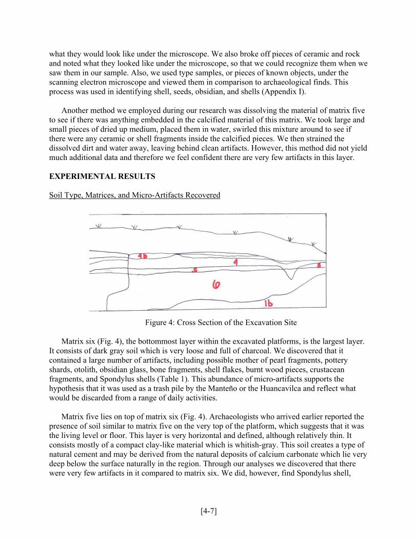
Figure 4: Cross Section of the Excavation Site
Matrix six (Fig. 4), the bottommost layer within the excavated platforms, is the largest layer.
It consists of dark gray soil which is very loose and full of charcoal. We discovered that it contained a large number of artifacts, including possible mother of pearl fragments, pottery shards, otolith, obsidian glass, bone fragments, shell flakes, burnt wood pieces, crustacean fragments, and Spondylus shells (Table 1). This abundance of micro-artifacts supports the hypothesis that it was used as a trash pile by the Manteño or the Huancavilca and reflect what would be discarded from a range of daily activities.
Matrix five lies on top of matrix six (Fig. 4). Archaeologists who arrived earlier reported the presence of soil similar to matrix five on the very top of the platform, which suggests that it was the living level or floor. This layer is very horizontal and defined, although relatively thin. It consists mostly of a compact clay-like material which is whitish-gray. This soil creates a type of natural cement and may be derived from the natural deposits of calcium carbonate which lie very deep below the surface naturally in the region. Through our analyses we discovered that there were very few artifacts in it compared to matrix six. We did, however, find Spondylus shell,
[4-7]
obsidian, and a large amount of wood charcoal (Table 1). Many smoothed off fragments of the compact white clay were also found, which could have been the outside layer of bricks or floor.
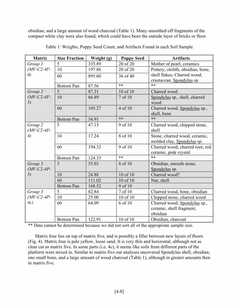
Table 1: Weights, Poppy Seed Count, and Artifacts Found in each Soil Sample
Matrix Size Fraction Weight (g) Poppy Seed Artifacts 5 335.89 20 of 20 Mother of pearl, ceramics 10 197.86 20 of 20 60 895.60 36 of 40
Pottery, otolith, obsidian, bone, shell flakes, Charred wood, crustacean, Spondylus sp.
Group 1 (MV-C2-4F-6)
Bottom Pan 87.56 ** ** 5 87.31 10 of 10 Charred wood 10 66.89 7 of 10 Spondylus sp., shell, charred
wood 60 105.27 4 of 10 Charred wood, Spondylus sp.,
shell, bone
Group 2 (MV-C2-4F-5)
Bottom Pan 54.91 ** ** 5 47.15 9 of 10 Charred wood, chipped stone,
shell 10 17.24 8 of 10 Stone, charred wood, ceramic,
molded clay, Spondylus sp. 60 194.32 9 of 10 Charred wood, charred root, red
ceramic, pink crystal
Group 2 (MV-C2-4F-4)
Bottom Pan 124.33 ** ** 5 55.03 8 of 10 Obsidian, smooth stone,
Spondylus sp. 10 24.88 10 of 10 Charred wood? 60 111.02 10 of 10 Nut, shell
Group 3 (MV-C2-4P-5)
Bottom Pan 168.52 9 of 10 5 82.84 7 of 10 Charred wood, bone, obsidian 10 25.00 10 of 10 Chipped stone, charred wood 60 64.09 6 of 10 Charred wood, Spondylus sp.,
ceramic, shell fragment, obsidian
Group 3 (MV-C2-4P-4c)
Bottom Pan 122.91 10 of 10 Obsidian, charcoal ** Data cannot be determined because we did not sort all of the appropriate sample size.
Matrix four lies on top of matrix five, and is possibly a filler between new layers of floors
(Fig. 4). Matrix four is pale yellow, loose sand. It is very thin and horizontal, although not as clear cut as matrix five. In some parts (i.e. 4c), it seems like soils from different parts of the platform were mixed in. Similar to matrix five our analyses uncovered Spondylus shell, obsidian, one small bone, and a large amount of wood charcoal (Table 1), although in greater amounts then in matrix five.
[4-8]

Table 2 illustrates the total weight and sorted weight calculated from Table 1. It also shows the total recovery rates for each sample. Samples where the poppy seeds blended in easily had lower recovery rates. Also, recovery rates differed with the speed with which the samples were examined. Towards the end of the project, we had to go through our sample at slightly quicker pace and lost some accuracy.
Table 2: Total Weights and Recovery Rates for Each Matrix
Matrix Total Weight (g) Sorted Weight (g) Recovery Rate MV-C2-4F-6 1516.91 536.07 82.9 % MV-C2-4F-5 314.38 259.47 70.0 % MV-C2-4F-4 383.04 258.71 86.7 % MV-C2-4P-5 353.73 353.73 92.5 % MV-C2-4P-4c 294.84 294.84 82.5 %
Size Fraction Distribution Graphs Figure 5 illustrates the naturally occurring distributions of various size fractions of a sample based on the environment from which it came. The shapes of the figures reflect the mode of transportation that is prominent in each natural environment. The force and velocity of various modes of transport determines the amount of particles of each weight and size. For example, in an environment such as a river channel where water (a relatively powerful force) is the primary mode of transport, there is likely to be more heavy particles than in loess, where wind (a much weaker moving force) moves mainly sand and silt. This is illustrated in the chart by the figures: in the river channel shape, the widest parts are in sand and “gvl” (gravel), but in the loess diagram, the widest part is centered in the silt area.
Figure 5: Naturally Occurring Environments [9] Figure 6 was calculated using the weight of each size of particle and the total weight of the
sample to calculate the percentage composition of each size. The figure was then drawn in proper proportion to reflect the relative percentages. These percentages were calculated for each of the matrices from the samples from Ecuador.
[4-9]

Figure 6: Size Fraction Distribution Graphs for the Site in Chanduy, Ecuador Archaeologists use this type of chart to aid in identifying the type of environments that existed sometimes millions of years ago. For example, a region that may presently be desert could have possibly been swampland in the past. Archaeologists excavate underlying strata and compare their own size fraction distribution graphs to existing charts to get an idea of what the land could have been like. These graphs are important concerning the samples from the Manteño site because the figures do not reflect any similarity to those on the control chart. This shows that the layers of soil that make up the strata below the platforms were in fact human-altered rather than naturally-occurring. The hourglass shape of the distribution of all five of the Ecuadorian samples is not a typical natural phenomenon, further emphasizing that humans had some influence on the way the layers are composed. Carbon Dating Results
Carbon dating is a method used by scientists to identify the age of artifacts based on the amount of radioactive carbon in the sample. Scientists used carbon dating on materials from our excavation site and found that matrix six, the bottom matrix, was formed around 700-900 AD [10]. According to the Law of Stratographic Relationships, which states that as long as there are no visible signs of disturbance, deeper layers will be older than layers closer to the surface, we know that matrices four and five must be newer because they are located on top of matrix six. The cemetery to the northeast of our site dates to 1100-1542 AD, making it more recent than the trash piles located in matrix six but possibly dating to the same time as matrix four and five [10]. Hydrochloric Acid Test Results
Table 3: Results from the Hydrochloric Acid Test
Matrix Result Matrix Result Group 1 (MV-C2-4F-6)
Reacted in all areas Group 3(MV-C2-4P-5)
Reacted in all areas
Group 2(MV-C2-4F-5)
Reacted in all areas Group 3(MV-C2-4P-4c)
Reacted in all areas
Group 2(MV-C2-4F-4)
Reacted in spots
[4-10]

The hydrochloric acid test revealed an abundance of calcium carbonate in matrix 5 (Table 3).
This confirmed our hypothesis that matrix 5 was made of hardened calcium carbonate dug up by the Manteños. Calcium carbonate found in this matrix could not be natural because they are usually found in deeper deposits derived from old sea floors. The hydrochloric acid tests revealed traces of calcium carbonate in the other matrices because calcium carbonate can also be found in sea shells and there was probably some mixing between layers.
Possible Error
There are many possible problems that make micro-archaeology a difficult and tedious science. It is easy to mistake modern remains for archaeological artifacts. Shells are naturally occurring, and some types of shell found are not necessarily archaeological. The existence of some items in our sample does not mean that they got there through Manteño use. Small “artifacts,” especially things that we may have found only one of, could have been blown in there or artificially transported there by the Drew University team or others.
Additionally, the micro-artifacts in our sample are so fragmentary and small that they are sometimes very difficult to properly identify. Bones and shells are two artifacts that we can only identify generally; it is very difficult to determine what species of animal or shell from which they came from. We used poppy seeds to determine our recovery rate. However, even a high recovery rate does not guarantee the retrieval of all important remains, because it is still possible to miss microscopic and unidentifiable artifacts. One significant problem may have been that we have no previous experience in micro-archaeology and therefore found it difficult to differentiate between worthless pieces of soil or rock and artifacts that may have provided us with vital information as to how the Manteño lived. ANALYSIS The earth platforms excavated at Loma de los Cangrejitos in Ecuador consist of several strata or layers of soil. Each layer is labeled as a specific matrix. Matrix six is the oldest, on the bottom and matrix one, the most modern, on the surface. The matrices explain different eras in the history of the Manteño-Huancavilca. Our team examined samples from matrix six and the two levels above it, matrices five and four. Matrix Six The lowest level, matrix six, lies 97 cm below ground level. We recovered a wide variety of items that suggest that this level may have been a site for the disposal of domestic waste. The recovery of animal bones, cut shells, wood charcoal, ceramic fragments and chipped stone fragments suggest that the Manteño or the local Huancavilca were involved in domestic activities such as food preparation and consumption, stone tool making, shell ornament manufacture, and wood fire cooking.
[4-11]

From the characteristics of the wide range of artifacts discovered in matrix six, we determined some of the fragments to be human-made. For example, we found obsidian flakes in our samples (Fig. 7). These fragments could be identified as human-made by looking at the conchoidal fractures and sharp edges of the stone which do not occur naturally. These characteristics result from sharp blows or flaking of the obsidian for the purpose of making tools. Another recovered artifact was small pieces of pink and purple shell identified as the Spondylus species (Fig. 8), reported by the Spanish conquerors to be highly valued by the local tribes. Traditionally, the valued, colored rim was used to manufacture beads and as a currency. Because these shells are only found on the ocean floor, trained divers probably gathered these rare prizes for the purpose of creating beads. The theory that bead-making was carried out at this site is supported by the finding of a sharp, unfinished, chipped stone (Fig. 9), most likely a small drill bit used for boring holes through the tiny shell pieces. The fact that the drill bit was unfinished suggests that tools may have been constructed at the site as well.
igure 7: SEM Image of an Obsidian Flake
Ceramic pieces were also unearthed (Fig. 10), suggesting that food preparation and consumption occurred there. One specific ceramic piece, found in size fraction number five of matrix six, was decorated with ochre-red designs. The most abundant artifact was charred wood (Fig. 11). These findings suggest that the activities at the site included cooking. Other findings in matrix six were not human-altered, but because they are not naturally occurring in these layers, they have relevance as to how the Manteño lived. These items
Figure 11: Light Microscope Image of Charred Wood
Fi
[4-12]
F
Figure 8: Light Microscope Image of Spondylus sp.
Figure 9: SEM Image of Chipped Stone
gure 12: Light Microscope Image of a Lizard Bone
Figure 10: SEM Imageof a Ceramic Piece

included lizard bones (Fig. 12), crustacean remains (Fig. 13), and an otolith (Fig. 14), one of the small bones in the inner ear of fish, suggesting that the diet of these people consisted of seafood, small animals, and marine vertebrates.
Matrix Five
Figure 14: Light Microscope Image
of an Otolith
Figure 13: Light Microscope Image of Crustacean Remains
Matrix five contained many less artifacts than were found inbegins 97 cm below the surface and continues upward. It has a uapproximately 8.5 cm. The soil is a compact white substance detbased on our hydrochloric acid test. Calcium carbonate is not nasurface, indicating that the Manteño-Huancavilca brought the codepths to form a solid floor above the layer of trash. If this layerhave been swept clean. Even with microscopic analysis, we founthis portion of the sample. However, a substantial amount of tinyfound as well as a few fragments of ceramic and Spondylus sp. scharred wood originated from foundation poles that were insertestains were seen throughout the layers during excavation, furthecreation of this layer required a substantial effort on the part of tactivities would leave no artifacts or for what purpose was the wour results show that they are not the same activities or purposes Matrix Four The topmost layer examined was matrix four, a thick, sandy 23 cm thick and lying 80 cm below the surface. Similarly to matwere found in this layer; the “floor” may have been swept clean surface. Among the scarce remains found were small pieces of cThis matrix was extremely loose and soft and did not have the apfive did. It is possible that natural soil and dust built up over mat
Our results provide evidence for new hypotheses about the hHuancavilca culture. We now know that the main area of Loma time from an area of trash from everyday activities to a special aand possibly only used for ceremonies. It seems that the settlemematrices that we were studying were created, as the nearby cemepeople buried there as late as 1100 to 1542 AD.
[4-13]
the lower matrix six. This strata niform thickness of ermined to be calcium carbonate turally found close to the ncrete-like soil from deeper was used as a floor, it appears to d very few micro-artifacts in pieces of charred wood was hell. It is possible that the d into the layers of soil. Dark r supporting this theory. The he Manteño-Huancavilca. What hite matrix five created? Clearly represented by the matrix six.
brown mixture ranging from 7 to rix five, very few micro-artifacts if it was an actively used eramic, charred wood, and shell. pearance of a floor as matrix rix five, creating this layer.
istory of the site and Manteño-de los Cangrejitos changed over rea created with care, kept clean nt was used long after the tery contained remains of

CONCLUSION
The Manteño-Huancavilca civilization isn’t likely to be seen in the pages of most history books. However, their existence and culture remain vital to world history in general. Through the use of modern equipment such as light and Scanning Electron Microscopes, archaeologists are able to delve through samples and pick out smaller pieces of items used by this ancient culture. A variety of different methods were utilized to aid in our attempts at artifact identification, including Hubbard sieves, recovery rate calculations, experimental archaeology and type sampling.
These archaeological finds coupled with existing carbon dates lead to many possible conclusions about this site and its significance to the Manteño-Huancavilca. One of the most plausible theories regarding its use begins with the arrival of the Manteño people, who are presumed to have come into Chanduy between 900 and 1000 AD. The Manteño seemed to have been able to economically dominate the indigenous people who likely were living both on Loma de los Cangrejitos and on nearby low areas where today scattered mounds of earth similar to our matrix six have been found. Based on the contents of this area which include bones, shell, ceramic, charred wood, and stone shards we can conclude that they used this section for domestic activities such as cooking, eating, tool-making, and bead-making. This part of the site dates to a considerably earlier time than others, supporting the theory that there were a multitude of activities before the Manteño’s arrival.
When the Manteño arrived, they built the excavated mounds or platforms on top of the
existing trash piles on the prominent hill we now call Loma de los Cangrejitos, perhaps as lookouts to the ocean. Additionally, they exhumed calcium carbonate from deep underground to create the concrete-like surface as a living level. The fact that this matrix five was so compact, horizontal, and devoid of even micro-artifacts implies that it was artificially created but frequently maintained or cleaned. They concurrently built the cemetery for Manteño leaders and wealthier individuals. This can be deduced because the cemetery and the platform mounds were built within a short time span of each other. Although the dates of use of the trash pile in the third section of the site have a large allowance for error, it is safe to say that they were in use from the time of matrix six to when the cemetery was created. These relative dates and the similarity of items found by our team in matrix six and in the trash piles allow us to deduce that similar domestic activities continued after the Manteño’s arrival although no longer on Loma de los Cangrejitos. Matrix four, the uppermost level studied, lacks any artifacts and is therefore thought of as simply buildup possibly from years after the abandonment of the site.
Our results, although preliminary, permit the formation of new hypotheses which can now be tested in upcoming years of excavations at this site. In only four weeks, we have moved the study of the ancient Manteño-Huancavilca forward. Unfortunately for history, the true nature of the Manteño-Huancavilca cannot be exactly discerned because when the Spanish conquistadors invaded Ecuador, they destroyed any remaining history that these indigenous traders left. Archaeologists have only micro-artifacts, their brains, and trained eyes to piece together this exciting, but incomplete, puzzle.
[4-14]

In conclusion, we’ve personally discovered the importance of archaeology. Archaeology allows us to rediscover lost cultures and people important to world history as a whole. We’ve found a great many micro-artifacts to help us find out more about the Manteño-Huancavilca and their culture. With the help of science, we can redefine our knowledge of world history and open up the past to new generations.
[4-15]

REFERENCES [1] Meggers, Betty J. Ecuador: Ancient Peoples and Places. New York: Praeger, 1996. [2] Feinman, G.M., L.M. Nicholas and H.R. Haines. 2002 Houses on a Hill: Classic Period
Life at El Palmillo, Oaxaca, Mexico. Latin American Antiquity 13(3): 251- 277. [3] Marcos, J. 1981 Informe sobre el área ceremonial del complejo Manteño-Huancavilca de
la Loma de los Cangrejitos, valle de Chanduy, Ecuador. El Arquitecto 1(5): 54-63. [4] “How Carbon-14 Dating Works.” How Stuff Works. 7 August 2003.
<http://www.howstuffworks.com/carbon-14.htm> [5] “The Theory.” Carbon Dating. 11 June 2000. 6 August 2003.
<http://www.cs.colorado.edu/~lindsay/creation/carbon.html> [6] “Rates of Reaction.” GCSE Chemistry. 2003. <http://www.howstuffworks.com/carbon-14.htm> [7] Flegler, Stanley L., John W. Heckman, Jr., and Karen L. Klomparens.
1993 Scanning and Transmission Electron Microscopy. W.H. Freeman and Co., NY.
[8] “How the SEM Works.” Museum of Science. 1996 <http://www.mos.org/sln/sem/seminfo.html> [9] Folk, Robert L. 1980. Petrology of Sedimentary Rocks. Hemphill Publishing Co., Austin,
Texas [10] Masucci M. 2000 Report on the Investigations at Loma de los Cangrejitos. Submitted to
the Institute of the Cultural Patrimony of Ecuador, Guayaquil, Ecuador.
[4-16]

APPENDIX I
In order to make sure the team correctly identified the micro artifacts, they created samples to compare their findings to. They chipped pieces of Spondylus shell, obsidian, ceramic, and charred wood and placed them under the SEM. Because these samples were so similar to the artifacts found, they determined that they had in fact correctly identified these samples. Sample: Actual Artifact: Wood Charcoal (900x magnification)
Ceramic (37x magnification)
Obsidian (37x magnification)
Spondylus Shell (900x magnification)
[4-17]