architecture implementation pilot - météo-france
TRANSCRIPT

GEOSS Architecture Implementation Pilot AIP-2 Results
Hervé CaumontERDAS and OGC IP Team
2nd ECMWF WorkshopNovember 24th, 2009

The GEOSS collaboration
GEO-VI PlenaryWashington DC, November 17th-18th, 2009Countries and Participating Organizations
Preparing Ministerial Summint in Nov. 2010Support local decision making, at the global scale

GEOSS Architecture Implementation
1. What is GEOSS ?2. The Architecture Implementation processes3. Pilot phase 2 (June 2008 - September 2009)
4. Targeting persistent, reusable components5. Applications
6. Pilot phase 3 perspectives
© 2009 Open Geospatial Consortium, Inc.3

GEOSS connects Observations to Decisions


GEOSS Architecture Implementation PilotGEO Task AR-09-01b
• Develop and pilot new processes and infrastructure components for the GCI and the broader GEOSS architecture
• Continuation of existing efforts, and also new activities, solicited through AIP Calls for Participation (CFPs) and other means
• In support of interoperability arrangements amongst contributed GEOSS components
© 2009 Open Geospatial Consortium, Inc.6

GEOSS Architecture Implementation
1. What is GEOSS ?
2. The Architecture Implementation processes3. Pilot phase 2 (June 2008 - September 2009)
4. Targeting persistent, reusable components5. Applications
6. Pilot phase 3 perspectives
© 2009 Open Geospatial Consortium, Inc.7

OperationalCapability
OperationalCapability
UserNeeds,
Scenarios
UserNeeds,
Scenarios
Design, Develop,Deploy
Design, Develop,Deploy
ArchitectureImplementation
Pilot (AIP)Task AR-09-01b
GEOSS CommonInfrastructure (GCI)Task AR-09-01a
support
persistentimplementation
requirements
SBA Tasks,UIC
Elaboration of GEOSS Architecture
© 2009 Open Geospatial Consortium, Inc.8

DevelopmentDevelopmentActivitiesActivities
KickKick --offoffWorkshopWorkshop
Call for Call for ParticipationParticipation
ConceptConceptDevelopmentDevelopment
PersistentPersistentOperationsOperations(AR(AR--0909--01a)01a)
Participation
Participation
Participation
Participation
ParticipationArchitectureArchitectureDocumentationDocumentation
Updates for each step
Baseline
AR-09-01b Architecture Implementation PilotEvolutionary Development Process
Operational Baseline and Lessons Learned for next evolutionary spiral
Continuous interaction with external activities
AI Pilot Development Approach

4.Deployment
Plan
4.Deployment
Plan
1. SBA
Scenarios
1. SBA
Scenarios2.
Enterprise Models
2.Enterprise
Models
3. Engineering
Design
3. Engineering
Design
Use Cases
Component Types
Information Objects
Optimize
Specify
Scenario-to-SoA reusable processDevelopmentDevelopment
ActivitiesActivities
© 2009 Open Geospatial Consortium, Inc.10

GEOSS Architecture Implementation
1. What is GEOSS ?
2. The Architecture Implementation processes3. Pilot phase 2 (June 2008 - September 2009)4. Targeting persistent, reusable components5. Applications
6. Pilot phase 3 perspectives
© 2009 Open Geospatial Consortium, Inc.11

AIP Phase 2 Master Schedule

AIP-2 Scenarios co-leads
• Disaster Management– NASA, Spot Image, ERDAS, Northrop Grumman
• AQ & Health – Smoke Event– EPA, Washington Univ St. Louis, NAS
• Biodiversity: Pika Distribution– CNR
• Biodiversity: Arctic Food Chain– CNR
• Biodiversity: Polar Ecosystems– USGS, George Mason Univ
• Renewable Energy - Facility Planner– Mines Paris Tech

AIP-2 Services architecture co-leads
• Catalogues, Clearinghouse, Registries and Metadata– USGS – NOAA
– JAXA
– OGC/Traverse
• Workflow and Alerts– AIST
– GMU– CIESIN
• Test Facility for service registration– ESA– ElsagDatamat
• Portals and application clients – OGC/MobileAps– OGC/ERDAS
• Access Services: products, sensors, models– NOAA– OGC/ERDAS
– UNR
– ICT4EO– SURA
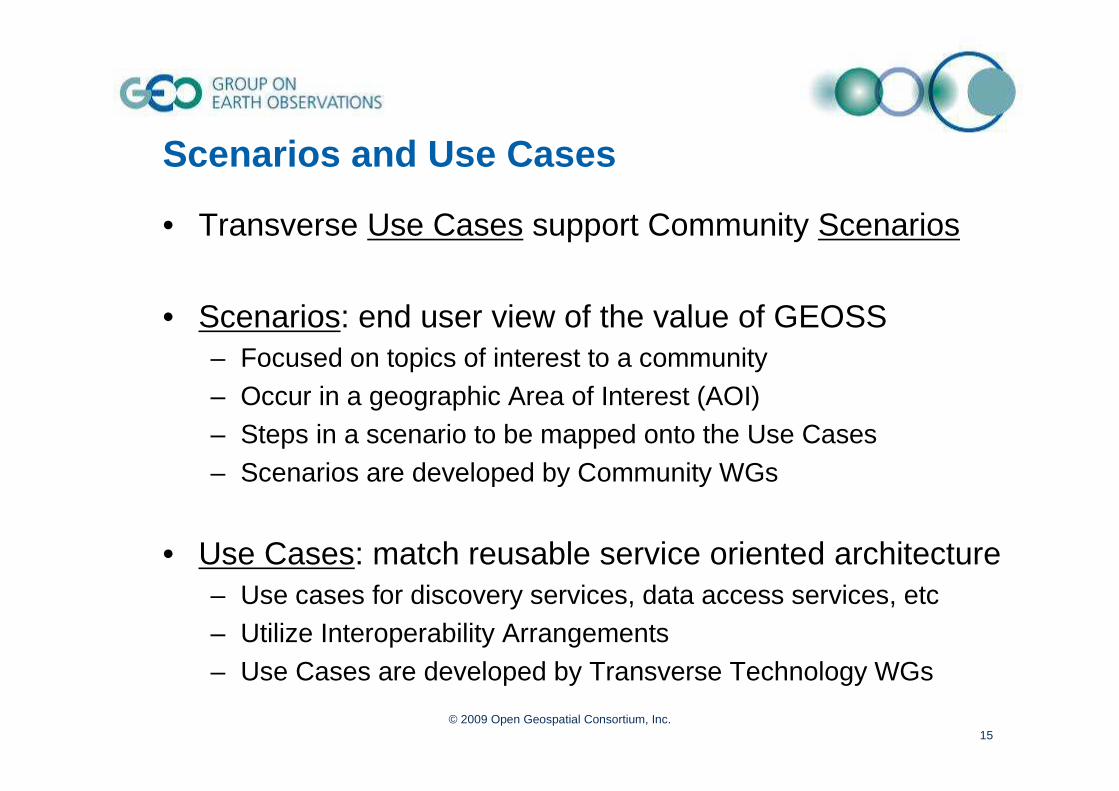
Scenarios and Use Cases
• Transverse Use Cases support Community Scenarios
• Scenarios: end user view of the value of GEOSS – Focused on topics of interest to a community – Occur in a geographic Area of Interest (AOI) – Steps in a scenario to be mapped onto the Use Cases– Scenarios are developed by Community WGs
• Use Cases: match reusable service oriented architecture– Use cases for discovery services, data access services, etc– Utilize Interoperability Arrangements– Use Cases are developed by Transverse Technology WGs
© 2009 Open Geospatial Consortium, Inc.15

AIP-2 Transverse Use Cases

AIP-2 Deliverables (GEO Task AR-09-01b)
• Demonstrations– Demonstration of community Scenarios implemented through
transverse Use Cases
– Demonstrations were recorded and made available via the Web• Persistent Exemplars
– Registered services (‘continuous operation’) should have 99% availability (~7 hours down time a month); on a reliable network; plan for performance scaling
– Nomination to operational task (AR-09-01a)
• Engineering Reports– Community Scenarios
– Technology Reports
– Use Cases Report (submitted as OGC Pending Doc, ref. 09-129 )– AIP-2 Summary Report (submitted as OGC Pending Doc, ref. 09-130 )
© 2009 Open Geospatial Consortium, Inc.17

AIP-2 Document Tree
GEOSS 10 Year Plan
GEOSS 10 Year Plan Reference
Document
AIP Architecture
(CFP Annex B)
Strategic & Tactical Guidance
Documents
AIP-2 Unified Modeling
ER(scenarios to
SOA)
SBA/CoP AIP Scenarios
SBA/CoP AIP Scenarios
AIP-2 SBA Scenario
ERs
AIP-2Use Cases
ER
AIP-2 Transverse
Technology ERs
AIP-2Summary
GCI IOC Task Force
Documents
SIFDocuments

GEOSS Architecture Implementation
1. What is GEOSS ?
2. The Architecture Implementation processes3. Pilot phase 2 (June 2008 - September 2009)
4. Targeting persistent, reusable components5. Applications
6. Pilot phase 3 perspectives
© 2009 Open Geospatial Consortium, Inc.19

AIP-2 Augmenting GCI
GEOSSClearinghouses
GEO Web Portals
GEOSS Common Infrastructure
Components & Services
Standards andInteroperability
Best PracticesWiki
User Requirements
Registries
Main GEOWeb Site
Registered Community Resources
Community Portals
Client Applications
Client Tier
Business Process Tier
CommunityCatalogues
AlertServers
WorkflowManagement
ProcessingServers
Access Tier
GEONETCastProduct Access
ServersSensor Web
ServersModel Access
Servers
Test Facility
MediationServers

Persistent Exemplar Services
• Criteria to be a persistent exemplar1. Registered in the Components and Services
Registry (CSR) as “Continuously Operational”2. Accessible through a GEOSS Interoperability
Arrangement that is an international standard. 3. Level of Service: Available >99% of the time (~7
hours downtime/month); Adequate network bandwidth and hardware for performance
• 192 services met criteria 1 & 2 as of 13 July 2009, – Methods to assess criterion #3 to be developed
© 2009 Open Geospatial Consortium, Inc.21

Services meeting Persistent Exemplar Criteria 1 and 2
© 2009 Open Geospatial Consortium, Inc.22

GEOSS Interoperability ArrangementsGEOSS Interoperability Arrangements-- From the GEOSS 10 Year Plan Reference Document From the GEOSS 10 Year Plan Reference Document --
• Interoperability through open interfaces– Interoperability specifications agreed to among contributing
systems– Access to data and information through service interfaces
• Open standards and intellectual property rights– GEOSS adopting standards agreed upon by consensus,
with preference to formal international standards– GEOSS will not require commercial or proprietary standards– Multiple software implementations compliant with the open
standards should exist– Goal is at least that one of the implementations should be
available to all implementers "royalty-free"© 2009 Open Geospatial Consortium, Inc.
23

AIP-2 summary
• All major AIP-2 activities are now complete• Major Achievements
– Six SBA Scenarios show use of GEOSS for communities of interest
– Reusable process for applying Service Oriented Architecture to other SBAs
– Augmentation of GCI: components, persistent exemplars, increase availability
• Presentation of results to GEO-VI Plenary, and Exhibit
© 2009 Open Geospatial Consortium, Inc.24

GEOSS Architecture Implementation
1. What is GEOSS ?
2. The Architecture Implementation processes3. Pilot phase 2 (June 2008 - September 2009)
4. Targeting persistent, reusable components5. Applications6. Pilot phase 3 perspectives
© 2009 Open Geospatial Consortium, Inc.25

AI Pilot has broad international participation that could only have occurred with GEO.
High interest & momentum supporting GEOSS vision.
AIP Phase 1 Results – Early 2008
• Elements of the GEOSS Common Infrastructure (GCI) – Initial Operating Capability established
• Effective development process for GEO– CFP, Kickoff, Execution, etc.– Approximately 120 organizations participated– Methods for international coordination
• Prepared “Architecture Implementation Report”• 10 Demonstrations of Initial Operating Capability
© 2009 Open Geospatial Consortium, Inc.26
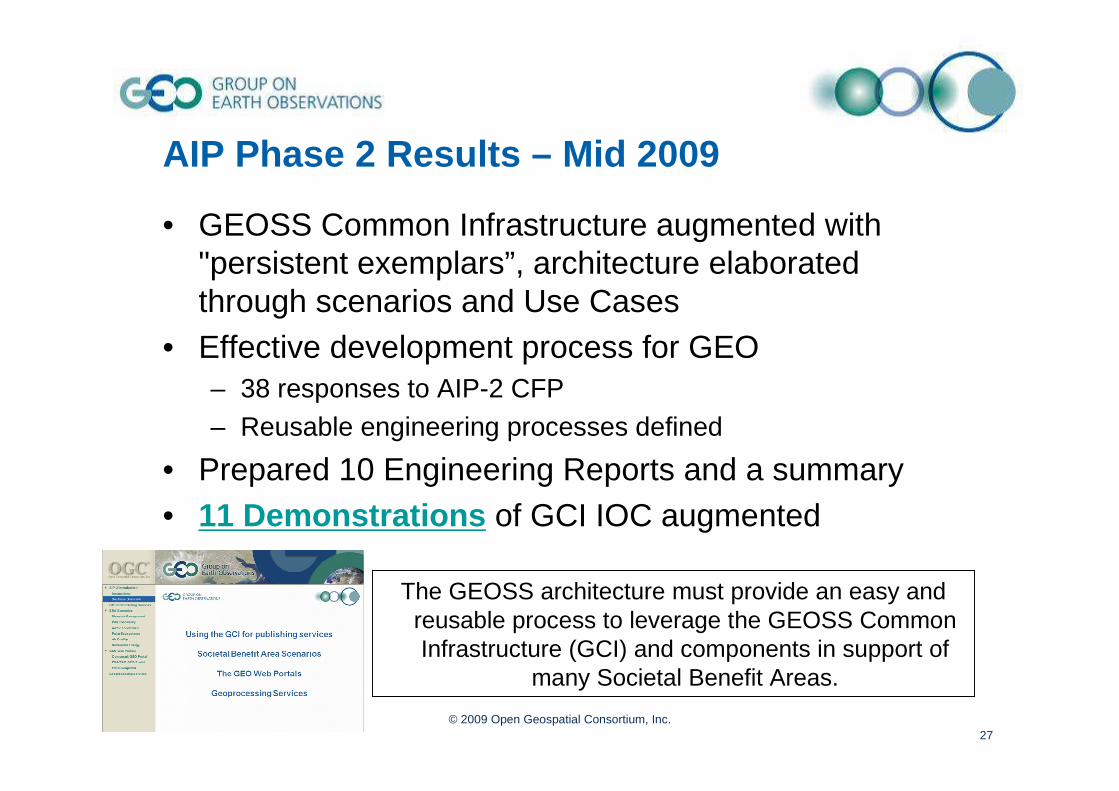
The GEOSS architecture must provide an easy and reusable process to leverage the GEOSS Common Infrastructure (GCI) and components in support of
many Societal Benefit Areas.
AIP Phase 2 Results – Mid 2009
• GEOSS Common Infrastructure augmented with "persistent exemplars”, architecture elaborated through scenarios and Use Cases
• Effective development process for GEO– 38 responses to AIP-2 CFP– Reusable engineering processes defined
• Prepared 10 Engineering Reports and a summary• 11 Demonstrations of GCI IOC augmented
© 2009 Open Geospatial Consortium, Inc.27

The GCI Initial Operations Capability
© 2009 Open Geospatial Consortium, Inc.28

A GEOSS workflow using the GCI
© 2009 Open Geospatial Consortium, Inc.29
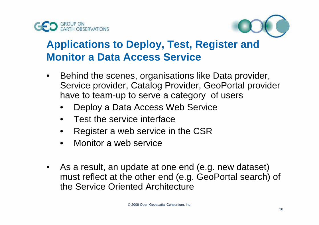
Applications to Deploy, Test, Register and Monitor a Data Access Service
• Behind the scenes, organisations like Data provider, Service provider, Catalog Provider, GeoPortal provider have to team-up to serve a category of users• Deploy a Data Access Web Service• Test the service interface• Register a web service in the CSR• Monitor a web service
• As a result, an update at one end (e.g. new dataset) must reflect at the other end (e.g. GeoPortal search) of the Service Oriented Architecture
© 2009 Open Geospatial Consortium, Inc.30

Decoders /
DB connectors
Decoders /
DB connectors
WCS interfaceWCS interface
CSRCSR
GEOSS Service Oriented ArchitectureOrganizations team-up to deliver service to the user
WMSWMS
ClearingH.ClearingH.
pub
res
req
test
reg
Harvest1
Harvest2
GeoPortalGeoPortal

Decoders /
DB connectors
Decoders /
DB connectors
WCS interfaceWCS interface
GEOSS Service Oriented ArchitectureThen user sees the tip of the iceberg…
req
res WMSWMS
req
resCSRCSR
ClearingH.ClearingH.
GeoPortalGeoPortal
Updating data sources & Monitoring Quality of Service, then supportingoperational contraints

UNEP ‘sFeature service (WFS)
SEDAC’sPopulation Estimation (WPS)
uDig plugin for interface with 52north WPS
Applications to Geo-Processing component

• Demonstrated capability to find, access, display, and use data from Myanmar, Ike, and Hannah events replayed from 2008
• Using the Geoportal to discover a community of interest portal (SIREN) and related data providers registered in the GEOSS registry
• Activity involved data provider components and services, and end user involvement from disaster management communities of interest
• Components and services remain ready to serve future needs, in particular, the Caribbean Flood Pilot GEO Task DI-09-02B
Application to Disasters Management SBA

• Investors and electricity producers willing to invest in solar plants need precise and thorough information to support decision-making.
• On their behalf, consulting companies perform feasibility studies in order to decide where to sit power plants and which technology to use ensuring a profitable return on investment.
• To reach that goal, consultants need an easy and unified access to data sets . Such data sets include meteorological , geographicaland environmentalparameters.
Download KMZ file
From user concern… …to on-line data and map delivery
JSR-168 Portlet Clientinput/output selection:• Area Of Interest (AOI)• Output scale• Optional layers
Output result as a KMZ archivecontaining:• Solar radiation layers (GeoTIFF) • Additional geographical and/or environemental layers
Application to Renewable Energy SBA
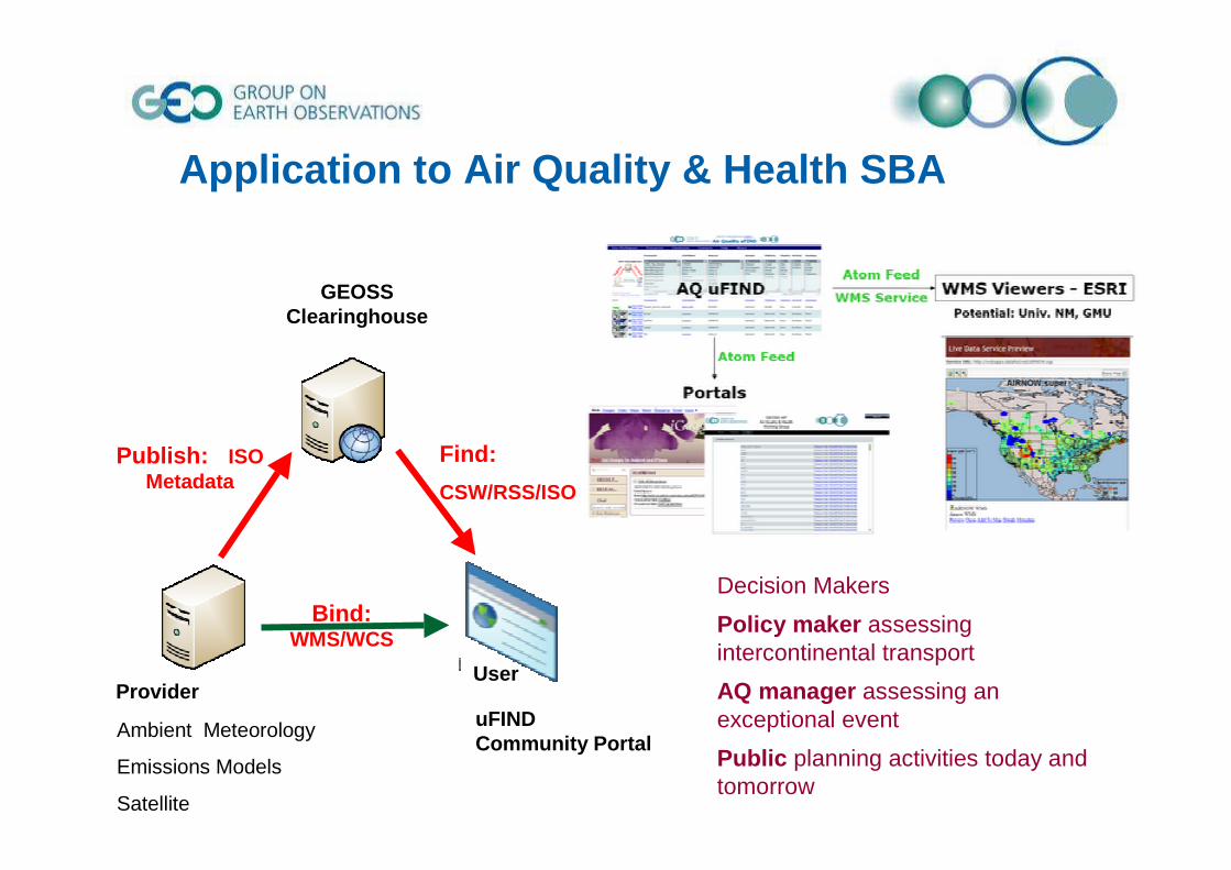
Find:
CSW/RSS/ISO
Bind: WMS/WCS
Publish: ISO Metadata
UserProvider
GEOSSClearinghouse
uFINDCommunity Portal
Ambient Meteorology
Emissions Models
Satellite
Decision Makers
Policy maker assessing intercontinental transport
AQ manager assessing an exceptional event
Public planning activities today and tomorrow
Application to Air Quality & Health SBA

Application to Polar Ecosystem vegetation

CC IMPACT ON PIKA DISTRIBUTION • This scenario is driven primarily by scientific research on the
distribution of distribution of pikapika and how it is changingand how it is changing. • GEOSS infrastructure perspective: to investigate the to investigate the
interoperability process to determine valuable predictors for thinteroperability process to determine valuable predictors for the e impact of climate change on biodiversityimpact of climate change on biodiversity
• Use observations of pika over the last 20 years, plus existing modeling demonstration systems, to model to model pikapika distributions and distributions and how they may change with climatehow they may change with climate
Area of Interest
The US Great Basin region (1x1 km)
Scientific patrons
Dr. Chris Ray (University of Colorado - CO USA)

CC IMPACT ON ARCTIC FOOD CHAIN• The scenario output will be as maps of Arctic biodiversity, habitat and maps of Arctic biodiversity, habitat and
ecological service changesecological service changes, as well as a summarized scenario runs a summarized scenario runs with all relevant metrics with all relevant metrics provided in a simple to comprehend table.
•• The scenario models will allow to assess the amount and quality The scenario models will allow to assess the amount and quality of of Ecological Services provided by the ArcticEcological Services provided by the Arctic.
• The activities are intended to be linked with all relevant components of the IPY (International Polar Year).
Area of Interest
The Arctic (as defined as the 60 degree latitude circle)
Scientific patrons
Dr. Falk HuettmannEWHALE lab- Biology and Wildlife Dept., Institute of Arctic Biology,
University of Alaska Fairbanks

IP3Client &
Workflow engine
IP3 Distributed Community Catalog/MediatorIP3 Distributed Community Catalog/Mediator
WCS - TOther Non-OGC Services GBIF
OpenModellerServer
Non-OGC Services
WPS (IP3 ENM)
CSW
req
resp
reqGEO Portal
req
WCS WFS
reqreq req
respresp resp
req
resp
reqreq
respresp
req
resp
req
resp
req
resp
Broker
Species, bathymetry...

GEOSS Architecture Implementation
1. What is GEOSS ?
2. The Architecture Implementation processes3. Pilot phase 2 (June 2008 - September 2009)
4. Targeting persistent, reusable components5. Applications
6. Pilot phase 3 perspectives
© 2009 Open Geospatial Consortium, Inc.41

GEOSS AIPGEOSS AIP--3 Plans 3 Plans -- SummarySummary
• Build on service architecture of GCI and AIP-2– Build on both content and process– Increase emphasis on data provider point of view– Promote mash-ups in a "link-rich" environment
• Engage Communities of Practice (CoP)– Continue AIP-2 CoPs– Identify new CoPs working with UIC and SBA Tasks
• Focus on data; Promote content– Coordination with ADC Data Tasks, data quality– Vocabulary registries and ontologies as resources for
scenarios– Data Sharing Guidelines implementation
• Schedule to support Ministerial Summit, November 2010
© 2009 Open Geospatial Consortium, Inc.42

AIPAIP--3 Communities of Practice 3 Communities of Practice -- DRAFTDRAFTScenario GEO Task/ CoP Status/comment
Emergency Management DI-06-09: Use of Satellites for Risk Management
AIP-2, GIGAS
Air Quality HE-09-02b AIP-2, ESIP Cluster
Biodiversity and Ecosystems
(BI-07-01a) AIP-2, EuroGEOSS, GIGAS
Energy EN-07-03 AIP-2
Hydrology and drought management
(WA-06-07c)(Water CoP)
EuroGEOSS, SDSC, FCU, (ESIP)
Oceans and coastal zones
(Coastal Zone CoP) (Oceans’09 GEOSS Workshop: Robert Weller)(Mediterranean workshop – Rob K)
Environmental Monitoring Sensor Webs
? (EPA, EEA)
Example : Water Example : Water CoPCoP in AIPin AIP --33
• Relevant GEO Tasks – Capacity Building for Water Resource Management – Asia
(WA-06-07c) – PoC, Chu Ishida, JAXA – (Water CoP - Rick Lawford - Drought)
• Responses to GEO Decision Support CFP– Assessing and predicting climate change effects on Water
Resources in South East Asia – SDSC, Univ. of Melbourne, Univ. of Malaya.
– Assessment and allocation decision model of limited water resource by open standards-based techniques – Feng ChiaUniversity
• Further resources– EC FP7 EuroGEOSS Drought Scenario– ESIP Federation: Water ontologies – Bill Sonntag
© 2009 Open Geospatial Consortium, Inc.44

AIP-3 Draft Schedule
© 2009 Open Geospatial Consortium, Inc.45

References
• GEO earthobservations.org
• GEO Architecture Implementation Pilotogcnetwork.net/AIpilot
• GEOSS registries and SIFgeossregistries.info
OGC Point of Contact :George Percivallgpercivall at opengeospatial.org
