arrival and approach procedure consultation document
TRANSCRIPT

Arrival and Approach Procedure Consultation DocumentMarch 2017
06763-DA-Newcair Air Space Doc March 6.indd 1 10/03/2017 10:51

1. Introduction 4 1.1 Welcome 4
2. What’s the purpose of this consultation? 6 2.1 Overview 6
2.2 What is RNAV? 6
2.3 RNAV (GNSS) Approach Procedures 7
2.4 Standard Arrival Routes (STARs): 7
3. Why amend procedures? 8 3.1 Overview 8
3.2 Drivers for Change 8
4. Options considered 104.1 Overview 10
4.2 Option 1: Do nothing 10
4.3 Option 2: Design new procedure routes 10
4.4 Option 3: Introduce a STAR for each runway 11
4.5 Option 4: Replicate current route (preferred option) 11
5. The RNAV (GNSS) proposal 12 5.1 Overview 12
5.2 The RNAV (GNSS) procedure 12
5.3 RNAV (GNSS) procedure in relation to surrounding area 17
6. The STAR proposal 18 6.1 Overview 18
6.2 The STAR 18
6.3 Other Maps and Charts showing the position of the STAR 19
Contents
2 | Arrival and Approach Procedure Consultation Document
06763-DA-Newcair Air Space Doc March 6.indd 2 10/03/2017 10:51

7. How could the change affect me? 20 7.1 Overview 20
7.2 Safety 20
7.3Efficiency 20
7.4 Environmental Impacts 21
7.5BenefitsofRNAV 23
8. Why consult? 24 8.1 Overview 24
8.2 Consultation Requirements 24
8.3 Consultation Process Concerns 25
9. Who is being consulted and how do I participate? 26 9.1 Who is Being Consulted? 26
9.2 How do I Submit my Response? 26
9.3 What do I Include in my Response? 26
9.4 What will happen to my Response? 26
9.5 How will I know the Result of the Consultation? 26
9.6 Deadline for Responses 26
10. What happens next? 28 10.1 Overview 28
10.2 CAA Actions 28
11. References 2912. Glossary 3013. Frequently Asked Questions (FAQ’s) 32
Arrival and Approach Procedure Consultation Document | 3
06763-DA-Newcair Air Space Doc March 6.indd 3 10/03/2017 10:51

1 Introduction1.1 Welcome
Newcastle International Airport (NIA) is the 10th largest airport in
the UK and the North East’s major airport, handling over 4.8 million
passengers per year through over 65,000 aircraft movements. From
our inception 80 years ago, NIA has placed the local communities we
serve at the heart of our business, seeking to ensure that our growth
is sustainable. We are therefore mindful of our ongoing commitment to
protect the amenity of our surrounding communities. Investment in new
technology, such as our recent acquisition of a new Noise and Track
Keeping (NTK) system demonstrates our commitment to monitoring
and reducing noise impact.
This document covers our proposal to implement Area Navigation
(RNAV) Global Navigation Satellite System (GNSS) Approaches and
Standard Terminal Arrival Routes (STARS). In implementing RNAV
(GNSS) approaches and STARS, we are looking to utilise the latest
technology such as satellite-based navigation systems to ensure
moreaccurateandpredictableflightpaths.Therouteswillduplicate
current operations. This will deliver greater fuel savings, reduced
emissions and will further improve the noise environment for people on
the ground.
Responsibility for the design, consultation, application and
implementationofaSTARisnormallytheresponsibilityoftheAirTraffic
Controlen-RouteagencyoperatedbyNationalAirTrafficServices
(NATS). In this instance, because of the close working relationship
between NATS and NIA, and the link between the proposed RNAV
procedures and STARS, this responsibility has been delegated to NIA.
If approved, our implementation of RNAV (GNSS) approaches
and STARS will keep NIA at the forefront of aviation environmental
impact reduction.
We want to continue to engage with our stakeholders and look forward
to hearing your thoughts, as your feedback is very important to us and
I strongly encourage you to let us have your views on this proposal.
Richard Knight Operations Director
4 | Arrival and Approach Procedure Consultation Document
06763-DA-Newcair Air Space Doc March 6.indd 4 10/03/2017 10:51

Arrival and Approach Procedure Consultation Document | 5
06763-DA-Newcair Air Space Doc March 6.indd 5 10/03/2017 10:51

2 What’s the purpose of this consultation?
Newcastle International Airport intends to modernise the flight procedures used by aircraft arriving at the Airport. This section provides an overview of the changes that are planned.
2.1 Overview
Most airports have standard arrival and departure routes that aircraft
use;theseprovidepredictabilityforcrewsandAirTrafficControl(ATC),
allows robust planning and management of safety of operations, and
effectively manages environmental impacts of aircraft operations.
Theseroutescanbeflownusingavarietyofnavigationalequipment
and techniques, depending on the infrastructure at the airport and the
equipmentintheaircraftcockpit.NIAalreadypublishandoperatefinal
approach procedures1 and standard routes for aircraft inbound from
the Airways System2, but wish to embrace new technology and utilise
satellite navigation. This document details a proposal to introduce
state-of-the-art RNAV (GNSS) approaches and STARs at NIA.
2.2 What is RNAV?
Traditionally, navigation of aircraft is achieved through location,
direction and bearing information transmitted from ground-based
stations or beacons into the cockpit. Instead of using data from these
beacons, RNAV-equipped aircraft draw their information from satellites,
in much the same way a car SatNav determines its location and
plansaroute.However,therearesignificantlymoresafetychecksof
the processes, procedures and integrity of the data for use in aircraft
navigation. Furthermore, GNSS provides data in three dimensions and
on-board computers allow suitably equipped aircraft to automatically
flytheprocedures.Upto90%ofairlinesusingNIAhavethecapability
to follow the procedures.
RNAV allows aircraft to follow routes that are no longer restricted to
ground-basedbeacons,providingadditionalflexibility,whichcanbe
usedtoreducethemilesflownandreleaseenvironmentalbenefits.
Further, more detailed information about RNAV can be found in the
CAA’s Flight Operations Division Communication 04/2008, Area
Navigation (RNAV) – CAA Guidance Material, available at
http://publicapps.caa.co.uk/docs/33/FOD200804.pdf
or CAP 773 Flying RNAV (GNSS) Approaches in Private and General
Aviation Aircraft available at
https://publicapps.caa.co.uk/docs/33/CAP773FINAL.pdf.
1 CAP 032 Integrated Aeronautical Information Package AD 2-EGNT-8-1 to 8-8 2 Ibid EGNT AD 2.22, para 1.
6 | Arrival and Approach Procedure Consultation Document
06763-DA-Newcair Air Space Doc March 6.indd 6 10/03/2017 10:51

2.3 RNAV (GNSS) Approach Procedures
NIAwouldliketointroduceRNAV(GNSS)finalapproachesforrunway
07 and 25 at the Airport, lining aircraft up with the runway and glide
pathsafelyfromapproximately10NauticalMiles(NM)away.These
RNAV (GNSS) approaches are intended to replicate the current
Instrument Landing System (ILS) approaches as a contingency or
alternate navigation procedure.
The RNAV (GNSS) approaches provide a stable, straight track to
flyandasteadydescentrateforthelast10NMoftheapproach
to facilitate a safe landing. However, the introduction of GNSS
procedures will allow suitably equipped aircraft to plan a continuous
decent from as far away as 50nm from touchdown, producing
significantlyimprovedfuelefficiency.
NIA is a participant in the Future Airspace Strategy (FAS), an industry
strategy group looking at development of airspace and navigation
within the UK up to 2020. RNAV implementation is a key aim of the
groupasitgivescapacity,environmentalandsafetybenefitsacross
the network. The ILS will be retained for the foreseeable future to
enable carriers who are not RNAV equipped to continue to operate to
the Airport.
2.4 Standard Arrival Routes (STARs)
NIA do not currently have any published STARs. A STAR is a
designatedinstrumentflightprocedurearrivalroutelinkinga
significantpoint,normallyonanAirTrafficService(ATS)route,with
a point from which a published instrument approach procedure (i.e.
an ILS or RNAV(GNSS) approach) can be commenced. NIA currently
publishes recommended routes for inbound aircraft; whilst these
routes can be used for planning purposes for inbound crews, in reality
aircraft will be provided radar vectors by ATC in order to maintain
sequencing and separation from other aircraft, and to position for the
approach procedure.
As detailed in the Airport Masterplan 2030 [Reference 1], NIA would
like to “formalise” the current procedures for inbound aircraft by
publishing them as STARs; thereby providing greater predictability of
aircraftrouteandtheopportunityforefficienciesbyreducingfuelburn,
resulting in lower monetary cost and CO2 emissions. The introduction
of STARs at NIA accords with UK and EU policies on Performance
Based Navigation (PBN) as it is:
“an essential component of delivering objectives underpinning
the Future Airspace Strategy and consequential modernisation
of the UK airspace system…laying the foundations for the
airspace system not just of tomorrow, but for years to come…”
(CAA – Performance Based Navigation) [Reference 2]
TheenvironmentalbenefitspresentedbytheintroductionofSTARs
will also contribute towards one of the government priorities for
aviation and a CAA Strategic Objective by:
“Improving the environmental performance through more
efficientuseofairspaceand(to)makeanefficientcontribution
to reducing the aviation industry’s environmental impacts.”
(CAP 1163 The CAA’s Environmental Programme 2014-2016)
[Reference 3].
Arrival and Approach Procedure Consultation Document | 7
06763-DA-Newcair Air Space Doc March 6.indd 7 10/03/2017 10:51

8 | Arrival and Approach Procedure Consultation Document
3 Why amend procedures?
The key driver to amend procedures is to modernise operating practices. In doing so, arrival routes will mirror current flight paths as much as possible with a greater degree of accuracy.
3.1 Overview
The intention to implement RNAV (GNSS) approaches and STARs was
announcedintheAirportMasterplan2030.Theywillenhanceexisting
arrivalproceduresatNIAandbeavailableforthoseaircraftfittedwith
the appropriate equipment.
3.2 Drivers for Change
3.2.1 Equipment ReliabilityWhen the new ATC tower was built in 2007, approaches using some
of the traditional ground-based equipment at NIA were withdrawn due
to infrastructure restrictions and the age of the Airport’s equipment.
Another approach procedure, the Surveillance Radar Approach
(SRA) to 1 NM, has recently been withdrawn as it is very rarely used
bycommercialaircraftandairtrafficcontrolofficerswereunableto
maintain adequate currency in providing this service. This leaves
aircraft with the option to use the ILS, the Non-Directional Beacon
(NDB) or a SRA to 2 NM from the runway, to make their approach.
However,theNDBisoldandunreliable,withsparepartsdifficultto
source, and it has to be switched off during thunderstorm activity,
further reducing the options available for pilots to make an approach
to NIA.
RNAV procedures do not need ground based equipment and therefore
are not subject to equipment maintenance schedules. They are
designed to use information from satellites for accurate navigation.
3.2.2 ModernisationThis consultation follows on from the consultation on Standard
InstrumentDepartures(SIDs)whicharenowinthefinalstagesof
implementation, and demonstrates a clear commitment from NIA
to embrace technological advances to put us at the leading edge
ofmodernflightproceduresandefficiency.Wearedeterminedto
becomeacentreofexcellenceforaircraftnavigationmakingNIA
moresustainable,morecost-efficientandmoreattractiveto
operational partners.
Performance-Based Navigation (PBN) is being adopted worldwide
through a United Nations4, European Community and UK policy
objective. The UK intends to meet the aims of this objective through
its Future Airspace Strategy (FAS)5. One of the key aims of FAS is to
makeairspacemoreefficientbyimprovingtheaccuracyofwhere
aircraftflybyusingsatellite-basednavigationinsteadofground-based
navigation aids, i.e. PBN. Although not currently mandated in the UK,
NIA is forward-thinking and intends to adopt the advantages PBN can
offer therefore proactively preparing for probable national
policy changes.
3.2.3 Environmental ConcernsRNAVproceduresoffertheopportunityformoreefficientflights,
saving fuel costs and reducing CO2 emissions. This ties in with
government priorities for aviation and is one of the CAA’s
Strategic Objectives.
A long-standing aim of our Noise Action Plan is to reduce ‘scattering’
of aircraft on approach to the Airport; RNAV (GNSS) approach
procedures will produce highly repeatable, more predictable routes.
Whilst NIA already supports a policy of improving the implementation
of Continuous Descent Operations (CDO), a CAA objective within the
CAA Policy CAP 1165 Managing Aviation Noise, CDO will be more
readily achieved using RNAV arrival and approach procedures, further
reducing noise and emissions.
4 The UN International Civil Aviation Organisation (ICAO) has an action plan to roll out PBN and to promote more sustainable aviation through its Committee on Aviation Environment Protection. ICAO member states (including the UK) are expected to adopt PBN at the fastest practicable rate.5 Future Airspace Strategy for the United Kingdom 2011 to 2030, available at: http://www.caa.co.uk/WorkArea/DownloadAsset.aspx?id=4294078317
8 | Arrival and Approach Procedure Consultation Document
06763-DA-Newcair Air Space Doc March 6.indd 8 10/03/2017 10:51

Arrival and Approach Procedure Consultation Document | 9
3.2.4 SafetySafety of operations is always of paramount concern to NIA. Many
safetysystemsareinplacetoensurethatairtrafficprocedureshave
built-in redundancy and are repeatable and predictable. A national
programme to remove some ground-based navigational beacons has
hadadirectimpactonNIAflightproceduresandreducedtheoptions
available.Weintendtofuture-proofoperationalflightprocedures
and re-introduce a higher level of redundancy of procedures by
implementing RNAV (GNSS) approach procedures. The STARs will
provide a greater level of predictability in routing and will reduce the
amountofATCand/oraircrewinputrequiredtoflytheprocedures.
Anyreductioninworkload,especiallyduringbusytrafficperiods,is
beneficialinallowingcontrollerstomaintainasafeandexpeditious
flowofairtraffic.
3.2.5 Economic DriversThe environmental and economic case for RNAV is clearly evident and
NIA believes that voluntary early compliance with PBN implementation
policy will prove to be the most cost effective and sustainable
approach. This method is fully supported by our airlines, who want
this new technology to be implemented as soon as possible. RNAV
procedurescanbeintroducedwithnofinancialoutlayonground-
based equipment and there are no associated maintenance costs to
the Airport. By implementing the RNAV programme now NIA is not
only seen to be optimising operations for its customers’ airlines, but
future-proofingthebusinessbypositioningitselftotakeadvantageof
futurecostsavingopportunitiesprovidingbenefitstoalltheAirport’s
user community, including passengers.
Arrival and Approach Procedure Consultation Document | 9
06763-DA-Newcair Air Space Doc March 6.indd 9 10/03/2017 10:51

10 | Arrival and Approach Procedure Consultation Document
4 Options considered
Several options were developed by the Airport to consider how to meet the requirements in a proportional manner, minimising the impact on other airspace users and local residents. This section outlines the potential solutions.
4.1 Overview
The initial list of options considered the potential to:
• Donothing;
• Changeproceduresandairspace;
• IntroduceaSTARforeachrunway;or
• Replicatecurrentroute.
4.2 Option 1: Do nothing
Under the UK’s FAS, PBN is due to be introduced and potentially
mandated in the near future. It is an aim under the European Aviation
Safety Agency (EASA), as published in their Performance-based
navigationimplementationintheEuropeanairtrafficmanagement
network [Reference 4], for PBN SIDs and STARs to be introduced by
December 2018 and PBN approach procedures with vertical guidance
by January 2020. The economic and environmental advantages that
can be gained from the introduction of RNAV procedures, combined
with the potential minimal effects to other stakeholders led NIA to
determine that to “Do Nothing” is not a viable option.
4.3 Option 2: Design new procedure routes
NIA considered how changing the current routes might provide
additionalefficienciesand/orallowtheAirporttomitigatetheeffects
on the local population by designing routes for respite. Careful
assessment was made of the contents of CAP 1378 Performance-
based Navigation, Airspace Design Guidance: Noise mitigation
considerations when designing PBN departure and arrival procedures
[Reference 5]. The document provides guidance on a range of design
options for PBN procedures with the intention of offering options for
different kinds of noise mitigation guidance, including varying degrees
of relief and dispersal.
The majority of options for PBN arrivals outlined in CAP 1378, other
than direct replication of current, conventional procedures, would
require additional controlled airspace (CAS) to be established around
NIA to contain the new procedures. In broad terms, CAS requires
pilotstospeaktothecontrollingATCunitbeforeenteringandtoflyin
accordance with the clearance provided. This allows ATC to maintain
fullsituationalawarenessoftheintentionsofairtrafficwithintheir
airspace, thereby permitting early planning and the maintenance of
safety of all aircraft. Outside CAS, there is no obligation for pilots to
beincontactwithATCandtheairtrafficservicesprovidedaremore
reactive.
A STAR should be contained by CAS; Newcastle is the controlling
authority for some CAS, which is joined to the UK’s en-route structure
by Airway6 P18. The current NIA airspace was designed to contain our
current procedures; to widen procedures to provide an alternate route
for noise respite would result in the procedures no longer being fully
contained.ThiswouldrequireNIAtoseekapprovalforanextension
to our CAS and we would need to demonstrate that the airspace
requestedisproportionaltothebenefitsdelivered,asCASisseenas
restrictivetotheGeneralAviation(GA)community.Thejustificationto
achangetotheairspacewillbeassessedintermsofsafety,efficiency,
providingenvironmentalbenefitsormitigatingitsenvironmentalimpact
tothegreatestextentpossible.However,inachievinganyofthese
objectives at the Airport, we may produce an adverse effect on these
aspects for other airspace users.
It is NIA’s view that to develop and implement additional routes that
will require additional airspace is not a proportional response to the
Airport’s need to introduce RNAV arrival and approach procedures.
The current number of aircraft movements does not merit the potential
impacts on other airspace users that additional airspace could bring.
Thenextstageofairspacedevelopmentwillbetoinvestigatethe
viability of increasing NIA controlled airspace. This is likely to be
needed in the near term to protect projected growth.
10 | Arrival and Approach Procedure Consultation Document
6 An airway is defined “corridor” in the air for aircraft, usually of CAS.
06763-DA-Newcair Air Space Doc March 6.indd 10 10/03/2017 10:51

Arrival and Approach Procedure Consultation Document | 11
4.4 Option 3: Introduce a STAR for each runway
On an average summer day in 2016 NIA handled 70 arrivals. In 2014,
P18wasusedby58%ofNIAarrivals.TheAirwayP18iscontrolledby
NATSatthePrestwickAirTrafficControlCentre,whoareresponsible
for integrating aircraft that are arriving to and departing from many UK
airportswiththosethatflythroughUKairspacetootherinternational
locations.AircraftflyingtoandfromNorthernEuropeanandEast
Scottish airports route through the overhead of NIA, navigating via
a reporting point called NATEB (located directly above NIA). NATS
implementaTrafficOrientationScheme,shownatFigure1,toprovide
effectiveintegrationofthebusyairtrafficenvironmentonAirwayP18.
TheTrafficOrientationSchemerequiresaircraftinboundtoNewcastle
(red arrow) to route up the east side of Airway P18, and aircraft
departing from the Airport (green arrow) down the west side of the
Airway. When Runway 25 is in use and aircraft make their approach
from the east of the Airport and depart facing west, an easy circular
flowispossible.However,whenusingtheoppositeorientationof
the Runway, departures get airborne in an easterly direction and
must cross to the west side of Airway P18 for their onward journey,
requiringdeconflictionfromtheinboundaircraftroutinguptheeast
side of the Airway.
A proposal was made for two STARs to be introduced- one for
eachrunway.However,insurmountabledifficultieswereidentified
with this proposal. A two-STAR solution that complied with the
TrafficOrientationSchemecouldnotbedevisedandthesecond
STAR would adversely impact on an airspace usage agreement
with the operators of a gliding site, 9 NM southwest of the Airport.
Furthermore, separation against the Runway 07 Standard Instrument
Departure(SID)atNIAwouldbedifficulttoachieve.
These factors, combined with the restrictions on the volume and
dimensions of current CAS, showed an option for two STARs was not
viable.
4.5 Option 4: Replicate current route (preferred option)
NIA believe the option to replicate the current route, which will result
in little or no change for the majority of residents is the preferred
option. The following factors have driven this decision:
-TherestrictionsplaceduponNIAbytheP18Traffic
Orientation Scheme
- desire to avoid adverse impacts on other airspace users by
resistingexpansionofourCAS
- need to maintain safe separation from other procedures
and operations
-ourwishtominimisethenumberofresidentsoverflownhave
driventheneedtoreplicatetheroutescurrentlyflownbyaircraft
arriving at the Airport.
The RNAV (GNSS) approaches have been designed with this in mind.
Arrival and Approach Procedure Consultation Document | 11
Figure 1
06763-DA-Newcair Air Space Doc March 6.indd 11 10/03/2017 10:51

12 | Arrival and Approach Procedure Consultation Document
5 The RNAV (GNSS) proposal
This section outlines what the new RNAV (GNSS) approach procedure will look like.
5.1 Overview
The new RNAV (GNSS) approach procedure will replicate the route and
descentratecurrentlyflownbyaircraftlandingatNIAthatareusing
conventional, ground-based equipment.
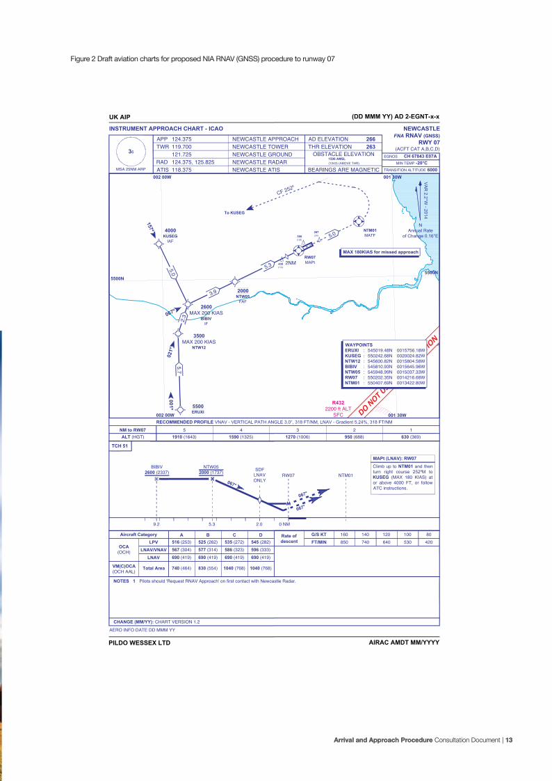
5.2 The RNAV (GNSS) procedure
The draft aviation chart for the RNAV (GNSS) procedures are provided
at Figures 2 - 5.
The following charts are aimed at the aviation audience.
12 | Arrival and Approach Procedure Consultation Document
06763-DA-Newcair Air Space Doc March 6.indd 12 10/03/2017 10:51
Arrival and Approach Procedure Consultation Document | 13 Arrival and Approach Procedure Consultation Document | 13
R4322200 ft ALT
SFC
388(125)
297(34)
435(172)
CF 252º
5.75.0
2.3
3.9
5.3 2NM
5.0
5500ERUXI
3500MAX 200 KIAS
NTW12
2600MAX 200 KIAS
BIBIVIF
4000KUSEG
IAF
2000NTW05
FAF
RW07MAPt
NTM01MATF
To KUSEG
001º
021º
067º
157º
5500N
DO NOT USE FO
R NAVIGATIO
N
INSTRUMENT APPROACH CHART - ICAO
AIRAC AMDT MM/YYYY
MAPt (LNAV): RW07
0 NM
NTM01
NTW052000 (1737)
BIBIV2600 (2337)
067°
PILDO WESSEX LTD
UK AIP (DD MMM YY) AD 2-EGNT-x-x
APP 124.375
TCH 51
NEWCASTLEFNA RNAV (GNSS)
RWY 07(ACFT CAT A,B,C,D)TWR 119.700
121.725RAD 124.375, 125.825ATIS 118.375
NEWCASTLE APPROACHNEWCASTLE TOWER
AD ELEVATION 266THR ELEVATION 263
BEARINGS ARE MAGNETIC
OBSTACLE ELEVATION1506 AMSL(1243) (ABOVE THR)
NEWCASTLE GROUNDNEWCASTLE RADARNEWCASTLE ATISMSA 25NM ARP
MIN TEMP -20°CTRANSITION ALTITUDE 6000
EGNOS CH 67843 E07A
RECOMMENDED PROFILE VNAV - VERTICAL PATH ANGLE 3.0°, 318 FT/NM, LNAV - Gradient 5.24%, 318 FT/NM
NM to RW07ALT (HGT)
1630 (369)
Climb up to NTM01 and thenturn right course 252ºM toKUSEG (MAX 180 KIAS) ator above 4000 FT, or followATC instructions.
5.39.2
RW07
067°
067°
CHANGE (MM/YY): CHART VERSION 1.2
NOTES 1 Pilots should 'Request RNAV Approach' on first contact with Newcastle Radar.
Aircraft Category A B C D516 (253) 525 (262) 535 (272) 545 (282)
596 (333)586 (323)577 (314)567 (304)690 (419)
LPVLNAV/VNAV
LNAV
OCA(OCH)
VM(C)OCA(OCH AAL)
Total Area 740 (464) 830 (554) 1040 (768) 1040 (768)
Rate ofdescent
G/S KTFT/MIN
160850
140740
120640
100530
80420
AERO INFO DATE DD MMM YY
36
2950 (688)
31270 (1006)
41590 (1325)
51910 (1643)
VA
R 2.2°W
- 2014
NAnnual Rate
of Change 0.16°E
001 30W
5500N
002 00W
5500N
002 00W 001 30W
WAYPOINTSERUXI : 545019.48N 0015756.18WKUSEG : 550242.68N 0020024.82WNTW12 : 545600.82N 0015804.58WBIBIV : 545810.93N 0015645.96WNTW05 : 545948.99N 0015037.33WRW07 : 550202.35N 0014216.68WNTM01 : 550407.69N 0013422.80W
690 (419) 690 (419) 690 (419)
SDFLNAVONLY
2.0
MAX 180KIAS for missed approach
Figure 2 Draft aviation charts for proposed NIA RNAV (GNSS) procedure to runway 07
06763-DA-Newcair Air Space Doc March 6.indd 13 10/03/2017 10:51

R4322200 ft ALT
SFC
To FNA RNAV RWY07
4.1
9.3
5.75.0
2.3
3.9
FL090ETSES
IAF
5500ERUXI
6000MAX 230 KIAS
XEBUP
3500MAX 200 KIAS
NTW12
2600MAX 200 KIAS
BIBIVIF
4000KUSEG
IAF
2000NTW05
FAF
TAA3900
TAA3400
(BIBIV)
(KUSEG)
(BIBIV)
(ERUXI)
25 NM FROM KUSEG
25 NM FROMER
UXI
(BIBIV)
25NMFROMBIBIV
TAA4100
301º
341º
021º
067º
157º
001º
INSTRUMENT APPROACH CHART - ICAO
AIRAC AMDT MM/YYYYPILDO WESSEX LTD
001 30W
WAYPOINTSETSES : 544157.09N 0014126.13WXEBUP : 544629.31N 0015524.85WERUXI : 545019.48N 0015756.18WKUSEG : 550242.68N 0020024.82WNTW12 : 545600.82N 0015804.58WBIBIV : 545810.93N 0015645.96WNTW05 : 545948.99N 0015037.33W
DO NOT USE FO
R NAVIGATIO
N
UK AIP (DD MMM YY) AD 2-EGNT-x-x
APP 124.375
NEWCASTLE INA RNAV (GNSS)
RWY 07(ACFT CAT A,B,C,D)TWR 119.700
121.725RAD 124.375, 125.825ATIS 118.375
NEWCASTLE APPROACHNEWCASTLE TOWER
AD ELEVATION 266THR ELEVATION 263
BEARINGS ARE MAGNETIC
OBSTACLE ELEVATION1506 AMSL(1243) (ABOVE THR)
NEWCASTLE GROUNDNEWCASTLE RADARNEWCASTLE ATISMSA 25NM ARP
MIN TEMP -20°CTRANSITION ALTITUDE 6000
36EGNOS CH 67843 E07A
VA
R 2.2°W
- 2014
NAnnual Rate
of Change 0.16°E
CHANGE (MM/YY): CHART VERSION 1.2
AERO INFO DATE DD MMM YY
5500N
002 00W
5500N
002 00W 001 30W
Figure 3 Draft aviation charts for proposed NIA RNAV (GNSS) procedure to runway 07
14 | Arrival and Approach Procedure Consultation Document
06763-DA-Newcair Air Space Doc March 6.indd 14 10/03/2017 10:51

Arrival and Approach Procedure Consultation Document | 15 Arrival and Approach Procedure Consultation Document | 15
337º
157º
247º
4000UPMOP
4000ASGEB
IAF
2000NTE06
FAF
4.0
5.4
5.0
CF 062º
5.4
4.0RW25MAPt
NTM02MATF
2600MAX 200 KIAS
SUPIGIF
388(149)
297(58)
435(196)
To ASGEB
001 30W
5500N
INSTRUMENT APPROACH CHART - ICAO
AIRAC AMDT MM/YYYY
MAPt (LNAV): RW25
0 NM
NTM02
NTE062000 (1761)
SUPIG2600 (2361)
247°
PILDO WESSEX LTD
DO NOT USE FO
R NAVIGATIO
N
UK AIP (DD MMM YY) AD 2-EGNT-x-x
APP 124.375
TCH 51
NEWCASTLEFNA RNAV (GNSS)
RWY 25(ACFT CAT A,B,C,D)TWR 119.700
121.725RAD 124.375, 125.825ATIS 118.375
NEWCASTLE APPROACHNEWCASTLE TOWER
AD ELEVATION 266THR ELEVATION 239
BEARINGS ARE MAGNETIC
OBSTACLE ELEVATION1506 AMSL(1267) (ABOVE THR)
NEWCASTLE GROUNDNEWCASTLE RADARNEWCASTLE ATISMSA 25NM ARP
MIN TEMP -20°CTRANSITION ALTITUDE 6000
EGNOS CH 87385 E25A
RECOMMENDED PROFILE VNAV - VERTICAL PATH ANGLE 3.0°, 318 FT/NM, LNAV - Gradient 5.24%, 318 FT/NM
NM to RW25ALT (HGT)
1610 (369)
Climb up to NTM02 and thenturn right course 062ºM toASGEB (MAX 180 KIAS) ator above 4000 FT, or followATC instructions.
5.4 9.4
RW25
247°
247°
CHANGE (MM/YY): CHART VERSION 1.2
NOTES 1 Pilots should 'Request RNAV Approach' on first contact with Newcastle Radar.
Aircraft Category A B C D501 (262) 511 (272) 521 (282) 530 (291)
518 (279)491 (252)489 (250)489 (250)640 (396)
LPVLNAV/VNAV
LNAV
OCA(OCH)
VM(C)OCA(OCH AAL)
Total Area 740 (464) 830 (554) 1040 (768) 1040 (768)
Rate ofdescent
G/S KTFT/MIN
160850
140740
120640
100530
80420
AERO INFO DATE DD MMM YY
36
2930 (688)
31250 (1006)
41560 (1325)
51880 (1643)
VA
R 2.2°W
- 2014
NAnnual Rate
of Change 0.16°E
WAYPOINTSUPMOP : 550131.69N 0012146.79WASGEB : 551057.54N 0012920.76WSUPIG : 550625.56N 0012542.06WNTE06 : 550445.01N 0013201.84WRW25 : 550230.46N 0014030.76WNTM02 : 550049.73N 0014649.27W
001 30W
5500N
MAX 180KIAS for missed approach
640 (396) 640 (396) 640 (396)
Figure 4 Draft aviation charts for proposed NIA RNAV (GNSS) procedure to runway 25
06763-DA-Newcair Air Space Doc March 6.indd 15 10/03/2017 10:51

16 | Arrival and Approach Procedure Consultation Document
R4322200 ft ALT
SFC
9.9
013º
046º
337º
157º
247º
5.4
5.0
13.8
4.0
To FNA RNAV RWY25
25NM
FRO
MA
SGEB
TAA
3900
TAA
2900
(SUPIG)
(ASGEB)
(SUPIG)
(UPMOP)
FL090ETSES
IAF
6000NTS29
MAX 250 KIAS
4000UPMOP
4000ASGEB
IAF
2600MAX 200 KIAS
SUPIGIF
2000NTE06
FAF
25NM
FROM UPMOP
001 30W
INSTRUMENT APPROACH CHART - ICAO
AIRAC AMDT MM/YYYYPILDO WESSEX LTD
001 30W
WAYPOINTSETSES : 544157.09N 0014126.13WNTS29 : 545137.68N 0013819.19WUPMOP : 550131.69N 0012146.79WASGEB : 551057.54N 0012920.76WSUPIG : 550625.56N 0012542.06WNTE06 : 550445.01N 0013201.84W
DO NOT USE FO
R NAVIGATIO
N
UK AIP (DD MMM YY) AD 2-EGNT-x-x
APP 124.375
NEWCASTLE INA RNAV (GNSS)
RWY 25(ACFT CAT A,B,C,D)TWR 119.700
121.725RAD 124.375, 125.825ATIS 118.375
NEWCASTLE APPROACHNEWCASTLE TOWER
AD ELEVATION 266THR ELEVATION 239
BEARINGS ARE MAGNETIC
OBSTACLE ELEVATION1506 AMSL(1267) (ABOVE THR)
NEWCASTLE GROUNDNEWCASTLE RADARNEWCASTLE ATISMSA 25NM ARP
MIN TEMP -20°CTRANSITION ALTITUDE 6000
36EGNOS CH 87385 E25A
VA
R 2.2°W
- 2014
NAnnual Rate
of Change 0.16°E
CHANGE (MM/YY): CHART VERSION 1.2
AERO INFO DATE DD MMM YY
5500N5500N
Figure 5 Draft aviation charts for proposed NIA RNAV (GNSS) procedure to runway 25
06763-DA-Newcair Air Space Doc March 6.indd 16 10/03/2017 10:51

5.3 RNAV (GNSS) procedure in relation to surrounding area
Figure6showstheroutethataircraftwillflyfromtheendofthe
proposed STAR (see Section 8) to the runway using the proposed
RNAV (GNSS) procedure. The map also displays indicative altitude
heights and distances from the runway in nautical miles (NM).
Arrival and Approach Procedure Consultation Document | 17
Figure 6 Track over the ground of the proposed NIA RNAV (GNSS) procedure
3000ft
5500ft
2000ft4000ft
6000ft
10NM
10NM
06763-DA-Newcair Air Space Doc March 6.indd 17 10/03/2017 10:51

18 | Arrival and Approach Procedure Consultation Document
6 The STAR proposal
This section outlines what the new STAR procedure will look like.
6.1 Overview
The proposed STAR adopts a similar route as that already published in
the UK Integrated Aviation Information Package (UKIAIP) as a route for
aircraft inbound from the airways system.
It is offset to the East of the airway (P18 Centre line).
6.2 The STAR
A chart showing the new STAR in relation to the surrounding airspace
is provided at Figure 7.
18 | Arrival and Approach Procedure Consultation Document
7 CAP 032 IAIP EGNT AD 2.22 paragraph 1(a).
Figure 7 Chart showing proposed NIA RNAV
STAR in relation to surrounding airspace
06763-DA-Newcair Air Space Doc March 6.indd 18 10/03/2017 10:51

Arrival and Approach Procedure Consultation Document | 19 Arrival and Approach Procedure Consultation Document | 19
6.3 Other Maps and Charts showing the relative position of the STAR
Figure 8 shows the track of the proposed STAR in relation to the
geographical background and local centres of population.
Figure 8 Proposed STAR in relation to
local centres of population (in yellow)
06763-DA-Newcair Air Space Doc March 6.indd 19 10/03/2017 10:51

7 How could this proposal affect me?
Any change to operations at an airport will be likely to produce an effect on those surrounding the airport. NIA have assessed the proposal to minimise any impacts and manage any residual effects.
7.1 Overview
The effects resulting from the proposed changes to arrival and
approach procedures at NIA have been assessed in terms of safety,
efficiencyandenvironmentalimpactsinrelationtothetwomaingroups
of aviation and non-aviation stakeholders.
7.2 Safety
There are not considered to be any adverse impacts to aviation
stakeholders from the introduction of RNAV arrival and approach
proceduresatNIA;noadaptationstotheexistingCASstructureare
being proposed, there will be no changes to airspace crossing for
GAormilitaryaircraftandexistingLettersofAgreementwithaviation
organisations will not need to be changed. Conventional procedures
will remain available for aircraft to use that are not RNAV-equipped.
SafetybenefitswillbeprovidedtoNIAaircraftoperatorsandATC
including: Reduced controller and pilot workload.
7.3 Efficiency7.3.1 Aviation StakeholdersForflightsutilisingthenewRNAVroutes,fuelandmaintenancecosts
will reduce through:
• Reducedtrackmilesflown;
• Reducedenginethrust;
• Reducedfuelusedthroughreducingthecontingencyfuel
requirements:
• Theamountoffuelcurrentlyloadedontoanaircraftcatersfora
much less direct route than can be achieved through RNAV. As
RNAV routes can be pre-planned and are more direct, the aircraft
captain can reduce how much fuel must be carried. This improves
thefuelefficiencyofthewholeflightbyreducingtheaircraftweight
at take-off8;
• Reducedoperatinghoursandwearandtearonaircraft,resultingin
reduced maintenance costs.
EUROCONTROL studies and other trials have demonstrated fuel
savingsofupto40%canbeachievedthroughtheuseofCDOs
duringtheapproachphaseofflights.Thisequatestobetween50and
150 kg of fuel savings, depending on the level at which the CDO is
commenced and the aircraft type.
7.3.2 Non-aviation Stakeholders
NIA is a key economic asset and important driver for the North East
economy.NIAfacilitateseconomicbenefitsincludingbusinesslinks,
inbound tourism and employment not only at the airport, but for all the
businesses that rely on us. It also offers a gateway to the world for local
people. Operations that can help us to grow in a more sustainable way
or to reduce our environmental impact are good for the regional and
nationaleconomy.OneofthekeybenefitsfromRNAVistosignificantly
reduce the operating costs of airlines using NIA through fuel savings
andshorterflyingtimes.Thishasthepotentialtoattractmoreairlines.
7.4 Environmental impacts
7.4.1 NoiseIn terms of assessing the effects of new procedures, consideration is
given to the impact of noise from aircraft below 7,000 ft. There will be
no noise impact from the STAR itself as it terminates at 9000 ft. Whilst
guidance states that noise is only considered below is only considered
below 7,000 ft, a qualitative assessment has been carried out on the
noise impact of RNAV.
Department for Transport Guidance to the CAA on environmental
objectives,relatingtoexerciseofitsAirNavigationFunctions(Jan
14’),acknowledgesthatPBNresultsinfewerpeoplebeingexposed
to noise than occurs with conventional procedures. NIA believe the
environmentalbenefitsoverallwillbepositive.
One of the advantages of RNAV is that those aircraft using RNAV
procedureswillflyamorepredicableroute,reducingthepresent
‘scatter’ of aircraft on approach. This will slightly reduce the number of
overflighteventsforthemajorityofpeoplethatarepresentlyoverflown
byaircraftonapproachduetoaircraftfollowingamoredefinedroute.
8 A reasonable approximation requires 3% extra fuel to be carried for each hour of flight. On a 5 hour flight, 15kg of fuel is typically used unnecessarily for every 100kg of unused and un-needed fuel carried to landing
20 | Arrival and Approach Procedure Consultation Document
06763-DA-Newcair Air Space Doc March 6.indd 20 10/03/2017 10:51

Figure 9 Runway 25 arrivals 26th August 2016
Figure 10 Runway 07 arrivals 19th August 2016
Arrival and Approach Procedure Consultation Document | 21
06763-DA-Newcair Air Space Doc March 6.indd 21 10/03/2017 10:51

Those people living directly under the RNAV procedures will see some
additional aircraft that are more directly overhead. The aircraft following
theRNAVprocedureshowever,willbeflyinghigherbecausetheywill
followaCDOprofilewithreducedpowersettings,thusmakingless
noisethaniftheyhadoverflownusingpresenttechniques.
Figure 9 and 10 show the spread of routes to each runway, taken by
aircraft arriving at NIA on a typical summer’s day using the current
conventional arrival procedures. Using RNAV approach procedures,
the aircraft tracks will be concentrated to those shown in yellow
andatFigure6.Greaterdetailcanbeviewedonthespecificarea
information sheets.
Theoverallchangetoaveragenoiseimpactexperiencedontheground
is likely to be less than 1dBA at some distance from the runway; this
is too small to be modelled accurately. Changes of this magnitude
(<1dB) to average noise are not normally perceived as noticeable by
most people (less than the noise of chuckling water or rustling leaves at
10 meters). National studies undertaken by the UK CAA9 have shown
that the noise levels from aircraft on approach at this distance from the
airport generally plays little role in sleep disturbance for the majority
of people. All RNAV approaches will facilitate Continuous Descent
Operations (CDO) where an aircraft descends following an optimised
verticalprofileusingminimumenginethrust.TheuseofRNAVwill
optimisethistechniquetothemaximumextentpossibleusingon-
boardflightsystems.CDOwillalsokeepaircrafthigherabovethe
ground than currently used conventional approaches, which typically
reduce aircraft descent rates and/or require aircraft to level-off
periodically, to allow separation and sequencing for landing. Figure 9
showstheidealdescentprofileforanaircraftona3degreeapproach
angle(dashedblackline,descendingapproximately300feet(ft)
perNM),alongwiththeprofiletobeexpectedfromanRNAVarrival
(blue line) and that likely to be achieved under conventional radar
vectors (red line). It demonstrates that a continuous descent is more
achievable from 14,000 ft for an aircraft conducting a RNAV arrival
(maintaining height as long as possible), than one using conventional
techniques. The additional height and the reduced engine thrust from
more optimised CDO will reduce the noise perceived on the ground
under the RNAV procedures to a small degree.Controllers at NIA
alreadyfacilitateaformofCDOforasmanyflightsaspossibleusing
standard controlling techniques. Controllers inform the aircraft how
far they are from touchdown and where possible allow the aircraft
tocalculateitsownbestdescentprofile.Thisisconstrainedslightly
wherethereisotherconflictingtraffic,orwhereCASmaylimitthe
descentprofile.
Itshouldbeunderstood,however,thatthebenefitsthatRNAVcan
deliver in reducing the impacts of noise will be for those communities
outsidetheNIAsignificantnoisecontours.RNAVwillnotdirectly
changeaircraftnoiseorflightpatternscloserthanapproximately10
NM from the runway threshold, inside the areas where aircraft noise is
consideredmostsignificant.However,RNAVmayeventuallyhelpto
facilitate ‘Low Power/Low Drag’ techniques such as delayed landing
gear deployment. Currently aircraft are given headings and levels from
AirTrafficControlguidingtheaircrafttoa7-milefinal,atwhichpoint
theaircraftarerequiredtoflyaperiodoflevelflightbeforedescending
onthisILS.PRNAVwillhelptheaircraftflyanidealdescentprofile,
allowing the aircraft to establish it’s descent on the ILS with no period
ofLevelflight.Thisallowstheaircrafttocontinuetodescendusing
LPLD(LowPowerLowDrag),resultinginenvironmentalbenefitsas
well as a reduction in noise pollution. There may, therefore, be a slight
improvementinnoiselevelsundertheflightpathclosetotheAirport,
but this will be a matter for further development once RNAV is fully
established.
As part of NIA’s on-going commitment to noise management, a new
Noise Action Plan will be published in 2017. The plan will include 2016
noise contours and a series of actions to minimise noise levels. Also
in 2017, the Airport Masterplan will be reviewed and updated, this will
include revised forecast noise contours to 2035.
Figure11DescentprofilesforconventionalandRNAVarrivalstoNIARunway07
9 Many reports on this have been published by the CAA Environmental Research and Consultancy Department (formely known as Directorate research and Analysis E.g. CAA-ERCD report 0905 (2009).
22 | Arrival and Approach Procedure Consultation Document
06763-DA-Newcair Air Space Doc March 6.indd 22 10/03/2017 10:51

7.4.2 Air Quality / EmissionsClimatechangeisaglobalconcern.Carbondioxide(CO2)isthe
principle aircraft emission species that affects climate change as it has
a half-life in our atmosphere of hundreds of years, and any avoidance
of man-made contributions to atmospheric CO2 is to be welcomed.
Aircraft CO2 emissions will be reduced if RNAV arrival and approach
procedures are implemented at NIA through greater achievement of
CDO, thereby reducing the amount of fuel burnt by aircraft on the
arrival, producing a corresponding reduction in aircraft emissions of
bothcarbondioxideandnitrogenoxides.Thereductioninfueluse
istypicallyaround50-100kilogrammes(kg)offuelperflight,which
reduces emission of the greenhouse gas CO2 by around 150-300 kg
perflight.AlthoughtheintroductionofRNAVwillimprovetheability
to facilitate CDO, we are not able to quantify the proportion of arrivals
that will take up CDO, but this will be monitored through our Noise and
Track Keeping (NTK) system. This planned reduction in emissions is
fully in-line with UK policy and international commitments on Climate
Change as well as NIA’s plan to work towards accreditation to Airport
Council International’s10 Carbon Accreditation scheme. Aviation is
coming under increasing pressure to demonstrate real action on
reducing its carbon emissions as evidenced by the recent inclusion of
aviation into the European Emissions Trading Scheme.
The International Civil Aviation Organisation11 have found that air
quality emissions emitted at 3,000 ft above the ground or more play
nosignificantpartinlocalorregionalairquality,althoughtheUKCAA
requires an assessment of changes to Local Air Quality for the portion
of procedures below 4,000 ft as part of the Airspace Change Process
[Reference3].ParticulateMatter(PM)andOxidesofNitrogen(NOx)are
the principle aircraft related emissions that can affect Local Air Quality.
In terms of the STAR, it is unlikely there will be any associated Local
AirQualityimpactsastherearenoproposedchangestoflightpaths
below 4,000 ft. However, RNAV will facilitate CDO and thus more
efficientaircraftrouting,whichwillreducetheseatmosphericaircraft
emissions. Aircraft will be able to use less engine thrust, which can
drasticallyreduceNOxgeneration.ForPMitisalittlemorecomplex,
since the amount of particulates per kilo of fuel burnt actually increases
as thrust reduces. Nevertheless, the overall effect of fuel reduction is
farmoresignificantandanoverall(marginal)reductionofPMcanbe
expected.Themainreductioninthesetypesofemissionsisexpected
to occur above 4,000 ft, beyond 10 NM from the Airport.
TheflightprofileachievedforRNAV(GNSS)approachprocedureswill
replicate that for current ILS approaches, also resulting in no change to
currentLocalAirQualityincloseproximitytotheAirport.
Thus,thebenefittoairqualitycanbeconsiderednegligible;however,
NIA believes that the principle of reducing pollution whenever and
wherever possible is worthwhile at any altitude.
7.4.3 TranquillityThe routes proposed for RNAV arrival and approach procedures
replicate those of the current procedures and, as such, aircraft will not
beoperatinginnewareas.TheNTKsystemwillmonitoraircraftflying
thenewprocedurestoverifythatnonewareasbecomeoverflownand
this information will be shared with the Airline Technical Committee,
the key liaison group between NIA and the airlines. The area that will
beoverflownbythenewprocedureshasbeencheckedforsiteswhere
tranquillity is important, such as tourist attractions, hospitals, schools,
open-air venues, etc., which has been discussed with local councils
through the NIA Consultative Committee. The new procedures will
reducethenumberofpeopleoverflownandaircraftwillbehigherfor
longer, but aircraft will be concentrated on the same track, rather than
scattered over a wider area as is currently the case.
7.5 Benefits of RNAV
Overall,NIAconsidersthisproposalwillprovidepossiblebenefits,not
only to the aircraft operators at the Airport, but also to the surrounding
area in the following ways:
• Reductioninaircraftandfuelused;
• Potentialreductioninpassengercosts;
• Reductionintheeffectsofnoiseandvolumeofemissions
produced by aircraft;
• Maintenanceofincreasedheightabovethegroundforlonger,
thus further reducing noise to the ground environment;
• Reducedairspacecongestionthroughimprovedproceduresand
management of aircraft sequencing;
• Reducedaircraftmaintenancecostsbyintroducingpredictable
flightpaths,whichwillreducetheamountofchangethrustand
less power. This may ultimately aid aircraft maintenance;
• Reductionincontrollerandpilotworkload,therebyenhancing
safety;
• Reducedrelianceonground-basednavigationsystemswill
increase redundancy.
10 The main global association for civil airports. 11 ICAO Doc 9889 Airport Air Quality Manual. Available at http://www.icao.int/publications/Documents/9889_cons_en.pdf
Arrival and Approach Procedure Consultation Document | 23
06763-DA-Newcair Air Space Doc March 6.indd 23 10/03/2017 10:51

8 Why consult?
Whilst NIA needs to adapt their procedures, our plans must be balanced by the needs of other airspace users and those affected by aircraft operations. To strike that balance, we need to know your views.
8.1 Overview
As outlined in the NIA Master Plan 2030 [Reference 1], sustainable
growth can only be achieved in partnership with its regional
stakeholders.BenefitsdeliveredinsupportoftheAirportshould
minimise detrimental effects on stakeholders. Whilst every care has
been taken to balance the needs of all parties during this proposal
development, we are realistic in that there may be aspects that we
are not aware of. We are therefore actively seeking the views of those
that might be effected to ensure we have a full understanding of the
implications of the proposed changes and can minimise any adverse
impacts, should there be any.
The decision whether or not to implement the proposed RNAV (GNSS)
approach procedures and STAR procedures will be taken by the Civil
Aviation Authority (CAA), which is the UK civil aviation regulator. NIA
willberequiredtojustifytheproposalsufficientlytotheCAAtogain
permission to implement the new procedures, after the period of
consultation and a review of the proposed designs.
This document seeks the views of interested parties including the
general public, local authorities with an interest in NIA and operational
stakeholderssuchasairlines;seeAnnexA1foralistofthoseindividual
organisationsbeingconnecteddirectly.Thislistwillnotbeexhaustive,
theconsultationwillextendbeyondthoselistedinAnnexA1.Theways
in which you can let us know your views on this proposal are given
in the “Who is being Consulted and How Do I Participate?” section
(Section 9).
This proposal will undergo full public consultation and we would like to
know your views. All responses will be logged and where appropriate
actions will be taken. The responses will then be reported to the NIA
Consultative Committee, which is the main public body that represents
NIA internal and public stakeholders. Your views will also be available
totheCAAandasummaryandanalysisofanyviewsexpressedas
part of this consultation will also be reported to them.
8.2 Consultation Requirements
In developing this Airspace Change Proposal, NIA are following a
detailed process laid down by the CAA within CAP 725 CAA Guidance
on the Application of the Airspace Change Process [Reference 3].
Stage 4 of that process requires the Airport to consult widely, allowing
a minimum of 12 weeks for written consultation. Feedback from this
consultationwillinformthefinaldesignsthatwillbesubmittedtothe
CAA for approval.
In determining whether the proposal should be approved, the CAA
must also follow legislation and guidance set by the Government,
through the Department for Transport. Its principal functions and duties
are set out in primary legislation within the Civil Aviation Act 1982, the
Airports Act 1986, the Transport Act 2000 and the Civil Aviation Act
20123.Inexercisingitsairnavigationfunctions,theCAAmustgive
priority to maintaining a high standard of safety in the provision of air
trafficservicesinaccordancewiththosestatutoryduties,particularly
in regard to Section 70(1) of the Transport Act 2000. This requires the
CAA to:
• Securethemostefficientuseofairspaceconsistentwiththesafe
operationofaircraftandtheexpeditiousflowofairtraffic;
• Satisfytherequirementsofoperatorsandownersofallclasses
of aircraft;
• Takeaccountofanyguidanceonenvironmentalobjectives;
• Facilitatetheintegratedoperationofairtrafficservicesprovidedby
or on behalf of the armed forces of the Crown.
In addition, the CAA will also consider Government policies on the
future development of air transport.
In order for the CAA to make an informed decision on how equitable
andviabletheNIAproposalisbyassessingitsbenefitsandimpacts,
the views of those affected must be presented.
3 https://www.caa.co.uk/Our-work/Corporate-reports/Strategic-Plan/Our-statutory-duties/ (Accessed 4 October 2016)
24 | Arrival and Approach Procedure Consultation Document
06763-DA-Newcair Air Space Doc March 6.indd 24 10/03/2017 10:51

8.3 Consultation Process Concerns
The CAA’s Safety and Airspace Regulation Group will oversee this
consultation to ensure NIA follows government guidelines and the
process detailed within CAP 725. Should you have any complaints
regarding our adherence to the consultation process, they should be
referred to:
Airspace Regulator (Coordination)
Airspace, ATM and Aerodromes
Safety and Airspace Regulation Group
CAA House
45-59 Kingsway
London
WC2B 6TE
Email: [email protected]
Please note that these contact details should only be used to
submit a complaint about non-adherence to the consultation process.
Responses to the consultation content (the proposed procedures)
should be sent to NIA; details of how to do so are provided within
Section 9.
Arrival and Approach Procedure Consultation Document | 25
06763-DA-Newcair Air Space Doc March 6.indd 25 10/03/2017 10:51

9 Who is being consulted and how do I participate?
Our aim in this consultation is to reach as many people that may be affected by our proposals and to make it as simple as possible to provide their views and opinions of any potential impacts.
9.1 Who is Being Consulted?
It is the Airport’s aim to consult with as many affected stakeholders as
possible. This includes both those that use the airspace around NIA
and those that live in the surrounding area. A full list of the individual
organisationsbeingcontacteddirectlyisprovidedatAnnexA1.We
intend to make the consultation document available to all stakeholders
through the Airport website (advertised through local media and social
media), public meetings and hard copies available at local libraries and
on request.
9.2 How do I Submit my Response?
There are several ways to submit your response:
• Throughaquestionnaireaccessedthroughthewebsite;
• Throughadedicatedemailaddress(alsoavailablethrough
the website and detailed below);
• Bypost;
• Duringpublicmeetings.
9.2.1 Website and EmailThis consultation document will be made available through a
dedicated section of the NIA website, which can be accessed via
the front page at:
http://www.newcastleairport.com
A link will be available to a Survey Monkey questionnaire, which will
provide guided questions for the consultee. A dedicated email
address for responses has also been created, as follows:
Please entitle your email ‘NIA Consultation Response’.
9.2.2 PostPlease send your response to:
NIA ACP Consultation Response
AdministrationOffices
Newcastle International Airport Ltd
Woolsington
Newcastle upon Tyne
NE13 8BZ
9.2.3 Public MeetingsInformal public meetings will be held at the Airport on two dates, if
requested, members of the Airport team will attend meetings within the
localcommunities.RepresentativesfromAirTrafficandEnvironmental
Department will be available on 20th April and 10th May between
3 – 6pm, to answer any questions you might have. Please contact the
team if you would like to attend.
9.3 What do I Include in my Response?
We would welcome any comments you have to make on the
proposals, both positive and negative. We would also like to know
if you have read the consultation material, but have no comments
to make; we need to be sure we have reached a representative
proportion of consultees.
9.4 What will happen to my Response?
Allresponseswillbetreatedconfidentiallyanddetailsofrespondents
will be passed only to the CAA, which requires a full report on the
consultation process and its results, together with copies of responses
from all key stakeholders as part of the formal Airspace Change
Proposal submission.
If you do not wish your personal details to be passed to the CAA, you
should let us know. An assessment will be made to determine if the
proposalcanbemodifiedtotaketheseissuesintoaccount.
9.5 How will I know the Result of the Consultation?
The results of the Consultation will be collated in a feedback report,
which will be published on the Airport website within a month of the
closure date of the Consultation Period.
9.6 Deadline for Responses
This consultation commences on Friday 10th March 2017 for a period
of 12 weeks, closing on 2nd June 2017. A full report is then submitted
to the CAA, for a 16 week consultation.
26 | Arrival and Approach Procedure Consultation Document
06763-DA-Newcair Air Space Doc March 6.indd 26 10/03/2017 10:51

Arrival and Approach Procedure Consultation Document | 27
06763-DA-Newcair Air Space Doc March 6.indd 27 10/03/2017 10:51

10 What happens next?
Once the consultation period has concluded, NIA will publish a report that details the results and submit our proposal (incorporating any amendments identified through the consultation feedback) to the CAA.
10.1 Overview
Once the consultation process closes we will produce a report that
will analyse the results, and necessary changes will be made to the
proposaltoreflectsolutionstothemesandissuesthathavearisen,as
practicable.Althoughunlikely,shouldtheissuesidentifiedrequiremajor
changes, a further consultation on the revisions will be required. The
Consultation Report will be made available for public viewing through
the Airport website.
The proposal; incorporating any appropriate amendment will then be
submitted to the CAA.
• includingthefullprocedureandairspacedesigns;
• safetyassessmentstodemonstratethatthechangeswillbesafe;
• resultsoftheconsultationtodemonstratethattheproposalis
balanced in meeting all stakeholder requirements;
• andaqualitativeenvironmentalassessmentoftheimpact
(both positive and negative) of the changes.
10.2 CAA Actions
TheCAAwilluseateamofexpertstoscrutinisethedocumentation
that NIA submits throughout a period likely to last at least 16 weeks.
We will remain responsive throughout this period in submitting further
supporting documentation, should it be requested, to provide a
picture that is as accurate as possible. Once the CAA has made their
decision on whether the submission is appropriate and proportional,
they will inform us and publish the results on their website.
28 | Arrival and Approach Procedure Consultation Document28 | Arrival and Approach Procedure Consultation Document
06763-DA-Newcair Air Space Doc March 6.indd 28 10/03/2017 10:52

11 ReferencesReference Name Origin
1. Newcastle International Airport Limited Airport Master Plan 2030
http://www.newcastleairport.com/masterplan
NIA
2. Policy for the Application of Performance-based Navigation in UK/Irish Airspace
11 October 2011
https://publicapps.caa.co.uk/docs/33/Policy%20for%20the%20Application%20of%20Performance-based%20Navigation%20in%20UK_Irish%20Airspace%20-%20Signed%20111013.pdf
CAA/IAA
3. CAP 1163 The CAA’s Environmental Programme 2014-2016
http://publicapps.caa.co.uk/docs/33/CAP1163_Environment_Programme_2014.pdf
CAA
3. CAP 725 CAA Guidance on the Application of the Airspace Change Process
Fourth edition 15 March 2016
http://publicapps.caa.co.uk/docs/33/CAP%20725%20update%20March%202016%20amend.pdf
SARG, CAA
4. EASA Opinion 10/2016 Performance-based navigation implementation in the European air traffic management network
http://www.easa.europa.eu/document-library/opinions/opinion-102016 [Accessed 3 November 2016].
EASA
5. CAP 1378 Airspace Design Guidance: Noise mitigation considerations when designing PBN departure and arrival procedures
April 2016
http://publicapps.caa.co.uk/docs/33/CAP%201378%20APR16.pdf
SARG, CAA
Arrival and Approach Procedure Consultation Document | 29 Arrival and Approach Procedure Consultation Document | 29
06763-DA-Newcair Air Space Doc March 6.indd 29 10/03/2017 10:52

12 Glossary
Abbreviations and Acronyms - Airspace Change Proposal Newcastle International Airport
ACC Area Control Centre–AnAirTrafficcontrolCentrethat
manages aircraft between their departure and arrival airport
ACP Airspace Change Proposal – A proposal presented to the
CivilAviationAuthoritybyanairportoranairtrafficservice
provider eg NATS (see below), to change/introduce controlled
airspace or published aircraft procedures
AIP UK Integrated Aeronautical Information Package –
Information updated every 28 days that is essential to
air navigation.
AIRAC Aeronautical information regulation and control – A set of
published dates that new or changed aeronautical procedures
can be published on.
ATC Air Traffic Control –Providessafeandexpeditious
controlling service to aircraft
ATS Air Traffic Service – Received by an aircraft when
communicatingwithAirTrafficControl
CAA Civil Aviation Authority – The governing body of Aviation
in the UK
CAP Civil Aviation Publication – Publications produced by the
Civil Aviation Authority
CDA Continuous Descent Approach – An aircraft can descend
from cruising altitude to touchdown without having to
intermittently level off
CDO Continuous Descent Operations – Operations of continuous
descent approaches
DTVA Durham Tees Valley Airport – Formerly known as
Teesside Airport.
EASA European Aviation Safety Agency – Safety agency for
European airspace
FAS Future Airspace Strategy – Plans for the future make up of
UK airspace
GA General Aviation – Flights not involved in commercial
air transport
GNSS Global Navigation Satellite System – Aircraft can navigate
by the use of satellites (much the same as a satnav on your
phone or car)
IAF Initial Approach Fix – The position in the sky that an aircraft
will start its approach to land
ILS Instrument Landing System – Ground based radio signals
that create a
LOA Letter of Agreement – An agreement on procedures
between two or more parties
NATS National Air Traffic Services Ltd –theprimaryUKAirTraffic
Service provider
NIA Newcastle International Airport
NDB Non Directional Beacon – A radio transmitter at a known
published position used an aviation navigational aid
NM Nautical Miles – Nautical mile = 1.15 statute miles and is
used in aeronautical and marine navigation
NTK Noise and Track Keeping – Monitoring of aircrafts routings
PBN Performance-based Navigation – Navigation of aircraft
using navigation satellites and computerised on-board
systems
RNAV Area Navigation–Aircraftcanflyanycoursewithouthaving
to route over a beacon on the ground
RNP Required Navigation Performance – very similar to
RNAVandallowsaircrafttoflyaspecificpathbetweentwo
3Ddefinedpointsintheair
SARG Safety and Airspace Regulation Group – The regulators for
UK airspace
SID Standard Instrument Departure – A published departure
route from an airport
STAR Standard Arrival Route – A published arrival route to
an airport
30 | Arrival and Approach Procedure Consultation Document
06763-DA-Newcair Air Space Doc March 6.indd 30 10/03/2017 10:52

Arrival and Approach Procedure Consultation Document | 31
06763-DA-Newcair Air Space Doc March 6.indd 31 10/03/2017 10:52

13 Frequently Asked Questions (FAQ’s)What are you doing?
We are going through an Airspace Change Programme in order to
make proposed changes to the arrival routes from Newcastle Airport.
Why are you doing an Airspace Change Programme?
We believe that airspace modernisation is the best way to achieve the
increased capacity that the airport needs. It will allow us to grow in
thefuture,itwillmoderniseourflightpathsandwethinkitwillbenefit
the economy of the north east. Changes to legislation also mean
that we need to upgrade to newer technology which allows aircraft
tofollowmoreaccurateflightpaths,youcanreadmoreaboutRNAV
technology further down this page.
How will the Airspace Change Programme affect me?
You can see our route design options, as well as operational and noise
information in the consultation material section of our website.
Will this mean more flights overhead?
Will I see/hear more aircraft?
The current trend at NIA as well as aviation as a whole is an increase
in aircraft movements. A long standing aim of our Noise Action Plan
is to reduce ‘scattering’ of aircraft on approach to the airport; RNAV
(GNSS) approach procedures will produce highly repeatable, more
predictableroutes.Whilethiswillresultinmoreaircraftflyingoverthe
same area, the net effect of these proposals will be less noise - aircraft
will remain higher, for longer using less power.
Why does the consultation not include flights over 7,000ft?
Government guidelines stipulate that consultation with stakeholders
on the ground is not required for routes changes above 7000ft above
ground level (AGL). Flights above 7000ft (AGL) are high enough so that
theimpactofoverflightsislesssevereforthoseonthegroundbelow.
Will new communities be affected by air traffic activity?
Geographically the proposed RNAV (GNSS) routes are in the same
position aircraft are currently routed. The main result will be a
reductioninthe‘scattering’,meaningaircraftwillflypreciseroutes
over the same areas, rather than current more varied routes which
aircraftmayfly.
What is a STAR?
A Standard Instrument Arrival (STAR) is a standard by which an aircraft
travelsfromtheen-routephasetothefinalapproach(10milefinal).
What is RNAV?
Area Navigation (RNAV) is a method of navigation that allows an
aircrafttoflyapreciserouteusingsatellitebasednavigationsystems
(GNSS or GPS).
What are RNAV routes?
WhenRNAVequippedaircraftflyknownroutes,theon-boardflight
management computers can assist the pilots by predicting accurate
arrivaltimes,andcreateoptimiseddescentprofilesfromthetopofthe
descenttotherunway.Predictableaircraftbehaviourbenefitsboth
pilotsandairtrafficcontrol,andhelpsdeliverimprovedoperational
andenvironmentalefficiency,safety,andresiliencethroughthe
systemisation of operations. Our RNAV routes are designed to mimic
the current routes.
Why do aircraft vary which runway to land/take off?
Anincreaseinairflowoverthewings(flyingintowind)givestheaircraft
an increase in Indicated airspeed, which ultimately makes it easier to
land or take off. Other factors determining the runway in use consist
of2,000ftwind,approachaidsavailable,trafficpatternandany
significantweatherintheareai.e.Thunderstorms.
Due to the law of physics aircraft must land/ take off into wind. This
increasestheairflowoverthewings,makingiteasier.
Can we trust you?
The process for airspace change is regulated by the CAA who will only
approve an airspace change if we can evidence that we have followed
the correct procedures. Newcastle International Airport has worked
closely with the Civil Aviation Authority (CAA), to ensure that we are
adhering to the consultation process.
The CAA is engaged with developing a Future Airspace Strategy or
FAS. This is a major collection of projects looking at everything from
the routes aircraft fly to flight performance information. How does
the Newcastle Airport project relate to the FAS?
The FAS requires improvement of navigation standards and
recommends that routes are upgraded to RNAV1.
32 | Arrival and Approach Procedure Consultation Document
06763-DA-Newcair Air Space Doc March 6.indd 32 10/03/2017 10:52

How do I respond to the consultation?
There are several ways to submit your response:
• Throughaquestionnaireaccessedthroughthewebsite;
www.newcastleairport.com
• Throughadedicatedemailaddress(alsoavailablethroughthe
website); [email protected]
• Bypost;Pleasesendyourresponseto:
NIA ACP Consultation Response,
AdministrationOffices
Newcastle International Airport Ltd
Woolsington
Newcastle upon Tyne
NE13 8BZ
•Duringpublicmeetings.
Will you respond to my feedback?
We will produce a report at the end of the consultation to show what
feedback has been received and how each piece of feedback has
been considered in the decision making process. If you would like to
make a noise complaint about current operations, please follow our
noise complaints process.
How can I make a complaint about noise I am currently
experiencing?
Complaints regarding aircraft noise can be made by:
• Phone–01912143569
• Email–[email protected]
All complaints are registered and investigated. To allow us to fully
investigate your complaint, please include your name, address
includingpostcode,contactdetailsandspecificdetailsofyour
complaint, with dates and times of the disturbance. Names and
addresses will never be made public or used for any other purpose.
Weaimtorespondtocomplaintswithinfiveworkingdays.However,
when a more detailed investigation is required we will send an
acknowledgmentemailadvisingwhenyoucanexpectafullresponse.
How do I know that you have considered my response and
that of others?
All responses are taken into consideration. The consultation
responses, analysis and subsequent design process will all be made
visible to the CAA as part of any submission we make to them. They
will only approve an airspace change if they have evidence to show
that we have followed the correct processes. A feedback report
providing analysis of the issues raised and numbers of consultation
responses will be published on our website. We believe that there
isagoodcaseforchangebasedaroundthecombinedbenefitsto
the network, to operators and, on balance, to local communities as
it would further the DfT objective of reducing the number of people
regularlyexposedtonoisefromaircraftbelow4000ft.
What will you do with my response? Will you be giving feedback
on the results of the consultation?
A feedback report detailing the results of the consultation will be
published on this website. Responses will be made available to the
CAA as part of any Airspace Change Proposals submitted to them for
changes covered by this proposal. This will allow the CAA to assess
whether we have taken relevant information into account.
How long does the process take?
Ourestimateisthattheprocesswilltakeapproximately10months
from the commencement of consultation to the CAA decision.
Arrival and Approach Procedure Consultation Document | 33
06763-DA-Newcair Air Space Doc March 6.indd 33 10/03/2017 10:52

A1 Indicative list of key ConsulteesA1.1 Airport RelatedAirport Users and AirlinesAer Lingus
Air France
Air Malta
Balkan Air
BMI Regional
British Airways
Citywing Aviation Services
Eastern Airways
easyJet
Emirates
Flybe
Jet2.com
KLM
Northumbria Flying School
Northumbria Helicopters
Ryanair
SAS
Thomas Cook
Thomson
Vuelling
Airspace Users and National Air Traffic Management Advisory Committee (NATMAC)
Airport Operators Association (AOA)
Aircraft Owners and Pilots Association (AOPA)
Aviation Environment Federation
BAE Systems
British Airline Pilots Association (BALPA)
British Air Transport Association (BATA)
British Balloon and Airship Club (BBAC)
British Gliding Association (BGA)
British Hang Gliding and Paragliding Association (BHPA)
British Helicopter Association
British Microlight Aircraft Association (BMAA)
British Model Flying Association (BMFA)
British Parachute Association (BPA)
Civil Aviation Authority Safety and Airspace Regulation Group (CAA
SARG)
Durham Tees Valley Airport (DVTA)
General Aviation Safety Council (GASCo)
GuildofAirTrafficControllers(GATCO)
Light Aircraft Association (LAA)
Military Aviation Authority (MAA)
34 | Arrival and Approach Procedure Consultation Document
06763-DA-Newcair Air Space Doc March 6.indd 34 10/03/2017 10:52

A1 Indicative list of key ConsulteesNationalAirTrafficServices(NATS)
Northumbria Gliding Club
Peterlee Parachute Centre
Unmanned Aerial Vehicle Systems Association (UAVS)
A1.2 National BodiesNational Park
North East Chamber of Commerce
North East Local Economic Partership
English Heritage
Friends of the Earth
Natural England
Environment Agency
Department for Environment, Food and Rural Affairs (DEFRA)
Department for Transport (DfT)
Ministry of Defence (MOD
A1.3 Local AuthoritiesDurham County Council
Gateshead Council
Newcastle City Council
North Tyneside Council
Northumberland County Council
South Tyneside Council
Sunderland City Council
A1.4 Parish Councils, Resident Associations and Airport Consultative CommitteeBrunswick Parish Council
Darras Hall Estate Committee
Dinnington Parish Council
Hazlerigg Parish Council
Heddon on the Wall Parish Council
Ponteland Town Council
Prestwick Residents Association
Woodlands Park Residents Association
Woolsington Parish Council
Woolsington Residents’ Association
Airport Consultative Committee
A1.5 Members of Parliament and Members of European ParliamentElected members
Arrival and Approach Procedure Consultation Document | 35
06763-DA-Newcair Air Space Doc March 6.indd 35 10/03/2017 10:52

www.newcastleairport.com
06763-DA-Newcair Air Space Doc March 6.indd 36 10/03/2017 10:52