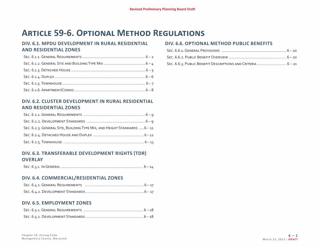
article 59-6. optional method regulations · chapter 59: zoning code 6 montgomery county, maryland...
TRANSCRIPT
C hap te r 59: Z o n i n g C o d e M o nt go m e r y C o unt y, Mar y l an d
6 – 1Mar c h 1 3, 201 3 | D R A F T
Revised Preliminary Planning Board Draft
Article 59-6. Optional Method RegulationsDIV. 6.1. MPDU DEVELOPMENT IN RURAL RESIDENTIAL AND RESIDENTIAL ZONES
Sec. 6.1.1. General Requirements ........................................................... 6 – 2
Sec. 6.1.2. General Site and Building Type Mix ....................................... 6 – 4
Sec. 6.1.3. Detached House ...................................................................... 6 – 5
Sec. 6.1.4. Duplex ..................................................................................... 6 – 6
Sec. 6.1.5. Townhouse .............................................................................. 6 – 7
Sec. 6.1.6. Apartment/Condo ................................................................... 6 – 8
DIV. 6.2. CLUSTER DEVELOPMENT IN RURAL RESIDENTIAL AND RESIDENTIAL ZONES
Sec. 6.2.1. General Requirements .......................................................... 6 – 9
Sec. 6.2.2. Development Standards ....................................................... 6 – 9
Sec. 6.2.3. General Site, Building Type Mix, and Height Standards .....6 – 11
Sec. 6.2.4. Detached House and Duplex ..................................................6 – 12
Sec. 6.2.5. Townhouse ................................................................................ 6 – 13
DIV. 6.3. TRANSFERABLE DEVELOPMENT RIGHTS (TDR) OVERLAY
Sec. 6.3.1. In General ............................................................................. 6 – 14
DIV. 6.4. COMMERCIAL/RESIDENTIAL ZONESSec. 6.4.1. General Requirements ........................................................6 – 17
Sec. 6.4.2. Development Standards .......................................................6 – 17
DIV. 6.5. EMPLOYMENT ZONESSec. 6.5.1. General Requirements ........................................................ 6 – 18
Sec. 6.5.2. Development Standards ...................................................... 6 – 18
DIV. 6.6. OPTIONAL METHOD PUBLIC BENEFITSSec. 6.6.1. General Provisions ............................................................. 6 – 20
Sec. 6.6.2. Public Benefit Overview ...................................................... 6 – 20
Sec. 6.6.3. Public Benefit Descriptions and Criteria ........................... 6 – 21
C hap te r 59: Z o n i n g C o d e M o nt go m e r y C o unt y, Mar y l an d
6 – 2D R A F T | Ma r c h 1 3, 201 3
Revised Preliminary Planning Board Draft
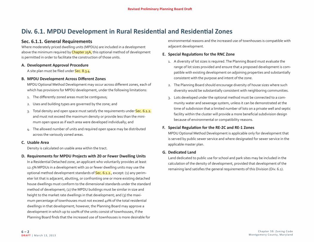
Sec. 6.1.1. General RequirementsWhere moderately priced dwelling units (MPDUs) are included in a development above the minimum required by Chapter 25A, this optional method of development is permitted in order to facilitate the construction of those units.
A. Development Approval ProcedureA site plan must be filed under Sec. 8.3.4.
B. MPDU Development Across Different Zones MPDU Optional Method Development may occur across different zones, each of which has provisions for MPDU development, under the following limitations:
1. The differently zoned areas must be contiguous;
2. Uses and building types are governed by the zone; and
3. Total density and open space must satisfy the requirements under Sec. 6.1.2. and must not exceed the maximum density or provide less than the mini-mum open space as if each area were developed individually; and
4. The allowed number of units and required open space may be distributed across the variously zoned areas.
C. Usable Area Density is calculated on usable area within the tract.
D. Requirements for MPDU Projects with 20 or Fewer Dwelling Units In a Residential Detached zone, an applicant who voluntarily provides at least 12.5% MPDUs in a development with 20 or fewer dwelling units may use the optional method development standards of Sec. 6.1.2., except: (1) any perim-eter lot that is adjacent, abutting, or confronting one or more existing detached house dwellings must conform to the dimensional standards under the standard method of development; (2) the MPDU buildings must be similar in size and height to the market rate dwellings in that development; and (3) the maxi-mum percentage of townhouses must not exceed 40% of the total residential dwellings in that development; however, the Planning Board may approve a development in which up to 100% of the units consist of townhouses, if the Planning Board finds that the increased use of townhouses is more desirable for
environmental reasons and the increased use of townhouses is compatible with adjacent development.
E. Special Regulations for the RNC Zone
1. A diversity of lot sizes is required. The Planning Board must evaluate the range of lot sizes provided and ensure that a proposed development is com-patible with existing development on adjoining properties and substantially consistent with the purpose and intent of the zone.
2. The Planning Board should encourage diversity of house sizes where such diversity would be substantially consistent with neighboring communities.
3. Lots developed under the optional method must be connected to a com-munity water and sewerage system, unless it can be demonstrated at the time of subdivision that a limited number of lots on a private well and septic facility within the cluster will provide a more beneficial subdivision design because of environmental or compatibility reasons.
F. Special Regulation for the RE-2C and RE-1 ZonesMPDU Optional Method Development is applicable only for development that is served by public sewer service and where designated for sewer service in the applicable master plan.
G. Dedicated LandLand dedicated to public use for school and park sites may be included in the calculation of the density of development, provided that development of the remaining land satisfies the general requirements of this Division (Div. 6.1).
Div. 6.1. MPDU Development in Rural Residential and Residential Zones

C hap te r 59: Z o n i n g C o d e M o nt go m e r y C o unt y, Mar y l an d
6 – 3Mar c h 1 3, 201 3 | D R A F T
Revised Preliminary Planning Board Draft
H. Building Types Allowed by ZoneBuilding types are allowed in Optional Method MPDU Development as follows:
5’
10’
30’
20’
40’
5’ 10’
30’
20’
40’
5’ 5’10’ 15’ 10’15’20’ 20’30’ 30’40’ 40’
Min % Build-To
100%
Buildable Area SetbackSetback
Min % Build-To
100%
Buildable Area SetbackSetbackDetachedHouse Duplex Townhouse Apartment/Condo
Rural Residential ZonesRural Neighborhood Cluster (RNC) A A A --Residential Detached ZonesResidential Estate - 2C (RE-2C) A A A --Residential Estate - 1 (RE-1) A A A --Residential - 200 (R-200) A A A --Residential - 90 (R-90) A A A --Residential - 60 (R-60) A A A --Residential - 40 (R-40) A A A --Residential Townhouse ZonesTownhouse Low Density (TLD) A A A --Townhouse Medium Density (TMD) A A A --Townhouse High Density (THD) A A A --
Residential Multi-Unit ZonesResidential Multi-Unit Low Density - 3 (R-30) A A A AResidential Multi-Unit Medium Density - 2 (R-20) A A A AResidential Multi-Unit High Density - 1 (R-10) A A A AKEY: A = Allowed to accommodate permitted, limited, and conditional uses -- = Not allowed
C hap te r 59: Z o n i n g C o d e M o nt go m e r y C o unt y, Mar y l an d
6 – 4D R A F T | Ma r c h 1 3, 201 3
Revised Preliminary Planning Board Draft
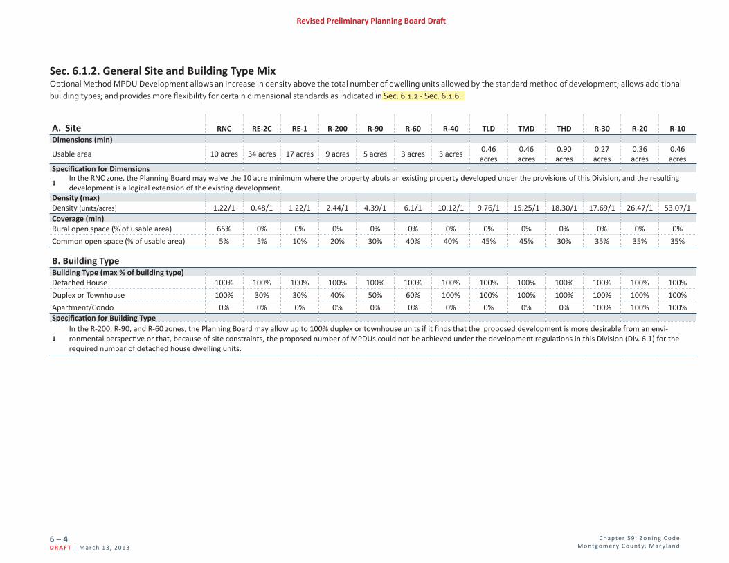
Sec. 6.1.2. General Site and Building Type MixOptional Method MPDU Development allows an increase in density above the total number of dwelling units allowed by the standard method of development; allows additional building types; and provides more flexibility for certain dimensional standards as indicated in Sec. 6.1.2 - Sec. 6.1.6.
A. Site RNC RE-2C RE-1 R-200 R-90 R-60 R-40 TLD TMD THD R-30 R-20 R-10Dimensions (min)
Usable area 10 acres 34 acres 17 acres 9 acres 5 acres 3 acres 3 acres0.46 acres
0.46 acres
0.90 acres
0.27 acres
0.36 acres
0.46 acres
Specification for Dimensions
1In the RNC zone, the Planning Board may waive the 10 acre minimum where the property abuts an existing property developed under the provisions of this Division, and the resulting development is a logical extension of the existing development.
Density (max)Density (units/acres) 1.22/1 0.48/1 1.22/1 2.44/1 4.39/1 6.1/1 10.12/1 9.76/1 15.25/1 18.30/1 17.69/1 26.47/1 53.07/1Coverage (min)Rural open space (% of usable area) 65% 0% 0% 0% 0% 0% 0% 0% 0% 0% 0% 0% 0%
Common open space (% of usable area) 5% 5% 10% 20% 30% 40% 40% 45% 45% 30% 35% 35% 35%
B. Building TypeBuilding Type (max % of building type)Detached House 100% 100% 100% 100% 100% 100% 100% 100% 100% 100% 100% 100% 100%
Duplex or Townhouse 100% 30% 30% 40% 50% 60% 100% 100% 100% 100% 100% 100% 100%
Apartment/Condo 0% 0% 0% 0% 0% 0% 0% 0% 0% 0% 100% 100% 100%Specification for Building Type
1In the R-200, R-90, and R-60 zones, the Planning Board may allow up to 100% duplex or townhouse units if it finds that the proposed development is more desirable from an envi-ronmental perspective or that, because of site constraints, the proposed number of MPDUs could not be achieved under the development regulations in this Division (Div. 6.1) for the required number of detached house dwelling units.
C hap te r 59: Z o n i n g C o d e M o nt go m e r y C o unt y, Mar y l an d
6 – 5Mar c h 1 3, 201 3 | D R A F T
Revised Preliminary Planning Board Draft
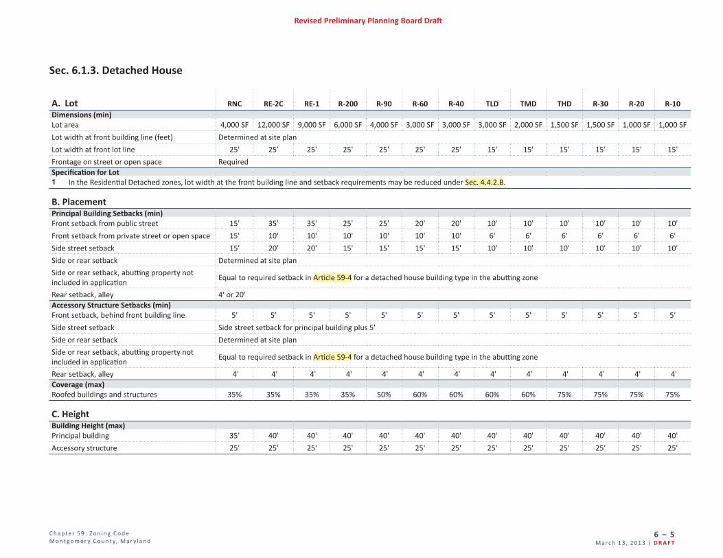
Sec. 6.1.3. Detached House
A. Lot RNC RE-2C RE-1 R-200 R-90 R-60 R-40 TLD TMD THD R-30 R-20 R-10Dimensions (min)Lot area 4,000 SF 12,000 SF 9,000 SF 6,000 SF 4,000 SF 3,000 SF 3,000 SF 3,000 SF 2,000 SF 1,500 SF 1,500 SF 1,000 SF 1,000 SF
Lot width at front building line (feet) Determined at site plan
Lot width at front lot line 25' 25' 25' 25' 25' 25' 25' 15' 15' 15' 15' 15' 15'
Frontage on street or open space RequiredSpecification for Lot1 In the Residential Detached zones, lot width at the front building line and setback requirements may be reduced under Sec. 4.4.2.B.
B. PlacementPrincipal Building Setbacks (min)Front setback from public street 15' 35' 35' 25' 25' 20' 20' 10' 10' 10' 10' 10' 10'
Front setback from private street or open space 15' 10' 10' 10' 10' 10' 10' 6' 6' 6' 6' 6' 6'
Side street setback 15' 20' 20' 15' 15' 15' 15' 10' 10' 10' 10' 10' 10'
Side or rear setback Determined at site plan
Side or rear setback, abutting property not included in application
Equal to required setback in Article 59-4 for a detached house building type in the abutting zone
Rear setback, alley 4' or 20' Accessory Structure Setbacks (min)Front setback, behind front building line 5' 5' 5' 5' 5' 5' 5' 5' 5' 5' 5' 5' 5'
Side street setback Side street setback for principal building plus 5'
Side or rear setback Determined at site plan
Side or rear setback, abutting property not included in application
Equal to required setback in Article 59-4 for a detached house building type in the abutting zone
Rear setback, alley 4' 4' 4' 4' 4' 4' 4' 4' 4' 4' 4' 4' 4'Coverage (max)Roofed buildings and structures 35% 35% 35% 35% 50% 60% 60% 60% 60% 75% 75% 75% 75%
C. HeightBuilding Height (max)Principal building 35' 40' 40' 40' 40' 40' 40' 40' 40' 40' 40' 40' 40'
Accessory structure 25' 25' 25' 25' 25' 25' 25' 25' 25' 25' 25' 25' 25'

C hap te r 59: Z o n i n g C o d e M o nt go m e r y C o unt y, Mar y l an d
6 – 6D R A F T | Ma r c h 1 3, 201 3
Revised Preliminary Planning Board Draft
Sec. 6.1.4. Duplex
A. Lot RNC RE-2C RE-1 R-200 R-90 R-60 R-40 TLD TMD THD R-30 R-20 R-10Dimensions (min)Lot area 3,500 SF 7,500 SF 4,500 SF 3,000 SF 2,000 SF 1,500 SF 1,500 SF 1,500 SF 1,000 SF 1,000 SF 1,000 SF 800 SF 800 SF
Lot width at front building line Determined at site plan
Lot width at front lot line 25' 25' 25' 25' 25' 25' 25' 15' 15' 15' 15' 15' 15'
Frontage on street or open space RequiredSpecification for Lot1 In the Residential Detached zones, lot width at the front building line and setback requirements may be reduced under Sec. 4.4.2.B.
B. PlacementPrincipal Building Setbacks (min)Front setback from public street 15' 35' 35' 25' 25' 20' 20' 10' 10' 10' 10' 10' 10'Front setback from private street or open space
15' 10' 10' 10' 10' 10' 10' 6' 6' 6' 6' 6' 6'
Side street setback 15' 20' 20' 15' 15' 15' 15' 10' 10' 10' 10' 10' 10'
Side or rear setback Determined at site planSide or rear setback, abutting property not included in application
Equal to required setback in Article 59-4 for a detached house building type in the abutting zone
Rear setback, alley 4' or 20'Accessory Structure Setbacks (min)Front setback, behind front building line 5' 5' 5' 5' 5' 5' 5' 5' 5' 5' 5' 5' 5'
Side street setback Side street setback for principal building plus 5'
Side or rear setback Determined at site planSide or rear setback, abutting property not included in application
Equal to required setback in Article 59-4 for a detached house building type in the abutting zone
Rear setback, alley 4' 4' 4' 4' 4' 4' 4' 4' 4' 4' 4' 4' 4'Coverage (max)Roofed buildings and structures 35% 35% 35% 35% 50% 60% 60% 60% 60% 75% 75% 75% 75%
C. HeightBuilding Height (max)Principal building 35' 40' 40' 40' 40'' 40'' 40'' 40' 40' 40' 40' 40' 40'
Accessory structure 25' 25' 25' 25' 25' 25' 25' 25' 25' 25' 25' 25' 25'

C hap te r 59: Z o n i n g C o d e M o nt go m e r y C o unt y, Mar y l an d
6 – 7Mar c h 1 3, 201 3 | D R A F T
Revised Preliminary Planning Board Draft
Sec. 6.1.5. Townhouse
A. Lot RNC RE-2C RE-1 R-200 R-90 R-60 R-40 TLD TMD THD R-30 R-20 R-10Dimensions (min)Lot area 1,500 SF 1,500 SF 1,500 SF 1,200 SF 1,200 SF 1,200 SF 1,200 SF 800 SF 800 SF 800 SF 800 SF 800 SF 800 SF
Lot width at front building line Determined at site plan
Lot width at front lot line 14' 14' 14' 14' 14' 14' 14' 14' 14' 14' 14' 14' 14'
Frontage on street or open space RequiredSpecification for Lot1 In the Residential Detached zones, lot width at the front building line and setback requirements may be reduced under Sec. 4.4.2.B.
B. PlacementPrincipal Building Setbacks (min)Front setback from public street 15' 35' 35' 25' 25' 20' 20' 10' 10' 10' 10' 10' 10'Front setback from private street or open space
15' 10' 10' 10' 10' 10' 10' 6' 6' 6' 6' 6' 6'
Side street setback 15' 20' 20' 15' 15' 15' 15' 10' 10' 10' 10' 10' 10'
Side or rear setback Determined at site planSide or rear setback, abutting property not included in application
Equal to required setback in Article 59-4 for a detached house building type in the abutting zone
Rear setback, alley 4' or 20'Accessory Structure Setbacks (min)Front setback, behind front building line 5' 5' 5' 5' 5' 5' 5' 5' 5' 5' 5' 5' 5'
Side street setback Side street setback for principal building plus 5'
Side or rear setback Determined at site planSide or rear setback, abutting property not included in application
Equal to required setback in Article 59-4 for a detached house building type in the abutting zone
Rear setback, alley 4' 4' 4' 4' 4' 4' 4' 4' 4' 4' 4' 4' 4'Coverage (max)Roofed buildings and structures 50% 50% 50% 50% 60% 60% 60% 60% 60% 75% 75% 75% 75%
C. HeightBuilding Height (max)Principal building 35' 40' 40' 40' 40' 40' 40' 40' 40' 40' 40' 40' 40'
Accessory structure 25' 25' 25' 25' 25' 25' 25' 25' 25' 25' 25' 25' 25'

C hap te r 59: Z o n i n g C o d e M o nt go m e r y C o unt y, Mar y l an d
6 – 8D R A F T | Ma r c h 1 3, 201 3
Revised Preliminary Planning Board Draft
Sec. 6.1.6. Apartment/Condo
A. Lot R-30 R-20 R-10Dimensions (min)Lot area 12,000 SF 16,000 SF 20,000 SF
Lot width at front lot line 50' 50' 50'
B. PlacementPrincipal Building Setbacks (min)Front setback from public street Determined at site plan
Side street setback Determined at site plan
Side or rear setback Determined at site plan
Side or rear setback, abutting property not included in applicationEqual to required setback in Article 59-4 for a detached house building type in the abutting zone and Sec. 4.1.6
Parking Setbacks (min)Front setback 30' 30' 30'
Side street setback 10' 10' 10'
Side or rear setback 0' 0' 0'
Side or rear setback, abutting property not included in applicationEqual to required setback in Article 59-4 for a detached house building type in the abutting zone and Sec. 4.1.6
Coverage (max)Roofed buildings and structures 18% 18% 12%
C. HeightBuilding Height (max)
Principal building35' and
Sec. 4.1.680' and
Sec. 4.1.6100' andSec. 4.1.6
Accessory structure 25' 25' 25'

C hap te r 59: Z o n i n g C o d e M o nt go m e r y C o unt y, Mar y l an d
6 – 9Mar c h 1 3, 201 3 | D R A F T
Revised Preliminary Planning Board Draft
Div. 6.2. Cluster Development in Rural Residential and Residential Zones C. Building Types Allowed by Zone
Building types are allowed in Optional Method Cluster Development as follows:
5’
10’
30’
20’
40’
5’ 10’
30’
20’
40’
5’ 5’10’ 15’ 10’15’20’ 20’30’ 30’40’ 40’
Min % Build-To
100%
Buildable Area SetbackSetback
Min % Build-To
100%
Buildable Area SetbackSetbackDetachedHouse Duplex Townhouse
Rural Residential ZonesRural Cluster (RC) A -- --
Residential Detached ZonesResidential Estate - 2C (RE-2C) A -- --Residential Estate - 1 (RE-1) A -- --Residential- 200 (R-200) A -- --Residential- 90 (R-90) A A AResidential - 60 (R-60) A A AKEY: A = Allowed to accommodate permitted, limited, and conditional uses -- = Not allowed
Sec. 6.2.2. Development Standards Optional method cluster development must comply with the requirements of Sec. 6.2.2.A-F.
A. Master Plan and Design Guidelines
1. Development must be substantially consistent with the recommendations of the applicable master plan.
2. Development must address any design guidelines approved by the Planning Board that implement the applicable master plan.
B. Cluster Development Across Different Zones Optional method cluster development may occur across different zones under the following limitations:
1. The differently zoned areas must be contiguous;
2. Uses and building types are governed by the zone; and
3. Total density and common open space must satisfy the requirements under Sec. 6.2.3 and must not exceed the maximum density or provide less than
Sec. 6.2.1. General Requirements The purpose of the cluster method of development is to provide an optional method of development that encourages the provision of community open space for ac-tive or passive recreation as well as the preservation and enhancement of natural resources. Optional Method Cluster Development provides for flexibility in lot layout and for variety in the types of residential buildings while preserving the same limita-tions on density of dwelling units per acre as normally permitted in the respective zone; protecting the character of the existing neighborhood; and providing open space for common use. In order to accomplish this purpose, certain changes in lot areas and dimensions and a greater variety of building types are allowed. The use of this method of development, and site plan approval for portions of such develop-
ment, are subject to approval by the Planning Board.
A. Development Approval Procedure A site plan must be filed under Sec. 8.3.4 for any development on a property with an approved sketch plan.
B. Community Water and Sewer In the Residential Detached zones, development under this method is prohibited and no building permit will be issued unless the resulting development will be connected to community water supply and sewerage systems, except that land in the RE-2C zone that is not served by community sewer may be developed under this method if it meets each of the following conditions:
1. A master plan specifically recommends cluster development with commu-nity water but not community sewer;
2. The resulting development will be connected to community water; and
3. The resulting development meets all of the requirements for individual sewerage systems outlined in the most recent County comprehensive water supply and sewerage systems plan and Executive Regulation No. 5-79, as amended, on individual water supply and sewage disposal systems.
C hap te r 59: Z o n i n g C o d e M o nt go m e r y C o unt y, Mar y l an d
6 – 10D R A F T | Ma r c h 1 3, 201 3
Revised Preliminary Planning Board Draft
the minimum common open space as if each area were developed individu-ally; and
4. The allowed number of units and required common open space may be distributed across the variously zoned areas.
C. Usable Area Density is calculated on usable area within the tract.
D. Dedicated LandLand dedicated to public use for a school or park site may be included in the calculation of the density of development; provided that development of the remaining land can be accomplished in compliance with the requirements of this Section (Sec. 6.2.2).
E. Special Regulations for the RC Zone
1. The plan of cluster development must show how scenic vistas are being preserved or enhanced, and reflect an arrangement that has considered the visual impact of the residential development on such vistas.
2. The Planning Board may refuse to approve the cluster method or a plan of cluster development if in its judgment:
a. Significant agricultural, farming, or similar activity would be jeopardized unduly through development under the cluster method;
b. The natural integrity of environmentally sensitive areas would be threat-ened due to the cluster development; or
c. Significant scenic vistas would be lost, obliterated, or substantially di-minished in value due to the cluster development.
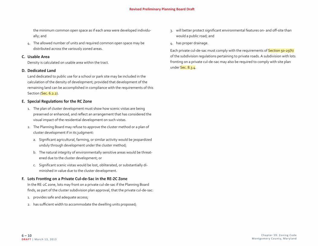
F. Lots Fronting on a Private Cul-de-Sac in the RE-2C ZoneIn the RE-2C zone, lots may front on a private cul-de-sac if the Planning Board finds, as part of the cluster subdivision plan approval, that the private cul-de-sac:
1. provides safe and adequate access;
2. has sufficient width to accommodate the dwelling units proposed;
3. will better protect significant environmental features on- and off-site than would a public road; and
4. has proper drainage.
Each private cul-de-sac must comply with the requirements of Section 50-25(h) of the subdivision regulations pertaining to private roads. A subdivision with lots fronting on a private cul-de-sac may also be required to comply with site plan under Sec. 8.3.4.
C hap te r 59: Z o n i n g C o d e M o nt go m e r y C o unt y, Mar y l an d
6 – 11Mar c h 1 3, 201 3 | D R A F T
Revised Preliminary Planning Board Draft
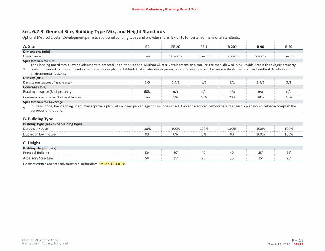
Sec. 6.2.3. General Site, Building Type Mix, and Height Standards Optional Method Cluster Development permits additional building types and provides more flexibility for certain dimensional standards.
A. Site RC RE-2C RE-1 R-200 R-90 R-60Dimensions (min)Usable area n/a 50 acres 50 acres 5 acres 5 acres 5 acresSpecification for Site
1The Planning Board may allow development to proceed under the Optional Method Cluster Development on a smaller site than allowed in A1 Usable Area if the subject property is recommended for cluster development in a master plan or if it finds that cluster development on a smaller site would be more suitable than standard method development for environmental reasons.
Density (max)Density (units/acres of usable area) 1/5 0.4/1 1/1 2/1 3.6/1 5/1Coverage (min)Rural open space (% of property) 60% n/a n/a n/a n/a n/a
Common open space (% of usable area) n/a 5% 10% 20% 30% 40%Specification for Coverage
1 In the RC zone, the Planning Board may approve a plan with a lower percentage of rural open space if an applicant can demonstrate that such a plan would better accomplish the purposes of the zone.
B. Building TypeBuilding Type (max % of building type)Detached House 100% 100% 100% 100% 100% 100%
Duplex or Townhouse 0% 0% 0% 0% 100% 100%
C. HeightBuilding Height (max)Principal Building 50' 40' 40' 40' 35' 35'
Accessory Structure 50' 25' 25' 25' 25' 25'
Height restrictions do not apply to agricultural buildings. See Sec. 4.1.4.D.3.e

C hap te r 59: Z o n i n g C o d e M o nt go m e r y C o unt y, Mar y l an d
6 – 12D R A F T | Ma r c h 1 3, 201 3
Revised Preliminary Planning Board Draft
Sec. 6.2.4. Detached House and Duplex
A. Lot RC RE-2C RE-1 R-200 R-90 R-60Dimensions (min)Lot area for detached house 40,000 SF 15,000 SF 12,000 SF 9,000 SF 5,000 SF 3,000 SF
Lot area for duplex n/a 7,500 SF 6,000 SF 4,500 SF 2,500 SF 1,500 SF
Lot width at front building line 125' n/a n/a n/a n/a n/a
Lot width at front lot line 25' 25' 25' 25' 25' 25'
Frontage on street or open space RequiredSpecification for Lot1 In the Residential Detached zones, lot width at the front building line and setback requirements may be reduced under Sec. 4.4.2.B.
B. PlacementPrincipal Building Setbacks (min)Front setback from public street 50' 35' 35' 25' 25' 20'
Front setback from private street or open space 50' 10' 10' 10' 10' 10'
Side street setback 50' 20' 20' 15' 15' 15'
Side or rear setback Determined at site plan
Side setback, abutting property not included in application 17'Equal to required setback in Article 59-4 for a detached house building type in the abutting zone
Rear setback, abutting property not included in application 35' 50' 50' 40' 30' 30'
Rear setback, alley 4' or 20'Accessory Structure Setbacks (min)Front setback 80' 80' 80' 65' 60' 60'
Side street setback Side street setback for principal building plus 5'
Side or rear setback Determined at site plan
Side or rear setback, abutting property not included in application Equal to required setback in Article 59-4 for a detached house building type in the abutting zone
Rear setback, alley 4' 4' 4' 4' 4' 4'Specifications for Principal Building and Accessory Structure Setbacks1 In the RC zone, the front setback and side street setback must consist of any scenic setback indicated on a master plan or 50 feet, whichever is greater.
2 In addition to the front setback minimum, accessory structures must be located behind the rear building line of the principal building.
3 In the RC, RE-2C, and RE-1 zones, accessory structures on a lot or parcel abutting a national historical park must be set back a minimum of 200' from the national historical park unless the accessory structure is exempted under Sec. 7.5.3.B.5.
4 In the R-90 and R-60 zones, for accessory structures with a height greater than 15', the minimum side and rear setback must be increased by 2' for each foot of height in excess of 15'.
5 In the R-90 and R-60 zones, for accessory structures with a length along a rear or side property line which has a linear dimension greater than 24', the minimum side or rear setback must be increased at a ratio of 2' for every 2' that the dimension exceeds 24 linear feet. Swimming pools are exempt from this requirement.
Coverage (max)Roofed buildings and structures 10% 15% 15% 25% 30% 35%Specification for Coverage
1In the RC zone, the total impervious surface area of any proposed preliminary plan must not exceed any impervious surface area limit recommended by the master plan. A project which has had a preliminary plan approved before December 24, 2012 may be built or altered without a limit on impervious surface area. A preliminary plan approved before Decem-ber 24, 2012 may be built or altered if the coverage of any lot is 10% of the lot or less, without a limit on total impervious surface area.

C hap te r 59: Z o n i n g C o d e M o nt go m e r y C o unt y, Mar y l an d
6 – 13Mar c h 1 3, 201 3 | D R A F T
Revised Preliminary Planning Board Draft
Sec. 6.2.5. Townhouse
A. Lot R-90 R-60Dimensions (min)Lot area 1,500 SF 1,500 SF
Lot width at front lot line 16' 14'
Average frontage of a group of attached townhouses Determined at site planSpecification for Lot1 In the Residential Detached zones, lot width at the front building line and setback requirements may be reduced under Sec. 4.4.2.B.
B. PlacementPrincipal Building Setbacks (min)Front setback from public street 25' 20'
Front setback from private street or open space 10' 10'
Side street setback 15' 15'
Side or rear setback Determined at site planSide or rear setback, abutting property not included in application 30' 30'Rear setback, alley 4' or 20'Accessory Structure Setbacks (min)Front setback 60' 60'
Side street setback Side street setback for principal building plus 5'
Side or rear setback Determined at site plan
Side or rear setback, abutting property not included in applicationEqual to required setback in Article 59-4 for a detached house building type in the abutting zone
Rear setback, alley 4' 4'Specifications for Accessory Structure Setbacks1 In addition to the front setback minimum, accessory structures must be located behind the rear building line of the principal building.
2 For accessory structures with a height greater than 15', the minimum side and rear setback must be increased by 2' for each foot of height in excess of 15'.
3 For accessory structures with a length along a rear or side property line which has a linear dimension greater than 24', the minimum side or rear setback must be increased at a ratio of 2' for every 2' that the dimension exceeds 24 linear feet. Swimming pools are exempt from this specification.
Coverage (max)Roofed buildings and structures 75% 75%
C. FormMassing (max)Number of units permitted in any one row 8 10
C hap te r 59: Z o n i n g C o d e M o nt go m e r y C o unt y, Mar y l an d
6 – 14D R A F T | Ma r c h 1 3, 201 3
Revised Preliminary Planning Board Draft
Div. 6.3. Transferable Development Rights (TDR) Overlay limit the future construction of detached houses on a property in the AR zone to the total number of development rights established by the zoning of the property minus all development rights previously transferred under this Section (Sec. 6.3.1), the number of development rights to be transferred by the instant transaction, and the number of existing detached houses on the property.
2. The transfer of development rights must be recorded in the land records of the County.
3. Prior to recordation of a final record plat for a subdivision using transferred development rights, an easement to the Montgomery County Government limiting future construction of dwellings on a property in the AR zone by the number of development rights received must be recorded among the land records of the County.
4. A final record plat for a subdivision using transferred development rights must contain a statement including the development proposed, the zoning classification of the property, the number of development rights used, and a notation of the recordation of the conveyance as required by Sec. 6.3.1.
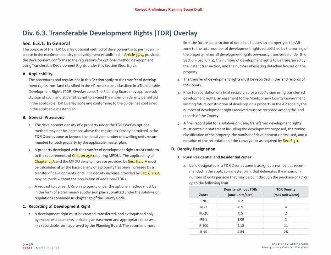
D. Density Designation
1. Rural Residential and Residential Zones:
a. Land designated in a TDR Overlay zone is assigned a number, as recom-mended in the applicable master plan, that delineates the maximum number of units per acre that may be built through the purchase of TDRs up to the following limit:
Zones
Density without TDRs
(max units/acre)
TDR Density
(max units/acre)
RNC 0.2 1
RE-2 0.5 4
RE-2C 0.5 2
RE-1 1.09 2
R-200 2.18 11
R-90 4.84 28
Sec. 6.3.1. In GeneralThe purpose of the TDR Overlay optional method of development is to permit an in-crease in the maximum density of development established in Article 59-4, provided the development conforms to the regulations for optional method development using Transferable Development Rights under this Section (Sec. 6.3.1).
A. ApplicabilityThe procedures and regulations in this Section apply to the transfer of develop-ment rights from land classified in the AR zone to land classified in a Transferable Development Rights (TDR) Overlay zone. The Planning Board may approve sub-division of such land at densities not to exceed the maximum density permitted in the applicable TDR Overlay zone and conforming to the guidelines contained in the applicable master plan.
B. General Provisions
1. The development density of a property under the TDR Overlay optional method may not be increased above the maximum density permitted in the TDR Overlay zone or beyond the density or number of dwelling units recom-mended for such property by the applicable master plan.
2. A property developed with the transfer of development rights must conform to the requirements of Chapter 25A requiring MPDUs. The applicability of Chapter 25A and the MPDU density increase provided by Sec. 6.1.2.A must be calculated after the base density of a property has been increased by a transfer of development rights. The density increase provided by Sec. 6.1.2.A may be made without the acquisition of additional TDRs.
3. A request to utilize TDRs on a property under the optional method must be in the form of a preliminary subdivision plan submitted under the subdivision regulations contained in Chapter 50 of the County Code.
C. Recording of Development Right
1. A development right must be created, transferred, and extinguished only by means of documents, including an easement and appropriate releases, in a recordable form approved by the Planning Board. The easement must

C hap te r 59: Z o n i n g C o d e M o nt go m e r y C o unt y, Mar y l an d
6 – 15Mar c h 1 3, 201 3 | D R A F T
Revised Preliminary Planning Board Draft
Zones
Density without TDRs
(max units/acre)
TDR Density
(max units/acre)
R-60 7.26 28
R-30 14.5 40
R-20 21.7 50
R-10 43.5 100
b. TDR Overlay zones are delineated on the zoning map as the overlay zone symbol (TDR) followed by the TDR density designation (1 through 100,
including fractions), [TDR-#].
2. Commercial/Residential and Employment Zones:
a. Optional method development in a TDR Overlay zone must use TDRs. TDRs must be purchased as recommended by the master plan or, if no recommendation is made, at least 5 public benefit points must be pro-vided through the purchase of TDRs, under Div. 6.6.
b. TDR Overlay zones are delineated as the overlay zone symbol (TDR) on the zoning map.
E. Calculation of TDRs Required in the Rural Residential or Residential ZonesDevelopment using TDRs must include at least two-thirds of the number of development rights designated on the zoning map unless the Planning Board finds that for environmental or compatibility reasons a lower density is more appropriate.
1. In the Rural Residential and Residential zones, the following building types require a minimum percent of total units indicated, and where applicable a maximum allowed (noted in parentheses). In addition, the minimum amount of common open space required is indicated:
TDR Density
Designation
Size of
Development
Building Type
(minimum required as a percentage of total units)
Common
Open
Space
(min)Detached
House
Duplex Townhouse Apartment/
Condo
1 Any size 100% 0% 0% Not permitted 0%
2 Any size 100% 0% 0% Not permitted 0%
3-5< 800 units 30% 0% 0% Not permitted 35%
800+ units 30% 0% 0% 0% (20% max) 35%
6-10< 200 units 15% 0% 0% Not permitted 40%
200+ units 15% 0% 0% 0% (35% max) 40%
11-15
< 200 units 0% 0% 0% 0% 50%
200+ units 0% 0% 0%35%
(60% max)50%
16-28
< 200 units 0% 0% 0% 0% 50%
200+ units 0% 0% 0%25%
(60% max)50%
> 28 Any size 0% 0% 0% 25% 50%
a. The apartment/condo building type is permitted only where specifically recommended in the area master plan for the receiving area. Where the minimum percentage requirement would yield a total of 150 units or fewer, this requirement does not apply, and no such units are required. Where the minimum percentage would yield 151 units or greater, the full number must be required except where the Planning Board finds other-wise, see Sec. 6.3.1.B.3.c.
b. A duplex or townhouse building type may be substituted for all or part of the apartment/condo requirement.
c. An apartment/condo building type is limited to a maximum building height of 40 feet. The height limit may be waived upon a finding by the Planning Board that a proposed development can achieve greater com-patibility with adjacent development than would result from adherence to the standards.

C hap te r 59: Z o n i n g C o d e M o nt go m e r y C o unt y, Mar y l an d
6 – 16D R A F T | Ma r c h 1 3, 201 3
Revised Preliminary Planning Board Draft
2. Each single TDR purchased allows the construction of the following number of units up to the TDR density designation:
a. In a Metro Station Policy Area:
i. 2 detached houses;
ii. 2 units in a duplex building type;
iii. 2 units in a townhouse building type; or
iv. 3 units in an apartment/condo building type.
b. In a Non-Metro Station Policy Area:
i. one detached house unit;
ii. one unit in a duplex building type;
iii. one unit in a townhouse building type; or
iv. 2 units in an apartment/condo building type.
3. The Planning Board may waive the minimum required or maximum allowed number of units of a particular building type if it finds that for environmental or compatibility reasons a different mix of building types is appropriate.
F. Development StandardsThe following table indicates the required development standards for each TDR density designation:
TDR Density Designation
Development Standards
1
In a Rural Residential zone, same as for a detached house building
type under standard method in the RNC zone, see Div. 4.3
In a Residential zone, same as for a detached house building type
under standard method in the RE-1 zone, see Div. 4.4
2Same as for a detached house building type under standard
method in the R-200, see Div. 4.4
3-5May utilize the R-60 Optional Method MPDU Development
standards, see Div. 6.1
6 or more Determined at site plan
G. Development with Moderately Priced Dwelling Units
1. Any property developed under this Section (Sec. 6.3.1) must conform to the requirements of Chapter 25A.
2. Any density bonus allowed under Chapter 25A is calculated after the base density of the property has been increased under this Section (Sec. 6.3.1)through TDRs.
3. In a Rural Residential or Residential zone, development using TDRs and pro-viding MPDUs above 12.5% must follow the requirements under Div. 6.1.
H. Additional FindingsIn addition to the findings required for approval of a site plan under Sec. 8.3.4 for projects developed under this Division (Div. 6.3), the Planning Board must find that the proposed development provides an appropriate range of housing types that takes advantage of existing topography and environmental features and achieves a mutually compatible relationship between the proposed develop-ment and adjoining land uses.

C hap te r 59: Z o n i n g C o d e M o nt go m e r y C o unt y, Mar y l an d
6 – 17Mar c h 1 3, 201 3 | D R A F T
Revised Preliminary Planning Board Draft
Div. 6.4. Commercial/Residential ZonesSec. 6.4.1. General Requirements
A. Procedure for Approval A sketch plan must be approved under Sec. 8.3.3. A site plan must be approved under Sec. 8.3.4. for any development on a property with an approved sketch plan.
B. Public Benefit Points and Categories
1. Public benefits under Div. 6.6 must be provided as follows:
Zone Site Size Public Benefit
Points (min)
Number of Benefit
Categories (min)
CRT
< 10,000 SF OR with < 1.5 max FAR
25 2
≥ 10,000 SF OR with ≥ 1.5 max FAR
50 3
CR
< 10,000 SF OR with < 1.5 max FAR
50 3
≥ 10,000 SF OR with ≥ 1.5 max FAR
100 4
2. In the CR zone, the purchase of BLTs is required under Sec. 6.6.2.F.1.a.
C. Master Plan and Design Guidelines
1. Development must be substantially consistent with the recommendations of the applicable master plan.
2. Development must comply with any design guidelines approved by the Plan-ning Board.
D. Building Type All building types allowed under Div. 4.5 are allowed in the CRT and CR zones under optional method development.
E. Compatibility Development StandardsDevelopment must satisfy the compatibility development standards under Sec. 4.1.6.
Sec. 6.4.2. Development Standards
A. Open Space
1. Open space must be provided based on the lot area and number of frontages as described in the following table. The open space must satisfy the criteria in Div. 7.3.
Lot Area # of Existing, Proposed, and Master-Planned Right-of-Way
Frontages 1 2 3 4 or more
% of Site Required to be Dedicated for Open Space
≤ 0.50 acres 0% 0% 0% 5%
0.51 to 1.00 acres 0% 0% 5% 10%
1.01 to 3.00 acres 0% 5% 10% 10%
3.01 to 6.00 acres 5% 10% 10% 10%
≥ 6.01 acres 10% 10% 10% 10%
2. In a development with townhouse, apartment/condo, multi use, or general building types, open space is calculated on the net site area minus any area used for detached house and duplex unit lots.
3. Open space for the townhouse building type is common open space and for other buildings is public open space under Div. 7.3.
B. Lot and Density
1. Lot standards for detached house, duplex and townhouse building types are determined by the site plan.
2. The maximum total, nonresidential, and residential FARs are established by the mapped zone.
C. PlacementSetbacks for principal buildings, accessory structures, and parking are estab-lished by the site plan.
D. HeightThe maximum height is established by the mapped zone.
E. FormForm standards are established by the site plan and must address, at a mini-mum, transparency, blank walls, and active entrances.
C hap te r 59: Z o n i n g C o d e M o nt go m e r y C o unt y, Mar y l an d
6 – 18D R A F T | Ma r c h 1 3, 201 3
Revised Preliminary Planning Board Draft
Div. 6.5. Employment ZonesSec. 6.5.1. General Requirements
A. Procedure for Approval A sketch plan must be approved under Sec. 8.3.3. A site plan must be approved under Sec. 8.3.4. for any development on a property with an approved sketch plan.
B. Public Benefit Points and Categories
1. Public benefits under Div. 6.6. must be provided as follows:
Zone Site Size Public Benefit
Points (min)
Number of Benefit
Categories (min)
LSC
< 10,000 SF OR with < 1.5 max FAR
15 1
≥ 10,000 SF OR with ≥ 1.5 max FAR
30 2
EOF
< 10,000 SF OR with < 1.5 max FAR
30 2
≥ 10,000 SF OR with ≥ 1.5 max FAR
60 3
2. In the LSC zone, the purchase of BLTs is required under Sec. 6.6.2.F.1.b.
C. Master Plan and Design Guidelines
1. Development must be substantially consistent with the recommendations of the applicable master plan.
2. Development must comply with any design guidelines approved by the Plan-ning Board.
D. Building Type All building types allowed under Div. 4.6. are allowed in the LSC and EOF zones
under optional method development.
E. Compatibility Development StandardsDevelopment must satisfy the compatibility development standards under Sec. 4.1.6.
Sec. 6.5.2. Development Standards
A. Open Space
1. Open space must be provided based on the lot area and number of frontages as described in the following table. The required open space must satisfy the criteria in Div. 7.3.
Lot Area # of Existing, Proposed, and Master-Planned Right-of-Way
Frontages 1 2 3 4 or more
% of Site Required to be Dedicated for Open Space
≤ 0.50 acres 0% 0% 0% 5%
0.51 to 1.00 acres 0% 0% 5% 10%
1.01 to 3.00 acres 0% 5% 10% 10%
3.01 to 6.00 acres 5% 10% 10% 10%
≥ 6.01 acres 10% 10% 10% 10%
2. In a development with townhouse, apartment/condo, multi use or general building types, open space is calculated on the site area minus any area used for detached house and duplex unit lots.
3. Open space for the townhouse building type is common open space and for other buildings is public open space under Div. 7.3.
B. Lot and Density
1. Lot standards for detached house, duplex and townhouse building types are established by the site plan.
2. The maximum density is established by the mapped zone.
3. Gross floor area of all Household Living uses in an application must not exceed 30% of maximum allowed FAR.
4. For tracts larger than 5 acres:
a. A minimum of 40% of the gross floor area proposed must be for Life Sciences and related uses. The proposed gross floor area used for the purpose of calculating the minimum percentage of Life Sciences uses

C hap te r 59: Z o n i n g C o d e M o nt go m e r y C o unt y, Mar y l an d
6 – 19Mar c h 1 3, 201 3 | D R A F T
Revised Preliminary Planning Board Draft
excludes: (1) Hospitals and the Hospital’s accessory uses; and (2) educa-tional facilities.
b. A maximum of 10% of the gross floor area proposed may be for Retail/Service Establishment; however, if the Planning Board finds that unique circumstances are present and the area would be enhanced by additional retail activity, then a maximum of 15% of the gross floor area proposed may be used for Retail/Service Establishment.
5. Any area used exclusively for mechanical equipment is excluded from the maximum density calculation, and any area excluded from this calculation that exceeds the FAR of the zone may not be used for any other purpose. The total area of any partial floors or stories excluded from the maximum density calculation must not exceed the gross floor area of any full floor of the building.
C. PlacementSetbacks for principal buildings, accessory structures, and parking are estab-lished by the site plan.
D. HeightThe maximum height is established by the mapped zone.
E. FormForm standards are established by the site plan and must address, at a mini-mum, transparency, blank walls, and active entrances.
C hap te r 59: Z o n i n g C o d e M o nt go m e r y C o unt y, Mar y l an d
6 – 20D R A F T | Ma r c h 1 3, 201 3
Revised Preliminary Planning Board Draft
Div. 6.6. Optional Method Public BenefitsSec. 6.6.1. General Provisions
A. Public Benefit Categories
1. Public benefits must be provided that enhance or contribute to the objec-tives of the zone among the following categories:
a. Major Public Facilities;
b. Transit Proximity;
c. Connectivity and Mobility;
d. Diversity of Uses and Activities;
e. Quality Building and Site Design; and
f. Protection and Enhancement of the Natural Environment.
2. Section 6.6.2. indicates the individual public benefits that may be accepted in each of these categories in each zone.
B. General Public Benefit Considerations Granting points as a public benefit for any amenity or project feature otherwise required by law is prohibited. In approving any incentive FAR based on the provi-sion of public benefits, the Planning Board must consider:
1. the recommendations and objectives of the applicable master plan;
2. the CR Zone Incentive Density Implementation Guidelines;
3. any design guidelines adopted for the applicable master plan area;
4. the size and configuration of the site;
5. the relationship of the site to adjacent properties;
6. the presence or lack of similar public benefits nearby; and
7. enhancements beyond the elements listed in an individual public benefit that increase public access to, or enjoyment of, the benefit.
C. Public Benefit Implementation Guidelines The Planning Board must adopt, publish, and maintain guidelines that detail the standards and requirements for public benefits. The guidelines must:
1. be consistent with the objectives of this Division (Div. 6.6);
2. be in addition to any standards, requirements, or rules of incentive density
calculation included in this Division (Div. 6.6), but may not conflict with those provisions; and
3. only allow incentive FAR for those public benefits listed in Sec. 6.6.3.
Sec. 6.6.2. Public Benefit OverviewThe following public benefits may be accepted under optional method develop-ment:
A. Major Public Facility
B. Transit Proximity
C. Connectivity and Mobility
1. Advance Dedication
2. Minimum Parking
3. Neighborhood Services
4. Public Parking
5. Through-Block Connection
6. Transit Access or Streetscape Improvement
7. Trip Mitigation
8. Way Finding
D. Diversity of Uses and Activities
1. Adaptive Buildings
2. Affordable Housing
3. Care Centers
4. Dwelling Unit Mix
5. Enhanced Accessibility for the Disabled
6. Enhanced Visitability for Seniors/Disabled
7. Live/Work
8. Small Business Opportunity
9. Workforce Housing

C hap te r 59: Z o n i n g C o d e M o nt go m e r y C o unt y, Mar y l an d
6 – 21Mar c h 1 3, 201 3 | D R A F T
Revised Preliminary Planning Board Draft
E. Quality Building and Site Design
1. Architectural Elevations
2. Enhanced Recreation Facilities
3. Exceptional Design
4. Historic Resource Protection
5. Public Art
6. Public Open Space
7. Structured Parking
8. Tower Step-Back
F. Protection and Enhancement of the Natural Environment
1. Building Lot Terminations
2. Building Reuse
3. Cool Roof
4. Energy Conservation
5. Energy Generation
6. Habitat Preservation and Restoration
7. Recycling Facility Plan
8. Transferable Development Rights
9. Tree Canopy
10. Vegetated Area
11. Vegetated Roof
12. Vegetated Wall
Sec. 6.6.3. Public Benefit Descriptions and Criteria
A. Major Public Facilities
1. Major public facilities include, but are not limited to, such facilities as schools, libraries, recreation centers, parks, County service centers, bike
share stations, public transportation or utility upgrades, or other resources delineated in an applicable master plan. Major public facilities provide public services at convenient locations where increased density creates a greater need for civic uses and greater demands on public infrastructure.
2. Where a proposed major public facility is not recommended in the applicable master plan, the Planning Board must find that the facility or improvement provides the community with a resource that is at least as beneficial as other major public facilities recommended in the applicable master plan. Additionally, any infrastructure upgrade may only receive incentive density for improvements beyond those required by any applicable adequate public facilities requirement to complete the proposed development.
3. Due to their significance in placemaking, the Planning Board may approve incentive FAR for the conveyance of a site or floor area for the construc-tion of or making a partial or full payment for a major public facility that is accepted for use or operation by an appropriate public agency, community association, or nonprofit organization.
4. Up to the following number of points may be awarded provided the require-ments of Sec. 6.6.3.A.3 are met:
a. 20 points in an LSC zone;
b. 40 points in an EOF or CRT zone; and
c. 70 points in a CR zone.
B. Transit Proximity
1. Development near transit facilities encourages greater use of transit, controls sprawl, and reduces vehicle miles traveled, congestion, and carbon emissions, and is eligible for incentive density.
2. Transit proximity points are granted for proximity to existing or master planned transit stops based on transit service level and CRT, CR, LSC, and EOF zones.
a. Transit proximity is categorized in 3 levels:
C hap te r 59: Z o n i n g C o d e M o nt go m e r y C o unt y, Mar y l an d
6 – 22D R A F T | Ma r c h 1 3, 201 3
Revised Preliminary Planning Board Draft
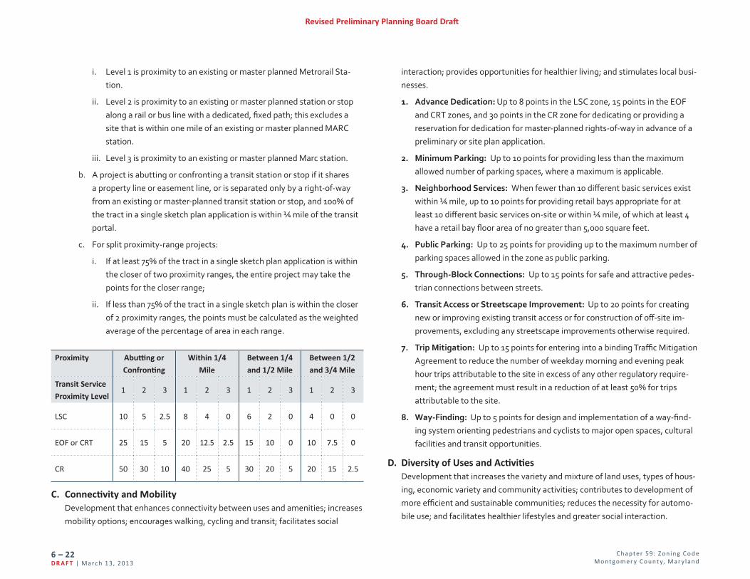
i. Level 1 is proximity to an existing or master planned Metrorail Sta-tion.
ii. Level 2 is proximity to an existing or master planned station or stop along a rail or bus line with a dedicated, fixed path; this excludes a site that is within one mile of an existing or master planned MARC station.
iii. Level 3 is proximity to an existing or master planned Marc station.
b. A project is abutting or confronting a transit station or stop if it shares a property line or easement line, or is separated only by a right-of-way from an existing or master-planned transit station or stop, and 100% of the tract in a single sketch plan application is within ¼ mile of the transit portal.
c. For split proximity-range projects:
i. If at least 75% of the tract in a single sketch plan application is within the closer of two proximity ranges, the entire project may take the points for the closer range;
ii. If less than 75% of the tract in a single sketch plan is within the closer of 2 proximity ranges, the points must be calculated as the weighted average of the percentage of area in each range.
Proximity Abutting or
Confronting
Within 1/4
Mile
Between 1/4
and 1/2 Mile
Between 1/2
and 3/4 Mile
Transit Service
Proximity Level1 2 3 1 2 3 1 2 3 1 2 3
LSC 10 5 2.5 8 4 0 6 2 0 4 0 0
EOF or CRT 25 15 5 20 12.5 2.5 15 10 0 10 7.5 0
CR 50 30 10 40 25 5 30 20 5 20 15 2.5
C. Connectivity and Mobility Development that enhances connectivity between uses and amenities; increases mobility options; encourages walking, cycling and transit; facilitates social
interaction; provides opportunities for healthier living; and stimulates local busi-nesses.
1. Advance Dedication: Up to 8 points in the LSC zone, 15 points in the EOF and CRT zones, and 30 points in the CR zone for dedicating or providing a reservation for dedication for master-planned rights-of-way in advance of a preliminary or site plan application.
2. Minimum Parking: Up to 10 points for providing less than the maximum allowed number of parking spaces, where a maximum is applicable.
3. Neighborhood Services: When fewer than 10 different basic services exist within ¼ mile, up to 10 points for providing retail bays appropriate for at least 10 different basic services on-site or within ¼ mile, of which at least 4 have a retail bay floor area of no greater than 5,000 square feet.
4. Public Parking: Up to 25 points for providing up to the maximum number of parking spaces allowed in the zone as public parking.
5. Through-Block Connections: Up to 15 points for safe and attractive pedes-trian connections between streets.
6. Transit Access or Streetscape Improvement: Up to 20 points for creating new or improving existing transit access or for construction of off-site im-provements, excluding any streetscape improvements otherwise required.
7. Trip Mitigation: Up to 15 points for entering into a binding Traffic Mitigation Agreement to reduce the number of weekday morning and evening peak hour trips attributable to the site in excess of any other regulatory require-ment; the agreement must result in a reduction of at least 50% for trips attributable to the site.
8. Way-Finding: Up to 5 points for design and implementation of a way-find-ing system orienting pedestrians and cyclists to major open spaces, cultural facilities and transit opportunities.
D. Diversity of Uses and Activities Development that increases the variety and mixture of land uses, types of hous-ing, economic variety and community activities; contributes to development of more efficient and sustainable communities; reduces the necessity for automo-bile use; and facilitates healthier lifestyles and greater social interaction.

C hap te r 59: Z o n i n g C o d e M o nt go m e r y C o unt y, Mar y l an d
6 – 23Mar c h 1 3, 201 3 | D R A F T
Revised Preliminary Planning Board Draft
1. Adaptive Buildings: Up to 10 points for constructing commercial or mixed use buildings with minimum floor-to-floor heights of at least 15 feet on any floor that meets grade and 12 feet on all other floors. Internal structural systems must be able to accommodate various types of use with only minor modifications.
2. Affordable Housing
a. Up to 40 points for providing MPDUs above the 12.5% minimum required under Chapter 25A.
b. Points are calculated as follows:
i. 12 points are granted for every 1% of MPDUs greater than 12.5%. Any fraction of 1% increase in MPDUs entitles the applicant to an equal fraction of 12 points.
ii. Above 15% of MPDUs, each 1% of additional MPDUs entitles the ap-plicant to an additional 2 benefit points. Any fraction of 1% increase in MPDUs entitles the applicant to an equal fraction of 2 points.
iii. In any case, for density and points to be awarded, at least one more MPDU than would be required at 12.5% must be provided to take advantage of the MPDU optional method or points in any zone.
c. The gross floor area of any MPDUs provided above 12.5% is exempt from the calculation of FAR.
3. Care Centers: Up to 20 points for constructing a child, teen, or adult day care facility accommodating at least 15 users in accordance with state stan-dards.
4. Dwelling Unit Mix: Up to 10 points for integrating a mix of residential mar-ket-rate unit types with at least 7.5% efficiency units, 8% one- and two-bed-room units and 5% three- or more bedroom units; the proportional number of MPDUs for each unit type must satisfy the requirements of Chapter 25A.
5. Enhanced Accessibility for Seniors or the Disabled: Up to 15 points for constructing dwelling units with interiors that satisfy American National Standards Institute A117.1 Residential Type A standards or an equivalent County standard.
6. Enhanced Visitability for Seniors or the Disabled: Up to 15 points for
constructing dwelling units in accordance with ANSI A117.1, Type C, Visitable Unit, each of which has a kitchen, dining area, living area, full bathroom, and bedroom on the accessible level.
7. Live/Work: Up to 10 points for developments of up to 2.0 FAR total allowed density that provide at least 3 units or, for developments allowed greater than 2.0 FAR, 10% of the total unit count as live/work units.
8. Small Business Opportunities: Up to 20 points for providing on-site space for small, neighborhood-oriented businesses.
9. Workforce Housing: Up to 20 points for providing workforce housing under Chapter 25B at a rate of 2 points for each percentage of the total units, excluding MPDUs.
E. Quality Building and Site Design High quality design is especially important in urban, integrated-use settings to ensure that buildings and uses are visually compatible with each other and adja-cent communities and to provide a harmonious pattern of development. Due to increased density in these settings, buildings tend to be highly visible and high quality design helps attract residents, patrons and businesses to these areas. Location, height, massing, façade treatments and ornamentation of buildings all affect sense of place, orientation and the perception of comfort and con-venience. The quality of the built environment affects light, shadow, wind and noise, as well as the functional and economic value of property.
1. Architectural Elevations: Up to 20 points for providing elevations of archi-tectural facades and agreeing to be bound by particular elements of design that exceed the requirements of this Division (Div. 6.6), such as minimum amount of transparency, maximum separation between doors, awning provi-sions, sign restrictions, or lighting parameters that affect the perception of mass, pedestrian comfort, or enhance neighborhood compatibility.
2. Enhanced Recreation Facilities: Up to 10 points for providing on-site recreation facilities above the level required by Planning Board approved Recreation Guidelines.
3. Exceptional Design: Up to 10 points for building or site design whose visual and functional impacts exceptionally enhance the character of a setting per the purposes delineated in this Division (Div. 6.6).

C hap te r 59: Z o n i n g C o d e M o nt go m e r y C o unt y, Mar y l an d
6 – 24D R A F T | Ma r c h 1 3, 201 3
Revised Preliminary Planning Board Draft
4. Historic Resource Protection: Up to 20 points for the preservation or en-hancement of, or payment towards preservation or enhancement of, a his-toric resource or a contributing element within an historic district designated in the Master Plan for Historic Preservation.
5. Public Open Space: Up to 20 points for providing, or making a payment for, public open space in excess of the minimum open space requirement of the zone.
6. Public Art: Up to 15 points for installing public art reviewed for comment by, or paying a fee accepted by, the Public Arts Trust Steering Committee.
7. Structured Parking: Up to 20 points for placing parking within, above or below grade parking structures.
8. Tower Step-Back: Up to 5 points for stepping back a building’s upper floors by a minimum of 6 feet behind the first floor facade. The step-back must
begin at a height no greater than 72 feet.
F. Protection and Enhancement of the Natural Environment Protection and enhancement of natural systems and reduced energy consump-tion help mitigate or reverse environmental impacts such as heat island effects from the built environment, inadequate carbon-sequestration, habitat and agricultural land loss, and air and water pollution caused by reliance on the automobile.
1. Building Lot Termination (BLT): Up to 30 points for the purchase of BLT easements or payment to the Agricultural Land Preservation Fund (ALPF).
a. In the CR zone:
i. An applicant must purchase BLT easements, or make payments to the ALPF, in an amount equal to 7.5% of the incentive density floor area under the following parameters:
(a) One BLT, equivalent to 9 points, must be purchased or equivalent payment made for every 31,500 square feet of gross floor area comprising the 7.5% incentive density floor area;
(b) Any private BLT easement must be purchased in whole units; or
(c) BLT payments must be made to the ALPF, based on the amount established by Executive Regulations under Chapter 2B; if a frac-tion of a BLT easement is needed, a payment based on the gross
square footage of incentive density must be made for at least the fraction of the BLT easement.
ii. Up to 25 points for the purchase of BLTs or equivalent payments to the ALPF may be made for any incentive density above 7.5%. Each BLT easement purchase or payment is equivalent to 9 points, or such proportionate points represented by a fractional BLT purchase or payment.
b. In the LSC Zone:
i. BLTs are mandatory for all optional method developments in the LSC zone and each percent of incentive density achieved is equal to one point. For those projects that don’t achieve 30 points under the man-datory calculation, additional BLTs may be purchased or payments made for up to 30 total points.
ii. An applicant must purchase BLT easements, or make payments to the ALPF, under the following parameters:
(a) For any floor area above 0.50 FAR, one BLT, equivalent to 9 points, must be purchased for:
(1) each 31,500 square feet of floor area of residential, non-residential, and Life Sciences between 0% and 40% of the project's floor area; and
(2) each 60,000 square feet of Life Sciences between 40% and 50% of the project's floor area.
(b) Any private BLT easement must be purchased in a whole unit; or
(c) BLT payments must be made to the ALPF, based on the amount established by Executive Regulations under Chapter 2B; if a frac-tion of a BLT easement is needed, a payment based on the gross square footage of incentive density must be made for at least the fraction of the BLT easement.
iii. Floor area restricted to the following uses is subtracted from the total density prior to calculating the required BLTs:
(a) workforce housing units;
(b) MPDUs;
C hap te r 59: Z o n i n g C o d e M o nt go m e r y C o unt y, Mar y l an d
6 – 25Mar c h 1 3, 201 3 | D R A F T
Revised Preliminary Planning Board Draft
8. Transferable Development Right: Up to 20 points for the purchase of TDRs. Every TDR purchased is worth 1 point. If a site is within a TDR Overlay zone, TDRs must be purchased as recommended by the master plan or, if no recommendation is made, at least 5 points must be provided through the purchase of TDRs.
9. Tree Canopy: Up to 10 points for protecting tree canopy coverage with at least 20 years of growth per Trees Technical Manual approved by the Plan-ning Board, as amended, on at least 25% of the on-site open space.
10. Vegetated Area: Up to 5 points for installation of plantings in a minimum of 12 inches of soil, covering at least 5,000 square feet. No individual area can be less than 500 square feet. This does not include vegetated roofs or storm-water management facilities.
11. Vegetated Roof: Up to 10 points for installation of a vegetated roof with a soil depth of at least four inches covering at least 33% of a building’s roof, excluding space for mechanical equipment.
12. Vegetated Wall: Up to 5 points for the installation and maintenance of a vegetated wall that covers at least 30% of any blank wall or parking garage facade that is at least 300 square feet in area and is visible from a public street or open space.
(c) hospitals, including the hospital's accessory uses, other than medical office buildings;
(d) educational facilities for non-life sciences; and
(e) Life Sciences in excess of 50% of the project's total floor area.
c. In the CRT and EOF zones, BLT payments are optional; each BLT ease-ment purchase or payment is equal to 9 points, or such proportionate points represented by a fractional BLT purchase or payment.
2. Building Reuse: Up to 100 points for reuse of an existing building subject to the following:
a. 75% of the structural system of the building must be retained; and
b. An architectural deconstruction company must be used to remove reus-able and recyclable materials prior to any demolition.
c. Although 100 points may be obtained, public benefit category minimums must be met.
3. Cool Roof: Up to 5 points for constructing any roof area that is not covered by a vegetated roof with a minimum solar reflectance index (SRI) of 75 for roofs with a slope at or below a ratio of 2:12, and a minimum SRI of 25 for slopes above 2:12.
4. Energy Conservation: Up to 10 points for constructing buildings that exceed the energy-efficiency standards for the building type by 17.5% for new build-ings or 10% for existing buildings.
5. Energy Generation: Up to 15 points for providing renewable energy genera-tion facilities on-site or within 2,640 feet of the site for a minimum of 2.5% of the projected energy requirement for the development.
6. Habitat Preservation and Restoration: Up to 20 points for protection, res-toration or enhancement of natural habitats, on-site or within the same local watershed, which are in addition to requirements of the Forest Conservation Law or other County laws.
7. Recycling Facility Plan: Up to 5 points for providing a recycling facility plan to be approved as part of a site plan for buildings that complies with Montgomery County Executive Regulation 15-04AM or Montgomery County Executive Regulation 18-04.

C hap te r 59: Z o n i n g C o d e M o nt go m e r y C o unt y, Mar y l an d
6 – 26D R A F T | Ma r c h 1 3, 201 3
Revised Preliminary Planning Board Draft
Page Intentionally Blank