artificial reef performance in lake pontchartrain ... · profile reefs in the coastal zone....
TRANSCRIPT

ARTIFICIAL REEF PERFORMANCE IN LAKE PONTCHARTRAIN, LOUISIANA
A Thesis
Submitted to the Graduate Faculty of the University of New Orleans in partial fulfillment of the
requirements for the degree of
Master of Science in
Biology
by
Kelly Ann Whitmore
B.S. Union College, 2000
August 2006

ii
ACKNOWLEDGMENTS
This work was supported by grants from the Lake Pontchartrain Basin Foundation and J.
Bennett Johnston Science Foundation. I thank my major professor Dr. James Grady for his
support, knowledgeable suggestions, attention to detail, and connecting me with this research
project. I thank Dr. Michael Poirrier for his guidance, enthusiasm, and the opportunity to
conduct this research. I also thank him for supplying use of research vessels, sampling
equipment, laboratory space, and field assistants. I thank Dr. John Lopez for his cooperative
field efforts and evaluation of this manuscript.
My appreciation is extended to members of the Estuarine Research Laboratory including
Carol Franze, Beth Spalding, Chip Crews, Ashley Walker, Ryan Poirrier, and Zoe Rodriguez del
Rey who provided excellent advice and assistance in the field and laboratory. I thank Kenny
Blank for fish identification and sampling tips. I thank the faculty and staff of the University of
New Orleans Department of Biological Sciences for providing me with valuable experience as a
teaching assistant.
Thank you to my husband William Whitmore for his diving expertise, encouragement,
and love. I thank my parents Carol and Michael Houle, for forever supporting my interests in
biology and marine science.

iii
TABLE OF CONTENTS
List of Figures .................................................................................................................... iv List of Tables ..................................................................................................................... iv Abstract ................................................................................................................................v Introduction..........................................................................................................................1 Lake Pontchartrain Artificial Reefs ...........................................................................1 Reef Structural Integrity ............................................................................................8 Water Quality.............................................................................................................9 Benthic Macroinvertebrates .....................................................................................10 Fish Assemblages ....................................................................................................10 Fishing Activity .......................................................................................................11 Methods..............................................................................................................................12 Reef Structural Integrity ..........................................................................................12 Water Quality...........................................................................................................14 Benthic Macroinvertebrates .....................................................................................14 Fish Assemblages ....................................................................................................15 Fishing Activity .......................................................................................................18 Results................................................................................................................................20 Reef Structural Integrity ..........................................................................................20 Water Quality...........................................................................................................24 Benthic Macroinvertebrates .....................................................................................24 Fish Assemblages ....................................................................................................29 Fishing Activity .......................................................................................................34 Discussion..........................................................................................................................37 Conclusions........................................................................................................................44 Literature Cited ..................................................................................................................45 Appendix A .......................................................................................................................57 Appendix B ........................................................................................................................60 Appendix C ........................................................................................................................62 Appendix D........................................................................................................................63 Appendix E ........................................................................................................................65 Appendix F.........................................................................................................................69 Appendix G........................................................................................................................71 Vita.....................................................................................................................................74

iv
LIST OF TABLES
Table 1 Taxonomic list of macroinvertebrates in epifaunal samples. ...........................26 Table 2 Fishes sighted during monitoring efforts at the Lake Pontchartrain artificial reefs in 2004......................................................................................................27 Table 3 Fish and mobile macroinvertebrates species sighted during fish surveys. .......30
LIST OF FIGURES Figure 1 Location of artificial reefs in Lake Pontchartrain, Louisiana.............................4 Figure 2 Diver sketch of the relative distances among reef balls on the H3 Lake Pontchartrain artificial reef monitoring plot. ..................................................13 Figure 3 Timeline of reef ball stability surveys and storms affecting Lake Pontchartrain in 2004 and 2005. .......................................................................22 Figure 4 Bray-Curtis similarity matrix (cluster plot) of epifaunal macroinvertebrates. ..27 Figure 5 Multidimensional scaling plot of relationships among epifaunal samples........27 Figure 6 Comparison of species and abundances of fish sighted at the Lake Pontchartrain artificial reef, shell pad, and sediment bottom sites in 2005. .....31 Figure 7 Comparison of species and abundances of mobile macroinvertebrate sighted at the Lake Pontchartrain artificial reef, shell pad, and sediment bottom sites in 2005. .....................................................................................................31

v
ABSTRACT
Artificial reef development is a common fishery enhancement tool used in aquatic
systems worldwide. In 2003 and 2004, a series of artificial reefs were constructed in a large
oligohaline estuary, Lake Pontchartrain, Louisiana to improve recreational fisheries. The reefs
are the first in Louisiana to be built of reef balls, concrete domes deployed primarily in marine
environments. Although they attract fish and invertebrates in high salinities, reef balls have not
been tested in low-salinity estuarine systems. The objective of this study was to determine
contributions of artificial reefs to habitat quality in Lake Pontchartrain. Evaluations of
invertebrate and fish assemblages, structural integrity, water quality, and recreational use of the
reefs were conducted. Findings indicated that the reefs support estuarine fauna and have
enhanced fishing and diving opportunities. In addition, a framework for reef monitoring was
developed to guide future artificial reef projects in Lake Pontchartrain and other brackish water
systems.

1
INTRODUCTION
Lake Pontchartrain Artificial Reefs
Artificial reef development is a common fishery and aquatic management practice that has
been used in nearly all countries and U.S. states with coastal borders (Christian et al. 1998,
Seaman and Jensen 2000) to enhance commercial and recreational fisheries or mitigate marine
habitat losses (Bohnsack and Sutherland 1985, Pickering et al. 1998). Artificial reefs are defined
as objects of natural or human origin deployed on the seafloor to influence aquatic species,
usually for biological or socioeconomic gain (Seaman and Jensen 2000). Typical goals of
artificial reef construction include increasing commercial and recreation fisheries, enhancing
tourism (via snorkeling, diving, and charter-fishing opportunities), protecting benthic habitat, and
stabilizing shorelines. Reefs increase species richness and abundance on a local scale by
augmenting biotic and abiotic habitat complexity (Wilding and Sayer 2002). Although reefs
attract and aggregate fishes, whether they contribute to new production of fish stocks is
controversial (Bohnsack 1989, Bohnsack et al. 1997, Martin and Bortone 1997, Pickering and
Whitmarsh 1997). If shelter or food is a limiting resource for fishes, primary production, benthic
secondary production, and refuge habitat fostered by artificial reefs may increase survival and
growth of new individuals (Miller and Falace 2000). In contrast, structure that provides neither
food nor refuge also attracts fishes and the attraction may simply relocate and concentrate
existing populations (Bohnsack 1989, Martin and Bortone 1997). This latter point is critical in
assessing reef effects on fish stocks, because aggregation of otherwise scattered individuals

2
inshore where reefs are typically deployed, increases their catchability and may lead to over-
harvesting (see Cowan and Patterson 2005).
Project goals regularly incorporate human benefits such as improved fisheries, but
documentation of whether theses human benefits are attained is rare (McGlennon and Branden
1994). For example, fish abundance and diversity on artificial versus natural reefs has been well
studied (e.g. Bohnsack and Sutherland 1985, Matthews 1985, Ambrose and Swarbrick 1989), yet
whether reefs ultimately enhance fishery stocks remains unanswered (McGlennon and Branden
1994, Christian et al. 1998, Seaman and Jensen 2000). Few studies have compared productivity
of different artificial reef materials in acquiring faunal assemblages (Walker et al. 2002),
although prudent material selection reduces development costs, enhances floral and faunal
settlement, augments fisheries, and increases economic returns.
Monitoring of artificial reefs frequently warrants equal or greater effort than construction to
determine whether project goals are being met, yet assessment is seldom funded (Christian et al.
1998). Reef managers know that artificial habitats attract fishes but other ecological effects are
poorly understood (Bohnsack and Sutherland 1985). The scale of most research on artificial
reefs is too small to detect changes in population size or composition, even at a local level
(Seaman et al. 1991). From both a management and biological perspective, it is important to
assess whether artificial habitats simply redistribute exploitable biomass, enhance biomass
available to harvest, or contribute to new production. Evaluation is needed to identify
limitations, benefits, and potential ecological impacts of artificial reef development, and to assess
its efficacy as a fishery management tool.
As result of the lack of assessment, anecdotal reports that artificial reefs “work” led to
extensive, unregulated artificial reef construction in the late 1970’s and early 1980’s which

3
prompted concerns that reef development would become another form of ocean dumping
(Christian et al. 1998). Congress addressed the issue in 1981 and 1983 and established the
National Fishing Enhancement Act in 1984. The Act called for development of a National
Artificial Reef Plan to promote and facilitate responsible and effective artificial reef use.
Published in 1985, the Plan provides guidance on all phases of reef development and prompts
states to develop their own artificial reef plans (Christian et al. 1998). In 1986, the Louisiana
Fishing Enhancement Act led to the creation of the Louisiana Artificial Reef Program (Wilson et
al. 1987, Louisiana Department of Wildlife and Fisheries 2005). Although the primary focus of
the Louisiana program is offshore (Kasprzak 1998), the plan also addresses development of low-
profile reefs in the coastal zone.
Cooperative efforts among environmental organizations, state and federal agencies,
commercial and sport fishers, and local interest groups led to the organization of the Lake
Pontchartrain Artificial Reef Working Group (LPARWG), co-chaired by the Lake Pontchartrain
Basin Foundation. The LPARWG developed five artificial reefs in Lake Pontchartrain, a large
low-salinity estuary in southeastern Louisiana. One reef was created in 2001, and four between
August 2003 and January 2004 (Lopez 2004). The reefs complement the inshore component of
the Louisiana Artificial Reef Program and are the first in the state to utilize Reef Balls,
commercially fabricated concrete units. Other coastal reefs have been created in Louisiana using
shell hash to restore oyster reefs elsewhere in the Pontchartrain Basin (Louisiana Department of
Wildlife and Fisheries 2005).
Lake Pontchartrain (Figure 1) is an embayment in a large estuarine system with a surface
area of 1,630 km2, mean salinity of 4 ppt, and mean depth of 3.7 m (Swenson 1980, Sikora and
Kjerfive 1985). Historically, Lake Pontchartrain fisheries have been of cultural and economic

4
importance to Louisiana, where it is essential habitat for many of the state’s coastal fisheries
(Boesch et al. 1994, Penland et al. 2002). Commercially and recreationally important species
include blue catfish Ictalurus furcatus, red drum Sciaenops ocellatus, spotted seatrout Cynoscion
nebulosus, blue crab Callinectes sapidus, brown shrimp Farfantepenaeus aztecus, and white
shrimp Peneaus setiferus (Chesney et al. 2000). Around 1.5 million Louisiana citizens live
immediately around the lake and enjoy its recreational and economic benefits (Penland et al.
2002) but have also contributed to its decline. Anthropogenic disturbances such as sewage and
urban runoff, industrial effluent, shell dredging, and saltwater intrusion degraded water quality,
wetlands, commercial and recreational fisheries, and recreational opportunities in the lake (Stone
1980). Over the last decade, environmental quality in the lake has improved due to reduction of
effluent, shell dredging, and other human-caused stressors (Stone 1980, Abadie and Poirrier
2001, Bourgeois-Calvin et al. 2004). Efforts to revitalize the lake have gained widespread
support from area residents, including the Lake Pontchartrain artificial reef program, which has
fostered awareness of improved lake conditions and resources.

5
Figure 1. Location of artificial reef sites in Lake Pontchartrain, Louisiana. Stars indicate locations of reefs including reef ball reefs (H1, H3, H4, and N1) and the limestone reef (L1).
The Lake Pontchartrain artificial reefs were constructed to enhance biodiversity and
environmental quality in the lake by supplementing hard substratum, a resource severely
depleted by dredging for Rangia clam (Rangia cuneata) shells from 1933 to 1990 (Abadie and
Poirrier 2001). The shells were mined from the lake bottom for use in road and levee
construction. Dredging increased turbidity and reduced hard-bottom habitat in the lake
(Bourgeois-Calvin et al. 2004, Penland et al. 2002). The projected benefits of artificial reefs in
Lake Pontchartrain reflect their demonstrated contributions in marine habitats, including greater
abundance and diversity of invertebrates and fishes and increased fishing and diving
opportunities (e.g. Serviss and Sauers 2003, Kasprzak 1998, Zalmon et al. 2002, Stephens and
Pondella 2002, Turpin and Bortone 2002). Additional advantages of reef construction in
estuaries include proximity to boat launches and ease of access when weather conditions may be
unsuitable for offshore recreation (Bortone et al. 1994). Artificial reefs have been used
New Orleans
IHNC
LAKE PONTCHARTRAIN
Bonnet CarréSpillway
Mississippi R.
Caus
eway
Brid
ge
N1
H1, H3, H4
Coordinates of Artificial Reef Sites
H1 – N 30° 05.028’ W 090° 12.096’H3 – N 30° 05.034’ W 090° 12.582’H4 – N 30° 05.289’ W 090° 12.336’N1 – N 30° 16.296’ W 090° 03.753’L1 – N 30° 03.520’ W 089° 59.610’
L1

6
extensively in marine environments and occasionally in freshwater, but their performance in
low-salinity estuaries has not been examined (Martin and Bortone 1997, Barber, pers. comm.).
The four reefs recently established in Lake Pontchartrain include three located near the
south shore approximately 5.6 km (3.5 mi) offshore and 6.4 km (4.0 mi) west of the Causeway
Bridge (“H1” at N 30º 05.028’ W 090º 12.096’; “H3” at N 30º 05.034’ W 090º 12.583’’ and
“H4” at N 30º 05.289’ W 090º 12.336’ (Lopez 2004). The fourth reef is located near the north
shore, 8.9 km (5.5 mi) south of Mandeville (“N1” at Nº 30 16.296’ W 090º 03.753’) (Lopez
2004, LPARWG 2004) (Figure 1). Reefs are at a depth of about 4.6 m (15 ft) and positioned on
the perimeter of shell pads originally created for oil and gas platform support in 1956 (H1), 1975
(H3), 1958 (H4), and 1977 (N1) (Lopez 2004) (Figure 2). The obsolete platforms were removed
prior to reef development. Two hundred reef balls were deployed in a single layer on each of the
three south shore sites and 80 on the north shore site. Most balls were positioned correctly with
their flat base on the substrate, with exception of a few inverted, stacked, or tipped balls on each
reef (Lopez 2004). Total area of each reef is between 0.4 to 0.8 ha2 (Lopez 2004). One other
artificial reef in the lake (“L1” at N 30º 03.520’ W 090º 59.610’) is north of the Lakefront
Airport in New Orleans, LA. It was developed by the LPARWG in 2001 and composed of
limestone rubble. The limestone was placed atop a Rangia shell reef that was created circa 1970
(Lopez 2004). This reef is structurally stable, has been colonized by fish and invertebrates, and
is used recreationally (Poirrier and Sinclair 2002).
Reef balls were selected for the Lake Pontchartrain project because they are structurally
stable, non-toxic, and typically colonized quickly by invertebrates (RBDG 2002). Concrete used
to make reef balls contains microsilica, resulting in a pH similar to seawater (~8) (Suprenant
2001, Buckeridge 2002, RBDG 2002). Standard concrete mixtures, when placed in saltwater,

7
leach calcium hydroxide and increase alkalinity of the surrounding seawater to around pH 12.
This can affect settlement of some organisms (Anderson 1996, Walker et al. 2002). In marine
environments and potentially Lake Pontchartrain, the microsilica additive will prevent such
inhibition of invertebrate colonization (Bell et at. 1997). Reef balls provide refugia for juvenile
and adult fishes and attachment sites for sessile invertebrates (RBDG 2002, Serviss and Sauers
2003, EPA 2005). On an otherwise barren muddy bottom, the reefs offer spatial and structural
heterogeneity, which have been correlated with fish growth and abundance (Eklund 1997,
Demers et al. 2000, Serviss and Sauers 2003).
In June 2004, a two-year evaluation was initiated to assess performance of the four
artificial reefs in Lake Pontchartrain (Whitmore and Poirrier 2006). The main goals of the
program were to develop techniques for using local volunteer divers and creel surveys to collect
reef performance data, and to monitor: (1) structural integrity, in particular, any movement of
reef balls; (2) water quality; (3) colonization of benthic macroinvertebrates; (4) fish assemblages;
and (5) angler utilization of the reefs. This study investigates the biological contribution of
artificial reefs in brackish systems, with the objective of evaluating the use of this fishery
management strategy in estuaries.
Figure 2. Generalized illustration of a Lake Pontchartrain artificial reef site.

8
Reef Structural Integrity
Reef movement is a primary concern to reef managers because it could compromise
invertebrate colonization, reducing the reef’s capacity to support permanent communities.
Although movement is not anticipated due to the stable reef ball design, the reefs in Lake
Pontchartrain were deployed on the shallowly sloping perimeter of shell pads, which is elevated
relative to the sediment bottom (Figure 2). Sliding could potentially alter location and
persistence of the reefs. Reports on reef ball stability were reviewed and an analysis of Lake
Pontchartrain reef stability was conducted to address management concerns. For the structural
analysis, individual reef balls were tracked prior to and following the 2004 hurricane season to
determine whether the balls move horizontally or vertically (sink) as strong storms pass over
southern Louisiana.
Two sizes of reef balls compose the Lake Pontchartrain artificial reefs: 0.6 m high x 0.9 m
wide (2 ft x 3 ft) “bay balls,” which weigh between 181.4 and 340.2 kg (400 and 750 lbs), and
0.9 high x 1.2 m wide (3 ft x 4 ft) “pallet balls”, which weight between 680.4 and 997.9 kg (1500
and 2200 lbs) (Lopez 2004). Both types are designed so that over half of the weight is in their
flat base. A large opening at the top of the unit reduces hydrofoil-lifting forces common to dome
shapes (RBDG 2002). Side holes in the dome also help reduce horizontal movement due to
water currents. As reported by the Reef Ball Development Group (2002), all sizes of reef balls
have remained in position through tropical storms in as little as 6.1 m (20 ft) of water without
having been anchored.
An environmental scientist for the Sarasota Bay National Estuary Program reported no reef
balls were missing or out of position from Sarasota Bay artificial reefs after a series of storms
over Florida in 2004, although the area experienced tropical storm-force winds, shoreline

9
erosion, and strong wave action (Raulerson, pers. comm.). An interim report on a New Zealand
artificial reef composed of reef balls also reported no appreciable scouring, settlement into the
sediment, or movement of balls during storm periods (Buckeridge 2002). A formal study on reef
ball stability conducted by the Florida Institute of Technology in Melbourne, Florida examined
minimum weights necessary for stability under various environmental conditions (Roehl and
Harris 1996). Wave tank and wind tunnel experiments were conducted using scale models of
reef balls subjected to various wave heights, wave periods, depths, and substrate types. The only
structural instability observed was sliding; no overtopping occurred (Roehl and Harris 1996).
Although there were differences in sediment type, the study appears to indicate that minimum
production weights of 181.4 kg (400 lbs) for bay balls and 680.4 kg (1500 lbs) for pallet balls
used to construct Lake Pontchartrain reefs, will be sufficient for stability under moderate storm
conditions. To assess stability of Lake Pontchartrain artificial reefs, locations of individual reef
balls at a south shore reef were monitored before and after the 2004 hurricane season.
Water Quality
Abiotic conditions around artificial reefs such as dissolved oxygen, temperature, and
salinity influence biotic assemblages (Bortone et al. 2000, Ninio et al. 2003). In Lake
Pontchartrain, bottom hypoxia, or low dissolved oxygen, could disrupt or destroy established
invertebrate communities on and around the reefs. Saltwater intrusion from the Inner Harbor
Navigation Canal (IHNC) causes salinity stratification and hypoxic zones in the southeastern
portion of the lake, which can adversely affect the benthic fauna (Poirrier 1978, Junot et al. 1983,
Abadie and Poirrier 2001). If hypoxia occurs around the reefs, vertical relief provided may
shelter benthic invertebrates and fishes during such adverse conditions (Bortone et al. 1994).

10
Benthic Macroinvertebrates
Invertebrate communities provide a basis for the transfer of energy from the water column
to reef-associated fish and macroinvertebrate predators (Bortone et al. 2000). They are vital for
fish colonization and enhance fishery resources (Seaman and Jensen 2000, Perry et al. 2001,
Relini et al. 2002, Steimle 2002). Invertebrate settlement rate, abundance, and species diversity
are indicators of reef productivity (Bortone et al. 2000). The elevated, solid reef balls
supplement hard substrate and should support a more diverse invertebrate community and
productive fishery than the alternative soft substrates in Lake Pontchartrain. Estuarine species
that are substrate-limited are likely to increase in abundance with the additional structure
(Bortone et al. 1994). Although Lake Pontchartrain has no natural reefs, Rangia clam shells are
a source of benthic hard substrate. In addition to the recently constructed reefs, other artificial
hard substrates include a seawall along the south shore, shoreline rip-rap, a limestone reef, and
pilings supporting the Causeway bridge and oil and gas production platforms. These structures
support epifaunal invertebrates (Porrier and Rogers 1975, Poirrier and Sinclair 2002) that should
enhance recruitment to the artificial reefs. Identification of food web interactions and effects of
predation are also important for understanding colonization patterns, and determining trophic
dynamics of reefs (Bohnsack and Sutherland 1985, Bohnsack et al. 1991). Comparisons among
assemblages on various hard substrates will indicate reef performance and potential climax-
community structure.
Fish Assemblages
Abundance, richness, and residency of fishes are indicators of reef performance (Bortone et
al. 2000). Reefs supplement food resources through macroinvertebrate colonization and

11
aggregate baitfishes such as Anchoa mitchilli (bay anchovy), Menidia beryllina (tidewater
silverside), and Brevoortia patronus (Atlantic menhaden). These fishes conserve energy by
gathering in lees where reefs have disrupted bottom currents (Baynes and Szmant 1989, Linquist
and Pietrafesa 1989, Bohnsack et al. 1991, Sheng 2000). As potential prey accumulate around
the reefs, larger predatory fishes such as Cynoscion nebulosus (spotted seatrout), Sciaenops
ocellatus (red drum), and Caranx hippos (Crevalle jack) follow. In addition to food, the reefs
provide a point of reference and refuge (Bohnsack et al. 1991, Eklund 1997, Walker et al. 2002).
The fish assemblage at the Lake Pontchartrain artificial reefs was assessed in 2005. Fishes at a
south shore reef were surveyed and compared to two reference sites, a shell pad (former oil/gas
platform site) without reef balls and the sediment bottom. Additionally, feasibility of using local
volunteer divers to monitor reef stability and fish assemblages over the long-term was assessed.
Fishing Activity
One objective in developing the Lake Pontchartrain Artificial Reef Program was to
enhance recreational fishing opportunities in Lake Pontchartrain (LPARWG 2004). Also, public
awareness of improved water quality generated through recreational use is important for current
and future restoration and conservation efforts. Documenting recreational activity at the reefs
provides information on the success of the reefs in attracting fishes and fishers. Landings data
provide information on species at the reefs, including those not observed during underwater
visual surveys. An early goal of the monitoring program was to identify effective methods for
collecting information on recreational activity at the artificial reefs (Poirrier and Whitmore
2005). Vessel observations, personal interviews, and an internet-based creel survey were found
to be effective and carried out in 2004 and 2005 (Whitmore and Poirrier 2006).

12
METHODS
Reef Structural Integrity
The H3 south shore artificial reef (N 30° 05.034’, W 090° 12.582’) was selected as the
primary monitoring site for movement due to uniform deployment of reef balls around the
perimeter of the shell pad. Other reef sites had sections of deep mud where reef balls were not
deployed (Lopez 2004). On 1 July, 5 July, 10 July, 11 July, 22 July, and 28 July, divers
surveyed the H3 site and designated two areas for monitoring reef stability. One was in the
northern quadrant and the other in the southern quadrant of the reef. Each area contained 10 to
15 reef balls including both bay and pallet balls, and was approximately square with sides
oriented east to west and north to south. The presence of pallet balls, the larger of the two sizes
of reef balls, within each survey area confirmed that the outer perimeter of the reef had been
included because pallet balls were only deployed on the outer limits of each reef (Lopez 2004).
Divers marked the corners of each survey area by driving PVC poles into the substrate
approximately 1 m. The area was then delimited with flagging tape and the identification
numbers of all balls within the plot were recorded. Divers measured the distance from PVC
markers to reef balls and between reef balls within the survey area until all balls were accounted
for and each had multiple measurements to PVC markers and other reef balls. Measurements
were taken to the nearest 0.17 m (0.5 ft), which was the error determined by collecting repeated
measurements and attributable to sagging and elasticity of the vinyl measuring tape used
underwater. The error was less than 3% of the average distance between balls and PVC markers.

13
A rough sketch of the plot and relative distances between balls and PVC poles was drawn
(Figure 2) on an underwater slate.
Following the 2004 hurricane season and prior to storms affecting Lake Pontchartrain in
2005, SCUBA divers relocated the PVC makers and survey area at the H3 reef on 4 August, 27
August, and 28 October 2004. Measurements were again taken repeatedly to and from PVC
makers and reef balls. Distances from July 2004 and August-October 2004 were numerically
compared. Divers also assessed sinking and scouring around the balls by locating the bottom
edge of the ball and measuring any recession into the sediment or shell and compared those
values pre- and post-hurricane season.
Figure 2. Diver sketch of the relative distances among reef balls on the H3 Lake Pontchartrain artificial reef-monitoring plot.

14
Water Quality
Physiochemical parameters, including temperature, dissolved oxygen, and salinity, were
measured monthly at reefs. Surface and near-bottom measurements were taken using a handheld
YSI model 85 SCT-DO meter and a YSI model 6600 multi-parameter sonde maintained and
calibrated by the methods in the manufacturer’s manual. Depth and Secchi disc transparency
were measured using a standard 20 cm Secchi disc. All physiochemical parameters were
assessed using the methods described in the Lake Pontchartrain Artificial Reef Evaluation
Program Quality Assurance Project Plan (QAPP) (Poirrier 2001). Water samples were taken
when algal blooms were observed at or near the reefs. Samples were kept on ice and later
examined under a compound microscope to determine algal taxa contributing to the bloom.
Benthic Macroinvertebrates
Reef balls were inspected visually for macroinvertebrate epifauna on each dive to the H3
reefs from July - October 2004 and May - August 2005. Presence of encrusting and mobile
macroinvertebrates was recorded. Epifaunal samples were obtained on 28 October 2004, 14
May 2005, and 5 August 2005 by scraping 10.2 x 10.2 cm (4 x 4 in) patches on the outer surface
of three reef balls on the H3 site using a putty knife. To compare macroinvertebrate diversity of
the reefs to other hard substrates in the lake, epifaunal samples were also taken from oil/gas
production platform pilings located about 2.4 km east of the south shore reefs on 17 May 2005,
and from Causeway Bridge pilings located about 5.6 km east of the reefs on 17 May 2005.
Epifaunal samples were obtained from reef balls at the north shore reef N1 on 21 August 2005.
Three replicate samples were taken at each site during each sampling event.

15
Epifauna were trapped in a plastic bag with habitat water and preserved in a 10%
formalin solution. Organisms in the sample were rinsed through a 500 μm sieve, examined
under a dissecting microscope, identified to the lowest practical taxon, and enumerated by
experienced technicians using the Identification Guide to the Macroscopic Invertebrates of the
Lake Pontchartrain Estuary, Louisiana (Poirrier 1984) and other regional keys. Benthic
macroinvertebrate samples were handled according to QAPP methods (Poirrier 2001). Because
many of the species collected were colonial, such as Spongilla alba (freshwater sponge) and
Garveia franciscana (hydroid), presence and absence of macroinvertebrate taxa was compared
among sites and over time. Specifically, similarity of assemblages at the north shore reef (N1)
and south shore reef (H3), and south shore reef and hard-substrate reference sites were
compared. Also, similarity of assemblages over a 10-month period (three sampling dates) was
examined at the H3 reef.
Epifaunal macroinvertebrate assemblages were analyzed using multivariate methods in
Plymouth Routines in Multivariate Ecology (PRIMER v. 5 2000). A Bray-Curtis similarity
matrix was calculated on presence/absence of macroinvertebrate taxa (Clarke and Warwick
1994). The similarity matrix was used to construct a non-parametric multidimensional scaling
(MDS) plot of spatial relationships among the samples. The similarity matrix and MDS plot
were used in combination to check adequacy and mutual consistency of both data representations
(Clarke and Warwick 1994).
Fish Assemblages
Visual survey of fishes is one of the few non-destructive methods for assessing reef fish
communities (Brock 1982). This type of sampling also captures a greater proportion of the fish

16
assemblage than does many physical collection methods such as gillnetting or trapping (Kimmel
1985). When determining whether to employ visual survey, the benefit of no mortality was
weighed against problems encountered with this technique such as misidentification, group size
estimation error, and bias towards diurnal species (Sale and Douglas 1981, Brock 1982).
Underwater visual survey by divers was the primary method used to census fish at the Lake
Pontchartrain artificial reefs. Various types of visual census have been described including
transect, point-count, and species-time ranks (Kimmel 1985, Bortone et al. 1986, Schmitt and
Sullivan 1996, Pattengil-Semmens and Semmens 1998, Bortone et al. 2000). The Roving-Diver
Technique (RDT) was selected as the most appropriate survey method for Lake Pontchartrain
based on project goals, time and resources available, and level of water clarity. This technique is
a rapid and inexpensive method of assessing natural and artificial reef populations, and is used
by fish survey groups worldwide (Schmitt and Sullivan 1996, Pattengill-Semens and Semmens
1998, REEF 2002). The RDT allows for comparison of species composition and relative
abundance among sites but does not require laying of a line underwater, waiting for high-
visibility conditions, or other time-consuming disadvantages as do the transect and point-count
methods (Kimmel 1985).
Underwater fish surveys were conducted on 2 June, 3 June, 23 June, 24 June, 30 June, 4
August, 5 August, 16 August, 18 August, and 21 August 2005. Certified SCUBA divers
surveyed the H3 south shore artificial reef, the H shell pad at N 30° 05.110’ W 090° 12.198’
(Lopez 2004), and a sediment bottom site at N 30° 04.864’ W 090° 11.953’. The reef, shell pad,
and sediment bottom sites were roughly the same area, about 4047 m2 (1 acre) (Lopez 2004,
LPARWG 2004). All divers had training and experience identifying estuarine fishes and
macroinvertebrates of the Gulf of Mexico region and were instructed on formal survey protocols.

17
Water quality and weather conditions were assessed before conducting fish surveys. Vertical
and horizontal water clarity was measured using a Secchi disk. Visual surveys were only
conducted when vertical transparency was 1.8 m (6 ft) or greater. Horizontal transparency
provided a measure of diver visibility. A pair of divers obtained this measurement by holding
the Secchi disk and chain horizontally while standing on the lake-bottom (Sheng 2000).
Using the RDT, paired divers censused fishes by swimming randomly throughout the
reef, shell pad, or sediment bottom site. Divers recorded species and number of individuals per
species sighted during two 10-minute intervals per site. Twenty minutes of survey time per site
was selected because a standard 80-ft3 airtank supplies the average diver for around 60 minutes
with a safety reserve of 500 lbs of air, at 4 m depth. Area surveyed on each 10-minute interval
was about 1000 m2 (0.25 acre). Divers carried a compass to monitor heading and changed
course by 90 degrees, either to the right or left, every 2 to 2.5 minutes, or when the edge of the
reef or shell pad was encountered, to maximize area surveyed. Two diver teams surveyed each
site, for a total of 40 minutes of survey time per site. The order that the reef, shell pad, and
sediment bottom sites were surveyed was random, although occasionally influenced by angler
presence. Fish surveys began as divers descended. Divers swam horizontally to the bottom and
recorded all fish and mobile macroinvertebrates observed during census interval, including
species, number, and estimated length of individuals. Each diver pair carried an underwater slate
with waterproof paper and a ruler. One diver primarily observed while the other recorded and
the pair communicated regularly to avoid duplicate records.
Abundances of fishes and mobile macroinvertebrates at the reef, shell, and sediment
bottom sites were compared by one-way analysis of variance (ANOVA) performed using the

18
Compare Means procedure in SPSS (SPSS, Chicago, Illinois, USA). Bonferroni post-hoc tests
were run to determine significance of the multiple comparisons.
Visual surveys were supplemented by gillnet sampling in the summer 2005. On 22 July
and 18 August 2005, a 30 m gillnet with five panels of varying mesh sizes was deployed within
10 m of the H3 south shore reef. The net was not deployed directly over the reef due to avoid
entangling the net in the reef balls. Two diel sets were made on 22 July, and three nocturnal sets
on 18 August 2005. Ten minutes after net deployment the research vessel was driven around the
net three times in gradually tightening circles, corresponding to the “Gillnet Strike Method” used
by the Louisiana Department of Wildlife and Fisheries. Total set time was 20 minutes. The net
was retrieved and all captured fishes were identified to species and measured from the most
anterior point to the fork or median of the caudal fin. Stomach contents were examined in the
field and recorded.
Fishing Activity
To assess fishing activity at the Lake Pontchartrain artificial reefs, 15 X 35 binoculars
were used to detect vessels at the south shore artificial reefs from the Williams Boulevard boat
launch and the Causeway Bridge in May 2004. Since the approach was ineffective due to
distance of the reef sites from shore (Poirrier and Whitmore 2005), angler presence was
documented when the reefs were visited to conduct other monitoring activities. The number of
vessels at each reef, type of recreation being conducted (i.e. fishing or diving), number of people
present, and observed catch were recorded. Additionally, interviews at fishing rodeos were
conducted, and an internet-based creel survey was posted to document recreational activity and
experiences at the reefs.

19
Anglers were interviewed at the Lake Pontchartrain Basin Foundation (LPBF) Fishing
Rodeos on 29 and 30 May 2004 and 22 and 23 April 2005 at the Bonnabel Boat Launch in
Metairie, Louisiana. Information was solicited from anglers accessing the Internet sites:
“Louisiana Fishing and Hunting” (http://rodnreel.com), “Louisiana Sportsman Magazine”
(http://www.louisianasportsman.com), and “Fishing Louisiana”
(http://www.fishinglouisiana.com). Anglers were asked to report their fishing experiences at the
Lake Pontchartrain artificial reefs, including catch, problems encountered, and opinion on
whether or not the reefs contributed to fishing opportunities in Lake Pontchartrain. On 21
October 2004, a recreational fishing and diving survey (Appendix E) of the Lake Pontchartrain
artificial reefs was posted on the LPBF website (http://saveourlake.org). The survey is currently
maintained on this website. This survey was also posted on the Louisiana Fishing and Hunting
website (http://rodnreel.com) from June 2005 through August 2005. Responses were compiled
and summarized.

20
RESULTS
Reef Structural Integrity
Divers identified, measured, and monitored the locations of reef balls on a south shore reef
on ten days from 2004 to 2005, totaling over 37 hours (Appendix A). Most surveys were
conducted during the summer, when water clarity in the lake was highest.
2004 Pre-Storm Measurements
H3-South Plot - On 10 and 11 July 2004 divers recorded the locations of 10 reef balls (six
bay balls and four pallet balls) within a plot in the southern section of the reef (Figure 2). The
eastern boundary of the plot measured 9.4 m (31 ft), the northern 12.8 m (42 ft), the western 12.5
m (41 ft), and the southern 11.0 m (36 ft). All reef balls were upright and none exhibited
sinking. Identification plates on two bay balls were missing.
H3-North Plot - On 4 and 27 August 2004 divers recorded the locations of 14 reef balls
(seven ball balls and seven pallet balls) in a plot in the northern section of the reef. All
boundaries measured 12.5 m (41 ft). One bay ball near the center of the plot was inverted, due to
placement error during deployment that was not corrected.
2004 Storms
Two named storms affected Lake Pontchartrain during the 2004 hurricane season,
Hurricane Ivan on 16 September 2004, and Tropical Storm Matthew on 10 October 2004 (Figure
3). Hurricane Ivan made landfall near Gulf Shores, Alabama as a category 3 storm on 16

21
September 2004. Lake Pontchartrain experienced steady northwest winds 14 to 19 m/s (31 to 43
mph) that pushed water towards the south shore of the lake (LUMCOM 2004, NOAA 2004).
Gauge data for West End on the south shore of Lake Pontchartrain showed the water level was
1.3 m (4.4 ft) above average (USGS 2005). Tropical Storm Matthew crossed the south-central
Louisiana coast near Cocodrie on 10 October 2004. Considerable inland flooding occurred
across much of southeastern Louisiana due to heavy rainfall (>25 cm in some locations). Broad
circulation of the storm and continuous east winds varying from 12 to 20 m/s (27 to 45 mph)
pushed up to three feet of storm surge into portions of Lake Pontchartrain (LUMCON 2004,
NOAA 2004).
2004 Post-Storm Measurements
Turbulent conditions in Lake Pontchartrain following Hurricane Ivan precluded
reassessment of the study area until late October 2004. On 28 October 2004, divers surveyed
reef balls in the H3 South plot. All four PVC markers were intact as were the 10 reef balls
previously identified within the plot. All distances from reef balls to PVC markers and to other
reef balls were within the allowable range of 0.17 m (0.5 ft) difference permitted for sagging of
the measuring tape. No appreciable horizontal movement or vertical movement (sinking) was
observed. Ball locations on the H3 North and H3 South plots were resurveyed on 9 June 2005.
Many identification plates were missing from balls that were surveyed in 2004. The total
number of balls within each survey area was the same, as well as relative positions of the balls
comparing compass bearings and distances to the previous year’s records. Divers swam the
perimeter of the shell pad to check for displacement of reef balls. All balls appeared to be on the
shell pad and no signs of sliding, rolling, sinking, or other movement was observed.

22
2005 Storms
Five major storms affected Lake Pontchartrain during the 2005 hurricane season:
Tropical Storm Arlene on 11 June, Tropical Storm Cindy on 6 July, Hurricane Dennis on 10
July, Hurricane Katrina on 29 August, and Hurricane Rita on 23-24 September 2005 (Figure 3).
Tropical Storm Arlene made landfall west of Pensacola (NOAA 2005). Winds across Lake
Pontchartrain were 11 - 16 m/s (25-36 mph) (LUMCON 2005). Tropical Storm Cindy made
landfall on Grand Isle, Louisiana, and moved over eastern Lake Pontchartrain with sustained
winds of 22 - 31 m/s (50 - 70 mph) (LUMCON 2005). Hurricane Dennis, a category 4 storm,
made landfall on the Florida/Alabama border producing sustained north winds of 8 - 11 m/s (17 -
25 mph) and gusts to 16 m/s (36 mph) in Lake Pontchartrain (NOAA 2005, LUMCON 2005).
Hurricane Katrina made landfall on the Louisiana/Mississippi border on 29 August 2005 as a
category 3 storm and produced sustained winds of 27 - 33 m/s (60 - 74 mph) and gusts to 49- 54
m/s (110 - 120 mph) across Lake Pontchartrain (LUMCON 2005, NOAA 2005, NOAA 2006)
and a 10 - 11 ft storm surge (LSU 2006, NOAA 2006). Hurricane Rita made landfall in eastern
Texas and generated 20 - 24 m/s (45 - 54 mph) winds across Lake Pontchartrain (NOAA 2005,
LUMCON 2005).
2005 Post-storm Measurements
Impacts from Hurricane Katrina have precluded reassessment of the artificial reefs post-
2005 hurricane season. University resources including research vessels were damaged and
researchers were dislocated. In addition, windy conditions in January 2006 caused low water
clarity in the lake and prevented follow-up underwater survey. When feasible, effects of
Hurricane Katrina on the Lake Pontchartrain artificial reefs will be assessed and reported.

23
Figure 3. Timeline of reef ball stability surveys and storms affecting Lake Pontchartrain in 2004 and 2005. The H3 reefs was deployed in October 2003.
10,11 July 04 - Survey H3 South Plot
16 S
eptem
ber 0
4 –H.
Ivan
28 October 04 - Survey H3 South Plot
10 O
ctobe
r 04 –
T.S.
Matt
hew
11 Ju
ne 05
–T.
S. A
rlene
6 Jul
y 05
- T.S
. Cin
dy
10 Ju
ly 05
–H.
Den
nis
29 A
ugus
t 05 –
H. K
atrin
a23
/24 S
eptem
ber 0
5 –H.
Rita
9 June 05 - Survey H3 North & South Plots
Not able to resurvey to date
24
Water Quality
Water quality measurements were taken at least once a month from July - October 2004
and April - August 2005 and when reefs were accessed for stability or fish and macroinvertebrate
surveys. Neither salinity stratification nor hypoxia was detected at any of the reef sites in 2004
or 2005 (Appendix B). In 2004, water clarity at the south shore reefs ranged from 1.5 - 2.1 m
(5.0 – 7.0 ft), with an average clarity of 1.3 ± 0.7 m (4.3 ± 2.4 ft). On 1 July and 5 July 2004, a
cyanobacterial bloom (Anabaena sp.) was observed at the H3 reef. The bloom extended
vertically from the surface down to about 3 m (9.8 ft).
In 2005, water clarity was highest on average in June and August and lowest in May.
Daily water clarity at the reefs ranged from 0.8 - 3.4 m (2.5 – 11.0 ft) with an average
transparency of 1.9 ± 0.7 m (6.2 ± 2.3 ft). These values represent the average transparency for
only days that the reefs were visited. No algal blooms were observed in 2005.
Benthic Macroinvertebrates
Visual observations from July until September 2004 revealed little or no
macroinvertebrate epifauna on the reef balls. A thin layer, approximately 0.3 cm (0.1 in) thick,
of sediment was present on the balls. In October 2004, visual surveys recorded about 10 percent
coverage by macroinvertebrates. Most growth was on the lower half of the balls and composed
primarily of Spongilla alba (freshwater sponge) and the sponge colony had gemmules (Brusca
and Brusca 1990). Congeria leucophaeta (false mussel) was found in crevices or small
depressions in the outer surface of reef balls. Callinectes sapidus (blue crab) was sighted at the
base of the balls.

25
Ten species of macroinvertebrates from seven phyla were identified in the October 2004
scrape samples (Table 1). In addition to S. alba and C. leucophaeta, Garveia franciscana and
Cordylophora caspia (hydroids), Victorella pavida and Conopeum sp. (byozoans), Balanus
subalbidus (barnacle), Polydora websteri (polychaete), Uromunna reynoldsi (isopod), and
nematodes worms occurred on reef balls. Fifteen species from seven phyla were found in the
2005 epifaunal samples taken at the south shore reef (H3). Additional species found in the 2005
south shore reef samples that were not found in the 2004 samples included Neanthes succinea
(polychaete), oligochaetes, Balanus improvisus (barnacle), Corophium lacustre and Melita sp.
(amphipods), and Rhithropanopeus harrissi (mud crab) (Table 1). Cordylophora caspia
(hydroid) was found in 2004 but not 2005. The north shore reef (N1) sampled in August 2005,
had a total of twelve species from seven phyla. One species of macroinvertebrate was found on
the north shore reef that was not found on the south shore, Ischadium recurvum (hooked mussel)
(Table 1). Balanus subalbidus and B. improvisus, C. caspia, and Melita sp. were not found in
the north shore epifaunal samples in August 2005, but were also not found at the south shore in
that month either (Table 1).
Estimated macroinvertebrate epifauna on the south shore reef (H3) increased from 10%
in 2004 to 40 to 60 percent cover in 2005. Growth was primarily G. franciscana and S. alba.
Garveia franciscana was observed from May to July 2005 and S. alba from June to August
2005. Congeria leucophaeta was observed only in crevices, consistent with observations from
2004. Small B. subalbidus and B. improvisus were around the crown of some reef balls in May
2005 (Table 1). Estimated epifaunal cover at the north shore reef (N1) was higher, around 80
percent, than at the south shore reef (H3) in August 2005. Predominant species were G.
franciscana and S. alba analogous to the south shore reefs. Epifaunal growth was limited and

26
had decreased from May to August 2005, on the south shore reef at the time of fall sampling. In
August 2005 the balls appeared to be covered with decaying organic matter rather than live
hydroids or sponge. Oil and gas platform pilings and Causeway bridge pilings just east of the
south shore artificial reefs were surveyed on 17 May 2005. The pilings had epifaunal
assemblages similar to the south shore reef sampled on 5 May 2005. In comparison, all species
on the pilings were on the reef. Two additional species on the reef included C. leucophaeta and
U. reynoldsi (Table 1).
Results of multivariate analyses using the Bray-Curtis similarity matrix and
multidimensional scaling (MDS) plot of presence/absence of epifaunal macroinvertebrates
showed 90 – 100% similarity of assemblages at the south shore reef (H3) and Causeway bridge
and oil/gas platform piling samples taken in May 2005 (Figures 4 and 5). Epifaunal samples
taken from the south shore reef (H3) in October 2004 and north shore reef in August 2005 also
exhibited strong similarity, around 70%. The south shore had the greatest departure from the
others sites sampled in August 2005, at slightly less than 50%. In August 2005, the reefs were
visually devoid of most sponge and hydroid growth for unknown reasons, reflected in sample
analysis (Table 1, Figures 4 and 5).

27
Date 10/28/04 5/04/05 8/05/05 5/17/05 5/17/05 8/21/05 Phylum Species Site H3 reef H3 reef H3 reef Causeway Oil Platform N1 reef Porifera Spongilla alba + - + - - + S. alba gemmules + + - + + + Cnidaria Garveia franciscana + + - + + +
Cordylophora caspia + - - - - -
Nematoda nematodes + + + + + + Bryozoa Victorella pavida + - + + + + Conopeum sp. + + - + + + Annelida Polydora websteri + + + + + + Neanthes succinea - - + - - +
Class Oligochaeta - - + - - + Mollusca Congeria leucophaeta + + + - - + Ischadium recurvum - - - - - + Arthropoda Balanus improvisus - + - + + - Balanus subalbidus + + - + + - Corophium lacustre - + + + + -
Uromunna reynoldsi + + - - - + Melita sp. - + - + + - Rhithropanopeus harrissii - + - + + +
Table 1. Macroinvertebrates identified in epifaunal samples collected from the north (N1) and south (H3) shore artificial reef sites, a south shore Causeway piling, and an oil/gas platform piling. The symbol (+) indicates species was found, (-) indicates it was not found in the samples taken.

28
Figure 4. Bray-Curtis similarity matrix (cluster plot) of epifaunal macroinvertebrate samples taken at the south shore reef (H3), Causeway bridge piling (Caus), oil and gas platform piling (Oil), and north shore reef (N1).
Figure 5. Multidimensional scaling (MDS) plot of spatial relationships between epifaunal macroinvertebrate samples taken at the south shore reef (H3), Causeway bridge piling (Caus), oil and gas platform piling (Oil), and north shore reef (N1).
29
Fish Assemblages
Divers observed seven fish species at the H3 reef in 2004, including Gobiosoma bosc
(naked goby), Hypsoblennius iothonas (freckled blenny), Archosargus probatocephalus
(sheepshead), Caranx hippos (Crevalle jack), Mugil cephalus (striped mullet), Ictalurus furcatus
(blue catfish), and Anchoa mitchilli (bay anchovy) (Table 2).
Table 2. Fishes sighted during monitoring efforts at the Lake Pontchartrain artificial reefs in 2004.
Date Site Species Sighted 07/01/04 H3 Gobiosoma bosc (naked goby), Hypsoblennius iothonas (freckled blenny), Archosargus
probatocephalus(sheepshead), Caranx hippos (Crevalle jack), Mugil cephalus (striped mullet) 07/05/04 H3 Ictalurus furcatus (blue catfish), G. bosc, H. iothonas, A. probatocephalus, M. cephalus 07/10/04 H3 A. probatocephalus 07/11/04 H3 A. probatocephalus, M. cephalus 07/22/04 H4 A. probatocephalus, G. bosc, M. cephalus 07/28/04 H3 No fishes sighted 08/04/04 H3 A. probatocephalus, G. bosc, H. iothonas 08/27/04 H3 A. probatocephalus, G. bosc 10/28/04 H3 Anchoa mitchilli (bay anchovy), H. iothonas, I. furcatus, M. cephalus
Fish surveys were conducted on ten days in 2005, totaling 900 observation minutes
(Appendix C). Observers recorded 17 fish species from 15 families and three species of mobile
macroinvertebrates from three families at the reef, shell pad, and sediment bottom sites (Table
3). Thirteen of the 17 fish species occurred at the south shore artificial reef, including A.
probatocephalus, I. furcatus, C. hippos, M. cephalus, G. bosc, H. iothonas, Paralichthys
lethostigma (southern flounder), Lagodon rhomboids (pinfish), Micropogon undulatus (Atlantic
croaker), Opsanus beta (Gulf toadfish), Anguilla rostrata (American eel), Dasyatis sabina
(Atlantic stingray), and Gobiesox strumosus (skilletfish) (Appendix D). Macroinvertebrates on
the reef included Callinectes sapidus and Farfantepenaeus aztecus (brown shrimp) (Table 3,
Appendix D). A nocturnal survey was conducted at the south shore reef on 18 August 2005.

30
Two species of fish were sighted including A. rostrata and G. strumosus and one species of
macroinvertebrate, C. sapidus (Table 3). The north shore reef (N1) was surveyed on 21 August
2005. Species sighted at the N1 reef included Aplodinotus grunniens (freshwater drum), A.
probatocephalus, G. bosc, H. iothonas, and A. rostrata (Table 3).
Eight fish species were observed on the shell pad site (no reef balls) including Myrophis
punctatus (speckled worm eel), Menidia beryllina (tidewater silverside), Trinectes maculatus
(hogchoker), A. probatocephalus, P. lethostigma, G. bosc, H. iothonas, and G. strumosus (Table
3, Appendix D). Two species of mobile macroinvertebrates observed on the shell pad including
C. sapidus and R. harrisii (Table 3). One species of fish and two species of mobile
macroinvertebrates were sighted over the sediment bottom including G. bosc, C. sapidus, and R.
harrisii (Table 3, Appendix D).
At the south shore reef, shell pad, and sediment bottom site, 549, 215, and 8 individual
fishes were observed, respectively. Sightings per unit effort at the three survey sites were 1.9,
0.7, and 0.3 fish per minute per pair of divers, respectively. Abundance of fishes at the south
shore reef was significantly higher than at the shell pad (p = 0.016, df = 2) and sediment bottom
(p < 0.001, df = 2) (Figure 6). Fish abundance did not differ significantly between the shell and
sediment bottom sites (p = 0.185, df = 2). The north shore reef (N1) survey and H3 nocturnal
survey were not included in these comparisons because they were only surveyed once.
Abundance of mobile macroinvertebrates did not differ significantly between the reef and the
shell pad sites (p = 0.435, df = 2). However, mobile macroinvertebrates were more abundant at
the reef and shell pad than at the sediment bottom site (reef p < 0.001; shell p = 0.049). Total
number of mobile macroinvertebrates recorded at the reef, shell, and sediment bottom sites were

31
65, 41, and 3, respectively. Sightings per unit effort at the three survey sites were 0.2, 0.1, and
0.01 macroinvertebrate per minute per pair of divers, respectively.
Fishes recorded most frequently at the reef were G. bosc, A. probatocephalus, and H.
iothonas (Figure 6, Appendix D). Gobiosoma bosc and M. beryllina were most common at the
shell pad (Figure 6, Appendix D), however all M. beryllina individuals were in a single school.
Nine fish species were observed only at artificial reefs including C. hippos, M. cephalus, I.
furcatus, M. undulatus, L. rhomboides, D. sabina, A. rostrata, and O. beta, and A. grunniens
(north shore only) (Table 3, Figure 6, Appendix D).
32
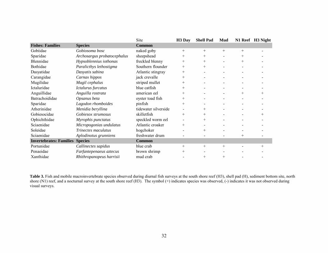
Table 3. Fish and mobile macroinvertebrate species observed during diurnal fish surveys at the south shore reef (H3), shell pad (H), sediment bottom site, north shore (N1) reef, and a nocturnal survey at the south shore reef (H3). The symbol (+) indicates species was observed, (-) indicates it was not observed during visual surveys.
Site H3 Day Shell Pad Mud N1 Reef H3 NightFishes: Families Species CommonGobiidae Gobiosoma bosc naked goby + + + + -Sparidae Archosargus probatocephalus sheepshead + + - + -Blennidae Hypsoblennius iothonas freckled blenny + + - + -Bothidae Paralicthys lethostigma Southern flounder + + - - -Dasyatidae Dasyatis sabina Atlantic stingray + - - - -Carangidae Carnax hippos jack crevalle + - - - -Mugilidae Mugil cephalus striped mullet + - - - -Ictaluridae Ictalurus furcatus blue catfish + - - - -Anguillidae Anguilla rostrata american eel + - - + +Batrachoididae Opsanus beta oyster toad fish + - - - -Sparidae Lagodon rhomboides pinfish + - - - -Atherinidae Menidia beryllina tidewater silverside - + - - -Gobiesocidae Gobiesox strumosus skilletfish + + - - +Ophichthidae Myrophis punctatus speckled worm eel - + - - -Sciaenidae Micropogonias undulatus Atlantic croaker + - - - -Soleidae Trinectes maculatus hogchoker - + - - -Sciaenidae Aplodinotus grunniens freshwater drum - - - + -Invertebrates: Families Species CommonPortunidae Callinectes sapidus blue crab + + + - +Penaeidae Farfantepenaeus aztecus brown shrimp + - - - -Xanthidae Rhithropanopeus harrisii mud crab - + + - -

33
0
100
200
300
400
500
600To
tal n
umbe
r sig
hted
REEF SHELL PAD MUD
(13 species) (8 species) (1 species)
A. grunniens
T. maculatus
M. undulatus
M. punctatus
G. strumosus
M. beryllina
L. rhomboides
O. beta
A. rostrata
I. furcatus
M. cephalus
C. hippos
D. sabina
P. lethostigma
H. iothonas
A. probatocephalus
G. bosc
Figure 6. Comparison of species and abundances of fishes observed at the Lake Pontchartrain artificial reef, shell pad, and sediment bottom sites in 2005.
0
10
20
30
40
50
60
70
Tota
l num
ber s
ight
ed
REEF SHELL PAD MUD
(2 species) (2 species) (2 species)
R. harrisii
F. aztecus
C. sapidus
Figure 7. Comparison of species and abundances of mobile macroinvertebrates observed at the Lake Pontchartrain artificial reef, shell pad, and sediment bottom sites in 2005.

34
Callinectes sapidus was the most commonly observed macroinvertebrate at the artificial
reef during visual surveys, totaling 86 out of 127 (68%) observations (Figure 7, Appendix D).
Interestingly, 32 out of 39 C. sapidus on the shell pad were associated with additional artificial
structures, including bricks, tires, pails, and other debris. On the reef site, cavities were observed
in the shell around the base reef balls. These cavities were occupied and presumably dug by
juvenile and adult C. sapidus. On 24 June 2005, four pairs of C. sapidus were observed in
precopulatory or postcopulatory embraces, where a female was in an upright position cradled by
a male (Bushmann 1991) inside hollows in the reef balls. In July, molted C. sapidus
exoskeletons were present in and around reef balls on the south shore reefs.
Gillnet sampling on 22 July 2005 yielded two Bagre marinus (gafftopsail catfish). One
M. undulatus was caught on 18 August 2005. Weather and time constraints due to Hurricane
Katrina restricted further experimentation of gillnet sampling methods on the reefs, including
deployment over the reefs with diver assistance.
Fishing Activity
Vessel Observations
Fifteen boats were observed at the Lake Pontchartrain artificial reefs during nine days in
2004 (Appendix F). Anglers occupied 14 of the 15 boats, and SCUBA divers visiting the south
shore reefs occupied the one other. During 2005, 96 boats containing 70 or more anglers were
recorded during 18 observation days (Appendix F). Anglers were observed catching fish on
October 28 2004, 27 April 2005, and 14 May 2005 including Cynoscion nebulosus (spotted sea
trout), M. undulatus, and P. lethostigma (Appendix F).

35
Boats were present at reefs on six of nine days (67%) in 2004, and on 15 of 18 (83%)
days in 2005. At the south shore reefs, the number of boats per reef ranged from zero to five
(mean of 0.6 ± 1.1) in 2004, and zero to eight (mean of 1.1 ± 1.3) in 2005. Commercial fishing
for blue crabs was also noted at and around the south shore reefs on one day in 2004 and 14 days
in 2005 (Appendix F).
Fishing Rodeo Surveys
Six fishing activity surveys were collected at the 2004 LPBF Fishing Rodeo. Poor
weather conditions limited angler turnout at this event. Of the anglers interviewed, all were
aware of the artificial reefs but none had fished them during the Rodeo. Reasons for this
included rough conditions on the lake, having fished the reefs earlier that week/month with no
success, and lack of transportation to the reefs. Three surveys were collected at the 2005 LPBF
Fishing Rodeo. Windy conditions deterred anglers from fishing offshore at the reefs, but all
fishermen were knowledgeable of the reefs and had fished them in the past.
Internet-based Creel Surveys
The Lake Pontchartrain Artificial Reef Recreational Fishing and Diving Survey
(Appendix E) posted on the LPBF website in October 2004 generated two responses in 2004
(Appendix G). Visitors to the LPBF and Louisiana Fishing and Hunting websites submitted 19
surveys in 2005. Of the 21 respondents, 17 reported that the reefs have enhanced recreational
fishing in Lake Pontchartrain and five said that the reefs have enhanced diving opportunities.
Four of those five reported enhanced fishing and diving in the lake. Fourteen respondents fished
more in the past year than the previous as result of reef presence, and four people had dived more

36
(Appendix G). Surveys indicated that sixteen respondents (76%) visited the south shore
(Jefferson Parish) reefs, three visited the north shore (St. Tammany Parish) reef, and two visited
the Orleans Parish artificial reef. Total time spent at each reef location was 43, 3.5, and 0.6
hours for the Jefferson (H1, H3, and H4), St. Tammany (N1), and Orleans reefs (L1),
respectively. Seventeen of the respondents fished with hook and line, three spearfished, and the
one diver did not fish. Individual respondents reported seeing between zero and 65 other anglers
at the south shore reefs (mean of 17, 15 adults and two children) while fishing.
Most anglers’ primary target species was speckled trout (17 of 21 respondents).
Eight of those anglers caught speckled trout, landing 10 - 35 individuals (mean of 21 ± 9) per
boat. All speckled trout were caught at the south shore reefs. Respondents caught other species
at the south shore reefs including, flounder (three respondents), sheepshead (three respondents),
white trout (one respondent), and catfish (one respondent) (Appendix G). One respondent fished
the north shore reef and caught hardhead and gafftopsail catfishes at the north shore reef. The
two respondents that fished the Orleans reef were not successful. Problems that anglers
encountered at the reefs included fishing tackle losses (eight respondents), trouble locating reefs
(five respondents), and crowded conditions (four respondents). Respondents comments included
requests for a diagram depicting reef and buoy orientation, reports of missing buoys and vessel
crowding, and concern for safety at the reef sites when divers are present (Appendix G).

37
DISCUSSION
Structural integrity analyses indicate that reef balls are a stable artificial reef material in
Lake Pontchartrain when placed on shell pads. The reefs remained in their original deployment
positions despite passage of strong storms over southeastern Louisiana and Lake Pontchartrain in
2004. One challenge for future evaluation of reef stability is that the fixative used to mount
identification plates to the balls has deteriorated and many plates have fallen off. Application of
a durable marine fixative is recommended for future reef construction.
The artificial reefs might act as vertical refuge for benthic invertebrates and fishes during
episodes of low dissolved oxygen in bottom waters in Lake Pontchartrain, although hypoxia was
not detected during this study. Impacts of hypoxia on fisheries in the Gulf of Mexico include
fish avoidance or migration away from hypoxic areas for motile species, and stress or mortality
for more sessile fishes and macroinvertebrates (Rabalais et al. 2001). Whether hypoxia caused
by salinity stratification from the INHC persists as far west as the Jefferson Parish artificial reefs
is not known but could be determined by further study of epifaunal macroinvertebrates on reefs
and other hard substrates. Sessile invertebrates can be used as indicators of environmental stress
through documentation of their survival, growth, and succession over time (Porrier and Rogers
1975). Salinity stratification was detected near the south shore reefs on 25 October 2004, during
lake-wide benthos surveys conducted by UNO Estuarine Research Laboratory researchers.
Surface and bottom dissolved oxygen levels differed by greater than 4 mg/L, and bottom
dissolved oxygen was below 2 mg/L, suggesting a hypoxic event just west of the artificial reefs
(unpublished data). Other evidence of hypoxia in the southwestern region of the lake came from

38
a report by a commercial blue crab fisherman on 10 August 2005. The fisherman reported dead
crabs in his traps from the Seabrook Bridge to the Bonnet Carre Spillway due to a “wedge of bad
water.” He also reported lower landings than average for that time of year (Ronnie, pers.
comm.). Collection of water quality data throughout Lake Pontchartrain during the summer and
fall would clarify whether the artificial reefs provide vertical relief from hypoxia, mitigating
environmental stress and providing refuge for benthic invertebrates and fishes.
Initial macroinvertebrate colonization of the south shore artificial reefs was gradual.
Percent cover of epifauna was negligible throughout 2004 but increased considerably in 2005.
Interestingly, similarity of taxa on the south shore reefs and Causeway Bridge and oil/gas
platform pilings was over 90% in May 2005 (Bray-Curtis similarity index, Clarke and Warwick
1994), although the ages of these structures vary from less than two years (reefs) to fifty years
(Causeway Bridge pilings). Stress, a measure of adequacy of the Bray-Curtis similarity analysis,
was less than 0.01, which indicated that the multidimensional scaling plot of similarity provided
a strong representation of the relationships (Clarke and Warwick 1994). Epifaunal samples that
exhibited the greatest similarity were those with spatial and temporal likeness, such as those
taken in May 2005 from the south shore reef, Causeway pilings, and oil/gas platform pilings.
Epifauna on the south shore reefs in August 2005 was most dissimilar (<50%) from epifauna
found on south or north shore reefs or reference sites throughout the survey period. Visual
observations of macroinvertebrates on the reefs indicated little to no live hydroid or sponge and
epifaunal scrape samples primarily contained decaying organic matter. A plausible explanation
for the lack of live sessile colonial macroinvertebrates in August 2005 is that an undetected
hypoxic event affected the south shore reefs. Other reasons for the mortality could be

39
abnormally high water temperatures or other adverse water quality parameter, none of which
were detected in July or August 2005.
In visual comparisons, barnacles were found to be larger and more abundant on the
Causeway and oil/gas platform pilings than on reef balls, which might be due to predation of the
barnacles by fish and mobile macroinvertebrates. Barnacles and small clams, Congeria
leucophaeta, were present only in crevices on irregular reef surfaces. The rugosity may have
provided refuge from grazing pressure (Hixon and Brostoff 1985). Blue crabs Callinectes
sapidus feed on a variety of crustaceans, molluscs, fish, and detritus and have been characterized
as opportunistic benthic omnivores (Darnell 1959, Perry and McIlwain 1986). When available
they will feed on barnacles (Ryer 1987). Certain fishes also regularly consume barnacles such as
adult sheepshead Archosargus probatocephalus (Jennings 1985). This omnivorous fish is
associated with structural habitat (Jennings 1985) and was regularly sighted at the reefs.
Predation affects sessile assemblages on artificial reefs (Bohnsack et al. 1991), thus identification
of food web interactions is important for understanding colonization patterns (Bohnsack and
Sutherland 1985). One method for assessing predation would be to use predator exclusion
devices such as mesh cages (Steele 1996, Connell 1997). Invertebrate assemblages on reef balls
excluded from predators may have higher species diversity and surface coverage than
assemblages on balls exposed to predators. Because water current modifications produced by the
reef may also differentially affect epifaunal growth (Baynes and Szmant 1989, Lindquist and
Pietrafesa 1989, Sheng 2000), treatments should be assigned to all orientations of surfaces of the
reef. Fish stomach contents can also be analyzed to determine if prey items are associated with
natural or artificial substrates. Additional research is necessary to test this hypothesis and
determine if predation rates differ between reef and oil and gas platform or Causeway Bridge

40
pilings. Changes in macroinvertebrate community composition are likely to occur as the reef
matures. Information on factors affecting settlement of epifauna under estuarine conditions is
valuable for future reef efforts in Lake Pontchartrain and in other low-salinity estuaries.
Visual surveys indicated that artificial reefs are productive fish and invertebrate habitats
with higher diversity and abundance of fishes than the shell pad and natural sediment bottom
sites. Archosargus probatocephalus, Paralichthys lethostigma, and Ictalurus furcatus are valued
recreational species (O’Connell et al. 2005) and were recorded at the reef. The naked goby
Gobiosoma bosc was highly abundant at the reefs. Although G. bosc is known to be one of the
three most abundant species of fish along the Louisiana coast (Rakocinski et al. 1992, Baltz et al.
1993), its distribution is dependent on habitat attributes including reef structure (Weiderholm
1987). Gobies, including G. bosc, constitute a portion of the diet of several commercial and
recreational fishes including Cynoscion nebulosus, Micropogon undulatus, Pogonias cromis
(black drum), and Sciaenops ocellatus (red drum) (Darnell 1958, Dawson 1966, Carr and Adams
1973). When abundant, G. bosc larvae are an important food source for juvenile piscivorous
fishes in estuarine environments (Peterson and Ross 1991, Hendon et al. 2000). Gobiosoma bosc
presence indicates food availability at the reefs, which may enhance abundance of fishery
species.
Blue crabs Callinectes sapidus, were commonly sighted in the reefs. Louisiana leads the
US commercial landings (NMFS 2002) for this crustacean, of which a portion is harvested from
Lake Pontchartrain (Guillory and Perret 1998). Blue crabs occupy estuaries during various
phases as larvae, juveniles, and adults. As adults, males tend to stay within estuaries while
females migrate there for mating and spawning (Perry and McIlwain 1986). It appears that the
artificial reefs provide cover during certain vulnerable life stages. Juvenile C. sapidus were

41
frequently observed occupying cavities at the base of reef balls and adults pairs were seen in
mating (pre/postcopulatory) positions. Blue crab molts were also found inside cavities and
around the bases of reef balls. Mating occurs in estuaries, while the female is in a soft-shell state
(Guillory et al. 2001), and habitat structural complexity minimizes predation risk during this
vulnerable period (Hovel and Lipcius 2001). Structurally complex habitat provided by the reefs
likely enhances survival of C. sapidus in Lake Pontchartrain.
Some recreationally important species including Cynoscion nebulosus, C. arenarius
(sand seatrout), and Sciaenops ocellatus (O’Connell et al. 2005), were not observed during
surveys but were reported at the reefs by anglers (see following section on Fishing Activity).
These cryptic species are less likely to avoid detection due to heightened sensitivity to noises
produced by divers (i.e., bubbles exiting regulators) (Kimmel 1985). Although divers did not
observe these species at the reef or reference sites, anglers caught them with rod and reel. To
account for this discrepancy, visual surveys were supplemented by gillnet sampling at the reefs,
but only Bagre marinus and Micropogon undulatus were collected. A major limitation of the
gillnet method was that the net had to be placed adjacent to the reef rather than across it, in effect
sampling a different environment and assemblage. Developing gillnet sampling techniques
where the net is deployed directly over artificial reefs should improve efficacy of net use in
structurally complex habitats. Displacement of personnel and damage to research equipment by
Hurricane Katrina limited gillnet survey effort and precluded experimentation of over-reef net
deployment techniques.
An additional purpose of the visual surveys was to determine whether volunteers could
be used to systematically monitor Lake Pontchartrain artificial reefs. Based on the success of the
visual surveys, it is feasible to utilize volunteers to conduct RDT-style fish surveys and to

42
monitor reef stability (Whitmore and Poirrier 2006). Water clarity is usually sufficient for reef
surveys after three to five days of low wind conditions (less than 10 knots), especially in late
summer. Implementing a regular dive schedule should help to coordinate volunteers, as it was
difficult to assemble teams during brief windows of suitable visibility. In 2004, a list of about 50
divers interested in participating in Lake Pontchartrain artificial reef surveys was compiled.
Many of these volunteers were active divers with the Aquarium of the Americas in New Orleans,
LA and the Hammerhead Dive Club in Mandeville, LA. Several had assisted with deployment
and early monitoring dives at the reef sites (Lopez 2004). A protocol for surveying the reefs
using volunteers was developed based on methods used by the Reef Environmental Education
Foundation (REEF). Pending authorization from REEF, Lake Pontchartrain will be added to
REEF’s list of Project Areas, which would allow current and future fish survey data to be
submitted online and later accessed by the public. Public involvement in reef monitoring will
encourage support and knowledge of the reefs, supplement key datasets on reef performance, and
support a long-term monitoring program.
Observations of recreational activity indicated that fishing and diving have been taking
place at the Lake Pontchartrain artificial reefs, and that recreational activity increased from 2004
to 2005. Data on fishes at the reefs gathered through the internet-based creel surveys
supplemented visual surveys, and revealed angler experiences at the artificial reefs sites.
Internet-based creel surveys can be used to inexpensively and consistently monitor reef
performance, recreational user preferences, and experiences when on-site evaluation is not
feasible. Creel surveys provided insight to problems that users experienced, such as confusion
about reef size and orientation relative to the buoy, displaced buoys, and errors in and difficulty
interpreting the format of published coordinates. We observed anglers mooring to reef buoys,

43
which probably caused the buoys to be dragged off of the reef sites and later contributed to
confusion about reef to buoy orientation. Signage at boat launches and greater public outreach of
proper mooring techniques could address this problem. Overall, recreational users are satisfied
with the reefs and feel that they have enhanced fishing and diving opportunities in Lake
Pontchartrain. Many suggested that the program be expanded to accommodate growing interest
and offer reef-fishing opportunities in other parts of the lake.
Data collected during this two-year evaluation of the Lake Pontchartrain artificial reefs
demonstrate that the reefs have performed according to expectations. Macroinvertebrates have
begun colonizing available hard substrate, recreationally important fish species have been
observed by divers and caught by anglers, and commercially important blue crabs have also been
recorded at the reefs. Reef development has also expanded recreational fishing and diving
opportunities in the lake.

44
CONCLUSIONS
Lake Pontchartrain is the largest oligohaline estuary in the southeastern U.S. (Moore
1992) and essential habitat for many of Louisiana’s coastal fisheries (Penland et al. 2002).
Generally, coastal estuaries are the most productive and commercially important fisheries
habitats worldwide (Boesch et al. 1994, Chesney et al. 2000, Demers et al. 2000). Despite their
importance, estuaries are also among the most endangered and altered aquatic habitats. Lake
Pontchartrain restoration and revitalization efforts have improved environmental quality in the
lake over the last few decades (Abadie and Poirrier 2001, Bourgeois-Calvin et al. 2004, LPBF
2005). The Lake Pontchartrain Artificial Reef Program has fostered awareness of these
improved conditions and lake resources. Study of the reefs has generated background on
artificial reef performance in low-salinity estuaries and can be used to assess the efficacy of
future estuarine artificial reef development. Although estuaries are not commonly selected for
artificial reef development, they are likely to become a focus of such efforts. Reef development
tends to be highest near urban centers (Booth and Cox 2003) in coastal areas, and sites that are
within easy access of boat launches or ports and have reasonable water clarity for diving are
most likely to be considered. As coastal populations grow, citizens push for expanded local
recreational opportunities. Development around estuaries such as Lake Pontchartrain continues
to intensify and thus estuarine artificial reef development is expected to rise as well. Additional
work is necessary to compare and consolidate information on brackish water habitat
enhancements and to determine strategies for designing reefs that maximize ecological, social,
and economic benefits.

45
LITERATURE CITED
Abadie, W. and M. Poirrier. 2001. Increased density of large Rania clams in Lake Pontchartrain
after the cessation of shell dredging. Journal of Shellfish Research 19:481-485.
Anderson, M.J. 1996. A chemical cue induces settlement of Sydney rock oysters, Saccostrea
commercialis, in the laboratory and in the field. Biological Bulletin of the Marine
Laboratory, Woods Hole 190:350-358.
Ambrose, R.F. and S.L. Swarbrick. 1989. Comparison of fish assemblages on artificial and
natural reefs off the coast of southern California. Bulletin of Marine Science 44:718-733.
Baltz, D.M., C. Rakocinski, and J.W. Fleeger. 1993. Microhabitat use by marsh-edge fishes in a
Louisiana estuary. Environmental Biology of Fishes 36:109-126.
Baynes, T.W. and A.M. Szmant. 1989. Effect of current on the sessile benthic community
structure of an artificial reef. Bulletin of Marine Science 44:545-566.
Bell, M., M. Buchanan, J. Culbertson, J. Dodrill, R. Kasprzak, R. Lukens, and W. Tatum. 1997.
Guidelines for marine artificial reef materials. Gulf States Marine Fisheries Comm.123 p.
Boesch, D.F., M.N. Josselyn, A.J. Mehta, J.T. Morris, W.K. Nuttle, C.A. Simmestad, D.P. Swift.
1994. Scientific assessment of coastal wetland loss, restoration, and management in
Louisiana. Journal of Coastal Research 20:1-103.
Bohnsack, J.A. 1989. Are high densities of fishes at artificial reefs the result of habitat limitation
or behavioral preference? Bulletin of Marine Science 44:631-645.
Bohnsack, J.A., A.M. Ecklund, and A.M. Szmant. 1997. Artificial reef research: Is there more
than the attraction-production issue? Fisheries 22:14-16.

46
Bohnsack, J.A. and D.L. Sutherland. 1985. Artificial reef research: a review with
recommendations for future priorities. Bulletin of Marine Science 37:11-39.
Bohnsack, J.A., D.L. Johnson, and R.F. Ambrose. 1991. Ecology of artificial reef habitats and
fishes. Pp 61-107. In: W. Seaman, Jr. and L.M. Sprague (eds.). Artificial Habitats for
Marine and Freshwater Fishes. Academic Press, New York.
Booth, J.D. and O. Cox. 2003. Marine fisheries enhancement in New Zealand: our perspective.
New Zealand Journal of Marine and Freshwater Research 37:673-690.
Bortone, S.A., R.W. Hastings, J.L. Oglesby. 1986. Quantification of reef fish assemblages: a
comparison of several in situ methods. Northeast Gulf Science 8:1-22.
Bortone, S.A., T. Martin, and C.M. Brundrick. 1994. Factors affecting fish assemblage
development on a modular artificial reef in a northern Gulf of Mexico Estuary. Bulletin of
Marine Science 55:319-332.
Bortone, S.A., M.A. Samoilys, and P. Francour. 2000. Fish and macroinvertebrate evaluation
methods. In: Seaman, W. (ed.) Artificial Reef Evaluation with Application to Natural
Marine Habitats. CRC Press, Boca Raton, pp. 1-20.
Brock, R.E. 1982. A critique of the visual census method for assessing coral reef fish
populations. Bulletin of Marine Science 32:269-276.
Bourgeois-Calvin, A., J. Mastrototaro, S.L. Briuglio. 2004. A non-profit approach to addressing
the effects of urbanization in the Lake Pontchartrain Basin, Louisiana. Urban Ecosystems
7:157-167.
Brusca, R. and G. Brusca. 1990. Invertebrates. Sinauer Associates Inc., Sunderland,
Massachusetts, pp. 198-200.

47
Buckeridge, J. Interim Report on the Artificial Reef. November 2002. Earth and Oceanic Science
Research Centre, Auckland University of Technology. Accessed 13 January 2005 from
http://www.artificialreefs.org/ScientificReports/NewZealand/htm
Bushmann, P.J. 1991. Concurrent signals and behavioral plasticity in blue crab (Callinectes
sapidus Rathbun) courtship. Biological Bulletin 197:63-71.
Carr, W.S. and C.A. Adams. 1973. Food habits of juvenile marine fishes occupying seagrass
beds in the estuarine zone near Crystal River, Florida. Transactions of the American
Fisheries Society 102:511-540.
Chesney, E.J., D.M. Baltz, and R.G. Thomas. 2000. Louisiana estuarine and coastal fisheries and
habitats: perspectives from a fish’s eye view. Ecological Applications 10:350-366.
Christian, R. F. Steimle, and R. Stone. 1998. Evolution of marine artificial reef development – a
philosophical review of management strategies. Gulf of Mexico Science 1:32-36.
Clarke, K.R. and R.M. Warwick. 1994. Change in marine communities: an approach to statistical
analysis and interpretation. Plymouth Marine Laboratories, Plymouth, 144 p.
Connell, S.D. 1997. Exclusion of predatory fish on a coral reef: the anticipation, pre-emption and
evaluation of some caging artifacts. Journal of Experimental Marine Biology and
Ecology 213:181-198.
Cowan, J.H. and W.F. Patterson. 2005. Attraction versus production of red snapper Lutjanus
campechanus on Alabama artificial reefs: conceptual models and evidence. Proceedings
of the 8th International Conference on Artificial Reefs and Artificial Habitats, Biloxi, MS,
10-14 April 2005 (in press).
Darnell, R.M. 1958. Food habits of fishes and invertebrates of Lake Pontchartrain. Publication of
the Institute of Marne Science, University of Texas 5:353:416.

48
Dawson, C.E. 1966. Studies on the gobies (Pisces: Gobiidae) of Mississippi Sound and adjacent
waters. I. Gobiosoma. American Midland Naturalist 76:79-409.
Demers, E., S.B. Brandt, K.L. Barry, and J.M. Jech. 2000. Spatially explicit models of growth
rate potential: linking estuarine fish production to the biological and physical
environment, pp. 405-425. In: J.E. Hobbie, (ed.). Estuarine Science: A Synthetic
Approach to Research and Practice. Island Press.
Eklund, A.M. 1997. The importance of post-settlement predation and reef resources limitation on
the structure of reef fish assemblages. Proceedings of the 8th International Coral Reef
Symposium 2: 1130-1142.
EPA (Environmental Protection Agency). Reef Ball – Punta Gorda Waterfront Juvenile Fisheries
Habitat Project. Accessed 13 January 2005 from
http://www.artificialreefs.org/Articles/PuntaGorda.htm
Guillory, V., W.E. Perret. 1998. Management, history, status, and trends in the Louisiana blue
crab fishery. Journal of Shellfish Research 17:413-424.
Guillory, V., H.M. Perry, and S.J. VanderKooy. 2001. The blue crab fishery of the Gulf of
Mexico, United States: A regional management plan. Ocean Springs, Mississippi: Gulf
States Marine Fisheries Commission.
Hendon, J.R., M.S. Peterson, and B.H. Comyns. 2000. Spatio-temporal distribution of larval
Gobiosoma bosc in waters adjacent to natural and altered marsh-edge habitats of
Mississippi coastal waters. Bulletin of Marine Science 66:143-156.
Hixon, M.A. and Brostoff. 1985. Substrate characteristics and Caribbean fish assemblages:
experiments with artificial reefs. Bulletin of Marine Science 44:666-680.

49
Hovel, K.A. and R.N. Lipcius. 2001. Habitat fragmentation in a seagrass landscape: patch size
and complexity control blue crab survival. Ecology 82:1814-1829.
Jennings, C.A. 1985. Species profiles: life histories and environmental requirements of coastal
fishes and invertebrates (Gulf of Mexico) – sheepshead. U.S. Fish and Wildlife Service
Biological Report 82(11.29). U.S. Army Corps of Engineers, TR EL-82-4, 10 p.
Junot, J., M. Poirrier, and T. Soniat. 1983. Effects of saltwater intrusion from the Inner Harbor
Navigation Canal on the benthos of Lake Pontchartrain, Louisiana. Gulf Research
Reports 7:247-254.
Kasprzak, R.A. 1998. Use of oil and gas platforms as habitat in Louisiana’s Artificial Reef
Program. Gulf of Mexico Science 1:37-45.
Kimmel, JJ. 1985. A new species-time method for visual assessment of fishes and its comparison
with established methods. Environmental Biology of Fishes 12:23-32.
Lindquist, D.G. and L.J. Pietrafesa. 1989. Current vortices and fish aggregations: The current
field and associated fishes around a tugboat wreck in Onslow Bay, North Carolina.
Bulletin of Marine Science 44:533-544.
Lopez, J. 2004. The Lake Pontchartrain Artificial Reef Program Deployment from 2000 to 2004.
Final Report submitted to the Lake Pontchartrain Basin Foundation and Louisiana
Department of Wildlife and Fisheries, 70 p.
Louisiana Department of Wildlife and Fisheries. Louisiana Artificial Reef Program. Accessed 20
February 2005 from http://www.wlf.state.la.us/apps/netgear/index.asp?cn=lawlf
LSU (Louisiana State University). Hurricane Katrina and Rita Clearinghouse Cooperative.
Accessed 14 February 2006. http://katrina.lsu.edu.

50
LPBF (Lake Pontchartrain Basin Foundation). Accessed 15 November 2005 from
http://saveourlake.org/index.htm
LPARWG (Lake Pontchartrain Artificial Reef Working Group). Lake Pontchartrain Artificial
Reef Program brochure. February 2004. Lake Pontchartrain Basin Foundation and
members of the Lake Pontchartrain Artificial Reef Working Group, 2 p.
LUMCON (Louisiana Universities Marine Consortium). LUMCON Weather Archive Data for
Lake Pontchartrain. Accessed 24 January 2004 from
http://weather.lumcon.edu/archivedata/select.asp.
LUMCON (Louisiana Universities Marine Consortium). LUMCON Weather Data Archive.
Accessed 20 January 2005 from http://weather.lumcon.edu/archivedata/select.asp.
Martin, T.R. and S.A. Bortone. 1997. Development of an epifaunal assemblage on an estuarine
artificial reef. Gulf of Mexico Science 2:55-70.
Matthews, K.R. 1985. Species similarity and movement of fishes on natural and artificial reefs in
Monterey Bay, California. Bulletin of Marine Science 37:252-270.
McGlennon, D. and K.L. Branden. 1994. Comparison of catch and recreational anglers fishing
on artificial reefs and natural seabed in Gulf St. Vincent, South Australia. Bulletin of
Marine Science 55:510-523.
Miller, M.W. and A. Falace. 2000. Evaluation methods for trophic resource factors – nutrients,
primary production, and associated assemblages. In: W. Seaman, Jr. (ed.). Artificial Reef
Evaluation with Application to Natural Marine Habitats. CRC Press, Boca Raton.
Moore, R.H. 1992. Low-salinity backbays and lagoons. In: Hackney, C.T., S.M. Adams, and
W.H. Martin (eds.). Biodiversity of the Southeastern United States: Aquatic
Communities. New York: Wiley, pp. 541-614.

51
NMFS. 2002. Fisheries of the Unites States, 2001. US Department of Commerce, National
Oceanic and Atmospheric Administration, National Marine Fisheries Service.
NOAA (National Oceanic Atmospheric Administration), National Weather Service, National
Hurricane Center. Tropical Weather Summary. Accessed 8 November 2004 from
http://www.nhc.noaa.gov/archive/2004/tws/MIATWSAT_sep.shtml
NOAA (National Oceanic Atmospheric Administration), National Hurricane Center, Tropical
Prediction Center. 2005 Atlantic Hurricane Season. Accessed 23 January 2005 from
http://www.nhc.noaa.gov/2005atlan.shtml
NOAA (National Oceanic Atmospheric Administration). 2006. Post Storm Data Acquisition
Aerial Wind Analysis and Damage Assessment, Hurricane Katrina. Technical Report,
October 31, 2005. Accessed April 3, 2006 from
http://www.nws.noaa.gov/os/data/pdfs/KatrinaPSDA.pdf, 11 p.
O’Connell, M.T., C.D. Franze, E.A. Spalding, and M.A. Poirrier. 2005. Biological resources of
the Louisiana coast: Part 2, coastal animals and habitat associations. Journal of Coastal
Research SI44:146-161.
Pattengill-Semens, C. and B. Semmens. 1998. An analysis of fish survey data generated by
nonexpert volunteers in the Flower Garden Banks National Marine Sanctuary. Gulf of
Mexico Science 2:196-207.
Penland, S., A. Beall, and D. Maygarden. 2002. Environmental status and trends of the Lake
Pontchartrain Basin. In: S. Penland, A. Beall, and J. Kinder (eds.) Environmental Atlas of
Lake Pontchartrain. USGS Open File Report 02-206.
52
Perry, H.M. and T.D. McIlwain. 1986. Species profiles: life histories and environmental
requirements of coastal fishes and invertebrates (Gulf of Mexico) blue crab. U.S. Fish
and Wildlife Service Biological Report 82(11.55). U.S. Army Corps of Engineers, 21 p.
Perry, H. K. Larson, J. Warren, and C. Trigg. 2001. Seasonal colonization of low profile artificial
reefs in Mississippi coastal waters: Invertebrates. Proceedings of the 52nd Annual Gulf
and Caribbean Fisheries Institute 52:498-511.
Peterson, M.S. and S.T. Ross. 1991. Dynamics of littoral fishes and decapods along a coastal
river-estuarine gradient. Estuarine, Coastal, and Shelf Science 33:467-483.
Pickering, H.D. and D. Whitmarsh. 1997. Artificial reefs and fisheries exploitation: a review of
the ‘attraction versus production’ debate, the influence of design and its significance for
policy. Fisheries Research 31:39-59.
Pickering, H., D. Whitmarsh, and A.C. Jensen. 1998. Artificial reefs as a tool to aid rehabilitation
of coastal ecosystems: investigating the potential. Marine Pollution Bulletin 37:505-514.
Poirrier, M.A. 1978. Studies of salinity stratification in southern Lake Pontchartrain near the
Inner Harbor Navigation Canal. Proceedings of the Louisiana Academy of Sciences
41:26-35.
Poirrier, M.A. 1984. An Identification Guide to the Macroscopic Invertebrates of the Lake
Pontchartrain Estuary, Louisiana. Louisiana Department of Environmental Quality,
Water Pollution Control Division, 47 p.
Poirrier, M.A. 2001. Lake Pontchartrain Artificial Reef Evaluation Program Quality Assurance
Project Plan. Estuarine Research Laboratory, Department of Biological Sciences,
University of New Orleans, Louisiana, 24 p.
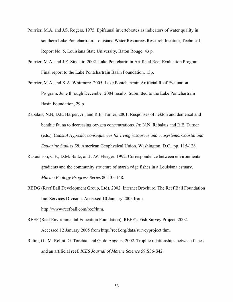
53
Poirrier, M.A. and J.S. Rogers. 1975. Epifaunal invertebrates as indicators of water quality in
southern Lake Pontchartrain. Louisiana Water Resources Research Institute, Technical
Report No. 5. Louisiana State University, Baton Rouge. 43 p.
Poirrier, M.A. and J.E. Sinclair. 2002. Lake Pontchartrain Artificial Reef Evaluation Program.
Final report to the Lake Pontchartrain Basin Foundation, 13p.
Poirrier, M.A. and K.A. Whitmore. 2005. Lake Pontchartrain Artificial Reef Evaluation
Program: June through December 2004 results. Submitted to the Lake Pontchartrain
Basin Foundation, 29 p.
Rabalais, N.N, D.E. Harper, Jr., and R.E. Turner. 2001. Responses of nekton and demersal and
benthic fauna to decreasing oxygen concentrations. In: N.N. Rabalais and R.E. Turner
(eds.). Coastal Hypoxia: consequences for living resources and ecosystems. Coastal and
Estuarine Studies 58. American Geophysical Union, Washington, D.C., pp. 115-128.
Rakocinski, C.F., D.M. Baltz, and J.W. Fleeger. 1992. Correspondence between environmental
gradients and the community structure of marsh edge fishes in a Louisiana estuary.
Marine Ecology Progress Series 80:135-148.
RBDG (Reef Ball Development Group, Ltd). 2002. Internet Brochure. The Reef Ball Foundation
Inc. Services Division. Accessed 10 January 2005 from
http://www/reefball.com/reef/htm.
REEF (Reef Environmental Education Foundation). REEF’s Fish Survey Project. 2002.
Accessed 12 January 2005 from http://reef.org/data/surveyproject.thm.
Relini, G., M. Relini, G. Torchia, and G. de Angelis. 2002. Trophic relationships between fishes
and an artificial reef. ICES Journal of Marine Science 59:S36-S42.

54
Roehl, E. and L. Harris. 1996. Stability analysis of Reef Ball artificial reef units. Florida Institute
of Technology Wave Tank and Stability Analysis. Report prepared for Reef Ball
Development Group Ltd. Accessed 16 December 2004 from
http://www.reefball.org/stab.htm.
Ryer, C.H. 1987. Temporal patterns of feeding by blue crabs (Callinectes sapidus) in a tidal-
marsh creek and adjacent seagrass meadow in the lower Chesapeake Bay. Estuaries
10:136-140.
Sale, P.F. and W.A. Douglas. 1981. Precision and accuracy of visual census technique for fish
assemblages on coral patch reefs. Environmental Biology of Fishes 6:333-339.
Schmitt, E. and K. Sullivan. 1996. Analysis of a volunteer method for collecting fish presence
and abundance data in the Florida Keys. Bulletin of Marine Science 59:404-416.
Seaman, W and A. Jensen. 2000. Purposes and practices of artificial reef evaluation. In: Seaman,
W. (ed) Artificial Reef Evaluation with Application to Marine Habitats. CRC Press, Boca
Raton, pp. 1-20.
Seaman, W., R.M. Buckley, and J.J. Polovina. 1989. Advances in knowledge and priorities for
research, technology, and management related to artificial aquatic habitats. Bulletin of
Marine Science 44:527-532.
Serviss, G. and S. Sauers. 2003. Sarasota Bay Juvenile Fisheries Habitat Assessment. Final
Report to the Sarasota Bay National Estuary Program, 212 p.
Sheng, Y.P. 2000. Physical characteristics and engineering at reef sites. In: W. Seaman, Jr. (ed.).
Artificial Reef Evaluation with Application to Natural Marine Habitats. CRC Press, Boca
Raton.

55
Sikora, W.B. and B. Kjerfive. 1985. Factors influencing the salinity regime of Lake
Pontchartrain, Louisiana, a shallow coastal lagoon: Analysis of a long-term data set.
Estuaries 8: 170-180.
Steele, M.A. 1996. Effects of predators on reef fishes: separating cage artifacts from effects of
predation. Journal of Experimental Biology and Ecology 198:249-267.
Steimle, F., K. Foster, R. Kropp, and B. Conlin. 2002. Benthic macrofauna productivity
enhancement by an artificial reef in Delaware Bay, USA. ICES Journal of Marine
Science 59:S100-S105.
Stephens, J. and D. Pondella. 2002. Larval productivity of a mature artificial reef: the
ichthyoplankton of King Harbor, California, 1974 – 1997. ICES Journal of Marine
Science 59:51-58.
Stone, J.H. (ed.) 1980. Environmental analysis of Lake Pontchartrain, Louisiana, its surrounding
wetlands, and selected land uses, Vol. 1 & 2. Coastal Ecology Laboratory Center for
Wetland Response. Publication #LSU6180-08, LSU, Baton Rouge.
Suprenant, B.A. 2001. Designing concrete for exposure to seawater. Concrete Construction.
Swenson, E.M. 1980. General hydrography of Lake Pontchartrain, Louisiana. In: J.H. Stone.
(ed.) Environmental analysis of Lake Pontchartrain, Louisiana, its surrounding wetlands,
and selected land uses, Vol. 1. Prepared for U.S. Army Engineer District, New Orleans,
pp. 57-156.
Turpin, R.K. and S.A. Bortone. 2002. Pre- and post-hurricane assessment of artificial reefs:
evidence for potential use as refugia in a fishery management strategy. ICES Journal of
Marine Science 59:74-82.

56
USGS (United States Geological Survey). USGS Real-Time Water Data for station USGS
073802331 (COE) Lake Pontchartrain at West End, Louisiana. U.S. Army Corps of
Engineers, New Orleans District. Accessed 10 January 2005 from
http://nwis.waterdata.usgs.gov/la/nwis/dv?format=html&period=130&site_no=073802
Walker, B.K., B. Henderson, and R.E. Spieler. 2002. Fish assemblages associated with artificial
reefs of concrete aggregates or stone quarry offshore Miami Beach, Florida, USA.
Aquatic Living Resources 15:95-105.
Weiderholm, A.M. 1987. Habitat selection and interactions between three marine species
(Gobiidae). Oikos 48:28-32.
Whitmore, K.A. and M.A. Poirrier. 2006. Lake Pontchartrain Artificial Reef Evaluation: 2004 &
2005 Results. Final report submitted to the Lake Pontchartrain Basin Foundation, 62 p.
Wilding, T.A. and M.D.J. Sayer. 2002. Evaluating artificial reef performance: approaches to pre-
and post-deployment. ICES Journal of Marine Science 59:S222-S230.
Wilson, C.A., V.R. Van Sickle, D.L. Pope. 1987. Louisiana Artificial Reef Plan. Louisiana Sea
Grant College Program, Louisiana State University, Baton Rouge, Louisiana. Louisiana
Department of Wildlife and Fisheries Technical Bulletin No. 41, 143 p.
Zalmon, I.R., R. Novelli, M.P. Gomes, and V.V. Faria. 2002. Experimental results of an artificial
reef programme on the Brazilian coast of north Rio de Janeiro. ICES Journal of Marine
Science 59:83-87.
Personal Communications
Lane, M. Publisher, Louisiana Fishing and Hunting website (http://rodnreel.com). 16 Nov. 04.
Ronnie. Lake Pontchartrain commercial blue crab fisherman. 10 Aug. 2005.
Raulerson, G. Sr. Environmental Scientist, Sarasota Bay National Estuary Program. 12 Jan. 04.

57
Appendix A. Dive log of all trips made to the artificial reef and reference sites in 2004 & 2005.

58

59

60
Appendix B. Water quality measurements taken at the Lake Pontchartrain artificial reefs and reference sites in 2004 and 2005.

61

62
Appendix C. Divers, weather conditions, survey locations, and durations of 2005 visual surveys at the Lake Pontchartrain artificial reefs.

63
Appendix D. Fishes and mobile macroinvertebrates sighted during visual surveys at the Lake Pontchartrain artificial reef and reference sites in 2005.

64

65
Appendix E. Lake Pontchartrain Artificial Reef Recreational Fishing and Diving Survey.
LLaakkee PPoonnttcchhaarrttrraaiinn AArrttiiffiicciiaall RReeeeff RReeccrreeaattiioonn SSuurrvveeyy This survey is designed to collect information on the success of the artificial reefs in Lake Pontchartrain. Information on fisher and diver utilization of the reefs will be used to monitor the progress of the reefs and to develop recommendations for future reef efforts. Respondent contact information will remain confidential and responses will be pooled with those of others. If you have recently fished or dived at any of the reef sites, please complete the form below and submit it via email to: [email protected] or print and mail the form to: Lake Pontchartrain Artificial Reef Program, Estuarine Research Laboratory, Department of Biological Sciences, University of New Orleans, New Orleans, LA 70148.
Please complete and submit the form after each visit to the artificial reefs!
1. What was the date of your most recent trip to a Lake Pontchartrain artificial reef? MM/DD/YY ____ /____ /____
2. Which reef site(s) did you visit that day? (check all that apply)
South shore - Jefferson Parish sites (H1, H3, H4), west of the Causeway Bridge: North shore - St. Tammany Parish site (N1), south of Mandeville: South shore - Orleans Parish site (L1) northeast of the Seabrook Bridge launch:
3. What activities did you conduct there?
Hook and line fishing Spear fishing Charter fishing
Diving Other _______________
4. How many hours did you spend fishing or diving at the reef sites that day? Specifically, how many
hours did you actually spent with your gear in the water? Total hours:
5. How many other people were fishing or diving from your boat at the reef sites that day?
Number of Adults (18+ yrs): Number of Children:
6. How many people did you see fishing or diving from other boats at the reef sites that day? Number of Adults (18+ yrs): Number of Children:
7. If you were fishing, what types of gear did you use to fish at the reef site(s) that day? Hook and line Dip net, A-frame Cast net Trawl
Trap Spear Hand Other _________
Unknown None, did not fish
8. If you were fishing, what type of fish were you fishing for at the artificial reef(s) that day?
1st target species ________________________
2nd target species _________________________
No particular target species
9. Where else in the lake did you fish or dive from a boat that day? Standing oil & gas structure Causeway pilings Other structure (specify) __________________________________

66
None/ No other areas
10. What fish did you catch, or if diving, what fish did you see at the reef sites that day?
Species Number Range of Length/Weight Gear Bait Taken/Released
11. Since January 2004, how many days have you fished or dived at the artificial reefs in Lake
Pontchartrain? Total days:
Of those days, how many were spent at each of the following artificial reef locations?
Days at Jefferson Reefs: Days at St. Tammany Reef: Days at Orleans Reef:
12. Within the past 2 months, how many days have you fished or dived at the artificial reefs in Lake
Pontchartrain? Total days:
Of those days, how many were spent at each of the following artificial reef locations?
Days at Jefferson Reefs: Days at St. Tammany Reef: Days at Orleans Reef:
13. Within the past 2 months, how many days have you fished or dived anywhere in Lake
Pontchartrain proper (including reef visits)? Total days:
14. Do you feel that the artificial reefs have enhanced recreational fishing and/or diving opportunities
in Lake Pontchartrain? Yes – enhanced fishing Yes – enhanced diving
No Other _________________
15. Have you fished or dived more often this year than last year as result of the presence of the Lake
Pontchartrain artificial reefs? Yes – fished more Yes – dived more No Other ____________________

67
16. Did you experience any problems at the artificial reefs that day? What were they?
Trouble anchoring Lost anchor Lost fishing tackle Difficulty finding reef site due to format of listed coordinates No buoy at the reef site Other ________________________________
17. What is your state and county of residence?
State: ______________________ County: _________________________
18. If you are a frequent user of the artificial reefs and would like to participate in a more regular,
formal survey and have logged your reef use, or would like to start, please check this box, and provide your contact information below:
19. OPTIONAL:
Please provide your name, address, phone number, and email address if you would like to receive more information about the Lake Pontchartrain Artificial Reef Project:
_________________________________________ _________________________________________ _________________________________________
20. Any comments you have about the Lake Pontchartrain Artificial Reef Program:
If you have any questions about this survey or about the Lake Pontchartrain Artificial Reef Program, please email the Lake Pontchartrain Basin Foundation at [email protected], or contact the Estuarine Research Laboratory at the University of New Orleans, LA, 504-284-3490, [email protected]. Thank you for your participation!


69
Appendix F. Observations of recreational fishing and diving activity at the Lake Pontchartrain artificial reefs in 2004 and 2005.
06/02/05 Th 9:20 - 9:30 H3 2 4 Fishing Rods w/ line in water Unknown06/02/05 Th 9:20 - 9:30 H4 1 3 Fishing Rods w/ line in water Unknown06/02/05 Th 9:20 - 9:30 H1 1 2 Fishing Rods w/ line in water Unknown06/02/05 Th 9:20 - 9:30 near H3 1 1 Checking traps Crab pots Unknown Blue crabs Crab pots set near H3 site06/02/05 Th 9:40 - 9:50 H3 1 Unknown Fishing Rods w/ line in water Unknown06/02/05 Th 9:40 - 9:50 H4 1 Unknown Fishing Rods w/ line in water Unknown06/02/05 Th 9:40 - 9:50 H1 2 Unknown Fishing Rods w/ line in water Unknown06/03/05 Fr 9:15 - 9:25 H3 3 Unknown Fishing Rods w/ line in water Unknown06/03/05 Fr 9:15 - 9:25 H1 2 Unknown Fishing Rods w/ line in water Unknown06/03/05 Fr 9:15 - 9:25 H4 3 Unknown Fishing Rods w/ line in water Unknown06/03/05 Fr 10:10 - 10:15 H3 2 Unknown Fishing Rods w/ line in water Unknown Crab pots set near H3 & H406/03/05 Fr 10:10 - 10:15 H4 4 Unknown Fishing Rods w/ line in water Unknown06/03/05 Fr 10:10 - 10:15 H1 2 Unknown Fishing Rods w/ line in water Unknown06/03/05 Fr 12:20 - 12:25 H3 2 Unknown Fishing Rods w/ line in water Unknown06/03/05 Fr 12:20 - 12:25 H1 006/03/05 Fr 12:20 - 12:25 H4 3 Unknown Fishing Rods w/ line in water Unknown06/09/05 Th 9:10 - 9:15 H3 3 4 Fishing Rods w/ line in water No Caught 50 trout 6/8 at H4, 12 on 6/606/09/05 Th 9:10 - 9:15 H1 1 2 Fishing Rods w/ line in water Unknown06/09/05 Th 9:10 - 9:15 H4 1 1 Fishing Rods w/ line in water Unknown06/09/05 Th 12:12 -12:17 H3 0 006/09/05 Th 12:12 -12:17 H4 2 3 Fishing Rods w/ line in water Unknown06/09/05 Th 12:12 -12:17 H1 0 006/18/05 Sa 14:32 - 14:45 H3 2 7 Fishing Rods w/ line in water Unknown Crab pots set around H3 & H4 06/18/05 Sa 14:32 - 14:45 H1 2 2 Fishing Rods w/ line in water Unknown06/18/05 Sa 14:32 - 14:45 H4 2 4 Fishing Rods w/ line in water Unknown06/23/05 Th 09:28 - 09:35 H3 2 3 Fishing Rods w/ line in water Unknown Crab pots set around H306/23/05 Th 09:28 - 09:35 H1 1 2 Fishing Rods w/ line in water Unknown06/23/05 Th 09:28 - 09:35 H4 2 3 Fishing Rods w/ line in water Unknown06/23/05 Th 11:00 - 11:05 H3 2 3 Fishing Rods w/ line in water Unknown06/23/05 Th 11:00 - 11:05 H4 1 2 Fishing Rods w/ line in water Unknown06/23/05 Th 11:00 - 11:05 H1 0 006/24/05 Fr 09:45 - 09:54 H3 3 5 Fishing Rods w/ line in water Unknown Crab pots set b/w H1, H3, & H406/24/05 Fr 09:45 - 09:54 H1 0 006/24/05 Fr 09:45 - 09:54 H4 2 3 Fishing Rods w/ line in water Unknown06/30/05 Th 11:30 - 11:40 H1 0 0 Crab pots set b/w H1, H3, & H406/30/05 Th 11:30 - 11:40 H4 0 006/30/05 Th 11:30 - 11:40 H3 0 006/30/05 Th 14:45 - 14:50 H1 0 0 Crab pots set b/w H1, H3, & H406/30/05 Th 14:45 - 14:50 H4 0 006/30/05 Th 14:45 - 14:50 H3 0 0

70
07/22/05 Fr 8:40 - 9:40 H1 0 007/22/05 Fr 8:40 - 9:40 H3 1 2 Fishing Rods w/ line in water Unknown Crab pots set b/w H1,H3 & H407/22/05 Fr 8:40 - 9:40 H4 0 007/22/05 Fr 10:15 - 10:30 H1 2 2 Fishing Rods w/ line in water Unknown07/22/05 Fr 10:15 - 10:30 H3 2 1 Fishing Rods w/ line in water Unknown07/22/05 Fr 10:15 - 10:30 H4 2 3 Fishing Rods w/ line in water Unknown07/26/05 Tu 8:09 - 8:15 H1 1 2 Fishing Rods w/ line in water Unknown Crab pots set b/w H1, H3 & H407/26/05 Tu 8:09 - 8:15 H3 0 007/26/05 Tu 8:09 - 8:15 H4 1 4 Fishing Rods w/ line in water Unknown08/03/05 We 11:59 - 14:10 H1 0 008/03/05 We 11:59 - 14:10 H3 0 008/03/05 We 11:59 - 14:10 H4 0 008/04/05 Th 9:09 - 9:15 H1 0 0 Crab pots set b/w H1, H3 & H408/04/05 Th 9:09 - 9:15 H3 0 008/04/05 Th 9:09 - 9:15 H4 0 008/04/05 Th 10:32 - 10:40 H1 0 008/04/05 Th 10:32 - 10:40 H3 0 008/04/05 Th 10:32 - 10:40 H4 0 008/05/05 Fr 9:15 - 9:30 H1 1 2 Fishing Rods w/ line in water Unknown Crab pots set b/w H1, H3 & H408/05/05 Fr 9:15 - 9:30 H3 0 008/05/05 Fr 9:15 - 9:30 H4 0 008/05/05 Fr 9:50 - 10:10 H1 0 008/05/05 Fr 9:50 - 10:10 H3 0 008/05/05 Fr 9:50 - 10:10 H4 0 008/16/05 Mo 8:50 - 9:20 H1 0 008/16/05 Mo 8:50 - 9:20 H3 0 008/16/05 Mo 8:50 - 9:20 H4 2 4 Fishing Rods w/ line in water Unknown Crab pots set near H108/16/05 Mo 10:09 - 10:15 H1 0 008/16/05 Mo 10:09 - 10:15 H3 0 008/16/05 Mo 10:09 - 10:15 H4 0 008/18/05 We 19:10 - 19:30 H1 1 2 Fishing Rods w/ line in water Unknown Crab pots set near H108/18/05 We 19:10 - 19:30 H3 0 008/18/05 We 19:10 - 19:30 H4 0 008/18/05 We 19:45 - 20:50 H1 0 008/18/05 We 19:45 - 20:50 H3 0 008/18/05 We 19:45 - 20:50 H4 0 008/21/05 Su 10:15 - 10:45 N1 2 4 Fishing Rods w/ line in water No North shore reef

71
Appendix G. Responses collected from the Lake Pontchartrain Recreational Fishing and Diving Survey in 2004 and 2005.
2004Respondent 1. Date 2. Site 3. Activity 4. Hours 5. People in boat 6. People in other boats 7. Gear 8. Target species
# Adults Children Adults Children 1st 2nd1 9/12/2004 St. Tammany reef (N1) Hook & line 0.5 1 0 0 0 Hook & line Speckled trout Flounder
2 9/29/2004 Jefferson reefs (H1) Hook & line 2 3 0 15 0 Hook & line Trout Redfish
2005Respondent 1. Date 2. Site 3. Activity 4. Hours 5. People in boat 6. People in other boats 7. Gear 8. Target species
# Adults Children Adults Children 1st 2nd1 5/15/2005 Jefferson reefs (H1, H3, H4) Hook & line 3.5 2 0 30 0 Hook & line Speckled trout none
2 5/22/2005 Jefferson reefs (H1, H3, H4) Hook & line 5 1 1 35 5 Hook & line Speckled trout none3 5/21/2005 Jefferson reefs (H1, H3, H4) Hook & line 4 2 0 20 7 Hook & line Speckled trout Croaker
4 5/14/2005 Jefferson reefs (H1, H3, H4) Hook & line 1 1 0 1 0 Hook & line Trout none5 6/9/2005 Jefferson reefs (H1, H3, H4) Hook & line 4 3 0 15 0 Hook & line Speckled trout Redfish6 6/4/2005 Jefferson reefs (H1, H3, H4) Hook & line 4 2 0 30 0 Hook & line Trout none
7 6/24/2005 Jefferson reefs (H1, H3, H4) Spear fishing 0.5 0 0 0 0 Spear none none
8 6/26/2005 St. Tammany reef (N1) Spear fishing 0.5 2 0 0 0 Spear Catfish Drum
9 6/9/2005 Orleans reef (L1) Hook & line 0.1 0 1 0 1 Hook & line Speckled trout Flounder, redfish, black drum
10 6/28/2005 Jefferson reefs (H1, H3, H4) Hook & line 4 2 0 6 0 Hook & line Speckled trout Redfish
11 7/9/2005 Jefferson reefs (H1, H3, H4) Hook & line 1 1 0 0 0 Hook & line Speckled trout none
12 5/26/2005 Jefferson reefs (H1, H3, H4) Hook & line 2 3 0 15 2 Hook & line Speckled trout Flounder
13 5/27/2005 Jefferson reefs (H1, H3, H4) Hook & line 2 2 0 18 0 Hook & line Speckled trout Redfish
14 5/28/2005 Jefferson reefs (H1, H3, H4) Hook & line 2 2 0 50 15 Hook & line Speckled trout Redfish
15 7/31/2005 Jefferson reefs (H1, H3, H4) Hook & line 3 1 0 5 0 Hook & line Speckled trout none
16 7/28/2005 Orleans reef (L1) Hook & line 0.5 4 0 0 0 Hook & line Trout none
17 7/2/2005 Jefferson reefs (H1, H3, H4) Diving 2 2 0 1 1 Did not fish none none
18 8/13/2005 Jefferson reefs (H1, H3, H4) Spear fishing 3 2 0 2 0 Spear Redfish Sheepshead
19 8/20/2005 St. Tammany reef (N1) Hook & line 2.5 1 1 2 0 Hook & line Speckled Trout Sheepshead

72
10. Fish caught/seen 11. Days fished at reefs 12. Past 2 months at reefs 13. Past 2 months 14. EnhancedSpecies Number Length/Weight Gear Bait Taken/Released Jefferson St. Tammany Orleans Jefferson St. Tammany Orleans Lake P anywhere opportunities?None 0 0 6 0 0 2 0 8 No
Speckled trout 30 14" to 22" Spin Soft plastic 0 5 0 0 5 0 0 5 Yes - enhanced fishing
10. Fish caught/seen 11. Days fished at reefs 12. Past 2 months at reefs 13. Past 2 months 14. Enhanced Species Number Length/Weight Gear Bait Taken/Released Jefferson St. Tammany Orleans Jefferson St. Tammany Orleans Lake P. anywhere opportunities?Speckled trout 16 12" to 4.5 lbs Hook & Line Plastic lures 15 T/ 1 R 2 0 0 2 0 0 10 Yes - enhanced fishingFlounder 1 13" Hook & Line Plastic lures 1 T/ 0 R
Speckled trout 15 13" to 24", 1 to 4 lbs Pole Beetle 15 T 2 0 0 1 0 0 4 Yes - enhanced fishingWhite trout 2 22", ~2 lbs Sliding cork rig Market shrimp Released 6 0 0 4 0 0 6 Yes - enhanced fishing
Flounder 1 15" Spinning Jig Released 1 0 0 1 0 0 1 Yes - enhanced fishingSpeckled trout 14 1lb to 3 lb Live shrimp 25 0 0 25 0 0 28 Yes - enhanced fishingSpeckled trout 10 2.5 to 3 lbs Rod & reel Shrimp 10 T 8 0 0 8 0 0 3 Yes - enhanced fishing
Sheepshead 7 8'-12' Spear none 2 T 8 0 0 8 0 0 12 Yes - enhanced fishingYes - enhanced diving
none 0 0 2 0 0 2 0 5 Yes - enhanced fishingYes - enhanced diving
none 0 0 0 0 0 0 0 30 Don't know
Catfish 6 small Hook & line Plastic/cut 6 T ? Many 0 0 6 0 0 12 Yes - enhanced fishing
none 0 2 0 0 1 0 0 1 Yes - enhanced fishing
Speckled trout 35 16-20 in. / 2-4 lbs. Bottom Live shrimp 25 T / 10 R 20 0 0 10 0 0 15 Yes - enhanced fishingSheepshead 3 20 in. / 3 lbs. Bottom Live shrimp 2 T / 1 RCroaker 2 15-16 in. / 1 lb. Bottom Live shrimp 2 T / 0 RSpeckled trout 21 14-20 in. / 1-3 lbs. Bottom Live shrimp 16 T / 5 R 20 0 0 10 0 0 15 Yes - enhanced fishing
Speckled trout 24 12-19 in. / 1-3 lbs. Bottom Live shrimp 17 T / 7 R 20 0 0 10 0 0 15 Yes - enhanced fishingFlounder 1 16 in. / 1 lb. Bottom Live shrimp 1 T / 0 RCroaker 10 6 in. Bottom Live shrimp 0 T / 10 Rnone 0 12 0 0 12 0 0 15 Yes - enhanced fishing
Yes - enhanced divingnone 0 Live shrimp/ 0 0 1 0 0 1 15 No
sliding corkNaked gobies 1 0 0 1 0 0 3 Yes - enhanced divingSheepsheadnone 5 0 0 2 0 0 2 Yes - enhanced fishing
Yes - enhanced divingHardhead catfish 1 0 1 0 0 1 0 4 Yes - enhanced fishingGafftop catfish 1

73
15. Fished/dived 16. Problems 17. State, county of residence 18. Log 19. Respondentmore often? Contact Info.Yes - fished more None Louisiana, St. Tammany Yes (removed)
Yes - fished more Lost fishing tackle Louisiana, Jefferson Yes
15. Fished/dived 16. Problems 17. State, county/parish 18. Log more often? of residenceNo Lost fishing tackle Louisiana, Orleans Yes (removed)
Could not find edges of reefs
Yes - fished more Lost fishing tackle Louisiana NoYes - fished more Other - see Comments Louisiana, Orleans Yes
Yes - fished more None Louisiana, Orleans NoYes - fished more Lost fishing tackle Louisiana, JeffersonYes - fished more Trouble anchoring Louisiana, Jefferson Yes
Yes - dived more Had other boats tied up to buoy Louisiana, Orleans No
Yes - dived more A little deep would like to see one shallower Louisiana, East Baton Rouge Yes
No Difficulty finding reefs due to format of coordinates Louisiana, Orleans Yes
Yes - fished more Difficulty finding reefs due to format of coordinates Louisiana, Jefferson Yes
Yes - fished more Louisiana, Orleans Yes
Yes - fished more Lost fishing tackle Louisiana, Orleans YesToo crowded with boats
Yes - fished more Lost fishing tackle Louisiana, Orleans YesToo crowded with boats
Yes - fished more Lost fishing tackle Louisiana, Orleans YesToo crowded
Yes - fished more Lost fishing tackle Louisiana, Metairie YesYes - dived moreNo Very, very, very small in size Louisiana, St. Tammany Yes
SE buoy drifted off site, spent lot of time swimming Louisiana, Jefferson Yesover muddy bottom looking for reef
Yes - fished more None Lousisiana, St. Charles NoYes - dived moreNo Difficulty finding reefs due to format of coordinates Louisiana, St. Tammany No
Found buoy but not reef

74
VITA
Kelly A. Whitmore was born in Easthampton, Massachusetts and graduated from
Easthampton High School in Easthampton, Massachusetts. She attended Union College in
Schenectady, New York where she received her B.S. in Biology in June 2000. Kelly conducted
research on Chesapeake Bay water quality at the University of Maryland’s Horn Point
Laboratory in Cambridge, Maryland and later became a field biologist with NOAA Fisheries in
Woods Hole, Massachusetts, conducting offshore surveys of North Atlantic right whales. To
further her educational background in conservation and ecology she entered the Graduate School
at the University of New Orleans in January 2004, where she is currently a candidate for the
degree of Master of Science in Biology at the University of New Orleans. She and her husband
William Whitmore were married in August 2004 and have greatly enjoyed living in New Orleans
and studying at the University of New Orleans.