ascension island natural capital assessment: marine...
TRANSCRIPT

2018
Ascension Island Natural Capital Assessment: Marine ecosystem services report.
September 2018

Ascension Island-Natural Capital
Assessment Author(s): Giulia La Bianca, Heidi Tillin, Ben Hodgson, Gabriel Erni-Cassola, Kerry Howell, Sian Rees Friday, 12 October 2018
Prepared For
South Atlantic Environmental Research Institute (SAERI) – Ness Smith

2
Acknowledgements Ness Smith is thanked for her support and advice over the course of this project and for the supply of data. We thank Amelia Bridges for additional expert support to confirm deep-sea habitats that are present based on her expert knowledge of Ascension Island habitats. This work was commissioned as part of the South Atlantic Natural Capital Assessment Project being delivered by the South Atlantic Environmental Research Institute on behalf of JNCC, who are the implementing body for a wider natural capital programme funded by the UK Government through the Conflict Stability and Sustainability Fund.

3
Executive Summary This technical report accompanies the general summary and outlines of the project undertaken by the Marine Biological Association of the UK and experts at the University of Plymouth to assess the ecosystem services delivered by the marine habitats around Ascension Island. Ecosystem services are defined as ‘the outputs of ecosystems from which people and society derive benefits’ (Potts et al., 2014). To date there has been little systematic mapping of the deep-sea habitats around Ascension Island. Most studies on marine biodiversity surrounding the island have focussed on turtles (Weber et al., 2017, Putman et al., 2014, Hays et al., 2000), seabirds (Bourne and Simmons, 2001) and shallow water coastal assemblages including the fish population (Wirtz et al., 2017, Brewin et al., 2016). To understand what ecosystem services might be provided at Ascension Island, evidence was first reviewed to determine the present and extent of deep-sea habitats, using the EUNIS classification to categorise habitats into types. The only source of biological data for deep-sea habitats was benthic imagery used to identify habitat types (Nolan et al., 2017). At present, there are on-going efforts to map seafloor habitats and species of the South Atlantic UK Overseas Territories, which include mapping of Ascension Island, Tristan De Cunha and St Helena as part of a Ph.D. studentship by Amelia Bridges at Plymouth University and in collaboration with Cefas and British Antarctic Survey. Full coverage bathymetric datasets are available, which map the presence of broad scale habitats, based on depth and geomorphology, e.g. the presence of ridges, seamounts and abyssal hills, including plateau areas where sediments are likely to be found. The bathymetric data do not provide information on the biological communities present. There is high confidence in the presence of deep-sea bedrock, hydrothermal vents, mixed substrata, sand and communities of deep-sea corals, as well as seamounts and oceanic ridges. Judged to be likely present were: deep-sea mud and associated communities, seeps in the deep-sea bed, gas hydrates and habitats formed by carcasses of large pelagic animals on the deep-sea bed and hydrothermal vents. As Ascension Island has a narrow shelf and lacks human infrastructure, such as used for oil and gas exploration, it was considered that deep-sea artificial hard substrata and deep-sea features associated with continental shelves such as deep-sea channels, slope failures and slumps on the continental slope were likely to be absent. Manganese nodules were judged unlikely to be present, as conditions are unsuitable for formation. Confidence in the presence or absence of communities of allochthonous material was low. Confidence in the spatial extent for all deep-sea features is low, with the exception of ocean ridges, seamounts and hydrothermal vents, which are mapped geomorphological features.
No specific research has been undertaken to examine ecosystem service types and the levels of flow provided by the deep-sea and intertidal habitats present at Ascension Island. To systematically assess the types of ecosystem services and likely levels of provision, we adapted the framework used by Potts et al. (2014). This framework classifies ecosystem services into supporting services that result from habitat and species ecological function, regulating services, provisioning services and cultural services. To identify ecosystem services that are likely to be delivered and the probable contribution of habitats, a systematic literature review was undertaken. Although the assessment of ecosystem services focussed on deep-sea habitats, we also briefly outlined the services contributed by intertidal habitats.
Information on ecosystem service, level of contribution and confidence in the assessment are presented in a matrix (Annex 3), constituting a key deliverable of this project. The considered habitats provide a wide range of ecosystem services, their level of contribution varying between habitats, though. More peer-reviewed evidence relating to Ascension Island was available to assess supporting services than final ecosystem services. This is not surprising, as supporting services relate to ecological function, which has been studied more extensively than natural capital and

4
ecosystem services. Gaps in evidence were addressed using expert opinion and the lower level of confidence in these is indicated. No evidence was found to assess the ecosystem service ‘Biological Control’ nor could its contribution be assigned using expert judgement. No habitats were considered to support the service “Water Supply”, which is related to freshwater for human use. Due to depth and light penetration limitations, the upper areas of seamounts were the only deep-sea habitats considered to support the provision of algae and seaweed. A limited number of habitats (A6.3 deep-sea sands, A6.61 deep-sea coral communities and some habitats within A6.7 raised features of the seabed) contribute ornamental materials (and it should be noted that over collection of these may result in detrimental impacts and resource depletion). Deep-sea habitats provide supporting services, which were considered to be significant ecosystem services, as these support ecosystem function and delivery of final ecosystem services that contribute to human well-being. All deep-sea and intertidal habitats form habitats for species. Ecosystem services that can be linked to direct benefits to humans are of key interest and these services were more readily identified for inter tidal habitats where most of these will be realised. Commercial fisheries were excluded from the present review, as they were addressed in the Ascension Island MPA Evidence and Options paper and accompanying appendices, and were not considered by this project. Nevertheless, forms of recreational angling (catch and release & catch for consumption) represent a key activity enjoyed by Ascension Islanders. Options exist to further realise ecosystem benefits from intertidal habitats and shallow subtidal habitats by developing tourism and other activities such as volunteer conservation and scientific research. Ascension Island offers opportunities to realise high-value tourism based around scuba diving, sport fishing and wildlife watching charismatic animals such as turtles and whales. Ecosystem based management, to ensure the delivery of ecosystem services is not impacted by human activities, requires understanding of current human impacts and the predicted effects of potential future activities or other factors on the environment. To assess the vulnerability of habitats and species within the Ascension Island EEZ we considered their sensitivity and the likelihood that they would be impacted by human activities. The vulnerability assessment used existing sensitivity assessments developed by expert judgement, to overcome gaps in evidence. The best-studied deep-sea ecosystem impact to date is the effect of physical damage from fisheries using gears that come into contact with the bottom on cold-water coral reefs and sponge aggregations. Human activities that lead to direct damage, such as trawling, mining and the laying of pipelines, are likely to impact habitats characterised, and to a lesser extent, sediment slopes (Rramirez-Llodra et al., 2011). As deep-sea trawls are not used around Ascension Island none of the deep-sea habitats are vulnerable to this pressure. Any activities which were to take place that result in abrasion, penetration and damage to the substratum, extraction or physical change, should be subject to impact assessments. To preserve ecosystem service delivery, damage to vulnerable, slow recovering organisms, such as Lophelia pertusa and sponges should be avoided. Deep-sea ecosystems have been identified as likely to be severely impacted by climate change pressures including changes in temperature, increased acidification and increased stratification of the water column as surface waters warm (Ramirez-Llodra et al., 2011, Sweetman et al., 2017). Benthic communities are predicted to be sensitive to stratification and reduced vertical mixing in the water column that would result in lower oxygen levels on the seabed and depletion in food supply (see Table 6). These impacts could cascade through the food web resulting in consequences for larger, mobile predatory species such as fish, altering the level of supporting, provisioning and cultural services. Climate change may already be impacting deep-sea ecosystems around Ascension Island and likely future effects and consequences are a key evidence gap. The information on habitat presence, ecosystem services and vulnerability were presented as case studies and summarised for key habitats (deep-sea benthic habitats, cold-water coral reefs, raised features in the seabed (seamounts and ocean ridges), hydrothermal vents and intertidal habitats).

5
6
Contents Acknowledgements ................................................................................................................................................................ 2 Executive Summary ................................................................................................................................................................ 3 Contents .................................................................................................................................................................................. 6 Table of Figures ....................................................................................................................................................................... 8 Tables ...................................................................................................................................................................................... 8 Abbreviations & Acronyms ..................................................................................................................................................... 9 Chapter 1 Introduction ......................................................................................................................................................... 10
1.1 Background to the project .......................................................................................................... 10 1.2 Project Aims ................................................................................................................................ 10 1.3 Report structure ......................................................................................................................... 10
Chapter 2 Identifying presence and extent of deep-sea habitats and key species .............................................................. 12 2.1 Overview of review of habitat presence and extent .................................................................. 12 2.2 Review of available data ............................................................................................................. 12 2.3 Literature Review ........................................................................................................................ 12 2. 4 Expert opinion ............................................................................................................................ 13 2.5 Deep-sea habitat classification and confidence in presence. ..................................................... 13
Chapter 3 Ascension Island Ecosystem goods and services ................................................................................................. 15 3.1 Methodology: Literature Review to link marine habitats and species to ecosystem services ... 15
3.2 The link between Ascension Island deep-sea habitats and ecosystem goods and services................................... 15 3.3 Ecosystem service provision matrices ........................................................................................ 17 3.4 Results ......................................................................................................................................... 17
3.4.1 Intermediate services (supporting) ..................................................................................................................... 17 3.4.2 Regulating: intermediate and final services ........................................................................................................ 18 3.4.3 Final ecosystem services (provisioning) ............................................................................................................... 19 3.4.5 Final ecosystem services (cultural) ...................................................................................................................... 19
Chapter 4 Vulnerability Assessment ..................................................................................................................................... 20 4.1 Human activities and pressures .................................................................................................. 20
4.2 Vulnerability and risk assessment........................................................................................................................... 21 4.3 Sensitivity ................................................................................................................................................................ 21 4.4 Pre-existing sensitivity assessments. ...................................................................................................................... 21
4.5 Results ......................................................................................................................................... 22 4.5.1 Sensitivity assessments for deep-sea habitats: evidence gaps and key limitations ............................................ 22 4.5.2 Activities and pressures that may result in impacts on deep-sea habitats ......................................................... 23 4.5.3 Human activities and pressures that are unlikely to result in direct impacts on deep-sea habitats .................. 24 4.5.4 Human activities and pressures likely to lead to deep-sea impacts in Ascension Island .................................... 24
4.5 Limitations .................................................................................................................................. 26 Case study 1. Deep-sea benthic habitats. ............................................................................................................................. 27
CS 1.1 Description and evidence for presence in Ascension Island. ................................................. 27 CS 1.2 Ecosystem function and associated services and benefits. ................................................... 30
CS 1.2.1 Supporting and provisioning services ............................................................................................................. 30 CS 1.2.2 Regulating services.......................................................................................................................................... 31 CS 1.2.3 Provisioning services ....................................................................................................................................... 31 CS 1.2.4 Cultural services .............................................................................................................................................. 31
CS 1.3 Vulnerability of these services to human pressures .............................................................. 31 CS 1.4 Summary ................................................................................................................................ 32
Case study 2. Cold-water coral reefs of Lophelia pertusa. ................................................................................................... 33 CS 2.1 Description and evidence for presence in Ascension Island .................................................. 33
7
CS 2.2 Ecosystem function and associated services and benefits .................................................... 33 CS 2.2.1 Supporting services ......................................................................................................................................... 34 CS 2.2.2 Regulating services.......................................................................................................................................... 34 CS 2.2.3 Provisioning services ....................................................................................................................................... 34
CS 2.3 Vulnerability of Ecosystem services to human pressure ....................................................... 35 CS 2.4 Summary ................................................................................................................................ 36
Case study 3. Raised features of the deep-sea bed. ............................................................................................................. 37 CS 3.1 Description and evidence of raised features of the deep-sea bed in Ascension Island ........ 37 CS 3.2 Ecosystem function and associated services and benefits .................................................... 39
CS 3.2.1 Supporting services ......................................................................................................................................... 39 CS 3.2.2 Regulating services.......................................................................................................................................... 40 CS 3.2.3 Provisioning services ....................................................................................................................................... 40 CS 3.2.4 Cultural services .............................................................................................................................................. 41
CS 3.3 Vulnerability of these services to human pressure ............................................................... 41 CS 3.4 Summary ................................................................................................................................ 41
Case study 4. Hydrothermal vents. ....................................................................................................................................... 43 CS 4.1 Description and evidence of hydrothermal vents in Ascension Island .................................. 43
CS 4.1.1 Supporting services ......................................................................................................................................... 44 CS 4.1.2 Provisioning services ....................................................................................................................................... 45 CS 4.1.3 Cultural services .............................................................................................................................................. 45
CS 4.2 Vulnerability Assessment ....................................................................................................... 45 CS 4.3 Summary ................................................................................................................................ 46
Case Study 5. Intertidal habitats. .......................................................................................................................................... 47 CS 5.1 Description and evidence for presence in Ascension Island .................................................. 47 CS 5.2 Turtles .................................................................................................................................... 48 CS 5.3 Ecosystem function and associated services and benefits .................................................... 49
CS 5.3.1 Supporting and regulating services ................................................................................................................. 50 CS 5.3.2 Regulating services.......................................................................................................................................... 50 CS 5.3.3 Provisioning services ....................................................................................................................................... 50 CS 5.3.4 Cultural services .............................................................................................................................................. 51
CS 5.4 Vulnerability Assessment ....................................................................................................... 51 CS 5.4.1 Sensitivity of wave exposed habitats .............................................................................................................. 51 CS 5.4.2 Vulnerability of coarse sands including turtle nesting areas .......................................................................... 52 CS 5.4.3 Sensitivity of rhodoliths. ................................................................................................................................. 52 CS 5.4.4 Sensitivity of Anchialine pools ........................................................................................................................ 52
CS 5.5 Summary ................................................................................................................................ 53 Chapter 5 Key evidence gaps, limitations and conclusions .................................................................................................. 53
5.1 Key evidence gaps and limitations .............................................................................................. 53 5.2 Conclusions ................................................................................................................................. 54
5.2.1 Habitat presence and extent ............................................................................................................................... 54 5.2.3 Ecosystem service delivery .................................................................................................................................. 54 5.2.4 Vulnerability assessments- key findings .............................................................................................................. 55
References ............................................................................................................................................................................ 56 Annex 1. Habitat and species presence summary tables ..................................................................................................... 63 Annex 2. Definition of ecosystem services ........................................................................................................................... 65 Annex 3. Ecosystem service matrices ................................................................................................................................... 68 Annex 4. Sensitivity matrices ................................................................................................................................................ 72 Annex 5. Literature review database and confidence. ......................................................................................................... 77 Annex 6. Summary of habitat data supplied to project........................................................................................................ 80

8
Table of Figures FIGURE 1. INTERMEDIATE SERVICES PROVIDE SUPPORT AND REGULATE THE FINAL ECOSYSTEM SERVICES. THE ARROW BETWEEN THE TWO LISTS
OF ECOSYSTEM SERVICES INDICATES THAT INTERMEDIATE SERVICES FEED INTO THE FINAL ECOSYSTEM SERVICES. THIS DIAGRAM IS
EXTRAPOLATED FROM POTTS, ET AL. (2014) ECOSYSTEM SERVICES FRAMEWORK AND ADAPTED TO THE DEEP-SEA ECOSYSTEM. ............ 16 FIGURE2. INTERMEDIATE SERVICES PROVIDE SUPPORT AND REGULATE THE FINAL ECOSYSTEM SERVICES. THE ARROW BETWEEN THE TWO LISTS
OF ECOSYSTEM SERVICES INDICATES THAT INTERMEDIATE SERVICES FEED INTO THE FINAL ECOSYSTEM SERVICES. THIS DIAGRAM IS
EXTRAPOLATED FROM POTTS, ET AL. (2014) ECOSYSTEM SERVICES FRAMEWORK AND ADAPTED TO THE DEEP-SEA ECOSYSTEM. PLEASE
NOTE THIS IS A SINGLE EXAMPLE OF THE TYPE OF GOODS AND BENEFITS PROVIDED BY A SHALLOW MARINE HABITAT. ........................... 17 FIGURE 3. SEABED IMAGES THAT REPRESENT SOME OF THE DEEP-SEA BENTHIC HABITATS ACROSS A RANGE OF DEPTHS: (A) BLACK CORALS
(ANTIPATHARIA SP.) FOUND IN LARGE NUMBERS ON ROCKY SUBSTRATA AT 100 M; (B) SEA PENS (VIRGULARIA SP.) FOUND ON COARSE
SEDIMENT AT 250M; (C) SOME OF THE COLD-WATER CORAL REEFS ASSOCIATED SPECIES AS ANTOZOANS (CARYOPHYLLIA) WITH
ECHINOIDEANS (CIDARIS SP.) ON COARSE SEDIMENT AT 250 M; (D) ABUNDANT LOPHELIA CF. PERTUSA RECORDED AT 280 M; (E)
SABELLID POLYCHAETES ATTACHED TO ROCKY SUBSTRATA AT 700 M; (F) SHRIMPS (NEMATOCARCINUS SP.) SURROUNDED BY BIOGENIC
LOPHELIA CF. PERTUSA REEF FOUND AT 800 M DEPTH. ............................................................................................................. 29 FIGURE 4. LOCATION OF SEAMOUNT SITES AROUND ASCENSION ISLAND ............................................................................................. 37 FIGURE 5. LOCATION OF HYDROTHERMAL VENTS IN ASCENSION ISLAND’S EEZ (CIRCLE). NOTE AN ADDITIONAL HYDROTHERMAL VENT
(TANNENBAUM) JUST OUTSIDE THE EEZ (SOURCE: AIGCFD). ................................................................................................... 43 FIGURE 6. MAPPED INTERTIDAL AND SUBTIDAL HABITATS AROUND ASCENSION ISLAND (SOURCE AIGCFD). ............................................. 48 FIGURE 7. TURTLE NESTING SITES ON ASCENSION ISLAND. (SOURCE: AIGCFD). .................................................................................. 49
Tables TABLE 1. CRITERIA USED TO SCORE EACH PAPER FROM THE LITERATURE REVIEW. .................................................................................. 13 TABLE 2. CRITERIA USED TO SCORE EACH PAPER FROM THE LITERATURE REVIEW. .................................................................................. 15 TABLE 3. PRESSURE THEMES AND THE RELATED PRESSURES. ............................................................................................................. 20 TABLE 4. PRESSURES EXCLUDED FROM THE VULNERABILITY ASSESSMENT. ........................................................................................... 22 TABLE 5. SENSITIVITY OF DEEP-SEA FEATURES TO HUMAN ACTIVITIES BASED ON RAMIREZ-LLODRA ET AL., (2011) SEE BELOW FOR SENSITIVITY
KEY). ................................................................................................................................................................................ 25 TABLE 6. FUTURE PREDICTED SENSITIVITY OF DEEP-SEA FEATURES TO CLIMATE CHANGE PRESSURES BASED ON RAMIREZ-LLODRA ET AL., 2011
(SEE BELOW FOR SENSITIVITY KEY). ........................................................................................................................................ 25 TABLE 7. KEY TO SENSITIVITY TABLES. ........................................................................................................................................... 26 TABLE 8. EUNIS HABITAT CATEGORIES FOR DEEP-SEA BENTHIC HABITATS. .......................................................................................... 27 TABLE 9. FAUNAL ASSEMBLAGES RECORDED BY NOLAN, ET AL. (2017). ............................................................................................. 28 TABLE 10. FUTURE PREDICTED SENSITIVITY OF SEDIMENT SLOPES TO HUMAN ACTIVITIES AND CLIMATE CHANGE PRESSURES BASED ON RAMIREZ-
LLODRA ET AL., 2011 (KEY TO SYMBOLOGY, ++ MAJOR IMPACT WITH LIKELY REGIONAL EFFECTS, + MAJOR IMPACT WITH SOME OR NO
REGIONAL EFFECTS, +/- MODERATE LOCAL IMPACT, - MINOR IMPACT WITH LOW RECOVERY, -- MINOR IMPACT WITH RECOVERY, NS- NOT
SENSITIVE, NA- NOT APPLICABLE (SEE TABLE 7 FOR FULLER DESCRIPTION OF SENSITIVITY CATEGORIES). ............................................ 32 TABLE 11. THE EUNIS MARINE HABITAT CLASSIFICATION LISTS DEEP-SEA LOPHELIA PERTUSA REEFS UNDER THE LEVEL 4 COMMUNITIES OF
DEEP-SEA CORALS. .............................................................................................................................................................. 33 TABLE 12. FUTURE PREDICTED SENSITIVITY OF COLDWATER CORALS TO HUMAN ACTIVITIES AND CLIMATE CHANGE PRESSURES BASED ON
RAMIREZ-LLODRA ET AL., 2011 (KEY TO SYMBOLOGY, ++ MAJOR IMPACT WITH LIKELY REGIONAL EFFECTS, + MAJOR IMPACT WITH SOME
OR NO REGIONAL EFFECTS, +/- MODERATE LOCAL IMPACT, - MINOR IMPACT WITH LOW RECOVERY, -- MINOR IMPACT WITH RECOVERY, NS- NOT SENSITIVE, NA- NOT APPLICABLE (SEE SECTION TABLE 7 FOR FULLER DESCRIPTION OF SENSITIVITY CATEGORIES). ................... 36
TABLE 13. EVIDENCE AND CONFIDENCE OF SEAMOUNTS PRESENCE IN ASCENSION ISLAND EEZ. .............................................................. 38 TABLE 14. SEAMOUNT HABITATS ARE LISTED IN THE EUNIS CLASSIFICATION UNDER LEVEL 3 RAISED FEATURES OF THE DEEP-SEA BED. ......... 38 TABLE 15. NAME AND LOCATIONS OF THE DISTINCTIVE SEAMOUNTS WITHIN THE ASCENSION EEZ. ......................................................... 38
9
TABLE 16. FUTURE PREDICTED SENSITIVITY OF MID-OCEAN RIDGES AND SEAMOUNT FEATURES TO HUMAN ACTIVITIES AND CLIMATE CHANGE
PRESSURES BASED ON RAMIREZ-LLODRA ET AL., 2011 (KEY TO SYMBOLOGY, ++ MAJOR IMPACT WITH LIKELY REGIONAL EFFECTS, +
MAJOR IMPACT WITH SOME OR NO REGIONAL EFFECTS, +/- MODERATE LOCAL IMPACT, - MINOR IMPACT WITH LOW RECOVERY, -- MINOR
IMPACT WITH RECOVERY, NS- NOT SENSITIVE, NA- NOT APPLICABLE (SEE TABLE 7 FOR FULLER DESCRIPTION OF SENSITIVITY CATEGORIES). ....................................................................................................................................................................................... 42
TABLE 17. HYDROTHERMAL VENTS ARE INCLUDED IN THE EUNIS HABITAT CLASSIFICATION UNDER LEVEL A6.9 VENTS, SEEPS, HYPOXIC AND
ANOXIC HABITATS OF THE DEEP-SEA. ...................................................................................................................................... 44 TABLE 18. FUTURE PREDICTED SENSITIVITY OF COLD SEEPS AND HYDROTHERMAL VENTS TO HUMAN ACTIVITIES AND CLIMATE CHANGE
PRESSURES BASED ON RAMIREZ-LLODRA ET AL., 2011 (KEY TO SYMBOLOGY, ++ MAJOR IMPACT WITH LIKELY REGIONAL EFFECTS, +
MAJOR IMPACT WITH SOME OR NO REGIONAL EFFECTS, +/- MODERATE LOCAL IMPACT, - MINOR IMPACT WITH LOW RECOVERY, -- MINOR
IMPACT WITH RECOVERY, NS- NOT SENSITIVE, NA- NOT APPLICABLE (SEE TABLE 7 FOR FULLER DESCRIPTION OF SENSITIVITY CATEGORIES). ....................................................................................................................................................................................... 45
TABLE 19. DEEP-SEA HABITAT PRESENCE AND EXTENT. .................................................................................................................... 63 TABLE 20. ECOSYSTEM SERVICE AND DEFINITIONS, WITH DEEP-SEA RELEVANT EXAMPLES. ...................................................................... 65 TABLE 21. DEEP-SEA ECOSYSTEM SERVICE MATRIX. ......................................................................................................................... 68 TABLE 22. ECOSYSTEM SERVICE MATRIX FOR INTERTIDAL HABITATS. ................................................................................................... 71 TABLE 23. SENSITIVITY MATRICES FOR DEEP-SEA HABITATS AND FEATURES BASED ON PROJECT MB0102 SENSITIVITY ASSESSMENTS (TILLIN ET
AL., 2010). ....................................................................................................................................................................... 72 TABLE 24 INTERTIDAL VULNERABILITY MATRIX (BASED ON MARESA ASSESSMENTS AVAILABLE FROM MARLIN, WWW.MARLIN.AC.UK) ........ 74 TABLE 25. SUMMARY OF DATASETS SUPPLIED TO THE PROJECT TEAM. ................................................................................................ 80
Abbreviations & Acronyms
Abbreviation Definition
AIGCFD Ascension Island Government Conservation & Fisheries Department
Cefas Centre for Environment, Fisheries and Aquaculture Service
EEZ Economic Exclusive Zone
EUNIS European Nature Information System
ISA International Seabed Authority
MAR Mid-Atlantic Ridge
MarESA Marine Evidence-based Sensitivity Assessments
SAERI South Atlantic Environmental Research Institute
SUCS Shelf Underwater Camera System

10
Chapter 1 Introduction
1.1 Background to the project
At only one million years old, Ascension is a geologically young island and this, together with its isolation, results in its comparatively species-poor biodiversity. However, despite this, the degree of endemism of terrestrial and marine biodiversity is high, with at least 55 endemic species of plants, fish and invertebrates. Ascension Island also supports the largest green turtle and seabird nesting colonies in the tropical southern Atlantic.
Natural habitats and the species present within them make a fundamental contribution to human well-being. Humans benefit from marine and coastal habitats in ways that are obvious such as the collection of shellfish and fish. Less obvious are the other services that directly or indirectly benefit humans such as ecological functions (e.g. productivity and biodiversity) which translate into ecosystem provisioning services of anthropogenic value once a resource has been extracted (Levin & Sibuet 2012).
To date, no assessment has been undertaken of the ecosystem goods and services provided by the habitats and species of the Ascension Island EEZ. The most obvious economic benefit derived from marine life at Ascension Island is commercial and recreational fishing. Several species of fish valuable to commercial and sport fisheries, can be encountered in the waters of Ascension Island, such as sailfish (Istiophorus platypterus), swordfish (Xiphias gladius), blue marlin (Makaira nigricans) and bigeye tuna (Thunnus obesus). The latter is the primary target of commercial longline fishery, especially undertaken by Taiwanese and Japanese vessels (Irving. 2015).
The links between deep-sea habitats and the flow of ecosystem goods and services have been identified as a key knowledge gap in the marine planning process for Ascension Island. This review addresses the evidence gap and presents the ‘best available evidence’ on the ecosystem goods and services provided by the deep-sea habitats of the Ascension Island EEZ using literature review and expert opinion. A shorter review was also undertaken to assess the ecosystem services likely to be provided by intertidal habitats and some consideration was given to marine mammals, turtles and fish.
Assessments of ecosystem services are a powerful tool to understand how the natural environment supports humans and where and how these services are provided. This allows considering services to support sustainable management of the environment to ensure people can continue to benefit.
1.2 Project Aims
The aim of the project is to further the understanding of goods and services delivered by the habitats and key species present in the Ascension Island EEZ and to identify the likely vulnerability of these to pressures that result from human activities. The project undertook three tasks to assess the delivery of ecosystem goods and services.
1. Collate data to identify presence and extent of deep-sea habitats and key in the Ascension Island EEZ;
2. Identify the ecosystem goods and services provided by these; and
3. Vulnerability assessment of the deep-sea habitats to human activities.
1.3 Report structure
The report contains five chapters, five case studies and 6 Annexes.
11
Chapter 2 outlines the methods and key results of the work undertaken to identify the presence and extent of deep-sea habitats and key species: This chapter describes the data supplied to this project supporting the assessment of habitat presence and summarises the key findings and uncertainties.
Chapter 3 describes the ecosystem service framework adopted by this project, describes the methodology used in the literature review and highlights key findings, evidence gaps and uncertainties.
Chapter 4 discusses the vulnerability assessment methodology and key assessments used to assess the sensitivity of deep-sea and intertidal habitats to human activities.
Chapter 5 Summary conclusions and limitations.
The key findings are presented as case studies for the main deep-sea habitats and the intertidal habitats. Each case study includes a description of habitat presence in the Ascension Island, ecosystem functions with associated services and benefits as well as the vulnerability of these services to human pressure.
Case Study 1: Deep-sea benthic habitats
Case study 2: Cold-water coral reefs of Lophelia pertusa
Case study 3: Raised features of the deep-sea bed
Case study 4: Hydrothermal vents
Case study 5: Intertidal habitats
Further technical information and evidence summaries are provided in Annexes:
Annex 1: Habitat presence summary tables
Annex 2: Definition of ecosystem services
Annex 3: Ecosystem service matrices
Annex 4: Vulnerability matrices
Annex 5: Literature review database
Annex 6: Summary of data supplied to project
12
Chapter 2 Identifying presence and extent of deep-sea habitats and key species
2.1 Overview of review of habitat presence and extent
Annex 1 shows the deep-sea marine habitats that were identified as present or considered likely to be present in the Ascension Island EEZ. To identify habitats and species present in the Ascension Island EEZ, three approaches were used:
1. A review of available data 2. Literature Review 3. Expert opinion
2.2 Review of available data
Oceanographic and photographic data were used to assess the presence of habitats. The majority of the data were
provided by the Ascension Island Government (AIGCD). The data supplied to the project is summarised in Annex 6.
Mapped information for Ascension Island deep-sea habitats and species included:
Bathymetric depths in metres taken from Admiralty charts of Ascension Island, provided by the Ascension Island
Government Conservation & Fisheries Department.
Bathymetric surface (EEZ) - 2014 gridded bathymetry data from the General Bathymetric Chart of the Oceans (GEBCO).
Exclusive economic zone (polygon), data source from Ascension Island Government/UK Hydrographic Office.
Multibeam bathymetry of Harris-Stewart seamount and Grattan seamount from the Seamount Biogeosciences Network (http://earthref.org/SBN/).
The location of seamounts within the Ascension Island EEZ, from the Seamount Biogeosciences Network and the General Bathymetric Chart of the Oceans (GEBCO).
Photo stills were taken at a series of depths between 100 m and 1000 m at five locations around Ascension Island. The work was conducted as part of JR864 (cruise JR15003) (Barnes et al., 2015).
Turtle nesting beaches, digitised from a 0.5m resolution WorldView 2 satellite image of Ascension Island. Sidescan sonar imagery at depths of 5m-70m, ground truthed with dive surveys and drop-down camera.
(AIGCFD).
2.3 Literature Review
A systematic review was undertaken to identify habitats and species present in the Ascension Island EEZ. To systematically search evidence, Collins et al., (2015) guidelines were used to develop a protocol. Peer-reviewed as well as grey literature was included in the first stage of the review. Peer-reviewed evidence was considered the most reliable form of evidence and therefore, academic databases, such as Web of Science, were used. However, due to the paucity of available literature on deep-sea habitats in the Ascension Island, we included a grey literature review and consulted experts to confirm presence of habitats.
Each paper title was assessed based on the search criteria (Table 1). Once the paper was accepted in the study, full text was assessed, and relevant evidence was noted and reference details were listed in a database, including date of the publication, authors’ names, confidence (see below), and date of search, search engine, keywords and number of hits. The database spreadsheet is attached in Annex 5. To assess whether the source was relevant to our question (what are the deep-sea habitats present in Ascension Island?), each source was given a score of confidence level, from high to low (see Table 1 for confidence criteria).

13
Table 1. Criteria used to score each paper from the literature review.
Individual Source Confidence
Applicability requirement
High Study based on Ascension Island data or study based on exact habitat type
Medium Study based on Ascension Island but uses proxies for or study not based in Ascension Island but based on exact habitat type
Low Study not based on Ascension Island data or study based on similar habitat
Notes: Each paper was assessed and scored based on high to low source confidence.
2. 4 Expert opinion
To confirm presence and absence of deep-sea habitats, we consulted experts from the University of Plymouth. Habitat
information was based on benthic imagery collected during the JR864 cruise (Barnes et al., 2017) and analysed as part
of the PhD studentship at University of Plymouth and in collaboration with Cefas and British Antarctic Survey.
2.5 Deep-sea habitat classification and confidence in presence.
Howell et al., (2010) highlight the challenges encountered in mapping the distribution of deep-sea species and habitats;
and recommend the use of physical environmental proxies to represent the variation in biological communities in the
deep-sea. This is achieved by developing a broad-scale habitat classification using proxies such as biogeography, depth,
topographically derived variables, geomorphology, substrate, oceanographic variables, and where available biological
assemblages (Howell et al., 2010).
The classification of deep-sea habitats used in this report was based on the EUNIS 2007 marine habitat classification.
Not all the marine habitat included in the EUNIS 2007 were expected to be present in the waters around Ascension
Island. Howell et al., (2010) have identified limitations in the EUNIS classification and while these are fully
acknowledged, this framework was used as it is internationally recognised and allowed previous sensitivity assessments
to be used for the subsequent vulnerability assessment (Chapter 4).
Following the literature review we, consulted an expert (Amelia Bridges) currently working on the analysis of benthic
survey data obtained from Ascension Island to identify further habitats present and to note potential habitats that are
likely to be present.
The following habitats were excluded from the ecosystem services framework as they are considered unlikely to be
present in the Ascension Island EEZ:
Deep-sea artificial hard substrata- no marine infrastructure is present in the deep-sea and the project focus is on
ecosystem services produced by natural habitats
Deep-sea manganese nodules- conditions surrounding Ascension Island are not known to be suitable for the
formation of manganese nodules
Deep-sea lag deposits, deep-sea calcareous pavements, communities of allochthonous material, communities of
macrophyte debris,

14
Ascension Island is not a continent and thus does not have a continental slope thus it was not considered to
support deep-sea trenches and canyons, channels, slope failures and slumps on the continental slope (EUNIS
A6.8).
Based on available evidence we have high confidence that the following habitats are present at Ascension Island:
Deep-sea bedrock
Deep-sea mixed substrata
Deep-sea sand
Deep-sea coral reefs of Lophelia pertusa
Hydrothermal vents
Seamounts
Oceanic ridges
Based on expert judgement, the following habitats are considered likely to be present at Ascension Island:
Deep-sea mud and associated communities
Seeps and gas hydrates
Carcasses of large pelagic animals on the deep-seabed
Confidence in the presence or absence of communities of allochthonous material was low, no evidence was found for
these and they are not considered in this report.
15
Chapter 3 Ascension Island Ecosystem goods and services
3.1 Methodology: Literature Review to link marine habitats and species to ecosystem services
A further systematic review was undertaken to identify the ecosystem services and goods delivered by deep-sea habitats and followed the methodology described above (Section 2.3).
Each paper title was assessed based on the search criteria (Table 2). Once the paper was accepted in the study, the source was read, and relevant evidence was noted and reference details were listed in a database, including date of the publication, authors’ names, confidence (see below), and date of the search performed, search engine, keywords and number of hits. The database spreadsheet is attached in Annex 5. To assess whether the source was relevant to our question (what are the links between marine habitats and species to ecosystem services in Ascension Island?), each source scored a source confidence level, from high to low (see Table 2 for confidence criteria).
Table 2. Criteria used to score each paper from the literature review.
Individual Source Confidence
Applicability requirement
High Study based on Ascension Island data or study based on exact service/component listed
Medium Study based on Ascension Island but uses proxies for or study not based in Ascension Island but based on exact service/component listed
Low Study not based on Ascension Island data or study based on similar service
Notes: Each paper was assessed and scored based on high to low source confidence.
3.2 The link between Ascension Island deep-sea habitats and ecosystem goods and services
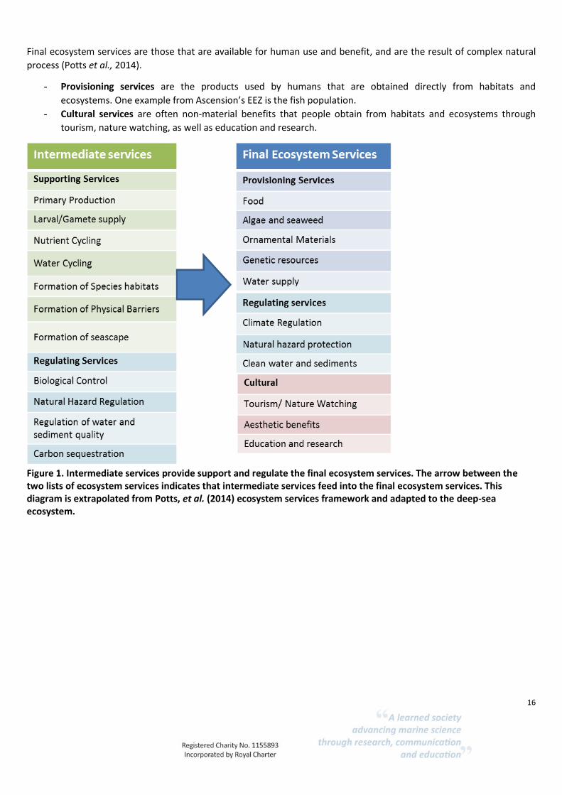
To assess ecosystem goods and services provided by the deep-sea, the Potts et al., (2014) framework was adopted
which categorises ecosystem services into four main groups (Fig. 1). The list of services outlined by Potts et al., (2014)
has been modified and tailored to Ascension Island deep-sea habitats based on expert knowledge. Descriptions of the
ecosystem services with deep-sea examples are provided in Annex 2.
Intermediate services relate to ecological function and support final ecosystem services (Potts et al., 2014).
Intermediate services such as primary production, nutrient cycling, formation of species habitat and larval / gamete
supply generate the final ecosystem services, such as the provisioning of fish and algae. Hence, intermediate and final
ecosystem services are important to provide e.g. food as a good/benefit for humans. To understand the correlation
between intermediate services and final ecosystem services, Fig. 2 provides an example of such interaction.
Intermediate services are:
- Supporting services, which are functions necessary for the production of all other ecosystem services
(Armstrong, et al., 2012); as this type of service feeds into provisioning, regulating and cultural services and
enter into the human well-being indirectly. For example, in Ascension Island one of the supporting services is
the formation of cold-water coral reefs that provide a three-dimensional structure where fish find ideal
conditions for spawning, feed and hide from predators.
- Regulating services provide benefits derived from the natural regulation of habitats and ecosystem processes,
such as natural carbon sequestration and storage, biological control, regulation of water and sediment type. In
Ascension’s EEZ carbon sequestration is one example of an ecological process provided by the deep-sea fauna
that facilitates carbon regulation through burial in deep sediments via bioturbation.
16
Final ecosystem services are those that are available for human use and benefit, and are the result of complex natural
process (Potts et al., 2014).
- Provisioning services are the products used by humans that are obtained directly from habitats and
ecosystems. One example from Ascension’s EEZ is the fish population.
- Cultural services are often non-material benefits that people obtain from habitats and ecosystems through
tourism, nature watching, as well as education and research.
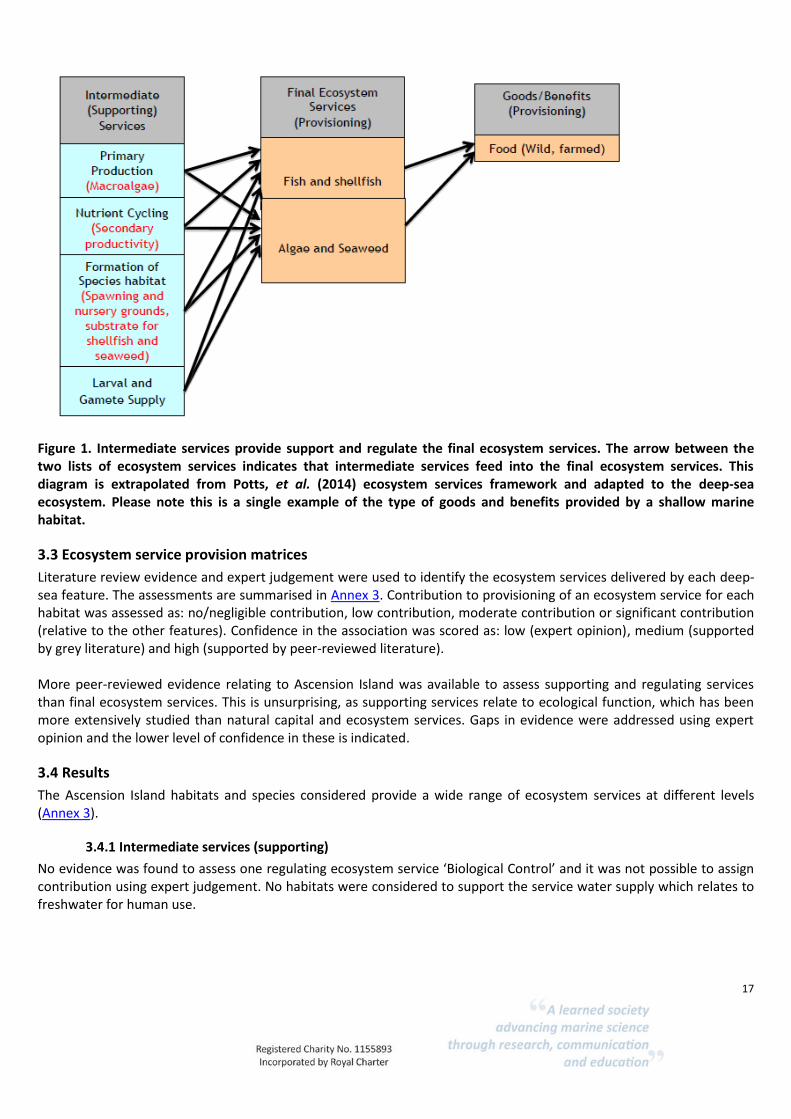
Figure 1. Intermediate services provide support and regulate the final ecosystem services. The arrow between the two lists of ecosystem services indicates that intermediate services feed into the final ecosystem services. This diagram is extrapolated from Potts, et al. (2014) ecosystem services framework and adapted to the deep-sea ecosystem.
17
Figure 1. Intermediate services provide support and regulate the final ecosystem services. The arrow between the two lists of ecosystem services indicates that intermediate services feed into the final ecosystem services. This diagram is extrapolated from Potts, et al. (2014) ecosystem services framework and adapted to the deep-sea ecosystem. Please note this is a single example of the type of goods and benefits provided by a shallow marine habitat.
3.3 Ecosystem service provision matrices
Literature review evidence and expert judgement were used to identify the ecosystem services delivered by each deep-sea feature. The assessments are summarised in Annex 3. Contribution to provisioning of an ecosystem service for each habitat was assessed as: no/negligible contribution, low contribution, moderate contribution or significant contribution (relative to the other features). Confidence in the association was scored as: low (expert opinion), medium (supported by grey literature) and high (supported by peer-reviewed literature). More peer-reviewed evidence relating to Ascension Island was available to assess supporting and regulating services than final ecosystem services. This is unsurprising, as supporting services relate to ecological function, which has been more extensively studied than natural capital and ecosystem services. Gaps in evidence were addressed using expert opinion and the lower level of confidence in these is indicated.
3.4 Results
The Ascension Island habitats and species considered provide a wide range of ecosystem services at different levels (Annex 3).
3.4.1 Intermediate services (supporting)
No evidence was found to assess one regulating ecosystem service ‘Biological Control’ and it was not possible to assign contribution using expert judgement. No habitats were considered to support the service water supply which relates to freshwater for human use.
18
The deep-sea provides significant supporting services, which sustain ecosystem function and delivery of final ecosystem services, thus contributing to human well-being. All of the deep-sea and intertidal habitats were considered to contribute to the supporting services: larval and gamete supply, nutrient cycling, formation of species habitats, formation of physical barriers and formation of seascape. Primary production within deep-sea sedimentary benthic habitats was considered to be low, based on expert opinion. Most organisms that live in the deep-sea benthic ecosystems depend on organic matter inputs from the pelagic zone (Ramirez-Llodra et al., 2010). Seamounts enhance primary production through nutrient upwelling (Rogers et al., 2018, Van Dover et al., 1996) and studies from other regions have found that increased primary production appeared to support higher planktonic- and consumer biomass than surrounding waters (Clark et al., 2009). Additional, aphotic primary production represents an important ecosystem service provided by chemosynthetic organisms that are found living in and around vents, as well as explosive mud volcanoes and cold seeps. These organisms contribute to the marine oxidation of methane, which reduces geological and biological methane release, promoting carbonate precipitation and habitat formation (Thurber et al., 2014). All deep-sea features contribute to habitat provision and formation of seascapes and some key examples are outlined below:
Seamounts, as well as hydrothermal vents, host a number of special communities and organisms that are found nowhere else in the marine environment (Taranto et al., 2012). Irving (2015) and Wirtz et al., (2014) identify eleven fish species endemic to the Ascension Island and a further 16 species that are shared endemics with St Helena Island.
Cold-water coral reefs are one of the best-known examples of biogenic habitat that form complex structures,
supporting biodiversity and ecosystem functioning in a wide range of deep-sea ecosystems (Thurber et al., 2014).
Whale falls (sinking dead whales), will create habitats that support communities dependent on the cetacean
carcass (Irving, 2015, Thurber et al., 2014). Over a decade, a range of scavenger species will use part of the whale as energy source and the bones will act as hard substrate for filter feeders to attach to (Thurber et al., 2014).
Hydrothermal vents host unique high-density faunal communities with elevated levels of endemism that appear
to grow with increasing depth (Thurber et al., 2014). A generally positive interaction between diversity and ecosystem functioning, in particular, the biodiversity found in the hydrothermal vents is considered necessary for the production of all other services, including primary production and nutrient cycling (Thurber et al., 2014).
3.4.2 Regulating: intermediate and final services
Less supporting evidence was found to assess the contribution of Ascension Island’s habitats to regulating services. Deep-sea habitats are likely to support carbon sequestration contributing to climate regulation. Within deep-sea soft sediment areas, benthic infauna facilitates the burial of carbon in deep sediments via bioturbation (function), and contributes to carbon sequestration and climate regulation (service) (Le et al., 2017). There have been very few studies regarding the role of cold-water corals in carbon and nutrient remineralisation. However, a study based in the Rockall Trough showed much of the carbon sequestration was regulated by fauna and bacteria associated with dead coral substrate, which makes up a large part of the reef structures (White et al., 2012). The rates of carbon sequestration and the contribution of habitats to other regulating services is not clear. Habitats with rough terrain, including seamounts, ridges and cold-water coral reefs were considered likely to contribute to natural hazard protection.

19
3.4.3 Final ecosystem services (provisioning)
A limited number of habitats (A6.3 deep-sea sands, A6.61 deep-sea coral communities and some habitats within A6.7 raised features of the seabed) contribute ornamental materials (and it should be noted that over collection of these may result in detrimental impacts and resource depletion). In terms of non-living materials, some deep-sea and seamount habitats are associated with metals that can be mined. For instance, precipitates can form hard substrates, which may contain cobalt, nickel, platinum, thallium and tellurium, and are often found at 800-2500 m water depth (Le et al. 2017). Some of these metals are used for photovoltaic solar cells, hydrogen fuel cells, electric car batteries, computer chips, cell phones and other technology (Le et al. 2017). Expert knowledge, however, suggests that metal crusts and manganese nodules are unlikely to have formed at Ascension Island (K. Howell, pers. comm.). Some organisms found on seamounts have supported the developments of novel biomaterials such as bamboo corals as models for synthetic human bone replacements and sponge spicules as superconductors for light (Le et al. 2017). The provisioning of genetic material could also be a key ecosystem service, but development is uncertain and unpredictable. All habitats could provide genetic resources for research and product development. Hydrothermal vents may be of particular value as they host organisms that are able to cope with extreme environmental conditions (Van Dover, et al. 2014). Some of these organisms are considered to be genetically useful for drug, enzyme, cosmetic, biofuel and other product developers (Van Dover et al. 2014). The collection of limited quantities of bacteria and archaea is often conducted during scientific research for initial gene or product discovery (Van Dover et al. 2014). Vents have low contribution to the rest of the provisioning services, and little or no data were found for this particular service. Sustaining fish populations is a key ecosystem service provided by Ascension Island habitats and yet the ecological functions that might support the fish population are still poorly understood. However, there is evidence that the fish communities living on seamounts are supported by the abundance of prey species and the structural complexity of the habitat which allows fish to hide when they are not hunting (Morato et al., 2009). Moreover, complex coral and sponge habitats provide spawning- and nursery grounds for associated fish species (Buhl-Mortensen et al., 2010) A few studies show that many of the species associated with Lophelia reefs are commercially fished (Hall-Spencer et al. 2002; Costello et al., 2005). Cold-water coral reefs are thus considered to make moderate and high contributions to provisioning services.
3.4.5 Final ecosystem services (cultural)
The intertidal habitats on Ascension Island currently deliver a range of cultural services. The beaches and rocky shores provide space for a range of recreational activities, such as shore fishing, which is particularly popular. Conservation and management of intertidal habitats offers volunteering- and work opportunities through surveying, monitoring work, scientific surveys and other associated activities. Ascension’s marine ecosystem is considered to be able to support further cultural service development around education, scientific research and tourism. The presence of turtle nesting beaches presents an opportunity to further foster scientific research, education and tourism programmes. Cetaceans have been recorded within the EEZ (Irving, 2015) and these also have the potential to support wildlife watching tourism introducing a new economic benefit to the area.

20
Chapter 4 Vulnerability Assessment
4.1 Human activities and pressures
Activities in the marine environment result in a number of pressures, which may impact sensitive environmental components. Pressures are defined as ‘the mechanism through which an activity has an effect on any part of the ecosystem’ (Robinson et al., 2008). Pressures can be physical, chemical or biological (see Table 3 for major pressure categories) and may be direct, such as the removal of target species by a fishery or the noise produced by a boat engine that can disturb birds and marine mammals, or indirect and experienced further afield than the pressure source, such as changes in temperature caused by global climate change. Impacts are defined as the consequences of these pressures where a change occurs that is different to that expected under natural conditions. The same pressure can be caused by a number of different activities, so that fishing with bottom gear and aggregate dredging both cause abrasion, which is a habitat damage pressure (Robinson et al., 2008). Different pressures can cause the same impact, for example, habitat loss and habitat structure changes can both result in the mortality of animals living on the seabed (Robinson et al., 2008). Understanding the links between the activities and the pressures that they cause is the first step in helping to identify potential impacts on coastal and marine environments. For the vulnerability assessment, we used an internationally recognised list of marine pressures (grouped as pressure themes) and their descriptions prepared by the OSPAR Intercessional Correspondence Group on Cumulative Effects (ICG-C). The list of pressures is published within OSPAR Agreement 2014-02 ‘OSPAR Joint Assessment and Monitoring Programme (JAMP) 2014-2021’ (Table 3).
Table 3. Pressure themes and the related pressures.
Pressure theme ICG-C1 Pressure
Hydrological changes Salinity changes;
Temperature changes;
Water flow (tidal current) changes; and
Wave exposure changes.
Pollution and other chemical changes
Organic enrichment
Physical loss (permanent change) Physical change (to another seabed type)
Physical damage (reversible change)
Abrasion/disturbance of the substratum on the surface of the seabed; Penetration and/or disturbance of the substratum below the surface of the seabed; Changes in suspended solids (water clarity); Removal of substratum (extraction); Siltation rate changes, including smothering; and Physical change (to another seabed type).
Other physical pressures Electromagnetic changes Introduction of light
1 ICG-C (Intercessional Correspondence Group on Cumulative Effects)

21
Biological pressures Introduction or spread of non-indigenous species (NIS); Removal of non-target species; Removal of target species
A useful tool to link the pressures to activities is the pressures-activities database (PAD) developed by JNCC2 which compiled the evidence base for the relationships between 112 marine-based human activities and their associated pressures (based on the OSPAR pressure list). The JNCC PAD is a starting point to identify which pressures may be caused by which activities, and gives an indication of the general risk the pressures pose to the environment under normal conditions.
4.2 Vulnerability and risk assessment.
The degree of vulnerability of a habitat or species is a product of sensitivity and exposure. A habitat, community or species becomes ‘vulnerable’ to adverse effect(s) when it is sensitive and the external factor is likely to happen (Holt et al., 1995, Tyler-Walters et al., 2001). If a component is not sensitive to a pressure then it is not vulnerable. For example, a certain habitat type may be highly sensitive to fishing activities, but if it occurs in an area where there is no fishing activity, it would not be vulnerable. Alternatively, a habitat that is less sensitive to fishing activities in an area where it is repeatedly exposed to fishing, is vulnerable to some degree. The most vulnerable ecosystems are those that are both, easily disturbed and very slow to recover; or they may never recover. Vulnerability can be thought of as a risk assessment that considers the severity of risk (the level of impact) and the likelihood of the risk occurring.
4.3 Sensitivity
The UK Review of Marine Nature Conservation (Defra 2004) defined sensitivity as ‘dependent on the intolerance of a species or habitat to damage from an external factor and the time taken for its subsequent recovery’. Intolerance was defined as the ‘susceptibility of a habitat, community or species to damage, or death, from an external factor’, and recoverability is the ‘ability of a habitat, community or species to return to a state close to that which existed before the activity or event caused change’ (Hiscock and Tyler-Walters, 2006). Subsequent sensitivity assessments have considered these two elements of sensitivity separately, as resistance or tolerance and recovery or resilience. Highly sensitive habitats or species are those with both low resistance and resilience. Species will differ in their ability to resist different types of pressures based on the type of pressure, the extent, duration and magnitude of the pressure, and the degree of exposure. The timing of the pressure exposure can also be significant, in relation to species’ life cycles, reproduction, recruitment or even season or time of day with some species active and/or present in different areas at different times. Different life stages of an organism may also vary in tolerance to pressures. Sensitivity assessments are more meaningful when assessed using a benchmark for the pressure.
4.4 Pre-existing sensitivity assessments.
Developing evidence-based assessments is time consuming and resource intensive. For this project we used existing sensitivity assessments to assess vulnerability where these are available. Existing assessments were identified using a rapid, systematic literature review. To date the development of sensitivity assessments for use by managers has focussed on coast and shallow marine habitats and fewer assessments are available for deep-sea habitats. Two key sources used for this project are the sensitivity matrix developed to support marine protected area management in the UK (Project MB0102, Tillin et al., 2010), and the intertidal marine evidence-based sensitivity assessments (MarESA) developed by the Marine Life Information Network (MarLIN) and available on their website3. Project MB0102 used expert judgement at workshops to
2 http://jncc.defra.gov.uk/default.aspx?page=7136 3 https://www.mba.ac.uk/projects/marlin-marine-life-information-network

22
create sensitivity assessments while the MarESA assessments have been produced later and are based on evidence review. The following assessments developed by Project MB0102 have been used in this project.
Deep-sea bed A6;
Deep-sea rock and artificial hard substrata A6.1;
Deep-sea mixed substrata A6.2;
Deep-sea sand A6.3;
Deep-sea muddy sand A6.4;
Deep-sea mud A6.5;
Deep-sea bioherms A6.6;
Raised features of the deep-sea bed A6.7 A number of pressures that were not considered relevant to deep-sea habitats were removed (see Table 4).
Table 4. Pressures excluded from the vulnerability assessment.
Pressure Basis for exclusion
Changes in emergence regime Not relevant to deep-sea habitats
Underwater noise changes Electromagnetic changes; Barrier to species movement; Death and injury by collision
Species pressures not relevant to habitats
Litter Pressure not assessed as no pressure benchmark has been developed
Non-synthetic compound contamination (incl. heavy metals, hydrocarbons, produced water); Synthetic compound contamination (incl. pesticides, anti-foulants, pharmaceuticals); Introduction of other substances (solid, liquid or gas)
All non-sensitive at the pressure benchmark which was set at compliance with all existing standards;
Microbial pathogens Introduction of non-native species
Evidence base too poorly developed to assess these.
During the course of a Census of Marine Life SYNDEEP workshop, a group of 23 deep-sea researchers developed a scoring system to grade the effect of 28 major anthropogenic impacts, classified as disposal, exploitation and climate change/oceanic acidification impacts on deep-sea habitats. The group considered likely, past, present and future levels of impact. In the present study, we used the future impact scores to assess likely vulnerability (Ramirez-Llodra et al., 2011).
4.5 Results
4.5.1 Sensitivity assessments for deep-sea habitats: evidence gaps and key limitations
Due to methodological differences, including differences in pressure/activity categorisation, pressure benchmarks and sensitivity scales the assessments developed using different approaches are presented separately (MB0102 and MarESA sensitivities in Tables 23 and 24, respectively, Annex 3) and the smaller assessment tables based on Ramirez-Llodra et al. (2011) in Tables 5 and 6 below and within the case studies. The lack of available sensitivity assessments for deep-sea habitats reflects the generally low level of understanding and research on deep-sea habitats. Compared to shelf habitats, the deep-sea is less accessible and costlier. Ecological studies on life-history traits, habitat and population connectedness and recovery rates are key information gaps to assess sensitivity (as they do in coastal habitats and shelf seas).

23
Research effort is typically focussed on widespread activities that are likely to be of concern and that are commercially important. Hence, fishing and associated physical damage pressures are better understood than other activities that are more limited in extent and intensity. The impacts of physical damage are also more predictable. It is clear that fragile features that rise above the seabed are more likely to be removed by physical abrasion than deeply buried features and that a complex habitat created by living organisms will be more sensitive to abrasion than bare rock. The pathways by which other pressures impact species and habitats are less predictable and thus it is harder to identify what the impacts may be. A further factor influencing evidence availability for sensitivity assessments, is whether impacts are direct and localised (such as abrasion from a trawl) or indirect with potentially far reaching effects. A direct impact can be assessed using targeted surveying and monitoring, while indirect and far field effects are much less tractable, such as the loss of a targeted species in a biological community or the fate of chemical pollutants released into the environment. Climate change effects, such as increased temperatures, ocean acidification as well as increased stratification are considered likely to result in significant changes to ecosystems. However, predicting when these changes will happen, and how severe these will be, is problematic because species’ tolerances are not fully known. Some species may acclimate or have other adaptive mechanisms, but changes in complex, dynamic communities may have unforeseen ramifications.
4.5.2 Activities and pressures that may result in impacts on deep-sea habitats
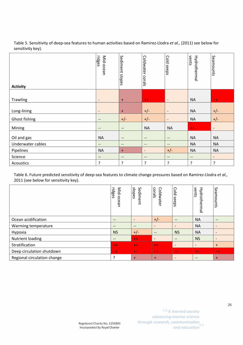
The best-studied deep-sea ecosystem sensitivity to date is the impact of physical damage from abrading and penetrating activities on cold-water coral reefs and sponge aggregations (see Case study 2). Cold-water coral reefs and sponge aggregations have been identified as ‘Vulnerable Marine Ecosystems’ by the United Nations General Assembly (UNGA) Resolution 61/105 (FAO, 2009). Vulnerability is based on the importance of their function, rarity and their sensitivity (based on fragility and low recovery), as well as their exposure to fishing activities using gears that come into contact with the seabed. The sensitivity of other habitat types and activities has been less studied. Human activities, besides fishing, have largely impacted coastal habitats and shelf seas or have mostly been studied in these areas. There is no direct evidence to assess sensitivity and vulnerability of deep-sea habitats from Ascension Island. The SYNDEEP workshop assessments identified deep-sea ecosystems that experts believe to be at higher risk from human impacts in the near future: benthic communities on sedimentary upper slopes, cold-water corals, canyon benthic communities and seamount pelagic and benthic communities (Ramirez-Llodra et al., 2011). While acknowledging the limitations of this approach (see Chapter 5), the results of expert opinion indicate that human activities that lead to direct physical damage pressures, such as trawling and mining and the laying of pipelines are likely to impact those habitats characterised by epifauna (seamounts and coldwater coral reefs), and to a lesser extent, sediment slopes (Table 5). Mining was identified as likely to cause high impacts on hydrothermal vents. The lower sensitivity of other habitats shown in table 5 is considered to be due to the lack of exposure of these habitats to mining activities, not a lack of sensitivity. The MB0102 assessments based on expert opinion and the MarESA assessments also identify that deep-sea habitat sensitivity to physical damage pressures is likely to be high. Ramirez-Llodra et al., (2011), predicted that future climate change is likely to result in severe impacts on habitats through changes in stratification and circulation. Many observational studies are showing that present day climate change is already impacting deep-sea environments, as evidenced by increased deep-sea temperature, deoxygenation, lowered pH of intermediate deep-waters and altered flows of organic matter to the seafloor (Sweetman et al., 2017 and references therein). Our understanding of the extent to which projected physical and chemical changes will lead to impacts is still very poor (Philippart et al., 2011). The MB0102 sensitivity assessments identified that a number of habitats would have medium sensitivity to temperature changes at the pressure benchmark but these were largely based on cold-water corals. For most habitats no available assessments considered the effects of nutrient and organic enrichment and siltation pressures. These pressures have been little studied, with the exception of some research on the effects of sewage dumping at high intensities as most deep-sea habitats are likely to be remote from activities such as coastal dumping of
24
sewage, dredge spoil and aggregate dredging that may result in these pressures. Local habitat conditions will influence the level of pressure experienced, in areas with high currents deposits of organic matter and deposited sediments are likely to be rapidly removed mitigating effects. In more stable areas with lower currents, such as deep-sea muds, deposits are more likely to accumulate and result in habitat changes. Activities that result in increased nutrients, organic matter (including sewage), or siltation could result in removal of deposits by wave action and redeposition in deep-sea habitats.
4.5.3 Human activities and pressures that are unlikely to result in direct impacts on deep-sea habitats
Organic enrichment and sedimentation are considered unlikely to affect Ascension Island habitats unless there was a large increase in population and sewage disposal at sea. Organic enrichment is frequently associated with fish aquaculture but this activity does not occur around Ascension Island and the high levels of wave exposure probably preclude this activity. Recreational activities can alter habitats and disturb species. No recreational activities are likely to directly impact deep-sea habitats and these are considered not to be exposed and not vulnerable to tourism. An increase in tourism and recreation will not directly impact deep-sea benthic habitats through noise or visual disturbance, however, indirectly increased visitor numbers may result in increased litter. Petrochemical spills are the only significant coastal marine pollution threat on Ascension Island. However, regular pipeline maintenance, routine inspections during fuel transfer and operating procedures that reduce risk mean that the probability of a substantial spill is very low (AIG 2015d). Lighter oil fractions generally float on the surface although vertical mixing may result in some sediment exposure. Intertidal sandy beaches on Ascension Island (AIG, 2015b) are threatened by the establishment of non-native species that could result in physical change and loss of the habitat. Non-native species have not been identified as a present threat to subtidal and deep-sea habitats but this situation could of course change depending on accidental or deliberate introductions. Marine invasive species may be transported by shipping, either in ballast water or as fouling organisms, however, these vectors transport attached fouling species are more likely to transport organisms suited to life in upper sea surface layers, or intertidal and shallow subtidal species, rather than deep-sea species.
4.5.4 Human activities and pressures likely to lead to deep-sea impacts in Ascension Island
The most widespread and damaging human pressure exerted on deep-sea habitats globally is physical damage caused by fishing gear that comes into contact with the seabed. Habitats characterised by fragile, erect species with long recovery rates, such as reefs of deep-sea sponges and the coral L. pertusa are highly sensitive to this pressure. As deep-sea trawls are not used around Ascension Island, none of the deep-sea habitats are vulnerable to this pressure. Climate change may already be impacting deep-sea ecosystems around Ascension Island and future effects and consequences are a key evidence gap. Deep-sea ecosystems have been identified as likely to be severely impacted by climate change pressures (Ramirez-Llodra et al., 2011, Sweetman et al., 2017). Of particular concern are cold-water coral reefs (see Case study 2). Benthic communities are predicted to be sensitive to water column stratification that would result in lower oxygen levels and depletion in phytoplankton food supply (see Table 6). These impacts could ramify through the food web resulting in impacts on larger, mobile predatory species such as fish, altering the level of supporting, provisioning and cultural services.
25
Table 5. Sensitivity of deep-sea features to human activities based on Ramirez-Llodra et al., (2011) see below for sensitivity key).
Activity
Mid
-ocean
rid
ges
Sedim
ent slo
pes
Co
ldw
ater corals
Co
ld seep
s
Hyd
roth
ermal
vents
Seamo
un
ts
Trawling - + ++ - NA ++
Long-lining - + +/- - NA +/-
Ghost fishing -- +/- +/- - NA +/-
Mining -- -- NA NA ++ -
Oil and gas NA -- -- -- NA NA
Underwater cables -- -- -- -- NA NA
Pipelines NA + - +/- NA NA
Science -- -- -- -- -- -
Acoustics ? ? ? ? ? ?
Table 6. Future predicted sensitivity of deep-sea features to climate change pressures based on Ramirez-Llodra et al., 2011 (see below for sensitivity key).
Mid
-ocean
ridges
Sedim
ent
slop
es
Co
ldw
ater co
rals
Co
ld seep
s
Hyd
roth
ermal
vents
Seamo
un
ts
Ocean acidification -- - +/- -- NA --
Warming temperature -- -- - - NA -
Hypoxia NS +/- -- NS NA -
Nutrient loading -- ++ - -- NS -
Stratification ++ ++ ++ - - +
Deep circulation shutdown ++ ++ ++ ++ ++ ++
Regional circulation change ? + + - -- +
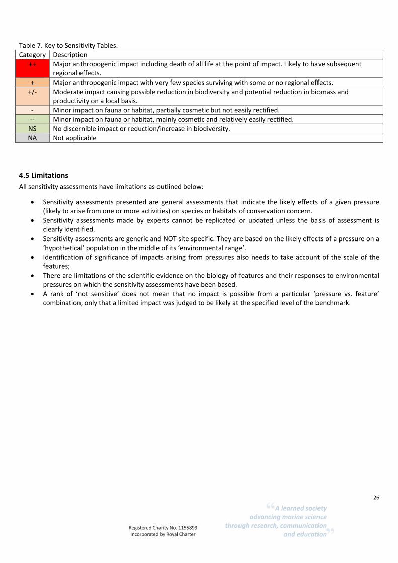
26
Table 7. Key to Sensitivity Tables.
Category Description
++ Major anthropogenic impact including death of all life at the point of impact. Likely to have subsequent regional effects.
+ Major anthropogenic impact with very few species surviving with some or no regional effects.
+/- Moderate impact causing possible reduction in biodiversity and potential reduction in biomass and productivity on a local basis.
- Minor impact on fauna or habitat, partially cosmetic but not easily rectified.
-- Minor impact on fauna or habitat, mainly cosmetic and relatively easily rectified.
NS No discernible impact or reduction/increase in biodiversity.
NA Not applicable
4.5 Limitations
All sensitivity assessments have limitations as outlined below:
Sensitivity assessments presented are general assessments that indicate the likely effects of a given pressure (likely to arise from one or more activities) on species or habitats of conservation concern.
Sensitivity assessments made by experts cannot be replicated or updated unless the basis of assessment is clearly identified.
Sensitivity assessments are generic and NOT site specific. They are based on the likely effects of a pressure on a ‘hypothetical’ population in the middle of its ‘environmental range’.
Identification of significance of impacts arising from pressures also needs to take account of the scale of the features;
There are limitations of the scientific evidence on the biology of features and their responses to environmental pressures on which the sensitivity assessments have been based.
A rank of ‘not sensitive’ does not mean that no impact is possible from a particular ‘pressure vs. feature’ combination, only that a limited impact was judged to be likely at the specified level of the benchmark.

27
Case study 1. Deep-sea benthic habitats.
CS 1.1 Description and evidence for presence in Ascension Island.
A review of the benthic habitats in the Economic Exclusive Zone (EEZ) of Ascension Island found very little information and therefore, the generalized description of benthic habitats given here are not necessarily specific to the Ascension Island. Yet, most of the biological and physical patterns are considered applicable. This case study considered the EUNIS habitat categories in Table 8. The ecosystem services delivered by these habitats are identified in the ecosystem service matrix (Annex 3).
Table 8. EUNIS habitat categories for deep-sea benthic habitats.
EUNIS code 2007 EUNIS level EUNIS name 2007
A6.1 3 Deep-sea rock and artificial hard substrata
A6.11 4 Deep-sea bedrock
A6.14 4 Boulders on the deep-sea bed
A6.2 3 Deep-sea mixed substrata
A6.22 4 Deep-sea biogenic gravels (shells, coral debris)
A6.3 3 Deep-sea sand
A6.4 3 Deep-sea muddy sand
A6.5 3 Deep-sea mud
Notes: See Annex 3 for ecosystem services matrix.
The geological, physical and geochemical settings of the deep-sea floor form a series of different habitats with unique characteristics and specific faunal communities (Ramirez-Llodra et al., 2010). In geomorphological terms, Ascension Island is an intra-plate volcanic island and is located 90 km west of the Mid-Atlantic Ridge, which has a major influence on the circulation of near-bottom water masses (Irving, 2015). On Ascension Island, Nolan, et al. (2017) showed that the average density of benthic fauna increased with substratum roughness, which is a common scenario in benthic systems (Thrush et al., 2002).
The geographical patterns of Ascension Island have been poorly investigated, however photographic images and CTD deployments contributed to a better understanding of the benthic habitat types and faunal assemblages found across both northern and southern of Ascension Island (Nolan et al., 2017). In terms of substratum types, photographic transects using a shelf underwater camera system (SUCS) found considerable faunal diversity inhabiting hard substrata, including rocks and boulders/bedrock on the majority of photos. Nolan et al. (2017) investigated the relationship between faunal assemblages and substratum and showed that the faunal assemblages were influenced by depth and the type of coarse sand and large pebbles. These faunal assemblages from the Ascension benthic systems are described in table 9.

28
Table 9. Faunal assemblages recorded by Nolan et al. (2017).
Faunal assemblages Extent Further information
Black corals (Antipatharia sp.) (Fig. 3-A)
Unknown, probably widespread in shallow
sites.
Abundant in shallowest sites, particular high cover was sampled in complex rocky substratum, associated with encrusting sponges
Sessile and mobile species
Unknown One of the sessile species identified was the sea pen Virgularia sp., found predominantly on coarse sediment and therefore a clear association between species and substratum type is evident
Sabellid polychaetes (Fig.3 –E)
Unknown Found predominantly on hard substrata.
Lophelia pertusa (Fig. 3-D)
Unknown, possibly widespread
Classified as one of the Vulnerable Marine Ecosystems (see Cold-water corals Case Study 2 pp. 29)
Nematocarcinid shrimps (Fig.3 – F)
Unknown Observed on transects at greater depths, particularly deeper than 500m.
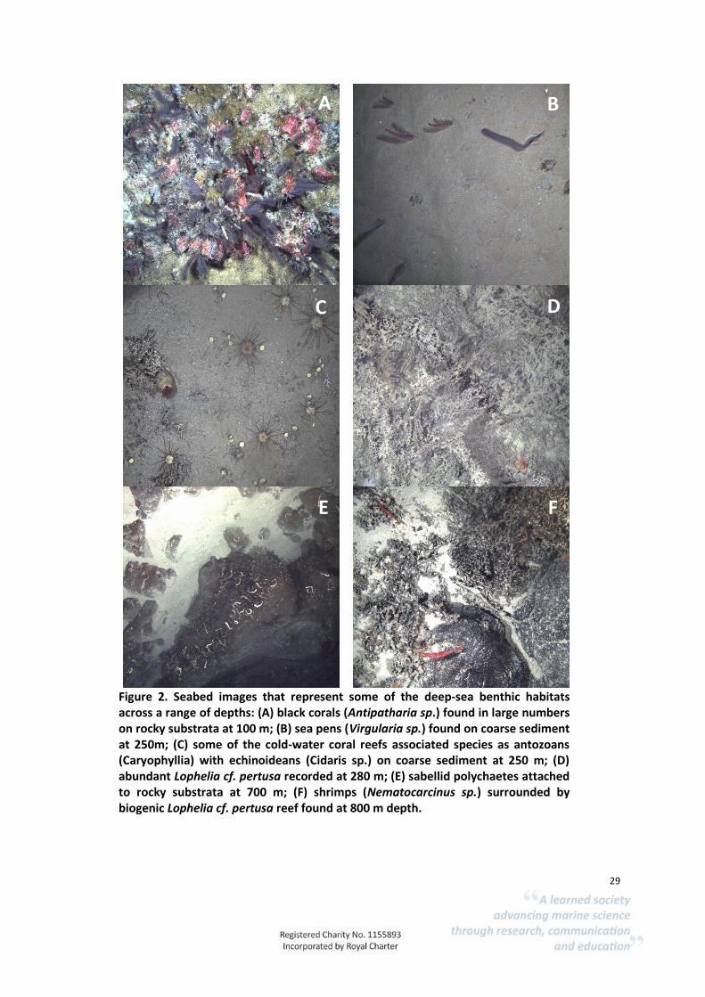
29
Figure 2. Seabed images that represent some of the deep-sea benthic habitats across a range of depths: (A) black corals (Antipatharia sp.) found in large numbers on rocky substrata at 100 m; (B) sea pens (Virgularia sp.) found on coarse sediment at 250m; (C) some of the cold-water coral reefs associated species as antozoans (Caryophyllia) with echinoideans (Cidaris sp.) on coarse sediment at 250 m; (D) abundant Lophelia cf. pertusa recorded at 280 m; (E) sabellid polychaetes attached to rocky substrata at 700 m; (F) shrimps (Nematocarcinus sp.) surrounded by biogenic Lophelia cf. pertusa reef found at 800 m depth.
A B
C D
E F

30
CS 1.2 Ecosystem function and associated services and benefits.
The key services provided by the benthic habitats are identified in Annex 3. Due to limited evidence the level of contribution of each service for habitat is based on expert opinion. It is key to highlight that the importance of biodiversity in regulating the ecosystem functions is essential for the production of natural goods and services (Zeppilli et al., 2016). In the deep-sea, Leduc et al. (2013) argues that species diversity has a positive influence on ecosystem functioning and that most species contribute to at least some contexts of the ecosystem functioning. Danovaro et al. (2008) shows that the exponential relationships between deep-sea biodiversity and ecosystem functioning are consistent across a wide range of bottom-water temperatures and trophic conditions and reflect interactions between organismal life and deep-sea ecosystem processes occurring at a global scale. There is evidence that changes in species diversity is associated with ecological functional alterations (Danovaro et al., 2008). However, evidence for explicit links between biodiversity and ecological function (supporting services) and provision of goods and benefits is currently poor and levels of service contribution are uncertain. The ecosystem services associated with benthic habitats are:
Supporting services: Primary production Larval and gamete supply Nutrient cycling Formation of species habitats Formation of physical barriers Formation of seascape
Regulating services: Regulation of water and sediment quality Carbon sequestration Natural hazard protection Clean water and sediments Climate regulation
Provisioning services: Fish and shellfish Genetic resources
Cultural services: Tourism/nature watching Aesthetic benefits Education
CS 1.2.1 Supporting and provisioning services
Primary production within benthic habitats is considered to provide a low contribution based on expert opinion. Most organisms that live in the deep-sea benthic ecosystems depend on organic matter inputs from the pelagic zone that sink through the water column (Ramirez-Llodra et al., 2010). Higher productivity occurs along mid oceanic ridges and continental margins and associated with large food falls such as whale carcasses, kelp or wood (Armstrong et al., 2012, Ramirez-Llodra et al., 2010).

31
Nutrient cycling is considered to provide a moderate contribution to the regional nutrient cycling for the deep-sea benthic communities, judged by expert knowledge. At a local level, the presence of mobile species is likely to play a major role in nutrient cycling by other organisms. For instance, organic matter (e.g. faecal pellets) from pelagic species falling from the euphotic zone, will be decomposed by aerobic bacteria and then consumed by zooplankton as it sinks (Irving, 2015).
CS 1.2.2 Regulating services
Ascension Island’s EEZ supports deep-sea soft sediment habitats. Within these areas, deep-sea infauna plays an important role as bioturbators, enhancing nutrient cycling and contributing to the circulation of nutrients (Weslawski et al., 2004). By facilitating the burial of carbon in deep sediments burrowing infauna contribute to carbon sequestration and climate regulation (Le, et al., 2017).
CS 1.2.3 Provisioning services
Very little information was found on the contribution of the provisioning services. Based on expert opinion, A6.11 deep-sea bedrock, A6.14 boulders and A6.2 mixed substrata, A6.22 biogenic gravels and A6.3 deep-sea sand do not contribute to the provision of algae and seaweed, ornamental materials and water supply. No information was found on the interaction between fish and shellfish population with the deep-sea hard, mixed and sand substrata. However, to understand the link between the reef community and fish, see Case study 2 Cold-water coral reefs L. pertusa.
CS 1.2.4 Cultural services
A6.11 deep-sea bedrock and A6.14 boulders on the deep-sea bed contribute strongly to the cultural services (expert opinion). Wildlife watching and sport fishing have a strong potential to provide economic benefits to the island (based on expert opinion) and these may be directly or indirectly supported by deep-sea habitats through supporting services.
CS 1.3 Vulnerability of these services to human pressures
Physical pressures that remove, change or damage the habitat are likely to reduce suitability for many invertebrate species; this could then reduce biodiversity and threaten ecosystem function. Examples of human activities that can disturb the bottom include bottom trawling and dredging and cable and pipeline laying (Table 10). No evidence was available to assess the likely impacts of climate change, hydrological or chemical pressures. Ramirez-Llodra et al. (2011) and Sweetman et al. (2017) have identified that climate change pressures including oceanic stratification may cause significant impacts in the future (Table 10). Benthic communities are predicted to be sensitive to water column stratification that would result in lower oxygen levels and depletion in phytoplankton food supply. These impacts could ramify through the food web resulting in impacts on larger, mobile predatory species such as fish, altering the level of supporting, provisioning and cultural services.

32
Table 10. Future predicted sensitivity of sediment slopes to human activities and climate change pressures based on Ramirez-Llodra et al., 2011 (Key to symbology, ++ major impact with likely regional effects, + major impact with some or no regional effects, +/- moderate local impact, - minor impact with low recovery, -- minor impact with recovery, NS- not sensitive, NA- not applicable (see Table 7 for fuller description of sensitivity categories).
Activity
Trawlin
g
Lon
g-linin
g
Gh
ost fish
ing
Min
ing
Oil an
d gas
Un
derw
ater cables
Pip
elines
Science
Oce
an acid
ification
Warm
ing tem
peratu
re
Hyp
oxia
Nu
trient lo
adin
g
Stratification
Dee
p circu
lation
sh
utd
ow
n
Regio
nal circu
lation
chan
ge
Sedim
ent
slop
es + + +/- -- -- -- + -- - -- +/- ++ ++ ++ +
CS 1.4 Summary
Based on the data analysis and expert knowledge, the benthic habitats present in Ascension Island deep-sea waters are deep-sea bedrock, boulders and sand. Deep-sea muddy sand and deep-sea mud including abyssal muds are likely to be present but are not confirmed. All habitats were considered to contribute to all supporting services at different degrees. Final services were poorly documented, and expert opinion suggested that no benthic habitats were considered to contribute to the water cycling service, natural hazard regulation, algae and seaweed or ornamental materials. Cultural services are associated with deep-sea habitats through the potential to support research and education and public engagement activities. Overall, the literature review highlighted the importance of species diversity that could be found on benthic habitats to support the delivery of ecosystem services. The vulnerability assessment identified that deep-sea benthic habitats are sensitive to physical damage and climate change pressures. Currently no human activities are causing physical damage but any future proposals to introduce damaging activities should be risk-assessed. Climate change cannot be directly managed and deep-sea habitats around Ascension Island are vulnerable.

33
Case study 2. Cold-water coral reefs of Lophelia pertusa.
CS 2.1 Description and evidence for presence in Ascension Island
Ascension Island harbours cold-water coral reefs which are formed by L. pertusa, a common scleractinian coral species in the Atlantic (Nolan et al., 2017). At Ascension Island, the densest reef patches were recorded at depths > 350 m (Nolan et al., 2017). There is high confidence in the presence of this feature and it may be widespread in the Ascension Island’s EEZ. The ecosystem services provided by this habitat are identified in Annex 3. The cold-water coral reefs composed of L. pertusa correspond to the EUNIS habitat types in Table 11.
Table 11. The EUNIS marine habitat classification lists deep-sea Lophelia pertusa reefs under the Level 4 Communities of deep-sea corals.
EUNIS code 2007 EUNIS level EUNIS name 2007
A6.61 4 Communities of deep-sea corals
A6.611 5 Deep-sea (Lophelia pertusa) reefs
While extensive L. pertusa reefs are known to occur in the north eastern Atlantic (Ross & Howell, 2013), the coral’s distribution in the southern Atlantic is less well established. Ascension is one of a few sites where reef has been recorded, highlighting the possible importance of Ascension Island (Nolan et al., 2017). L. pertusa reefs have been recognized as hotspots for deep-sea biodiversity, mainly due to the large and complex structures that the coral colonies form, which increase habitat heterogeneity (Roberts et al., 2006), with some studies demonstrating that the reef’s effect can extend into adjacent sediment dominated habitats (Wagner et al., 2011, Bourque & Demopoulos 2018).
CS 2.2 Ecosystem function and associated services and benefits
Cold-water corals are likely to provide a wide range of ecological functions and therefore the presence of L. pertusa reef at Ascension Island could play an important role in supporting a healthy ecosystem. Investigations performed in similar environmental conditions to Ascension Island’s deep-sea bed showed that the following ecological functions provided by cold-water coral reef are linked directly and/or indirectly to ecosystem services: remineralization; secondary production; provision of larvae to adjacent systems; biodiversity support and food web support which translates into fish stocks (Levin & Sibuet 2012, review). The ecosystem services associated with coldwater coral reefs are identified in Annex 3, in summary:
Supporting services: Primary production Larval and gamete supply Nutrient cycling Formation of species habitats

34
Formation of physical barriers
Regulating services Natural hazard protection Regulation of water and sediment quality Carbon sequestration Clean water sediments Climate regulation
Provisioning services: Fish/food for other species Genetic resources
Cultural services: Tourism/nature watching Aesthetic benefits Education
CS 2.2.1 Supporting services
Cold-water coral reefs are one of the best-known examples of biogenic habitat that form complex hard structure biodiversity and ecosystem functioning in a wide range of deep-sea ecosystems (Thurber et al., 2014). The supporting services provided by Ascension Island’s deep-sea corals are primary production, larval and gamete supply, nutrient cycling, water cycling, formation of species habitats and formation of physical barriers (see ecosystem services matrix Annex 3). White at al. (2012) shows that cold-water corals are associated with high biomass, species diversity and richness of macro- and megafauna, particularly predators and filter feeders. Moreover, as sites of high diversity and endemism, deep-sea coral ecosystems at lower latitudes, such as Ascension Island, potentially constitute crucial speciation centres and glacial refugia in the deep-sea (Roberts et al., 2006).
CS 2.2.2 Regulating services
Coral reefs contribute moderately to regulating services. There is evidence that cold-water coral reefs stimulate heterotrophic bacterial growth in the surrounding water, possibly playing a key role in carbon cycling (Wild et al., 2008 & 2009, Wagner et al., 2011). Where cold-water corals are found around submarine banks, along margins and near ‘hotspots’ of seabed currents, there are significant pelagic-benthic interactions in regard to the delivery of particulate organic matter (POM) to the reef systems (White et al., 2012). There have been very few studies regarding the role of cold-water corals in carbon and nutrient remineralisation. However, a study based in the Rockall Trough showed much of the carbon sequestration was regulated by fauna and bacteria associated with dead coral substrate, which makes up a large part of the reef structures (White et al., 2012).
CS 2.2.3 Provisioning services
Cold-water coral reefs are considered to make moderate and high contributions to provisioning services. In 2011, a National Geographic expedition obtained ROV video footage that showed the aggregation of fish with various species of coral and anemones (Irving, 2015). There is still little information on why fish would aggregate around the coral reefs in Ascension Island; however, where cold-water coral reefs are abundant, they are likely to play an important role in the ecosystem services such as provision of fish nurseries and spawning grounds (White et al., 2012). As Wirtz et al. (2017) shows, Ascension Island’s coastal and pelagic waters host a variety of 173 fish species, of
35
which 11 being endemic to the Island and a further 16 species appear to be shared endemics with St Helena Island. Microhabitats created by the reef, such as low water current regions, can provide shelter and food to other species, but also act as spawning- and nursery grounds for associated fish species (Buhl-Mortensen et al., 2010). A few studies suggest that many of the species associated with Lophelia reefs are commercially fished (Hall-Spencer et al., 2002; Costello et al., 2005). For instance, Costello, et al. (2005) found that 17 of the 25 (68%) fish species were of commercial interest. The presence of deep-water corals was associated with a 58% increased fishery catch in the Pacific (Bracken et al., 2007) and a reduction in species was found on heavily fished sites, where coral had been removed (Koslow et al., 2001). The complex coral and sponge habitats support provisioning services in the form of nursery habitat (Le et al., 2017). In Ascension Island, the presence of spawning grounds could feed into the provisioning services for the sport and recreational fish populations, such as bigeye, yellowfin tuna and a few species of billfish, including swordfish, sailfish and blue marlin; as well as wahoo, rainbow and dolphinfish used as sport fishing species (Irving, 2015).
CS 2.3 Vulnerability of Ecosystem services to human pressure
To date the best-studied deep-sea ecosystem sensitivity is that of coldwater coral reefs and sponge aggregations. Cold-water coral reefs and sponge aggregations have been identified as ‘Vulnerable Marine Ecosystems’ by the United Nations General Assembly (UNGA) Resolution 61/105 (FAO, 2009). Vulnerability is based on the importance of their function, rarity and their sensitivity (based on fragility and low recovery). Pressures will affect L. pertusa in two ways. Firstly, a pressure could cause mortality of the coral polyps. This would leave the reef structure intact, however, the loss of the polyps will mean that the reef will no longer be maintained and it will stop growing. If all of the polyps are killed then the reef structure will degrade and be lost over time. Secondly, a mechanical pressure could destroy the reef structure. This would lead to the immediate loss of the reef structure, which would remove the polyps from their optimum conditions. The ability of L. pertusa reefs to recover from natural or anthropogenic damage is poorly understood (Brooke and Jarnegren, 2013). There is extensive evidence of damage to L. pertusa reefs, yet there is no published evidence for their natural recovery. From experiments within controlled aquaria there is evidence that L. pertusa can recover from very small fragments (Maier, 2008). However, there is no published evidence of this occurring in the field. Oil and gas platforms provide evidence that the larvae of L. pertusa have the potential to travel extensive distances and can grow to considerable sizes within 20 – 30 years. Although this evidence suggests that L. pertusa has the potential to recover relatively quickly within certain controlled conditions, it does not take into consideration recovery of reef structure which can take thousands of years to form. The oldest L. pertusa reefs in the north eastern Atlantic have been found to be between 7,800 – 8,800 years old (Mikkelson et al., 1982, Hovland et al.,1998). Even though Ascension Island’s L. pertusa reefs are not currently exposed to similar human pressures as elsewhere, it is noteworthy to highlight their fragility. It is widely accepted that some anthropogenic pressures are having a negative effect on cold-water coral reefs, including those

36
containing L. pertusa (Roberts & Cairns, 2014). The key damaging activity has been trawling using towed gears in contact with the seabed, and there are a number of recorded cases of L. pertusa reefs being lost from the north eastern Atlantic. Fosså et al. (2002) documented and photographed the damage caused to west Norwegian L. pertusa reefs by trawling activity. From the west coast of Ireland widespread bottom trawling damage of L. pertusa reefs has been found between 840 – 1,300 m (Hall-Spencer et al., 2004). L. pertusa has also been identified within the by-catch of deep-water fishing vessels trawling off the west coast of Ireland (Hall-Spencer et al., 2002). Other papers that provide evidence for the damage of cold-water coral reefs through bottom trawling include Grehan et al. (2003), Wheeler et al. (2005), Roberts et al. (2006), Althaus et al. (2009), Roberts &Cairns (2014). In addition to deep-water fisheries, the hydrocarbon industry, mining, and ocean acidification have all been found to degrade the health of cold-water coral reefs (Roberts et al., 2009). Sensitivity assessments for cold-water coral reefs to human activities is show below in Table 12 and in Annex 3.
Table 12. Future predicted sensitivity of coldwater corals to human activities and climate change pressures based on Ramirez-Llodra et al., 2011 (Key to symbology, ++ major impact with likely regional effects, + major impact with some or no regional effects, +/- moderate local impact, - minor impact with low recovery, -- minor impact with recovery, NS- not sensitive, NA- not applicable (see Section Table 7 for fuller description of sensitivity categories).
Activity
Trawlin
g
Lon
g-linin
g
Gh
ost fish
ing
Min
ing
Oil an
d gas
Un
derw
ater cables
Pip
elines
Science
Oce
an acid
ification
Warm
ing tem
peratu
re
Hyp
oxia
Nu
trient lo
adin
g
Stratification
Dee
p circu
lation
shu
tdo
wn
Regio
nal circu
lation
chan
ge
Co
ldw
ater
corals ++ +/- +/- NA -- -- - -- +/- - -- - ++ ++ +
CS 2.4 Summary
Coral reefs are likely to form extensive habitats around Ascension Island. A number of ecosystem services are linked to reefs. These support high levels of biodiversity and may provide nursery grounds for fish and other species. The vulnerability assessment identified that key sensitivities are physical damage pressures and climate change pressures.

37
Case study 3. Raised features of the deep-sea bed.
CS 3.1 Description and evidence of raised features of the deep-sea bed in Ascension Island
According to the EUNIS marine habitat classification, raised features of the deep-sea bed include submerged flanks of oceanic islands, seamounts, knolls and banks, oceanic ridge and carbonate mounds. A literature review found survey evidence for submerged flanks of oceanic islands (Ascension is an oceanic island), seamounts (see Table 13 and Fig. 4) and oceanic ridges present within the Ascension Island EEZ. However, all named features are highly likely to be present. It is important to note that the EUNIS classification does not adequately represent the presence of transform faults and fracture zone which broadly speaking are incorporated into the oceanic ridge category. These features are present within the Ascension Island EEZ and represent important features for connectivity of populations and deep-water circulation patterns. Seamounts are listed in the EUNIS habitat classification system and this section describes the habitats listed in Table 14. Seamounts are prominent features that protrude at least 100 m off the sea floor and support important ecosystems throughout the oceans (Irving, 2015, Rogers et al., 2018). Seamounts have complex effects on ocean circulation and mixing at local, regional and mesoscale (Rogers et al., 2018). Seamount presence can result in the upwelling of nutrients, triggering plankton blooms in surrounding waters. This increase in plankton supports secondary production, resulting in productive biological assemblages. Studies suggest that seamounts with relatively shallow summits (i.e. <100 m depth) attract pelagic marine predators, such as cetaceans, pinnipeds, seabirds, sharks, tuna and billfish, through the high abundance of food sources communities (Rogers at al., 2018).
Figure 3. Location of seamount sites around Ascension Island

38
Table 13. Evidence and confidence of seamounts presence in Ascension Island EEZ.
Feature habitat Evidence Confidence Further information
Seamounts High-resolution acoustic imagery High Faneros & Arnold, 2003 Irving, 2015
Table 14. Seamount habitats are listed in the EUNIS classification under Level 3 Raised features of the deep-sea bed.
EUNIS code 2007 EUNIS level EUNIS name 2007
A6.7 3 Raised features of the deep-sea bed
A6.71 4 Permanently submerged flanks of oceanic islands
A6.72 4 Seamounts, knolls and banks
The number of seamounts in the oceans was estimated by Faneros and Arnold (2003) using acoustic and satellite bathymetry data. Ascension’s EEZ contains at least five seamounts with varying morphologies (Table 15). Two seamounts on the eastern slopes of Ascension Island have been described in more detail. The northern seamount is conically shaped and around 3,000 m high, with a basal diameter of 16 km. It sits to the west of a northwest-trending ridge extending from Ascension’s volcano to meet the seamount slope. It could be considered a proto-Ascension due to its size (Faneros and Arnold, 2003). With detailed channelized deposits and sediment pools, steep slopes and semi-circular terraces the seamount slope appears to have a jagged step appearance (Faneros and Arnold, 2003). The southern seamount rises 1,540 m from a depth of 3,200 m. It is elongated from northeast to southwest with basal dimension of 9 km by 19 km. Its summit is relatively flat-topped and is locally covered by sediment (Faneros and Arnold, 2003). Table 15. Name and locations of the distinctive seamounts within the Ascension EEZ.
Name of Seamount Location of Seamount Shallowest point /ref
Grattan
9° 44′ S 12° 49′ W (260 km SE of Ascension Is.)
72 m below surface (Edwards, 1993)
Harris Stewart
8° 28′ S 16° 58′ W (305 km WSW of Ascension Is.)
265 m below surface (Hect & Malan, 2007)
Unnamed* 90 km E of Grattan Seamount
70m below surface (NatGeo, 2017)
Unnamed (“Northern”)
7° 50’ S 14° 35’ W (20 km NW of Ascension)
800 m below surface (Faneros & Arnold, 2003)
Unnamed 8° 57’ S 14° 38’ W (116 km SW of Ascension)

39
(“Southern”)
1500 m below surface (Faneros & Arnold, 2003)
CS 3.2 Ecosystem function and associated services and benefits
Areas containing breeding or spawning grounds, juvenile habitat and important habitats for migratory species are accredited with special importance for life-history stages of species (Taranto et al., 2012). Several theories have hypothesised to determine the seamount high food availability (Rogers et al., 2018, Kvile et al., 2013, Taranto et al., 2012, Clark et al., 2009):
1) Topographic blockage/trapping of vertical migrating zooplankton and micronekton on
shallow seamount summits.
2) Acceleration of horizontal currents and suspended organic matter.
3) Seamount-induced upwelling leading to increase in primary production.
A general review of seamounts ecological functions showed that these complex deep-sea habitats could potentially contribute to the following ecosystem services:
Supporting services:
Primary production
Larval and gamete supply
Nutrient cycling
Water cycling
Formation of species habitat
Formation of physical barrier
Formation of seascape
Regulating services:
Carbon sequestration
Regulation of water and sediment quality
Climate regulation
Natural hazard protection
Clean water and sediment
Provisioning services:
Fish
Ornamental materials
Genetic resources
Cultural services:
Tourism/nature watching
Aesthetic benefits
Education
CS 3.2.1 Supporting services
The seamounts present in Ascension Island’s waters are likely to contribute to a wide variety of ecological functions and therefore leading to the support of several ecosystem services. Seamounts at Ascension Island have a high potential to support primary production, nutrient cycling and formation of species habitat. There is evidence, from other regions, that primary production in seamounts appears to support large planktonic and higher consumer biomass when compared to surrounding waters (Clark et al., 2009). The complex physical and chemical processes occurring

40
around seamounts generate significant biological consequences; among which is enhanced primary production through upwelling (Rogers et al., 2018, Van Dover et al., 1996). Seamounts found in Ascension Island are thought to make a moderate contribution to larval/gamete supply, this service is assumed to be supplied by all habitats with living organisms present that are reproducing. This service is supported by another service, ‘formation of species habitats’. This is an important ecosystem service provided by seamounts (Irving, 2015). Seamounts provide hard attachment substrates supporting sessile species, creating reefs and supporting a host of species including corals and sponges. Hydrodynamic regimes, substratum types and deposition dynamics influence the composition of the biological components (Clark et al., 2009). Seamounts with steep rocky surfaces are influenced by fast currents, affecting the distribution and abundance of benthic fauna. Corals and other filter feeders cluster on elevated features exposed to swifter currents (Clark et al., 2009). The coral and sponges provide an ecological function in the form of nursery habitat (Le et al., 2017). In Ascension Island, the presence of spawning grounds could support provisioning services by enhancing fish populations, such as bigeye, yellowfin tuna and a few species of billfish, including swordfish, sailfish and blue marlin; as well as wahoo, rainbow and dolphinfish used as sport fishing species (Irving, 2015). Seamounts, host a number of special communities and organisms that are found nowhere else in the marine environment (Taranto et al., 2012). Irving (2015) and Wirtz et al., (2014) identify eleven fish species endemic to Ascension Island and a further 16 endemic species shared with St Helena Island.
CS 3.2.2 Regulating services
Seamounts contribute moderately to the regulation of water and sediment quality and carbon sequestration (Rogers, 2018). Although general seamount characterization can be applied to most seamounts, there is no direct information about the regulating services provided by the deep-sea at Ascension Island. Globally, one of the regulating services provided by seamount biogenic reefs is calcium carbonate production by marine organisms. In several south western Atlantic seamounts, this process is sustained by extensive distribution of rhodolith beds, which represent 0.3% of the world’s carbonate banks (Pereira-Filho, et al., 2012).
CS 3.2.3 Provisioning services
All the supporting ecosystem services listed in section 3.4 might contribute to final services at different levels. For example, sustaining fish populations is one of the most important ecosystem services provided by features of Ascension Island’s deep-sea bed (listed with high contribution in the ecosystem services matrix, Annex 3) and yet the ecological functions that might support the fish population are still poorly understood. However, there is evidence that the fish communities living on seamounts are supported by the abundance of prey species and the structural complexity of the habitat which allows fish to hide when they are not hunting (Morato et al., 2009). In terms of minerals that could be mined, the consulted expert suggested that manganese nodules were unlikely to have formed at Ascension Island (K. Howell, pers. comm.). Some organisms found on seamounts have supported the developments of novel biomaterials such as bamboo corals as model for synthetic human bone replacements and sponge spicules as superconductors for light (Le et al., 2017). The provision of materials for biotechnology purposes, including material for genetic analysis, could be a key ecosystem service but developments resulting

41
from this and flows of benefits back to communities are uncertain and unpredictable. A few studies have reported that black and pink corals found on seamount habitats are harvested for jewellery (Weslawski et al., 2004).
CS 3.2.4 Cultural services
Seamounts are likely to provide opportunities for eco-tourism, sport fishing (see fish section in Case Study 5) and education/research services linked to the biodiversity associated with seamounts.
CS 3.3 Vulnerability of these services to human pressure
The geomorphological seamount feature is not sensitive to human activities as these are unlikely to remove or alter the feature. The biological communities and mobile species associated with the seamount are likely to be impacted by human activities that cause physical damage and it is likely that the vulnerability assessments for benthic habitats (Case Study 1) and Case Study 2 (cold-water coral reefs) are applicable to seamounts. Seamounts are likely to be vulnerable to extraction of any resources, whether metals, biological materials for product development or fish for food. Removal of species can cause a range of impacts on the biological community. Vulnerability will be greater where extraction occurs on wide-scales, is intense and results in physical damage to habitats. Seamount communities are predicted to be vulnerable to climate change pressures, particularly stratification that would result in lower oxygen levels and a severe depletion in phytoplankton food supply (see Table 16). These impacts could ramify through the food web resulting in impacts on larger, mobile predatory species such as fish. This could significantly alter the level of supporting, provisioning and cultural services.
CS 3.4 Summary
Seamounts and ridge features are present within the Ascension Island EEZ and have been mapped, but there is no evidence for the biological communities present. Seamounts support productive habitats that deliver a number of key ecosystem services. The hard substratum allows reefs of cold-water corals and deep sponges to develop, providing structurally complex, biogenic habitats that support other species as spawning and nursery areas and refugia. Cetaceans, turtles, bottom dwelling and pelagic fish species, including sharks, may aggregate around seamounts drawn by high rates of plankton productivity associated with nutrient upwelling or availability of other prey. Mobile species may also be attracted to seamounts because they act as landmarks on migration routes. The communities associated with seamounts are sensitive to physical damage and are likely to be vulnerable to climate change.
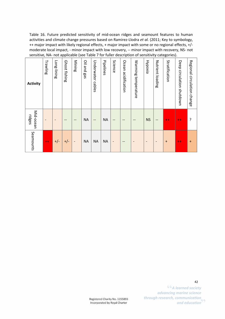
42
Table 16. Future predicted sensitivity of mid-ocean ridges and seamount features to human activities and climate change pressures based on Ramirez-Llodra et al. (2011; Key to symbology, ++ major impact with likely regional effects, + major impact with some or no regional effects, +/- moderate local impact, - minor impact with low recovery, -- minor impact with recovery, NS- not sensitive, NA- not applicable (see Table 7 for fuller description of sensitivity categories).
Activity
Trawlin
g
Lon
g-linin
g
Gh
ost fish
ing
Min
ing
Oil an
d gas
Un
derw
ater cables
Pip
elines
Science
Oce
an acid
ification
Warm
ing tem
peratu
re
Hyp
oxia
Nu
trient lo
adin
g
Stratification
Dee
p circu
lation
shu
tdo
wn
Regio
nal circu
lation
chan
ge
Mid
-ocean
rid
ges
- - -- -- NA -- NA -- -- -- NS -- ++ ++ ?
Seamo
un
ts
++ +/- +/- - NA NA NA - -- - - - + ++ +

43
Case study 4. Hydrothermal vents.
CS 4.1 Description and evidence of hydrothermal vents in Ascension Island
Evidence was found that four hydrothermal vents are present within Ascension Island’s EEZ; a fifth was found outside the zone to the north of the Island (Fig. 5). The Nibelungen field hosts an active black smoker (“Drachenschlund”) in vicinity of several extinct chimneys (Melchert et al., 2008). Its particular tectonic setting indicated that it represented a new form of hydrothermal system, which lies outside of the axial valley of the Mid-Atlantic Ridge (Melchert et al. 2008). Two further vents were identified by their plume in the fields SMAR1 & 2 (Devey et al., 2005). The southernmost hydrothermal field called Lilliput, consists of four small and diffuse vent sites (Haase et al., 2009). The fauna around the vents displays small/juvenile mussels with low growth rates, probably indicating that thermal activity occurs in pulses (Haase et al., 2009). For habitat classifications see Table 17). Endemism rates in hydrothermal vents can be high, especially at active vents where species rely on the venting fluids. Such communities consist primarily of chemosynthetic microbes, which use chemical energy as food supply (Van Dover et al., 2018). Black smokers in these ecosystems discharge metal-rich fluids, and these metals precipitate at or below the seabed to form polymetallic (especially copper and zinc) sulphides. As a result, these materials are of interest for the growing deep-sea mining industry (Van Dover et al., 2018).
Figure 4. Location of hydrothermal vents in Ascension Island’s EEZ (circle). Note an additional hydrothermal vent (Tannenbaum) just outside the EEZ (Source: AIGCFD).

44
Table 17. Hydrothermal vents are included in the EUNIS habitat classification under level A6.9 Vents, seeps, hypoxic and anoxic habitats of the deep-sea.
EUNIS code 2007 EUNIS level EUNIS name 2007
A6.9 3 Vents, seeps, hypoxic and anoxic habitats of the deep-sea
A6.91 4 Deep-sea reducing habitats
A6.913 5 Cetacean and other carcasses on the deep-sea bed
A6.94 4 Vents in the deep-sea
Hydrothermal vents could potentially provide the following services:
Supporting services: Primary production Larval/gamete supply Nutrient cycling Formation of species habitat Formation of physical barriers Formation of seascape Regulating Services: Regulation of water and sediment quality Carbon sequestration Climate regulation Clean water and sediment
Provisioning services: Genetic resources
Cultural services: Education Aesthetic benefits Tourism and nature watching
CS 4.1.1 Supporting services
There is evidence for ecosystem services linked with the biological community living in and around hydrothermal vents (Thurber et al., 2014). Hydrothermal vents host unique high-density faunal communities with high levels of endemism that appear to increase with increasing depth (Thurbe, et al., 2014). Primary production is an important ecosystem service provided by chemosynthetic organisms that are found living in and around vents as well as explosive mud volcanoes and cold seeps. These organisms contribute to the marine oxidation of methane, which reduces geological and biological methane release, promoting carbonate precipitation and habitat formation (Thurber et al., 2014). There is evidence that active hydrothermal vents host invertebrate populations with local larval supply and retention during periods of habitat stability (Van Dover et al., 2014).
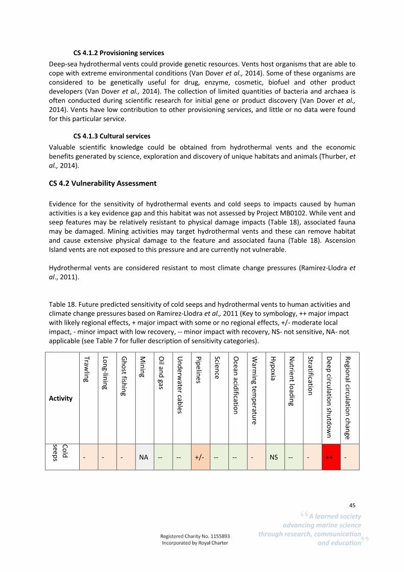
45
CS 4.1.2 Provisioning services
Deep-sea hydrothermal vents could provide genetic resources. Vents host organisms that are able to cope with extreme environmental conditions (Van Dover et al., 2014). Some of these organisms are considered to be genetically useful for drug, enzyme, cosmetic, biofuel and other product developers (Van Dover et al., 2014). The collection of limited quantities of bacteria and archaea is often conducted during scientific research for initial gene or product discovery (Van Dover et al., 2014). Vents have low contribution to other provisioning services, and little or no data were found for this particular service.
CS 4.1.3 Cultural services
Valuable scientific knowledge could be obtained from hydrothermal vents and the economic benefits generated by science, exploration and discovery of unique habitats and animals (Thurber, et al., 2014).
CS 4.2 Vulnerability Assessment
Evidence for the sensitivity of hydrothermal events and cold seeps to impacts caused by human activities is a key evidence gap and this habitat was not assessed by Project MB0102. While vent and seep features may be relatively resistant to physical damage impacts (Table 18), associated fauna may be damaged. Mining activities may target hydrothermal vents and these can remove habitat and cause extensive physical damage to the feature and associated fauna (Table 18). Ascension Island vents are not exposed to this pressure and are currently not vulnerable. Hydrothermal vents are considered resistant to most climate change pressures (Ramirez-Llodra et al., 2011). Table 18. Future predicted sensitivity of cold seeps and hydrothermal vents to human activities and climate change pressures based on Ramirez-Llodra et al., 2011 (Key to symbology, ++ major impact with likely regional effects, + major impact with some or no regional effects, +/- moderate local impact, - minor impact with low recovery, -- minor impact with recovery, NS- not sensitive, NA- not applicable (see Table 7 for fuller description of sensitivity categories).
Activity
Trawlin
g
Lon
g-linin
g
Gh
ost fish
ing
Min
ing
Oil an
d gas
Un
derw
ater cables
Pip
elines
Science
Oce
an acid
ification
Warm
ing tem
peratu
re
Hyp
oxia
Nu
trient lo
adin
g
Stratification
Dee
p circu
lation
shu
tdo
wn
Regio
nal circu
lation
chan
ge
Co
ld
seep
s - - - NA -- -- +/- -- -- - NS -- - ++ -

46
Hyd
roth
ermal
vents
NA NA NA ++ NA NA NA -- NA NA NA NS - ++ --
CS 4.3 Summary
Within Ascension Island’s EEZ, there is evidence for the presence of hydrothermal vents. Seeps and other anoxic habitats of the deep-sea are likely to be present. Hydrothermal vents could contribute to several human benefits. There is evidence that the biological communities that live around hydrothermal vents are necessary for supporting complex, biogenic habitat formations. From the literature review, it is evident that high biodiversity is generally a positive aspect for the ecological functioning of habitats and this is likely to be applicable to hydrothermal vents and seeps. Currently vents in Ascension Island’s EEZ are not vulnerable to human activities.

47
Case Study 5. Intertidal habitats.
CS 5.1 Description and evidence for presence in Ascension Island
The absence of lagoons and sheltered bays means that the entire intertidal and shallow subtidal area around Ascension Island is subject to high levels of wave action. Typical coastal habitats, such as coral reefs, mangroves and seagrass beds are absent; the mapped intertidal and shallow subtidal habitats around Ascension Island comprise volcanic rocky substrate and a few beaches with coarse sand (see Fig. 6). Barnes et al. (2015) described how much of the habitat on Ascension Island is formed from lava flows, which fragmented to form ridges and slopes. The intertidal and infralittoral fringe remain largely bare, although cryptic species are found under boulders and in crevices where they are sheltered from wave action and predation, although crushing associated with boulder movements is common (Barnes, 2017). Where rock ridges create deep inlets, the protection from swells allows common rock oysters (Saccostrea cucullata) to establish (Arkhipkin et al., 2017). Grazing by Ascension blackfish (Melichthys niger) restricts algal growth in the shallow subtidal area to grazing resistant encrusting coralline algae (Lithothamnia spp) and rhodoliths (Price and John, 1980). The calcareous seaweeds cover large surfaces and dominate the underwater seascape (Tsiamis et al., 2017). They provide either reef-forming structures or loose piles on the seabed. Where grazing is restricted in niches and crevices, more diverse algal communities can be present (Tsiamis et al., 2017). Ascension Island contains two clusters of anchialine pools, inland of Shelley Beach, that are connected to the sea through subterranean fissures (see AIG, 2015a). The ‘marl pool’ series, consists of 3-4 pools, the largest of which measures approximately 6 m in major diameter. The ‘coral pool’ series lies 125 m to the south east of the marl ponds and is comprised of around 10 pools ranging in size from 7 m diameter to less than a metre (AIG, 2015). The pools differ in substratum type: marl pools have a bottom of deep, soft, sedimentary material, whereas coral pools have predominantly rocky substrates and are often lined with fragments of the coral Favia gravida. The pools are home to endemic species including shrimp (Typhlatya rogersi and Procaris ascensionis) and amphipods (Melita spp., Maera spp. And Elasmopus spp.).
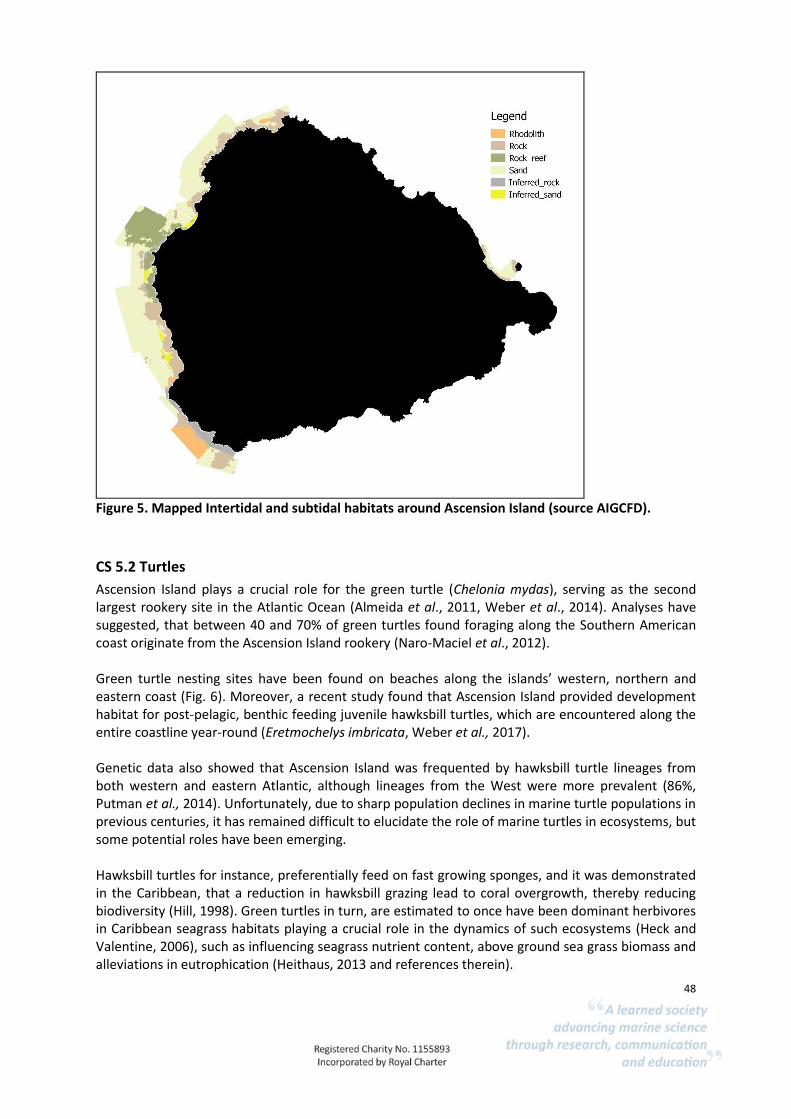
48
CS 5.2 Turtles
Ascension Island plays a crucial role for the green turtle (Chelonia mydas), serving as the second largest rookery site in the Atlantic Ocean (Almeida et al., 2011, Weber et al., 2014). Analyses have suggested, that between 40 and 70% of green turtles found foraging along the Southern American coast originate from the Ascension Island rookery (Naro-Maciel et al., 2012). Green turtle nesting sites have been found on beaches along the islands’ western, northern and eastern coast (Fig. 6). Moreover, a recent study found that Ascension Island provided development habitat for post-pelagic, benthic feeding juvenile hawksbill turtles, which are encountered along the entire coastline year-round (Eretmochelys imbricata, Weber et al., 2017). Genetic data also showed that Ascension Island was frequented by hawksbill turtle lineages from both western and eastern Atlantic, although lineages from the West were more prevalent (86%, Putman et al., 2014). Unfortunately, due to sharp population declines in marine turtle populations in previous centuries, it has remained difficult to elucidate the role of marine turtles in ecosystems, but some potential roles have been emerging. Hawksbill turtles for instance, preferentially feed on fast growing sponges, and it was demonstrated in the Caribbean, that a reduction in hawksbill grazing lead to coral overgrowth, thereby reducing biodiversity (Hill, 1998). Green turtles in turn, are estimated to once have been dominant herbivores in Caribbean seagrass habitats playing a crucial role in the dynamics of such ecosystems (Heck and Valentine, 2006), such as influencing seagrass nutrient content, above ground sea grass biomass and alleviations in eutrophication (Heithaus, 2013 and references therein).
Figure 5. Mapped Intertidal and subtidal habitats around Ascension Island (source AIGCFD).
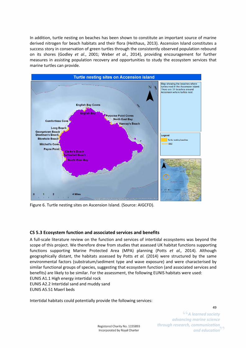
49
In addition, turtle nesting on beaches has been shown to constitute an important source of marine derived nitrogen for beach habitats and their flora (Heithaus, 2013). Ascension Island constitutes a success story in conservation of green turtles through the consistently observed population rebound on its shores (Godley et al., 2001; Weber et al., 2014), providing encouragement for further measures in assisting population recovery and opportunities to study the ecosystem services that marine turtles can provide.
Figure 6. Turtle nesting sites on Ascension Island. (Source: AIGCFD).
CS 5.3 Ecosystem function and associated services and benefits
A full-scale literature review on the function and services of intertidal ecosystems was beyond the scope of this project. We therefore drew from studies that assessed UK habitat functions supporting functions supporting Marine Protected Area (MPA) planning (Potts et al., 2014). Although geographically distant, the habitats assessed by Potts et al. (2014) were structured by the same environmental factors (substratum/sediment type and wave exposure) and were characterised by similar functional groups of species, suggesting that ecosystem function (and associated services and benefits) are likely to be similar. For the assessment, the following EUNIS habitats were used: EUNIS A1.1 High energy intertidal rock EUNIS A2.2 Intertidal sand and muddy sand EUNIS A5.51 Maerl beds Intertidal habitats could potentially provide the following services:
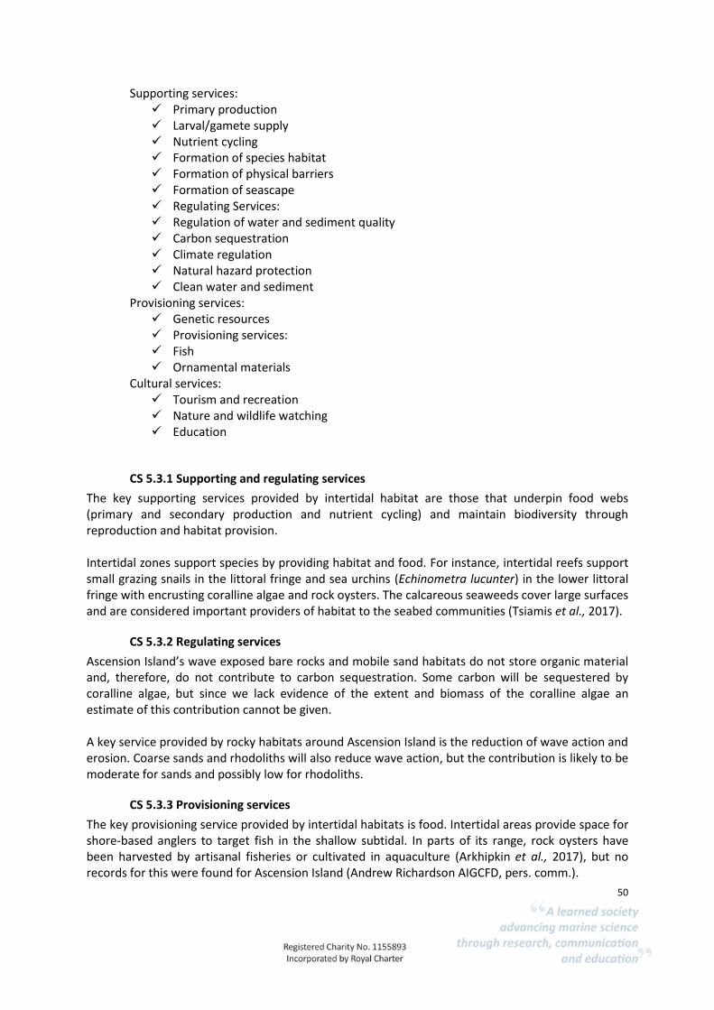
50
Supporting services: Primary production Larval/gamete supply Nutrient cycling Formation of species habitat Formation of physical barriers Formation of seascape Regulating Services: Regulation of water and sediment quality Carbon sequestration Climate regulation Natural hazard protection Clean water and sediment
Provisioning services: Genetic resources Provisioning services: Fish Ornamental materials
Cultural services: Tourism and recreation Nature and wildlife watching Education
CS 5.3.1 Supporting and regulating services
The key supporting services provided by intertidal habitat are those that underpin food webs (primary and secondary production and nutrient cycling) and maintain biodiversity through reproduction and habitat provision. Intertidal zones support species by providing habitat and food. For instance, intertidal reefs support small grazing snails in the littoral fringe and sea urchins (Echinometra lucunter) in the lower littoral fringe with encrusting coralline algae and rock oysters. The calcareous seaweeds cover large surfaces and are considered important providers of habitat to the seabed communities (Tsiamis et al., 2017).
CS 5.3.2 Regulating services
Ascension Island’s wave exposed bare rocks and mobile sand habitats do not store organic material and, therefore, do not contribute to carbon sequestration. Some carbon will be sequestered by coralline algae, but since we lack evidence of the extent and biomass of the coralline algae an estimate of this contribution cannot be given. A key service provided by rocky habitats around Ascension Island is the reduction of wave action and erosion. Coarse sands and rhodoliths will also reduce wave action, but the contribution is likely to be moderate for sands and possibly low for rhodoliths.
CS 5.3.3 Provisioning services
The key provisioning service provided by intertidal habitats is food. Intertidal areas provide space for shore-based anglers to target fish in the shallow subtidal. In parts of its range, rock oysters have been harvested by artisanal fisheries or cultivated in aquaculture (Arkhipkin et al., 2017), but no records for this were found for Ascension Island (Andrew Richardson AIGCFD, pers. comm.).

51
In the UK, rhodoliths are used as a fertiliser and soil conditioner, but it is not clear if they have ever been extracted for this purpose in Ascension Island.
CS 5.3.4 Cultural services
Intertidal habitats provide a range of cultural services including opportunities for tourism, nature watching and education, including less tangible value such as aesthetic benefits and spiritual and cultural well-being (Potts et al., 2014). The intertidal habitats on Ascension Island currently deliver a range of cultural services. The beaches provide space for a range of recreational activities, such as shore fishing, which is particularly popular. Conservation and management of intertidal habitats provides volunteering and work opportunities through surveying, monitoring work, scientific surveys and other associated activities. Ascension’s intertidal habitats are considered to be able to support further cultural service development around education, scientific research and tourism. The presence of turtle nesting beaches offers the opportunity to develop scientific research, education and tourism programmes further. Cultural services through education and scientific research are important but could be developed further. For example, volcanic habitats already provide a key attraction for geologists and tours for interested groups, but there is an opportunity to develop specialised tourism. The Biodiversity Action Plan for achihaline pools suggests that the high biodiversity value of this habitat combined with its small area, low species diversity and simplistic food web may make it a useful microcosm for monitoring and predicting the impacts of climate change on marine ecosystems (AIG, 2015a)
CS 5.4 Vulnerability Assessment
The sensitivity of intertidal habitats has been systematically assessed using the MarESA approach by MarLIN. The habitat sensitivities for coarse sands and wave exposed rocky shores were considered applicable to Ascension Island habitats as these habitats are dominated by physical factors (high levels of wave action) rather than biological interactions. The sensitivity of tide pools assessed by MarLIN was also considered applicable, as these contain similar functional groups of algae and grazers (snails and urchins). As these functional groups share similar life history characteristics (attachment and mobility, morphology and feeding type) sensitivities are likely to be applicable between similar intertidal habitats in the UK and Ascension Island. Although extant to this assessment, it is important to note that ground-fish, such as rockhind/grouper and moray eel, in the shallow intertidal areas are vulnerable to over-fishing by recreational anglers. Climate change pressures are likely to impact Ascension Island habitats but the level of effect is not uncertain. Sea level at Ascension Island is estimated to have risen by 7 cm since 1955 (Woodworth et al., 2012) and this trend is projected to accelerate during the first half of the 21st century (IPCC, 2013).
CS 5.4.1 Sensitivity of wave exposed habitats
In general, the wave exposed habitats are species poor and exposed to high levels of grazing, wave action, boulder movement and crushing (Barnes, 2017). Rock oysters live longer (14-16 years) and
52
growth is slower in Ascension than other parts of the range (Arkhipkin et al., 2017). As previously mentioned, there is no evidence that oysters have ever been harvested at Ascension. If this practice began, populations are likely to be vulnerable to indiscriminate over collection across juvenile and adult size classes. The small size of Ascension Island could mean that over-collecting could reduce the supply of larvae to support recolonization, if all habitats were over-harvested, inhibiting recovery.
CS 5.4.2 Vulnerability of coarse sands including turtle nesting areas
A key threat to coarse sands on Ascension Island is encroachment by invasive, salt-tolerant plants, including Prosopis juliflora, Nicotiana glauca, Argemone mexicana, Heliotropium curassavicum, Waltheria indica and Chenopodiastrum murale. The tree Casuarina equisetifolia is also rapidly expanding its range in the east of the Island and is an aggressive invader of sand beaches (AIG, 2015b). Where these colonise turtle nesting beaches they can reduce the extent of suitable nesting habitat. Invasion by non-natives can result in the loss of coarse sand habitat where the invasive plants stabilise sediments and trap organic matter resulting in soil formation. Previous mining of beach sand for construction has resulted in a significant and lasting reduction in the extent of suitable nesting habitat for turtles (AIG, 2015b). The practice has been subject to an unofficial moratorium since the mid-1990s, although permission to remove small volumes of sand has still occasionally been granted. An environmental impact assessment commissioned in 2004 suggested that 78% of nesting beaches were showing some evidence of erosion and recommended that no further sand extraction should be permitted (Cambers, 2004).
CS 5.4.3 Sensitivity of rhodoliths.
Due to their slow growth rates rhodolith habitats have low recovery rates and the habitat is therefore, considered highly sensitive to activities that result in severe impacts on rhodoliths. Attached and free-living rhodoliths will be highly sensitive to targeted extraction. The rhodoliths themselves are relatively tough but may be fragmented by abrasion and dredging, resulting in reduced habitat complexity. This could reduce the value of the habitat as a refugia, spawning or nursery area for other species. Rhodoliths are vulnerable to human activities that reduce water quality and water clarity resulting from land and coastal development, placement of artificial structures and pressures such as sedimentation and nutrient enrichment resulting from sewage disposal and agricultural run-off (Nelson, 2009). Climate change pressures are likely to impact on rhodoliths but the magnitude of impacts and timescale is uncertain (Nelson, 2009). Calcareous seaweeds are highly vulnerable to ocean acidification (Koch et al., 2013), increasing dissolved CO2 levels may reduce growth rates and could result in the loss of this habitat.
CS 5.4.4 Sensitivity of Anchialine pools
Climate change constitutes the only significant long-term threat to Ascension Island’s unique anchialine pool habitats, but the magnitude of the threat and the likely outcomes are difficult to predict at present (AIG, 2015a). Invasive aquatic species could alter the biodiversity of these pools and reduce suitability for endemic species.

53
CS 5.5 Summary
The key services provided by intertidal habitats are the provision of food and habitat for other species, particularly turtles. Intertidal areas and the shallow subtidal support shore fishing for recreation and food. Development of specialist tourism focussed on natural habitats, sportfishing and research and conservation activities offer opportunities to benefit from the island’s natural habitats. Currently there are few anthropogenic impacts. Climate change pressures that cannot be managed locally, such as increased temperatures may exceed species tolerances and increased sea levels are likely to result in impacts by reducing shoreline extents (coastal squeeze). Ocean acidification could severely impact rhodolith habitats by reducing growth and may result in the loss of this habitat. The decline or loss of these important components of the ecosystem could have wide-reaching consequences for the shallow marine ecosystem but the level of vulnerability to climate chance and ocean acidification is uncertain. Non-native species may alter habitats and result in the reversion of one habitat type to another resulting in changes in biological assemblages and the services delivered. Sandy beaches on Ascension Island are noted as being particularly vulnerable to non-natives that encroach on beaches and result in changes in habitat. Invasion could have a strong impact on turtle nesting sites.
Chapter 5 Key evidence gaps, limitations and conclusions
5.1 Key evidence gaps and limitations
Key evidence gaps for this project are the lack of evidence for the presence and extent of deep-sea habitats and associated biological assemblages. Technological innovations are allowing more research to be carried out in deep-sea habitats but current understanding of the ecological functions (supporting services) of deep-sea habitats and species and the contribution to final ecosystem services is limited. This represents a key limitation of this study. Research in the deep-sea is subject to obvious logistical constraints and our understanding of key facets of deep-sea habitats is limited compared to terrestrial and coastal ecosystems. Little evidence is available to assess ecological function, species population dynamics and the sensitivity of deep-sea habitats to human activities. The lack of detailed information on the species present and the general lack of information on the life histories and habitat dependencies of deep-sea benthic invertebrates and bottom dwelling fishes and other associated species, results in a high degree of uncertainty for assessing sensitivity. The review of ecosystem services highlighted the importance of species diversity in delivering ecosystem services. The sensitivity assessments were based on previous assessments, which were developed using expert judgement-based approaches. Such approaches have limited audit trails associated with the decisions made in assigning sensitivity. Very little evidence is available to assess the sensitivity of deep-sea habitats to most pressures, including environmental changes resulting from anthropogenic climate change, litter and pollution.

54
The lack of available sensitivity assessments for deep-sea habitats reflects the generally low level of understanding and research on deep-sea habitats. Compared to shelf habitats, the deep-sea is less accessible and costlier. As technologies to access deep-sea habitats, such as Remotely Operated Vehicles (ROVs) and Autonomous Underwater Vehicles (AUVs) improve, the data available to understand the biological communities present in deep-sea habitats and to identify evidence for impacts is likely to increase. However, ecological studies on life-history traits, habitat and population connectedness and recovery rates are likely to remain key information gaps to assess sensitivity (as they do in coastal habitats and shelf seas).
5.2 Conclusions
5.2.1 Habitat presence and extent
In summary, confidence in the presence of the following deep-sea features is high: bedrock, mixed substrata, deep-sea sand and communities of deep-sea corals, as well as seamounts, oceanic ridges and hydrothermal vents. Based on expert knowledge: deep-sea mud and associated communities, seeps in the deep-seabed, gas hydrates and carcasses of large pelagic animals on the deep-seabed are present. As Ascension Island has a narrow shelf and lacks human infrastructure, such as oil and gas wells, it was considered that deep-sea artificial hard substrata and deep-sea features associated with continental shelves such as deep-sea channels, slope failures and slumps on the continental slope were likely to be absent. Manganese nodules were judged unlikely to be present as conditions are unsuitable for formation. Confidence in the presence or absence of communities of allochthonous material was low. Confidence in the spatial extent for all deep-sea features is low with the exception of ocean ridges and seamounts which are mapped geomorphological features.
5.2.3 Ecosystem service delivery
All the present habitats support the formation of species habitats, which is important to support the physical properties of the habitats necessary for the survival of species. All habitats were considered to contribute to most of the assessed supporting services. Final services were poorly documented, and expert opinion suggested that no benthic habitats were considered to contribute to the water cycling service or algae and seaweed or ornamental materials. Cultural services are associated with deep-sea habitats through the potential to support research and education and public engagement activities. Cultural services are currently underutilised, Ascension Island ecosystems offer opportunities to develop high-value cultural services around scientific research and education and tourism focussed around sport fishing, scuba diving and nature and wildlife watching. Management of these activities to prevent impacts such as disturbance of turtles and nests, boat disturbance to cetaceans as well as limiting catches of sharks and other large fish can ensure these activities are carried out in a sustainable manner to support long-term benefits.
55
5.2.4 Vulnerability assessments- key findings
The vulnerability assessment identified that deep-sea benthic habitats are sensitive to physical damage and climate change pressures. Currently no human activities are causing physical damage but any future proposals to introduce damaging activities should be risk-assessed. Climate change cannot be directly managed and is a key threat to which deep-sea habitats around Ascension Island are vulnerable to. Based on the evidence and sources outlined in this project, deep-sea habitats around Ascension Island are considered to have low vulnerability to pressures resulting from human activities due to current low levels of exposure. The most widespread and damaging human pressure exerted on deep-sea habitats globally is physical damage caused by fishing gear that comes into contact with the seabed. Habitats characterised by fragile, erect species with long recovery rates, such as reefs of deep-sea sponges and the coral L. pertusa are highly sensitive to this pressure. As deep-sea trawls are not used around Ascension Island none of the deep-sea habitats are vulnerable to this pressure. Any activities which were to take place that result in abrasion, penetration and damage to the substratum, extraction or physical change should be subject to impact assessments. Damage to vulnerable, slow recovering species such as L. pertusa and other reef forming species such as deep-sea sponges should be avoided. Intertidal sandy beaches are threatened by the establishment of non-native species that could result in physical change and loss of the habitat. Non-native species have not been identified as a present threat to subtidal and deep-sea habitats but this situation could of course change depending on accidental or deliberate introductions. Marine invasive species may be transported by shipping, either in ballast water or as fouling organisms, however, these vectors transport attached fouling species are more likely to transport organisms suited to life in upper sea surface layers, or intertidal and shallow subtidal species, rather than deep-sea species. Climate change may already be impacting deep-sea ecosystems around Ascension Island and future effects and consequences are a key evidence gap. Deep-sea ecosystems have been identified as likely to be severely impacted by changes in temperature Ramirez-Llodra et al., 2011) and pH. Of particular concern are cold-water coral reefs, this is likely to be an extensive habitat around Ascension Island and contribute significantly to ecosystem services such as habitat provision and possibly provisioning services.

56
References
Almeida, A. de P., Moreira, L.M.P., Bruno, S.C., Thomé, J.C.A., Martins, A.S., Bolten, A.B., Bjorndal, K.A., 2011. Green turtle nesting on trindade island, Brazil: Abundance, trends, and biometrics. Endanger. Species Res. 14, 193–201. https://doi.org/10.3354/esr00357
Althaus, F., Williams, A., Schlacher, T., Kloser, R., Green, M., Barker, B., Bax, N., Brodie, P. & Schlacher-Hoenlinger, M., 2009. Impacts of bottom trawling on deep-coral ecosystems of seamounts are long-lasting. Marine Ecology Progress Series, 397, 279-294.
Amado-Filho, G.M., Moura, R.L., Bastos, A.C., Salgado, L.T., Sumida, P.Y., Guth, A.Z., Francini-Filho, R.B., Pereira-Filho, G.H., Abrantes, D.P., Brasileiro, P.S. and Bahia, R.G., (2012) Rhodolith beds are major CaCO3 bio-factories in the tropical South West Atlantic. PloS one, 7(4), p. e35171.
Arkhipkin, A., Boucher, E., Gras, M. and Brickle, P., 2017. Variability in age and growth of common rock oyster Saccostrea cucullata (Bivalvia) in Ascension Island (central-east Atlantic). Journal of the Marine Biological Association of the United Kingdom, 97(4), pp.735-742.
Armstrong, C.W., Foley, N. S., Tinch, R., van den Hove, S. (2012) Services from the deep: Steps towards valuation of deep-sea goods and services, Ecosystem Services, 2-13.
Ascension Island Government (2015a) Anchialine pool habitat action plan. In: The Ascension Island Biodiversity Action Plan. Ascension Island Government Conservation Department, Georgetown, Ascension Island.
Ascension Island Government (2015b) Green turtle species action plan. In: The Ascension Island Biodiversity Action Plan. Ascension Island Government Conservation Department, Georgetown, Ascension Island.
Awale D & Phillott AD (2014) A review of the adverse effects of Casuarina spp. on coastal ecosystems and sea turtle nesting beaches. Indian Ocean Turtle Newsletter 19, 15–19.
Barnes, D.K.A. (2017). Marine colonization and biodiversity at Ascension Island and remote islands. J. Mar. Biol. Assoc. United Kingdom 97, 771–782.
Barnes, D.K.A., Brown, J., Brickle, P., Downes, K., Enderlein, P., Gowland, E., Hogg, O.T., Laptikhovsky, V., Morley, S., Nolan, E., Richardson, A., Sands, C.J., Weber, N and Weber, S. (2015). Marine biodiversity of Ascension Island’s shelf; scientific support for a marine protected area. Unpublished JR15003 cruise report, British Antarctic Survey.
Bourne, P., Simmons, L. (2001). The distribution an breeding success of seabirds on and around ascension in the Tropical Atlantic Ocean. Atl. Seabirds 3, 187–202.
Bourque JR, Demopoulos AWJ. (2018) The influence of different deep-sea coral habitats on sediment macrofaunal community structure and function. PeerJ6: e5276.
Bracken, Matthew E.S., Bracken, B. E, Rogers-Bennett, L. (2007) Species diversity and foundation species: Potential indicators of fisheries yields and marine ecosystem functioning. Biodiversity, foundation species, and marine ecosystem management, vol. 48, pp. 1-10.
57
Brewin, P.E., Brown, J., Brickle, P. (2016). Diurnal variation of fish and macrobenthic invertebrate community structure in an isolated oceanic island of the South Atlantic. J. Mar. Biol. Assoc. United Kingdom 96, 737–747.
Brooke, S. and Järnegren, J., 2013. Reproductive periodicity of the scleractinian coral Lophelia pertusa from the Trondheim Fjord, Norway. Marine biology, 160(1), pp.139-153.
Buhl-Mortensen, L., Vanreusel, A., Gooday, A. J., Levin, L. A., Priede, I. G., Buhl-Mortenser, P., Gheerardyn, H., King, N. J., and Raes, M. (2010) biological structures as a source of habitat heterogeneity and biodiversity on the deep ocean margins, Marine Ecology, vol. 31, pp. 21-50.
Cambers G (2004) Environmental Impact Assessment: Beach sand extraction on Ascension Island, South Atlantic. University of Puerto Rico.
Clark, M. R., Rowden, A. A., Schlacher, T., Williams, A., Consalvey, M., Stocks, K. I., Roger, A. D., O’Hara, T. D., White, M., Shank, T. and Hall-Spencer, J.M. (2009) The ecology of seamounts: structure, function, and human impacts. Annual Review of Marine Science, vol. 2, pp. 253-278.
Collins, A.M., Coughlin, D., Miller, J., Kirk, S. 2015. The Production of Quick Scoping Reviews and Rapid Evidence Assessments: A How to Guide.
Costello, M. J., McCrea, M., Freiwald, A., Lundalv, T., Jonsson, L., Bett, B., van Weering, T. C., de Haas, H., Murray Robets, J., Allen, D., (2005) Role of cold-water Lophelia pertusa coral reeds as fish habitat in the NE Atlantic. Springer-Verlag Berlin Heidelberg, pp 771-805
Danovaro, R., Gambi, C., Dell’Anno, A., Corinaldesi, C., Fraschetti, S., Vanreusel, A., Vincx, M. and Gooday, A.J. (2008) Exponential decline of deep-sea ecosystem functioning linked to benthic biodiversity loss, Corrent Biology, vol. 18, 1-8.
Defra, 2004. Review of Marine Nature Conservation. Working Group report to Government. Department for Environment, Food and Rural Affairs, London, 160 pp.
Devey, C.W., Lackschewitz, K.S., Baker, E. (2005). Hydrothermal and Volcanic Activity Found on the Southern Mid-Atlantic Ridge. Eos (Washington. DC). 86, 209–216.
Edwards, A.J. (1993). New records of fishes from the bonaparte seamount and saint helena island, south atlantic. J. Nat. Hist. 27, 493–503.
Faneros, G. and Arnold, F. (2003) Geomorphology of two seamounts offshore Ascension Island, South Atlantic Ocean, Report by GeoSolutions (Pacific).
FAO, 2009. Report of the Technical Consultation on International Guidelines for the Management of Deep-sea Fisheries in the High Seas, Rome. 4–8 February and 25–29 August 2008, FAO Fisheries and Aquaculture Report, 881. 86 pp.
Fletcher, S., Saunders, J., and Herbert, R.J.H (2011) A review of the ecosystem services provided by broad-scale marine habitats in England’s MPA network, Journal of Coastal Research, pp. 378-383.
Fosså, J.H., Mortensen, P.B. and Furevik, D.M., 2002. The deep-water coral Lophelia pertusa in Norwegian waters: distribution and fishery impacts. Hydrobiologia, 471(1-3), pp.1-12.

58
German, C., Petersen, S. and Hannington, M. D. (2016) Hydrothermal exploration of mid-ocean ridges: where might the largest sulphide deposits be forming? Report. Pp. 1-33.
Godley, B.J., Broderick, a. C., Hays, G.C., 2001. Nesting of green turtles (Chelonia mydas) at Ascension Island, South Atlantic. Biol. Conserv. 97, 151–158.
Grehan, A., Long, R., Deegan, B. and Ó Cinneide, M., 2003. The Irish Coral Task Force and Atlantic Coral Ecosystem Study: Report on Two Deep-Water Coral Conservation Stakeholder Workshops Held in Galway in 2000 and 2002.
Haase, K.M., Koschinsky, A., Petersen, S., Devey, C.W., German, C., Lackschewitz, K.S., Melchert, B., Seifert, R., Borowski, C., Giere, O., Paulick, H. (2009). Diking, young volcanism and diffuse hydrothermal activity on the southern Mid-Atlantic Ridge: The Lilliput field at 9°33′S. Mar. Geol. 266, 52–64.
Hall-Spencer, J., Allain, V., and Fossa, J.H. (2002) Trawling damage to Northeast Atlantic ancient coral reefs, the Royal Society, vol.269, pp. 507-511.
Hays, G.C., Adams, C.R., Broderick, A.C., Godley, B.J., Lucas, D.J., Metcalfe, J.D., Prior, A.A. (2000). The diving behaviour of green turtles at Ascension Island. Anim. Behav. 59, 577–586.
Heck, K.L., Valentine, J.F., 2006. Plant-herbivore interactions in seagrass meadows. J. Exp. Mar. Bio. Ecol. 330, 420–436.
Heithaus, M.R., 2013. Predators, Prey, and the Ecological Roles of Sea Turtles, in: Wyneken, J., Lohmann, K.J., Musick, J.A. (Eds.), The Biology of Sea Turtles, Volume III. CRC Press, Boca Raton, pp. 249–284.
Hill, M.S., 1998. Spongivory on Caribbean reefs releases corals from competition with sponges. Oecologia 117, 143–150.
Holt, T.J., Jones, D.R., Hawkins, S.J. & Hartnoll, R.G., 1995. The sensitivity of marine communities to man-induced change - a scoping report. Countryside Council for Wales, Bangor, CCW Contract Science Report, No. 65.
Hovland, M., Mortensen, P.B., Brattegard, T., Strass, P. and Rokengen, K., 1998. Ahermatypic coral banks off mid-Norway; evidence for a link with seepage of light hydrocarbons. Palaios, 13(2), pp.189-200.
Howell, K.L., Davies, J.S. and Narayanaswamy, B.E., 2010. A benthic classification system to aid in the implementation of marine protected area networks in the deep/high seas of the NE AtlanticIdentifying deep-sea megafaunal epibenthic assemblages for use in habitat mapping and marine protected area network design. Biological ConservationJournal of the Marine Biological Association of the United Kingdom, 90143(51), pp. 1041-105633-68.
IPCC (2013) Summary for Policymakers. In: Climate Change 2013: The Physical Science Basis. Contribution of Working Group I to the Fifth Assessment Report of the Intergovernmental Panel on Climate Change (eds. T. F. Stocker D. Qin G.-K. Plattner M. Tignor S. K. Allen J. Boschung A. Nauels Y. Xia V. Bex & P. M. Midgley). Cambridge University Press, Cambridge, UK. pp. 1–30.
Irving, R.A. (2015) The offshore marine environment of Ascension Island, South Atlantic: scientific review and conservation status assessment. Report to the Royal Society for the Protection of Birds (RSPB) by Sea-Scope Marine Environmental Consultants. 115 pp.

59
Jobstvogt, N., Hanley, n., Hynes, S., Kenter, J. and Witte, U. (2013) Twenty thousand sterling under the sea: Estimanting the value of protecting deep-sea biodiversity. Ecological Economics, pp. 10-19.
Koch, M., Bowes, G., Ross, C. and Zhang, X.H., (2013). Climate change and ocean acidification effects on seagrasses and marine macroalgae. Global change biology, 19(1), pp.103-132.
Koslow, J. A., Gowlett-Holmes, K., Lowry, J.K., O’Hara, T., Poore, G.C.B., Williams, A. (2001) Seamount benthic macrofauna off southern Tasmania: community structure and impacts of trawling, Marine Ecology Progress Series, vol. 213, pp. 111-125.
Kvile, K., Taranto, G. H., Pitcher, T. J., Morato, T. (2014) A global assessment of seamount ecosystems knowledge using an ecosystem evaluation framework, Biological Conservation, vol. 173, pp. 108-120.
Le, J. T., Levin, L. A., Carson, R.A. (2017) Incorporating ecosystem services into environmental management of deep-seabed mining, Deep-sea Research Part II: Topical Studies in Oceanography, vol.137, pp. 486-503.
Leduc, D., Rowden, A. A., Pilditch, C. A., Maas, E. W., & Probert, P. K. (2013). Is there a link between deep-sea biodiversity and ecosystem function? Marine Ecology, published online 17 April 2013.
Levin, L.A. and Sibuet, M. (2012) Understanding continental margin biodiversity: a new imperative, Annual Review of Marine Science, pp. 79-112.
Maier, C., (2008). High recovery potential of the cold-water coral Lophelia pertusa. Coral Reefs, 27(4), 821-821.
Melchert, B., Devey, C.W., German, C.R., Lackschewitz, K.S., Seifert, R., Walter, M., Mertens, C., Yoerger, D.R., Baker, E.T., Paulick, H., Nakamura, K. (2008). First evidence for high-temperature off-axis venting of deep crustal/mantle heat: The Nibelungen hydrothermal field, southern Mid-Atlantic Ridge. Earth Planet. Sci. Lett. 275, 61–69.
Mikkelson, N., Erlenkeuser, H., Killingley, J.S. and Berger, W.H., (1982). Norwegian corals: radiocarbon and stable isotopes in Lophelia pertusa. Boreas, 11(2), pp.163-171.
Millennium Ecosystem Assessment, 2005. Ecosystems and Human Well-being: Synthesis. Island Press, Washington, DC.
Morato, T., Bulman, C., Pitcher, T. J. (2009) Modelled effects of primary and secondary production enhancement by seamounts on local fish stocks. Deep-sea Research II, vol. 56, pp. 2713-2719.
Naro-Maciel, E., Bondioli, A.C.V., Martin, M., Almeida, A. de P., Baptistotte, C., Bellini, C., Marcovaldi, M.Â., Santos, A.J.B., Amato, G., (2012). The Interplay of Homing and Dispersal in Green Turtles: A Focus on the Southwestern Atlantic. J. Hered. 103, 792–805.
Nelson, W.A., (2009). Calcified macroalgae–critical to coastal ecosystems and vulnerable to change: a review. Marine and Freshwater Research, 60(8), pp.787-801.

60
Nolan, E. T., Barnes, D. K. A., Brown, J., Downes, K., Enderlein, P., Gowland, E., Hogg, O. T., Laptikhovsky, V., Morley, S. A., Mrowicki, R. J., Richardson, A., Sands, C. J., Weber, N., Weber, S. and Brickle, P. (2017) “Biological and physical characterization of the seabed surrounding Ascension Island from 100–1000 m,” Journal of the Marine Biological Association of the United Kingdom. Cambridge University Press, 97(4), pp. 647–659.
Pereira-Filho, G. H., Amado-Filho, G.M., de Moura, R.L., Bastos, A.C., Guimaraes, S.M.P.B., Salgado, L.T., Francini-Filho, R.B., Bahia, R.G., Abrantes, D.P., Guth, A.Z., and Brasileiro, P.S. (2012) Extensive rhodolith beds cover the summits of Southwestern Atlantic Ocean Seamounts, Journal of Coastal Research, vol. 28 (1), pp. 261-269.
Potts, T., Burdon, D., Jackson, E., Atkins, J., Saunders, J., Hastings, E. and Langmead, O., (2014). Do marine protected areas deliver flows of ecosystem services to support human welfare? Marine Policy, 44, pp.139-148.
Price and John, (1980). Ascension Island, south Atlantic: A survey of inshore benthic macroorganisms, communities and interactions. Aquatic Botany
Putman, N.F., Abreu-Grobois, F.A., Broderick, A.C., Ciofi, C., Formia, A., Godley, B.J., Stroud, S., Pelembe, T., Verley, P., Williams, N., (2014). Numerical dispersal simulations and genetics help explain the origin of hawksbill sea turtles in Ascension Island. J. Exp. Mar. Bio. Ecol. 450, 98–108.
Ramirez-Llodra, E., Brandt, A., Danovaro, R., De Mol. B., Escobar, E., German, C.R., Levin, L. A., Marinez Arbizu, P.,Menot, L., Buhl-Mortensen, P., Narayanaswamy, B.E., Smith, C. R., Tittensor, D.P., Tyler, P.A., Vanreusel, A. and Vecchione, M. (2010) Deep, diverse and definitely different: unique attributes of the world’s largest ecosystem. Biosciences (7), pp. 2851-2899.
Ramirez-Llodra, E., Tyler, P.A., Baker, M.C., Bergstad, O.A., Clark, M.R., Escobar, E., Levin, L.A., Menot, L., Rowden, A.A., Smith, C.R. and Van Dover, C.L., (2011). Man and the last great wilderness: human impact on the deep-sea. PLoS one, 6(8), p.e22588.
Roberts, D., Cummins, S., Davis, A. & Chapman, M., (2006). Structure and dynamics of sponge-dominated assemblages on exposed and sheltered temperate reefs. Marine Ecology Progress Series, 321, 19-30
Roberts, J.M. and Cairns, S.D., (2014). Cold-water corals in a changing ocean. Current Opinion in Environmental Sustainability, 7, pp.118-126.
Roberts, J.M., Wheeler, A., Freiwald, A., Cairns, S., (2009). Cold-Water Corals. Cambridge University Press, Cambridge, UK, 334 pp.
Robinson, L.A., Rogers, S. and Frid, C.L.J., (2008). A marine assessment and monitoring framework for application by UKMMAS and OSPAR–Assessment of Pressures and Impacts. Phase II: Application for regional assessments. Joint Nature Conservation Committee contract No. contract C-08-0007-0027, Lowestoft, UK.
Rogers, A. D., 2018. The Biology of Seamounts: 25 Years on, Advances in Marine Biology, https://doi.org/10.1016/bs.amb.2018.06.001

61
Ross, R.E. and Howell, K.L., (2013). Use of predictive habitat modelling to assess the distribution and extent of the current protection of ‘listed’deep‐sea habitats. Diversity and Distributions, 19(4), .433-445.
Sweetman, A.K., Thurber, A.R., Smith, C.R., Levin, L.A., Mora, C., Wei, C.L., Gooday, A.J., Jones, D.O., Rex, M., Yasuhara, M. and Ingels, J., (2017). Major impacts of climate change on deep-sea benthic ecosystems. Elementa: Science of the Anthropocene, 5, pp.Art-No.
Taranto GH, Kvile KØ, Pitcher TJ, Morato T (2012) An Ecosystem Evaluation Framework for Global Seamount Conservation and Management. PLoS ONE 7(8): e42950.
Thrush. S. F. and Dayton, P. K. (2002) Disturbance to marine benthic habitats by trawling and dredging: implications for marine biodiversity. Annual Review of Ecology and Systematics, vol. 33, pp. 449-473.
Thurber, A.R.; Sweetman, A.K.; Narayanaswamy, B.E.; Jones, D.O.B.; Ingels, J.; Hansman, R.L.. (2014) Ecosystem function and services provided by the deep-sea. Biogeosciences, 11 (14).
Tillin H.M., Hull S.C., Tyler-Walters H. 2010. Development of a sensitivity matrix (pressures-MCZ/MPA features). Report to the Department of Environment, Food and Rural Affairs from ABPmer, Southampton and the Marine Life Information Network (MarLIN) Plymouth: Marine Biological Association of the UK. Defra Contract No. MB0102 Task 3A, Report No. 22. SNH Objective Reference: A452466
Tsiamis, K., Peters, A.F., Shewring, D.M., Asensi, A.O., Van West, P. and Küpper, F.C., (2017). Marine benthic algal flora of Ascension Island, South Atlantic. Journal of the marine biological association of the United Kingdom, 97(4), pp.681-688.
Tyler-Walters, H., Hiscock, K., Lear, D.B. & Jackson, A., (2001). Identifying species and ecosystem sensitivities. Report to the Department for Environment, Food and Rural Affairs from the Marine Life Information Network (MarLIN), Marine Biological Association of the United Kingdom, Plymouth. Contract CW0826.
Van Dover, C. L, Arnaud-Haond, S., Gianni, M., Helmreich, S., Huber, J.A., Jaeckel, A.L., Metaxas, A., Pendleton, L.H., Petersen, S., Ramirez-Llodra, E., Steinberg, P.E., Tunnicliffe, V., Yamamoto, H. (2018) Scientific rationale and international obligations for protection of active hydrothermal vent ecosystems from deep-sea mining, Marine Policy, vol. 90, pp. 20-28.
Van Dover, C. L. (2014) Impacts of anthropogenic disturbances at deep-sea hydrothermal vent ecosystems: A review. Marine Environmental Research, vol. 102, pp. 59-72.
Wagner, H., Purser, A., Thomsen, L., Jesus, C.C. and Lundalv, T. (2011) Particulate organic matter fluxes and hydrodynamics at the Tisler cold-water coral reef, Journal of Marine Systems, vo. 85, pp.19-29.
Weber, S.B., Weber, N., Ellick, J., Avery, A., Frauenstein, R., Godley, B.J., Sim, J., Williams, N.,Broderick, A.C., (2014). Recovery of the South Atlantic’s largest green turtle nesting population. Biodivers. Conserv. 23, 3005–3018.

62
Weber, S.B., Weber, N., Godley, B.J., Pelembe, T., Stroud, S., Williams, N., Broderick, A.C., (2017). Ascension Island as a mid-Atlantic developmental habitat for juvenile hawksbill turtles. J. Mar. Biol. Assoc. United Kingdom 97, 813–820.
Weslawski, J. M., Snelgrove, P.V.R., Levin, L.A., Austen, M.C., Hawkins, S.J. and Whitlatch, R.B. (2004) Sustaining biodiversity and ecosystem services in soils and sediments, pp. 73-82.
White M, Wolff GA, Lundälv T, Guihen D, Kiriakoulakis K, Lavaleye M, Duineveld G (2012) Cold-water coral ecosystem (Tisler Reef, Norwegian Shelf) may be a hotspot for carbon cycling. Mar Ecol Prog Ser 465:11-23.
Wild, C., Mayr, C., Wehrmann, L., Schottner, S., Naumann, M., Hoffmann, F., Rapp, H. T. (2008) Organic matter release by cold water corals and its implication for fauna-microbe interaction, Marine Ecology Progress Series, vol. 372, pp. 67-75.
Wild, C., Wehrmann, L. M., Mayr, C., Schottner, S.I., Allers, E., Lundalv, T. (2009) Microbial degradation of cold-water coral-derived organic matter: potential implication for organic C cycling in the water column above Tisler Reef, Aquatic Biology, vol. 7, pp. 71-80. doi: 10.3354/ab00185.
Wirtz, P., Bingeman, J., Bingeman, J., Fricke, R., Hook, T. J. and Young, J. (2014) the fishes of Ascension Island, central Atlantic Ocean – new records and an annotated checklist, Journal of the Marine Biological Association of the United Kingdom, vol. 97 (4) pp. 783-798.
Wirtz, P., Bingeman, J., Bingeman, J., Fricke, R., Hook, T.J. and Young, J., (2017). The fishes of Ascension Island, central Atlantic Ocean–new records and an annotated checklist. Journal of the Marine Biological Association of the United Kingdom, 97(4), pp.783-798.
Woodworth, P.L., Foden, P.R., Jones, D.S., Pugh, J., Holgate, S.J., Hibbert, A., Blackman, D.L., Bellingham, C.R., Roussenov, V.M. and Williams, R.G., (2012). Sea level changes at Ascension Island in the last half century. African Journal of Marine Science, 34(3), pp.443-452.
Zeppilli, D., Pusceddu, A., Trincardi, F. and Danovaro, R. (2016) Seafloor heterogeneity influences the biodiversity-ecosystem functioning relationships in the deep-sea, Scientific Reports, pp. 1-12.
63
Annex 1. Habitat and species presence summary tables Table 19. Deep-sea habitat presence and extent.
EUNIS code 2007
EUNIS name 2007 Confidence in presence
Confidence in extent
Confidence in presence
A6.11 Deep-sea bedrock 3 1 3 Mapped, Peer-reviewed papers
A6.14 Boulders on the deep-sea bed
3 1 2 Grey literature or strong evidence of habitat presence (e.g. videos)
A6.2 Deep-sea mixed substrata
3 1 1 Obvious or Expertise knowledge
A6.22 Deep-sea biogenic gravels (shells, coral debris)
2 1
A6.3 Deep-sea sand 2 1 Confidence in extent
A6.61 Communities of deep-sea corals
3 1 3 Strong evidence of habitat extent
A6.611 Deep-sea [Lophelia pertusa] reefs
3 1 2 The habitat exists, but no strong evidence of the habitat extent
A6.7 Raised features of the deep-sea bed
3 1 1 Unknown
A6.71 Permanently submerged flanks of oceanic islands
3 1
A6.72 Seamounts, knolls and banks
3 3
A6.721 Summit communities of seamount, knoll or bank within euphotic zone
2 1
A6.722 Summit communities of seamount, knoll or bank within the mesopelagic zone, i.e. interacting with diurnally migrating plankton
1 1
A6.723 Deep summit communities of seamount, knoll or bank (i.e. below mesopelagic zone)
1 1
64
EUNIS code 2007
EUNIS name 2007 Confidence in presence
Confidence in extent
Confidence in presence
A6.724 Flanks of seamount, knoll or bank
3 1
A6.725 Base of seamount, knoll or bank
3 1
A6.7251 Moat around base of seamount, knoll or bank
1 3
A6.73 Oceanic ridges 3 1
A6.731 Communities of ridge flanks
1 1
A6.75 Carbonate mounds
A6.9 Vents, seeps, hypoxic and anoxic habitats of the deep-sea
3 1
A6.913 Cetacean and other carcasses on the deep-sea bed
2 1
A6.92 Deep-sea bed influenced by hypoxic water column
1 1
A6.93 Isolated ‘oceanic’ features influenced by hypoxic water column
1 1
A6.94 Vents in the deep-sea 3 3
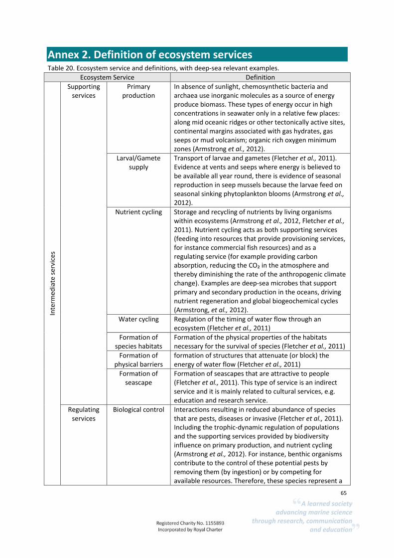
65
Annex 2. Definition of ecosystem services Table 20. Ecosystem service and definitions, with deep-sea relevant examples.
Ecosystem Service Definition
Inte
rmed
iate
ser
vice
s
Supporting services
Primary production
In absence of sunlight, chemosynthetic bacteria and archaea use inorganic molecules as a source of energy produce biomass. These types of energy occur in high concentrations in seawater only in a relative few places: along mid oceanic ridges or other tectonically active sites, continental margins associated with gas hydrates, gas seeps or mud volcanism; organic rich oxygen minimum zones (Armstrong et al., 2012).
Larval/Gamete supply
Transport of larvae and gametes (Fletcher et al., 2011). Evidence at vents and seeps where energy is believed to be available all year round, there is evidence of seasonal reproduction in seep mussels because the larvae feed on seasonal sinking phytoplankton blooms (Armstrong et al., 2012).
Nutrient cycling Storage and recycling of nutrients by living organisms within ecosystems (Armstrong et al., 2012, Fletcher et al., 2011). Nutrient cycling acts as both supporting services (feeding into resources that provide provisioning services, for instance commercial fish resources) and as a regulating service (for example providing carbon absorption, reducing the CO₂ in the atmosphere and thereby diminishing the rate of the anthropogenic climate change). Examples are deep-sea microbes that support primary and secondary production in the oceans, driving nutrient regeneration and global biogeochemical cycles (Armstrong, et al., 2012).
Water cycling Regulation of the timing of water flow through an ecosystem (Fletcher et al., 2011)
Formation of species habitats
Formation of the physical properties of the habitats necessary for the survival of species (Fletcher et al., 2011)
Formation of physical barriers
formation of structures that attenuate (or block) the energy of water flow (Fletcher et al., 2011)
Formation of seascape
Formation of seascapes that are attractive to people (Fletcher et al., 2011). This type of service is an indirect service and it is mainly related to cultural services, e.g. education and research service.
Regulating services
Biological control Interactions resulting in reduced abundance of species that are pests, diseases or invasive (Fletcher et al., 2011). Including the trophic-dynamic regulation of populations and the supporting services provided by biodiversity influence on primary production, and nutrient cycling (Armstrong et al., 2012). For instance, benthic organisms contribute to the control of these potential pests by removing them (by ingestion) or by competing for available resources. Therefore, these species represent a

66
buffer for environmental changes and ecological shifts and this reduces the probability that the pathogens develop (Armstrong, et al., 2012).
Natural hazard regulation
Regulating the formation of physical barriers service
Regulation of water & sediment
quality
Regulation of the removal of contaminants from water flowing through an ecosystem (Fletcher et al., 2011).
Carbon sequestration
Large, slowly-changing store of carbon (Armstrong et al., 2012). For instance, marine organisms act as a reserve or sink for carbon in living tissue and by facilitating burial of carbon in seabed sediments (Armstrong t al 2012). Through this natural carbon sequestration and storage process, the deep-sea provides a climate regulation services (Armstrong et al., 2012).
Go
dd
s/B
enef
its
Provisioning services
Fish and shellfish The interaction between species related to food consumption (Fletcher et al., 2011). The deep-sea despite its limited primary production is a source of several commercial species of both fish and shellfish (Armstrong et al., 2012).
Ornamental materials
This is likely to be no relevant in deep-sea context. This service is defined as "any material that is extracted for use in decoration, fashion, handicrafts, souvenirs, etc." (Hattam, et al., 2014).
Genetic resources Deep-sea compounds used for pharmaceutical products; the uses of marine derived compounds are varied, including potential uses in the industrial and medical realms (from microorganisms or stationary bottom-dwelling organisms such as corals and sponges) (Armstrong et al., 2012)
Regulating services
Climate regulation A series of biogeochemical processes regulated by living marine organisms, which include the so-called biological pump, a series of biologically-mediated processes that transport organic material (carbon and other nutrients) from the ocean surface to deeper layers (Armstrong et al., 2012). This includes marine organisms that act as a reserve or sink for carbon in living tissue and by facilitating burial of carbon in seabed sediments (Armstrong et al., 2012). Linked to 'carbon sequestration' service.
Natural hazard protection
Final service of the formation of physical barriers service.
Clean water and sediments
Removal of contaminants from water flowing through an ecosystem (Fletcher et al., 2011)
Cultural services
Tourism/Nature watching
Specific recreational activities that are dependent on different features within the natural environment. All benefit from general environmental quality and species
67
abundance and marine health, in addition to different activities relying on different marine features (Thurber et al., 2014).
Aesthetic benefits Most direct aesthetic uses of deep-sea environments are limited, since we do not access them directly (Armstrong et al., 2012).
Education and research
Educational value and the economic benefits to inspirational services such as literature and entertainment. The mystery and great unknown of the deep-ocean realm provide strange facts, contributing to public and scientific knowledge (Thurber et al., 2014).

68
Annex 3. Ecosystem service matrices Table 21. Deep-sea ecosystem service matrix.
Intermediate Services Final Ecosystem Services
Supporting services Regulating Provisioning Regulating Cultural
EUNIS code 2007 P
rim
ary
pro
du
ctio
n
Larv
al/G
amet
e su
pp
ly
Nu
trie
nt
cycl
ing
Wat
er c
yclin
g
Form
atio
n o
f sp
ecie
s h
abit
ats
Form
atio
n o
f p
hys
ical
bar
rier
s
Form
atio
n o
f se
asca
pe
Bio
logi
cal c
on
tro
l
Nat
ura
l haz
ard
reg
ula
tio
n
Reg
ula
tio
n o
f w
ater
& s
edim
ent
qu
alit
y
Car
bo
n s
equ
estr
atio
n
Fish
an
d s
hel
lfis
h
Alg
ae a
nd
sea
wee
d
Orn
amen
tal m
ater
ials
Gen
etic
res
ou
rces
Wat
er s
up
ply
Clim
ate
regu
lati
on
Nat
ura
l haz
ard
pro
tect
ion
Cle
an w
ater
an
d s
edim
ents
Tou
rism
/Nat
ure
wat
chin
g
Aes
thet
ic b
enef
its
Edu
cati
on
A6.11 Deep-sea bedrock
3 2 3
3 3 1
1 1
1
1 1 1 1
A6.14 Boulders on the deep-sea
bed
3 2 3
3 3
1
1 2
1
1
1 1 1
A6.2 Deep-sea mixed substrata
3 2 3
3 3 1
1 2
1
1 1 1 1
A6.22 Deep-sea biogenic
gravels (shells, coral
debris)
3 2 3
3 3
1
1 1
1
1
1 1 1 A6.3 Deep-sea sand
3 3 3
3 3 1
1 1 3
1
1 1 1 1
A6.4 Deep-sea muddy
sand 3 3 3
3 3
1
1 1 3
1
1 1 1 1
A6.5 Deep-sea mud
3 3 3
3 3 1
1 1 3
1
1
1 1 1 A6.52
Communities of abyssal
muds
3 3 3
3 3
1
1 1 3
1
1
1 1 1
A6.6 Deep-sea bioherms
3 3 3
3 3 1
2 1 2
2
3
2 1 1 1
A6.61 Communities of deep-sea
corals
3 3 3
3 3
1
2 1 2
2
3
2
1 1 1
A6.611 Deep-sea Lophelia pertusa reefs
3 3 3
3 3 1
2 1 2
1
3
2 1 1 1
A6.62 Deep-sea sponge
aggregations 2
2 2
2
1 1
2
1
1
2
2 1 1 1
A6.621 Facies with
Pheronema grayi 1
2 1
2
1 1
2
1
1
1
2 1 1 1 A6.7 Raised features of
the deep-sea bed
3 3 3 2 2 3
1
2 2 2
2 2
2
2
1 1 1

69
Intermediate Services Final Ecosystem Services
Supporting services Regulating Provisioning Regulating Cultural
EUNIS code 2007 P
rim
ary
pro
du
ctio
n
Larv
al/G
amet
e su
pp
ly
Nu
trie
nt
cycl
ing
Wat
er c
yclin
g
Form
atio
n o
f sp
ecie
s h
abit
ats
Form
atio
n o
f p
hys
ical
bar
rier
s
Form
atio
n o
f se
asca
pe
Bio
logi
cal c
on
tro
l
Nat
ura
l haz
ard
reg
ula
tio
n
Reg
ula
tio
n o
f w
ater
& s
edim
ent
qu
alit
y
Car
bo
n s
equ
estr
atio
n
Fish
an
d s
hel
lfis
h
Alg
ae a
nd
sea
wee
d
Orn
amen
tal m
ater
ials
Gen
etic
res
ou
rces
Wat
er s
up
ply
Clim
ate
regu
lati
on
Nat
ura
l haz
ard
pro
tect
ion
Cle
an w
ater
an
d s
edim
ents
Tou
rism
/Nat
ure
wat
chin
g
Aes
thet
ic b
enef
its
Edu
cati
on
A6.71 Permanently submerged
flanks of oceanic islands
3 2 3 2 2 2
1
2 2 2
2
2
2
1 1 1 A6.72
Seamounts, knolls and
banks
3 3 3 2 2 3
1
2 2 2
2
2 2
1 1 1
A6.721 Summit
communities of seamount,
knoll or bank within euphotic
zone
3 2 3
2 3
1
1 1 2
2 1
1
1 1 1
A6.722 Summit
communities of seamount,
knoll or bank within the
mesopelagic zone, i.e.
interacting with diurnally migrating plankton
2 2 1
2
1 1
1 1 2
1
1 1 1 1
A6.723 Deep summit
communities of seamount,
knoll or bank (i.e. below
mesopelagic zone)
1 2 1
2
1 1
1 1 2
1
1 1 1 1
A6.724 Flanks of seamount, knoll or bank
2 2 2 2 2 1 1
1 1 2
1
1 1 1 1
A6.725 Base of seamount, knoll or bank
2 2 2 2 2 1 1
1 1
1
1 1 1 1
A6.7251 Moat around base of
seamount, knoll or bank
1 2 1
1
2
1 1
1 1
1
1 1 1 1
A6.73 Oceanic ridges
2 1
2 1 2 2 1
1 1 2
1
1 1 1 1
Communities of ridge flanks
1 1 1
2 1 1
1 1 2
1
1 1 1 1
A6.732 Communities of ridge axial trough (i.e. non-vent
1
1 1
2
1 1
1 1
2
1
1 1 1 1

70
Intermediate Services Final Ecosystem Services
Supporting services Regulating Provisioning Regulating Cultural
EUNIS code 2007 P
rim
ary
pro
du
ctio
n
Larv
al/G
amet
e su
pp
ly
Nu
trie
nt
cycl
ing
Wat
er c
yclin
g
Form
atio
n o
f sp
ecie
s h
abit
ats
Form
atio
n o
f p
hys
ical
bar
rier
s
Form
atio
n o
f se
asca
pe
Bio
logi
cal c
on
tro
l
Nat
ura
l haz
ard
reg
ula
tio
n
Reg
ula
tio
n o
f w
ater
& s
edim
ent
qu
alit
y
Car
bo
n s
equ
estr
atio
n
Fish
an
d s
hel
lfis
h
Alg
ae a
nd
sea
wee
d
Orn
amen
tal m
ater
ials
Gen
etic
res
ou
rces
Wat
er s
up
ply
Clim
ate
regu
lati
on
Nat
ura
l haz
ard
pro
tect
ion
Cle
an w
ater
an
d s
edim
ents
Tou
rism
/Nat
ure
wat
chin
g
Aes
thet
ic b
enef
its
Edu
cati
on
fauna)
A6.733 Oceanic ridge
without hydrothermal
effects
1
1 1
2
1 1
1 1
2
1
1 1 1 1
A6.74 Abyssal hills
1 1 1
1 1 1
1 1 1
1
1
1 1 1 A6.75
Carbonate mounds
1 1 1 1
2 1
1 1
1
1 1 1 1
A6.9 Vents, seeps,
hypoxic and anoxic
habitats of the deep-sea
2 2 2 1 2 1
1
1 1
2
1
1 1 1 A6.91 Deep-sea reducing
habitats 2 2
1
2 1 1
1 1
1
1 1 1 1
A6.911 Seeps in the deep-
sea bed 2 2
1
2 1 1
1 1
1
1 1 1 1
A6.912 Gas hydrates in deep-sea 2
2 1
2 1 1
1 1
1
1 1 1 1
A6.913 Cetacean and
other carcasses on the deep-sea
bed
2 2 1
2 1
1
1 1
1
1 1 1 1
Deep-sea bed influenced by hypoxic water
column
1
1 1
1 1
1
1 1
1
1 1 1 1
A6.93 Isolated ‘oceanic’ features
influenced by hypoxic water
column
1
1 1
1 1
1
1 1
1
1 1 1 1 A6.94 Vents in the deep-
sea 2
1 2 1 2 1
1
1 2
2
1 1 1 1
A6.941 Active vent fields 2 1 1 1
2 1 1
1 1
1
1 1 1 1
A6.942 Inactive vent
fields 1 1 1 1 1
1 1 1 1 1 1 1 1
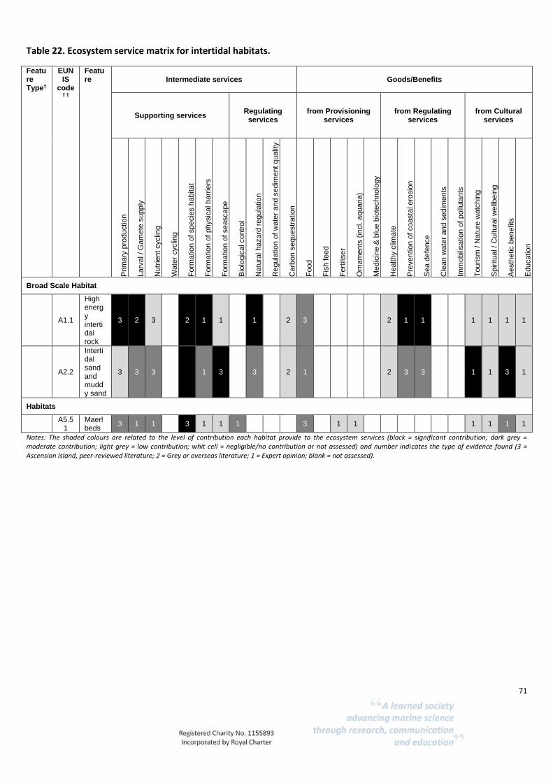
71
Table 22. Ecosystem service matrix for intertidal habitats.
Feature Type†
EUNIS
code † †
Feature Intermediate services Goods/Benefits
Supporting services Regulating
services from Provisioning
services from Regulating
services from Cultural
services P
rim
ary
pro
ductio
n
Larv
al / G
am
ete
supply
Nutr
ient cyclin
g
Wate
r cyclin
g
Fo
rma
tio
n o
f specie
s h
abitat
Fo
rma
tio
n o
f physic
al barr
iers
Fo
rma
tio
n o
f seascape
Bio
logic
al contr
ol
Natu
ral hazard
regula
tio
n
Regula
tio
n o
f w
ate
r and s
edim
ent qualit
y
Carb
on s
equestr
atio
n
Fo
od
Fis
h f
eed
Fe
rtili
ser
Orn
am
ents
(in
cl. a
quaria
)
Me
dic
ine &
blu
e b
iote
chnolo
gy
Healthy c
lima
te
Pre
ventio
n o
f coasta
l ero
sio
n
Sea d
efe
nce
Cle
an w
ate
r and s
edim
ents
Imm
obili
satio
n o
f pollu
tants
To
urism
/ N
atu
re w
atc
hin
g
Spiritual / C
ultura
l w
ellb
ein
g
Aesth
etic b
enefits
Educatio
n
Broad Scale Habitat
A1.1
High energy intertidal rock
3 2 3 2 1 1 1 2 3 2 1 1 1 1 1 1
A2.2
Intertidal sand and muddy sand
3 3 3 3 1 3 3 2 1 2 3 3 1 1 3 1
Habitats
A5.5
1 Maerl beds
3 1 1 3 1 1 1 3 1 1 1 1 1 1
Notes: The shaded colours are related to the level of contribution each habitat provide to the ecosystem services (black = significant contribution; dark grey = moderate contribution; light grey = low contribution; whit cell = negligible/no contribution or not assessed) and number indicates the type of evidence found (3 = Ascension Island, peer-reviewed literature; 2 = Grey or overseas literature; 1 = Expert opinion; blank = not assessed).

72
Annex 4. Sensitivity matrices Table 23. Sensitivity matrices for deep-sea habitats and features based on project MB0102 sensitivity assessments (Tillin et al., 2010).
Feature
pH
chan
ges
Temp
erature ch
anges (regio
nal)
Water flo
w
Wave exp
osu
re chan
ges -
Temp
erature ch
anges - lo
cal
Salinity ch
anges - lo
cal
Water flo
w (tid
al curren
t) chan
ges -
local
Water clarity ch
anges
De-o
xygenatio
n
Nitro
gen an
d p
ho
sph
oru
s en
richm
ent
Organ
ic enrich
men
t
Ph
ysical chan
ge (to an
oth
er seabed
)
Ph
ysical loss
Siltation
rate chan
ges (Low
)
Siltation
rate chan
ges High
Pen
etration
and
/or d
isturb
ance
Shallo
w ab
rasion
/pen
etration
: dam
age
Surface ab
rasion
: s
Ph
ysical remo
val (extraction
)
Rem
oval o
f target species
Rem
oval o
f no
n-target sp
ecies
Deep-sea rock and artificial hard substrata
NA M NS NE NE NE NE NE NS NS NS H NE NS NS H NS NS H NS NS
Deep-sea Mixed substrata
NA NS NA NA NA NA NA NA NS NS NS H NE H NA H H H NA NA NA
Deep-sea sand NA M NA NA NA NA NA NA NA NA NA H H NA H H H
NA NA NA
Deep-sea muddy sand
NA M NA NE NE NE NE NE NS NS NA H NE NA NA
H H H NA NA N
A
Deep-sea Mud NA M NA NE NE NE NE NE H H H H H H
NS-H
H L H
Deep-sea bioherms
NA M H NE NE NE NE NE NS H H H H H H H H H
Communities of deep-sea corals NA M H NE H H H NS NS NS H H H
M-H
H H H H H NS H
Deep-sea [Lophelia pertusa] reefs NA M H NE H H H
NS-H
H NS H H H M-H
H H H H H NS H
Deep-sea sponge aggregations
NA M H NE H H NE NS NS NS H H NE H H H H H H NE H
Raised features of the deep-sea bed
NA M H NE NE NE NE NS NS NS NS-H
H NE H H H H H H NS H
Seamounts, knolls and banks H H H H NS NA NA NE NS NS
NS-H
H NE H H H H H H NS H
Oceanic ridges
H H H H NS NA NA NE NS NS NS-H
H NE H H H H H H NS H
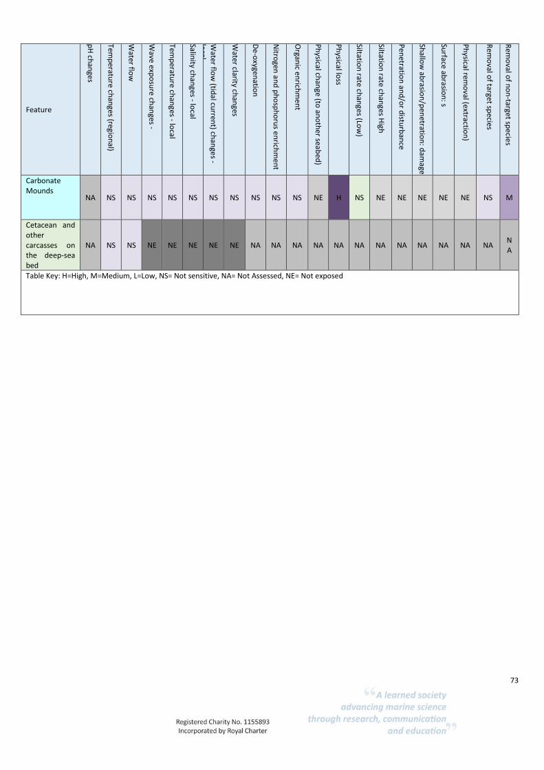
73
Feature
pH
chan
ges
Temp
erature ch
anges (regio
nal)
Water flo
w
Wave exp
osu
re chan
ges -
Temp
erature ch
anges - lo
cal
Salinity ch
anges - lo
cal
Water flo
w (tid
al curren
t) chan
ges -
local
Water clarity ch
anges
De-o
xygenatio
n
Nitro
gen an
d p
ho
sph
oru
s en
richm
ent
Organ
ic enrich
men
t
Ph
ysical chan
ge (to an
oth
er seabed
)
Ph
ysical loss
Siltation
rate chan
ges (Low
)
Siltation
rate chan
ges High
Pen
etration
and
/or d
isturb
ance
Shallo
w ab
rasion
/pen
etration
: dam
age
Surface ab
rasion
: s
Ph
ysical remo
val (extraction
)
Rem
oval o
f target species
Rem
oval o
f no
n-target sp
ecies
Carbonate Mounds
NA NS NS NS NS NS NS NS NS NS NS NE H NS NE NE NE NE NE NS M
Cetacean and other carcasses on the deep-sea bed
NA NS NS NE NE NE NE NE NA NA NA NA NA NA NA NA NA NA NA NA NA
Table Key: H=High, M=Medium, L=Low, NS= Not sensitive, NA= Not Assessed, NE= Not exposed

74
Table 24. Intertidal vulnerability matrix (Based on MarESA assessments available from MarLIN, www.marlin.ac.uk)
EUNIS Level 4 EUNIS name
2007
Ab
rasion
/distu
rban
ce of th
e sub
strate on
the su
rface of th
e seabe
d
Ch
ange
s in su
spen
de
d so
lids (w
ater clarity)
Deo
xygenatio
n
Emergen
ce regime ch
ange
s, inclu
din
g tidal level ch
ange co
nsid
eration
s
Gen
etic mo
dificatio
n &
translo
cation
of in
digen
ou
s specie
s
Hab
itat structu
re chan
ges - rem
oval o
f sub
stratum
(extraction
)
Intro
du
ction
of ligh
t
Intro
du
ction
of m
icrob
ial path
ogen
s
Intro
du
ction
of o
ther su
bstan
ces (solid
, liqu
id o
r gas)
Intro
du
ction
or sp
read o
f invasive n
on
-ind
igen
ou
s specie
s (INIS)
Organ
ic enrich
men
t
Pen
etration
and
/or d
isturb
ance o
f the su
bstrate b
elo
w th
e surface o
f the
seabe
d, in
clud
ing ab
rasion
Ph
ysical chan
ge (to an
oth
er sed
imen
t type)
Rem
oval o
f target species
Salinity d
ecrease
Salinity in
crease
Smo
therin
g and
siltation
rate chan
ges (Heavy)
Smo
therin
g and
siltation
rate chan
ges (Light)
A1.12 Robust fucoid and/or red seaweed communities
A1.122 Corallina officinalis on exposed to moderately exposed lower eulittoral rock
L NS NS M NE NR
NS NS NS NS NS NR
NR
L M M M NS
A1.41 Communities of littoral rockpools
A1.411 Coralline crust-dominated shallow eulittoral rockpools
L NS NS L NR
NR
L NS NS H NS NR
NR
L M M M M
A1. 414 Hydroids, ephemeral seaweeds and Littorina littorea in shallow eulittoral mixed substrata pools
L NS NS L NR
M NS NS NS H NS L NR
L NS NS L L
A1.42 Communities of rockpools in the supralittoral zone
A1.421 Green seaweeds (Enteromorpha spp. and Cladophora spp.) in shallow upper shore rockpools
L NS NS L NS NR
NS NS NS NS NS NR
NR
L NS NS L L
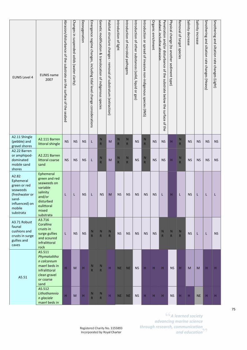
75
EUNIS Level 4 EUNIS name
2007
Ab
rasion
/distu
rban
ce of th
e sub
strate on
the su
rface of th
e seabe
d
Ch
ange
s in su
spen
de
d so
lids (w
ater clarity)
Deo
xygenatio
n
Emergen
ce regime ch
ange
s, inclu
din
g tidal level ch
ange co
nsid
eration
s
Gen
etic mo
dificatio
n &
translo
cation
of in
digen
ou
s specie
s
Hab
itat structu
re chan
ges - rem
oval o
f sub
stratum
(extraction
)
Intro
du
ction
of ligh
t
Intro
du
ction
of m
icrob
ial path
ogen
s
Intro
du
ction
of o
ther su
bstan
ces (solid
, liqu
id o
r gas)
Intro
du
ction
or sp
read o
f invasive n
on
-ind
igen
ou
s specie
s (INIS)
Organ
ic enrich
men
t
Pen
etration
and
/or d
isturb
ance o
f the su
bstrate b
elo
w th
e surface o
f the
seabe
d, in
clud
ing ab
rasion
Ph
ysical chan
ge (to an
oth
er sed
imen
t type)
Rem
oval o
f target species
Salinity d
ecrease
Salinity in
crease
Smo
therin
g and
siltation
rate chan
ges (Heavy)
Smo
therin
g and
siltation
rate chan
ges (Light)
A2.11 Shingle (pebble) and gravel shores
A2.111 Barren littoral shingle
NS NS NS L NR
M NR
NR
NS NR
NS NS H NR
NS NS NS NS
A2.22 Barren or amphipod-dominated mobile sand shores
A2.221 Barren littoral coarse sand
NS NS NS L NR
M NR
NR
NS NR
NS NS H NR
NS NS NS NS
A2.82 Ephemeral green or red seaweeds (freshwater or sand-influenced) on mobile substrata
Ephemeral green and red seaweeds on variable salinity and/or disturbed eulittoral mixed substrata
L L NS L NS M NS NS NS NS NS L H L NS L L L
A3.71 Robust faunal cushions and crusts in surge gullies and caves
A3.716 Coralline crusts in surge gullies and scoured infralittoral rock
L NS NS NR
NR
NR
NS NS NS NS NS NR
NR
NR
NS L L NS
A5.51
A5.511 Phymatolithon calcareum maerl beds in infralittoral clean gravel or coarse sand
H M H NR
NR
H NE NE NS H H H NS H M M H H
A5.512 Lithothamnion glaciale maerl beds in
H M H NR
NR
H NE NE NS H H H NS H H NE H H

76
EUNIS Level 4 EUNIS name
2007
Ab
rasion
/distu
rban
ce of th
e sub
strate on
the su
rface of th
e seabe
d
Ch
ange
s in su
spen
de
d so
lids (w
ater clarity)
Deo
xygenatio
n
Emergen
ce regime ch
ange
s, inclu
din
g tidal level ch
ange co
nsid
eration
s
Gen
etic mo
dificatio
n &
translo
cation
of in
digen
ou
s specie
s
Hab
itat structu
re chan
ges - rem
oval o
f sub
stratum
(extraction
)
Intro
du
ction
of ligh
t
Intro
du
ction
of m
icrob
ial path
ogen
s
Intro
du
ction
of o
ther su
bstan
ces (solid
, liqu
id o
r gas)
Intro
du
ction
or sp
read o
f invasive n
on
-ind
igen
ou
s specie
s (INIS)
Organ
ic enrich
men
t
Pen
etration
and
/or d
isturb
ance o
f the su
bstrate b
elo
w th
e surface o
f the
seabe
d, in
clud
ing ab
rasion
Ph
ysical chan
ge (to an
oth
er sed
imen
t type)
Rem
oval o
f target species
Salinity d
ecrease
Salinity in
crease
Smo
therin
g and
siltation
rate chan
ges (Heavy)
Smo
therin
g and
siltation
rate chan
ges (Light)
tide-swept variable salinity infralittoral gravel
Table Key: H=High, M=Medium, L=Low, NS= Not sensitive, NA= Not Assessed, NE= Not exposed
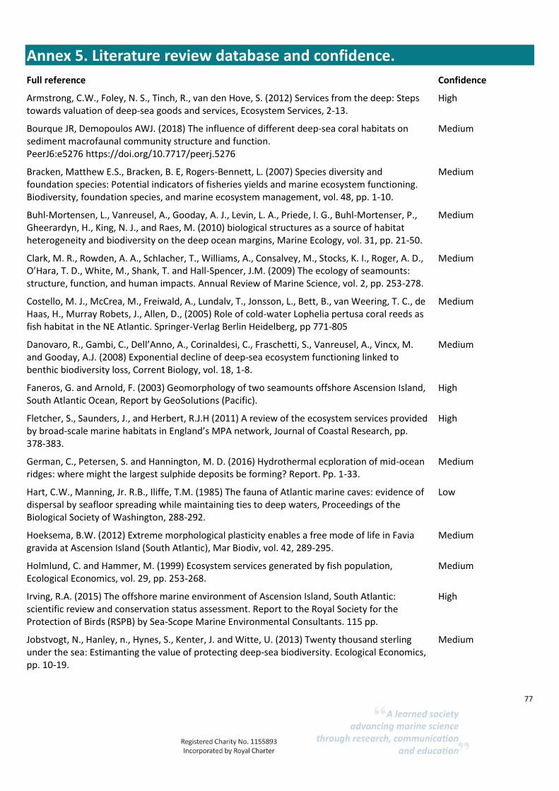
77
Annex 5. Literature review database and confidence.
Full reference Confidence
Armstrong, C.W., Foley, N. S., Tinch, R., van den Hove, S. (2012) Services from the deep: Steps towards valuation of deep-sea goods and services, Ecosystem Services, 2-13.
High
Bourque JR, Demopoulos AWJ. (2018) The influence of different deep-sea coral habitats on sediment macrofaunal community structure and function. PeerJ6:e5276 https://doi.org/10.7717/peerj.5276
Medium
Bracken, Matthew E.S., Bracken, B. E, Rogers-Bennett, L. (2007) Species diversity and foundation species: Potential indicators of fisheries yields and marine ecosystem functioning. Biodiversity, foundation species, and marine ecosystem management, vol. 48, pp. 1-10.
Medium
Buhl-Mortensen, L., Vanreusel, A., Gooday, A. J., Levin, L. A., Priede, I. G., Buhl-Mortenser, P., Gheerardyn, H., King, N. J., and Raes, M. (2010) biological structures as a source of habitat heterogeneity and biodiversity on the deep ocean margins, Marine Ecology, vol. 31, pp. 21-50.
Medium
Clark, M. R., Rowden, A. A., Schlacher, T., Williams, A., Consalvey, M., Stocks, K. I., Roger, A. D., O’Hara, T. D., White, M., Shank, T. and Hall-Spencer, J.M. (2009) The ecology of seamounts: structure, function, and human impacts. Annual Review of Marine Science, vol. 2, pp. 253-278.
Medium
Costello, M. J., McCrea, M., Freiwald, A., Lundalv, T., Jonsson, L., Bett, B., van Weering, T. C., de Haas, H., Murray Robets, J., Allen, D., (2005) Role of cold-water Lophelia pertusa coral reeds as fish habitat in the NE Atlantic. Springer-Verlag Berlin Heidelberg, pp 771-805
Medium
Danovaro, R., Gambi, C., Dell’Anno, A., Corinaldesi, C., Fraschetti, S., Vanreusel, A., Vincx, M. and Gooday, A.J. (2008) Exponential decline of deep-sea ecosystem functioning linked to benthic biodiversity loss, Corrent Biology, vol. 18, 1-8.
Medium
Faneros, G. and Arnold, F. (2003) Geomorphology of two seamounts offshore Ascension Island, South Atlantic Ocean, Report by GeoSolutions (Pacific).
High
Fletcher, S., Saunders, J., and Herbert, R.J.H (2011) A review of the ecosystem services provided by broad-scale marine habitats in England’s MPA network, Journal of Coastal Research, pp. 378-383.
High
German, C., Petersen, S. and Hannington, M. D. (2016) Hydrothermal ecploration of mid-ocean ridges: where might the largest sulphide deposits be forming? Report. Pp. 1-33.
Medium
Hart, C.W., Manning, Jr. R.B., Iliffe, T.M. (1985) The fauna of Atlantic marine caves: evidence of dispersal by seafloor spreading while maintaining ties to deep waters, Proceedings of the Biological Society of Washington, 288-292.
Low
Hoeksema, B.W. (2012) Extreme morphological plasticity enables a free mode of life in Favia gravida at Ascension Island (South Atlantic), Mar Biodiv, vol. 42, 289-295.
Medium
Holmlund, C. and Hammer, M. (1999) Ecosystem services generated by fish population, Ecological Economics, vol. 29, pp. 253-268.
Medium
Irving, R.A. (2015) The offshore marine environment of Ascension Island, South Atlantic: scientific review and conservation status assessment. Report to the Royal Society for the Protection of Birds (RSPB) by Sea-Scope Marine Environmental Consultants. 115 pp.
High
Jobstvogt, N., Hanley, n., Hynes, S., Kenter, J. and Witte, U. (2013) Twenty thousand sterling under the sea: Estimanting the value of protecting deep-sea biodiversity. Ecological Economics, pp. 10-19.
Medium

78
Koslow, J. A., Gowlett-Holmes, K., Lowry, J.K., O’Hara, T., Poore, G.C.B., Williams, A. (2001) Seamount benthic macrofauna off southern Tasmania: community structure and impacts of trawling, Marine Ecology Progress Series, vol. 213, pp. 111-125.
Medium
Kvile, K., Taranto, G. H., Pitcher, T. J., Morato, T. (2014) A global assessment of seamount ecosystems knowledge using an ecosystem evaluation framework, Biological Conservation, vol. 173, pp. 108-120.
Medium
Le, J. T., Levin, L. A. , Carson, R.A. (2017) Incorporating ecosystem services into environmental management of deep-seabed mining, Deep-sea Research Part II: Topical Studies in Oceanography, vol.137, pp. 486-503.
Medium
Leduc, D., Rowden, A. A., Pilditch, C. A., Maas, E. W., & Probert, P. K. (2013). Is there a link between deep-sea biodiversity and ecosystem function? Marine Ecology, published online 17 April 2013.
Medium
Levin, L.A. and Sibuet, M. (2012) Understanding continental margin biodiversity: a new imperative, (Annual Review of Marine Science, pp. 79-112.
Medium
Millennium Ecosystem Assessment, 2005. Ecosystems and Human Well-being: Synthesis. Island Press, Washington, DC.
Medium
Morato, T., Bulman, C., Pitcher, T. J. (2009) Modelled effects of primary and secondary production enhancement by seamounts on local fish stocks. Deep-sea Research II, vol. 56, pp. 2713-2719.
Medium
Nolan, E. T., Barnes, D. K. A., Brown, J., Downes, K., Enderlein, P., Gowland, E., Hogg, O. T., Laptikhovsky, V., Morley, S. A., Mrowicki, R. J., Richardson, A., Sands, C. J., Weber, N., Weber, S. and Brickle, P. (2017) “Biological and physical characterization of the seabed surrounding Ascension Island from 100–1000 m,” Journal of the Marine Biological Association of the United Kingdom. Cambridge University Press, 97(4), pp. 647–659. doi: 10.1017/S0025315417000820
High
Pereira-Filho, G. H., Amado-Filho, G.M., de Moura, R.L., Bastos, A.C., Guimaraes, S.M.P.B., Salgado, L.T., Francini-Filho, R.B., Bahia, R.G., Abrantes, D.P., Guth, A.Z., and Brasileiro, P.S. (2012) Extensive rhodolith beds cover the summits of Southwestern Atlantic Ocean Seamounts, Journal of Coastal Research, vol. 28 (1), pp. 261-269.
High
Price, J.H., D.M. John, Ascension Island, south Atlantic: A survey of inshore benthic macroorganisms, communities and interactions, Aquatic Botany, Volume 9, 1980, Pages 251-278, ISSN 0304-3770, https://doi.org/10.1016/0304-3770(80)90026-1. (http://www.sciencedirect.com/science/article/pii/0304377080900261)
High
Ramirez-Llodra, E., Brandt, A., Danovaro, R., De Mol. B., Escobar, E., German, C.R., Levin, L. A., Marinez Arbizu, P.,Menot, L., Buhl-Mortensen, P., Narayanaswamy, B.E., Smith, C. R., Tittensor, D.P., Tyler, P.A., Vanreusel, A. and Vecchione, M. (2010) Deep, diverse and definitely different: unique attributes of the world’s largest ecosystem. Biosciences (7), pp. 2851-2899.
High
Roberts, J.M., Wheeler, A., Freiwald, A., Cairns, S., (2009). Cold-Water Corals. Cambridge University Press, Cambridge, UK, 334 pp.
High
Rogers, A. D., 2018. The Biology of Seamounts: 25 Years on, Advances in Marine Biology, https://doi.org/10.1016/bs.amb.2018.06.001
High
Taranto GH, Kvile KØ, Pitcher TJ, Morato T (2012) An Ecosystem Evaluation Framework for Global Seamount Conservation and Management. PLoS ONE 7(8): e42950. doi:10.1371/journal.pone.0042950
High
79
Thrush. S. F. and Dayton, P. K. (2002) Disturbance to marine benthic habitats by trawling and dredging: implications for marine biodiversity. Annual Review of Ecology and Systematics, vol. 33, pp. 449-473.
Medium
Thurber, A.R.; Sweetman, A.K.; Narayanaswamy, B.E.; Jones, D.O.B.; Ingels, J.; Hansman, R.L. (2014) Ecosystem function and services provided by the deep-sea. Biogeosciences, 11 (14). 3941-3963. 10.5194/bg-11-3941-2014
Medium
Van Dover, C. L, Arnaud-Haond, S., Gianni, M., Helmreich, S., Huber, J.A., Jaeckel, A.L., Metaxas, A., Pendleton, L.H., Petersen, S., Ramirez-Llodra, E., Steinberg, P.E., Tunnicliffe, V., Yamamoto, H. (2018) Scientific rationale and international obligations for protection of active hydrothermal vent ecosystems from deep-sea mining, Marine Policy, vol. 90, pp. 20-28.
High
Van Dover, C. L. (2014) Impacts of anthropogenic disturbances at deep-sea hydrothermal vent ecosystems: A review. Marine Environmental Research, vol. 102, pp. 59-72.
High
Wagner, H., Purser, A., Thomsen, L., Jesus, C.C. and Lundalv, T. (2011) Particulate organic matter fluxes and hydrodynamics at the Tisler cold-water coral reef, Journal of Marine Systems, vo. 85, pp.19-29.
Medium
Weslawski, J. M., Snelgrove, P.V.R., Levin, L.A., Austen, M.C., Hawkins, S.J. and Whitlatch, R.B. (2004) Sustaining biodiversity and ecosystem services in soils and sediments, pp. 73-82.
Medium
White M, Wolff GA, Lundälv T, Guihen D, Kiriakoulakis K, Lavaleye M, Duineveld G (2012) Cold-water coral ecosystem (Tisler Reef, Norwegian Shelf) may be a hotspot for carbon cycling. Mar Ecol Prog Ser 465:11-23. https://doi.org/10.3354/meps09888
Low
Wild, C., Mayr, C., Wehrmann, L., Schottner, S., Naumann, M., Hoffmann, F., Rapp, H. T. (2008) Organic matter release by cold water corals and its implication for fauna-microbe interaction, Marine Ecology Progress Series, vol. 372, pp. 67-75.
Medium
Wild, C., Wehrmann, L. M., Mayr, C., Schottner, S.I., Allers, E., Lundalv, T. (2009) Microbial degradation of cold-water coral-derived organic matter: potential implication for organic C cycling in the water column above Tisler Reef, Aquatic Biology, vol. 7, pp. 71-80. doi: 10.3354/ab00185.
Medium
Wirtz, P., Bingeman, J., Bingeman, J., Fricke, R., Hook, T. J. and Young, J. (2014) the fishes of Ascension Island, central Atlantic Ocean – new records and an annotated checklist, Journal of the Marine Biological Association of the United Kingdom, vol. 97 (4) pp. 783-798.
High
Zeppilli, D., Pusceddu, A., Trincardi, F. and Danovaro, R. (2016) Seafloor heterogeneity influences the biodiversity-ecosystem functioning relationships in the deep-sea, Scientific Reports, pp. 1-12.
Medium

80
Annex 6. Summary of habitat data supplied to project. Table 25. Summary of datasets supplied to the project team.
Title Lineage Use Constraints Data
Format
1:25 000
Ascension
Island Base Map
Map printed by Military Survey, UK (Series: G892, Sheet: Ascension Island, Edition: 4-
GSGS), scanned by Ian Fisher, RSPB and georeferenced by Alan Mills. First edition
published by Directorate of Overseas Surveys in 1964 (DOS 327) and revised as a topographic information overprint in 1982 and 1985 by the Director of Military Survey.
Edition 4 revised by Ordnance Survey in 1992: converted to WGS84 from local datum and International Spheroid and revised from RAF photography dated 1989 with additional
information from 1:2400 Ascension Island map, PSA DOE 1987 and field reports.
Crown copyright restrictions
apply. Please contact Ordnance
Survey of Great Britain for further details.
GeoTIFF
Admiralty
Chart of Ascension
Island
Data derived from Admiralty surveys and Ministry of Public Building and Works surveys
between 1826 and 1984.
Crown copyright restrictions
apply. Please contact the UK Hydrographic Office for further
details.
Disc Image
File
Admiralty
Chart of
English Bay
Data based on Admiralty surveys and Ministry of Public Building and Works surveys
conducted between 1908 and 1984.
Crown copyright restriction
apply. Please contact the UK
Hydrographic Office for further
details.
Disc Image
File
Admiralty
Chart -
Clarence Bay to South West
Bay
Based on data collected during Admiralty surveys and Ministry of Public Building and
Works Surveys between 1908 and 1984. Chart published in 1994 by the UK Hydrographic
Office and digitised in 2005 by AIG Conservation Department.
Crown copyright restrictions
apply. Please contact the UK
Hydrographic Office for further information.
Disc Image
File
Island polygon (excluding
stacks)
Coastlines digitised from scanned and georeferenced topographic map and converted to polygon features.
No restrictions apply ESRI Shapefile
Grid lines - 1km
Produced by Alan Mills in 2006. No restrictions apply ESRI Shapefile
Bathymetric
points from
Admiralty charts
Digitised from scanned and georeferenced Admiralty chart (no. 1691) by Alan Mills. Based
on data collected between 1826 and 1984. See metadata records for items AC-CD-2 to AC-
CD-4 for details.
Please cite data source as
Ascension Island Government
Conservation Department
ESRI
Shapefile
Isobaths from
Admiralty charts
Digitised from scanned and georeferenced Admiralty chart (no. 1691) by Alan Mills. Based
on data collected between 1826 and 1984. See metadata records for items AC-CD-2 to AC-CD-4 for details. Isobaths are partial only and should not be used for navigational purposes.
More complete coverage can be found in an interpolated isobath layer (AC-CD-35).
No restrictions apply ESRI
Shapefile
Bathymetric surface (near
shore)
Point bathymetries and isobaths from Admiralty chart no. 1691 (items AC-CD-2 to AC-CD-4) were digitised and the latter converted to point geometries. The multi-level B-spine
interpolation module of SAGA GIS was then used to generate a bathymetric grid from
point depths. Due to the interpolation method used depths are approximate and should not be used for navigational purposes.
Please cite data source as Ascension Island Government
Conservation Department.
ESRI ASCII Grid
Nearshore
isobaths (interpolated)
Extracted from a bathymetric surface generated from Admiralty charts of Ascension Island
(AC-CD-34). Isobaths generated using the raster extraction contour tool in QGIS version 2.2.0.
Please cite data source as
Ascension Island Government Conservation Department
ESRI
Shapefile
Sublittoral zone Produced using isobaths generated from a bathymetric surface of Ascension Island's near
shore waters (AC-CD-35). Bathymetric surface was in turn derived from digitised Admiralty charts (see AC-CD-34 for details). Due to processing methods, depths are
approximate only and should not be used for navigational purposes or other applications
requiring precise bathymetry.
No restrictions apply ESRI
Shapefile
Bathymetric
surface (EEZ)
2014 gridded bathymetry data downloaded from the General Bathymetric Chart of the
Oceans (http://www.gebco.net/) and clipped.
British Oceanographic Data
Centre conditions apply. Please
refer to the GEBCO website for details (http://www.gebco.net/).
GeoTIFF
Bathymetry of
the tropical
Atlantic
2014 gridded bathymetry data downloaded from the General Bathymetric Chart of the
Oceans (http://www.gebco.net/) and clipped.
British Oceanographic Data
Centre conditions apply. Please
refer to the GEBCO website for details (http://www.gebco.net/).
GeoTIFF

81
Title Lineage Use Constraints Data
Format
EEZ isobaths Generated from a bathymetric raster layer downloaded from the General Bathymetric Chart
of the Oceans (AC-CD-37) using the raster extraction tools in QGIS version 2.2.0.
Please cite data source as
Ascension Island Government
Conservation Department
ESRI
Shapefile
Tropical
Atlantic
isobaths
Generated from a bathymetric raster layer downloaded from the General Bathymetric Chart
of the Oceans (AC-CD-38) using the raster extraction tools in QGIS version 2.2.0.
Please cite data source Ascension
Island Government Conservation
Department
ESRI
Shapefile
Bathymetry of
the Grattan
Seamount
6 arc-second gridded bathymetry data downloaded from the Seamount Biogeosciences
Network (http://earthref.org/SBN/).
Visit the Seamount
Biogeosciences Network
webpages (http://earthref.org/SBN/) for
copyright restrictions and use
constraints
GeoTIFF
Bathymetry of
the Harris-
Stewart Seamount
6 arc-second gridded bathymetry data downloaded from the Seamount Biogeosciences
Network (http://earthref.org/SBN/).
Visit the Seamount
Biogeosciences Network
webpages (http://earthref.org/SBN/) for
copyright restrictions and use
constraints
GeoTIFF
Grattan
Seamount
isobaths
Extracted from a bathymetric raster layer of the same area downloaded from the Seamount
Biogeosciences Network (see item AC-CD-41). Isobaths generated using the raster
extraction contour tool in QGIS version 2.2.0.
Please cite data source as
Ascension Island Government
Conservation Department.
ESRI
Shapefile
Harris-Stewart
Seamount
isobaths
Extracted from a bathymetric raster layer of the same area downloaded from the Seamount
Biogeosciences Network (see item AC-CD-42). Isobaths generated using the raster
extraction contour tool in QGIS version 2.2.0.
Please cite data source as
Ascension Island Government
Conservation Department
ESRI
Shapefile
Locations of seamounts
Digitised from bathymetric raster layers downloaded from the Seamount Biogeosciences Network and the General Bathymetric Chart of the Oceans (GEBCO).
Please cite data source as Ascension Island Government
Conservation Department
ESRI Shapefile
Tropical Atlantic
bathymetry
polygons
Generated using isobaths extracted from a bathymetric raster of the tropical Atlantic downloaded from the General Bathymetric Chart of the Oceans (see items AC-CD-42 and
AC-CD-42). Isobaths were converted to polygon features and the vector geoprocessing
tools in QGIS version 2.2.0 used to construct depth bands.
Please cite data source as Ascension Island Government
Conservation Department
ESRI Shapefile
Exclusive
economic zone
boundary
Provided by the UK Hydrographic Office, Taunton, Somerset, UK. No restrictions apply ESRI
Shapefile
Territorial sea Produced from AC-CD-8 using the vector geoprocessing tools in QGIS version 2.2.0. A
buffer distance of 22224 m was specified and 99 vertices were used for estimation of the
buffer. Approximate only - boundary needs redrawing using stacks and low-water line from Admiralty charts.
No restrictions apply ESRI
Shapefile
Watersheds Produced by eye pending a formal analysis of drainage patterns using digital elevation
models.
No restrictions apply ESRI
Shapefile
Coastline Digitised from a scanned and georeferenced 1:25000 topographic map of Ascension Island published by Military Surveys UK in 1997.
Please cite data source as Ascension Island Government
Conservation Department
ESRI Shapefile
Turtle nesting beaches
Digitised from a 0.5m resolution WorldView 2 satellite image of Ascension Island. Naming and numbering attributes follow conventions used in the green turtle literature.
'Beaches' at Ladies Loo (beaches 19-20) are omitted as no nesting activity has been
recorded. There is some uncertainty over the boundaries of beaches 7-11 which are contiguous and have been subdivided differently by different researchers. These beaches
are therefore often best considered as a single unit for formal trend analyses. Areas indicate
the extent of sandy habitat and do not reflect the extent of suitable nesting habitat
Please cite data source as Ascension Island Government
Conservation Department
ESRI Shapefile
Grid Cells - 1
degree
Created using the Vector Grid tool in QGIS v 2.6.1 Please cite data source as
Ascension Island Government
Conservation Department
ESRI
Shapefile
Exclusive
economic zone
(polygon)
Generated from item AC-CD-47 using the Vector Geometry Tools in QGIS v2.6.1. Please cite data source as
Ascension Island
Government/UK Hydrographic Office
ESRI
Shapefile

82
Title Lineage Use Constraints Data
Format
Benthic quadrat
images 100-
1000m depth at Ascension
Island
Photo stills resolution 2448 x 2050. Derived data available at metadata record AC-AIGCD-
104. Acknowledge funding sources Blue Marine Foundation and Darwin project
DPLUS021.
Only to be used in accordance
with the terms of a data license
agreement signed with the owner. Acknowledge funding sources
Blue Marine Foundation and
Darwin project DPLUS021.
JPEG