ash canyon acquisition project - nevadaclearinghouse.nv.gov/public/notice/2015/e2015-155.pdfesa...
TRANSCRIPT

Ash Canyon Acquisition Project Environmental Assessment LO-2014-1017
U.S. Department of the Interior Bureau of Reclamation Lahontan Basin Area Office 705 North Plaza Street, Room 320 Carson City, Nevada 89701

Statements
The mission of the Department of the Interior is to protect and provide access to our Nation’s natural and cultural heritage and honor our trust responsibilities to Indian Tribes and our commitments to island communities.
The mission of the Bureau of Reclamation is to manage, develop, and protect water and related resources in an environmentally and economically sound manner in the interest of the American public.

Ash Canyon Acquisition Project i Draft Environmental Assessment
Table of Contents Chapter 1 – Purpose and Need ............................................................................ 1
1.1 Introduction ................................................................................................ 1 1.2 Project Location ......................................................................................... 1 1.3 Proposed Action ......................................................................................... 1 1.4 Need for the Proposed Action .................................................................... 6 1.5 Purpose of the Environmental Analysis ..................................................... 6 1.6 Legal, Statutory, and Regulatory Authorities Relevant to the Proposed Federal Action ............................................................................................ 7
Chapter 2 – Proposed Action and Alternatives .................................................. 7 2.1 No Action ................................................................................................... 7 2.2 Proposed Action ......................................................................................... 8 2.3 Alternatives Considered but Eliminated from Further Evaluation ............ 8
Chapter 3 – Affected Environment and Environmental Consequences .......... 8 3.1 Introduction ................................................................................................ 8 3.2 Land Use .................................................................................................... 9
3.2.1 Affected Environment ..........................................................................9 3.2.2 Environmental Consequences ............................................................11
3.3 Biological Resources ............................................................................... 12 3.3.1 Affected Environment ........................................................................12 3.3.2 Environmental Consequences ............................................................14
3.4 Physical Resources................................................................................... 15 3.4.1 Affected Environment ........................................................................15 3.4.2 Environmental Consequences ............................................................16
3.5 Cultural Resources ................................................................................... 17 3.5.1 Affected Environment ........................................................................17 3.5.2 Environmental Consequences ............................................................17
3.6 Indian Trust Assets .................................................................................. 18 3.6.1 Affected Environment ........................................................................18 3.6.2 Environmental Consequences ............................................................18
3.7 Climate Change ........................................................................................ 19 3.8 Environmental Justice .............................................................................. 19 3.9 Irreversible and Irretrievable Commitments of Resources ...................... 20 3.10 Cumulative Impacts ............................................................................... 20
3.10.1 Reasonably Foreseeable Future Actions ............................................21 3.10.2 Cumulative Effects.............................................................................21
Chapter 4 – Consultation and Coordination .................................................... 22
Chapter 5 – List of Preparers ............................................................................ 22
Chapter 6 – References ....................................................................................... 23

Ash Canyon Acquisition Project ii Draft Environmental Assessment
List of Figures and Tables
Figure 1. Project Location Map – Regional ............................................................2
Figure 2. Project Location Map – Topographic ......................................................3
Figure 3. Project Location Map – Watershed Basin ...............................................4
Figure 4. Project Site Map – Aerial Photo Imagery ...............................................5
Table 1. Raptor species present at or likely to occur within 3 miles of Hobart Reservoir, Carson County, Nevada, that are Species of Conservation Priority within the State of Nevada. ................................14
Table 2. Selected Demographic Estimates of Carson City and the State of Nevada, 2008–2012 ...............................................................................20
Table 3. List of Past, Present, and Foreseeable Projects and Actions .................21
Appendices
Appendix A – Letters of Support
Appendix B – Vegetation Species List
Appendix C – Nevada Natural Heritage Program Response and Species List
Appendix D – Scoping and Consultation

Ash Canyon Acquisition Project iii Draft Environmental Assessment
Acronyms and Abbreviations APE Area of Potential Effect BLM Bureau of Land Management CCOS Carson City Open Space (Program) CFR Code of Federal Regulations CR Conservation Reserve DTL Desert Terminal Lakes (Program) EA Environmental Assessment ESA Endangered Species Act FLP Forest Legacy Program GBCG Great Basin Consulting Group, LLC ITA Indian Trust Assets LTNSP Lake Tahoe Nevada State Park NDOW Nevada Department of Wildlife NDWR Nevada Division of Water Resources NDEP Nevada Department of Environmental Protection NDF Nevada Division of Forestry NEPA National Environmental Policy Act NFWF National Fish and Wildlife Foundation NHPA National Historic Preservation Act NLT Nevada Land Trust NNHP Nevada Natural Heritage Program NRCS Natural Resources Conservation Service NDSP Nevada Division of State Parks OHV Off-highway vehicle Reclamation Bureau of Reclamation SHPO State Historic Preservation Office USDA U.S. Department of Agriculture USFS U.S. Forest Service USFWS U.S. Fish and Wildlife Service

Ash Canyon Acquisition Project 1 Draft Environmental Assessment
Purpose and Need Chapter 1 –1.1 Introduction This Environmental Assessment (EA) was prepared in accordance with the National Environmental Policy Act of 1969 (NEPA) (42 United States Code 4321–4347), Council on Environmental Quality regulations for implementing the procedural requirements of NEPA (40 Code of Federal Regulations [CFR] 1500–1508), and Department of the Interior NEPA regulations (43 CFR Part 46). This document provides an assessment of the potential impacts to the human environment associated with allowing the use of federal grant funding by the Nevada Land Trust (NLT) for acquisition of 45.5 acres of private land and approximately 20 acre-feet of associated water rights. The acquisition funds would be provided via a sub-grant from the National Fish and Wildlife Foundation (NFWF); the original grant-funding source is the U.S. Bureau of Reclamation’s (Reclamation) Desert Terminal Lakes (DTL) Program. 1.2 Project Location The Ash Canyon property is located in the headwaters of Ash, Sawmill, and Vicee Canyons, Carson County, Nevada (Figures 1–4) at the crest of the Carson Range on the east slope of the Sierra Nevada:
• Township 15 North, Range 19 East, Southeast ¼ of Section 4 • 39°9’50” N/119°45’59” W • Assessor’s Parcel Number 007–601–01 (was 007–091–15)
The property’s eastern boundary generally follows the watershed boundary of Ash and Vicee Canyons to the east, Franktown Creek to the southwest, and Sawmill Canyon to the north. The property is bordered on the west and north by Lake Tahoe Nevada State Park (LTNSP), and on the east and south by Carson City Open Space (CCOS) Program lands. National Forest system lands in the Humboldt-Toiyabe National Forest and Lake Tahoe Basin Management Unit are nearby. The property is within the Carson River and Truckee River watersheds, at 7,800–8,200 feet elevation.
1.3 Proposed Action The proposed action is to allow NLT to use NFWF federal sub-grant funding to purchase a 45.5-acre parcel of private land and approximately 20 acre-feet of associated water rights from a willing seller in Ash Canyon, Carson County, Nevada (Figures 1–4). The grant funding would be used to complete acquisition of the property and transfer of fee title to an appropriate public entity such as the Nevada Division of State Parks (NDSP) or the CCOS Program, both of which are adjacent landholders. The funding would also allow NLT to provide interim

Ash Canyon Acquisition Project 2 Draft Environmental Assessment
protection for a wet meadow on the property by relocating natural materials (logs, boulders) already present on site to block motorized access and prevent ongoing damage (Figure 4). Ground disturbance for the proposed project would be limited to less than 1 acre associated with the proposed barrier construction near the wet meadow. No permanent ground disturbance would occur.
Figure 1. Project Location Map – Regional.

Ash Canyon Acquisition Project 3 Draft Environmental Assessment
Figure 2. Project Location Map – Topographic.

Ash Canyon Acquisition Project 4 Draft Environmental Assessment
Figure 3. Project Location Map – Watershed Basin.

Ash Canyon Acquisition Project 5 Draft Environmental Assessment
Figure 4. Project Site Map – Aerial Photo Imagery.

Ash Canyon Acquisition Project 6 Draft Environmental Assessment
1.4 Need for the Proposed Action As noted in NLT’s grant application to NFWF, the Ash Canyon property has been identified as an important component of a number of local, regional, and state plans in the Carson and Truckee River basins (NLT 2014a). The property is an isolated private inholding bordered by LTNSP and CCOS Program lands. It is also adjacent to Nevada’s first Forest Legacy Program (FLP) project, the Ash Canyon Gateway. The FLP is a federal program which supports state partner efforts to protect environmentally sensitive forest lands. The FLP complements federal and state programs by supporting property acquisition and donated conservation easements (USFS 2015). The Ash Canyon property has been identified as a high priority in the Carson City Open Space Plan (Carson City Open Space Advisory Committee and Carson City Departments of Parks and Recreation and Community Development 2000), which calls for strategic land acquisitions and conservation easements in the Carson Range. The property is accessed and traversed east/west by Ash Canyon Road. The property, which is potentially at risk for private development, is the last private inholding in an area that provides critical road and trail access from the east (Carson City) to the Lake Tahoe Basin and upper elevations of the Sierra Nevada. The property provides the only motorized access from the east to the trailhead for Hobart Reservoir and the Marlette-Hobart Backcountry in LTNSP. Permanent rights-of-way have not been previously acquired for agency or public access. Allowing the use of NFWF sub-grant funds for purchase of the Ash Canyon property would provide a complete landscape of publically owned open space and would preserve public and agency access in upper Ash Canyon and Vicee Canyon. If preserved through acquisition, the property’s high elevation wet meadow would continue to provide downstream water quality and quantity benefits for the public, as well as important wildlife habitat benefits in the Carson and Truckee River watersheds. Recent meadow damage from unmanaged off-highway vehicle (OHV) incursions underscores the need for protection. 1.5 Purpose of the Environmental Analysis The purpose of this EA is to describe the environmental consequences of allowing NFWF to provide federal DTL Program sub-grant funding to the NLT to acquire 45.5 acres of land in the headwaters of Ash Canyon west of Carson City. Acquisition of the land and associated water rights would preserve a critical private land inholding in the Carson and Truckee River watersheds. The purchase of the property would preserve permanent public open space access, enable improved and more consistent management of surrounding public lands, and conserve a high elevation wet meadow water source.

Ash Canyon Acquisition Project 7 Draft Environmental Assessment
1.6 Legal, Statutory, and Regulatory Authorities Relevant to the Proposed Federal Action
Reclamation has provided grant funds to NFWF through Public Law 107–171, as amended by Public Law 110–246, Section 2807; Public Law 111–85, Section 207; and Public Law 112–74, Title II, Division B, Section 208(a) for the following authorized uses: Public Law 107– 171 as amended Sec. 2507 DESERT TERMINAL LAKES. (b) PERMITTED USES. For the benefit of at-risk natural desert terminal lakes and associated riparian and watershed resources, in any case in which there are willing sellers or willing participants, the fund described in subsection (a) may be used –
(1) to lease water; (2) to purchase land, water appurtenant to the land, and related interests; and (3) for efforts consistent with researching, supporting, and conserving fish, wildlife, plant, and habitat resources.
In addition to NEPA and the above Public Law, actions of Reclamation are guided by a number of other statutes, regulations, and agreements, including:
• Endangered Species Act (ESA); • Migratory Bird Treaty Act; • Clean Water Act; • Section 106 of the National Historic Preservation Act (NHPA); and • Other pertinent state, local, or county regulations.
Proposed Action and Chapter 2 –Alternatives
This chapter describes the activities of both the No Action alternative and the Proposed Action. These alternatives have been evaluated with respect to the affected environment, as described in Chapter 3, to provide a clear basis among the options available, from which Reclamation will make its decision. 2.1 No Action Under the No Action alternative, Reclamation would not allow NLT to use NFWF sub-grant funding to acquire the 45.5-acre Ash Canyon property and associated water rights from a willing seller. The property could potentially still be acquired and preserved by NLT or another entity using a different funding source in the future. However, the property could possibly be sold for private

Ash Canyon Acquisition Project 8 Draft Environmental Assessment
development in the meantime, which may eliminate public and agency access to the property and surrounding area. 2.2 Proposed Action The proposed action is to allow NLT to use NFWF sub-grant funding to purchase 45.5 acres of private land and approximately 20 acre-feet of associated water rights from a willing seller in Ash Canyon, Carson County, Nevada (Figures 1 and 2). The grant funding would be used to complete acquisition of the property and transfer of fee title to an appropriate public entity such as NDSP or the CCOS Program, both of which are adjacent landholders. The funding would also allow NLT to provide interim protection for a wet meadow on the property. Specific actions by NLT would include:
• Negotiate and secure a purchase agreement with the landowner; • Complete a due diligence and valuation process, including hiring an
appraiser, coordinating with the landowner, participating in the appraisal review, and completing a Phase I environmental review;
• Coordinate with adjacent and nearby agency landowners (LTNSP, CCOS Program, USFS) and other stakeholders throughout the process;
• Coordinate with prospective future fee title holder to ensure property meets environmental and title criteria; and
• Complete fee title transfer to appropriate governmental agency (e.g., LTNSP or CCOS Program).
After acquisition and before conveyance to a long-term fee title holder, NLT would construct a minimum impact physical barrier to discourage motorized incursion into the wet meadow by relocating natural materials (logs, boulders) already present on site to block motorized access and prevent ongoing damage. 2.3 Alternatives Considered but Eliminated from
Further Evaluation No other alternatives were considered or identified during scoping based on issues or concerns.
Affected Environment and Chapter 3 –Environmental Consequences
3.1 Introduction This chapter describes the existing conditions of the Ash Canyon property and provides an analysis of the potential impacts of implementing the proposed action.

Ash Canyon Acquisition Project 9 Draft Environmental Assessment
The analysis is presented by each resource that may be directly or indirectly affected by the proposed action, consistent with NEPA guidelines. 3.2 Land Use
3.2.1 Affected Environment The Ash Canyon parcel is the last private property inholding in an otherwise contiguous publically owned open space landscape west of Carson City. Other landowners are the State of Nevada (LTNSP), CCOS Program (municipal watershed), and the Humboldt-Toiyabe National Forest. The existing agency landowners work cooperatively to manage the landscape for a variety of beneficial uses including water quality, dispersed recreation, wildlife habitat, fuels management, and vegetation management. Historical Use Some information on the history and current status of the Ash Canyon property is contained in Robison Engineering Company (2014) and summarized here. The current property owner is Tom Marshall. He and the late Bruno Benna acquired the property in 1997 from the Curtis-Wright Corporation. The property may have been part of a much larger private land holding, possibly part of the Whittell Estate. According to Mr. Marshall, U.S. Senator William Sharon of Nevada owned the property in the past. There are no records of formal use of the property, or any development since 1939 other than the Ash Canyon Road and a primitive logging road on the east side of the property. This information was verified by close examination of 75 years of aerial photography. A record search and site visit on September 11, 2014, showed no evidence of hazardous substances on or in the vicinity of the Ash Canyon property (Robison Engineering Company 2014). Access and Recreation Ash Canyon Road is a single-lane improved native surface road about five miles in length. The road begins at the western edge of the Carson City urban interface at 4,900 feet in elevation and terminates at the Carson Range crest at 8,000 feet in elevation (Carson City 2014a). Road maintenance is performed by the Carson City Parks and Recreation Department using specifications and Best Management Practices in the Ash Canyon Maintenance and Erosion Control Plan (Carson City 2014a). The road is not groomed and is not plowed in the winter. Carson City has a 30-foot easement for the Ash Canyon Road across public lands (Carson City 2014a). Although Carson City does not hold a deeded easement across the private Ash Canyon property, it maintains customary use of the road (Carson City 2014a). Ash Canyon Road is designated in the Carson City Unified Pathways Master Plan map (Carson City 2007). In addition to the public, the road is used by adjacent agency land managers, including Carson City, NDSP, Nevada

Ash Canyon Acquisition Project 10 Draft Environmental Assessment
Division of Forestry (NDF), Nevada Department of Wildlife (NDOW), and USFS. Ash Canyon Road traverses the southern part of the property and provides the only public motorized access to the Hobart Reservoir trailhead. Hobart Reservoir is a popular destination in the Marlette-Hobart Backcountry of LTNSP. The Marlette-Hobart Backcountry is the largest and least developed of the LTNSP units and covers the majority of the upper elevations east of State Highway 28 from Spooner Lake north to just beyond Tunnel Creek Road. There are several access points into the backcountry, including Ash Canyon Road, from the east. The primary goal in this backcountry unit is to prevent degradation of the natural conditions and provide opportunities for solitude or primitive recreation. Backcountry “improvements” are limited to primitive administrative access roads, non-motorized trails, signs, and a few primitive campsites (NDSP 2010). Current recreation activity is mostly limited to motorized vehicles (OHV and 4-wheel drive vehicles), mountain bicycles, and foot traffic on Ash Canyon Road. Other seasonal recreational uses include hunting, horseback riding, and fishing access. Ash Canyon Road leads to the Hobart Reservoir trailhead and surrounding recreation lands owned and administered by LTNSP, CCOS Program, and Humboldt-Toiyabe National Forest. User-defined trails exist on the property, which is not currently signed as private property. Occasional motorized incursions into the wet meadow are evident from analysis of recent aerial imagery (Nelson 2014). Non-motorized trails on the property connect to the Tahoe Rim Trail, a 165-mile trail (hiking, mountain biking, equestrian) circling Lake Tahoe, which connects to the 2,650-mile Pacific Crest Trail (hiking, equestrian) (Carson City 2013). Similar to Ash Canyon Road, deeded easements were not acquired for public access on these existing trails. Zoning The Ash Canyon property is zoned as a Conservation Reserve (CR) (Carson City 2014b). This zoning allows a minimum parcel size of 20 acres, and means that the property could be legally subdivided into two parcels (Carson City 2014b). Carson City (2014b) states that the purpose of the CR Use District is to identify the outlying lands that may be developed in the future when water supply, roads, schools, sewer and other public facilities and services are provided for potential development and lands with environmental constraints. The primary permitted uses in a CR are: Accessory farm structure; agricultural use; animals and fowl; fire protection facility; flood control facility; park; residential (limited to 1 dwelling per 20 acres or larger); and water storage facility. Taxes paid on the property in the past 2 years were $363.63 in 2013 and $378.89 in 2014 (Carson City 2014c). The Ash Canyon property is located at the western edge of Carson City’s urban growth boundary.

Ash Canyon Acquisition Project 11 Draft Environmental Assessment
3.2.2 Environmental Consequences No Action The Ash Canyon property is potentially at risk for private development because of its proximity to the Carson City urban area and highly desirable mountain recreation destinations. Sale of the property could eliminate access to publically owned recreation lands adjacent to the property such as Hobart Reservoir and the Tahoe Rim Trail. The only motorized access from the east (Carson City), Ash Canyon Road, could be blocked for recreationists and public land managers. If public access is not blocked, the area may experience gradual increased seasonal use due to increases in public awareness, although use will continue to be limited by future road conditions and maintenance. Property tax revenue from the 45.5 acres of private land would likely continue at approximately the same level (less than $400 per year) unless the property was developed, at which time local tax revenue would likely increase. Almost all noise from the Ash Canyon property is from natural sources, with occasional sounds of visitors using Ash Canyon Road. Current noise levels would not substantially increase unless the property was developed, at which time the type of noise would be related to the type of development. Initial potential noise increases would likely be associated with on-site construction activities. Other low-level noise increases could result from future seasonal residential use and any on-site motorized vehicle use. Similarly potential short- or long-term use of off-grid generators could increase ambient noise from current levels on the property. Potential motorized use associated with accessing the development, operating within the property, or recreating nearby could affect the backcountry environment of adjacent LTNSP, CCOS Program, and Humboldt-Toiyabe National Forest lands, where cross-country motorized travel is not permitted. However, any impacts likely would be minimal due to the low numbers of users. The Ash Canyon property is highly scenic, with a wet meadow surrounded by high elevation conifer forests and a prominent rock outcrop. Scenic quality could be degraded if the property was developed and structures were visible from nearby recreation access routes and vantage points. Proposed Action Permanent future public and agency access would be protected by NLT acquiring the Ash Canyon property and transferring it to one of the adjacent public land management agencies, which are both committed to land stewardship, maintaining recreation access, and cooperative management across boundaries. The scenic quality of the trails and Ash Canyon Road through and adjacent to the property would also be protected. Noise levels would not increase as a result of potential private development and use. The risk of motorized incursions into the Marlette-Hobart Backcountry would not increase because of private motorized use on the property. Non-motorized use could increase slightly when the public

Ash Canyon Acquisition Project 12 Draft Environmental Assessment
becomes aware of the property acquisition and access portions of the property outside the Ash Canyon Road corridor. 3.3 Biological Resources 3.3.1 Affected Environment Vegetation The plants on the Ash Canyon property are typical of high elevation Carson Range-east slope Sierra Nevada species. The three main vegetation types are upper elevation east slope Sierra Nevada mixed conifer forest, mountain meadow (wet), and granitic scree slope (NLT 2014b; Appendix B). The mixed conifer forest is dominated by overstory red fir (Abies magnifica), white fir (Abies concolor), western white pine (Pinus monticola), and Jeffrey pine (Pinus jeffreyi). In moister microclimates and adjacent to the meadow, lodgepole pine (Pinus contorta) is the primary tree species. Primary understory species are greenleaf manzanita (Arctostaphlos patula) and pinedrops (Pterspora andromeda). The forest is primarily second growth as a result of Comstock-era logging, but some old growth trees remain on isolated and steep parts of the property. Similar nearby mixed conifer forest stands have had densities of about 212 trees per acre and an average basal area of 122 square feet per acre (NDF 2007). Forest health is generally good with the exception of the lodgepole pine which show the effects of a past mountain pine beetle (Dendroctonus ponderosae) infestation. Mountain pine beetles are attracted to older, dense stands of lodgepole pine, particularly during drought years (Gibson et al. 2009). Numerous standing and fallen dead trees are evident on the Ash Canyon property. These dead trees provide wildlife habitat (e.g., woodpeckers), but can also be a wildfire hazard in the presence of either natural (e.g., lightning) or anthropogenic ignition sources. The upper elevation portion of the 2004 Waterfall Fire burned through part of the Ash Canyon property on July 16, 2004, primarily as an understory (surface) fire. The fire was caused by an abandoned campfire in the Kings Canyon area and burned 8,723 acres. Further fire spread was prevented by a fuelbreak near Carson City (Bureau of Land Management (BLM) 2004). A separate fuelbreak adjacent to the Ash Canyon property was built on lands recently acquired through the FLP (NDF 2007). The Waterfall Fire and historical fire evidence demonstrate that the Ash Canyon property could benefit from fuel treatment projects. The mountain meadow vegetation type is relatively rare in the eastern Sierra Nevada and Carson Range (Shepperd et al. 2006, Krasnow et al. 2012). The meadow habitat has dominant overstory species of lodgepole pine, Lemmon’s willow (Salix lemmonii), and mountain alder (Alnus tenuifolia). Dominant understory species include gooseberry (Ribes velutinum), wiregrass (Juncus balticus), yarrow (Achillea millefolium), Kentucky bluegrass (Poa pratensis), skunk lily (Veratrum californicum), and various sedges and grasses (NLT 2014b).

Ash Canyon Acquisition Project 13 Draft Environmental Assessment
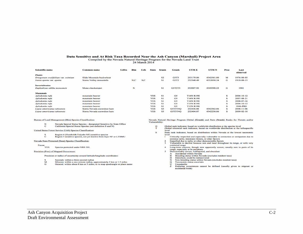
NNHP (2014) reported a 1918 record of Sierra Valley mousetails (Ivesia aperta var. aperta), a USFS Sensitive Species designated plant. However, no sensitive plants were found during a recent botanical survey of the Ash Canyon property (NLT 2014b; Appendix B). Lodgepole pine is encroaching into the perimeter and higher elevations of the meadow in a natural successional pattern that will lead to reduction and eventual elimination of the meadow in the absence of fire or other disturbance. Quaking aspen (Populus tremuloides) is also being negatively affected by encroaching lodgepole pine and fir. Aspen are an important component of mountain meadow edge areas and provide valuable wildlife habitat (Shepperd et al. 2006, Krasnow et al. 2012). The granitic scree slope habitat type had a dominant overstory of Jeffrey pine and understory species of pinemat manzanita (Arctostaphlos nevadensis), phlox (Phlox sp.), Wright’s buckwheat (Eriogonum wrightii), bitterbrush (Purshia tridentata), and Lobb’s buckwheat (Eriogonum lobbii). Federal Protected Species The U.S. Fish and Wildlife Service (USFWS) reported the following Federal listed, proposed, and candidate species as potentially occurring within the Ash Canyon property (USFWS 2014):
• Greater sage-grouse (Centrocercus urophasianus), Bi-State Distinct Population Segment (Proposed Threatened);
• greater sage-grouse, entire population (Candidate); • cui-ui (Chasmistes cujus) (Endangered); and • Lahontan cutthroat trout (Oncorhynchus clarkii henshawi) (Threatened).
None of these species are present or have suitable habitat on or in the vicinity of the Ash Canyon property that could be directly affected by the proposed action. NDOW (2011) reported there were no populations or lek sites of greater sage-grouse in the vicinity of Hobart Reservoir, located 0.5 mile northwest of the Ash Canyon property’s western boundary (Figure 1). In addition, USFWS (2015) withdrew the proposed listing and critical habitat designation for the Bi-State Distinct Population Segment of greater sage-grouse on April 23, 2015. Cui-ui and Lahontan cutthroat trout occur many miles downstream in the Truckee River watershed. The Nevada Natural Heritage Program (NNHP) also provided information on endangered, threatened, candidate, and/or at-risk plant and animal species recorded within 3.1 miles of the Ash Canyon property, and no records of ESA listed, candidate, or proposed species were identified (NNHP 2014; Appendix C). Other Species of Interest NNHP (2014) reported local records of the State-protected mountain beaver (Aplodontia rufa) and Sierra Nevada snowshoe hare (Lepus americanus tahoensis). Habitat might also exist for the following species: Carson Valley

Ash Canyon Acquisition Project 14 Draft Environmental Assessment
silverspot (Speyeria nokomis carsonensis), BLM Sensitive Species; Galena Creek rockcress (Arabis rigidissima demota), USFS Sensitive Species; American marten (Martes americana), USFS Sensitive Species; Trowbridge’s shrew (Sorex trowbridgii), NNHP Imperiled Taxon; and northern rubber boa (Charina bottae), NNHP Vulnerable Taxon (NNHP 2014). Raptor species that have been observed at or are likely to occur near Hobart Reservoir and which are Nevada Species of Conservation Priority (NDOW 2012) are identified in Table 1. USFWS (2014) listed 10 migratory birds of concern in the area: Bald eagle (Haliaeetus leucocephalus), Brewer’s sparrow (Spizella breweri), burrowing owl (Athene cunicularia), calliope hummingbird (Stellula calliope), Cassin’s finch (Carpodacus cassinii), green-tailed towhee (Pipilo chlorurus), olive-sided flycatcher (Contopus cooperi), piñon jay (Gymnorhinus cyanocephalus), sage thrasher (Oreoscoptes montanus), and willow flycatcher (Empidonax traillii) Table 1. Raptor species present at or likely to occur within 3 miles of Hobart
Reservoir, Carson County, Nevada, that are Species of Conservation Prioritya within the State of Nevada.
a NDOW (2012); b NDOW (2011); c bald eagles are closely associated with water (i.e., Hobart Reservoir) and may not utilize habitat on the Ash Canyon property (NDOW 2011).
3.3.2 Environmental Consequences No Action Presently the Ash Canyon property is part of a continuous landscape of undeveloped open space and high quality wildlife habitat. Under the No Action alternative, these conditions may persist for an unknown period of time even if the property is sold to another private party. Depending on the type of future development (if any), the following negative effects to vegetation, wildlife, and wetlands could occur: Introduction of non-native/invasive species (including domestic cats and dogs), increased human activity with noise and disturbance by motorized vehicles, increased risk of wildfire ignition, altering the hydrology of the wet meadow, implementation of wildlife control measures, and removing desirable vegetation and habitat features (snags, large trees, wet areas). As discussed above, there would be no direct effects to federally-protected species or their habitat from the NLT acquisition not being completed.
Common name Scientific name Observed at/near Hobart Reservoir
Within species’ rangeb
northern goshawk Accipiter gentilis X X short-eared owl Asio flammeus - X ferruginous hawk Buteo regalis - X Swainson’s hawk Buteo swainsoni X X bald eaglec Haliaeetus leucocephalus X X flammulated owl Otus flammeolus X X

Ash Canyon Acquisition Project 15 Draft Environmental Assessment
Proposed Action Acquiring and transferring the Ash Canyon property to a public agency would allow the area to be more easily managed as a contiguous landscape through cooperative projects among agencies such as strategic fuelbreaks, prescribed burns, and large-scale habitat improvement activities. The potential negative effects of development on biological resources discussed above would not occur because the property would remain as undeveloped open space. Acquisition of the property would allow important localized projects that benefit biological resources to be carried out. Examples of such projects may include protecting the wet meadow (wetland) from vehicle damage, aspen and willow stand enhancement, curbing lodgepole pine encroachment in the meadow, forest thinning, fuels management, and continued road maintenance. 3.4 Physical Resources 3.4.1 Affected Environment Water The Ash Canyon property is located at the headwaters of the Ash and Vicee Canyon drainages, near the crest of the Carson Range. Average annual precipitation is 35–45 inches per year, most of which is snowfall during the winter (NDF 2007). The property includes a five-acre wet meadow that originates from a spring on the property. The surface of the meadow was wet in late summer 2014 (LaBoa 2014), an exceptional drought year, which indicates a well-functioning wetland with hydrological importance. The meadow is generally intact, but has had recent OHV damage in one area (Nelson 2014). Continued damage can lead to alteration of the hydrological properties of the meadow, including downcutting, channeling and drying. Purchase of the property would include up to 20 acre-feet of water rights. The current landowners have filed a water rights application in this amount to secure ownership of seasonal springs, seeps, and an ephemeral stream located on the property (NLT 2014a). The property is primarily in the Eagle Valley (#104) Administrative Groundwater Basin within the Carson River Basin Hydrographic Region of Nevada (Nevada Division of Water Resources (NDWR) 2014). It is also on the boundary of the Washoe Valley (#89) Administrative Groundwater Basin within the Truckee River Basin Hydrographic Region (NDWR 2014). According to records from the NWDR for a Phase I query, no water wells are on or adjacent to the property (Robison Engineering Consultants 2014). The Phase I assessment estimated the depth to groundwater at 50–100 feet, which would vary seasonally (Robison Engineering Consultants 2014). Ash Canyon is an important municipal water source for Carson City. Carson City maintains a diversion structure located in the lower watershed (Carson City 2014a).

Ash Canyon Acquisition Project 16 Draft Environmental Assessment
Soils The majority of the soils on the Ash Canyon property are mapped as Temo-Witefels outcrop association, which is colluvium derived from granitic parent material on 30–50% slopes. These soils are composed of gravelly coarse sand that has very low water holding capacity. The other major soil type is Toiyabe-Corbett complex, which is also derived from granitic colluvium. Toiyabe-Corbett complex soils are composed of loamy coarse sand, well drained, with slightly better water holding capacity (NRCS 2014). The forest stewardship report for the adjacent “Wilson Property” managed by the CCOS Program notes that soils in the area are susceptible to wind and water erosion if they do not have adequate soil cover such as vegetation and woody material (NDF 2007). Air Air quality in the Ash Canyon property is generally good, typical of undeveloped high elevation areas in the Carson Range and Carson City (BLM 2013, NDEP 2013). The area occasionally may be affected by blowing dust during local wind events or smoke from wildfires and prescribed burns in the Lake Tahoe Basin and Sierra Nevada region. 3.4.2 Environmental Consequences No Action Without acquisition and permanent protection the Ash Canyon property could experience hydrological damage to its wet meadow and spring, increased soil erosion from ground disturbance associated with development activities, increases in water-impermeable areas from hardening surfaces and building structures, and continued risk from wildfire. The water rights associated with the acquisition could no longer be available for maintaining and enhancing watershed and wildlife values. The No Action alternative could result in local air quality effects from development construction activities (e.g., fugitive dust and engine emissions), but predicting those effects are beyond the scope of this analysis. Proposed Action Acquisition and transfer of the Ash Canyon property to an adjoining land management agency would provide an opportunity to protect the wet meadow, avoid soil erosion from potential development activities, reduce soil erosion from inappropriate recreation use, and facilitate fuels treatments that would alleviate risk of damage from wildfire. Under the Proposed Action, the property would be managed as protected open space. Air quality would continue to be a result of natural sources.

Ash Canyon Acquisition Project 17 Draft Environmental Assessment
3.5 Cultural Resources 3.5.1 Affected Environment A cultural resource inventory was completed by Great Basin Consulting Group, LLC (GBCG), a third party cultural resources contractor, on behalf of NLT (Drews 2014). In an effort to identify historic properties, GBCG completed a record search by means of a query of the Nevada Cultural Resource Inventory System website and General Land Office maps, which produced negative results. In addition, the project Area of Potential Effect (APE) was subjected to a pedestrian survey. No historic properties were identified within the project APE. Also, GBCG identified the APE as situated within geologic formations and deposits that are Pleistocene or older, which contain a low probability for buried cultural components. Pursuant to the regulations at 36 CFR §800.3(f)(2), Reclamation identified the Washoe Tribe of California and Nevada (Washoe Tribe) and the Reno-Sparks Indian Colony (RSIC) as Indian tribes likely to attach religious or cultural significance to any historic properties in the APE. Reclamation contacted the tribes on December 1, 2014, notifying them of our undertaking and inviting their participation in the NHPA Section 106 process. To date, no response has been received. Reclamation will consider all tribal comments, if any concerns are subsequently identified. Based on the above inventory and documentation, Reclamation has reached a finding of no historic properties affected for this undertaking, pursuant to 36 CFR §800.4(d)(1). 3.5.2 Environmental Consequences No Action Under the No Action Alternative, NFWF would not provide funding to NLT to acquire the Ash Canyon property. The future of the property would be unknown, but if NLT did not purchase the property it could be subject to sale to other private owners and possible development. Development or other actions that could occur on the property by future landowners have the potential to impact cultural resources. Under the No Action alternative, Reclamation would not have an undertaking as defined by Section 301(7) of the NHPA. Proposed Action No historic properties were identified within the project APE. Based on all of the available information, Reclamation reached a finding of no historic properties affected pursuant to 36 CFR §800.4(d)(1). Reclamation consulted with the Nevada State Historic Preservation Office (SHPO), and SHPO concurred with Reclamation’s determination of no historic properties affected (Leigh 2015,

Ash Canyon Acquisition Project 18 Draft Environmental Assessment
Palmer 2015). No further consideration under Title 54 United States Code §306108, commonly known as Section 106 of the NHPA, is required. 3.6 Indian Trust Assets 3.6.1 Affected Environment Indian Trust Assets (ITAs) are legal interests in property held in trust by the United States for recognized Indian tribes or individuals. The Secretary of the Interior, acting as the trustee, holds many assets in trust. Examples of objects that may be trust assets are lands, minerals, hunting and fishing rights, and water rights. While most ITAs are on reservations, they may also be found off reservations. Tribal lands are lands that have been deeded to tribes or upon which tribes have a historical claim. The Ash Canyon property and adjacent lands are within seasonal use areas of the Washoe Tribe and Reno-Sparks Indian Colony (RSIC). The Washoe Tribe and RSIC are both federally-recognized tribes organized pursuant to the Indian Reorganization Act of June 18, 1934, as amended (Bureau of Indian Affairs 2012). The Washoe Tribe has jurisdiction over trust allotments located in Alpine, Placer, and Sierra Counties in California, and Douglas, Carson, and Washoe Counties in Nevada. Reservation lands for the RSIC are located in Washoe County, Nevada. Washoe (Washo) people, specifically the Pau wa lu band, traditionally lived in the valleys east of the Sierra Nevada from late fall through early spring and summered in the Lake Tahoe Basin and along tributaries of the Truckee River (Drews 2014; Washoe Tribe 2014a, 2014b). The Washeshu band of the Washo people also roamed across several hundred miles of the Great Basin, moving with the seasons and gathered annually at Lake Tahoe, while the Numu band of the Northern Paiute occupied western Nevada and portions of Idaho and Oregon (RSIC 2015). 3.6.2 Environmental Consequences No Action If the Ash Canyon property is not acquired and transferred to a public land management agency, it would remain as private land and possibly could be developed. Development could limit or eliminate future access by the tribes, and resources important to the tribes could be degraded. Proposed Action Implementation of the proposed project would have a positive effect on ITAs because the Ash Canyon property would eventually be managed by a public land management agency that would protect resources important to the tribes and allow tribal access for contemporary use.

Ash Canyon Acquisition Project 19 Draft Environmental Assessment
3.7 Climate Change Climate change implies a significant change having important economic, environmental, and social effects in a climatic condition such as temperature or precipitation. Climate change is generally attributed directly or indirectly to human activity that alters the composition of the global atmosphere, additive to natural climate variability observed over comparable time periods. Greenhouse gases in the atmosphere allow short wavelength solar radiation to pass through the atmosphere to reach the earth’s surface, but absorb the longer wavelength heat that is radiated back into the atmosphere from the earth. The concentration of greenhouse gases in the atmosphere has an effect on the average temperature at the surface of the earth. If the atmospheric concentration of the greenhouse gases decreases over time, then more heat will escape through the atmosphere, and the average temperature at the earth’s surface will go down. If the greenhouse gas concentration in the atmosphere increases, however, less heat will escape to outer space and the average temperature at the earth’s surface will increase. No impacts to climate change would result through implementation of the No Action alternative or Proposed Action. 3.8 Environmental Justice Executive Order No. 12898, Environmental Justice, requires each Federal agency to achieve environmental justice as part of its mission by identifying and addressing, as appropriate, disproportionately high and adverse human health or environmental effects, including social and economic effects, of its programs, policies, and activities on minority and low-income populations. Environmental Protection Agency (EPA) guidelines for evaluating potential adverse environmental effects of projects require identification of minority populations when a minority population either exceeds 50 percent of the population of the affected area or represents a meaningfully greater increment of the affected population than of the population of some other appropriate geographic unit (EPA 1998). The closest and most relevant population to the project area is Carson City, approximately five air miles to the southeast. Carson City and Nevada are comparable in key demographic parameters (Table 2). The race, ethnic, and poverty data reported in this section were acquired from U.S. Census Bureau (2014). Based on these data, the Proposed Action would not disproportionately affect minority or low-income populations. Therefore, environmental justice is not affected by the proposed project. The proposed project would protect the future accessibility of recreation areas in the mountains west of Carson City for the public at large, which would directly benefit some public users.

Ash Canyon Acquisition Project 20 Draft Environmental Assessment
Table 2. Selected Demographic Estimates of Carson City and the State of Nevada, 2008–2012 (U.S. Census Bureau 2014).
Demographic Statistic Carson City Nevada White Alone and Not Hispanic 89.7% 76.7%
Total Racial and Ethnic Minorities 10.3% 23.3%
Persons below poverty level 15.0% 14.2%
Median household income $53,987 $54,083
3.9 Irreversible and Irretrievable Commitments of Resources
Irreversible and irretrievable resource commitments involve the use of nonrenewable resources and the effects of use on future generations. Irreversible effects primarily result from the use or destruction of specific resources that cannot be replaced within a reasonable time frame, such as energy and minerals. Irretrievable resource commitments involve the loss in value of an affected resource that cannot be restored as a result of the action, such as extinction of a threatened or endangered species or the disturbance of a cultural resource. Potential private development under the No Action alternative could result in a commitment of nonrenewable resources, unavoidable loss of habitat, harm or harassment of wildlife, or changes to soil resources resulting from disturbance of the land surface. As a result of the uncertain status of future agency and public access on the Ash Canyon Road and the possibility of development that would preclude recreation access on the property, a loss of availability for other land uses and public recreation opportunities could occur under the No Action alternative. The Proposed Action would ensure continued land use as undeveloped open space and long-term public and agency access. The Proposed Action would not result in a commitment of nonrenewable resources, unavoidable loss of habitat, harm or harassment of wildlife, or changes to soil resources resulting from disturbance of the land surface. 3.10 Cumulative Impacts Cumulative impacts are those that result “from the incremental impact of the action when added to other past, present, and reasonably foreseeable future actions regardless of what agency (federal or non-federal) or person undertakes such other actions” (40 CFR 1508.7).

Ash Canyon Acquisition Project 21 Draft Environmental Assessment
This section discusses cumulative impacts as the combination of effects to specific resources that would occur as a result of the proposed action along with other past, present, and reasonably foreseeable future actions within approximately 1 mile of the Ash Canyon property, identified as the Proposed Action’s region of influence. Information about past, present, and reasonably foreseeable future actions was gathered from the State of Nevada (Carmichael 2014), the Humboldt-Toiyabe National Forest (Morris 2014), and Carson City (Guzman 2014). Projects listed in Table 3 are either in existence or have been formally initiated and, therefore, can be addressed with a high degree of certainty. Table 3. List of Past, Present, and Foreseeable Projects and Actions.
Project Name Description Project Type/Owner Project Status Year
Wilson Property Acquisition
Carson City 111-acre land acquisition through USFS Forest Legacy Program
Land acquisition/Carson City
Complete 2009
Wilson Property forest management plan implementation
Mechanical fuelbreak construction and forest thinning
Forest management/Carson City
Complete 2012
Improvements to Hobart-Marlette water system
Improvements to Hobart Road, pipes, and water infrastructure
Utility infrastructure upgrades/LTNSP, USFS
Ongoing Ongoing
Ash Canyon Road maintenance Road maintenance Carson City Ongoing Annual
Ash Canyon to Kings Canyon Trail
Construction of 6 miles of non-motorized trail
Recreation (USFS) Almost complete 2010 to early 2015
3.10.1 Reasonably Foreseeable Future Actions Based on the review of planning documents and personal communications with representatives from the State of Nevada (Carmichael 2014), the Humboldt-Toiyabe National Forest (Morris 2014), and Carson City (Guzman 2014), no known developments or actions are planned within the region of influence. 3.10.2 Cumulative Effects Cumulative effects would result from the implementation of the proposed action along with the other past and present actions listed in Table 3. Due to the absence of reasonably foreseeable future actions, the cumulative impacts analysis consists of the incremental impact of the proposed project on past and present actions. Cumulative impacts to cultural and archaeological resources could occur if

Ash Canyon Acquisition Project 22 Draft Environmental Assessment
unanticipated discoveries were made, however, based on the detailed Class III cultural inventory, cultural resource impacts are anticipated to be negligible. Based on the absence of permanent ground disturbance, cumulative impacts to soil resources, land use, recreation, vegetation, water resources, wildlife, air quality and noise, and climate change are expected to be negligible.
Consultation and Chapter 4 –Coordination
This chapter describes the consultation and coordination activities Reclamation has carried out with interested agencies, organizations, tribes, and individuals while preparing the EA. The NEPA and CEQ regulations require the public’s involvement in the decision-making process, as well as allow for full environmental disclosure. In March 2014, NLT notified known interested stakeholders of their grant application to NFWF. Six letters were received in support of the project and grant application (Appendix A): NDF, NDSP, Carson Valley Trails Association, CCOS Program, Tahoe Rim Trail Association, and NDOW. On August 29, 2014, an all-day stakeholder field trip took place. Participants toured the Ash Canyon property and surrounding lands and access points. The 13 participants represented NLT, Reclamation, Nevada Division of State Lands, NDSP, CCOS Program, LTNSP, and Blue Palm Consulting (NLT contractor). Issues and concerns about the project were discussed at various stops (LaBoa 2014). On November 3, 2014, Reclamation sent an electronic scoping letter and a project area map to the Nevada State Clearinghouse requesting preliminary comments, concerns, or issues regarding the proposed Ash Canyon project. The Clearinghouse deferred comments until the release of the draft EA. Reclamation also contacted the Washoe Tribe on November 7 and December 1, 2014, and RSIC on December 1, 2014, requesting comments; no comment letters have been received to date.
List of Preparers Chapter 5 –Blue Palm Consulting prepared a preliminary draft of this EA. Specialists from Reclamation have reviewed and approved the analysis contained within this EA, as well as provided document preparation oversight. NLT provided technical information and factual review. The following individuals were involved in the preparation of this EA.

Ash Canyon Acquisition Project 23 Draft Environmental Assessment
• Jane LaBoa, Blue Palm Consulting, NEPA Contractor; • Selena Werdon, Natural Resource Specialist, Reclamation; • Caryn Huntt DeCarlo, Desert Terminal Lakes Program Manager,
Reclamation; • Scott Williams, Archaeologist, Reclamation; • Lynda Nelson, Natural Resource Specialist, NLT; and • Taylor Gipe, Geographic Information System Coordinator, NLT.
References Chapter 6 –Bureau of Indian Affairs. 2012. Indian entities recognized and eligible to receive
services from the Bureau of Indian Affairs. August 10, 2012. Federal Register 77:47,868–47,873.
Bureau of Land Management (BLM). 2004. Snapshots 2004 (newsletter)
highlighting BLM projects that support the National Fire Plan. September 10 issue. Accessed online at http://www.blm.gov/pgdata/etc/medialib/blm/nifc/snapshots0/2004.Par.10008.File.dat/09-10-04.pdf on October 20, 2014.
Bureau of Land Management (BLM). 2013. Air Analysis Framework for the
Carson City District Resource Management Plan. Prepared for BLM by EVIRON International Corp. and Carter Lake Consulting. Accessed online at https://www.blm.gov/epl-front-office/projects/lup/22652/43419/46493/BLM_CCD_FinalDraft-AQ_06062013.pdf on January 9, 2015.
Carmichael, P. 2014. Fire Protection Officer, Nevada Division of Forestry.
Personal telephone communication with Jane LaBoa, Blue Palm Consulting, regarding forestry projects near the Ash Canyon property. November 24, 2014.
Carson City. 2007. Unified Pathways Master Plan Map. Accessed online at
http://www.carson.org/Modules/ShowDocument.aspx?documentid=10504 on January 6, 2015. 1 p.
Carson City. 2013. Draft application to U.S. Forest Service for Ash Canyon
Gateway Phase 2 Forest Legacy Program funding. Carson City Open Space Program, Carson City, Nevada. 7 pp.
Carson City. 2014a. Ash Canyon Maintenance and Erosion Control Plan.
Revised January 2014. Prepared for Carson City Parks and Recreation Department by Resource Concepts, Incorporated, Carson City, Nevada. 25 pp.

Ash Canyon Acquisition Project 24 Draft Environmental Assessment
Carson City. 2014b. Carson City Code of Ordinances Title 18.04.165 – Conservation reserve. Municipal code online library. Accessed online at https://library.municode.com/index.aspx?clientId=16249 on October 15, 2014.
Carson City. 2014c. Carson City Assessor online property information.
Accessed online at http://www.ccapps.org/cgi-bin/asw100 on October 15, 2014.
Carson City Open Space Advisory Committee and Carson City Departments of
Parks and Recreation and Community Development. 2000. Carson City Open Space Plan. West Side Open Space Opportunities Map. Carson City Open Space Program, Carson City, Nevada. 1 p.
Drews, M. 2014. Cultural resources inventory report, Ash Canyon project.
Prepared for Nevada Land Trust. Project No. 2014–012. Great Basin Consulting Group, LLC, Reno, Nevada. 19 pp.
Environmental Protection Agency (EPA). 1998. Final guidance for incorporating
environmental justice concerns into EPA’s NEPA compliance analyses. April 1998. Office of Federal Activities, Washington, D.C. 76 pp.
Gibson, K., S. Kegley, and B. Bentz. 2009. Mountain pine beetle. Forest Insect
& Disease Leaflet 2. U.S. Forest Service, Pacific Northwest Region, Portland, Oregon. 12 pp.
Guzman, J. 2014. Retired Carson City Open Space Program Administrator.
Personal email communication with Jane LaBoa, Blue Palm Consulting, regarding past, present, and future projects near the Ash Canyon property. November 6, 2014. 5 pp.
Krasnow, K.D., A.S. Halford, and S.L. Stephens. 2012. Aspen Restoration in the
Eastern Sierra Nevada: Effectiveness of Prescribed Fire and Conifer Removal. Fire Ecology 8:104–118.
LaBoa, J. 2014. NEPA Contractor, Blue Palm Consulting. Personal notes from
August 29, 2014, stakeholder fieldtrip to the Ash Canyon property. Auburn, California. 3 pp.
Leigh, A.T. 2015. Regional Environmental Officer, Bureau of Reclamation,
Sacramento, California. Letter to Nevada State Historic Preservation Office on National Historic Preservation Act Section 106 Consultation for the Ash Canyon Land Acquisition Project. January 13, 2015. 4 pp.

Ash Canyon Acquisition Project 25 Draft Environmental Assessment
Morris, D. 2014. Acting Forest Recreation and Wilderness Program Manager, Humboldt-Toiyabe National Forest. Personal email communication with Jane LaBoa, Blue Palm Consulting, regarding U.S. Forest Service projects near the Ash Canyon property. November 12, 2014. 2 pp.
Natural Resources Conservation Service (NRCS). 2014. Web Soil Survey.
Accessed online at http://websoilsurvey.nrcs.usda.gov/app/WebSoilSurvey.aspx on January 6, 2015.
Nelson, L. 2014. Natural Resource Specialist, Nevada Land Trust. Personal
telephone communication with Jane LaBoa, Blue Palm Consulting, regarding drone imagery of Ash Canyon parcel. September 30, 2014.
Nevada Department of Environmental Protection (NDEP). 2013. Nevada Air
Quality Trend Report 2000–2010. Accessed online at http://ndep.nv.gov/baqp/monitoring/docs/trend.pdf on January 9, 2015.
Nevada Department of Wildlife (NDOW). 2011. Hobart Reservoir species list
for a proposed project. March 28, 2011. Reno, Nevada. 2 pp. Nevada Department of Wildlife (NDOW). 2012. Nevada’s Wildlife Action Plan.
Reno, Nevada. 547 pp. + appendices. Nevada Division of Forestry (NDF). 2007. Forest Stewardship Plan for Carson
City’s Legacy Program acquisition, “Wilson Property,” Carson City, Nevada. 11 pp.
Nevada Division of State Parks (NDSP). 2010. Lake Tahoe Nevada State Park
Resource Management Plan. July 2010. Accessed online at http://parks.nv.gov/wp-content/uploads/2012/LT%20Gen%20Mgmt%20Plan.pdf on October 3, 2014. 268 pp.
Nevada Division of Water Resources (NDWR). 2014. Designated groundwater
basins of Nevada map. October 2014. Accessed online at http://water.nv.gov/mapping/maps/designated_basinmap.pdf on December 10, 2014. 1 p.
Nevada Land Trust (NLT). 2014a. National Fish and Wildlife Foundation grant
application for funding of the Ash Canyon acquisition project. Carson City, Nevada. 26 pp.
Nevada Land Trust (NLT). 2014b. Vegetation survey of Ash Canyon parcel
conducted by Lynda Nelson and Taylor Gipe, September 17, 2014. Carson City, Nevada. 1 p.

Ash Canyon Acquisition Project 26 Draft Environmental Assessment
Nevada Natural Heritage Program (NNHP). 2014. Response to data request from Nevada Land Trust for Ash Canyon area. March 24, 2014. Carson City, Nevada. 2 pp.
Palmer, R.L. 2015. State Historic Preservation Officer, Nevada State Historic
Preservation Office. Letter to Bureau of Reclamation on Ash Canyon Acquisition Project. February 17, 2005. 1 p.
Reno-Sparks Indian Colony (RSIC). 2015. Profile of the Reno-Sparks Indian
Colony People. Accessed online at http://www.rsic.org/rsic-history/ on April 22, 2015. 1 p.
Robison Engineering Company. 2014. Phase I Environmental Assessment Ash
Canyon Parcel. Job No. 1–74–24.001, prepared for Nevada Land Trust. Reno, Nevada. 27 pp.
Shepperd, W.D., P.C. Rogers, D. Burton, and D.L. Bartos. 2006. Ecology,
biodiversity, management, and restoration of aspen in the Sierra Nevada. USDA Forest Service General Technical Report RMRS-GTR-178. Rocky Mountain Research Station, Fort Collins, Colorado. 132 pp.
U.S. Census Bureau. 2014. State and County Quick Facts. Accessed online at
http://quickfacts.census.gov/qfd/states/32/32510.html on October 31, 2014.
U.S. Fish and Wildlife Service (USFWS). 2014. Trust resources list for the Ash
Canyon project area and vicinity. Accessed online at http://ecos.fws.gov/ipac/wizard/chooseLocation!prepare.action/ on August 29, 2014. 6 pp.
U.S. Fish and Wildlife Service (USFWS). 2015. Withdrawal of the proposed
rule to list the bi-State distinct population segment of greater sage-grouse and designate critical habitat. Federal Register 80:22,828–22,866.
U.S. Forest Service (USFS). 2015. Forest Legacy Program. Accessed online at
http://www.fs.fed.us/cooperativeforestry/programs/loa/aboutflp.shtml on January 4, 2015.
Washoe Tribe of California and Nevada (Washoe Tribe). 2014a. Washoe Tribe
of California and Nevada internet homepage. Accessed online at https://www.washoetribe.us/contents/ on October 30, 2014.
Washoe Tribe of California and Nevada (Washoe Tribe). 2014b. Wa She Shu
booklet: The Washoe People past and present. Accessed online at https://www.washoetribe.us/contents/images/documents/BookletFinal010214.pdf on October 30, 2014.

Ash Canyon Acquisition Project A-1 Draft Environmental Assessment
Appendix A Letters of Support

Ash Canyon Acquisition Project A-2 Draft Environmental Assessment

Ash Canyon Acquisition Project A-3 Draft Environmental Assessment

Ash Canyon Acquisition Project A-4 Draft Environmental Assessment

Ash Canyon Acquisition Project A-5 Draft Environmental Assessment

Ash Canyon Acquisition Project A-6 Draft Environmental Assessment

Ash Canyon Acquisition Project B-1 Draft Environmental Assessment
Appendix B Vegetation Species List Ash Canyon Vegetation Trees Forbs and grasses Scientific name Common name Scientific name Common name Scientific name Common name Achillea millefolium yarrow Abies concolor white fir Aconitum columbianum monks hood Pinus contorta lodgepole pine Agrostis stolonifera redtop Pinus jeffreyi Jeffrey pine Agrostis exarata spike bentgrass Pinus monticola western white pine Apocyanum androsace dog bane Populus tremuloides aspen Carex simulata analogue sedge Shrubs Carex aquatalis sedge Scientific name Common name Deschampsia caespitosa salt and pepper grass Alnus tenuifolia mountain alder Elymus elymoides squirreltail Arctostaphlos patula green leaf manzanita Epilobium sp. ground smoke Arctostaphlos nevadensis pine mat manzanita Eriogonum wrightii Wrights buckwheat Artemisia tridentata var. vaseyana mountain big sagebrush Eriogonum lobbii Lobb's buckwheat Castonopsis sempervirons chinquapin Geum macrophyllum geum Chrysothamnus nauseosus rubber rabbitbrush Juncus balticus wiregrass Prunus emarginata bitter cherry Juncus bufonius toad rush Purshia tridentata bitterbrush Juncus ensifolius swordleaf rush Ribes velutinum gooseberry Leymus triticoides creeping wild rye Ribes cernuum currant Lupinus lepidus lupine Salix lemonii Lemon willow Monorda odoratissima pennyroyal - - Phlox sp. creeping phlox - - Poa sandbergii Sandberg bluegrass - - Poa pratensis Kentucky bluegrass - - Carex aquatalis sedge - - Deschampsia caespitosa salt and pepper grass - - Elymus elymoides squirreltail - - Epilobium sp. ground smoke - - Eriogonum wrightii Wrights buckwheat - - Eriogonum lobbii Lobb's buckwheat - - Geum macrophyllum geum - - Juncus balticus wiregrass - - Juncus bufonius toad rush - - Juncus ensifolius swordleaf rush - - Leymus triticoides creeping wild rye - - Lupinus lepidus lupine - - Monorda odoratissima pennyroyal - - Phlox sp. creeping phlox - - Poa nevadensis Nevada bluegrass - - Poa sandbergii Sandberg bluegrass - - Poa pratensis Kentucky bluegrass - - Potentilla glandulosa cinquefoil - - Potentilla gracilis cinquefoil - - Pseudorodgneria spicata blue bunch wheat grass - - Pteridium aquilinium bracken fern - - Pterospora andromedea pinedrops - - Pyrola picata wintergreen - - Senecio integerrimus groundsel - - Senecio triangularis groundsel - - Taraxacum officinale dandelion - - Thalictrum fendleri meadow rue - - Veratrum californicum false hellebore Data from NLT (2014b) - Vulpia octiflora six weeks fescue

Ash Canyon Acquisition Project C-1 Draft Environmental Assessment
Appendix C Nevada Natural Heritage Program Response and Species List
Ash Canyon Acquisition Project C-2 Draft Environmental Assessment

Ash Canyon Acquisition Project D-1 Draft Environmental Assessment
Appendix D Scoping and Consultation

Ash Canyon Acquisition Project D-2 Draft Environmental Assessment

Ash Canyon Acquisition Project D-3 Draft Environmental Assessment