assessing historic sites: elements to consider charles s. wallis, jr. state historic preservation...
TRANSCRIPT

Assessing Historic Sites: Elements to Consider
Charles S. Wallis, Jr.
State Historic Preservation Office
a division of the
Oklahoma Historical Society

Acknowledgements
• Maps of Oklahoma shown in this presentation are taken from Historical Atlas of Oklahoma, 4th ed. 2006. OU Press, C. Goins & D. Goble
• Cherokee County, Camp Gruber site images are from LopezGarcia Group, Dallas, TX cultural resource reports prepared for the Oklahoma Military Department (OANG)

Assessing site eligibility: With emphasis directed towards evaluation of Late
Historic Period Farmsteads
• Factors to consider:– Age– Complexity– Integrity– Significance

Site also needs to be evaluated within a Historic Context
• Identification– Placement within a cultural theme– Placement within its geographical and
chronological limits

Historic Period
• Defining historic versus prehistoric– Dates vary depending on region
• Proto-historic (transition from pre- to post-contact period)– Oklahoma (1541 versus 1719)
• Coronado versus La Harpe’s expeditions
• Upper end date for consideration (WWII)– Cold War Era
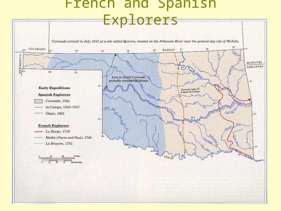
French and Spanish Explorers

Assessment Based on Age
• Early Exploration Period– Deer Creek & Bryson Paddock sites (Kay Co.)
• Early- to mid-1700s (with French trading connection)
– Spanish Fort (historic Wichita village, Jefferson Co.)• Mid-1700s to early-1800s (site attacked by Spanish 1758)
• Removal Period 1820s-1850s– Typically associated with one of the five Civilized
Tribes– Location of site may depend on degree of blood
• Slave owner/plantation oriented versus non-slave owner
– Sites are generally located in eastern Oklahoma

Indian Territory, 1855-1866
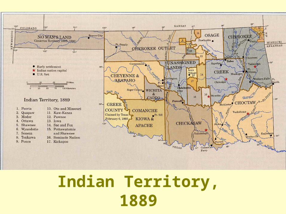
Indian Territory, 1889

Northeastern Oklahoma Tribes

Historic Context: Pre-Statehood Settlement Pattern
• Period 1889-1906– Land Runs– Allotment– Lotteries– Sealed Bids

Land Grab: Anglo-American Settlement Pattern
• Lands Opened by Runs– Unassigned Lands - April 22, 1889– Iowa, Sac & Fox, Pottawatomie & Shawnee -
September 22, 1891– Cheyenne & Arapaho - April 19, 1892– Cherokee Outlet - September 16, 1893– Kickapoo - May 23, 1895

1889-1906 Land Openings

Settlement Pattern cont.
• Lands Opened by Allotment– Tonkawa - 1891 (now Kay County)
– Pawnee - 1892 (now Pawnee County
– Ponca - 1904 (now Kay & Noble counties)
– Oto-Missouri - 1904 (now Noble County)
– Kaw-1906 (now Kay County)
– Osage - 1906 (now Osage County)

Allotments cont. (Five Civilized Tribes)
• Choctaws – 1897• Chickasaws – 1897• Seminoles – 1898• Creeks – 1901• Cherokees – 1902
– No surplus lands available for allotment in eastern Indian Territory
– Land acquired through other means

Settlement Pattern cont.
• Lands Opened by Lottery– Wichita & Caddo - July 9 to August 6, 1901– Comanche, Kiowa and Apache - July 9 to
August 6, 1901
• Lands Opened by Sealed Bids– Big Pasture - December 1906

Proposed State of Sequoyah, 1905

Determining site eligibility: Considerations
• Complexity of site– Single component versus multi-component
• Ethnicity • Period(s) of occupation
– Pre-1890 versus post-1890*
*Post-1890s sites are more common due to large migration into territory as result of runs, lotteries, and purchases of allotments

Integrity and Significance:Both factors in decision
• Integrity:– Presence of features (foundation stones,
water well, depressions denoting possible cellar or cistern, vegetative plantings, etc.)
• Demonstrates farmstead layout (integrity)
Integrity and Significance cont.
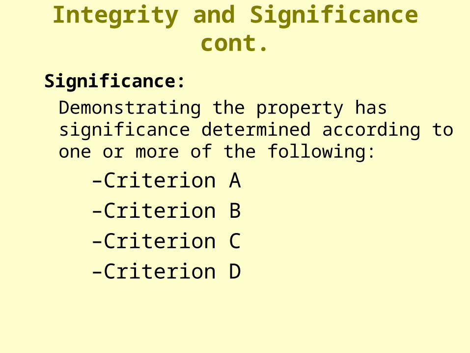
Significance:
Demonstrating the property has significance determined according to one or more of the following:
–Criterion A
–Criterion B
–Criterion C
–Criterion D

Integrity and Significance cont.
• Criterion A: associated with events that have made a significant contribution to the broad patterns of our history
– settlement of a community or important battle field site• Criterion B: associated with the lives of persons
significant in our past– George Guess (aka Geo. Guyst, Geo. Guist, Geo. Gist)
• Criterion C: embody distinctive characteristics of a type, period, or method of construction, or represent a significant and distinguishable entity whose components may lack individual distinction
– brick kiln or charcoal production/operation facility • Criterion D: may yield information important in history
or prehistory – archeological sites

An Example
• Historic Context: Cherokee Settlement Pattern– Camp Gruber: Native American Cherokee versus
Cherokee Freedman
• Defined by allotment records and archeological sites

Early Cherokee Settlement

Cherokee Nation 1889

Case Studies
• Nannie Sleeper allotment, site 34MS404
• John Benge allotment, site 34MS406
• Manard Baptist Church, cemetery & school house, site 34MS407
• Sequoyah’s Cabin
• Eliza Bressman allotment, site 34PT141

Plan Map: Site 34MS404
Nannie Sleeper Allotment

34MS404 Builder’s Trench
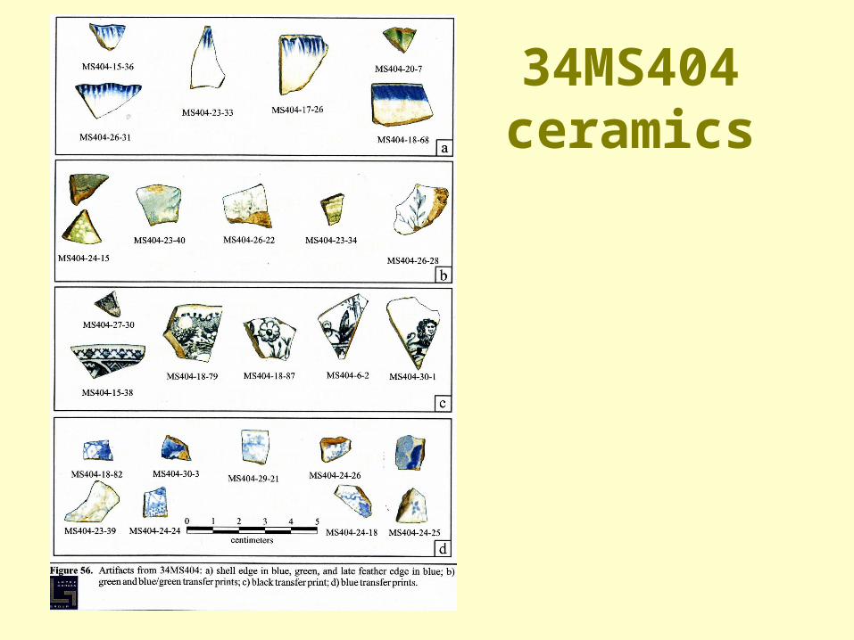
34MS404 ceramics

34MS404 ceramics

Settlement pattern 1896 GLO survey

Circa 1910 Cherokee Nation Township Map

Nannie Sleeper Allotment**although chain of title shown below states site area was
designated as homestead this is incorrect
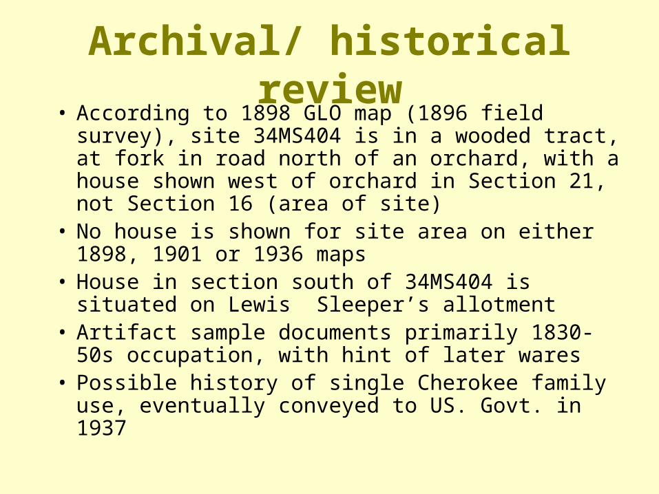
Archival/ historical review• According to 1898 GLO map (1896 field survey),
site 34MS404 is in a wooded tract, at fork in road north of an orchard, with a house shown west of orchard in Section 21, not Section 16 (area of site)
• No house is shown for site area on either 1898, 1901 or 1936 maps
• House in section south of 34MS404 is situated on Lewis Sleeper’s allotment
• Artifact sample documents primarily 1830-50s occupation, with hint of later wares
• Possible history of single Cherokee family use, eventually conveyed to US. Govt. in 1937
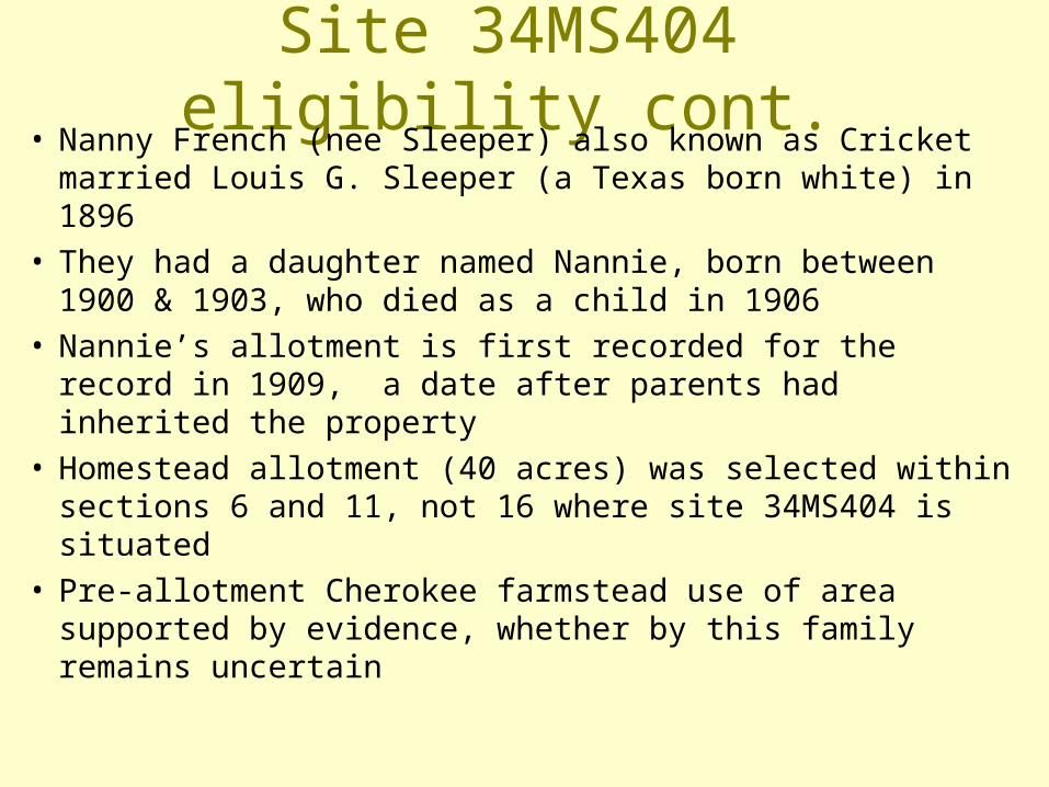
Site 34MS404 eligibility cont.• Nanny French (nee Sleeper) also known as Cricket
married Louis G. Sleeper (a Texas born white) in 1896• They had a daughter named Nannie, born between 1900
& 1903, who died as a child in 1906• Nannie’s allotment is first recorded for the record in
1909, a date after parents had inherited the property• Homestead allotment (40 acres) was selected within
sections 6 and 11, not 16 where site 34MS404 is situated• Pre-allotment Cherokee farmstead use of area supported
by evidence, whether by this family remains uncertain
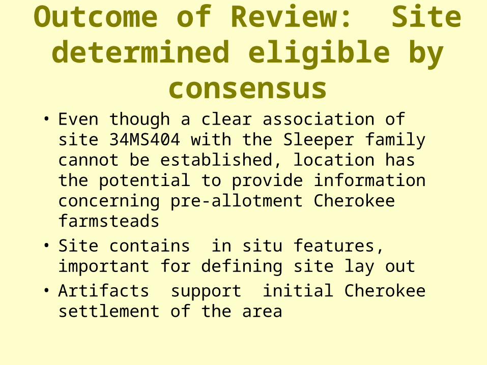
Outcome of Review: Site determined eligible by consensus
• Even though a clear association of site 34MS404 with the Sleeper family cannot be established, location has the potential to provide information concerning pre-allotment Cherokee farmsteads
• Site contains in situ features, important for defining site lay out
• Artifacts support initial Cherokee settlement of the area

John Benge Allotment
Site 34MS406

Site 34MS406 Glasswares

Site 34MS406 Plan Map

Site 34MS406 Chain of Title

Archival/ historical research• John Benge born circa 1889, resided with father Martin
V. Benge who lived in Township east of J. Benge’s allotment (US Census 1900)
• Site 34MS406 on J. Benge 50 acre homestead allotment• J. Benge’s homestead had all restrictions removed in
1921 when property conveyed to Adna Starr Benge, relationship unknown but possibly wife of a brother
• According to 1920 Muskogee County Court records, J. Benge resided with wife and family at Fort Lyon, CO
• Adna Benge a Fort Gibson subscription school teacher, rented a home in Nash Township (US Census 1920), but possibly not area of site 34MS406
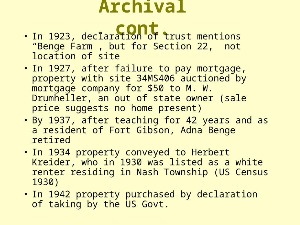
Archival cont.• In 1923, declaration of trust mentions “Benge
Farm”, but for Section 22, not location of site• In 1927, after failure to pay mortgage, property
with site 34MS406 auctioned by mortgage company for $50 to M. W. Drumheller, an out of state owner (sale price suggests no home present)
• By 1937, after teaching for 42 years and as a resident of Fort Gibson, Adna Benge retired
• In 1934 property conveyed to Herbert Kreider, who in 1930 was listed as a white renter residing in Nash Township (US Census 1930)
• In 1942 property purchased by declaration of taking by the US Govt.

Summary of review• No building noted for area, 1896 GLO survey• Chain of title documents multiple owners• Archival data unclear as to date of initial residency • Artifact sample supports early-20th century occupancy• Occupants likely share croppers or renters, not initial
Cherokee allottee• 1941 aerial photo (of poor resolution) appears to still
show two to four buildings in site area

Outcome of review: Site determined not eligible
• Association of site 34MS406 with John Benge may only be through receipt of a homestead allotment for the tract, not actual occupation
• Adna Benge’s occupation of site 34MS406 also not established, possible absentee owner only
• Sharecropper occupation also a possibility• Artifact sample supports 20th Century occupation,
likely later Anglo owner use only

Manard Baptist Church, cemetery
& school house, site 34MS407
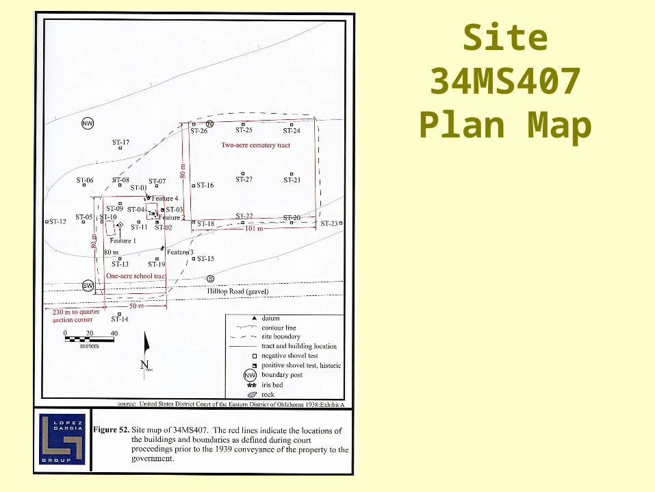
Site 34MS407 Plan Map

Site 34MS407 Chain of Title

Outcome of review: Site determined eligible by consensus
• Documented early church and school use
• Cemetery reflects settlement pattern
• Uncommon site for region, has information potential for addressing post-allotment Cherokee Nation sites other than farmsteads
Questioning documented “History”: Examining the record
• An example:
– Sequoyah’s cabin site, Oklahoma Historical Society property
– Listed on the National Register of Historic Places as a National Historic Landmark (NHL)

Assessment • Site is already listed on the National Register of
Historic Places, assessment already determined• There is however the question, is this the actual
location of Sequoyah’s home? • Was the house moved in from somewhere else in
1936?• Should be verifiable by conducting an
archeological survey of the entire OHS tract

USGS Brushy, Okla. Quadrangle 1973

Government Land Office Survey 1896-1897 (GLO 1898) Section 15, T12N, R25E

Sequoyah cabin versus Geo. Blair cabin
• Relationship of George Blair farmstead to Sequoyah’s cabin
• Sequoyah’s cabin site, Oklahoma Historical Society property as of 1936
• Protective stone covering constructed by WPA in 1936-39 for “Sequoyah home shrine”
• Blair Cabin last occupied in 1960• Tract with George Blair’s cabin, later purchased
and added to OHS property sometime after 1987
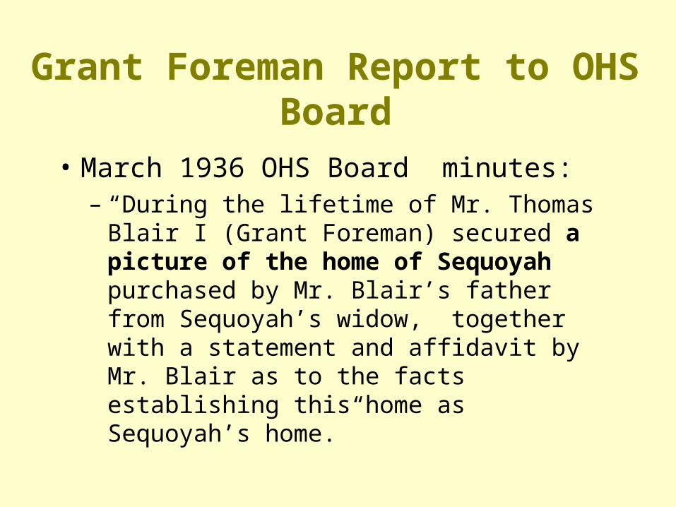
Grant Foreman Report to OHS Board
• March 1936 OHS Board minutes:– “During the lifetime of Mr. Thomas Blair I
(Grant Foreman) secured a picture of the home of Sequoyah purchased by Mr. Blair’s father from Sequoyah’s widow, together with a statement and affidavit by Mr. Blair as to the facts establishing this home as Sequoyah’s home.”


Background• Geo. BlairGeo. Blair born December 16, 1866,
somewhere in the Flint District, Cherokee Nation– appears in the 1880 Cherokee census, age 13, while
living in the Sequoyah District (now Sequoyah Co., Okla.)
– appears in the 1900 Federal census as a farmer in the Cherokee Nation, I.T.
– died 1910, buried in Blair Cemetery across road from cabin site
– allotment stayed in family until property acquired by Oklahoma Historical Society

Background cont.
Sequoyah born cir 1770 in Tennessee– 1823 living among the Western Cherokees in
Arkansas Territory (western Arkansas)– established salt works & blacksmith shop;
resumed trading in the Sequoyah District, cir 1828
– died somewhere in Mexican Territory in 1843 (either northern Mexico or south Texas)

Blair Cabin

Chimney details

Detail of log notching pen 1

Detail of log notching pen 2

What would distinguish one site from another?
• Artifacts should be reflective of specific activities:– Sequoyah noted as having a drinking problem
• Compare quantity/distribution of alcohol related artifacts between sites
– Documented excellent silver smith and iron worker
• Should be indications of these activities at the site
– Including possible forge remains and blacksmith related debris
– Inventor of the Cherokee alphabet • Possibility of lead type with Cherokee letters even though
no history of printing press on site

Assessing National Register of Historic Places eligibility cont.
• Potawatomi settlement pattern– Eliza Bressman farmstead (34PT141)

Potawatomi Nation

Work in progress 34PT141, Feature 34

Feature 34 cistern upper limits
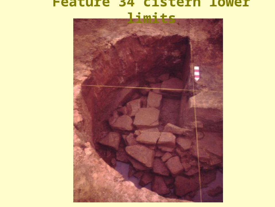
Feature 34 cistern lower limits

Outcome of review: Site determined not eligible
• Occupation of site associated with a single family (mother passed down to daughter), however, late Potawatomi allotment use with tribal member (as well as family) not noted significant in history
• Determined not out of the ordinary farmstead site for the watershed, nor for the county
• Site occupied from 1896 up to 1948, artifact sample mainly associated with mid-20th Century occupancy, not initial 1890s use
Where do we need to go next?
• Consider under-represented contexts – (both chronological and ethnic)
• Very little work has been conducted on pre-reservation era Historic Period sites in Oklahoma
– Suggestions for consideration: » Osage settlements along Grand River &
Three Forks area» Wichita villages, Devil’s Canyon region

Where do we need to go cont.• Also few investigations relating to
Native American, post- reservation era homesteads
– Suggestions for consideration:» Seminole farmsteads (both pre and post-
allotment times)» Apache prisoner of war sites at Fort Sill
• Point of fact: Almost no work has been conducted on post-1889 age homesteads regardless of region or ethnicity

Additional information concerning the evaluation of
Historic Period archeological sites can be found at:
• State Historic Preservation Office’s web site, Fact Sheet #12: “Evaluating Historic Period Archeological Sties for the National Register under Section 106 with Particular Reference to Sites Dating after 1890”

Questions?
If not, thank you