assessing public perception of landscape: the landmap experience
TRANSCRIPT

This article was downloaded by: [University of Birmingham]On: 06 October 2014, At: 03:31Publisher: RoutledgeInforma Ltd Registered in England and Wales Registered Number: 1072954Registered office: Mortimer House, 37-41 Mortimer Street, London W1T3JH, UK
Landscape ResearchPublication details, including instructions forauthors and subscription information:http://www.tandfonline.com/loi/clar20
Assessing Public Perceptionof Landscape: The LANDMAPexperienceAlister ScottPublished online: 19 Aug 2010.
To cite this article: Alister Scott (2002) Assessing Public Perception ofLandscape: The LANDMAP experience, Landscape Research, 27:3, 271-295, DOI:10.1080/01426390220149520
To link to this article: http://dx.doi.org/10.1080/01426390220149520
PLEASE SCROLL DOWN FOR ARTICLE
Taylor & Francis makes every effort to ensure the accuracy of all theinformation (the “Content”) contained in the publications on our platform.However, Taylor & Francis, our agents, and our licensors make norepresentations or warranties whatsoever as to the accuracy, completeness,or suitability for any purpose of the Content. Any opinions and viewsexpressed in this publication are the opinions and views of the authors, andare not the views of or endorsed by Taylor & Francis. The accuracy of theContent should not be relied upon and should be independently verifiedwith primary sources of information. Taylor and Francis shall not be liablefor any losses, actions, claims, proceedings, demands, costs, expenses,damages, and other liabilities whatsoever or howsoever caused arisingdirectly or indirectly in connection with, in relation to or arising out of theuse of the Content.
This article may be used for research, teaching, and private study purposes.Any substantial or systematic reproduction, redistribution, reselling, loan,sub-licensing, systematic supply, or distribution in any form to anyone is

expressly forbidden. Terms & Conditions of access and use can be found athttp://www.tandfonline.com/page/terms-and-conditions
Dow
nloa
ded
by [
Uni
vers
ity o
f B
irm
ingh
am]
at 0
3:31
06
Oct
ober
201
4
Landscape Research, Vol. 27, No. 3, 271–295, 2002
Assessing Public Perception of Landscape: theLANDMAP experience
ALISTER SCOTT
ABSTRACT Assessing public perception of landscape continues to be both an academicand a policy challenge. The involvement of the public in landscape matters has been andcontinues to be both controversial and problematic. Constraints of time and resources,together with a reluctance to delegate responsibility to the public, have generally limitedthe scope and in�uence of much participation to conventional reactive strategies. Thepotential of a new methodology to identify public perception of landscape in Den-bighshire is assessed. Forming part of a wider initiative known as LANDMAP, atechnique adopted by the Countryside Council for Wales for identifying distinctivelandscape areas, household questionnaires and focus groups have been used to evaluatepublic perception in response to carefully selected photographic media. The results affordimportant insights into public perception and allow particular landscape types to beevaluated in both quantitative and qualitative terms. Analysis of the results for twoselected areas shows that the public has strong attachments to managed rural landscapesin general, and wishes to see more integrative and participative strategies for landscapeprotection and management. Such attitudes challenge planners and policy makers torethink their approaches towards conventional landscape management strategies andplanning.
KEY WORDS: LANDMAP, public perception, citizen participation, focus groups,methodology, re-appraisal of planning policy
Introduction
Landscapes do not have edges, they are seamless webs which extendout in all directions, constrained only by the conceptual horizons of thepeople for whom such spaces mean something. (Darvill, 1998, p. 16)
This paper presents a new methodology developed for measuring and mappingpublic perception of landscape in Wales.1 Two fundamental questions posed byAppleton (1975)—what is it we like about landscape and why?—have longpre-occupied academic researchers and provide the main inspiration to the
Alister Scott, Welsh Institute of Rural Studies, University of Wales, Aberystwyth SY23 3AL, UK.Email: [email protected]
0142-6397 Print/1469-9710 Online/02/030271-25 Ó 2002 Landscape Research Group Ltd.DOI: 10.1080/0142639022014952 0
Dow
nloa
ded
by [
Uni
vers
ity o
f B
irm
ingh
am]
at 0
3:31
06
Oct
ober
201
4

272 A. Scott
research reported here. In addition, there is a further question relating to theextent that public perception should in�uence landscape policy.
The principal focus of this paper relates to a pilot study of mapping publicperception in Denbighshire in 1999 (Figure 1; Scott, 1999).2 Forming part ofLANDMAP, a new landscape resource assessment technique devised by theCountryside Council for Wales (CCW), public perception is identi�ed as one ofeight factors contributing to a multi-dimensional assessment of landscape (CCW,1999, 2001).
The paper proceeds with a critical review of factors in�uencing, and pastapproaches to measuring, landscape perception and the allied problem ofsecuring effective public participation. It then considers the methodologicalapproach employed within LANDMAP using two landscape studies from theDenbighshire study to highlight the potential and application of the approach.
Landscape Perception and the Public
Public perception of landscape is playing an increasingly important role incontemporary rural Britain. The psychology of seeing, and attaching value andmeaning, to a landscape in�uences where people choose to live, how and wherethey work, their sense of well being and their sense of place (Appleton, 1996;Countryside Commission, 1993). Perceptions can also in�uence subjective judge-ments at a sub-conscious level, so shaping reactions to, and feelings about,certain landscapes, features or developments. Consequently, the visual appear-ance and perception of our surroundings continue, as in the past, to beimportant (Moore-Colyer, 1999). Certain landscapes are valued for their charac-ter, features and patterns, and people are often resistant to signi�cant changes inthe visual appearance of familiar or local landscapes (Council for the Protectionof Rural England (CPRE), 1999; Gourlay & Slee, 1998; House & Fordham, 1997;Shucksmith et al. 1993). Gold and Burgess quote the pre-occupation with “highculture environments” (1982, p. 2) and question the daily environments that aretaken for granted by policy makers, academics and inhabitants, where thestrength of attachment to ordinary places and landscapes frequently onlyemerges when they are threatened by change. Indeed, familiarity with landscapehas long been an important factor identi�ed in perception studies by Burgess etal. (1988) and Penning-Rowsell (1982). As Tapsell (1995) acknowledges, the mostvalued open areas are often the familiar ones which play a part in people’s dailylives.
Consequently, perception does not depend just on the physical landscapecomponents, but also on the values, past experiences and socio-cultural con-ditioning of the observer (Brabyn, 1996). Landscape responses are thereforeviewed as a product of the interaction of people with the physical and culturalenvironments at particular times (Emmelin, 1996; Muir, 1999). Appleton (1994)speculates that positive responses to landscape are derived from the totality ofthe landscape, and not only from the particular features and elements containedwithin it.
When landscapes change at varying paces according to the relative rate ofland-use change, technological development and the needs of society, a cleartension is created between differing sectors of the public that value particularlandscapes. The relationship between perception and participation is complexand brings into consideration issues of equity, accountability and democracy,
Dow
nloa
ded
by [
Uni
vers
ity o
f B
irm
ingh
am]
at 0
3:31
06
Oct
ober
201
4

Assessing Public Perception of Landscape 273
Table 1. Some key factors affecting public perception of landscape
Factor Authors (illustrative references only)
Biological origins, sense of place Appleton (1990)Cultural associations Hull & Revell (1995); Gold (1980)Age Bernaldez et al. (1995)Naturalness Hodgson & Thayer (1980)Familiarity Wellman & Buhyhoff (1980)Perceived landscape value Countryside Council for Wales (1996)Feelings evoked Moore-Colyer (1999)Sound and smell Bullen et al. (1998a, 1998b, 1999)Viewer’s background Brabyn (1996); Hitchmough & Bonugli (1997)
and questions the way that the wider public interest is represented and imple-mented in landscape management terms.
The town and country planning system is the principal mechanism invokedto address and resolve such matters, balancing the sometimes competing viewsand needs of private individuals with the wider public interest (Cullingworth &Nadin, 2001). Since perception of the landscape is an important component ofplanning practice and policy, it is important to understand the multiple factorsshaping that perception (Table 1).
The CCW captures the essence of the multi-dimensional nature of landscapewithin the following summary:
Landscape may be thought of as the environment perceived predomi-nantly visually but also with all the other senses. Sight, smell andsound all contribute to landscape appreciation. Our experience oflandscape is also affected by cultural background and personal andprofessional interests. For CCW’s purposes landscape is de�ned as thesum of all these components. (CCW, 1999, Appendix 1, p. 4)
Clearly, public perception is complex and idiosyncratic, rendering simple analy-sis or generalization problematic. The resulting variability and subjectivityarising from human responses to particular ‘landscapes’, therefore, are bothelusive and conditional. Indeed, research has demonstrated that people canexhibit different perceptions of the same landscape (Brabyn, 1996). These�ndings lend support to those who argue that such views are incapable ofmeaningful interpretation and are often cited as reasons why the public shouldnot be directly involved in landscape matters (Nicholls & Sclater, 1993). Thisreluctance is not just con�ned to practitioners, but is also evident in theacademic literature, where various commentators have argued for a profession-ally led approach, relying on those trained in design to express judgements ofscenic quality in order to interpret the aesthetic values of society in a consistentmanner (Jacques, 1980; Kaplan & Kaplan, 1982, Chapter 4; University ofManchester, 1976; Sanoff, 1991).
This genre of landscape studies, evident in the work of Linton (1968), Crofts(1975) and the CCW (1999), has essentially involved a multivariate and spatialtype analysis. The most striking example is found in the work of the Coventry–Solihull–Warwickshire Sub-Regional Planning Group (1971), which identi�edthree factors as principal determinants of a landscape’s value (land-
Dow
nloa
ded
by [
Uni
vers
ity o
f B
irm
ingh
am]
at 0
3:31
06
Oct
ober
201
4
274 A. Scott
form, land use and land features). The subsequent creation of maps usingcalculated indices of landscape value and inter-visibility produced an expert-ledand so-called ‘objective’ measure of landscape value. Studies of this type haveattracted considerable academic debate and criticism, primarily relating to theaggregation of synthetic landscapes from pre-selected components and from thebiases inherent in the values and preferences of experts involved in subjectiveassessments in the �eld (Duf�eld & Coppock, 1975; Gold, 1980). Appleton (1994)presents a powerful polemic against the use of such techniques where, inparticular, the 1975 Manchester Landscape Evaluation Research Project isshown as an example of the extent to which subjective and relatively arbitraryassumptions are built into the system. Similarly, Kaplan (quoted in Nasar, 1988)noted that although experts are invaluable when used appropriately, they areunreliable as objective judges of what people care about in the landscape.
Consequently, a number of authors have endorsed the value of publicperception and preference approaches, particularly as it is the public who willultimately experience the developments in question (Kent, 1993; Penning-Rowsell, 1982; Seddon, 1986). In a similar vein, House & Fordham (1997) warnagainst the danger of bypassing the views of the ‘ordinary person’. In 1976,research carried out by the US Department of Agriculture highlighted theimportance of listening to the perceptions of the public when a Forest ServiceNational Recreation Strategy was being formulated. Henson (1990) argued thatit was the people, not the framework, that were the vital element of theprogramme.
Today there is a growing, if seemingly reluctant, recognition among de-cision makers and affected parties addressing landscape problems that tra-ditional top-down strategies are insuf�cient. Expert-led approaches can readilybypass local and anecdotal knowledge of places and circumstances and riskproducing outcomes that are incompetent, irrelevant or unworkable (Roberts,1998). Consequently, a more citizen-led philosophy has been widely promul-gated within a new rhetoric of empowerment and local action, strongly associ-ated with the advent of Agenda 21 strategies and their corresponding LocalAgenda 21 plans (Edwards, 1998). This ‘bottom-up’ approach has been charac-terized by a range of responses and initiatives aimed at improving locallandscapes and quality of life. Parish maps celebrate local identity and distinc-tiveness using a variety of visual forms (Clifford & King, 1993; Crouch &Matless, 1996; Greeves, 1987), whilst village appraisals have led to a range oflandscape and other community improvements (Francis & Henderson, 1992;Greeves & Taylor, 1987). More recently, village design statements have emergedas powerful supplementary planning tools (Owen, 1999).
Notwithstanding these advances, assessing public perception per se contin-ues to be a problematic task. Studies of perception by Burgess et al. (1988) andLee (1982) and the landscape assessment studies of Fines (1968), Penning-Rowsell (1981, 1989) and Penning-Rowsell & Hardy (1973), in particular, high-light the dif�culties in ascertaining meaningful interpretations of landscapes andpublic perception. Similarly, in work by Lee (1990) on perception of forestrylandscapes, the principal dif�culty occurred with the measurement and transfer-ence of preference into landscape planning policies.
Although the academic contribution has undergone signi�cant evolutionand re�nement, partly as a result of the problems identi�ed above, it has yet toproduce a universally accepted approach. Pioneering quantitative-basedmethodologies are evident in the work of Penning-Rowsell (1974) with semantic
Dow
nloa
ded
by [
Uni
vers
ity o
f B
irm
ingh
am]
at 0
3:31
06
Oct
ober
201
4

Assessing Public Perception of Landscape 275
rating scales in the Wye Valley Area of Outstanding Natural Beauty (AONB)and Shafer and Brush’s (1977) research into utilizing photographs in public-perception research. Byrne (1979) also used photographs in conjunction with aquestionnaire in order to assess public perception of Land’s End Peninsula,where it was felt that such surveys had the potential to be a useful tool inlandscape appraisal and development control matters. Signi�cantly, Dunn’swork helped to con�rm the validity of substituting photographs as a means ofidentifying landscape perception (Dunn, 1976). However, Rieser (1972) sounds anote of caution in the use of photographs as landscape surrogates with theiremphasis on the visual component and their overall subjectivity. More recently,approaches have utilized new technologies where Internet and geographicalinformation system (GIS) applications have �ourished (Brabyn, 1996; Wherrett,2000). An interesting project for virtual decision incorporating Planning for Realwith Internet applications has been developed for the village of Slaithwaite atLeeds University (Kingston et al., 1999). Despite all these developments, theireffective translation into policy still seems elusive. Nevertheless, some interest-ing work is evident in the use of scenario-based studies, where the publicrespond to a series of visual representations of possible future landscapes in amore proactive and policy-oriented process (Tress & Tress, 2000; Yorkshire DalesNational Park, 1992).
Such dif�culties have resulted in a signi�cant shift towards more experien-tial research utilizing more qualitative-based methodologies where, in particular,the use of focus groups has mushroomed in applied landscape research(Burgess, 1996). Indeed, pioneering work by Burgess on fear in communitywoodlands demonstrated the value of focus groups which provided a valuablediscourse on a subject when time for �eld research was constrained and policyrecommendations were needed quickly by decision makers (Burgess, 1996;Burgess et al., 1988). Furthermore, small-group discourse allows debate, argu-ment and values to come to the fore, thereby supplementing the more estab-lished quantitative methods of enquiry (Burgess, 1999; Penning-Rowsell, 1982).However, Burgess, while advocating qualitative methodologies, felt it crucial toback up these studies with quantitative evidence. Indeed, this partnershipapproach is central to the methodological development of the present study.
Public Perception and LANDMAP
The research on public perception reported here forms a constituent part of theLANDMAP approach in Wales. This is an expert-led technique for landscaperesource assessment which identi�es and maps landscape according to a rangeof combined criteria (Figure 1). The process was introduced and devised by theCCW and the Welsh Landscape Partnership Group in 1996 (CCW, 1999, 2001).3
LANDMAP uses a multivariate approach to landscape based on compositegeographical areas, known as ‘landscape character areas’. These are based onseven factors, which produce 12 separate layers of information, as follows:
· geology and geomorphology (three layers)· visual, sensory and spiritual (one layer)· biodiversity (one layer)· historic (one layer)· cultural associations (two layers)
Dow
nloa
ded
by [
Uni
vers
ity o
f B
irm
ingh
am]
at 0
3:31
06
Oct
ober
201
4

276 A. Scott
Figure 1. The stages of LANDMAP identifying the public-perception aspect.
· settlement and development (one layer)· rural land use (three layers).
The last two are included as contextual information only, to provide additionalinsight for decision makers, and not for the identi�cation of character areas.
Each character area is identi�ed and evaluated by nominated ‘experts’ whowork to set templates provided by the LANDMAP advisory service (Parker,2000, pers. comm.; Figures 2, 3). Figure 2 shows a screen capture from the centraldatabase for a composite character area. These screens are built up from thesuperimposition of different layers of information in the process incorporatingcontextual information and evaluative aspects. The example shown in Figure 3,Biodiversity, is an example of an evaluated aspect, whereas Rural land use andSettlement form only descriptive aspects (for contextual purposes).
Through this combined approach, LANDMAP sets out to bring together themany facets of landscape into a single, multi-purpose assessment that surpasses
Dow
nloa
ded
by [
Uni
vers
ity o
f B
irm
ingh
am]
at 0
3:31
06
Oct
ober
201
4

Assessing Public Perception of Landscape 277
Figure 2. Screen capture of the character area. Source: Parker (2000).
simple visual assessment. LANDMAP’s �exibility in integrating the variouslayers of information through GIS and remote sensing applications has thepotential to allow informed decisions to be made at a variety of scales. Such anapproach has a major role in in�uencing the content of landscape plans andproviding a spatial framework for local planning matters. Indeed, LANDMAPis now the favoured approach to landscape assessment throughout localauthorities in Wales and has been favourably received by planning inspectors atpublic inquiry, particularly in the development of local authority manageddesignations (Special Landscape Areas).
The public-perception aspect, whilst not a ‘character area’ as such, has beenincorporated into the overall methodology (Figure 1). The responsibility fordevising the methodology lay with the present author, in conjunction with otherstaff at the Welsh Institute of Rural Studies.4
Methodology
The study in Denbighshire (Figure 4) was the �rst to involve this overallmethodological stance. A key requirement would be to provide some summarypublic-perception data to accord with the template and GIS applications ofcharacter areas as illustrated in Figure 2.5 Given that public-perception researchoccurs towards the end of the LANDMAP process after the composite characterareas have been identi�ed and mapped (Figure 5), the experts critically shapeand in�uence the process. This compromise is important, as the public percep-
Dow
nloa
ded
by [
Uni
vers
ity o
f B
irm
ingh
am]
at 0
3:31
06
Oct
ober
201
4

278 A. Scott
Figure 3. Screen capture of the biodiversity template. Source: Parker (2000).
tion is operationalized within the boundaries and technical knowledge ofprofessionals. This top-down approach is seen as necessary given the nature ofthe exercise, but it does condition and generalize perception to �t in with‘expert’ notions of character areas. This is both its strength and its potentialweakness: strength because it focuses the public on certain landscapes; weaknessbecause it constrains the comments to constructed landscapes rather than locallandscapes and concerns. This has been addressed, in part, in the handbook,with the development of a more ambitious, long-term bottom-up methodology(CCW, 2001).
A combination methodology was adopted in the present study, utilizingboth conventional household questionnaires and focus groups following therecommendations of Lee (1990) and Burgess (1996). The principal objects focusedon by the public-perception study were the photographic media, and theresearchers sought to select images which were more representative than hadbeen the case in previous studies.6
The LANDMAP process in Denbighshire resulted in the identi�cation of 10‘landscape character’ areas (Rees, Principal Countryside Of�cer, DenbighshireCountryside Service, 1999, pers. comm.; Figures 5, 6). The strategy employedwas to select three ‘representative’ landscape photographs from within each ofthese areas to be used for the study. The Principal Countryside Of�cer took alarge number of photographs from each area, during a three-week period. Theuse of a ‘local expert’ was critical in attempting to obtain the best representationof photographs; to minimize bias all photographs were taken in similar light andweather conditions and were devoid of people. The �nal choice of photographs
Dow
nloa
ded
by [
Uni
vers
ity o
f B
irm
ingh
am]
at 0
3:31
06
Oct
ober
201
4

Assessing Public Perception of Landscape 279
Figure 4. Location of Denbighshire.
Figure 5. Landscape character types from Den-bighshire LANDMAP (adapted).
was then decided by a team involving the public-perception consultants and theDenbighshire Countryside Service.7 However, there is a problem in reconcilingthe multi-dimensional assessment of landscape as employed by the experts indevising the character areas with the mono-dimensional response obtained fromthe public responding to the photographs, where the visual component clearlydominates the assessment. Methodologically, however, given the constraints oftime and resources, there seemed little alternative to this approach.
The following question areas pertaining to each of the 10 ‘landscapes’ weresystematically addressed in the household questionnaires and focus groups:
· landscape appreciation (likes and dislikes) with justi�cation· features important to conserve with justi�cation· features important to change/enhance with justi�cation.
‘Open’ questions were used throughout so as not to pre-judge responses. Thesewere later coded for tabular display from the questionnaire or subjected todiscourse analysis for the focus groups.
Respondents employed in the household questionnaire were chosen atrandom from the electoral register. The reliability of the sample was improvedby selecting respondents from speci�c ward clusters according to variouseconomic, social and rural/urban factors (Figure 7; Of�ce for National Statistics,1991). In addition, the sample was strati�ed by age and gender statistics. This
Dow
nloa
ded
by [
Uni
vers
ity o
f B
irm
ingh
am]
at 0
3:31
06
Oct
ober
201
4

280 A. Scott
Figu
re6.
Phot
ogra
phic
mat
eria
lus
edin
publ
icpe
rcep
tion
stud
y.
Dow
nloa
ded
by [
Uni
vers
ity o
f B
irm
ingh
am]
at 0
3:31
06
Oct
ober
201
4

Assessing Public Perception of Landscape 281
Figure 7. Diagram to show methodological adaptation of ONS ward study for Denbighshire. Source:ONS (1991).
modi�cation of the sample was critical given the relatively small sample sizewithin the study area (100 respondents).
The results from six focus groups provided the qualitative material tocomplement the data collected from the household questionnaire. Crucially, itallowed the views of groups in the community not normally elicited in conven-tional survey approaches to be identi�ed and explained, as well as facilitating amore detailed discourse into people’s attitudes and feelings towards locallandscapes (Gibbs, 2001; Scott & Jones, 1998).
A facilitator was used for all sessions, which were taped to enable tran-scripts to be made of the interviews. Welsh or English was used as dictated bythe groups’ wishes. The groups used in the research were as follows:
· Children· Youth (aged 13–17)· Special Needs· Unemployed· Visitors· Rural Land Use.
Selection was based on a purposive approach, adapting the stakeholder group-ings identi�ed by the former Local Government Management Board (1994) forLocal Agenda 21 plans. Normally groups were constructed by targeting appro-priate organizations—a primary school for ‘Children’, a youth club for ‘Youth’and so on. No attempt was made to be representative, as that was the preserveof the household questionnaire. Exceptions to this method included the com-posite Rural Land Use and Visitor groups, which demanded a more individualapproach to secure the necessary 9–12 participants.8
Results and Mapping
Once the survey results and focus-group responses were coded and analysed, itwas possible to build a general picture of public perceptions to particular
Dow
nloa
ded
by [
Uni
vers
ity o
f B
irm
ingh
am]
at 0
3:31
06
Oct
ober
201
4

282 A. Scott
Figure 8. Screen capture of a household survey response.
landscape types (Figures 8, 9).9 The data were then transferred into a MicrosoftAccess database for incorporation and use within other aspects of theLANDMAP process. In this way, public perception forms an integral part ofLANDMAP and the results form one layer of information in the resultant GIS
Figure 9. Screen capture of a focus-group response.
Dow
nloa
ded
by [
Uni
vers
ity o
f B
irm
ingh
am]
at 0
3:31
06
Oct
ober
201
4
Assessing Public Perception of Landscape 283
application. These results may potentially feed into future landscape manage-ment policies such as the All Wales Agri-Environmental Scheme (Tir Gofal) andUnitary Development Plans (UDPs), both of which utilize GIS applications. Forthe �rst time, it will be possible to incorporate detailed public-perception datainto landscape management proposals. The emphasis, however, lies with thepolicy maker, but there does seem a readiness to present material from thepublic-perception study as supplementary planning guidance for the UDPprocess.
Application of the Methodology in Practice
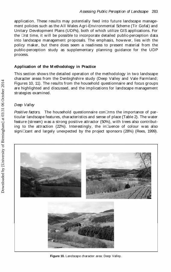
This section shows the detailed operation of the methodology in two landscapecharacter areas from the Denbighshire study (Deep Valley and Vale Farmland;Figures 10, 11). The results from the household questionnaire and focus groupsare highlighted and discussed, and the implications for landscape managementstrategies examined.
Deep Valley
Positive factors. The household questionnaire con�rms the importance of par-ticular landscape features, characteristics and sense of place (Table 2). The waterfeature (stream) was a strong positive attractor (50%), with trees also contribut-ing to the attraction (22%). Interestingly, the in�uence of colour was alsosigni�cant and largely unexpected by the project sponsors (28%) (Rees, 1999).
Figure 10. Landscape character area: Deep Valley.
Dow
nloa
ded
by [
Uni
vers
ity o
f B
irm
ingh
am]
at 0
3:31
06
Oct
ober
201
4

284 A. Scott
Figure 11. Landscape character area: Vale Farmland.
Table 2. Deep Valley: positive factors: percent-ages valuing a particular aspect, and reasons
why aspects were deemed to be valuable
Feature % Why %
Streams 50 Beauty 46Everything 28 Natural 29Colours 28 Inviting 17Trees 22 Managed 11Hills/mountains 9 Personal preference 9Views 9 Variety 6Open spaces 5 Peaceful 4
Source: adapted from Scott (1999).
However, 28% of the responses also referred to the value of the ‘overalllandscape’. The reasons for this high positive assessment focus primarily on theperceived beauty of the scene (46%) and its naturalness (29%). Signi�cantly, thislandscape attracted the highest individual rating for beauty across the 10landscapes. Other attributes such as ‘inviting’ (17%) and ‘managed’ (11%) werealso evident.
The focus-group responses help explain and contextualize the strong attrac-tion to this landscape. Most contributions support the contention that this
Dow
nloa
ded
by [
Uni
vers
ity o
f B
irm
ingh
am]
at 0
3:31
06
Oct
ober
201
4

Assessing Public Perception of Landscape 285
Table 3. Deep Valley: negative factors:percentages identifying aspects as detract-ing from landscape quality, and reasons for
detraction
Feature % Why %
Nothing 61 Discordant 10Conifers 8 Personal preference 5Open spaces 5 Managed 5Trees 3 Arti�cial 2
Source: adapted from Scott (1999).
landscape is valued holistically, rather than based on the contribution of individ-ual factors. Landscape complexity and diversity condition positive responses,with the interplay of landform, topography and colour acting as contributoryfactors.
There’s so much more in the landscape. (Youth)
Like it because it’s got everything; sheep, trees and mountains …because of the colours and the stream. (Children)
Plenty of colours and lows and high, lots of trees and would like towalk in that landscape. The diversity is important. (Visitor)
The more managed aspect to the countryside was also recognized and appreci-ated.
It’s obviously not rough and tumble; it’s tidy, that’s how the country-side should be. (Special Needs)
Negative factors. The high positive assessment for this landscape is reinforcedby the muted pro�le of negative responses (Table 3). In total 61% of respondentsregistered no dislikes. Minor criticisms related to the trees, together comprising11%. The principal reasons for this was the antipathy towards conifers whichcreated discord in the landscape (10%).
The focus-group responses exhibit a similar pro�le, with few negativecomments recorded. The visitor-group comment encapsulates the main sourceof criticism relating to the management of woodland and the unwelcomeintroduction of alien species.
A bit overcontrolled. Trees look like they have been plonked in a veryunnatural way. (Visitor)
Landscape conservation and change. Given the high positive rating afforded tothis landscape it was not surprising that it was seen as important to conserve thelandscape in its entirety (48%) (see Table 4). Particular features also meritedspecial attention, re�ecting the importance of water features (33%) and trees inthis landscape (14%), as previously identi�ed.
Changes to the landscape were not deemed particularly necessary, with themajority of responses advocating the status quo. Changes deemed desirable
Dow
nloa
ded
by [
Uni
vers
ity o
f B
irm
ingh
am]
at 0
3:31
06
Oct
ober
201
4

286 A. Scott
Table 4. Deep Valley: landscape conservationand change
Conserve % Change %
Everything 48 Nothing 46Streams 33 Conifers to deciduous 10Trees 14 Management techniques 5Wildlife 3 Old farm buildings 3
Source: adapted from Scott (1999).
related primarily to modifying the balance between conifers and deciduoustrees, placing greater emphasis on deciduous trees (10%).
Within the focus groups, the conservation message clearly supported whole-sale conservation of the entire landscape.
The present ownership is doing a good job; leave them alone. (RuralLand Use)
In terms of changes desired, the only signi�cant comments related to morecountryside furniture (Youth and Special Needs) and removal of conifers(Unemployed and Visitor).
It’s all very well for active people but is there any way for disabledpeople to access this landscape? (Special Needs)
I do not like the way these alien conifers dominate the scene; they lookout of place. (Visitor)
Vale Farmland
Positive factors. This landscape elicits a range of positive responses from thehousehold questionnaire (Table 5). These tend to revolve around the inherentqualities of a predominantly rural and agricultural landscape where, in particu-lar, the �eld pattern is highly in�uential. As with the previous landscape, theimpact of colours is also highly signi�cant. Reasons for the positive assessment
Table 5. Vale Farmland: positive factors:percentage valuing a particular aspect andreasons why aspects were deemed to be
valuable
Feature % Why %
Farmland 20 Beauty 25Colours 18 Natural 15Settlement 15 Managed 13Fields 15 Inviting 12Everything 13 Personal preference 8Views 12 Busy 3Field pattern 11 Variety 3Open spaces 10 Distinctive 3New houses 8 Diversity 3
Source: adapted from Scott (1999).
Dow
nloa
ded
by [
Uni
vers
ity o
f B
irm
ingh
am]
at 0
3:31
06
Oct
ober
201
4

Assessing Public Perception of Landscape 287
re�ect the perceived beauty (25%) and ‘naturalness’ (15%) of the scene; manage-ment of the agricultural land also featured (13%). It is also signi�cant to recordthat 12% of responses found this landscape inviting, re�ecting a desire activelyto engage with the landscape.
The focus-group responses accord with the household survey results. Theproductive and fertile farmland of Denbighshire elicited a strong positiveresponse, re�ecting the high regard felt by the public for agricultural landscapesin terms of both their productive and their aesthetic potential.
Boring when you look at it from a distance but good when you areactually in it and see the crops growing. (Unemployed)
Looks like a giant chess board. Like a patchwork. I like the pattern andcolours. (Children)
Someone has been working very hard there. (Visitor)
The impact of landform on the area, with the contrast between the plain andadjoining hills, also contributes to the positive scene. In addition, the uniquevalue of the landscape is recognized as important.
The lovely red soil of the vale has a beauty all of its own. That redcolour is different from elsewhere in Denbighshire. (Rural Land Use)
The contrast between this and the slopes that gives it such great appeal.It would be different if this was just a ten mile plain. (Rural Land Use)
It was interesting to note the very strong set of positive responses from the focusgroups. Consistently, responses praised the harmonious relationship betweenfarming and the landscape and how farming was of primary importance in therural economy of Denbighshire.
Farming is very important here. This is a natural landscape. I think weare spoilt living in this area. (Special Needs)
Negative factors. The predominantly positive assessment is reinforced by thelack of criticism relating to the landscape (31%) (see Table 6). Concern wasevident, however, over the potential threats that could manifest themselvesin the landscape. For example, new houses (21%) and the encroachment ofurban in�uences on the landscape were seen as important (12%). Clearly, this
Table 6. Vale Farmland: negative factors: percent-ages identifying aspects as detracting from land-
scape quality, and reasons for detracting
Feature % Why %
Nothing 31 Cluttered 11New houses 21 Personal preference 9Urban 12 Ugly 9Field pattern 5 Arti�cial 8Fields 5 Managed 7Management techniques 3 Large scale 4Old farm buildings 3 Spoilt 4
Source: adapted from Scott (1999).
Dow
nloa
ded
by [
Uni
vers
ity o
f B
irm
ingh
am]
at 0
3:31
06
Oct
ober
201
4

288 A. Scott
landscape was perceived as one under threat of development, althoughsigni�cant new development was not in evidence in the photographs. Thissuggests that the landscape provoked a response based on associated negativepersonal experiences in similar landscapes elsewhere in the county, which wascon�rmed in the subsequent discussion.
Other, more minor criticisms related to the perception that the landscapewas cluttered (11%), personal distaste (9%), ugliness (9%) and arti�ciality (8%).
Within the focus groups too, there was a similarly low number of negativecomments. However, there were some neutral responses that recognized farm-land as a functional, but not particularly attractive landscape. A few commentswent beyond this, focusing around the rather dull and uninspiring aspect to thelandscape (Youth, Visitor, Unemployed).
It’s ok but does not really affect me in any way. (Visitor)
The land has to be worked but it hardly can be described as beautiful.(Unemployed)
You can’t make an intensively farmed landscape turn me on. (Youth)
Landscape conservation and change. The responses for landscape conservationcon�rm the value afforded to this farmed landscape, with one-�fth of respon-dents wanting ‘everything’ to be conserved (Table 7). Speci�c features high-lighted were the �elds (18%), farmland (15%), rural settlement (14%), trees (13%)and hedgerows (10%).
In terms of change, there was a general reluctance to intervene, with 24%wanting no changes. The principal change advocated involved the settlementpattern: a decline in density and curtailment of the urban in�uences on whatwas an essentially rural landscape.
The focus-group responses produced a clear consensus on the importance ofprotecting farmland and agricultural landscapes as a whole. Signi�cantly, therewere no comments opposing this view, even from the Youth and Children!
Farming; it is important to protect us not just the wildlife. (Rural LandUse)
The agricultural landscape is in need of protection, it may not beattractive but it provides us with us food. Let us not forget this.(Unemployed)
Table 7. Vale Farmland: landscape conservationand change
Conserve % Change %
Everything 20 Nothing 24Fields 18 Settlement pattern 18Farmland 15 Urban threat 9Rural settlement 14 Management techniques 8Trees 13 Don’t know 7Hedgerows 10 New houses 3New houses 5 Small scale 2Natural 5 Trees 2Rural 4 Rural 2Open spaces 4 Old farm buildings 2
Source: adapted from Scott (1999).
Dow
nloa
ded
by [
Uni
vers
ity o
f B
irm
ingh
am]
at 0
3:31
06
Oct
ober
201
4

Assessing Public Perception of Landscape 289
You cannot split this up into features; you must conserve it all or loseits character. (Special Needs)
Similarly, across all groups, there was general resistance to landscape changeand improvement, albeit with one crucial exception. Comments from the Visitorgroup suggested the need for more hedges to help break up the impact of thelarger ploughed �elds, while the Rural Land Use group did not want to precludethe need for more ‘balanced’ development in the landscape. This typi�es theclassic tension apparent in contemporary rural perceptions.
We cannot keep places in a time warp. The future of rural areasdepends on the people who live and work in them. (Rural Land Use)
Keep it as it is. It is so beautiful; this is our heritage; do not spoil it bydevelopment. (Special Needs)
Interpreting the Public Perceptions
Nobody ever listens to what we say anyway. (Special Needs)
The household survey and focus groups showed a remarkable and surprisingdegree of convergence in the views expressed and, in so doing, afford acomprehensive and valuable insight into understanding the value of the twolandscape types. Whereas Appleton (1975) sought answers to his questions fromJohn Dewey and the writings of 18th-century philosophers, the Denbighshirestudy allows a contemporary consumer-led response.
The ‘Deep Valley’ and ‘Vale Farmland’ landscape examples highlight thepositive role that diversity, contrast and colour play in landscape appreciation.Indeed, such complexity and contrasts within landscapes match Appleton’spostulations for the highest-order landscapes. They also support Brabyn’s (1996)contention that the interaction of components is more important than thecomponents themselves. While speci�c landscape features such as the streamand the intimate pattern of farm �elds are also positively evaluated, thefocus-group responses reveal that people see the landscape as a whole; theyrarely dissect the landscape into its constituent parts and features, as do policymakers and professionals.
In terms of seeking an explanation of why these landscapes are liked,‘beauty’, ‘naturalness’, ‘inviting’ and ‘managed’ are the terms most commonlyencountered within the questionnaire. There appears to be an element ofcontradiction here in the expression of ‘naturalness’ and ‘managed’ for the samelandscape. Appleton (1994) notes a similar use of terms and views it as a‘meaningless cliche’. Nevertheless, these results have featured in many otherpublic-perception studies across Wales (Bullen et al., 1998a, 1999) and suggestcloser inspection of what is actually meant in contemporary terms by the term‘natural’. It is postulated by the author that it is signi�cant and laden withsymbolism, requiring professionals to adopt a more liberal interpretation of theterm towards a more idyllic vision on behalf of the respondents; i.e. how natureshould be, which does not con�ict with ‘managed’ (Scott, 1999). The use of theterm ‘beauty’ is seen as complementary to this sentiment. It is not coincidentalthat the terms are generally used together in the household survey responses.The positive statement alluding to a ‘tidy landscape … that is as it should be’
Dow
nloa
ded
by [
Uni
vers
ity o
f B
irm
ingh
am]
at 0
3:31
06
Oct
ober
201
4

290 A. Scott
(Special Needs) further develops this idyllic theme. The prevalence of the term‘inviting’ adds a further dimension to perception, suggesting that responses tovalued landscapes are more than just aesthetic; people want to interact with thelandscape in a more direct and explicit manner. This raises the importance ofaccessibility to particular landscapes and its correlation with positive value,introducing a new factor of landscape intercourse.
The ‘management’ response is also important and serves notice that peopleappreciate the way farmers and landowners manage landscapes. Indeed, theresults show a strong predilection towards agriculture, both in terms of land-scape aesthetics and in terms of its economic function in the landscape toproduce food. Again, this was an unexpected result, yet one which was alsoobtained in six other perception studies undertaken in Wales. The expressedcomments and prevalence for a tidy and managed landscape may not equatewith conservation objectives, particularly for biodiversity, where areas perceivedas neglected and overgrown are less valued (Scott, 1999).
The results show a real antipathy towards new or alien developments, evenwhen they are merely potential threats to the landscape, as typi�ed in the ValeFarmland landscape example. Here, the depicted landscape triggered a responseto personal experiences involving the loss of valued landscape. Moreover, suchperceptions are nothing new. Moore-Colyer’s (1999) illuminating paper on theurban–rural divide in inter-war Britain contains many parallels with the �ndingsof this research. He documents the public outcry surrounding new develop-ments in the countryside where both the quantity and quality of buildings werecriticized. Citing A.G. Street, he states there are “Hideous rows of glaring slums,of �aring red, unlovely grey and sickly repulsive ochre” (p. 106), a comment notout of place with the results from the concerns over the Vale Farmlandlandscape. The Deep Valley example shows signi�cant concern over conifers inthe landscape, again with strong symbolism attached to the introduction ofsomething alien or new. More speci�cally, the straight-line geometry anddarkness of conifers are seen as out of place in a landscape which is morenaturally associated with random features.
The Value of the Mapping Methodology
The methodology presented in this paper effects a direct relationship betweenthe components that make up a landscape assessment in the LANDMAP processand public perception in a relatively new and innovative way. As far as thepublic-perception study is concerned, the landscape professionals are intimatelyand exclusively involved in formulating information about, and evaluations of,the seven aspect areas into 12 layers of mapped information. These differentlayers are then generalized into a composite landscape classi�cation of ‘characterareas’, which form the basis of the public-perception study. However, subjectivejudgements are required to select photographs as accurate representations ofthese areas. Rieser’s (1972) concerns regarding photographic selection areequally valid here. However, there is a distinct process shaping the identi�cationof character areas within which photographs are selected that increases theoverall validity and rigour, albeit within the constraints of an essentially visualcomponent.
A signi�cant weakness in this largely reactive technique is exposed in theinability of people to appreciate what kind of change in the landscape might be
Dow
nloa
ded
by [
Uni
vers
ity o
f B
irm
ingh
am]
at 0
3:31
06
Oct
ober
201
4
Assessing Public Perception of Landscape 291
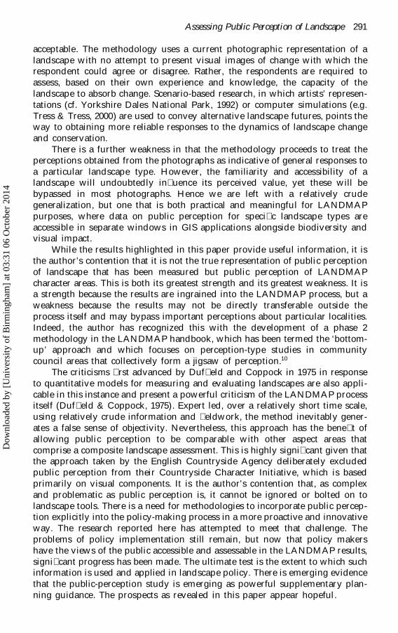
acceptable. The methodology uses a current photographic representation of alandscape with no attempt to present visual images of change with which therespondent could agree or disagree. Rather, the respondents are required toassess, based on their own experience and knowledge, the capacity of thelandscape to absorb change. Scenario-based research, in which artists’ represen-tations (cf. Yorkshire Dales National Park, 1992) or computer simulations (e.g.Tress & Tress, 2000) are used to convey alternative landscape futures, points theway to obtaining more reliable responses to the dynamics of landscape changeand conservation.
There is a further weakness in that the methodology proceeds to treat theperceptions obtained from the photographs as indicative of general responses toa particular landscape type. However, the familiarity and accessibility of alandscape will undoubtedly in�uence its perceived value, yet these will bebypassed in most photographs. Hence we are left with a relatively crudegeneralization, but one that is both practical and meaningful for LANDMAPpurposes, where data on public perception for speci�c landscape types areaccessible in separate windows in GIS applications alongside biodiversity andvisual impact.
While the results highlighted in this paper provide useful information, it isthe author’s contention that it is not the true representation of public perceptionof landscape that has been measured but public perception of LANDMAPcharacter areas. This is both its greatest strength and its greatest weakness. It isa strength because the results are ingrained into the LANDMAP process, but aweakness because the results may not be directly transferable outside theprocess itself and may bypass important perceptions about particular localities.Indeed, the author has recognized this with the development of a phase 2methodology in the LANDMAP handbook, which has been termed the ‘bottom-up’ approach and which focuses on perception-type studies in communitycouncil areas that collectively form a jigsaw of perception.10
The criticisms �rst advanced by Duf�eld and Coppock in 1975 in responseto quantitative models for measuring and evaluating landscapes are also appli-cable in this instance and present a powerful criticism of the LANDMAP processitself (Duf�eld & Coppock, 1975). Expert led, over a relatively short time scale,using relatively crude information and �eldwork, the method inevitably gener-ates a false sense of objectivity. Nevertheless, this approach has the bene�t ofallowing public perception to be comparable with other aspect areas thatcomprise a composite landscape assessment. This is highly signi�cant given thatthe approach taken by the English Countryside Agency deliberately excludedpublic perception from their Countryside Character Initiative, which is basedprimarily on visual components. It is the author’s contention that, as complexand problematic as public perception is, it cannot be ignored or bolted on tolandscape tools. There is a need for methodologies to incorporate public percep-tion explicitly into the policy-making process in a more proactive and innovativeway. The research reported here has attempted to meet that challenge. Theproblems of policy implementation still remain, but now that policy makershave the views of the public accessible and assessable in the LANDMAP results,signi�cant progress has been made. The ultimate test is the extent to which suchinformation is used and applied in landscape policy. There is emerging evidencethat the public-perception study is emerging as powerful supplementary plan-ning guidance. The prospects as revealed in this paper appear hopeful.
Dow
nloa
ded
by [
Uni
vers
ity o
f B
irm
ingh
am]
at 0
3:31
06
Oct
ober
201
4

292 A. Scott
Acknowledgements
The author would like to thank Countryside Council for Wales for supportingthe research reported in this paper. The views expressed in the paper are theauthor’s own, and do not necessarily re�ect those of the CCW.
Notes
1. This research was undertaken for the Countryside Council for Wales and the researchers (Scottand Bullen) developed the resultant methodology now employed throughout Wales anddescribed in the LANDMAP handbook (CCW, 2001).
2. Other public-perception studies had been undertaken before across Wales. However, this wasthe �rst time that this approach was used.
3. The initial methodology for LANDMAP did not include a public-perception component. Thiswas added to the process after some debate and the author, under contract and in collaborationwith J. M. Bullen, was responsible for its methodological development.
4. Previous public-perception studies were undertaken by J.M. Bullen, E.M. Jones and A.J. Scott(Bullen et al., 1988a,b, 1999). They were more general and as such did not allow the results tobe readily incorporated into the GIS product.
5. Indeed, this represents the culmination of two years of methodological experiments andevaluations involving the author and the LANDMAP advisory service.
6. The photographic selection method was developed by the author and is now available in theLANDMAP handbook (CCW, 2001).
7. The recommendations for selection of photographic media were devised by Bullen and Scottand appear in the LANDMAP handbook (CCW, 2001).
8. The Visitor group involved approaching people at random in Loggerheads Country Park toascertain that they were visitors and seek their involvement. The Rural Land Use group wasselected from a countryside forum umbrella group within Denbighshire. A representativesample of interests was approached.
9. In order to keep the database manageable, focus-group comments were selected to be illustra-tive of the various viewpoints proffered. Full transcripts were made available within theappendices of the report.
10. This approach involves a long-term process whereby individual community council areasundertake a form of parish appraisal highlighting particular landscapes that are valued ordisliked. Over time a full public-perception study can be made available at a more local level.However, this process is still under development and is likely to be an extremely long-termventure.
References
Appleton, J. (1975) The Experience of Landscape (London, Wiley).Appleton, J. (1990) The Symbolism of Habitat (Washington, University of Washington Press).Appleton, J. (1994) Running before we can walk: are we ready to map “beauty”?, Landscape Research,
19(3), pp. 112–119.Appleton, J. (1996) The Experience of Landscape, 2nd edn (Chichester, Wiley).Bernaldez, F.G., Gallardo, D. & Abello, R.P. (1995) Children’s landscape preferences: from rejection
to attraction, in: Sinha, A. (Ed.) Landscape Perception, pp. 11–18 (London, Academic Press).Brabyn, L. (1996) Landscape classi�cation using GIS and national digital databases, Landscape
Research, 21(3), pp. 277–299.Bullen, J.M., Jones, E.M. & Scott, A.J. (1998a) LANDMAP Pilot: public perception of landscape,
Unpublished report to Countryside Council for Wales (Bangor, Countryside Council for Wales).Bullen, J.M., Jones, E.M. & Scott, A.J. (1998b) LANDMAP: public perception of the Gwynedd landscape,
Unpublished report to Gwynedd County Council (Caernarfon, Gwynedd County Council).Bullen, J.M., Jones, E.M. & Scott, A.J. (1999) LANDMAP: public perception of the Cardiff landscape,
Unpublished report to Cardiff County Council (Cardiff, Cardiff County Council).Burgess, J. (1996) Focusing on fear: the use of focus groups in a project for the Community Forest
Unit, Countryside Commission, Area, 28(2), pp. 130–135.Burgess, J. (1999) The genesis of in-depth discussion groups: a response to Liz Bondi, Professional
Geographer , 51(3), pp. 458–460.
Dow
nloa
ded
by [
Uni
vers
ity o
f B
irm
ingh
am]
at 0
3:31
06
Oct
ober
201
4

Assessing Public Perception of Landscape 293
Burgess, J., Harrison, C. & Limb, M. (1988) Exploring environmental values through the medium ofsmall groups, Environment and Planning A, 20, pp. 309–326.
Byrne S.M. (1979) Perception of the landscape in the Land’s End Peninsula, Landscape Research, 5(1),pp. 21–24.
Clifford, S. & King, A. (Ed.) (1993) Local Distinctiveness: place, particularity and identity (London,Common Ground).
Council for the Protection of Rural England (1999) Rural Renaissance (London, Council for theProtection of Rural England).
Countryside Commission (1993) Landscape Assessment Guidance CCP423 (Cheltenham, CountrysideCommission).
Countryside Council for Wales (1996) The Welsh Landscape: our inheritance and its future protection andenhancement, CCC16 (Bangor, Countryside Council for Wales).
Countryside Council for Wales (1999) LANDMAP (the landscape assessment and decision makingprocess), Initial draft handbook (Bangor, Countryside Council for Wales).
Countryside Council for Wales (2001) The LANDMAP Information System (Bangor, CountrysideCouncil for Wales).
Coventry–Solihull–Warwickshire Sub-Regional Planning Study group (1971) A Strategy for theSub-region, Supplementary Report 5 ‘Countryside’ (Coventry, Warwickshire County Council).
Crofts, R.S. (1975) The landscape component approach to landscape evaluation, Transactions of theInstitute of British Geographers, 66, pp. 124–129.
Crouch, D. & Matless, D. (1996) Recon�guring geography: parish maps and common ground,Transactions of the British Geographers, NS 21(1), pp. 236–255.
Cullingworth, B. & Nadin, V. (2001) Town and Country Planning in the UK (13th edn) (London,Routledge).
Darvill, T. (1998) Landscapes: myth or reality?, in: Jones, M. & Rotherham, I. (Eds) LandscapesPerception, Recognition and Management: reconciling the impossible, pp. 8–16 (Shef�eld, WildtrackPublishing).
Dewey, J. (1934) Art as Experience (New York, Capricorn).Duf�eld, B.S. & Coppock, J.T. (1975) The delineation of recreational landscapes: the role of a
computer based information system, Transactions of the Institute of British Geographers, 66, pp. 141–148.
Dunn, M.C. (1976) Landscape with photographs: testing the preference approach to landscapeevaluation, Journal of Environmental Management, 4, pp. 15–26.
Edwards, W.J. (1998) Charting the discourse of community action: perspectives from practice in ruralWales, Journal of Rural Studies, 14(1), pp. 63–77.
Emmelin, L. (1996) Landscape impact analysis: a systematic approach to landscape impacts policy,Landscape Research, 21(1), pp. 13–35.
Fines, K.D. (1968) Landscape evaluation: a research project in East Sussex, Regional Studies, 2,pp. 41–55.
Francis, D. & Henderson, P. (1992) Working with Rural Communities (Macmillan, London).Gibbs, A. (2001) Focus groups social research update k http://www.soc.surrey.ac.uk/sru/
SRU19.html l , University of Surrey, accessed 30 October 2001.Gold, J.R. (1980) An Introduction to Behavioural Geography (London, Oxford University Press).Gold, J.R. & Burgess J. (Eds) (1982) Valued Environments (London, George Allen & Unwin).Gourlay, D. & Slee, B. (1998) Public preferences for landscape features: a case study of two Scottish
environmentally sensitive areas, Journal of Rural Studies, 14(2), pp. 249–263.Greeves, T. (1987) Parish Maps: celebrating and looking after your place (London, Common Ground).Greeves, T. & Taylor, R. (1987) The Local Jigsaw: an information pack on village appraisals and parish maps
(Cheltenham, Countryside Commission/Rural Development Commission).Henson, L. (1990) The US forest service recreation strategy: bringing the great outdoors to the
American people, in: Talbot, H. (Ed.) People, Trees and Woods, pp. 7–13, Proceedings of the 1989Countryside Recreation Conference, organised by the Countryside Recreation Research AdvisoryGroup, Heriot-Watt University, Edinburgh, 19–21 September (Bristol, CRRAG).
Hitchmough, J.D. & Bonugli, A.M. (1997) Attitudes of residents of a medium sized town in SouthWest Scotland to street trees, Landscape Research, 22(3), pp. 327–337.
Hodgson, R.W. & Thayer, R.L. (1980) Implied human in�uence reduces landscape beauty, LandscapePlanning, 7, pp. 171–179.
House, M. & Fordham, M. (1997) Public perception of river corridors and attitudes towards riverworks, Landscape Research, 22(1), pp. 25–44.
Hull, R.B. & Revell, G.R.B. (1995) Cross-cultural comparison of landscape scenic beauty evaluations:a case study in Bali, in: Sinha, A. (Ed.) Landscape Perception, pp. 83–98 (London, Academic Press).
Dow
nloa
ded
by [
Uni
vers
ity o
f B
irm
ingh
am]
at 0
3:31
06
Oct
ober
201
4

294 A. Scott
Jacques, D.L. (1980) Landscape appraisal: the case for a subjective theory, Journal of EnvironmentalManagement, 10, pp. 107–113.
Kaplan, S. & Kaplan, R. (1982) Cognition and Environment: functioning in an uncertain world (New York,Praeger).
Kent, R.L. (1993) Attributes, features and reasons for enjoyment of scenic routes: a comparison ofexperts, residents and citizens, Landscape Research, 18(2), pp. 92–102.
Kingston, R., Carver, S., Evans, A. & Turton, I. (1999) Virtual Decision Making in Spatial Planning:web-based geographical information systems for public participation in environmental decisionmaking, Paper presented at the International Conference on Public Participation and InformationTechnology, Lisbon, October 1999.
Lee (1982) The value of the local area, in: Gold, J.R. & Burgess, J. (Eds) Valued Environments, p. 168(London, George Allen & Unwin).
Lee, T. (1990) What kind of woodland and forest do people prefer, in: Talbot, H. (Ed.) People, Treesand Woods, pp. 37–51, Proceedings of the 1989 Countryside Recreation Conference, organised bythe Countryside Recreation Research Advisory Group, Heriot-Watt University, Edinburgh, 19–21September (Bristol, CRRAG).
Linton, D.L. (1968) The assessment of scenery as a natural resource, Scottish Geographical Magazine,84, pp. 219–238.
Local Government Management Board (1994) Community participation in Local Agenda 21, in: LocalAgenda 21 Roundtable Guidance, pp. 1–7 (Luton, Local Government Management Board).
Moore-Colyer, R. (1999) From Great Wen to Toad Hall: aspects of the urban–rural divide in inter-warBritain, Rural History, 10(1), pp. 105–124.
Muir, R. (1999) Approaches to Landscape (London, Macmillan).Nasar, J.L. (1988) (Ed.) Environmental Aesthetics: theory, research and applications (Cambridge, Cam-
bridge University Press).Nicholls, D. & Schlater, A. (1993) Cutting quality down to scale, Landscape Design, 218, pp. 39–41.Of�ce for National Statistics (1991) ONS Classi�cation of Wards in Great Britain (Local Government
Version), produced for the Local Government Management Board (Luton, Local GovernmentManagement Board).
Of�ce for National Statistics (1994) Welsh Ward Survey, Unpublished data supplied to WelshCounty Councils (London, Of�ce for National Statistics).
Owen, S. (1999) Village design statements: some aspects of the evolution of a planning tool in theUK, Town Planning Review, 70(1), pp. 41–59.
Penning-Rowsell, E.C. (1974) Landscape evaluation for development plans, Journal of the Royal TownPlanning Institute, 60, pp. 930–934.
Penning-Rowsell, E.C. (1981) Assessing the validity of landscape evaluations, Landscape Research, 6(2),pp. 22–24.
Penning-Rowsell, E.C. (1982) A public preference evaluation of landscape quality, Regional Studies,16(2), pp. 97–112.
Penning-Rowsell, E.C. (1989) Landscape evaluation in practice: a survey of local authorities,Landscape Research, 14(2), pp. 35–37.
Penning-Rowsell, E.C. & Hardy, D.I. (1973) Landscape evaluation and planning policy: a compara-tive survey in the Wye Valley Area of Outstanding Natural Beauty, Regional Studies, 16(2),pp. 97–112.
Rieser, R. (1972) Urban Spatial Images: an appraisal of the choice of respondents and measurement situation,Discussion Paper 42 (London, London School of Economics).
Roberts, T. (1998) The seven lamps of planning, Paper given to Town and Country Planning SummerSchool, September k www.planning.haynet.com l
Sanoff, H. (1991) Visual Research Methods in Design (New York, Van Nostrand Reinhold).Scott, A.J. (1999) Public Perception of Landscape in Denbighshire: results of household survey and focus
groups, Technical report to Denbighshire County Council (Aberystwyth, Welsh Institute of RuralStudies).
Scott, A.J. & Jones, E.M. (1998) Focus Groups, Technical brie�ng sheet to Jigso, Welsh Council forVoluntary Action, Aberystwyth.
Seddon, A. (1986) Landscape planning: a conceptual perspective, Landscape and Urban Planning, 13,pp. 335–347.
Shafer, E.L. & Brush, R.O. (1977) How to measure preferences for photographs of natural landscapes,Landscape Planning, 4, pp. 237–256.
Dow
nloa
ded
by [
Uni
vers
ity o
f B
irm
ingh
am]
at 0
3:31
06
Oct
ober
201
4

Assessing Public Perception of Landscape 295
Shucksmith M., Watkins, L. & Henderson, M. (1993) Attitudes towards residential development inthe Scottish Countryside, Journal of Rural Studies, 9(3), pp. 243–255.
Tapsell, S.M. (1995) River restoration: what are we restoring to? A case study of the RavensbourneRiver London, Landscape Research, 20(3), pp. 98–111.
Tress, B. & Tress, G. (2000) Scenarios for the multifunctional use of landscapes in Denmark,http://www.tress.cc/scenario.html, accessed 20 September 2000, Centre for Landscape Research,Roskilde.
University of Manchester, Landscape Evaluation Research Project (1976) Landscape Evaluation: a reportof the Landscape Evaluation Research Project (Manchester, University of Manchester).
Wellman, J.D. & Buhyhoff, G.J. (1980) Effects of regional familiarity on landscape preferences, Journalof Environmental Management, 11, pp. 105–110.
Wherett, J.R. (2000) Landscape preference questionnaire, Macaulay Land Use Research Institute,Aberdeen k http://www.mluri.sari.ac.uk/ , mi550/landscape.html l , accessed 12 May 2000.
Yorkshire Dales National Park (1992) Landscapes for Tomorrow (Grassington, Yorkshire Dales NationalPark).
Dow
nloa
ded
by [
Uni
vers
ity o
f B
irm
ingh
am]
at 0
3:31
06
Oct
ober
201
4