assessing the potential, application, and implications of ... · ii declaration of authorship i,...
TRANSCRIPT

The University of Sydney
Assessing the potential, application, and
implications of volunteered geographic
information in disaster risk reduction
by
Billy Tusker Haworth
A thesis submitted in fulfilment of the requirements for the degree of Doctor of Philosophy
in the
Faculty of Science
School of Geosciences
2016

ii
DECLARATION OF AUTHORSHIP
I, Billy Tusker Haworth, declare that this thesis titled, ‘Assessing the potential, application, and
implications of volunteered geographic information in disaster risk reduction’ and the work
presented in it are my own. I confirm that:
This work was completed wholly while in candidature for a research degree at the University
of Sydney.
No part of this thesis has previously been submitted for a degree or any other qualification
at this University or any other institution.
Where I have consulted the published work of others, this has been clearly attributed.
Where I have quoted from the work of others, the source has been given.
I have acknowledged all main sources of help.
Where the thesis is based on work completed by myself jointly with others, I have made
clear what was contributed by others and what I have contributed myself.
Signed by Billy Haworth
_______________________________________________________
Date: 10/10/2016

iii
AUTHORSHIP ATTRIBUTION STATEMENTS
Chapter 2 of this thesis is published as: Haworth, B. & Bruce, E. (2015). A review of volunteered
geographic information for disaster management. Geography Compass, 9(5): 237-250.
I was responsible for sourcing and reviewing the literature, identification of key discussion themes
and findings, and writing drafts of the manuscript. The co-author agreed on the research objectives,
provided valuable advice and discussions, and reviewed and edited text in a supervision capacity.
Content in Chapter 3 of this thesis is published as: Haworth, B., Bruce, E. & Middleton, P. (2015).
Emerging technologies for risk reduction: assessing the potential use of social media and VGI for
increasing community engagement. The Australian Journal of Emergency Management, 30(3): 36-41.
I was responsible for development of the specific methodology including survey design and pilot
testing, survey administering and data collection, interpretation and analysis of the data, drafting
the manuscript, and the conception and execution of figures. The co-authors jointly agreed upon the
research objectives, provided guidance in theoretical, technical and practical elements of survey
design and fieldwork methods, and reviewed and edited text in a supervision capacity.
Chapter 4 of this thesis is published as: Haworth, B. (2016). Emergency management perspectives on
volunteered geographic information: Opportunities, challenges and change. Computers,
Environment and Urban Systems, 57: 189-198.
Chapter 5 of this thesis is published as: Haworth, B., Whittaker, J. & Bruce, E. (2016). Assessing the
application and value of VGI and participatory mapping for community bushfire preparation. Applied
Geography, 76: 115-127.
I was responsible for development of the specific methodologies, including participatory mapping
activities and questionnaire design and pilot testing, fieldwork and data collection, data analysis,
writing manuscript drafts, and the conception and execution of figures. The co-authors jointly
agreed upon the research objectives, provided valuable advice, and reviewed and contributed text in
a supervision capacity. More specifically, Eleanor Bruce aided with fieldwork by attending the first
community workshop, and assisted by jointly writing section 5.2.4, and Joshua Whittaker assisted by
jointly writing section 5.2.1.
Chapter 6 of this thesis has been submitted for publication as: Haworth, B., Bruce, E. & Whittaker, J.
(in review). A critical evaluation of volunteered geographic information practices and community
disaster resilience. ACME: An International Journal for Critical Geographies.
I was responsible for collating and reviewing the literature and previous research for the discussion,
conceptualizing the paper structure, writing the manuscript draft, and figure conception and
execution. The co-authors jointly agreed upon the research objectives and provided valuable advice,
supportive interpretations, and reviewed, contributed and edited text in a supervision capacity.

iv
Signed by Billy Haworth
_______________________________________________________
Date: 10/10/2016
As supervisor for the candidature upon which this thesis is based, I can confirm that the authorship
attribution statements above are correct.
Supervisor: Dr Eleanor Bruce
Signed by Eleanor Bruce
_______________________________________________________
Date: 10/10/2016

v
ABSTRACT
This thesis examines the potential role of volunteered geographic information (VGI) practices in
fostering community engagement in disaster risk reduction (DRR). Through various technological
innovations citizens can now collect, share and map geographic information for disaster
management in unprecedented ways. VGI refers to the widespread voluntary engagement of private
citizens in the creation of geographic information, predominantly through sources such as social
media, smartphones and inexpensive online mapping tools. VGI represents shifts in the ways
geographic information is created, shared, used and experienced. This has important implications for
various applications of geospatial information, including disaster management, and geographers,
with a broad cross-section of skills spanning modern critical human geography and the technical
components of GIS, are ideally positioned to examine the impacts of VGI. VGI technologies enable
cost-effective, rapid sharing of diverse geographic information from community members at all
stages of the disaster management cycle, including prevention, preparation, response and recovery
(PPRR). But VGI also presents new challenges, including issues of data quality, data management,
liability and the digital divide. Research in this emerging area has focussed on disaster response
while largely ignoring prevention and preparedness. Preparing for disasters dramatically reduces the
likelihood of negative impacts on life and property and there is a global need for increased
community engagement in DRR. This thesis provides valuable insight into how VGI can contribute to
addressing this need, where, particularly in the preparedness phase of PPRR, VGI considered as a
social practice and not simply a type of data has potential to aid in building community
connectedness, risk awareness and increased disaster resilience.
The objective of this research is to assess the usefulness of VGI in fostering community bushfire
preparation engagement and increased disaster resilience, and to ascertain the broader impacts of
VGI practices on traditional top-down systems such as emergency management. The thesis has
several main components. First, community surveys were completed with residents of bushfire-risk
communities in Tasmania to examine bushfire preparedness and the current uptake, usage patterns
and limitations of VGI technologies like social media. Results indicated high potential for the use of
VGI in community engagement in DRR, but also important challenges related to demographics,
usage patterns and trust of online information.
Second, semi-structured interviews were conducted with 13 emergency management professionals
to assess their views on how community VGI practices are impacting authoritative emergency
management. The study identified key opportunities and challenges of VGI for emergency
management, as well as how community-driven bottom-up systems such as VGI can both disrupt
and complement authoritative top-down systems.
Third, a novel participatory mapping approach to VGI was employed through community workshops
in four Tasmanian communities to assess the user-experience of contributing local information for
community bushfire preparation, and the value to individuals of sharing knowledge and mapping
collaboratively with other community members for DRR. Workshop observations and questionnaire
results provided evidence that participatory mapping of VGI in bushfire management aids the
promotion of social inclusion, capacity building and enablement of democratic participation. While
the local knowledge exchanged was of value to participants in their bushfire preparedness, the social
vi
quality of VGI appeared to be the most valuable element of participatory mapping. Concerns
regarding VGI that arose in the study included issues of data quality, privacy, trust and the
underrepresentation of particular individuals or groups in: the study; community bushfire
management; and mapping and geospatial datasets.
This thesis develops a multifaceted understanding of the opportunities and challenges of VGI in
community DRR and resilience building, as well as the broader implications of VGI on traditional
authoritative systems, social systems, and the disciplines of geography and geographic information
science. Significantly, VGI disrupts the traditional top-down structure of emergency management
and reflects a culture shift away from organisational power, control and regulation of information.
The thesis argues changes to traditional systems catalysed by VGI involve decentralisation of power
and increased empowerment of citizens, where value can be increasingly recognised in both ‘expert’
and citizen-produced information, initiatives and practices.

vii
ACKNOWLEDGEMENTS
Version one:
First I wish to acknowledge and pay respect to Aboriginal people past and present as the traditional
owners of the land on which I conducted this research, namely the Gadigal people of the Eora
Nation, whose ancestral lands the University of Sydney is built upon. I also wish to acknowledge the
Tasmanian Aboriginal Community as the traditional and original owners, and continuing custodians
of the land on which I conducted my fieldwork. As Aboriginal people continue their struggle for
equality and justice in a land that was taken from them, I acknowledge many of the central themes
of this thesis, including the value of local knowledge, community, sense of place, land management,
and geography have been important for and practised by Aboriginal people on this land for some
60,000 years before I began thinking and writing about them.
I wish to sincerely thank Dr Eleanor Bruce as my PhD supervisor, mentor and friend. More than
assisting with the practical, technical and theoretical aspects of my research, which has been
instrumental, she encourages me, challenges me, treats me with respect and as an equal, provides
opportunities, promotes me and my work, and has fostered enormous growth in me as an early
career academic. It is immeasurable how much I have learnt from Eleanor and I am extremely
grateful for having worked with her during these formative years.
I also thank my associate supervisors, Dr Joshua Whittaker, Associate Professor Kurt Iveson, and
Professor Matt Duckham, whose expertise, guidance and encouragement have been beyond
valuable for both the work of this thesis and my professional development. I also acknowledge the
broader ‘Out of Uniform’ research team for their support.
I acknowledge the Bushfire & Natural Hazards CRC for providing me with scholarship funding, and I
thank them for providing various learning, enriching, networking, and professional and personal
development experiences. Lyndsey Wright, Michael Rumsewicz, Nathan Maddock and David Bruce
have been especially helpful.
I give sincere thanks to Peter Middleton, the entire Bushfire-Ready Neighbourhoods (BRN) team, and
the Tasmania Fire Service for their many forms of support and collaboration in this research. Special
mention is given to Lesley King, Suzette Harrison, David Cleaver and Sandra Barber. Working
collaboratively with the BRN has shaped my work to be something more meaningful and shaped me
to be a more skilled and knowledgeable researcher with a better understanding of the professional
and societal context in which my research sits.
There are others not associated with this thesis in an official capacity, but who have contributed
significantly nonetheless. Here I wish to thank my officemate (soon to be Dr) Stephanie Duce for her
companionship, empathy and encouragement. She is the smartest person I know and I hope she
remembers me as her career flourishes. I also thank Dr Caren Cooper, Dr Eloise Biggs and Associate
Professor Dale Dominey-Howes for their mentoring and helpful advice.
Perhaps the biggest thank you belongs to the Tasmanian community members and Australian
emergency management professionals who participated in my research, either by completing a
survey, an interview, or participating in a workshop. If I could name them all without compromising

viii
university research ethics, I would, because I am tremendously grateful for their time, patience, and
valuable inputs to the research. The worth of local knowledge and the willingness of people to give
time to others should never be undervalued.
I thank my friends and especially my housemates for remaining interested and supportive, and for
giving me many, many things to enjoy outside of the PhD.
Finally, I give thanks to my family for their love, support and inspiration: Kobe, Latrell, Joe, Tara,
Shannon and Jim. I give particular thanks to Dave for his unwavering interest and insightful
conversations. And for my Mum, if I am proud of this work and my achievements, that doesn’t
compare to how proud I am to be her son. I thank her for allowing me to be everything I am capable
of.
To any marginalized individual or group who has ever been underrepresented on a map, or any
citizen who has ever had their knowledge undervalued, at any time, in any context, as well as
anybody who has never had anything dedicated to them, I dedicate this thesis to you.
Version two:
Cheers, thanks a lot.
ix
TABLE OF CONTENTS DECLARATION OF AUTHORSHIP .............................................................................................................. ii
AUTHORSHIP ATTRIBUTION STATEMENTS ............................................................................................ iii
ABSTRACT ................................................................................................................................................ v
ACKNOWLEDGEMENTS ......................................................................................................................... vii
TABLE OF CONTENTS .............................................................................................................................. ix
LIST OF FIGURES ....................................................................................................................................xiv
LIST OF TABLES ......................................................................................................................................xvi
LIST OF ACRONYMS AND ABBREVIATIONS .......................................................................................... xvii
CHAPTER 1: INTRODUCTION ................................................................................................................... 1
1.1 Volunteered geographic information (VGI) .................................................................................. 1
1.2 VGI in disaster management ......................................................................................................... 3
1.3 Disaster management in Australia ................................................................................................ 4
1.4 Bushfire ......................................................................................................................................... 5
1.4.1 Bushfire in Australia ............................................................................................................... 6
1.4.2 Bushfire management in Tasmania ....................................................................................... 7
1.5 Aims and objectives ...................................................................................................................... 8
1.6 Thesis structure and general methodological workflow .............................................................. 9
1.7 References .................................................................................................................................. 11
CHAPTER 2: A REVIEW OF VOLUNTEERED GEOGRAPHIC INFORMATION FOR DISASTER
MANAGEMENT...................................................................................................................................... 18
2.1 Abstract ....................................................................................................................................... 18
2.2 Introduction ................................................................................................................................ 18
2.3 A brief background to VGI and disasters .................................................................................... 20
2.4 Data collection and dissemination .............................................................................................. 21
2.5 Data quality and security ............................................................................................................ 22
2.6 Data management ...................................................................................................................... 25
2.7 Empowerment through VGI ........................................................................................................ 26
2.8 Future research recommendations ............................................................................................ 28
2.9 Conclusion ................................................................................................................................... 29
2.10 Acknowledgements ................................................................................................................... 30
2.11 References ................................................................................................................................ 30
CHAPTER 3: ASSESSING THE POTENTIAL USE OF VGI FOR INCREASING COMMUNITY ENGAGEMENT IN
BUSHFIRE PREPARATION ...................................................................................................................... 40

x
3.1 Abstract ....................................................................................................................................... 40
3.2 Introduction and project background ......................................................................................... 41
3.2.1 Bushfire in Tasmania and community engagement ............................................................ 42
3.3 Survey methods .......................................................................................................................... 42
3.4 Survey results .............................................................................................................................. 43
3.4.1 Demographics ...................................................................................................................... 43
3.4.2 Bushfire preparedness ......................................................................................................... 44
3.4.3 Social media use ................................................................................................................... 45
3.4.4 The potential for VGI use in bushfire preparation and communication .............................. 47
3.5 Discussion .................................................................................................................................... 48
3.5.1 The need for new methods of risk reduction engagement ................................................. 48
3.5.2 Potential for social media and VGI ....................................................................................... 49
3.5.3 Limitations of social media and VGI ..................................................................................... 50
3.5.4 Study limitations and future considerations ........................................................................ 51
3.6 Conclusion ................................................................................................................................... 52
3.7 Acknowledgements ..................................................................................................................... 52
3.8 References .................................................................................................................................. 52
CHAPTER 4: EMERGENCY MANAGEMENT PERSPECTIVES ON VOLUNTEERED GEOGRAPHIC
INFORMATION ...................................................................................................................................... 56
4.1 Abstract ....................................................................................................................................... 56
4.2 Introduction ................................................................................................................................ 56
4.3 Background to VGI and emergency management ...................................................................... 59
4.4 Methods ...................................................................................................................................... 60
4.5 Findings and discussion ............................................................................................................... 61
4.5.1 Opportunities presented by VGI .......................................................................................... 61
4.5.2 Challenges presented by VGI ............................................................................................... 66
4.5.3 Balancing VGI and top-down emergency management ...................................................... 72
4.6 Ways forward .............................................................................................................................. 75
4.6.1 Value citizen knowledge ...................................................................................................... 76
4.6.2 Support different activities and manage expectations ........................................................ 77
4.6.3 Utilise VGI in disaster preparation and recovery ................................................................. 77
4.6.4 Tackle the digital divide ....................................................................................................... 78
4.6.5 Improve data management ................................................................................................. 78
4.6.6 Test and communicate legal protections ............................................................................. 78

xi
4.7 Conclusion ................................................................................................................................... 79
4.8 Acknowledgements ..................................................................................................................... 79
4.9 References .................................................................................................................................. 79
CHAPTER 5: ASSESSING THE APPLICATION AND VALUE OF PARTICIPATORY MAPPING FOR
COMMUNITY BUSHFIRE PREPARATION ................................................................................................ 86
5.1 Abstract ....................................................................................................................................... 86
5.2 Introduction and background ..................................................................................................... 87
5.2.1 Bushfire preparation and community engagement ............................................................ 87
5.2.2 The emergence and promise of VGI .................................................................................... 88
5.2.3 VGI in disaster management ................................................................................................ 88
5.2.4 Participatory mapping .......................................................................................................... 90
5.2.5 Study aims ............................................................................................................................ 93
5.3. Methods ..................................................................................................................................... 93
5.3.1 Study sites and rationale ...................................................................................................... 93
5.3.2 Participant recruitment ........................................................................................................ 95
5.3.3 Workshop process................................................................................................................ 95
5.4. Results ........................................................................................................................................ 97
5.4.1 Participant demographics .................................................................................................... 97
5.4.2 Workshop observations ....................................................................................................... 98
5.4.3 Questionnaire responses ................................................................................................... 100
5.5. Discussion ................................................................................................................................. 104
5.5.1 Study sample ...................................................................................................................... 104
5.5.2 Insights gained ................................................................................................................... 105
5.5.3 Future considerations ........................................................................................................ 107
5.6. Concluding remarks ................................................................................................................. 108
5.7 Acknowledgements ................................................................................................................... 108
5.8 References ................................................................................................................................ 108
CHAPTER 6: A CRITICAL EVALUATION OF VGI PRACTICES AND COMMUNITY DISASTER RESILIENCE 117
6.1 Abstract ..................................................................................................................................... 117
6.2 Introduction .............................................................................................................................. 117
6.3 Resilience and disaster management ....................................................................................... 120
6.3.1 The emergence of resilience in disaster policy .................................................................. 120
6.3.2 The resilience goals of disaster management .................................................................... 121
6.4 Potential for VGI to contribute to community resilience ......................................................... 123

xii
6.4.1 Effective communication ................................................................................................... 124
6.4.2 Understanding risks and associated uncertainty ............................................................... 124
6.4.3 Local knowledge and resource sharing .............................................................................. 125
6.4.4 Social connectedness ......................................................................................................... 126
6.4.5 Empowerment ................................................................................................................... 126
6.4.6 Preparation engagement ................................................................................................... 128
6.4.7 Collaboration between stakeholders ................................................................................. 128
6.4.8 Developing flexibility .......................................................................................................... 129
6.4.9 Capacity for self-organisation ............................................................................................ 130
6.5 Potential for VGI to undermine community resilience ............................................................. 130
6.5.1 Compounding risk .............................................................................................................. 130
6.5.2 Data quality and trust ........................................................................................................ 131
6.5.3 Under-representing the ‘crowd’ ........................................................................................ 132
6.5.4 Compromised privacy and security .................................................................................... 133
6.5.5 Increased community tensions .......................................................................................... 134
6.5.6 Responsibility for community-led initiatives and issues of data ownership ..................... 135
6.5.7 Disruptions to authoritative emergency management ..................................................... 135
6.6 Conclusions ............................................................................................................................... 136
6.7 Acknowledgements ................................................................................................................... 137
6.8 References ................................................................................................................................ 137
CHAPTER 7: SUMMARY AND CONCLUSIONS ...................................................................................... 148
7.1 General conclusions .................................................................................................................. 148
7.2 Implications ............................................................................................................................... 153
7.2.1 Implications for authoritative disaster management ........................................................ 153
7.2.2 Implications for geography and GIScience ......................................................................... 155
7.3 Considerations and future work ............................................................................................... 156
7.4 Conclusion ................................................................................................................................. 158
7.5 References ................................................................................................................................ 159
APPENDIX A: PUBLICATIONS ............................................................................................................... 161
APPENDIX B: PRESENTATIONS ............................................................................................................ 166
APPENDIX C: CONFERENCE POSTERS .................................................................................................. 168
APPENDIX D: RELEVANT BLOG POSTS ................................................................................................. 172
APPENDIX E: COMMUNITY SURVEY QUESTIONS (2014) ..................................................................... 174
APPENDIX F: SEMI-STRUCTURED INTERVIEW QUESTIONS (2015) ...................................................... 189

xiii
APPENDIX G: SAMPLE PARTICIPATORY MAPS (2015) ......................................................................... 191
APPENDIX H: COMMUNITY MAPPING QUESTIONNAIRE QUESTIONS (2015) ..................................... 197

xiv
LIST OF FIGURES
CHAPTER 1
Figure 1: Structure of thesis, including main chapter content, methods, and general workflow .........9
CHAPTER 3
Figure 1: Map depicting the spatial distribution of social media usage levels in the study communities
..............................................................................................................................................................46
Figure 2: Graph depicting social media usage by age ..........................................................................46
Figure 3: Graph depicting participant motivations for social media use…………...................................47
Figure 4: Graph depicting the levels of trust given to sources of information through social media
(not specific to bushfire information) ..................................................................................................47
Figure 5: Graph depicting the proportions of respondents preferring various communication
methods for relevant information from authorities at various stages of bushfire management .......48
CHAPTER 4
Figure 1: Graph presenting the proportion of participants who identified and discussed particular
opportunities of VGI in emergency management ...............................................................................64
Figure 2: Graph presenting the proportion of participants who identified and discussed particular
challenges of VGI in emergency management ....................................................................................69
Figure 3: Recommendations for progress towards more effective utilisation of VGI in emergency
management ........................................................................................................................................75
CHAPTER 5
Figure 1: Representation of the relationships and differences between VGI, PGIS, and PPGIS ..........91
Figure 2: Workshop locations within the state of Tasmania ................................................................94
Figure 3: An example paper map produced during the Kettering workshop ......................................97
Figure 4: An example digital map produced during the Kettering workshop.......................................97
Figure 5: Graphs for study communities presenting the proportion of workshop participants for each
age group compared to ABS 2011 Census population data .................................................................99
Figure 6: Likert Scale item responses to participatory mapping exercises, showing a modal score of 4
(agree) for all items ............................................................................................................................101
Figure 7: Participants’ mapping method preferences for A: themselves, and B: their community....102

xv
CHAPTER 6
Figure 1. Factors important for community disaster resilience as identified by the authors’ review of
relevant policy documents, scholarly literature, and research experience ...........................................123

xvi
LIST OF TABLES
CHAPTER 1
Table 1: Typology of VGI ........................................................................................................................2
CHAPTER 3
Table 1: Sample size of each age group as a proportion of the total population of the surveyed
communities based on ABS 2011 Census data ....................................................................................44
Table 2: Number of respondents per survey method ..........................................................................44
CHAPTER 4
Table 1: Opportunities associated with VGI identified by emergency management professionals ....62
Table 2: Challenges associated with VGI identified by emergency management professionals .........67
Table 3: Tensions associated with using VGI in current emergency management settings ................73
CHAPTER 5
Table 1: Characteristics of workshop sites ...........................................................................................95
Table 2: Strengths and weaknesses of mapping methods identified by workshop participants……..103

xvii
LIST OF ACRONYMS AND ABBREVIATIONS
ABS – Australian Bureau of Statistics
BRN – Bushfire-Ready Neighbourhoods (Tasmania)
CFA – Country Fire Authority (Victoria)
COAG – Council of Australian Governments
DRR – Disaster risk reduction
FEMA – Federal Emergency Management Agency
EMA – Emergency Management Australia
GIS – Geographic information systems
GIScience – Geographic information science
NSDR – (Australian) National Strategy for Disaster Resilience
NSWRFS – New South Wales Rural Fire Service
OSM - OpenStreetMap
PGIS – Participatory geographic information systems
PPGIS – Public participation geographic information systems
PPRR – Prevention, preparedness, response, recovery
SER – Social-ecological resilience
TFS – Tasmania Fire Service
TFSBSP – Tasmania Fire Service Bushfire Survival Plan
TFWCH – Tassie Fires We Can Help (Facebook page)
UCG – User-generated content
UNISDR – United Nations International Strategy for Disaster Reduction
VGI – Volunteered geographic information

1
CHAPTER 1: INTRODUCTION
1.1 Volunteered geographic information (VGI) The world has recently witnessed the rapidly growing phenomenon of user-generated content (UGC)
resulting from the advent of the internet and the geoweb 2.0 environment (Elwood et al. 2012). Web
2.0 (O’Reilly 2005) refers to the bi-directional online environment where users are able to add their own
information to the internet as well as read from it (Goodchild 2007a), and the geoweb is defined as the
geographic extension of web 2.0, encompassing geographically related web services, locational
technologies and data (Sieber et al. 2016). In 2007, Goodchild coined a special case of UGC volunteered
geographic information (VGI). VGI refers to the widespread voluntary engagement of large numbers of
private citizens in the creation of geographic information (Goodchild 2007b). Ricker, Daniel, and Hedley
(2014) argue that while Goodchild’s definition explicitly refers to data collection, much of the literature
since refers to VGI as also encompassing data presentation and dissemination (e.g. Elwood et al. 2012;
Bruce et al. 2014).
VGI has been facilitated by the development of particular enabling technologies, including Web 2.0 and
social media, georeferencing, geotags, GPS, graphics for visualization, broadband communication
(Goodchild 2007b), and more recently, cloud storage, and mobile locational platforms and smartphones
(Raento et al. 2009). Characterized by an increasing variety of practices (Haklay 2013) ranging from
contributions made in response to disaster events (Zook et al. 2010), to public use of geographic
information systems (GIS) and global crowdsourced mapping efforts such as OpenStreetMap (OSM)
(Haklay & Weber 2008), and activities motivated by bringing attention to oneself or ‘fun’, like locating
holiday photos on social media (Goodchild 2007b), there is a need for critical research on societal
benefits/implications.
VGI can be further defined by its differentiation from both traditional forms of geographic information
collection and other forms of UGC. Unlike authoritatively-collected geographic data, VGI typically
involves participation without necessarily having geographic expertise or training (Haklay et al. 2008),
resource costs are comparatively low, data can be collected and disseminated at an increasingly rapid
pace, and data quality and accuracy are paramount concerns (Goodchild & Li 2012). In the context of
UGC, exemplified by social media sites such as Wikipedia and Facebook, VGI is that subset that concerns
the explicit characterization of the geographic domain or any other information that has been
associated with a geographic location (Elwood et al. 2012).
Differentiation between active and passive sensing has been described through a typology of VGI (Table
1) offered by Craglia, Ostermann and Spinsanti (2012). They posit that volunteering can be explicit or
implicit, and so too the geographic location can be either explicit or implicit in VGI. In the latter,
geographic location is not the main focus, such as a Tweet mentioning a place in the context of another

2
(non-geographic) topic. ‘True’ VGI in the strictest sense is information that is explicitly volunteered and
explicitly geographic, such as OSM (Craglia et al. 2012). However, implicit VGI is being increasingly
utilised for geospatial research (Senaratne et al. 2016).
Table 1: Typology of VGI (modified from Craglia et al. 2012, p.405).
Geographic
Explicit Implicit
Explicitly volunteered ‘True’ VGI in the strictest sense.
E.g. OpenStreetMap
Volunteered (geo)spatial
information. E.g. Wikipedia
articles about non-geographic
topics, which contain place
names
Implicitly volunteered Citizen-generated geographic
content. E.g. any public Tweet
referring to the properties of an
identifiable place
Citizen-generated (geo)spatial
content such as a Tweet simply
mentioning a place in the
context of another (non-
geographic) topic
VGI represents unprecedented shifts in the content, characteristics, and modes of geographic
information creation, sharing and use. Despite concerns over the digital divide, data quality and
trustworthiness, VGI has potential application to research questions in all areas of the geography
discipline (Elwood et al. 2012). This emerging field has important implications for what GIScience,
geography and social practices will look like in the future, and has been linked to the concept of
neogeography (see Sui 2008; Haklay et al. 2008; Goodchild 2008). Neogeography denotes the
proliferation of web-based geographic information technologies and the precipitated phenomenon of
‘lay-people’ or non-experts creating their own geographic content and maps (Leszczynski 2014). But
what is the role of the expert geographer when those in the general public can now easily create their
own geographic data and maps? Some have argued VGI is both exciting and worrisome; exciting for the
opportunities associated with a dense network of individual, intelligent observers, and worrisome as the
identity of geography as a discipline is becoming increasingly blurred and the implied assumption that
geography is about describing the world rather than understanding and explaining it (Elwood et al.
2012). The notion of software encompassing the skills of the geographer has prompted criticism
concerning trivialisation of the geographic discipline (Leszczynski 2014). Neogeography has been
critiqued for its instrumentalist reductionism of geography, but Leszczynski (2014) highlights the social
implications of the neo component of this concept. There is a need to explain why geography is more
than map-making, and why the methods of geographers are powerful and far from intuitive (Goodchild
2008). While neogeography is about collection and compilation of geographic information and facts with
no further analyses, expert geography is an enterprise of knowledge production, involving

3
differentiation between spatial relationships of contingency and causality and the devising of
explanatory spatial theories (Goodchild 2009; Leszcynski 2014). Critical geographers have experience
and skills that non-experts lack, allowing for filtering of the most important trends from noisy data;
geographers help put context and local meaning back into big data. Geographers, with a broad cross-
section of expertise spanning technical components of GIScience as well as the critical and social
dimensions of modern human geography, are ideally-positioned to examine the opportunities,
limitations, and broader impacts of VGI (Elwood et al. 2012). While Connors et al. (2012) argue there are
benefits of diverse participants including citizens contributing to new knowledge discovery and
multimodal interaction, there remains a need for geographers to engage in research and critique of the
social dimensions and implications of such diverse participation.
1.2 VGI in disaster management GIS and geospatial data play a crucial role in disaster analysis and management with elements at risk,
such as infrastructure and populations, existing as spatial entities conducive to spatial modelling, GIS
analyses, and mapping (Klonner et al. 2016). Shifts associated with VGI towards greater public
involvement in GIS and in how geospatial information is produced, disseminated, used, and experienced
have important implications for various applications, including disaster management1.
Research so far has emphasized the role of VGI in disaster response (Klonner et al. 2016). The presence
of both researchers and volunteers is concentrated in response to crises, as opposed to during
mitigation or preparedness activities, likely related to response being more visible and prominent,
especially in the media (Klonner et al. 2016). Examples include: the global volunteer mapping effort
which assisted the humanitarian response to the 2010 Haiti earthquake (Meier 2012); the use of
crowdsourced-mapping and social media for capturing community information and communicating with
impacted people in response to cyclones and floods in QLD in 2010/11 (McDougall 2011; Taylor et al.
2012; Bird et al. 2012); and the role of VGI as an alternative information source to authoritative disaster
information during fires in Santa Barbara in 2007-2009 (Goodchild & Glennon 2010), and Tasmania in
2013 (Irons et al. 2015).
There are, of course, both great opportunities presented by VGI in disaster management, as well as
challenges and implications. Studies have reported timely information exchange and promotion of
community connectedness (Taylor et al. 2012), the collection of data in near-real time without
limitations of other geospatial technologies, such as satellite imagery being obstructed by weather
(Triglav-Čekada & Radovan 2013), collection of complimentary geospatial data in regions where other
data are poor or absent (McDougall 2011), and the ability of individuals to volunteer and participate
from outside the impacted disaster location (Whittaker et al. 2015) as some of the unique opportunities
1 Varying terms have been adopted in the literature to denote the concept of disaster management, including emergency management and crisis management. In this thesis the terms are used interchangeably to refer to the general practice of managing people and resources to lessen the human impacts of hazardous events.

4
presented by VGI. Examples of reported challenges include issues of source credibility and data quality
(Ostermann & Spinsanti 2011; Goodchild & Li 2012), information and personal security (Shanley et al.
2013), data management, perceived legal concerns associated with privacy and liability (Scassa 2013),
and the underrepresentation of particular groups and individuals through the notion of the digital divide
(see Van Dijk & Hacker 2013; Sui et al. 2013).
But there is more to be said of the impacts of VGI in disaster management beyond a simple binary
classification of opportunities and challenges. Disaster management follows a ‘command-and-control’
model, and these “do not easily adapt to the expanding data-generating and –seeking activities by the
public” (Palen & Liu 2007, p.727). McLennan and colleagues (2015) argue instances of VGI or ‘digital
volunteering’ in emergency management have thus far largely occurred outside of formal emergency
management systems. To adequately explore these and other issues related to VGI in disaster
management in the subsequent chapters of this thesis, background understanding is required on the
current structure, approaches, and goals of disaster management upon which VGI might be impacting.
1.3 Disaster management in Australia Historically, disaster management has been conducted for, not with, the community2 following a para-
military, top-down, command-and-control model (Pearce 2003; Palen & Liu 2007). Prior to the end of
the twentieth century, emergency management was an enterprise concerned largely with the hazard
event itself (Buckle 1999). Disaster thinking has since progressed to placing increased emphasis on
humans and their vulnerabilities as causative factors (Manyena et al. 2011; Wisner et al. 2003).
Alongside this, the focus of disaster management also shifted from emergency response, to recognizing
the importance of mitigation, and the possibility of increased public participation (Pearce 2003). Pearce
(2003) reports disaster management policies came to recognize that public participation in combination
with both disaster management planning and community planning results in sustainable hazard
mitigation. This recognition was evident in the Hyogo Framework for Action 2005-2015, a major policy
document adopted by 168 countries which emphasized community resilience-building for effective
disaster management (UNISDR 2005), and its successor, the Sendai Framework for Disaster Risk
Reduction 2015-2030, which focuses on community participation and disaster risk management as
opposed to disaster management (UNISDR 2015). Disaster management has gradually moved beyond a
purely top-down bureaucratic model to become a more collaborative activity and dynamic enterprise
2 The meaning of the term community has been contested. In emergency management, community most often refers to a geographic area, e.g. a town or suburb. In this thesis I adopt this general classification in part but also recognise and emphasise that other types of communities exist, such as cultural, business, or virtual communities. Mulligan et al. (2016) refer to a blurring of the ‘local community’ through increased citizen mobility and the concept of ‘translocalism’ with community members drawing on a wide array of knowledge and economic, social and cultural capital to enhance community resilience, which may not come from within a geographic community boundary. I use the term community to denote any group of people sharing a common interest. For the purposes of disaster management, a common interest may be risk exposure, and thus a community often is represented by a geographic area.

5
that facilitates multi-organizational, intergovernmental, and intersectoral co-operation (Waugh & Streib
2006).
In Australia, these shifts have led to a philosophy of shared responsibility, primarily driven by the
Victoria Bushfires Royal Commission (McLennan & Handmer 2012; Teague et al. 2010). As a principle it
implies increased responsibility for all concerned (being the state, municipal councils, the private sector,
individuals, household members and the broader community) and a focus on community safety. As
such, disaster management now places greater emphasis on community engagement and disaster risk
reduction (DRR).
The notion of disaster resilience has come into vogue in recent decades. This is partly in response to
concerns that the language of ‘vulnerability’ is disempowering for communities, but also increasing
governmental expectations that communities will take greater responsibility in emergencies and
disasters (Cretney 2014). Resilience has been interpreted in many ways, but a geographic perspective
regards resilience as “the capacity of hazard-affected bodies to resist loss during disaster and to
regenerate and reorganize after disaster in a specific area in a given period” (Zhou et al. 2010, p.28). The
Australian National Strategy for Disaster Resilience (NSDR; COAG 2011) avoids defining resilience,
describing instead “common characteristics of disaster resilient communities, individuals and
organizations,” which include functioning well while under stress, successful adaptation, self-reliance,
and social capacity (p.5). A disaster resilient nation is said to be one that can recognise current and
future risk, reduce and manage those risks, and is better-able to recover from disasters (COAG 2011).
Current disaster management in Australia aims to achieve community disaster resilience through the
model of Prevention, Preparedness, Response, and Recovery (PPRR) (Posser & Peters 2011). PPRR, also
termed the comprehensive approach, refers to aspects of disaster management rather than discreet
sequential phases (Abrahams 2001). Prevention represents regulatory and physical measures aimed at
preventing emergencies, which might include land use planning and building design; preparedness
denotes arrangements to ensure that individuals and communities are prepared for potential disaster
impacts, and that all resources and services which may be needed to cope can be mobilized and
deployed in a timely manner; response refers to actions taken during and immediately after a disaster
event to ensure impacts are minimized and that people affected are provided immediate relief and
support; and recovery is the coordinated process of supporting disaster-affected communities in
rebuilding physical infrastructure and restoring emotional, social, economic and physical well-being
(Abrahams 2001).
1.4 Bushfire This thesis examines bushfire disaster as a specific case study. Also referred to as wildfire or forest fire
internationally, bushfire refers to uncontrolled fires that burn in grass, bush, or forested areas. Bushfires
originate from both natural causes and human activities, with common sources being lightning strikes,
fires lit accidentally, and arson (Beale & Jones 2011; GA 2016). While VGI has relevance to all disasters,
unlike other hazards which are less predictable, such as volcanic eruptions, flooding or earthquakes,

6
bushfire has a known annual period of heightened risk that communities can prepare for, and like VGI,
preparation is inherently centred on community participation, and thus fire provides a unique case
study through which to examine the contributions of VGI.
1.4.1 Bushfire in Australia
Bushfires threaten communities each year and represent one of the greatest environmental threats in
Australia (Beale & Jones 2011). Fire is an inevitable part of the landscape due to climate, vegetation, and
ignition sources, with Australia considered one of the most fire-prone regions in the world (Frandsen
2012; DPAC 2013). Many natural ecosystems have evolved with fire, with numerous plant species
dependent on fire to regenerate, while many native species are extremely fire prone and combustible
(GA 2016). Fire is both feared and exploited in Australia, with fire used as a land management tool
historically by indigenous populations, and in the present day for agricultural purposes and to protect
properties from extreme fire events (GA 2016).
Though bushfires in Australia are not new, recent pressures have exacerbated risk conditions.
Population growth, particularly into areas of urban-bushland interface where the greatest potential for
loss of life and property exists (McAneney et al. 2009), and the effects of climate change increasing
temperatures and susceptibility to droughts have resulted in many societies experiencing new and/or
intensified bushfire risk exposure (Frandsen 2012). The combination of changing frequency and intensity
of severe fire weather periods and potential for growth, accumulation and reduced moisture content of
vegetation fuel load (Grose et al. 2011) with increased exposure of human populations to bushfire risk
associated with expanding peri-urban settlements (Gill et al. 2015) presents further challenges for
emergency management. Major bushfire disasters have devastated numerous communities in recent
years, including fires in South Australia in 2015 (Every et al. 2015), the New South Wales Blue Mountains
region in 2013 (Rich et al. 2016), the Tasman Peninsula in Tasmania in 2013 (Irons et al. 2015), and in
Victoria in 2009 (see Whittaker et al. 2016). The latter, termed the Black Saturday fires, is regarded as
the worst Australian natural disaster in recorded history, killing 173 people (Frandsen 2012). The
number and extent of fires in Australia is also placing pressures on ill-adapted ecosystems and
compromising ecosystem services such as the yield of clean water (Beale & Jones 2011).
Accompanying increases in risk have been changes to approaches in emergency management from
agency service response to risk mitigation and building community resilience (see section 1.3), resulting
in mitigation activities forming a key part of fire agencies’ remit. Mitigation activities reduce the
probability of a hazard becoming a disaster with negative consequences (Jakes et al. 2004), and includes
physical activities such as controlled burning, structural activities such as enforcing building standards,
and risk communication through preparedness information and delivering warnings (Frandsen 2012).
Increasingly in Australia, communities and individuals are encouraged to manage their own bushfire risk
in line with the policy changes towards shared responsibility and community resilience. A key focus here
is increasing community and household preparedness. Media campaigns, such as the New South Wales

7
Rural Fire Service’s “I Am Fire” public awareness campaign launched in 2015 (NSWRFS 2015), attempt to
promote preparedness for bushfire by highlighting and personalizing potential negative consequences
and providing relevant information for individuals to make their own bushfire survival plans. However,
research has shown that providing communities with relevant information alone is ineffective in
fostering meaningful and active disaster preparation engagement (Paton 2003). Given there are other
threats with higher probability of occurrence in an individual’s life, such as the risk of structural fires or
car accidents, managing bushfire risk may be considered lower priority and advice is often ignored
(McAneney et al. 2009). As such, alternative models with greater emphasis on community participation
are being developed and implemented, reflecting broader shifts in disaster management with
community participation considered a fundamental principle of DRR and resilience building (UNISDR
2015; COAG 2011). One such model is the community development approach to bushfire preparation
adopted by the Tasmania Fire Service (TFS), which is presented in the next section.
1.4.2 Bushfire management in Tasmania
Environmental conditions in Tasmania are conducive to elevated bushfire risk, particularly in recent
years with low rainfall and higher-than-average temperatures (BNHCRC 2015). Tasmania has
experienced a number of significant bushfire events since European settlement, with the most
devastating occurring in 1967. Over a period of 24 hours, 264,270 ha of land burned, over 1,400 homes
were destroyed, and 62 people died (DPAC 2013). While events of this magnitude are infrequent, their
impacts on communities are devastating and long lasting; the 1967 fires are still recalled today, even by
people who weren’t present (Frandsen 2012). Bushfire is the most economically disastrous of all natural
hazards in Tasmania, and large bushfires in 2013 south east of Tasmania’s capital, Hobart, caused
damage in the order of $100M (DPAC 2013). The 2013 bushfire disaster has been a major influence on
how the TFS continues to manage bushfire, with increased effort and resources given to improving risk
reduction and community engagement in bushfire preparation.
1.4.2.1 Community engagement and Bushfire-Ready Neighbourhoods
Following a successful research based pilot program (Frandsen 2012; Frandsen et al. 2011), the TFS
established the Bushfire-Ready Neighbourhoods (BRN) program. BRN adopts a community development
approach to engaging Tasmanian communities at bushfire risk in DRR, aiming to enable people to
develop their own bushfire survival plan and be better prepared for the bushfire season through
increased community disaster resilience (TFS 2014). Participating communities are selected based on
bushfire risk, capacity to participate, and community interest, with bushfire education and activities
tailored to meet the local needs of each community. BRN activities include information sessions and
community forums, workshops, field days, bushfire rehearsals, women’s programs, establishment of
local BRN groups, and property assessments (TFS 2014).
Recognizing that VGI practices and technologies are becoming increasingly commonplace in
communities for creating and sharing information, with particular relevance to disaster scenarios, BRN
has recently become interested in how these technologies can complement their existing community

8
engagement activities. In particular, community use of social media during the 2013 bushfire disaster
has been highly influential. One Facebook page, “Tassie Fires We Can Help”, attracted mass community
support and interaction. The page facilitated the coordination of community information, resources, and
activities from outside the disaster-affected region, which allowed a wide range of tasks to be
completed by the public to assist with the disaster response, while at the same time highlighting gaps in
the authoritative emergency response (see Irons et al. 2014; ABC 2013).
BRN is ideal to engage with as a case study for this thesis, aiming to examine the application of VGI in
community disaster preparation, due to the combination of the TFS community development approach
to community disaster preparation with their interest and recent experience with VGI platforms like
social media. Furthermore, the combination of an extensive bushfire history, current high risk conditions
and potential for more intense and prolonged risk as a result of climate change, and continued
migration of people into peri-urban areas (Frandsen 2012), provides rationale for Tasmania as a site for
studies concerning community disaster safety more broadly.
1.5 Aims and objectives VGI technologies and practices provide significant opportunities and challenges for various fields,
including disaster management, and further exploration of these is warranted. To date, research into
VGI and disasters has focused on crisis response in isolation of prevention and preparedness
applications (Haworth & Bruce 2015; Klonner et al. 2016). Yet, there is a global need to determine new
methods for increasing community engagement in disaster preparation and prevention, particularly for
regions where risk is persistent and foreseeable, such as the bushfire prone areas of Tasmania. Further,
changes associated with VGI have broader implications for the disciplines of geography and GIScience,
and social systems more broadly, and these too demand further critical geographical examination.
Considering the above statements, the scientific objective of this research is to assess the usefulness of
VGI in fostering community bushfire preparation engagement and increased disaster resilience, and to
ascertain the broader impacts of VGI practices on traditional top-down systems such as emergency
management. More specifically, the thesis aims to address the following research questions:
1. What is the potential for use of VGI in fostering community engagement in bushfire risk
reduction, based on technology uptake, community interest, and present limitations?
2. From the perspectives of emergency management professionals, what are the key opportunities
and challenges of VGI, and how can community VGI practices and traditional authoritative
disaster management operate better together?
3. Does the process of mapping local knowledge for bushfire preparation with other community
members as a shared practice contribute to increasing an individual’s awareness and
understanding of local bushfire risk, their social connectedness, and engagement in DRR?
Disaster management provides a useful lens through which to examine the impacts of VGI on traditional
systems more broadly, as the benefits and limitations of VGI are intensified in a disaster management

9
context. Further, the top-down model of information control and service delivery adopted by
authoritative emergency management is akin to other institutional systems impacted by VGI, such as
governance structures or geographic science and map-making.
1.6 Thesis structure and general methodological workflow The main body of the thesis is composed of seven chapters, including this introduction and a final
chapter of conclusions. Chapters two through six are prepared as scientific journal articles, forming a
compilation thesis by publication. The status of each article, whether published or submitted/in review,
is provided under the authorship attribution statement. Figure 1 presents the general outline and
workflow of the thesis, emphasizing new research contributions throughout, the content and methods
adopted in each chapter, and how the various components of the thesis interrelate and inform others.
Figure 1: Structure of thesis, including main chapter content, methods, and general workflow.
Following this introduction is a detailed literature review of the current field of VGI and disaster
management (Chapter 2). The review takes a thematic approach to examining the emergence of VGI in
disaster management, key studies, key opportunities identified in the literature, as well as important
limitations for VGI in disaster management. It is not the intent of this chapter to document all relevant
literature systematically, but rather to provide a context for this research and present the current state
of knowledge. Significantly, the chapter identifies key areas for further geographical enquiry, thus
10
constituting new research findings, including the need for further research in the pre-event phases of
disaster management. This chapter has been published as a review article in Geography Compass.
Additional literature is reviewed throughout the thesis to identify gaps in existing knowledge, with
review and discussion of key concepts appearing in the chapters where most relevant, for example,
community engagement (Chapters 3 and 5), citizen science (Chapter 4), community mapping and
participatory GIS (Chapter 5), and the history and application of ‘resilience’ (Chapter 6).
Chapter 3 assesses the potential role of VGI in fostering community engagement in bushfire preparation
in Tasmania through the use of community surveys and addresses research question 1. Gaining
perspectives from residents in 12 communities at bushfire risk across various regions of Tasmania, the
survey addresses key elements informing the usefulness of approaches using VGI in disaster preparation
activities, including community uptake of the technologies, community interest in using VGI for bushfire
management, and current limitations to use. The study presented in this chapter builds an evidence
base for the potential utilization of VGI in strengthening bushfire resilience through community
engagement and provides directions for further research. The content in this chapter has been
published as a research article in The Australian Journal of Emergency Management.
Chapter 4 examines the perspectives of emergency management professionals on the perceived
opportunities and identified challenges VGI presents to current authoritative disaster management. This
study was not limited to Tasmania or to bushfire. While the thesis adopts a case study of bushfire in
Tasmania to assess the potential use and implications for community members of VGI in disaster
preparation, the impacts of VGI on authoritative emergency management are relevant to those
operating beyond bushfire and Tasmania, and the experiences of professionals in other locations and
emergency contexts translates to the case study of this thesis. Semi-structured interviews conducted
with 13 emergency management professionals from eight organizations across five Australian states
provided insights into the impacts of VGI on official emergency management. The chapter directly
contributes to answering research question 2. The key contributions of the chapter involve drawing on
the interview data analysis to discuss implications of VGI on top-down systems more broadly, and
proposing ways forward for more effective utilization of VGI alongside and within authoritative
emergency management. This chapter has been published as a research article in Computers,
Environment and Urban Systems, in a special themed issue on Advances in Geospatial Emergency
Management.
Chapter 5 draws upon the findings of chapters 2, 3, and 4 to test the application of VGI in community
bushfire preparation in a practical setting, namely participatory mapping workshops in four Tasmanian
communities. The chapter provides rationale for a participatory mapping approach in examining VGI,
providing commentary on the positioning of VGI within the critical geospatial knowledge domain with
particular reference to other established fields such as public participation GIS. The study examines VGI
as a social practice and not simply a data source by considering the user experience of contributing VGI
and the potential for these activities to increase community connectedness for building disaster

11
resilience. Each workshop included a paper-based mapping activity and an online digital mapping
exercise, with a questionnaire used to evaluate outcomes. This chapter addresses research question 3
and has been published as a research article in Applied Geography.
Chapter 6 presents a critical evaluation of VGI for building community disaster resilience. This discussion
chapter considers the findings of the studies undertaken in chapters 3, 4 and 5, as well as the literature
surveyed in chapter 2, to provide analysis on how VGI contributes to increasing disaster resilience, but
also how VGI practices can operate to undermine or erode resilience building processes. The paper
examines how resilience thinking can better inform the development of public participation platforms
and understandings of the motivations and requirements of such initiatives. The resilience perspective is
adopted to provide a contextual framework for critical evaluation of the role of VGI and participatory
mapping practices in disaster management. The paper emphasizes significant concerns remain over the
social consequences of VGI practices that need critical analysis in ensuring VGI becomes a more effective
resource in building community disaster resilience. The chapter is structured as a research article and
the corresponding manuscript has been submitted to ACME: An International Journal for Critical
Geographies, where it is currently under review for potential publication.
Chapter 7 summarizes the key findings of the thesis, including responses to the scientific objectives and
aims outlined in section 1.5. It offers general conclusions on the broader implications of VGI for
traditional systems such as emergency management and the discipline of geography, and proposes
directions for future work.
1.7 References Abrahams, J. (2001). Disaster management in Australia: The national emergency management system.
Emergency Medicine, 13: 165-173.
Australian Broadcasting Corporation (ABC) (2013). Australian Story: Irons In The Fire. PROGRAM
TRANSCRIPT: Monday, 15 July, 2013. Retrieved 10/6/2015 from:
<http://www.abc.net.au/austory/content/2012/s3803164.htm>.
Beale, J. & Jones, W. (2011). Preventing and reducing bushfire arson in Australia: A review of what is
known. Fire Technology, 47: 507–518.
Bird, D., Ling, M. & Hayes, K. (2012). Flooding Facebook – the use of social media during the Queensland
and Victorian floods. The Australian Journal of Emergency Management, 27(1): 27-33.
Bruce, E., Albright, L., Sheehan, S. & Blewitt, M. (2014). Distribution patterns of migrating humpback
whales (Megaptera novaeangliae) in Jervis Bay, Australia: A spatial analysis using geographical
citizen science data. Applied Geography, 54: 83-95.

12
Buckle, P. (1999). Redefining community and vulnerability in the context of emergency management.
The Australian Journal of Emergency Management, 13(4): 21–26.
Bushfire and Natural Hazards Cooperative Research Centre (BNHCRC) (2015). Southern Australia
seasonal bushfire outlook 2015-16: November update. Retrieved 25 March 2016 from
<http://www.bnhcrc.com.au/hazardnotes/12>.
Connors, J.P., Lei, S. & Kelly, M. (2012). Citizen science in the age of neogeography: Utilizing volunteered
geographic information for environmental monitoring. Annals of the Association of American
Geographers, 102(6): 1267-1289.
Council of Australian Governments (COAG) (2011). National Strategy for Disaster Resilience: building our
nation’s resilience to disasters. Retrieved 25 March 2016 from:
<https://www.coag.gov.au/sites/default/files/national_strategy_disaster_resilience.pdf >.
Craglia, M., Ostermann, F. & Spinsanti, L. (2012). Digital Earth from vision to practice: making sense of
citizen-generated content. International Journal of Digital Earth, 5(5): 398–416.
Cretney, R. (2014). Resilience for whom? Emerging critical geographies of socio-ecological resilience.
Geography Compass, 8(9): 627-640.
Elwood, S., Goodchild, M. F. and Sui, D. (2012) Researching volunteered geographic Information: spatial
data, geographic research, and new social practice. Annals of the Association of American
Geographers, 102(3): 571-590.
Every, D., Reynolds, A., Clarkson, L., Bearman, C., Matthews, R., Haigh, L. & Dawson, D. (2015). Capturing
community experiences in the 2015 Sampson Flat fire, report for the South Australia Country Fire
Service. Bushfire and Natural Hazards CRC, Melbourne. Retrieved 31 May 2016 from:
<http://www.bnhcrc.com.au/publications/sampsonflat>.
Frandsen, M., Paton, D. & Sakariassen, K. (2011). Fostering community bushfire preparedness through
engagement and empowerment. The Australian Journal of Emergency Management, 26(2): 23-30.
Frandsen, M. (2012). Promoting community bushfire preparedness: Bridging the theory–practice
divide (Doctoral dissertation, University of Tasmania).Retrieved 1 November 2014 from:
<http://eprints.utas.edu.au/15309/>.
Geoscience Australia (GA). (2016). What is a Bushfire? Retrieved 2 June 2016 from:
<http://www.ga.gov.au/scientific-topics/hazards/bushfire/basics/what>.

13
Gill, N., Dun, O., Brennan-Horley, C. & Eriksen, C. (2015). Landscape preferences, amenity, and bushfire
risk in New South Wales, Australia. Environmental Management, 56: 738-753.
Goodchild, M.F. (2007a). Citizens as voluntary sensors: Spatial data infrastructure in the world of Web
2.0. International Journal of Spatial Data Infrastructures Research, 2: 24-32.
Goodchild, M.F. (2007b). Citizens as sensors: the world of volunteered geography. GeoJournal, 69(4):
211-221.
Goodchild, M.F. (2008). Commentary: whither VGI? GeoJournal, 72(3-4): 239-244.
Goodchild, M. (2009). Neogeography and the nature of geographic expertise. Journal of Location Based
Services, 3(2): 82-96.
Goodchild, M.F. & Glennon, J. A. (2010). Crowdsourcing geographic information for disaster response: a
research frontier. International Journal of Digital Earth, 3(3): 231-241.
Goodchild, M.F. & Li, L. (2012). Assuring the quality of volunteered geographic information. Spatial
Statistics, 1: 110-120.
Grose, M.R., Fox-Hughes, P. & Bindoff, N.L. (2011). Bushfire conditions under a warming climate – the
value of regional climate modelling. 19th International Congress on Modelling ad Simulation, Perth,
Australia, December 2011.
Haklay, M. (2013). Citizen Science and Volunteered Geographic Information – overview and typology of
participation. In: Sui, D.Z., Elwood, S. and M.F. Goodchild (eds.), Crowdsourcing Geographic
Knowledge: Volunteered Geographic Information (VGI) in Theory and Practice. Berlin: Springer. pp.
105-122.
Haklay, M., Singleton, A. & Parker, C. (2008). Web mapping 2.0: the neogeography of the GeoWeb.
Geography Compass, 2(6): 2011-2039.
Haklay, M. & Weber, P. (2008). Openstreetmap: User-generated street maps. IEEE Pervasive Computing,
7(4): 12-18.
Haworth, B. & Bruce, E. (2015). A review of volunteered geographic information for disaster
management. Geography Compass, 9(5): 237-250.
Irons, M., Paton, D., Lester, L., Scott, J. & Martin, A. (2015). Social media, crisis communication and
community-led response and recovery: An Australian case study. Bushfire and Natural Hazards CRC
and AFAC Wellington Conference 2014. Retrieved 31 May 2016 from:
<http://www.bnhcrc.com.au/publications/biblio/bnh-1621>.

14
Jakes, P.J., Kruger, L., Monroe, M., Nelson, K. & Sturtevant, V. (2004). Partners in wildland fire
preparedness: Lessons from communities in the US. Paper presented at the Third International
Symposium on Human Behavior in Fire: Public Fire Safety, Professionals in Partnership.
Klonner, C., Marx, S., Usón, T., De Albuquerque, J.P., Höfle, B. (2016). Volunteered geographic
information in natural hazard analysis: A systematic literature review of current approaches with a
focus on preparedness and mitigation. International Journal of Geo-Information, 5, 103. Doi:
10.3390/ijgi5070103.
Leszczynski, A. (2014). On the neo in neogeography. Annals of the Association of American Geographers,
104(1): 60-79. DOI: 10.1080/00045608.2013.846159
Liu, S. & Palen, L. (2010). The new cartographers: crisis map mashups and the emergence of
neogeographic practice. Cartography and Geographic Information Science, 37(1): 69-90.
Manyena, S.B., O’Brien, G., O’Keefe, P. & Rose, J. (2011). Disaster resilience: A bounce back or bounce
forward ability? Local Environment, 16(5): 417–424.
McAneney, J., Chen, K. & Pitman, A. (2009). 100-years of Australian bushfire property losses: Is the risk
significant and is it increasing? Journal of Environmental Management, 90(8): 2819-2822.
McDougall, K. (2011). Using voluntary geographic information to map the Queensland floods. In:
Proceedings of the surveying and spatial sciences biennial conference, Wellington, November.
McLennan, B. & Handmer, J. (2012) Reframing responsibility-sharing for bushfire risk management in
Australia after Black Saturday. Environmental Hazards, 11(1): 1-15.
McLennan, B., Whittaker, J. & Handmer, J. (2015). Emergency volunteering in Australia: Transforming,
not declining. Bushfire & Natural Hazards Cooperative Research Centre (BNHCRC): Melbourne.
Retrieved 15 July 2015 from: <http://www.bnhcrc.com.au/publications/biblio/bnh-1721>.
Meier, P. (2012). Crisis mapping in action: how open source software and global volunteer networks are
changing the world, one map at a time. Journal of Map and Geography Libraries, 8: 89-100.
Mulligan, M., Steele, W., Rickards, L. & Fünfgeld, H. (2016). Keywords in planning: what do we mean by
‘community resilience’? International Planning Studies, 21(4): 348-361.
New South Wales Rural Fire Service (NSWRFS) (2015, September 5). I Am Fire – New NSW RFS campaign.
Retrieved 2 June 2016 from: <http://www.rfs.nsw.gov.au/news-and-media/general-news/new-i-
am-fire-campaign>.

15
O'Reilly, T. (2005, October 10). Web 2.0: Compact definition? : O'Reilly Radar. Retrieved 1 October 2016
from: <http://s3.amazonaws.com/academia.edu.documents/38552727/OReilly_Radar_-
_Web_2.0_Compact_Definition.pdf?AWSAccessKeyId=AKIAJ56TQJRTWSMTNPEA&Expires=1475284
132&Signature=4L8f%2Bhc97drcsBK6BkYXX3JJYoY%3D&response-content-
disposition=inline%3B%20filename%3DWeb_2.0_Compact_Definition.pdf>
Ostermann, F. & Spinsanti, L. (2011). A conceptual workflow for automatically assessing the quality of
volunteered geographic information for crisis management. In: Proceedings of the 14th AGILE
International Conference on Geographic Information Science, Utrecht, 18–22 April.
Paton, D. (2003). Disaster preparedness: A social-cognitive perspective. Disaster Prevention and
Management, 12: 210–216.
Palen, L. & Liu, S.B. (2007). Citizen communications in crisis: anticipating a future of ICT-supported public
participation. In Proceedings of the SIGCHI Conference on Human Factors in Computing Systems.
San Jose, California, USA, pp. 727-736. (ACM: 1240736).
Pearce, L. (2003). Disaster management and community planning, and public participation: how to
achieve sustainable hazard mitigation. Natural hazards, 28(2-3): 211-228.
Prosser, B. & Peters, C. (2011). Directions in disaster resilience policy. The Australian Journal of
Emergency Management, 25(3): 8-11.
Raento, M., Oulasvirta, A. & Eagle, N. (2009). Smartphones: An emerging tool for social scientists.
Sociological Methods & Research, 37(3): 426–454.
Rich, J., Booth, A., Rowlands, A. & Redd, P. (2016). Bushfire support services and the need for
evaluation: The 2013 Blue Mountains experience. The Australian Journal of Emergency
Management, 31(1): 8-12.
Ricker, B., Daniel, S. & Hedley, N. (2014). Fuzzy Boundaries: Hybridizing Location‐based Services,
Volunteered Geographic Information and Geovisualization Literature. Geography Compass, 8(7):
490-504.
Scassa, T. (2013). Legal issues with volunteered geographic information. The Canadian Geographer,
57(1): 1–10.
Senaratne, H., Mobasheri, A., Ali, A.L., Capineri, C. & Haklay, M. (2016). A review of volunteered
geographic information quality assessment methods. International Journal of Geographical
Information Science, 1-29. DOI:10.1080/13658816.2016.1189556.

16
Shanley, L. A., Burns, R., Bastian, Z. & Robson, E. S. (2013). Tweeting up a storm: the promise and perils
of crisis mapping. Photogrammetric engineering and remote sensing, 79(10): 865-879.
Sieber, R.E., Robinson, P.J., Johnson, P.A. & Corbett, J.M. (2016). Doing public participation on the
geospatial web. Annals of the American Association of Geographers.
doi:10.1080/24694452.2016.1191325.
Sui, D.Z. (2008). The wikification of GIS and its consequences: Or Angelina Jolie’s new tattoo and the
future of GIS. Computers, Environment and Urban Systems, 32(1): 1–5.
Sui, D., Goodchild, M. & Elwood, S. (2013). Volunteered geographic information, the exaflood, and the
growing digital divide. In: Sui, D. Z., Elwood, S. and Goodchild, M. F., (eds.), Crowdsourcing
Geographic Knowledge: Volunteered Geographic Information (VGI) in Theory and Practice. Berlin:
Springer, pp.1-12.
Tasmania Fire Service (TFS) (2014) Bushfire Ready Neighbourhoods. Retrieved 25 March 2016 from
<http://www.bushfirereadyneighbourhoods.tas.gov.au/>.
Taylor, M., Wells, G., Howell, G. & Raphael, B. (2012). The role of Social media as psychological first aid
as a support to community resilience building, A Facebook case study from ‘Cyclone Yasi Update’.
Australian Journal of Emergency Management, 27(1): 20-26.
Teague, B., McLeod, R. & Pascoe, S. (2010). '2009 Victorian Bushfires Royal Commission: final report.'
(State of Victoria: Melbourne, Australia).
Triglav-Čekada, M. & Radovan, D. (2013). Using volunteered geographic information to map the
November 2012 floods in Slovenia. Natural Hazards and Earth System Sciences Discussion, 1: 2859-
2881.
United Nations International Strategy for Disaster Reduction (UNISDR) (2005). Building the resilience of
nations and communities to disasters: Hyogo Framework for Action 2005–2015. UNISDR [online].
Retrieved 4 April 2016 from: <http://www.unisdr.org/2005/wcdr/intergover/official-doc/L-
docs/Hyogo-framework-for-action-english.pdf>.
United Nations International Strategy for Disaster Reduction (UNISDR) (2015). Sendai Framework for
Disaster Risk Reduction 2015-2030. Retrieved 27 July 2016 from:
<http://www.preventionweb.net/files/43291_sendaiframeworkfordrren.pdf>.
Van Dijk, J. & Hacker, K. (2003). The digital divide as a complex and dynamic phenomenon. The
Information Society: An International Journal, 19(4): 315-326.

17
Waugh, W.L. Jr. & Streib, G. (2006). Collaboration and leadership for effective emergency management.
Special issue, Public Administration Review, 66: S131-40.
Whittaker, J., McLennan, B. & Handmer, J. (2015). A review of informal volunteerism in emergencies and
disasters: Definition, opportunities and challenges. International Journal of Disaster Risk Reduction,
13: 358-368.
Whittaker, J., Eriksen, C.E. & Haynes, K. (2016). Gendered responses to the 2009 Black Saturday
bushfires in Victoria, Australia. Geographical Research, 54(2): 203-215.
Wisner, B., Blaike, P., Cannon, T. & Davis, I. (eds.) (2003). At Risk: Natural Hazards, People’s Vulnerability
and Disasters 2nd Edition. London: Routledge.
Zhou, H., Wang, J., Wan, J. & Jia, H. (2010). Resilience to natural hazards: a geographic perspective.
Natural Hazards, 53: 21-41.
Zook, M., Graham, M., Shelton, T. & Gorman, S. (2010). Volunteered geographic information and
crowdsourcing disaster relief: A case study of the Haitian earthquake. World Medical and Health
Policy, 2(2): 7–33.

18
CHAPTER 2: A REVIEW OF VOLUNTEERED GEOGRAPHIC
INFORMATION FOR DISASTER MANAGEMENT
This chapter corresponds with the following publication (see Appendix A):
Haworth, B. & Bruce, E. (2015). A review of volunteered geographic information for disaster
management. Geography Compass, 9(5): 237-250.
2.1 Abstract The immediacy of locational information requirements and importance of data currency for natural
disaster events highlights the value of volunteered geographic information (VGI) in all stages of disaster
management, including prevention, preparation, response, and recovery. The practice of private citizens
generating online geospatial data presents new opportunities for the creation and dissemination of
disaster-related geographic data from a dense network of intelligent observers. VGI technologies enable
rapid sharing of diverse geographic information for disaster management at a fraction of the resource
costs associated with traditional data collection and dissemination, but they also present new
challenges. These include a lack of data quality assurance and issues surrounding data management,
liability, security, and the digital divide. There is a growing need for researchers to explore and
understand the implications of these data and data practices for disaster management. In this article we
review the current state of knowledge in this emerging field and present recommendations for future
research. Significantly, we note further research is warranted in the pre-event phases of disaster
management, where VGI may present an opportunity to connect and engage individuals in disaster
preparation and strengthen community resilience to potential disaster events. Our investigation of VGI
for disaster management provides broader insight into key challenges and impacts of VGI on geospatial
data practices and the wider field of geographical science.
2.2 Introduction
Natural disaster events, such as the recent Typhoon Haiyan in the Philippines, floods and bushfires
(wildfires) in Australia, or Hurricane Sandy in the United States, remind us of the importance of
geospatial data and the need for timely and reliable communication in all aspects of disaster
management. New opportunities for the creation and dissemination of important disaster-related
geographic data from a dense network of intelligent observers are now provided through online user-

19
generated geospatial data termed volunteered geographic information (VGI) (Goodchild 2007; Elwood
et al. 2012). Like geographical information systems (GIS), VGI involves the sharing and mapping of spatial
data, however through voluntary information gathered by the general public. Though, extant debates
question the appropriateness of the adjective ‘volunteered’ noting differences between crowdsourced
data that is actively contributed with the individual’s awareness and user-generated data that is
harvested otherwise (Harvey 2013; Stefanidis et al. 2013). Similarly, definitions of the ‘general public’
and who produces VGI are often blurred (Budhathoki et al. 2008), with contributions coming from
disparate sources (Haklay 2013a; Coleman et al. 2009; Schlossber & Shuford 2005). VGI represents
various opportunities and threats for traditional data production systems, as summarised by Genovese
and Roche (2010), some of which are particularly relevant to disaster management, including the
opportunity for citizens to actively contribute to public issues with personal local knowledge and the
threat that VGI may reduce the importance of authoritative mapping.
Disasters create a time-critical need for geographic information that is unlike the normal pace with
which geographic information was traditionally acquired, compiled, and disseminated, and VGI is ideally
suited to fill the need for near real-time information (Goodchild & Glennon 2010). Management of
disasters follows the four phases of the disaster lifecycle: prevention, preparedness, response, and
recovery (PPRR) (Abrahams 2001; Zakour & Gillespie 2013; Crondstedt 2002). Reduction of negative
impacts of disasters requires improving approaches in all four phases (Zakour & Gillespie 2013). Through
rapid exchange of geographic information between authorities and citizens for disaster response, and
promoting connectedness and community engagement in disaster preparation practices, VGI can
contribute to all phases of disaster management. Further, digital humanitarianism can add to traditional
systems with techniques such as crowdsourcing, remote volunteer collaboration, and ‘crisis mapping’
(Burns 2015). Authorities and individuals are already exploiting VGI technologies, both for
communicating disaster-related information (see Taylor et al. 2012; Bird et al. 2012; St. Denis et al.
2012) and for collating and mapping relevant geospatial data (see Meier 2012; Ziemke 2012; McDougall
2011; Liu & Palen 2010). This has created a new landscape of geo-data production and knowledge
sharing for disaster management, generating a need for researchers to explore and detail the
implications of these data and data practices.
This article aims to review the current state of research in this field. The intent of this paper is not to
exhaustively document all related literature, but to offer a context for future thinking. An outline of key
themes in VGI and disaster research is presented here, with emphasis on present limitations and
potential areas for further geographical enquiry. We acknowledge that this review emphasises the post-
disaster application of VGI over prevention and preparedness. This is a product of the current state of
academic literature in this field and is in itself an important finding which we discuss later in the paper.
The VGI phenomenon may be one of the most important to impact the discipline of geography in recent
years, and the associated changes in the production and sharing of geographic information are not just

20
pertinent to the field of natural disasters, but also the broader discipline of GIScience, with geographers
in a unique position to examine the impacts of VGI (Elwood et al. 2012).
2.3 A brief background to VGI and disasters VGI is defined as the widespread engagement of large numbers of public citizens in the creation of
geographic information (Goodchild 2007). User generated content (UGC) is exemplified by social media
sites such as Twitter and Facebook, and VGI in this context is that subset of UGC that contains a
geographic reference, either explicitly or implicitly (Craglia et al. 2012; Elwood et al. 2012). The
voluntary nature of data production distinguishes VGI from other spatial UGC (Elwood et al. 2012).
Efforts to theorise why individuals volunteer information (see Poser & Dransch 2010; Goodchild 2007;
Haklay 2013a; Budhathoki & Haythornthwaite 2013; Starbird & Palen 2011) note that motivations for
volunteering or withholding will shape the dynamics of inclusion and exclusion in VGI development and
influence data content (Elwood 2008b; Leszczynski 2012; Thatcher 2013; Stephens 2013).
Recent spatially enabling technologies including Web 2.0, georeferencing, geotags, global positioning
systems and broadband communication have enabled mass proliferation of UGC via the internet and
allowed citizens to produce maps using free or inexpensive online resources, giving rise to VGI
(Goodchild 2007). Further, smartphones equipped with location and data recording sensors have
enabled near-instant geospatial data collection and dissemination using mobile platforms (Raento et al.
2009; Lane et al. 2010).
The ease of volunteers to create and publish geographic information combined with the need for rapid
communication during crisis events has created a new disaster management context (Goodchild &
Glennon 2010; Wald et al. 2011). Emerging social media platforms are changing the way people create
and use information for crisis events (Ostermann & Spinsanti 2011; Liu & Palen 2010) with significant
increases in the uptake of internet-based communication technologies reported during recent disaster
events (e.g. Fraustino et al. 2012).
The growth of VGI has begun to transform not only practices of technology use for disaster
communication, but also attitudes towards the value of user-generated online geospatial data and
technologies. For example, in response to flooding in Queensland in 2011, the Australian Broadcasting
Corporation utilised data volunteered online by citizens to produce maps of crisis incidents in what was
referred to as “an experiment in gathering information from the community” (Middleton 2011). In
contrast, responding to bushfires in January 2013, the New South Wales Rural Fire Service
Commissioner urged “people to stay plugged into social media” (AAP 2013). This reference from
authority to social media as a source to trust for crisis information came just two years after it was
referred to as experimental, emphasizing the recent and rapid emergence of VGI technologies in the
emergency response space. This shift reflects the growing number of citizens seeking to access online
technologies for sending and receiving disaster information, and in turn the response, and often

21
expectation, of many official agencies to exploit these technologies for connecting with citizens (e.g. St.
Denis et al. 2012).
The era of ‘big data’ defined by the exponentially increasing “volume, velocity and variety” of data
(McNeely & Hahm 2014) has also resulted in the emergence of new tools for data curation,
management and analysis (Fischer 2012; Kitchin, 2013) with significant potential for disaster
management. Although VGI contributes to only one of the three categories of big data sources identified
by Kitchin (2013), directed, automated and volunteered, the myriad of challenges and vulnerabilities
presented by big data have implications for the application of VGI in disaster management. In
supporting disaster management, methods for big data analytics need to optimize the collation of
contextual information, contribute to understanding causal mechanisms, and recognize the underlying
social processes that are not easily represented, characterised or interpreted using big data
technologies.
As individuals and authorities continue to utilise VGI for disaster management, important challenges
need to be overcome. In the following sections we present discussion on key issues for the uptake of
VGI in disaster management, including questions of data collection and dissemination, data quality and
security, data management, and the notion of empowerment.
2.4 Data collection and dissemination
The emergence of VGI has created a new platform for collection and dissemination of information for
disaster management. Authorities can now rapidly communicate important time-critical geographic
disaster-related information directly with the public at a fraction of the logistical and resource costs of
traditional communication methods. VGI also presents unique ways for the general public to contribute
and map important geospatial information for crisis management and engage directly with authorities
and each other in alternative ways, even if they are located outside the potentially affected areas (see
Meier 2012; Crowley & Chan 2011; St. Denis et al. 2012).
The internet is well structured to facilitate collaboration among individuals, thus increasing utilization of
knowledge assets by reducing limitations such as high costs associated with traditional geographic
information production (Flanagin & Metzger 2008; Meier 2012). The collection of large amounts of near
real-time information by individuals at the disaster location (Gao et al. 2011), and the dissemination of
information from relief agencies (Abbasi et al. 2012) have been shown to be critical for effective
response efforts. VGI postings were demonstrated to provide an alternative to official sources during
the Santa Barbara wildfires of 2007-2009 with significant time efficiency in the collation and sharing of
information (Goodchild & Glennon 2010). A shift away from traditional cartographic practices and
protocols has important implications for information contributions during disasters and the role of
geographic information producers. The production of disaster-related information is no longer simply an
expert’s game for those organizations that can resource the acquisition of authoritative data. The

22
emergence of VGI has enabled anybody with access to the technology to contribute in a new disaster
management context that has seen knowledge-users become knowledge-producers, or “produsers”
(Coleman et al. 2009; Budhathoki et al. 2008).
There is value in the depth of information and immediacy gained through people from a breadth of
backgrounds contributing and disseminating disaster related information. This was emphasized during
the 2007-2009 Santa Barbara wildfires (Goodchild & Glennon 2010) and the 2010/2011 Queensland
floods (McDougall 2011). The Queensland flood events were characterised by an unprecedented use of
social media to report incidents as they happened (McDougall 2011; Bird et al. 2012), and flood extent
mapping for rudimentary post disaster assessment was enabled by VGI through geotagged images and
social media content. VGI contributors with personal cameras and mobile phones often have the
advantage of being in-situ at the disaster location capturing near real-time data without the constraints
associated with other forms of technology, such as cloud-obscured satellite imagery (Triglav-Čekada &
Radovan 2013).
Sharing content online facilitates fast and broad information mobility. VGI collection and dissemination
through social media in particular has an inherent ability to promote or propagate messages (e.g. Gao et
al. 2011). During the 2010/11 Queensland floods a high level of re-sharing of social media posts was
reported, particularly of those publically expressing gratitude for emergency services, even well beyond
the disaster, indicating a significant form of emotional engagement with the acute event (Shaw et al.
2013). Technologies and the capacity to spread individual information are allowing individuals to
engage, and remain engaged, with crisis events in unprecedented ways. For disaster recovery, there is a
need to consider how this new context of engagement may impact the efforts of individuals to recover
or ‘move on’ following a disaster.
It is important to recognise that the same mechanisms enabling messages of support and emergency
information to be shared widely and quickly can also work to propagate misinformation, malicious
and/or false content. This issue needs to be understood in the broader context of traditional geospatial
data dissemination and efforts should be made to comprehend how these new data sharing practices
are impacting the veracity of geographic information as it proliferates through the online arena.
2.5 Data quality and security Security and data quality are major concerns for VGI. Individual’s physical and online security may be
compromised by utilising low-quality VGI. Data from (often) untrained individuals with varying agendas
and experience often suffers from an absence of quality assurance (Goodchild & Li 2012). Studies have
highlighted the importance of data verification by reporting on issues of quality control, misinformation,
spurious or fraudulent postings, duplicate and doctored images, and the lack of ‘right’ information for
disaster relief (see McDougall 2011; Bird et al. 2012; Fraustino et al. 2012; Ostermann & Spinsanti 2011;
Gao et al. 2011; Triglav-Čekada & Radovan 2013). Despite these concerns, it has been noted that in
some contexts, such as the 2010 Haiti earthquake which occurred with a void of quality authoritative
23
geospatial data, crowdsourced maps produced with volunteered data can be the most comprehensive
and up-to-date information available (Meier 2012; Crowley & Chan 2011). In this section, issues of data
quality and security are discussed with particular reference to credibility. We then outline and critique
reasons why VGI has been recognised for its capacity to complement authoritative datasets.
The lack of adequate security features associated with VGI is a concern pertinent to natural disaster
management (Gao et al. 2011; Shanley et al. 2013). The nature of VGI is that it is often made openly
available to the general public. Data of this nature may be particularly compromising during a disaster
event, especially when those affected are at their most vulnerable and privacy may be less of a priority
than in ‘normal’ circumstances (Crawford & Finn 2015). For example, a geotagged image of a disaster
impacted property provides useful information to emergency authorities if shared through social media,
but that same locational information about a vulnerable and potentially vacant property may also be
available to those with malicious intent. In the hostile environment of the 2011 humanitarian crisis in
Libya, two crowdsourced maps were produced to mitigate security issues; one was password protected
for humanitarian workers, and the other contained heavily edited information for the public on a 24-
hour time delay (Meier 2012). Crawford and Finn (2015) assert that while it could be assumed people
can manage their own privacy settings on public platforms, many are not well-informed about who can
access the data they contribute.
Furthermore, authorities acting on information posted by members of the public, without credibility
assurances, may potentially be exposed to risks beyond those already associated with the hazard event
(Shanley et al. 2013). Goolsby (2013) argues disaster responders, relief workers, and digital volunteers
who provide support for crisis events should be particularly cautious in regards to social media as a
source of VGI. In a study of information posted on Twitter during various high impact events, Gupta and
Kumaraguru (2012) showed just 17% of event-related tweets contained credible information, while
13.5% was spam (the rest was either not credible or event-related but not useful, i.e. personal opinions).
Uncertainty surrounding credibility of online data and data sources is contiguous with uncertainty
surrounding online security. Anxiety associated with data security and privacy of volunteered
information may prevent individuals from contributing during a disaster and may limit the uptake and
capabilities of the technologies for official emergency agencies (Shanley et al. 2013; Crowley & Chan
2011).
Credibility of data and data sources is thus a concern for VGI in disaster management. Flanagin and
Metzger (2008) highlight the difficulty in locating and authenticating digital information sources and the
lack of quality control standards as key issues for credibility. By making it possible for more people from
a diverse range of groups to produce more data in digital form, the heterogeneity and sheer volume of
information and information sources has increased (Flanagin & Metzger 2008; Elwood 2008b; Crowley &
Chan 2011), and Callister (2000) argues standard conventions for determining credibility break down in
cyberspace. How can such vast amounts of data from non-experts, following no institutional or legal

24
standards, be trusted as credible, particularly in the case of emergencies? Though limited by using
Twitter data in isolation, Castillo et al. (2013) describe features that may be effective for automatically
classifying microblog posts as credible or not with emphasis on information posted during natural
disasters, showing that credible posts tend to be longer, contain a URL, and are questioned less by other
users.
Data may contain false positives and negatives (Goodchild & Glennon 2010). For example, a hypothetical
oil spill may cause a false positive with an untrue rumour of the chemical spill, or a false negative
through absence of information about the spill’s existence (Goodchild & Glennon 2010). Information
about the spill is time-critical and delay in its availability amounts in effect to a false negative. A false
positive may result in unnecessary evacuation. However, if the event was true and people were to wait
for official information, the delay could have life threatening consequences and constitutes high risk.
This is not to argue false positives are preferable to false negatives. There are substantial costs to false
positives, including the resource costs and danger involved in evacuation, and the weakening of
confidence in the system reducing the effectiveness of future true positives. We argue that regardless of
use, quality of VGI for disaster management applications is a serious and potentially life-threatening
issue, whether false positive or negative.
Some have argued that VGI may approach the quality standards of authoritative data, offering various
justifications (see Goodchild & Li 2012; Goodchild & Glennon 2010). First, sites such as Wikipedia
provide evidence that crowdsourcing is an effective mechanism for eliminating propagation of
erroneous information via masses of individuals submitting and reading information (Giles 2005). But
what threshold volume of contributors is required for the source to be deemed accurate? Linus’ Law,
which implies that by having more observers fewer errors go unnoticed and data is improved, has been
shown to apply to OpenStreetMap (Haklay et al. 2010). But Haklay et al. (2010) could only speculate on
VGI more broadly and focused on positional accuracy without considering other aspects of data quality,
such as attribute accuracy or the currency of VGI sources. Application of Linus’ Law to VGI is problematic
for incidents that are obscure, such as those that persist for only a short period of time, which is the
nature of many disaster-related incidents (Goodchild & Li 2012). If the ‘wisdom of the crowds’ can
eventually filter out false information, this may happen too late in a time-critical situation like a disaster
event (Spinsanti & Ostermann 2013). In addition, is there potential for mass contributions to encourage
‘group think’ and propagation of misinformation (Murdock 2011)? By its nature UGC broadly is
incomplete and despite very large volumes of data bias is not removed (Hollenstein & Purves 2010;
Purves 2011; Graham 2010; Stephens 2013; Burns 2014; Crawford & Finn 2015).
Second, geographic information is rich in context (Goodchild & Glennon 2010). In the context of Tobler’s
first law (Miller 2004), which states that any location is likely to be more similar to its surrounds than
distant things, geographically inconsistent information stands out as erroneous. Tobler’s law suggests
that information about a location should be consistent with what is already known about the location’s

25
surrounding area (Goodchild & Li 2012). Report of a bushfire, for example, is more likely to be true if fire
has recently been described nearby.
Third, Goodchild and Glennon (2010) report currency is a feature of accuracy. Rapid generation of VGI
has potential to capture changes in landscapes as they occur, which is unachievable with the lengthy
delays associated with traditional map production. Thus data that has currency is potentially more
reliable in the sense that it is more up-to-date. But does currency of data indicate accuracy in the form
of ‘correctness’?
Fourth, advances in positional technology and increase in the ubiquity of technologies that give the
average person access to geographically-referenced data production may increase data quality. But this
does not conclusively eliminate human error. There is no guarantee users consistently operate
equipment correctly (for example, use of appropriate map datum settings) or that they are necessarily
aware when the technology is not operating properly. As researchers continue to seek new applications
for these data, innovative methods are needed for empirical validation of the quality and credibility of
VGI.
2.6 Data management Data from the general public presents a number of challenges for data management which are
particularly relevant to disaster management. Key issues include data filtering and verification with
increased volumes of data and data sources, the place for VGI in spatial data infrastructures (SDIs), and
issues of liability surrounding the use of UGC.
The sheer volume of information provided through VGI is a current obstacle to its efficient use in
emergency management, highlighting the need for effective methods to mine, filter, verify and
summarise these data and data sources to ensure credible and relevant content (Bakillah et al. 2014;
Spinsanti & Ostermann 2013; Crowley & Chan 2011; Graham 2010). Verifying data accuracy and the
potential value of information for a range of purposes under the time-critical and rapidly changing
circumstances of a disaster scenario presents significant challenges. Spinsanti and Ostermann (2013)
incorporate the knowledge of experts for refining UGC. They present a prototype system to retrieve,
process, analyse and evaluate social media content on forest fire using expert input to establish key
words, contextual information and spatio-temporal clustering parameters (Spinsanti & Ostermann
2013). Gao et al. (2011) note the ability of social media tools to allow for rudimentary analysis and
summaries to help observe trends and partition data into pre-determined most-urgent categories during
disasters, such as medical assistance requests or trapped persons. Social media technologies have the
ability to coordinate widespread communication and strengthen information flows, but also to adapt in
real time to changing needs of those affected by the disaster (Yates & Paquette 2011).
Traditionally, SDIs are not premised around the need to handle UGC, and SDIs’ top-down model of
supporting digital data access, storage, and sharing is unlike the bottom-up approach on which VGI is

26
established (Craglia 2007; Gould 2007; Elwood 2008a, b; Díaz et al. 2011; Duce & Janowicz 2010). VGI
represents a departure from the assumption with contemporary SDIs that formal organizations are the
producers of geospatial information and users are the passive recipients (Budhathoki et al. 2008).
Budhathoki et al. (2008) argue for reconceptualization that sees production expanded from expert
organizations to user organizations and individuals, establishing two-way interaction and blurring the
boundary between producers and users. The sharing and availability of VGI within mainstream SDIs may
improve traditional geospatial analysis and decision support tasks (Díaz et al. 2011). Genovese and
Roche (2010), however, argue VGI inclusion in official SDIs may pose a threat to data integrity. For
disaster management, opportunity exists for VGI to augment existing SDIs, providing valuable localised
and contextual information for planning decisions and encouraging information flow between
communities and disaster management authorities. De Longueville et al. (2010) illustrated how VGI
sensing and SDI components can act as complementary senses for supporting a crisis-related scenario.
Liability questions associated with the use of VGI in authoritative public and private geographic datasets
are among the most paramount (Rak et al. 2012). Due to the higher level of inherent risk to life and
property in disaster management decision making, liability concerns may deter organizations from
integrating VGI into their datasets (Shanley et al. 2013). Who is responsible if harm results from reliance
on volunteered information: the initial contributor; the host or organization responsible for the website
or product relying on VGI; the user? Scassa (2013) argues VGI site operators, users and contributors
must all have some awareness of the legal and ethical issues that may be triggered by their activities,
including issues of intellectual property, liability for faulty information, and defamation. ‘Digital
volunteers’ are at risk if they disseminate false information, develop sloppy software, or fail to use
reasonable care, act in a manner comparable with similarly situated individuals, properly supervise
volunteers, or act when they have a duty to do so (Robson 2012; Shanley et al. 2013). Furthermore, as
websites have a global reach and laws vary widely between regions, liability risks in and across foreign
jurisdictions need consideration (Scassa 2013; Shanley et al. 2013). Robson (2012) argues that evaluating
the precise contours of potential liability for ‘digital volunteers’ can be difficult because of the novelty of
issues and a lack of court guidance, but many potential liabilities can be mitigated through planning and
organization.
2.7 Empowerment through VGI A loss of empowerment for individuals has been described during disaster events (Bird et al. 2009), and
research has suggested VGI technologies can act to empower citizens (Tulloch 2008; Goodchild &
Glennon 2010). Empowerment is described as an individual’s capacity to have control over their
personal affairs and confront hazard issues while receiving the necessary emergency management
support (Bird et al. 2009). The notion of citizen empowerment through VGI must be considered
alongside marginalization.
Goodchild and Glennon (2010) argue the average citizen, already equipped with powers of observation,
is now empowered through VGI technologies with the ability to georegister those observations, transmit

27
them through the internet, and synthesize them into readily understood maps and reports. But does this
indicate VGI can enable individuals to achieve connectedness, more control, and empowerment in
disaster management? Numerous papers have discussed the concept of empowerment through public
participatory GIS (PPGIS) (Sieber 2006; Harris & Weiner 1998; Elwood 2002), including in natural disaster
research (Kemp 2008; Kienberger 2007). In this context, empowerment is a complex social construct and
political process, whereby its attainment through PPGIS is contingent upon multiple factors including
community make-up, endorsement from local leaders, nature of power relations and administrative
structures within the community (Kyem 2002). The relationship between VGI and citizen empowerment
is similarly complex. Elwood (2008b) claims discussions about the societal significance of VGI are similar
to ‘GIS and Society’ debates during the mid-1990s, in which GIS was welcomed by some as a tool for the
empowerment of marginalized individuals and decried by others as a mechanism of exclusion and
disempowerment (Schuurman 2000). Research has similarly considered how VGI may aggravate existing
inequalities and create new forms of exclusion (see Zook & Graham 2007a, b).
While VGI may empower some citizens to contribute and engage in disaster management, it also acts to
marginalize others. If we consider the digital divide (see Van Dijk & Hacker 2003; Chinn & Fairlie 2007;
Gilbert 2010; Sui et al. 2013), what is the role of citizens with limiting socio-economic circumstances or
those in parts of the world without access to these ‘empowering’ technologies? Sui, Goodchild, and
Elwood (2013) report two-thirds of humanity does not have access to the rapidly expanding digital
world. What contribution does VGI have to make to disaster management for these citizens? VGI cannot
represent ‘the everybody’ and in fact favours ‘the privileged’, or those with money, access and time to
utilise the technology (Haklay 2013b; Crawford & Finn 2015). Just 36% of the population had internet
access in the Philippines when Typhoon Yolanda struck in 2013, presenting a partial and skewed picture
of the disaster through social media data (Crawford & Finn 2015). We must recognise that UGC will
provide only selective representations of any issue, and that there will always be people and
communities that are missing from the map (Zook et al. 2010; Burns 2015).
For those that are ‘included’ the use of geospatial data from the crowd has been shown to enhance
existing inequalities. Text messages sent to the Mission 4636 service (Crowley & Chan 2011; Meier 2012;
Ziemke 2012) during the 2010 Haiti earthquake crisis were translated into English and subsequently
mapped and reported in English, preventing the Kreyòl speakers who texted for help from accessing the
project outputs and benefiting from their own data, thus reproducing unequal power relations between
the poor Haitians and the rich who acted on the information (Crawford & Finn 2015). Information is
often least available where it is most needed (Sui et al. 2013), and during disasters, those in society
already marginalized are often the most vulnerable (Hewitt 1983b, 1997; Watts 1983). Thus, a shift in
focus to data sources for emergency management that are potentially excluding of those vulnerable is
not plausible. For emergency management, VGI may only be a useful tool alongside more traditional
disaster management methods, and triangulation of various spatial data sources should remain a goal of
any project leveraging UGC (Ziemke 2012; Hassanzadeh & Nedovic-Budic 2013).

28
VGI also provides novel capabilities and opportunities for authorities and those undertaking
geographical research. By providing new insight into the complexities of disasters at various spatial
scales, with increased access to important local and community knowledge, VGI can aid in strategizing
and planning for all stages of the PPRR cycle. Studying a community’s daily life activities and spatial
patterns at a local level may be where VGI offers the most interesting and lasting value to geographers
(Goodchild 2007). Material conditions of daily life prefigure disasters (Hewitt 1983a) and there is little
long term value in confining attention to hazards in isolation from local vulnerabilities and their causes
(Wisner et al. 2003). Failure to include important local data for management of diverse issues over
varying spatial scales and choosing rather to focus on data at broader scales alone can result in
ineffective policies (e.g. Haworth et al. 2013). VGI may also have implications for the perceived value of
geographers. With skills formerly relied on now enshrined in software, the production of geographic
data and knowledge is no longer exclusive to geographers (see NeoGeography, or “geography without
geographers;” Sui 2008; Turner 2006; Liu & Palen 2010; Haklay et al. 2008; Goodchild 2008).
2.8 Future research recommendations
As citizens and authorities continue to embrace VGI for disaster management, researchers must
continue to address important questions surrounding data quality, the social and institutional
implications for adopting UGC, and the overall utility of VGI for all stages of disaster management.
Further consideration needs to be given to best practices for emergency management agencies to
support digital volunteers, and for digital volunteers to support traditional and authoritative disaster
management practices. Burns (2015) notes that no formal relationship exists between digital
humanitarians and traditional humanitarian institutions. In this final section we reflect on the existing
literature to offer recommendations for further academic research in the field of VGI and disaster
management.
There is limited systematic research on the role of different types of VGI platforms during disasters.
Similarly, comparisons are limited between different types of disasters and whether or not the disaster
type has any influence on VGI usage patterns. Particular research emphasis should be given to improving
data validation and automatic report summation. Several studies have emphasized the need for further
research into VGI verification and reporting systems for disaster management to assist in addressing
data quality and management issues (see Poser & Dransch 2010; Gao et al. 2011; Abbasi et al. 2012).
Research is needed on more appropriate use of VGI enabling technologies. The inclusion of geotags in
reports from some devices (such as smartphones), for example, can assist in discriminating between
reports based on location and allow for more targeted relief action and improved spatial planning.
However, it has been observed that less than 5% of users provide location information due to privacy
concerns or lack of awareness about the feature (Abbasi et al. 2012). Murdock (2011) estimates just
1.5% of Twitter posts are geotagged, proving a major limitation to the geographic application of tweets
and an under-representation of information. Those posts that are geotagged also pose issues, such as

29
whether a geotagged image provides the location of the image-subject or of the photographer
(Hollenstein & Purves 2011). Another relevant example is the need for appropriate and effective use of
hashtags for managing large volumes of data on social media (Ziemke 2012). New methods for
encouraging the most effective use of VGI technologies may lead to increased adoption and improved
data accuracy, ultimately increasing capacity for those seeking to engage VGI for disaster management.
Significantly, we propose research is needed on the role of VGI in the preparation and prevention
phases of disaster management. This review clearly highlights that contemporary research on the role of
VGI in disaster management predominantly focuses on the response phase of the PPRR cycle. Disaster
preparation has been considered through spatial data technologies such as GIS (Asante et al. 2007; Chou
1992; Atkinson et al. 2010; Atkinson et al. 2007). But the use of VGI for pre-disaster planning and
preparation has not received the same attention. Burns (2014) also describes the need for inclusion of
preparedness and risk information in volunteered humanitarian databases. In the preparedness phase of
the PPRR cycle, a range of possible events must be analysed for both hazards and vulnerabilities,
providing a useful opportunity for effective risk analysis (Asante et al. 2007). Several researchers have
argued there is potential for social media to assist in building pre-disaster resilience (Dufty 2012, 2011;
White 2012). Boon (2014) reports the most effective emergency communication is two-way and locally
derived, enabling those at risk to obtain more personalised information and advice about their
preparations. Specific local knowledge shared via a VGI platform may assist individuals and communities
better understand local vulnerabilities and risks, and develop effective planning and response
procedures for a variety of hazards. Directing increased attention to the pre-disaster phases may
present an opportunity for VGI to foster community engagement and empower individuals to be more
directly involved in risk reduction practices.
2.9 Conclusion Academic commentary on VGI in disaster management is recent; however, a body of work exists that
demonstrates utility and significance. Through VGI vast amounts of diverse, local knowledge can now be
collected and shared for disaster management at a fraction of the costs associated with traditional data
collection and map-making, while at the same time potentially fostering community engagement in
disaster prevention, preparation, response, and recovery. We have argued that alongside these
opportunities there are important challenges for VGI, chiefly issues of data quality, bias in contributions,
data management, and the security of individuals, authorities, and their information. Addressing
limitations will build confidence in VGI as a reliable resource for disaster management, ultimately adding
to its utility for citizens as well as emergency services, policy makers, and GIScientists. There is an urgent
need for further research on the technical and critical dimensions of VGI and for human geographers to
engage with GIScientists to comprehend the implications of these data and data practices for citizens,
traditional methods of disaster management, and geography as a discipline more broadly.

30
2.10 Acknowledgements The authors would like to thank Kurt Iveson, Matt Duckham, and two anonymous reviewers for
providing useful feedback on earlier versions of this paper. The support of the Commonwealth of
Australia through the Cooperative Research Centre program is acknowledged.
2.11 References AAP (2013). Homes lost as fire nightmare continues. The Telegraph, January 10, accessed 5 March 2014,
<http://www.dailytelegraph.com.au/homes-lost-as-fire-nightmare-continues/story-fnejm6bt-
1226550573477>.
Abbasi, M., Kumar, S., Andrade Filho, J. & Liu, H. (2012). Lessons learned in using social media for
disaster relief - ASU Crisis Response Game. In: Proceedings of the International Conference on Social
Computing, Behavioral-Cultural Modeling, and Prediction. Berlin: Springer-Verlag, pp.282-289.
Abrahams, J. (2001). Disaster management in Australia: the national emergency management system.
Emergency Medicine, 13: 165-173.
Asante, K. O., Verdin, J. P., Crane, M. P., Tokar, S. A. &Rowland, J. (2007). Spatial data infrastructures in
management of natural disasters. In: Onsrud, H., (ed.), Research and theory in advancing spatial
data infrastructure concepts. Redlands, California: ESRI Press, pp.279–293.
Atkinson, D., Chladil, M., Janssen, V. & Lucieer, A. (2010). Implementation of quantitative bushfire risk
analysis in a GIS environment. International Journal of Wildland Fire, 19(5): 648–649.
Atkinson, D., Janssen, V., Lucieer, A. & Chladil, M. A. (2007). Bushfire risk assessment - An integrated
approach using GIS. Paper presented at the Spatial Science Institute Biennial International
Conference, Hobart, 14th -18th May.
Bakillah, M., Li, R. & Liang, S. (2015). Geo-located community detection in Twitter with enhanced fast-
greedy optimization of modularity: the case study of typhoon Haiyan. International Journal of
Geographic Information Science, 29(2): 258-279.
Bird, D., Gisladottir, G. & Dominey-Howes, D. (2009). Resident perception of volcanic hazards and
evacuation procedures. Natural hazards and earth system sciences, 9: 251-266.
Bird, D., Ling, M. & Hayes, K. (2012). Flooding Facebook – the use of social media during the Queensland
and Victorian floods. The Australian Journal of Emergency Management, 27(1): 27-33.

31
Boon, H. (2014). Investigating rural community communication for flood and bushfire preparedness. The
Australian Journal of Emergency Management, 29(4): 17-25.
Budhathoki, N., Bruce, B. & Nedovic-Budic, Z. (2008). Reconceptualizing the role of the user of spatial
data infrastructure. GeoJournal 72(3), pp.149-160.
Budhathoki, N. & Haythornthwaite, C. (2013). Motivation for open collaboration and community models
and the case of OpenStreetMap. American Behavioral Scientist, 57(5): 548-575.
Burns, R. (2014). Moments of closure in the knowledge politics of digital humanitarianism. Geoforum,
53: 51-62.
Burns, R. (2015). Rethinking big data in digital humanitarianism: practices, epistemologies, and social
relations. GeoJournal, 80(4): 477-490.
Callister, T.A., Jr. (2000). Media literacy: On-ramp to the literacy of the 21st century or cul-de-sac on the
information superhighway. Advances in Reading/Language Research, 7: 403–420.
Castillo, C., Mendoza, M. & Poblete, B. (2013). Predicting information credibility in time-sensitive social
media. Internet Research, 23(5): 560-588.
Chinn, M. & Fairlie, R. (2007). The determinants of the global digital divide: a cross-country analysis of
computer and internet penetration. Oxford Economic Papers, 59: 16–44.
Chou, Y. H. (1992). Management of wildfires with a geographical information system. International
Journal of Geographical Information Science, 6(2): 123-140.
Coleman, D. J., Georgiadou, Y. & Labonte, J. (2009). Volunteered geographic information: the nature and
motivation of produsers. International Journal of Spatial Data Infrastructures Research, 4: 332-358.
Craglia, M. (2007). Volunteered geographic information and spatial data infrastructures: when do
parallel lines converge? Retrieved September 4, 2013 from
<http://www.ncgia.ucsb.edu/projects/vgi/participants.html>.
Craglia, M., Ostermann, F. & Spinsanti, L. (2012). Digital Earth from vision to practice: making sense of
citizen-generated content. International Journal of Digital Earth 5(5), pp.398-416.
Crawford, K. & Finn, M. (2015). The limits of crisis data: analytical and ethical challenges of using social
and mobile data to understand disasters. GeoJournal, 80(4): 491-502.

32
Crondstedt, M. (2002). Prevention, Preparedness, Response, Recovery- an outdated concept? The
Australian Journal of Emergency Management, 17(2): 10-13.
Crowley, J. & Chan, J. (2011). Disaster relief 2.0 – the future of information sharing in humanitarian
emergencies. Harvard Humanitarian Initiative and Un Foundation-Vodafone-UNOCHA.
De Longueville, B., Annoni, A., Schade, S., Ostlaender, N. & Whitmore, C. (2010). Digital Earth’s nervous
system for crisis events: real-time sensor web enablement of volunteered geographic information.
International Journal of Digital Earth, 3(3): 242-259.
Díaz, L. Granell, C., Gould, M. & Huerta, J. (2011). Managing user-generated information in geospatial
cyberinfrastructures. Future Generation Computer Systems, 27: 304-314.
Duce, S. & Janowicz, K. (2010). Microtheories for spatial data infrastructures - accounting for diversity of
local conceptualizations at a global level. In: Fabrikant, S., Reichenbacher, T., van Kreveld, M.
and Schlieder, C., (eds), Geographic Information Science: Proceedings of the Sixth International
Conference on GIScience. Berlin, Springer Lecture Notes in Computer Science 6292, pp.27–41.
Dufty, N. (2011). Using Social Media for Natural Disaster Resilience, Kindle ebook, available at
<http://www.amazon.com/Using-Social-Natural-Disaster-Resilience-ebook/dp/B005EOM2XK>.
Dufty, N. (2012). Using social media to build community disaster resilience. The Australian Journal of
Emergency Management, 27(1): 40-45.
Elwood, S. (2002). GIS in community planning: a multidimensional analysis of empowerment.
Environment and planning A, 34: 905-922.
Elwood, S. (2008a). Grassroots groups as stakeholders in spatial data infrastructures: challenges and
opportunities for local data development and sharing. International Journal of Geographic
Information Science, 22: 71–90.
Elwood, S. (2008b). Volunteered geographic information: future research directions motivated by
critical, participatory, and feminist GIS. GeoJournal, 72: 173–183.
Elwood, S., Goodchild, M. F. & Sui, D. (2012) Researching volunteered geographic Information: spatial
data, geographic research, and new social practice. Annals of the Association of American
Geographers, 102(3): 571-590.

33
Fischer, F. (2012). VGI as big data: a new but delicate geographic data-source. GeoInformatics, 15(3): 46-
47.
Flanagin, A. & Metzger, M. (2008). The credibility of volunteered geographic information. GeoJournal,
72: 137-148.
Fraustino, J. D., Liu, B. & Jin, Y. (2012). “Social Media Use during Disasters: A Review of the Knowledge
Base and Gaps,” Final Report to Human Factors/Behavioral Sciences Division, Science and
Technology Directorate, U.S. Department of Homeland Security. College Park, MD: START.
Gao, H., Barbier, G. & Goolsby, R. (2011). Harnessing the crowdsourcing power of social media for
disaster relief. IEEE intelligent systems, 26(3): 10-14.
Genovese, E. & Roche, S. (2010). Potential of VGI as a resource for SDIs in the North/South context.
Geomatica, 64(4): 439-450.
Gilbert, M. (2010) Theorizing digital and urban inequalities. Information, Communication & Society,
13(7): 1000-1018,
Giles, J., 2005. Special report: internet encyclopaedias go head to head. Nature, 438: 900-901.
Goodchild, M.F. (2007). Citizens as sensors: the world of volunteered geography. GeoJournal, 69(4): 211-
221.
Goodchild, M.F. (2008). Commentary: whither VGI? GeoJournal, 72(3-4): 239-244.
Goodchild, M.F. & Glennon, J. A. (2010). Crowdsourcing geographic information for disaster response: a
research frontier. International Journal of Digital Earth, 3(3): 231-241.
Goodchild, M.F. & Li, L. (2012). Assuring the quality of volunteered geographic information. Spatial
Statistics, 1(1): 110–120.
Goolsby, R. (2013). On cybersecurity, crowdsourcing, and social cyber-attack. Commons Lab Policy
memo series 1, Washington, DC: Wilson Centre.
Gould, M. (2007). Position paper: specialist meeting on volunteered geographic information. Retrieved
September 4, 2013 from <http://www.ncgia.ucsb.edu/projects/vgi/participants.html>.

34
Graham, M. (2010). Neogeography and the palimpsests of place: Web 2.0 and the construction of a
virtual earth. Tijdschrift voor Economische en Sociale Geografie, 101(4): 422-436.
Gupta, A. & Kumaraguru, P. (2012). Credibility ranking of tweets during high impact events. In:
Proceedings of the 1st Workshop on Privacy and Security in Online Social Media, ACM.
Haklay, M., Singleton, A. & Parker, C. (2008). Web mapping 2.0: the neogeography of the GeoWeb.
Geography Compass, 2(6): 2011-2039.
Haklay, M., Basiouka, S., Antoniou, V. & Ather, A. (2010). How many volunteers does it take to map an
area well? The validity of linus’ law to volunteered geographic information. The Cartographic
Journal, 47(4): 315–322.
Haklay, M. (2013a). Citizen science and volunteered geographic information – overview and typology of
participation. In: Sui, D. Z., Elwood, S. and Goodchild, M. F., (eds.), Crowdsourcing Geographic
Knowledge: Volunteered Geographic Information (VGI) in Theory and Practice. Berlin: Springer,
pp.105-122.
Haklay, M. (2013b). Neogeography and the delusion of democratisation. Environment and Planning A,
45: 55-69.
Harris, T. & Weiner, D. (1998). Empowerment, marginalization, and “community-integrated” GIS.
Cartography and geographic information systems, 25(2): 67-76.
Harvey, F. (2013). To volunteer or to contribute locational information? Towards truth in labeling for
crowdsourced geographic information. In: Sui, D. Z., Elwood, S. and Goodchild, M. F., (eds.),
Crowdsourcing Geographic Knowledge: Volunteered Geographic Information (VGI) in Theory and
Practice. Berlin: Springer, pp.31-42.
Hassanzadeh, R. & Nedovic-Budic, Z. (2013). Identification of earthquake disaster hot spots with crowd
sourced data. In: Zlatanova, S., Peters, R., Dilo, A. and Scholten, H., (eds), Intelligent Systems for
Crisis Management. Berlin: Springer, pp.97-119.
Haworth, B., Bruce, E. & Iveson, K. (2013). Spatio-temporal analysis of graffiti occurrence in an inner-city
urban environment. Applied Geography, 38: 53-63.
Hewitt, K. (1983a). Interpretations of Calamity. Boston: Allen & Unwin, Inc.

35
Hewitt, K. (1983b). The idea of calamity in a technocratic age. In: Hewitt, K., (ed.), Interpretations of
Calamity from the Viewpoint of Human Ecology. Boston: Allen and Unwin, pp.3–32.
Hewitt, K. (1997). Regions of Risk: A Geographical Introduction to Disasters. Harlow: Longman.
Hollenstein, L. & Purves, R. (2010). Exploring place through user-generated content: using Flickr tags to
describe city cores. Journal of Spatial Information Science, 1: 21–48.
Kemp, R. (2008). Public participation GIS in community-based disaster risk reduction. tripleC Cognition,
Communication Co-operation, 6(2): 88-104.
Kienberger, S. (2007). Assessing the vulnerability to natural hazards on the provincial/community level in
Mozambique: The contribution of GIScience and remote sensing. Paper presented at the 3rd
International Symposium on Geo-information for Disaster Management, Joint CIG/ISPRS
conference. Toronto, 23-25 May.
Kitchin, R. (2013). Big data and human geography: opportunities, challenges and risks. Dialogues in
Human Geography, 3(3): 262-267.
Kyem, P. (2002). Examining the community empowerment process in public participation GIS
applications. In: Proceedings of the URISA Public Participation GIS Conference, New Brunswick. July
2002.
Lane, N., Miluzzo, E., Lu, H., Peebles, D., Chaoudhury, T. & Campbell, A. (2010). A survey of mobile phone
sensing. Ad Hoc and Sensor Networks – IEEE Communications Magazine, 48(9): 140-150.
Leszczynski, A. (2012). Situating the geoweb in political economy. Progress in Human Geography, 36(1):
72-89.
Liu, S. & Palen, L. (2010). The new cartographers: crisis map mashups and the emergence of
neogeographic practice. Cartography and Geographic Information Science, 37(1): 69-90.
McDougall, K. (2011). Using voluntary geographic information to map the Queensland floods. In:
Proceedings of the surveying and spatial sciences biennial conference, Wellington, November.
McNeely, C.L. & Hahm, J. (2014) The Big (Data) Bang: policy, prospects, and challenges. Review of Policy
Research, 31(4): 304-310.

36
Meier, P. (2012). Crisis mapping in action: how open source software and global volunteer networks are
changing the world, one map at a time. Journal of Map and Geography Libraries, 8: 89-100.
Middleton, S. (2011). Mapping the Queensland Floods, ABC Open, January 18, accessed 5 March 2014,
<https://open.abc.net.au/posts/mapping-the-queensland-floods-99nR6AC>.
Miller, H. (2004). Tobler’s first law and spatial analysis. Annals of the Association of American
Geographers, 94(2): 284-289.
Murdock, V. (2011). Your mileage may vary: on the limits of social media. SIGSPATIAL Special, 3(2): 2-66.
Ostermann, F. & Spinsanti, L. (2011). A conceptual workflow for automatically assessing the quality of
volunteered geographic information for crisis management. In: Proceedings of the 14th AGILE
International Conference on Geographic Information Science, Utrecht, 18–22 April.
Poser, K. & Dransch, D. (2010). Volunteered geographic information for disaster management with
application to rapid flood damage estimation. Geomatica, 64(1): 89-98.
Purves, R. (2011). Answering geographic questions with user generated content: experiences from the
coal face. In: SoCG '11 Proceedings of the twenty-seventh annual symposium on Computational
geometry, pp.297-299.
Raento, M., Oulasvirta, A. & Eagle, N. (2009). Smartphones: an emerging tool for social scientists.
Sociological Methods & Research, 37(3): 426–454.
Rak, A., Coleman, D. & Nichols, S. (2012). Legal liability concerns surrounding volunteered geographic
information applicable to Canada. In: Rajabifard, A. and Coleman, D., (eds.), Spatially Enabling
Government, Industry and Citizens: Research and Development Perspectives, GSDI Association
Press, pp.125-142.
Robson, E.S. (2012). Responding to liability: evaluating and reducing tort liability for digital volunteers,
Washington, DC: Woodrow Wilson International Center for Scholars, 65pp.
Scassa, T. (2013). Legal Issues with volunteered geographic information. The Canadian Geographer,
57(1): 1-10.
Schlossberg, M. & Shuford, E. (2005). Delineating “public” and “participation” in PPGIS. URISA Journal,
16(2): 15-26.

37
Schuurman, N. (2000). Trouble in the Heartland: GIS and its critics in the 1990s. Progress in Human
Geography, 24: 569–590.
Shanley, L. A., Burns, R., Bastian, Z. & Robson, E. S. (2013). Tweeting up a storm: the promise and perils
of crisis mapping. Photogrammetric engineering and remote sensing, 79(10): 865-879.
Shaw, F., Burgess, J., Crawford, K. & Bruns, A. (2013). Sharing news, making sense, saying thanks:
patterns of talk on Twitter during the Queensland floods. Australian Journal of Communication,
40(1): 23-40.
Sieber, R. (2006). Public participation geographic information systems: a literature review and
framework. Annals of the Association of American Geographers, 96(3): 491-507.
Spinsanti, L. & Ostermann, F. (2013). Automated geographic context analysis for volunteered
information. Applied Geography, 43: 36-44.
St. Denis, L. A., Hughes, A. L. & Palen, L. (2012). Trial by fire: the deployment of trusted digital volunteers
in the 2011 Shadow Lake Fire. In: Rothkrantz, L., Ristvej, J. and Frando, Z., (eds.), Proceedings of the
9th International ISCRAM conference, Vancouver: Simon Fraser University, pp. 1-10.
Starbird, K. & Palen, L. (2011). Voluntweeters: self-organizing by digital volunteers in times of crisis. In:
Proceedings of the SIGCHI Conference on Human Factors in Computing Systems (CHI 2011),
Vancouver, BC: ACM.
Stefanidis, A., Crooks, A. & Radzikowski, J. (2013). Harvesting ambient geospatial information from social
media feeds. GeoJournal, 78(2): 319-338.
Stephens, M. (2013). Gender and the GeoWeb: divisions in the production of user-generated
cartographic information. GeoJournal, 78: 981-996.
Sui, D. Z. (2008). The Wikification of GIS and its consequences: Or Angelina Jolie’s new tattoo and the
future of GIS. Computers, Environment and Urban Systems, 32(1): 1–5.
Sui, D., Goodchild, M. & Elwood, S. (2013). Volunteered geographic information, the exaflood, and the
growing digital divide. In: Sui, D. Z., Elwood, S. and Goodchild, M. F., (eds.), Crowdsourcing
Geographic Knowledge: Volunteered Geographic Information (VGI) in Theory and Practice. Berlin:
Springer, pp.1-12.

38
Taylor, M., Wells, G., Howell, G. & Raphael, B. (2012). The role of Social media as psychological first aid
as a support to community resilience building, A Facebook case study from ‘Cyclone Yasi Update’.
Australian Journal of Emergency Management, 27(1): 20-26.
Thatcher, J. (2013). Avoiding the Ghetto through hope and fear: an analysis of immanent technology
using ideal types. GeoJournal, 78: 967-980.
Triglav-Čekada, M. & Radovan, D. (2013). Using volunteered geographic information to map the
November 2012 floods in Slovenia. Natural Hazards and Earth System Sciences Discussion, 1: 2859-
2881.
Tulloch, D.L. (2008). Is VGI participation? From vernal pools to video games. GeoJournal, 72(3-4): 161-
171.
Turner, A. (2006). An introduction to neogeography. Sebastopol, CA: O’Reilly Media Inc.
Van Dijk, J. & Hacker, K. (2003). The digital divide as a complex and dynamic phenomenon. The
Information Society: An International Journal, 19(4): 315-326.
Wald, D., Quitoriano, V., Worden, B., Hopper, M. & Dewey, J. (2011). USGS “Did you feel it?” Internet-
based macroseismic intensity maps. Annals of Geophysics, 54(6): 688-707.
Watts, M. (1983). On the poverty of theory: natural hazards research in context. In: Hewitt, J., (ed.),
Interpretations of Calamity for the Viewpoint of Human Ecology, Boston: Allen and Unwin, pp.231–
262.
White, C.M. (2012). Social Media, Crisis Communication, and Emergency Management: Leveraging
Web2.0 Technology, Boca Raton: CRC Press.
Wisner, B., Blaike, P., Cannon, T. & Davis, I. (eds.) (2003). At Risk: Natural Hazards, People’s Vulnerability
and Disasters 2nd Edition. London: Routledge.
Yates, D. & Paquette, S. (2011). Emergency knowledge management and social media technologies: A
case study of the 2010 Haitian earthquake. International Journal of Information Management, 31:
6-13.
Zakour, M. & Gillespie, D. (2013). Community disaster vulnerability: theory, research, and practice. New
York: Springer.

39
Ziemke, J. (2012). Crisis mapping: the construction of a new interdisciplinary field? Journal of Map and
Geography Libraries, 8: 101-117.
Zook, M., & Graham, M. (2007a). The creative reconstruction of the Internet: Google and the
privatization of cyberspace and DigiPlace. GeoForum, 38: 1322–1343.
Zook, M., & Graham, M. (2007b). Mapping DigiPlace: Geocoded internet data and the representation of
place. Environment and Planning B: Planning and Design, 34: 466–482.
Zook, M., Graham, M., Shelton, T. & Gorman, S. (2010). Volunteered geographic information and
crowdsourcing disaster relief: A case study of the Haitian earthquake. World Medical and Health
Policy, 2(2): 7–33.

40
CHAPTER 3: ASSESSING THE POTENTIAL USE OF VGI FOR
INCREASING COMMUNITY ENGAGEMENT IN BUSHFIRE
PREPARATION
This chapter is an expanded version of the following publication3 (see Appendix A):
Haworth, B., Bruce, E. & Middleton, P. (2015). Emerging technologies for risk reduction: assessing the
potential use of social media and VGI for increasing community engagement. The Australian Journal
of Emergency Management, 30(3): 36-41.
The expanded content provides additional detail on participant demographics, study methods, including
survey design and participant recruitment, survey results and associated statistical analyses, and
discussion related to the expanded content. The additional content was excluded from the published
version to adhere to the journal’s article length guidelines, and is primarily taken from a larger-scope
report based on the same survey:
Haworth, B. (2014). Volunteered Geographic Information, Community Engagement and Bushfire
Preparation in Tasmania: Field study preliminary results. Report compiled for the Tasmania Fire
Service (not peer reviewed), June 2014.
3.1 Abstract
Each year Australia is prone to potential negative and devastating impacts of bushfires and other natural
hazards, highlighting the importance of community engagement in disaster risk reduction and building
resilience. Volunteered geographic information (VGI) is an emergent technology that is increasingly
providing authorities an effective method for engaging with high risk, vulnerable and impacted
communities. VGI involves members of the general public voluntarily contributing geographic
information, predominantly through sources such as social media, photo and video sharing platforms,
and online map-making software. The potential role of VGI in disaster response has been well
documented in recent years, but VGI for disaster preparation has received comparatively less attention.
3 Minor editorial amendments to the published article Haworth et al. (2015) have been incorporated in the text presented in this chapter.

41
The current research explores the potential role of VGI for fostering community engagement in bushfire
preparation and building individual empowerment and disaster resilience in Tasmania. Through
collaboration with the Tasmania Fire Service, a survey of 154 participants across 12 communities at
bushfire risk has quantified trends in individual and community preparedness and VGI and social media
use. This paper provides an evidence base for both the use of VGI technologies in bushfire preparation
initiatives and directions for further research.
3.2 Introduction and project background Each year Australia is prone to potential negative and devastating impacts of bushfires and other natural
hazards. With climate change and increased global warming, extreme weather events such as bushfires,
floods and heatwaves are predicted to increase in both frequency and intensity (IPCC 2012). Adequately
preparing for disasters can dramatically reduce the risk to life and assets (Paton 2003). Yet, despite
efforts to educate communities with relevant and up-to-date information, research has shown
individuals in at-risk communities still may not actively engage in risk reduction activities (Paton 2003;
Frandsen et al. 2011). Innovative approaches are needed to engage communities in disaster preparation
to reduce risk and build disaster resilience. Social media and other online geographic information
communication technologies are increasingly providing authorities an effective method for engaging
with high risk, vulnerable and impacted communities. The role of these technologies in disaster
response has been well established in recent years; however, research into their utility in the pre-
disaster phases of the disaster cycle remains relatively limited (Haworth & Bruce 2015). This article
presents findings of a collaborative study undertaken by researchers at the University of Sydney and the
Tasmania Fire Service (TFS) examining the potential role of social media and other online geographic
information technologies for fostering community engagement in bushfire preparation in Tasmania,
Australia.
Social media refers to internet-based applications that enable people to communicate and share
resources (Taylor et al. 2012). Other geographic information communication technologies referred to in
this article include online map-making software open to public contributions (e.g. Wikimapia; Ushahidi
Crowdmap; OpenStreetMap) and devices such as smartphones, enabling collection, creation and sharing
of data in unprecedented ways. The widespread engagement of members of the general public in the
voluntary creation of geographic information using these technologies is referred to as volunteered
geographic information (VGI) (Goodchild 2007). Prior to the emergence of VGI, community geographical
information was collected through focus groups, surveys, community discussion and public consensus,
with local, traditional and indigenous knowledge shown to be useful in both environmental
management and disaster mapping (Prober et al. 2011; Tran et al. 2009). Despite significant challenges,
particularly those of data quality, accuracy and credibility (see Flanagin & Metzger 2008; Goodchild & Li
2012; Elwood et al. 2012), VGI in disaster management allows for cost-effective, rapid collection and
dissemination of diverse local information, with large amounts of data collected in near real-time. It

42
enables increased connectedness of communities and authorities and facilitates increased
understanding of local risk through the mapping and sharing of local knowledge.
The research reported in this paper aims to build an evidence base for the potential utilisation of VGI in
building bushfire resilience through community engagement. More specifically, this study aims to
determine for a study sample in Tasmania: 1) the proportion of community members that currently
engage in bushfire preparation; 2) the proportion of people that use VGI, the social media tools they use
and purpose of use; and 3) how many people use or would use VGI, and to what extent, in bushfire
preparation. The intent of this paper is to present descriptive research on the potential of VGI use, and
analysis of methods for VGI generation is not within the scope of this work but rather is the focus of on-
going research.
3.2.1 Bushfire in Tasmania and community engagement
The south east of Australia is one of the most fire prone regions in the world (CSIRO 2007), and in
Tasmania bushfires are the most economically disastrous of all natural hazards (Frandsen 2012).
Bushfire events have long lasting impacts for communities and individuals. Tales of the 1967 Black
Tuesday fires around Tasmania’s capital, Hobart, which caused 62 deaths and destroyed over 3000
buildings (VBRC 2009), are recalled frequently, even by those who weren’t present (Frandsen 2012). In
January 2013, disastrous bushfires swept across the south east of Tasmania, destroying 203 residential
buildings with an overall financial cost in the order of $100M (DPAC 2013). This event has been a major
driving force behind continued TFS efforts to increase community engagement in risk reduction
activities.
Research indicates developing community bushfire preparedness programs based on community
engagement is effective, sustainable, and economical (Frandsen 2012). The TFS Bushfire Ready
Neighbourhoods (BRN) program aims to build resilience and capacity in bushfire preparedness through
sustainable community development. BRN is centred on changing behaviour by accessing existing
community networks and resources and supporting communities to develop specific local strategies.
BRN preparation activities include community forums, field days, bushfire rehearsals, women’s
programs and property assessments. From an agency perspective, it is important for community
engagement to trial innovative approaches and critical to remain abreast of current and emergent
technologies. Through this research collaboration, insight has been gained into the potential role of VGI
in contributing to aims of the BRN program.
3.3 Survey methods A research survey with predominantly closed questions (Appendix E) was developed and administered in
12 at-risk communities across Tasmania (Figure 1) selected to represent a relatively equal distribution
across the main populated fire-risk regions of Tasmania, including the South, the East Coast, and the
North. The proposed survey content was discussed with project supervisors and key emergency
management personnel at the Tasmania Fire Service prior to pilot testing of the survey with 15

43
individuals from academic, professional and non-professional backgrounds, 7 of which were lay people
residing in bushfire risk areas external to the case study sites. Pilot testing was done to assess survey
duration and flow, question clarity and relevance, and the presence of errors. The survey was
administered in January and February of 2014, a period of peak bushfire risk in Tasmania. This time of
year was considered important for capturing community preparedness levels during the bushfire
season, and for capitalising on potentially heightened community interest in bushfire to gain a more
comprehensive survey data set. Receipt of completed surveys for inclusion in the data analysis ceased 6
weeks after survey distribution.
Multiple survey distribution methods were adopted to reduce potential bias in responses associated
with survey format (e.g. paper-based vs online) and varying lifestyle/work patterns, and both probability
and non-probability sampling techniques were employed. The lead researcher opportunistically4
surveyed individuals in person on visits to each of the study communities. An open version of the survey
was available online (hosted on Survey Monkey) and promoted to communities through sharing on the
official TFS Facebook page, local radio appearances, and flyers placed on community noticeboards and
distributed to local businesses and libraries. In addition, questionnaires were mailed to all residential
addresses (n=1075) in 4 targeted communities spread across each region of the state. A total of 154
complete survey responses were received (Table 2). Survey responses were collated, office coded, and
analysed by the lead author in Microsoft Excel and Esri software ArcGIS 10.2, and results were
standardised using Australian Bureau of Statistics (ABS) 2011 Census data. Single factor ANOVA tests
were performed in Microsoft Excel to examine the hypothesis of a positive relationship between time of
residence and preparation of a Tasmania Fire Service Bushfire Survival Plan (TFSBSP).
3.4 Survey results
3.4.1 Demographics
The age distribution is uneven with approximately half of the respondents aged 51 or older (Table 1).
Comparison with the ABS Census demographic profile confirms the survey dataset as broadly
representative of the study communities. Table 1 presents the survey sample as a proportion of the
total population based on age group in the surveyed communities. Each age group was evenly
represented except for a slight under-representation of the 18-24 group.
An equal proportion of male (n=73) and female (n=77) respondents were recorded (‘other’=2; did not
state=2). 13% of respondents have completed year 10, 15% year 12, 25% a trade certificate or TAFE
(Technical and Further Education) course, 17% a university undergraduate degree, and 24% a higher
degree (graduate diploma, Masters or PhD) or other. Occupation fields varied with higher proportions
evenly spread across industries of education, community services/healthcare, public sector, and retail
4 This form of non-probability sampling technique has also been referred to as ‘accidental’, whereby “all people that the researcher accidentally meets during a certain period are considered for investigation” (Bird 2009, p.1314).

44
and hospitality. The ‘retired’ population made up 29% of respondents. Just 1% stated they were
unemployed. Most respondents owned their home (87%), 9% were renting and 4% were visitors or
other. The majority of respondents had lived in their area and current house for more than 5 years.
Table 2 shows the number of complete surveys returned for each participant recruitment method
employed.
Table 1: Sample size of each age group as a proportion of the total population of the surveyed
communities based on ABS 2011 Census data.
Age 18-24 25-34 35-50 51-70 71+ Sum
Sample Size 6 15 46 66 21 154
Total Population 1,003 1,300 3,318 4,539 1,485 11,771
Proportion 0.60% 1.15% 1.39% 1.45% 1.41%
Table 2: Number of respondents per survey method.
Survey
distribution
method
In person
survey
Mail out
(returned
by post)
Mail out
(completed
online)
Online (community flyers,
letter-box flyers, social
media, internet, radio
promotion)
Total
Count 40 82 7 25 154
3.4.2 Bushfire preparedness
Awareness of bushfire risk was high with almost all respondents (96%) recognising they live in a bushfire
risk area, 59% of respondents identifying themselves as vulnerable to bushfires, and when asked if they
felt responsible for preparing for bushfires, 88% of respondents said yes. When proposed that it was the
responsibility of local, state and/or federal agencies to prepare for bushfires, 78% either agreed or
strongly agreed. Although 70% of respondents considered themselves to be well informed about
bushfire and bushfire risk, and 74% of respondents were familiar with the TFSBSP, just 59% confirmed
they have a TFSBSP. Respondents rated their own preparedness higher (35% said they were ‘prepared’
or ‘highly prepared’) than they rated the preparedness of their community (23% said their
community was ‘prepared’ or ‘highly prepared’). 24% rated their own preparedness as 1 or 2 on a
scale to 5 of preparedness (1 being not prepared at all and 5 highly prepared), and 43% rated the
preparedness of their community as 1 or 2.
Comparison of the numbers of people with a TFSBSP and the time of residency showed for those who
responded as having a TFSBSP, the average number of years spent living in their current area was 11.47
years, and the average number of years spent living in their current house was 10.28 years. For those

45
without a TFSBSP, the average number of years spent living in their current area was 9.02 years, and the
average number of years spent living in their current house was 8.22 years. Single factor ANOVA tests
for time spent living in their current area reveal a calculated F-value of 3.06 with a p-value of 0.08, and
for time spent living in their current house a calculated F-value of 2.738 with a p-value of 0.1. The critical
F-value was 3.91, thus confirming the null hypothesis that time did not have a significant influence on
the likelihood of respondents preparing a TFSBSP. The differences between values of time in the survey
dataset fell within the normal expected random variance.
50% of respondents were aware of their TFS Community Protection Plan and Nearby Safer Place. Most
respondents (69%) had never attended a bushfire awareness event and only 37% of total respondents
said they intend to become more prepared in the next 1-2 years (48% said ‘possibly’).
3.4.3 Social media use
Social media uptake within the study communities was high with 76% of respondents using some form
of social media. Social media usage levels varied spatially with higher rates in more populated areas
(Figure 1). There was a decreasing trend in social media use with increasing age (Figure 2). The platform
most widely accessed amongst respondents who stated they use social media sites was Facebook (82%),
followed by YouTube (53%), LinkedIn (26%), Twitter and Instagram (15% each). Other platforms were
reported but not in significant numbers. The main reasons respondents used social media (Figure 3) was
to communicate with family and friends (63%) and for news and information (49%). Of those that use
social media, 51% contribute their own content online and 60% access social media at least once daily.
The level of trust given to different online information sources varied with greatest trust given to
government agencies (Figure 4).
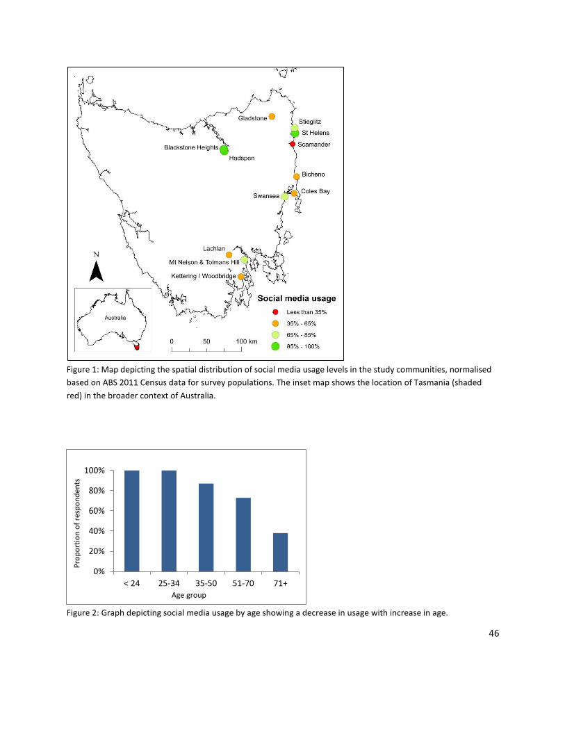
46
Figure 1: Map depicting the spatial distribution of social media usage levels in the study communities, normalised
based on ABS 2011 Census data for survey populations. The inset map shows the location of Tasmania (shaded
red) in the broader context of Australia.
Figure 2: Graph depicting social media usage by age showing a decrease in usage with increase in age.
0%
20%
40%
60%
80%
100%
< 24 25-34 35-50 51-70 71+
Pro
po
rtio
n o
f re
spo
nd
ents
Age group

47
Figure 3: Graph depicting motivations for social media use and the proportion of respondents for each.
Figure 4: Graph depicting the proportion of respondents who trust various sources of information through social
media (not specific to bushfire information).
3.4.4 The potential for VGI use in bushfire preparation and communication
The potential role of VGI and associated technologies, including social media, for bushfire preparation
was well recognised. 75% of respondents either agreed or strongly agreed that these technologies can
assist in improving preparation, and 74% believed they could provide an opportunity for authorities to
use local information provided by community members. But in preparing for a potential bushfire in the
next 1-2 years, just 48% of respondents said they would like to share and receive relevant information
through social media.
The survey also addressed the potential of VGI platforms to assist with bushfire communication.
Communication between community members and authorities was identified as important by 97% of
0%
10%
20%
30%
40%
50%
60%
70%
Pro
po
rtio
n o
f R
esp
on
den
ts
0%
10%
20%
30%
40%
50%
60%
70%
80%
Familyand/orfriends
Governmentagencies
NGOs orregistered
news media
Generalpublic
Nobody Other
Pro
po
rtio
n o
f re
spo
nd
ents

48
respondents. Participants were asked how they would prefer to receive information from authorities
regarding bushfires for different stages of disaster management. The results presented in Figure 5 show
distinct differences in preferences of communication methods before, during and after a bushfire.
Figure 5: Graph depicting the proportions of respondents preferring various communication methods for relevant
information from authorities at various stages of bushfire management.
3.5 Discussion There is a need for new approaches to engage citizens in risk reduction as shown in this evidentiary
analysis. Emerging technologies such as VGI platforms which allow dynamic and interactive exchange of
information may contribute to alternative engagement methods. However, the survey results highlight
limitations in the use of these technologies in bushfire management from recognised issues such as the
digital divide to more nuanced concerns that should be considered in any initiatives to promote uptake
of these technologies.
3.5.1 The need for new methods of risk reduction engagement
Respondents’ awareness of bushfire risk did not necessarily translate to levels of preparedness or
intentions to prepare (for similar findings see Whittaker et al. 2013; Eriksen & Gill 2010). Akin to the
notion of shared responsibility (see McLennan & Handmer 2012), respondents identified themselves as
responsible for their own bushfire preparation alongside authorities. But, although many respondents
stated there was a bushfire risk where they lived and felt vulnerable, fewer respondents have a TFSBSP
(though many were familiar with it) or intend to become more prepared in the future. Frandsen et al.
0%
10%
20%
30%
40%
50%
60%
70%
80%
Pro
po
rtio
n o
f re
spo
nd
ents
During abushfire
After a bushfire
For bushfirepreparation

49
(2011) argue that the goal of facilitating household and community bushfire preparedness cannot be
achieved simply by making information on risks and hazards available to people, a notion supported in
the literature (e.g. McFarlane et al. 2011; Lindell & Perry 2000). Sustained hazard preparation is a
function of how people interpret information in social and community contexts (Frandsen et al. 2011).
Thus, novel approaches for communicating bushfire preparedness information are needed; but not only
information communication from agency to citizens, but from citizens to agency and between citizens.
Approaches that are able to augment traditional processes of information dissemination and reception
while facilitating a more collective, two-way and integrated system of sharing local and authoritative
knowledge may in turn create a bushfire preparedness landscape of wider understanding, increased
connectedness, and greater participation in risk reduction activities, ultimately increasing disaster
resilience.
That individuals typically rated their personal preparedness higher than that of their community is
consistent with the notion of unrealistic optimism bias (see Sharot 2011). Unrealistic optimism
results in the likelihood of positive events occurring being overestimated and the likelihood of
negative events occurring underestimated. Individuals hold the belief that they are less likely to
experience a negative event than the average person (Gold 2008). For bushfire risk, this results in
individuals accepting the need for preparation for their community, but perceiving themselves as
having comparatively less need to prepare. Gold (2008) suggests that individuals exhibit unrealistic
optimism bias for reassurance. Fearing they may suffer the negative event, individuals distort
their reasoning so as to arrive at the comforting thought that they are at less risk than the average
person (Gold 2008). Practically addressing this issue is a challenging task for emergency
management and bushfire preparedness initiatives. Collection and distribution of local community
information through VGI technologies may facilitate increased understanding and a more realistic
appreciation of comparative risk by individuals of their surrounding community.
3.5.2 Potential for social media and VGI
It is evident that a large portion of the surveyed community is currently using VGI technologies. This
engagement is not limited to reading online content but involves people contributing their own data and
information, on a daily basis. Many already have the skills, motivation and physical access to the
technology required to utilise social media platforms for various tasks, including communicating with
family and friends, information acquisition and sharing photos/videos (Figure 3). Respondents also
recognised potential to extend to new tasks which utilise the same skillset, such as sharing local
knowledge and concerns relating to bushfire preparedness with community members. This presents a
potential new ‘virtual landscape’ for disaster preparedness engagement, facilitating both maintenance
of existing community ties and enabling new ones. By making users feel connected to a community and
increasing their knowledge of other members, social media sites can foster norms of reciprocity and
trust and, therefore, produce opportunities for collective action (Valenzuela et al. 2009).

50
The potential for the use of VGI is evident in this study not only in terms of technology uptake and
perceived possession of relevant skills, but also in terms of community interest. Most respondents felt
social media could assist in improving bushfire preparation, for instance. Though, less than half would
actually like to contribute and receive relevant preparation information with their community through
social media. This disconnect between perceived relevance and intent to directly engage is unclear and
suggests limitations to the use of VGI technologies in this space that require further research.
3.5.3 Limitations of social media and VGI
The survey data highlights important challenges to the utilisation of VGI methods in bushfire
preparation. The trend of decreasing social media use with increasing age (Figure 2) observed in this
study is consistent across the general Australian population (see Socialbakers 2014). The use of these
technologies may therefore not be applicable to all members of the community and it is inappropriate
to adopt a blanket approach for bushfire management across Tasmania using social media and other VGI
technologies. Research in other fields has shown that adopting strategies that utilise a broad-scale
approach to address diverse issues and that fail to account for local variation can result in ineffective
management policies (e.g. Haworth et al. 2013).
Technological factors may also limit VGI approaches resulting in further inequalities associated with
remoteness. Figure 1 reveals spatial variation in the current uptake of social media across the study
sites. This result may reflect technology access in particular areas (poor internet and mobile phone
coverage), or other factors, such as varying life situations. Communities with higher rates of social media
usage (Figure 1) tend to be in areas of higher population density (such as Launceston, St Helens, and
Hobart). It may be that these denser population centres have higher concentrations of younger people
(the group using social media the most; Figure 2) living in cities for increased employment and education
opportunities with consequently higher concentrations of retirees in smaller rural towns, for instance.
Concern relating to the trust and credibility of online information sources was an important study
finding. Identifying the most trusted information sources is considered important for improving the
efficacy of disaster risk communication (Haynes et al. 2008). While communication with family and
friends was most frequently given as a main reason for social media use (Figure 3), less than half of the
respondents reported family and friends as a trustworthy information source on social media (Figure 4).
Government agencies (such as TFS or local council), however, were cited as trustworthy by most
respondents. These results contrast with other studies of trust in disaster communication sources (not
specific to online tools or social media), such as work by Haynes, Barclay and Pigeon (2008), which found
friends and relatives to be the most trusted source for volcanic disaster information, and government
officials among the least trusted. Thus, the findings presented in this study are encouraging for
government agencies seeking to incorporate social media and online technologies into their emergency
management strategies. Low levels of trust in information sourced from the general public may be
preventing some community members utilising VGI.

51
Understanding preferences in communication methods and how they differ between stages of disaster
management (Figure 5) could have important implications for the success of management strategies
seeking to utilise a combination of communication tools. The results of this study concur with a recent
study by Taylor et al. (2012) on community response during Cyclone Yasi in which respondents preferred
to utilise a range of communication channels, including Facebook, TV news, online news and local radio
for seeking disaster information. It is evident that although social media is popular with a significant
percentage of the community there is still a strong desire for emergency communication via traditional
forms of media. The current study showed that social media is not the most preferred communication
medium in any stage of disaster management, but unlike other communication methods it shows the
least variation in preferences before, during, and after a bushfire event, i.e. there is a substantial and
consistent user base that communication through social media may be effective for across varying
situations.
3.5.4 Study limitations and future considerations
Common survey method challenges need to be recognised. Possible biases may be introduced during in-
person surveys if respondents alter their responses based on what they perceive to be more socially
desirable (Krosnick 1999; Fisher 1993), and question interpretation may influence survey responses
(Smith 1987). Despite pilot testing of the survey to minimise such issues, we posit that both these
phenomena are relevant to questions relating to the TFSBSP, for example, resulting in higher reporting
of respondents with a comprehensive TFSBSP than may actually be the case. Some respondents were
unable to distinguish between phases of the disaster management cycle. To illustrate, when asked about
social media use specifically for bushfire preparation some individuals commented on limitations such as
technologies going down during a fire, i.e. the response phase. Future studies would benefit from
placing greater emphasis on explaining key terms within the survey or employing methods of data
collection whereby increased opportunity is available for queries and explanations. Substantial value in
this study was gained from in-person surveys, in particular by facilitating question clarification (also
reported by Bird 2009). Consistent with Bird (2009), we observed in-person survey distribution to be
costly and time consuming, however. The self-administered survey methods (online and via mail) were
more efficient in terms of costs, community coverage, and response rates (Table 2), and afforded
respondents greater time to consider their responses, all of which are important advantages of this
mode of distribution (Bird 2009).
Significantly, this study provides evidence for the potential utilisation of VGI based on perceived need,
uptake of technologies and community interest, but it does not address how this potential could be
realised. To offer a possible example, VGI contributed by local community members to a dynamic
risk/hazard map could identify areas of importance or concern, such as community assets, vulnerable
people or areas, ‘safer’ places for evacuation, or vegetated areas in need of attention, thus further
empowering community members with knowledge of their surrounds and assisting in strategizing for
bushfire response. Further, spatial awareness of others’ activities may encourage individuals to mobilise
together and cooperate on preparation tasks that meet mutual needs and offer mutual benefits. Future

52
research should aim to extend this work with more detailed, localised studies to examine how the
potential of VGI initiatives highlighted in this paper can be most effectively realised.
3.6 Conclusion Results of the community survey conducted in this study demonstrate potential of VGI and associated
technologies to be useful in fostering engagement in bushfire preparation. Approaches utilising VGI
should not aim to replace traditional methods of bushfire communication and engagement. However,
with rapidly increasing access and familiarity of social media and VGI amongst the community, there is a
timely need to understand how they can act as a complimentary mechanism for increasing awareness of
disaster preparedness. The efficacy of these enabling technologies for promoting positive behavioural
change and empowering individuals to engage in risk reduction activities by contributing important local
information, in turn facilitating greater community awareness, connectedness and collaborative action,
needs to be evaluated.
3.7 Acknowledgements The authors would like to acknowledge the funding and support given to this research from the
Tasmania Fire Service. The support of the Commonwealth of Australia through the Cooperative Research
Centre program is also acknowledged. We would like to thank the survey participants for providing
valuable responses, and Joshua Whittaker for providing useful feedback on an earlier version of this
paper. University of Sydney HREC Approval No. 2013/1069.
3.8 References Bird, D.K. (2009). The use of questionnaires for acquiring information on public perception of natural
hazards and risk mitigation: a review of current knowledge and practice. Natural Hazards Earth
System Sciences, 9: 1307-1325.
Commonwealth Scientific and Industrial Research Organisation (CSIRO) (2007). Climate change in
Australia - Technical report: Department of Climate Change and Energy Efficiency, Australian
Government.
Department of Premier and Cabinet (DPAC) (2013). 2013 Tasmanian Bushfires Inquiry Report. Accessed
1 November 2014 from
<http://www.dpac.tas.gov.au/divisions/osem/2013_tasmanian_bushfires_inquiry_report/2013_tas
manian_bushfires_inquiry_report>.
Elwood, S., Goodchild, M.F. & Sui, D. (2012). Researching Volunteered Geographic Information: Spatial
Data, Geographic Research, and New Social Practice, Annals of the Association of American
Geographers, 102(3): 571-590.

53
Eriksen, C. & Gill, N. (2010). Bushfire and everyday life: exploring the awareness-action ‘gap’ in changing
rural landscapes, Geoforum, 41: 814–825.
Fisher, R.J. (1993). Social desirability bias and the validity of indirect questioning, Journal of Consumer
Research, 20: 303-315.
Flanagin, A. & Metzger, M. (2008). The credibility of volunteered geographic information, GeoJournal,
72: 137-148.
Frandsen, M., Paton, D. & Sakariassen, K. (2011). Fostering community bushfire preparedness through
engagement and empowerment, The Australian Journal of Emergency Management, 26(2): 23-30.
Frandsen, M. (2012). Promoting community bushfire preparedness: Bridging the theory–practice
divide (Doctoral dissertation, University of Tasmania). Retrieved 1 November 2014 from:
<http://eprints.utas.edu.au/15309/>.
Gold, R. (2008). Unrealistic optimism and event threat, Psychology, Health & Medicine, 13(2): 193-201.
Goodchild, M.F. (2007). Citizens as sensors: the world of volunteered geography, GeoJournal, 69(4):
211–221.
Goodchild, M.F. & Li, L. (2012). Assuring the Quality of Volunteered Geographic Information, Spatial
Statistics, 1(1): 110–120.
Haworth, B. & Bruce, E. (2015). A review of volunteered geographic information for disaster
management, Geography Compass, 9(5): 237-250.
Haworth, B., Bruce, E. & Iveson, K. (2013). Spatio-temporal analysis of graffiti occurrence in an inner-city
urban environment, Applied Geography, 38: 53-63.
Haynes, K., Barclay, J. & Pidgeon, N. (2008). The issue of trust and its influence on risk communication
during a volcanic crisis. Bull Volcanol, 70: 605-621.
Intergovernmental Panel on Climate Change (IPCC) (2012). Managing the risks of extreme events and
disasters to advance climate change adaptation, In Field, C.B., Barros, V., Stocker, T.F., Qin, D.,
Dokken, D.J., Ebi, K.L., Mastrandrea, M.D., Mach, K.J., Plattner, G.-K., Allen, S.K., Tignor, M. and
Midgley, P.M. (eds), A Special Report of Working Groups I and II of the Intergovernmental Panel on
Climate Change, Cambridge University Press, Cambridge and New York.
Krosnick, J.A. (1999). Maximising measurement quality: principles of good questionnaire design, In
Robinson, J.P., Shaver, P.R. and Wrightsman, L.S. (eds), Measures of Political Attitudes, Academic
Press, New York.

54
Lindell, M.K. & Perry, R.W. (2000). Household adjustment to earthquake hazard: A review of research,
Environment and Behavior, 32(4): 461-501.
McFarlane, B.L., McGee, T.K. & Faulkner, H. (2011). Complexity of homeowner wildfire risk mitigation:
An integration of hazard theories, International Journal of Wildland Fire, 20: 921-931.
McLennan, B. & Handmer, J. (2012). Reframing responsibility-sharing for bushfire risk management in
Australia after Black Saturday, Environmental Hazards 11(1): 1-15.
Paton, D. (2003). Disaster Preparedness: A social-cognitive perspective, Disaster Prevention and
Management, 12: 210–216.
Prober, S., O’Connor, M. & Walsh, F. (2011). Australian Aboriginal people’s seasonal knowledge: a
potential basis for shared understanding in environmental management. Ecology and Society, 16(2):
12-27.
Sharot, T. (2011). The optimism bias. Current Biology, 21(23): R941-R945. Accessed 14 May 2014 from:
<http://ac.els-cdn.com/S0960982211011912/1-s2.0-S0960982211011912main.pdf?_tid=4edc5042-
db04-11e3-b667-00000aab0f02&acdnat=1400029910_632c23c84fd6246cf9a3ee63fe0b43a6>.
Smith, T. (1987). That which we call welfare by any other name would smell sweeter. An analysis of the
impact of question wording on response patterns, Public Opinion Quarterly, 51: 75-83.
Socialbakers (2014). Australia Facebook statistics. Accessed 21 May 2014,
<http://www.socialbakers.com/facebook-statistics/Australia>.
Taylor, M., Wells, G., Howell, G. & Raphael, B. (2012). The role of Social media as psychological first aid
as a support to community resilience building, A Facebook case study from ‘Cyclone Yasi Update’,
The Australian Journal of Emergency Management, 27(1): 20-26.
Tran, P., Shaw, R., Chantry, G. & Norton, J. (2009). GIS and local knowledge in disaster management: a
case study of flood risk mapping in Vietnam. Disasters, 33(1): 152-169.
Valenzuela, S., Park, N. & Kee, K. (2009). Is there social capital in a Social Network Site?: Facebook use
and college students’ life satisfaction, trust, and participation, Journal of Computer-Mediated
Communication, 14(4): 875-901.
Victorian Bushfires Royal Commission (VBRC) (2009). Emergency Management Australia Disasters
Database - Major Bushfires in Southern Australia: Hobart and Region, Tasmania: Bushfires.
Accessed 1 November, 2014 from <http://www.royalcommission.vic.gov.au/getdoc/a0840c4d-
9afa-461b-884f-fbfb0c008b06/RSCH.030.001.0122.pdf>

55
Whittaker, J., Haynes, K., Handmer, J. & McLennan, J. (2013). Community safety during the 2009
Australian ‘Black Saturday’ bushfires: an analysis of household preparedness and response,
International Journal of Wildland Fire, 22(6): 841-849.

56
CHAPTER 4: EMERGENCY MANAGEMENT PERSPECTIVES
ON VOLUNTEERED GEOGRAPHIC INFORMATION
This chapter corresponds with the following publication (see Appendix A):
Haworth, B. (2016). Emergency management perspectives on volunteered geographic information:
Opportunities, challenges and change. Computers, Environment and Urban Systems, 57: 189-198.
4.1 Abstract Volunteered geographic information (VGI) refers to the widespread creation and sharing of geographic
information by private citizens, often through platforms such as online mapping tools, social media, and
smartphone applications. VGI has shifted the ways information is created, shared, used and
experienced, with important implications for applications of geospatial data, including emergency
management. Detailed interviews with 13 emergency management professionals from eight
organisations across five Australian states provided insights into the impacts of VGI on official
emergency management. Perceived opportunities presented by VGI included improved communication,
acquisition of diverse local information, and increased community engagement in disaster management.
Identified challenges included the digital divide, data management, misinformation, and liability
concerns. Significantly, VGI disrupts the traditional top-down structure of emergency management and
reflects a culture shift away from authoritative control of information. To capitalise on the opportunities
of VGI, agencies need to share responsibility and be willing to remain flexible in supporting positive
community practices, including VGI. Given the high accountability and inherently responsive nature of
decision making in disaster management, it provides a useful lens through which to examine the impacts
of VGI on official authoritative systems more broadly. This analysis of the perceptions of emergency
management professionals suggests changes to traditional systems involve decentralisation of power
and increased empowerment of citizens, where value is increasingly recognised in both expert and
citizen-produced information, initiatives and practices.
4.2 Introduction In January 2013 Australia was in the midst of a bushfire (wildfire) disaster. Fire swept across the state of
Tasmania, stretching capacities of emergency services and devastating communities (DPAC 2013). No
fatalities occurred during the blazes, but the event left many in need of emergency assistance with

57
significant access issues due to road closures, power and communications disruptions, and the
destruction of 203 residential buildings (DPAC 2013).
As the disaster unfolded people flooded social media to connect to each other and share relevant
geographic information and resources. One Tasmanian resident observed the growing online activity
and set up a social media page to help coordinate the flow of information. Interest in the Facebook page
Melanie Irons established, “Tassie Fires We Can Help” (www.facebook.com/tassiefireswecanhelp),
rapidly spread with people sharing their locations, their requirements for help, offers of assistance and
other disaster related information (ABC 2013). Within 24 hours the page had gained over 17,000
followers and had reached over 2 million individuals (DPAC 2013; ABC 2013).
“We understood quite early on that people were trusting this page, that people were
sharing information and it was getting results. People were putting out requests for fuel,
for generators, for food and people were responding. So it almost bypassed the official
channels. Well, it did. It essentially became a way for volunteers to communicate directly
with people that needed help, without having to go through the official channels.”-
Damien McIver, journalist (ABC 2013).
With emergency services consumed by other tasks, such as fighting the spread of fire, Ms Irons’ page
filled critical gaps in the response to the disaster. Social media and geographic information volunteered
by the public proved highly valuable in responding to the disaster through increasing connectedness,
sharing information quickly and widely, and provision of crucial local perspectives and data that met
specific local needs. This citizen-driven initiative engaged the public and mobilised the population to
undertake a whole suite of important tasks not able to be completed by the official emergency
response.
The activities described above fall under the definition of volunteered geographic information (VGI), and
in a disaster management context have also been labelled “digital volunteering” (McLennan et al. 2015),
or “digital humanitarianism” (Burns 2014), among other terms. VGI refers to the widespread voluntary
engagement of private citizens in the creation of geographic information, predominantly through
sources such as social media, smartphones and inexpensive online mapping tools (Goodchild 2007;
Elwood et al. 2012). VGI is quickly becoming a new type of asserted geographic information
complementary to authoritative geographic information collected by governmental agencies or private
organizations (Jiang & Thill 2015). Neither the practice of citizens contributing geographic information
nor high public involvement in disasters are new. However, the rise of information communication
technologies, broadband internet and Web 2.0, along with the proliferation of location-acquisition
technologies such as global positioning systems and smartphones, has dramatically enhanced these
practices and increased their visibility (Goodchild 2007; Palen & Liu 2007). VGI has shifted the ways
geographic information is created, shared, used and experienced. This has important implications for
various applications of geospatial data, including disaster management. VGI technologies enable cost-

58
effective, rapid sharing of diverse geographic information from large numbers of community members.
But VGI also presents new challenges for disaster management, including a lack of data quality
assurance and issues surrounding data management, liability, and the digital divide (see Haworth &
Bruce 2015).
The implications of these changing social practices need to be considered in the context of traditional
disaster management. Historically, disaster management has been an authoritative system with a top-
down ‘command-and-control’ structure (Palen & Liu 2007). As with traditional map-making and
geography more broadly, the system was centred on experts, in this case emergency organisations,
disseminating controlled messaging and services to the public. In this hierarchical system, authorities
effectively hold power over information while citizens often remain passive end-users. Assistance and
services to communities are delivered through the four phases of disaster management: Prevention,
Preparedness, Response and Recovery (PPRR) (Prosser & Peters 2010; Zakour & Gillespie 2013). In
recent years, there have been international moves towards disaster management approaches that focus
on resilience and building community capacity with emphasis on shared responsibility (Prosser & Peters
2010; McLennan & Handmer 2012). Current emergency management policy in Australia aims to use the
PPRR model to achieve a more resilient nation (Prosser & Peters 2010). Increasingly, community
engagement is becoming a key feature of strategies seeking to achieve this goal (e.g. Frandsen et al.
2011).
The “Tassie Fires We Can Help” example, like other cases of online public volunteering or crowdsourcing
information for disaster management (see Meier 2012; Bird et al. 2012), represents a disruption to
traditional authoritative systems of disaster management. If traditional disaster management is centred
on the notion of experts having control, the bottom-up, unpredictable and spontaneous nature of VGI
challenges conventional authoritative practices within disaster management. Traditional command-and-
control models “do not easily adapt to the expanding data-generating and –seeking activities by the
public” (Palen & Liu 2007, p.727), and instances of digital volunteering in emergency management have
thus far largely occurred outside of formal emergency management systems (McLennan et al. 2015).
The purpose of this study is to explore the implications of VGI for authoritative emergency management.
Challenges associated with the impacts of digital humanitarianism identified by volunteers themselves
have recently been reported (see Burns 2014). This paper examines the perspectives of individuals
working in formal disaster management. Interviews with emergency management professionals
provided insights into the benefits and challenges of VGI, opportunities for ensuring complementarity
between VGI and authoritative practices, and perceived changes in disaster management catalysed by
VGI. I discuss the implications of VGI on traditional expert systems more broadly with particular
reference to the discipline of geography.
59
The terms disaster management and emergency management are used interchangeably, but the paper’s
focus is on emergencies associated with natural hazard events, such as fires, earthquakes, floods and
storms.
4.3 Background to VGI and emergency management Academic research into VGI and emergency management has largely focussed on the application of
citizen-contributed data in disaster response (Haworth & Bruce 2015). To provide some examples, after
the devastating 2010 Haiti earthquake, volunteers from all over the world worked together to map the
event online using information provided by the public. In the days following the earthquake over 600
volunteers contributed over 1 million edits for Haiti to OpenStreetMap (Meier 2012). Similar
volunteered mapping, data sharing and knowledge creation has also been critical for responding to the
recent Nepal earthquake crisis (Bailey 2015). The Ushahidi Crowdmap platform (www.crowdmap.com)
was utilised during the Haiti earthquake to collect and map information contributed by those impacted
by the disaster, notably through a text message service (Meier 2012; Crawford & Finn 2015). VGI and
Crowdmap also proved useful in responding to cyclone and floods in Queensland, Australia in 2010/11
(McDougall 2011). Social media was used by impacted community members and authorities to
effectively collate and share information during the flood events and combat the spread of
misinformation (Bird et al. 2012; Taylor et al. 2012). Further, VGI was demonstrated to provide an
alternative to official information sources during wildfires in Santa Barbara in 2007-2009 (Goodchild &
Glennon 2010).
Studies emphasise benefits and important considerations of VGI in disaster management (see Haworth
& Bruce 2015). Benefits include timely information exchange and promotion of connectedness (e.g.
Taylor et al. 2012), provision of complimentary information for disaster mapping in regions where other
spatial data are poor or absent (e.g. McDougall 2011), and the ability to capture data in near-real time
without limitations of other technologies, such as satellite imagery being affected by weather (e.g.
Triglav-Čekada & Radovan 2013). Challenges reported that need careful consideration for effective VGI
use include issues associated with demographics, internet use and technology access (Haworth et al.
2015), data quality (Goodchild & Li 2012; Ostermann & Spinsanti 2011), trust and credibility of VGI
sources (Flanagin & Metzger 2008), security (Shanley et al. 2013), data management for large volumes
of data (Spinsanti & Ostermann 2013), and legal concerns around privacy and liability (Scassa 2013).
While some claim VGI can empower citizens with the ability to georegister and transmit observations
through the internet (Goodchild & Glennon 2010), others have argued VGI can also act to marginalize
people, furthering the ‘digital divide’ (see Van Dijk & Hacker 2003; Sui et al. 2013; Crawford & Finn
2015). Haworth and Bruce (2015) question the link between VGI and citizen empowerment, arguing the
relationship is a complex one dependent on a number of factors including community make-up,
administrative structures, and existing power relations. Power has been defined as the ability to get
things done (Pfeffer & Salancik 1978). As described in the introduction to this article, power in
emergency management traditionally lies with authorities. Power, or ‘the ability to get things done’,
60
may be highly limited for particular communities or individuals. Morrow (1999) asserts the impacts of
disasters are determined by everyday patterns of social interaction and organisation, and disaster
vulnerability is constructed by the social and economic circumstances of everyday living. Risk is
concentrated in certain categories of people, such as the poor, ethnic minorities, single-parent
households, or women, for example (Morrow 1999). Moreover, vulnerability factors frequently occur in
combinations, so an individual who aligns with multiple risk categories will experience higher
vulnerability and reduced power in emergency management. It has been shown that people with strong
networks fare better in disasters, and social capital ties may work to improve community resilience
(Murphy 2007). The greatest contribution of VGI in disaster management may be in strengthening
community ties through the sharing of local knowledge in communities, increasing the power and
resilience of those vulnerable. Goodchild (2007) posits communities’ daily life activities and spatial
patterns at a local level may be where VGI offers the most interesting and lasting value.
Given this context, it is important to understand how technological and social practices such as VGI, that
are already occurring, are impacting the field of emergency management. Technological research in this
field continues to address challenges and develop innovative ways to utilise VGI. Thus, it is increasingly
important to understand the existing emergency management settings in which these innovations may
be adopted. Significantly, this study goes beyond exploring applications and examines the implications
of VGI from the perspective of current emergency management professionals. This novel perspective is
important for understanding how VGI can be used for effective disaster management in the future.
4.4 Methods Study participants were selected based on professional engagement in emergency management in a
formal paid capacity (e.g. state emergency agency, local council or emergency volunteering
management organisation). Representation across different organisations, regions in Australia, and
professional expertise was sought to ensure a breadth of participant backgrounds from local community
engagement roles through to senior government policy-makers. More specifically, key informants were
chosen for having experience relevant to one or more of the key focus areas of the study, including
disaster communication, citizen participation, changes in emergency management structures, and/or
advances in geospatial information technologies and their application in emergency management,
including those that enable VGI and increased community contributions, such as the internet and social
media. By accessing the industry and research networks of the author and project supervisors,
participants were recruited purposively initially, and secondly through a snowball technique. All
identified potential interviewees were invited to participate in the study via email letter.
All participants were representing their views as emergency management professionals and not
necessarily the official views of their respective agencies. Thus the participants, including details of their
specific roles and organisations, will remain anonymous. In total 18 professionals were invited to be
interviewed. Two could not be interviewed due to their unavailability and three did not respond. 13
semi-structured interviews were conducted, six with females and seven with males, with participants

61
from eight organisations across five Australian states. All participants had at least 12 months experience
working in professional emergency management and their collective expertise spanned the hazards fire,
flood, storms, cyclones and earthquakes.
Each interview lasted approximately 60 minutes. Interviews were chosen over other qualitative research
methods, such as focus groups, to ensure participants were providing individual responses and were not
influenced by others. To establish consistency, each participant was presented with the same topics for
discussion, broadly including the following: current challenges in emergency management and
community engagement; experiences of VGI in emergency management; perceived strengths and
weaknesses of VGI technologies and practices; VGI in the context of authoritative emergency
management; and, how community VGI practices can best compliment official emergency management
and vice versa (Appendix F). The outcomes of other interviews were not discussed with any participant.
It is acknowledged that the presence of the researcher may have influenced participants’ responses. For
example, a common consideration of interviews is that participants may provide responses they feel
more socially acceptable or more desirable by the researcher (Krosnick 1999; Fisher 1993). Potential for
this introduced bias was not assessed within the scope of the study. Interviews were audio recorded,
transcribed, and coded manually by the author following an inductive approach. The adopted methods,
analysis process and findings were discussed regularly, verified as appropriate, and conferred with the
project supervisors and multiple researchers independent of the study to strengthen dependability (see
Saumure & Given 2008). Thematic content analysis (Anderson 2007) identified key categories that
summarise the interview data. The findings are presented and discussed in the next section.
4.5 Findings and discussion
4.5.1 Opportunities presented by VGI
Present in all interviews was the notion of VGI presenting opportunities, many of which were centred on
advantages for citizens. This included opportunities for authorities to communicate with communities,
and for communities and individuals to share data. The opportunities identified through interviews are
presented in Table 1 with examples of evidence from participants. They are then discussed further in the
subsections that follow. Figure 1 shows the proportion of participants who identified and discussed
topics relevant to each of the opportunity categories listed in Table 1.

62
Table 1: Opportunities associated with VGI identified by emergency management professionals.
Examples are a representative sample of responses. “PX” refers to a number assigned to individual
participants.
Opportunities Evidence examples
Increased reach
of
communications
P5. They have incredible power in terms of being able to reach large
numbers of people in broad and targeted ways.
P6. Strengths are that there is another medium for delivery. So, more
people or the same people in different ways are getting access to
information.
P1. The idea of getting information to that demographic [those disengaged from
their broader community – typically from low socio-economic backgrounds
untrusting of authorities] is very important. They rely very much on their friend’s
social media.
P6. With younger people becoming more comfortable with those sorts of
things and being able to mark-up maps themselves, it’ll all become a bit
easier, theoretically, for people to understand things around them.
Increased
exchange of local
knowledge: two-
way dialogue
P2. I think it is incredibly valuable for people to communicate with each
other…it’s [community resilience] about connectedness. It’s about a sense
of belonging and a sense of place and people being aware of each other and
supporting each other and being able to assist each other, planning
together rather than at a household level.
Individual
empowerment
P7. All these platforms, they’re making it easier for them [community
members] to collaborate and share, make their own maps and make their
own plans and fundamentally help each other.
P12. The way technology is being used now is a huge liberator for a lot of
people, so then it does go to the heart of control and oppression, and
control where information has always been a source of power and now

63
information is readily available to a lot of people and they can use it in a
whole range of different ways, which can strengthen their cause.
Increased
individual self-
worth
P10. I think sites like that are good because people in the community want
to feel as though they’re doing something or they can contribute.
Increased spatial
awareness
P13. The value of digital mapping to bring it together so they get a holistic
view of the whole catchment. So therefore, that’s a way of getting localized
information, bringing it together so they can look at it as a bigger patchwork
and then to see how they all slightly thought of things in a different way.
P12. I think there’s scope to use geospatial tools and mapping... they’re
extremely important when you’re having conversations with communities
around prevention and preparedness… extremely effective for
demonstrating to people what their risk is, and then helping them identify
strategies for how they might reduce or mitigate their risk.
P3. Once you’ve got that map form and you draw some arrows and things
on it people really, they can comprehend that. You can easily put up photos
of houses burning, but when you put down a map with some lines on it that
show where the fire was at 15 minute intervals coming across the landscape
that they recognize, that is really, really powerful.
P6: With younger people becoming more comfortable with those sorts of
things and being able to mark-up maps themselves, it’ll all become a bit
easier, theoretically, for people to understand things around them.

64
Figure 1: Graph presenting the proportion of participants who identified and discussed particular
opportunities of VGI in emergency management.
4.5.1.1 Increased reach of communications
Technologies such as Web 2.0, social media and mobile and smart devices were seen as useful for
increasing the reach of communications (Taylor et al. 2012 report a similar finding). Figure 1 shows this
was the most widely identified and discussed benefit of VGI. Participants positively described the fast
pace of information sharing and the speed of online communication, as well as the large volume of
people engaged with social media sites like Facebook and Twitter, enabling further communication and
providing alternative means for information dissemination. These benefits have been reported
elsewhere (e.g. Gao et al. 2011; McDougall 2011), and emergency management perspectives here
provide validation from an operational standpoint.
Further, increasing use of VGI technologies may be expedient for engaging people in communities who
are typically difficult to engage through more traditional disaster communication methods (e.g.
community events or media advertising), such as those from more disadvantaged socio-economic
backgrounds. For those distrustful of authorities or government agencies, information from outside
traditional channels is valuable. Relevant information from their friends, community members or peers
shared on social media may be useful for raising disaster awareness and communicating important
information that may otherwise be disregarded. Disaster messaging needs to appear relevant to
recipients and informal personal networks can reinforce, undermine or deflect official communications
(Handmer 2002).
4.5.1.2 Increased exchange of local knowledge and two-way dialogue
The increased ease for people to share information was considered a major strength of VGI (Figure 1).
Community sharing of information was said to increase risk awareness, facilitate the exchange of local
0%
10%
20%
30%
40%
50%
60%
70%
80%
90%
100%
Increased reachof
communications
Increasedexchange of
local knowledge
Individualempowerment
Increasedindividual self-
worth
Increased spatialawareness

65
knowledge, and assist with building community disaster resilience through increasing connectedness of
individuals. The potential for two-way dialogue through social media was described, allowing not only
authorities to communicate more effectively with the public, but individuals to communicate with
authorities, and for authorities to utilise community-supplied information in their planning and response
strategies.
In a study of access to communications during two disaster case studies, Boon (2014) found the most
effective disaster communication to be two-way and locally derived, allowing more personally-relevant
information to be obtained and acted upon. Contributions from individuals made through social media
and other VGI platforms have proved highly useful in the management of numerous recent disaster
events (see Haworth & Bruce 2015). For disaster preparation, community input has been acquired in the
past through community consultation and forums. VGI and two-way dialogue may provide opportunity
to reduce limitations associated with these traditional methods, such as the time and resources
required.
4.5.1.3 Individual empowerment
Interview results suggest VGI can empower people through information access, enhanced community
autonomy, and increased capacity to complete tasks without the assistance of authorities, both freeing
up time and resources for authorities to undertake other tasks and increasing community
connectedness. Taylor and colleagues (2012) report social media can empower individuals to help
themselves through provision of accurate, timely and relevant information, and provides a mechanism
to connect with other community members.
4.5.1.4 Increased individual self-worth
The ability of VGI to assist people in helping others during a disaster was positively described, giving
community members a sense of purpose. In particular, social media platforms like the “Tassie Fires We
Can Help” Facebook page provide opportunity for individuals to gain a sense of worth or usefulness.
While motivations for VGI and crowdsourcing contributions vary widely (Haklay 2013), sense of purpose
and the feeling of contributing to something important is a key motivation (Good & Su 2011). In
managing emergencies citizens often have a strong desire to help, especially during disaster response
and recovery. VGI presents mechanisms to enable this. Indeed, Ms Iron’s motivation for establishing
“Tassie Fires We Can Help” during the Tasmanian bushfires was a feeling of, “Well what can I do to
help?” (ABC 2013).
4.5.1.5 Increased spatial awareness
The spatial component of VGI is important for representing disaster risk and preparedness information.
Mapping was described as providing alternative ways for individuals to engage with relevant
information, as well as for individuals to see their personal or local information in a broader context of
community risk.

66
The increasing ubiquity of technologies and the increasingly commonplace use of maps in the public
domain through platforms like Google Maps and in-car navigation systems provide further opportunities
for mapping, both expert-driven and VGI, to be useful for communicating risk and building community
awareness in disaster management. The pervasiveness of spatially-enabled technologies and
consequent increased familiarity with mapping further highlights the potential of VGI in natural disaster
management.
4.5.2 Challenges presented by VGI
Currently emergency management organisations do not appear to encourage or foster practices that
would best-enable the opportunities of VGI to be realised. While perceptions of VGI-use varied within
and between organisations, predominantly social media were being used as one-way communication
tools for authorities to broadcast information, typically in the response phase, suggesting limited
understanding of the potential of VGI in promoting information sharing and inclusion of community
stakeholders at different phases of disaster management. While interviews suggested agencies were
feeling increased expectation from the public to be using social media for two-way dialogue,
participants expressed sentiment that organisations were still trying to determine how to use
information provided through those communications. Developing mechanisms for utilising VGI in that
manner was not perceived as a priority with several challenges and limitations associated with VGI for
emergency management emerging from interview discussions. These are presented in Table 2 and
discussed further below. Figure 2 shows the proportion of participants who identified and discussed
topics relevant to each of the challenge categories listed in Table 2.
It should be noted that, in contrast to the opportunities of VGI which placed emphasis on benefits to
citizens, the challenges identified by emergency management professionals appear largely institutional
(e.g. lack of data management resources or fear of liability) or structural (e.g. the digital divide). This
suggests changes to current emergency management systems may be required for more effective use of
VGI, and this is discussed further in later sections of the paper. In environmental and regional planning,
Brown (2012) argues significant limitations to positive impacts of public participatory methods have
been institutional constraints such as regulatory barriers, fear of unpredictability, and lack of specific
incentives for agencies to engage.

67
Table 2: Challenges associated with VGI identified by emergency management professionals. Examples
are a representative sample of responses. “PX” refers to a number assigned to individual participants.
Challenges Evidence examples
Demographics,
digital divide and
internet access
P1. The more senior people glaze over even when I just talk about the
website, and how to access alerts and information. But from my
experience, the majority people coming to my [community preparedness]
events are middle class middle age, so the majority of them will be using
social media and smartphones and things like that to access information.
P5. Particular ages, particular demographics are more likely to engage with
it than others, and not everybody is tech savvy or IT savvy and wants to
engage with VGI.
P8. I think if people were more familiar and accustomed to it, then we
would see the benefits of it and how they could use it for themselves.
P13: If geography plays a part in ‘has’ and ‘has-nots’, then it’s probably the
same people in those geographies that are most at [disaster] risk. They are
in the inaccessible locations or they are in the more remote locations, and
therefore will need greater support when something happens. And yet,
they’re probably the most prone to not being able to access things through
those ways. Its people in the cities who have it all and they’re probably the
least likely to need it.
Infrastructure
disruption during
disasters
P8. Sometimes with disasters power gets cut. So how is that information
still going to get out there if you’ve not got power in an area for 12 days or
more?
Resources required
to manage VGI
P6. We will be challenged in a major event to be able to monitor
everything that’s going on.
P7. Any information that comes from the public or an agency, it’s not
useful until it’s processed to become something. A photo without

68
metadata is just junk. So we’re trying to build that process of capturing the
metadata.
P13. But if we’re struggling to use the vasts of information we have, that
we’ve collected over the last hundred years even, then we’re going to even
more so struggle with the vast volumes of information, big data and such
like that, in an instantaneous sort of environment.
P7. Things are a bit too temporary sometimes. They pop up and people
contribute and I’m sure there’s benefit that comes out but then they fizzle
off.
Data quality, trust
in online sources
and
misinformation
P6. At times organizationally we had a few problems with information that
was being transferred because it wasn’t accurate information, it wasn’t
validated…there became self-correction, in that other users were able to
correct things. It got such a momentum of scale that the breadth of people
was able to correct the group.
P2: Often the community will moderate it themselves. If somebody says
something really silly they’ll often be howled down by their peers, which is
really lovely. Somebody says something inappropriate and everybody deals
with it, without the organization having to be in control.
P9: The unauthorized stuff can actually be better quality in terms of
accuracy and timeliness than the official. We naturally default to the
official version, but by the time it has actually been through its verification
and authorization it may actually be of less value or less quality than the
stuff that’s getting generated by the community on the ground in real
time.
P12. I actually think that’s not as serious an issue as people make it out to
be, and I think that agencies use it as a barrier to actually engage and to be
a part of it... I think it’s a little bit overblown this notion that people will

69
misuse it and it’ll be full of misinformation, because I think that’s only a
very small percentage of people that get on there and do those things.
Perceived legal
concerns: a)
agency reputation;
b) liability
P2. I think it’s [data quality] the thing that emergency services fear most
and I suspect that their fear is disproportionate. I think in the current
climate with royal commissions and coroner’s inquests, emergency
services are actually quite anxious. If we were signed up to that page and
people were having this conversation and we didn’t correct them, are we
liable and can we be on every page where everybody is having a
conversation? What is our responsibility; what’s our liability?
Figure 2: Graph presenting the proportion of participants who identified and discussed particular
challenges of VGI in emergency management.
4.5.2.1 Demographics, digital divide and internet access
Demographics, the digital divide and access to the internet were reported as major limitations for the
organisational uptake of VGI and within communities. Social media and smartphones were seen to be
used less by older people, those with particular limiting circumstances and low socio-economic status,
and people living in remote areas, limiting the application of VGI for whole-of-community strategies.
This is in part related to infrastructure and physical access to internet and mobile coverage, as well as
affordability of technology, time and priorities, and necessary skills.
But it was also suggested that age itself is not the limiting factor, but age is a determinate of lower
familiarity with the technology. Unfamiliarity with technology shouldn’t be seen as a limitation in itself,
0%
10%
20%
30%
40%
50%
60%
70%
80%
90%
100%
Demographics,digital divide andinternet access
Infrastructuredisruption
during disasters
Resourcesrequired tomanage VGI
Data quality,trust in onlinesources and
misinformation
Perceived legalconcerns

70
but highlights the need for alternative approaches that cater for varied skills and interest, especially if
individuals perceive benefits to be gained.
The geography of access to VGI-enabling technologies was described alongside geographies of risk and
location. Those people in society already marginalised are often the most vulnerable to negative disaster
impacts (Hewitt 1997), and a growing gap between those with technology access and those without will
further marginalise some while unequally benefiting others. Information is often least available where it
is most needed (Sui et al. 2013) and the use of crowdsourced data has been shown to augment existing
unequal power relations and enhance inequalities (Crawford & Finn 2015). This has important
implications for disaster management. How can VGI benefit those who cannot use VGI technologies?
Haworth, Bruce and Middleton (2015) showed social media use to be concentrated in urban areas. Will
people in rural areas not receive the same timely information spread through social media? In some
cases it is an individual’s choice to live in such an area, and the connection between rurality and lack of
technology use may not always correlate with socio-economic disadvantage. However, often the
opportunity for individuals to relocate is limited due to economic or other factors. Emergency
management needs to plan and strategize for the majority and regardless of basis, the digital divide
needs priority consideration. Sui, Goodchild and Elwood (2013) argue that while the world is shrinking,
the divide between those with access to production and use of geographic data and those without is
increasing significantly and will continue to be a major challenge for geographic information science.
4.5.2.2 Infrastructure disruption during disasters
Participants frequently cited potential technological failures during disaster events as a limitation to the
utility of VGI. For those that are engaged online, reliance on communication through web platforms may
be problematic in the event of disaster if infrastructure is disrupted. VGI shouldn’t be considered the
primary communication solution and platforms like social media should be employed as part of a suite
of engagement and communication methods. Studies have shown the public prefer to utilise a range of
communication mediums for disaster-related information, including Facebook and other social media,
television, radio, online sources and print media (Haworth et al. 2015; Taylor et al. 2012).
Participants at a social media workshop at the 2014 Australia and New Zealand Disaster and Emergency
Management conference reported similar concerns (Anikeeva et al. 2015). The possibility of network
failure, particularly in remote areas with poor network coverage, was identified as a barrier to
organisational adoption of social media. It was also acknowledged, however, that social media platforms
are often more robust than standard websites and less prone to failure during periods of high traffic,
such as emergencies (Anikeeva et al. 2015).
4.5.2.3 Resources required to manage VGI
Organisations require substantial resources to utilise VGI effectively and data management was
identified as a key challenge by a large proportion of study participants (Figure 2). Systems need to be
established to mine data supplied by the public, which may involve methods for filtering large amounts

71
of data from social media, monitoring feeds to combat rumours in near real-time, processing
information to meet agency needs and standards, or platforms for structured input of geospatial data,
as well as necessary personnel. Many organisations lack dedicated staff and the responsibility of
managing social media or other VGI is often given to those with a special interest in the technology, who
then must find additional time for these tasks around their primary job (Anikeeva et al. 2015).
Agencies already have many and varied forms of data and knowledge to handle without the challenges
of increasingly large amounts of diverse information supplied through VGI, and a balance between the
increased workload and required resources and the benefits to be gained from utilising VGI needs to be
considered. Data management needs to address how individual pieces of important local knowledge can
be extracted and retained from large aggregated datasets.
The resourcing required for maintaining VGI platforms was also described by participants. Whether it is
an official platform or entirely community-driven, the sustainability of VGI platforms was identified as a
limitation. Often social media pages or local mapping initiatives emerge and are useful for a time before
usage declines. Episodic trends could be related to contributors’ motivations, or data/system
management.
4.5.2.4 Data quality, trust in online sources and misinformation
Data quality is another key concern, and was identified and discussed by emergency management
professionals more than any other challenge associated with VGI (Figure 2). Participants described
issues of trust in online sources and management of misinformation, particularly on social media. A
2014 survey of community members revealed trust is also a limitation to VGI for the general public
(Haworth et al. 2015). Though, Tierney and others (2006) have described how traditional mass media
and even official discourse also promote false information and ideas with negative consequences in
disaster scenarios. A commonly identified strength of VGI is the speed and volume of information
dissemination, but these mechanisms can also work to spread misinformation. Further, the information
that is ‘credible’ may not be of content or form that is useful for emergency services’ needs. Numerous
studies have reported similar findings, with some documenting quality issues in social media data
(McDougall 2011; Gupta & Kumaraguru 2012), the risks to emergency responders and relief agencies in
using these data (Shanley et al. 2013; Goolsby 2013), and mechanisms for attempting to determine
quality in VGI (Ostermann & Spinsanti 2011; Castillo et al. 2013). Others have argued the ‘crowd’ can
manage many of these issues themselves, much like the Wikipedia model (see Giles 2005), with large
volumes of people online observing, moderating, correcting and therefore reducing errors (Haklay et al.
2010), and perspectives from emergency management professionals in this study provide support for
this notion.
Information volunteered by the public is sometimes the most current and the best quality available. 10
days after the Haiti earthquake in 2010, the head of the U.S. Federal Emergency Management
Association said that humanitarian crowdsourced mapping provided the most comprehensive and up-

72
to-date information (Meier 2012). This was also recognised in the current study, with participants
describing the challenge for agency information verification systems to keep pace with the speed at
which the public can generate, verify and share data. Some participants perceived the benefits of VGI to
outweigh data quality issues and suggested these concerns were overstated when compared to the
actual occurrence of harm caused by unverified posts.
4.5.2.5 Perceived legal concerns
The possibility of legal ramifications associated with VGI was a commonly cited concern. There were two
main components to this. First, the reputation of the agency could be impacted through association with
negative online events or activities. A negative impact on agency reputation may erode community trust
and decrease the effectiveness of official emergency management strategies, potentially resulting in job
insecurity, legal ramifications, or further damage and loss during a disaster. Second, people acting on
information shared online with or without some connection to the agency may result in liability and
legal complications if agencies are deemed responsible in some way. For example, should agencies be
responsible for correcting all the rumours or misinformation circulating on social media? These issues
are particularly important given the traceability and permanency of some online data.
Questions of who is liable and when are among the most important questions which impact VGI (Rak et
al. 2012), and Shanley et al. (2013) report liability concerns may deter emergency management
organisations from utilising VGI. Scassa (2013) argues VGI site operators, users, and contributors require
awareness of the legal and ethical issues that may be triggered by their activities. Important to consider
are issues of intellectual property, defamation, and liability for faulty information, particularly as
websites have a global reach and laws differ across jurisdictions (Scassa 2013; Shanley et al. 2013).
4.5.3 Balancing VGI and top-down emergency management
The spontaneous, often-unstructured, bottom-up nature of VGI disrupts the top-down, procedure-
driven, ordered structure of official emergency management. Palen and Liu (2007) describe a “tension
between the mismatch of the public’s role in disaster and command-and-control models of crisis
response” (p.734). Participants described the differing nature of both systems and the challenge of
rectifying their contradictions so that the practice of citizens contributing VGI as well as the data
produced can be useful in emergency management. Table 3 presents evidence of these tensions from
the interviews.

73
Table 3: Tensions associated with using VGI in current emergency management settings. Examples are a
representative sample of responses. “PX” refers to a number assigned to individual participants.
Tensions Evidence examples
Unstructured VGI
in top-down
emergency
management
P6: As agencies we have really strict structures around risk management
and incident planning, with different reps. It’s quite structured top-down
or agency-down out to the community, and what the community gets is
what the community is given. So at the moment I wouldn’t see a strong
incentive for community-based activity.
P12: I always think about incident management always has boxes and lines
and lines joining boxes and things like that. It is very structured, it is very
ordered, and this information sort of isn’t that. It’s ad-hoc.
Information
control
P3: The risk is if these groups think they’re being listened to, they think
that they can instruct.
P10: I would say the best thing they [citizens wanting to engage online] can
do is just share the information that we’ve got…So as long as they come to
us, we don’t care if they share and do whatever, as long as they don’t
change it.
P9: I think agencies and governments will often have concerns about its
[VGI] quality, but I think if we were really blunt and maybe a little bit
sceptical, those concerns may actually emanate more from the fact that
it’s not information that we can control.
P12: The technology is not the issue. The technology is just the mechanism
or the means. The issue is about control. Can we, and are we as agencies
courageous and bold enough to give up some of that control and empower
communities and actively work with them to empower them so that they
can prepare for, respond and recover, and develop a degree of resilience?

74
The impacts of VGI on official emergency management are synonymous with the impacts of VGI on the
creation of geographic information and geography more broadly. Geographic information is traditionally
created in hierarchical systems of formal, expert organisations, but through information technology,
private citizens, often with little or no expertise, are now disrupting this system by creating and
disseminating geographic information spontaneously outside of official structures (Goodchild 2007).
Similar to emergency management, challenges arise in integrating systems premised on differing
processes and standards (e.g. expert vs. non-expert, authorised vs. unauthorised, hierarchical vs.
unstructured). Elwood, Goodchild and Sui (2012) argue there is a need to consider and re-establish the
value and identity of the expert geographer in the new world of VGI, and in some respects the same
might be required for the expert emergency manager. At the very least VGI alters the dynamics of the
relationship between official emergency management and the general public. In the same way that VGI
might empower citizens through map-making outside of formal and expert geography, VGI gives more
power to communities and individuals in disaster management, which requires a fundamental reduction
in agency power, regulation, and control.
4.5.3.1 Information control
Control influences the impacts of VGI on official emergency management and agencies’ utilisation of
VGI. VGI reduces the control of agencies in the production, handling, and dissemination of information.
Effectively, control, regulation and power in emergency management become increasingly decentralised
through VGI. It is in this way that the traditional top-down power structure of emergency management
is disrupted by VGI. The legacy of information control is a present barrier to agency utilisation of VGI.
Others have argued that attempts to command and control citizen action, including informal
volunteering and VGI practices, are misguided and may be counterproductive (Whittaker et al. 2015).
These claims are supported by two lines of evidence in the interview data. First, concern over losing
control was indirectly implied by participants with discussions relating to agencies being the only
authority – a sense of ‘us and them’. Some implied that communities should be passive recipients of
information and not involved in information input. Second, participants directly stated control as
significant, and in particular the decrease in agency control of information was a principal challenge for
organisations (see Table 3).
The redistribution of power and control in emergency management associated with VGI is aligned with
broader shifts within emergency management that accompany policy changes towards community
engagement and building resilience.
In order to share responsibility for disaster resilience, control over risk management decisions, actions
and processes also needs to be shared (McLennan & Handmer 2013). The principle of shared
responsibility implies “increased responsibility for all concerned” (Teague et al. 2010: vol. 2, p. 352),
including “the state, municipal councils, individuals, household members and the broader community”
(p. 352). Digital volunteering inherently comprises disaster management arrangements that involve

75
more community-based, decentralised and adaptive processes, which arguably encapsulates notions of
community resilience and shared responsibility that are central to Australian disaster policy (McLennan
et al. 2015). There are various opportunities for the social practice of VGI to contribute to increased
disaster resilience, including through the sharing of local contextual risk information, improved disaster
awareness, and increased community connectedness. But until a policy shift or greater cultural change
in emergency management transpires enabling agencies to further share control and to appreciate the
power and value of citizens’ contributions, the opportunities for disaster management presented by VGI
may not be effectively realised.
4.6 Ways forward The rise of digital volunteerism has been described as part of broader transformations in emergency
management volunteering, and McLennan and colleagues (2015) challenge organisations to harness the
opportunities of a new volunteering landscape by: a) developing more flexible approaches to engage
with an increasingly diverse volunteer base, and b) pursuing new modes of collaboration between
public, voluntary and private sectors. Drawing on participant responses, I offer observations relevant to
both authorities and citizens engaged in VGI on what may be required to foster synergies in their goals
and practices. Specifically, I propose the following recommendations presented in Figure 3 for effective
use of VGI in emergency management. Recommendations are listed and subsequently discussed in
order of perceived importance in terms of necessary change required.
Figure 3: Recommendations for progress towards more effective utilisation of VGI in emergency
management.

76
4.6.1 Value citizen knowledge
Progress will require organisational level adaption to less control and regulation over community
activities and information. Accompanying this, public input into disaster management needs to be
valued and citizen knowledge should be valued alongside expert knowledge. Citizen knowledge or
traditional ecological knowledge (see Berkes 1999) “often provides place-specific, contextual and finer-
scale spatiotemporal information that offers insight on localized system response to management
practices or altered environmental conditions” (Biggs et al. 2014, p.57). Morrow (1999) argues full
utilisation of citizen expertise and energy will effectively improve community safety. Yet, in most
developed countries, citizens volunteering without an official agency affiliation have been viewed as a
nuisance or liability, and their efforts are often undervalued (Whittaker et al. 2015).
“We have to get to the point where local knowledge is valued on the same basis as expert
knowledge. That’s a really big challenge, but what we have to be able to understand is,
because you have a uniform, doesn’t mean that your knowledge is of a different calibre
or credibility than the stuff that people know about their own community in the day-to-
day... we’ve got to be able to say, well, he knows what he’s talking about because he’s
from the fire service and she knows what she’s talking about because she’s there on the
ground, and we’ll actually understand the value of both of those people as sources.” - P9
(interviews 2015).
The citizen science literature offers important lessons learnt of relevance to official emergency
management. Citizen science refers to the practice of engaging public citizens in scientific research
projects (see Bonney et al. 2009). Thanks to citizens observing, collecting, sharing and analysing data, a
vast range of high-quality scientific research has been completed, much of which would not have been
possible otherwise. For example, e-bird, a project harnessing over five million observations of birds each
month from birders around the globe, has resulted in at least 90 peer-reviewed scientific articles and
book chapters covering topics in ornithology, ecology, climate change, and statistical modelling (Bonney
et al. 2014; Sullivan et al. 2014). Like VGI, the practice of citizen involvement itself is not new but has
been enhanced through various technological advancements including the advent of the Internet
(Bonney et al. 2014). Similarly like VGI, the quality of citizen science data has been questioned (Rise of
the citizen scientist 2015), but it has also been shown that with appropriate methods, training, and
oversight, citizen-collected data can meet the same quality standards as data collected by experts
(Danielsen et al. 2014; Bruce et al. 2014). Contrast is made between the value of information supplied
by the amateur birder reporting local bird observations in their neighbourhood to e-bird and a farmer
observing and sharing neighbourhood fire risk information to a social media platform. I argue the key
difference between the birder and the farmer is the birder has a structured platform to submit data with
pre-defined standards and knowledge that their input will be valued and utilised. Why should
information supplied by a farmer recording rainfall on their property to assess dryness and potential fire
risk to inform agricultural practice be valued less than information collected by a paid-professional
performing the same task for a bureau? If official emergency management valued community

77
knowledge in the same way citizen science does, protocols and systems could be set up in advance to
promote and encourage the most useful VGI practices and allow for improved harnessing of community-
supplied data.
4.6.2 Support different activities and manage expectations
In sharing responsibility for building disaster resilience, agencies should recognize community diversity
and individual strengths by supporting their activities and initiatives to promote innovation and
increased disaster preparedness. Rather than being prescriptive they should be flexible and willing to
trial the technologies community members are already using, such as social media, at community scales.
VGI won’t be useful in all places, and its use may vary between different communities, but there are
positive outcomes to be gained in working to support communities and individuals that are engaging in
VGI. Integrating public participation into disaster management and community planning has positive
outcomes for sustainable hazard mitigation (Pearce 2003) and VGI is one mechanism for the public to
participate. While community initiatives will benefit from agency input, resources and expertise,
initiatives should be allowed to remain community-led. The open and collaborative nature of VGI is
particularly suited to fostering grass-roots engagement.
“We need to recognize and show communities that we’re prepared to engage with
technologies and the way that many groups are communicating.” – P5 (interviews 2015).
Conversely, community members engaged in VGI initiatives should attempt to support official
emergency management activities. Citizens should recognize that while their input is valuable, some
tasks remain better-suited to handling by formal emergency management. By involving agencies and
keeping them informed of community-led activities, support and expertise can be garnered to ensure
initiatives remain valuable. Building relationships in advance between communities and other
stakeholders will aid this.
While supporting communities’ use of VGI, emergency organisations should simultaneously be
managing expectations of their internal use of the technologies. Given there are substantial resourcing,
time and capacity challenges during disaster events it is reasonable for agencies to have limitations on
what they can achieve and provide for the public using social media or other platforms. However, at
present the limits of what they will or will not provide are not clearly articulated to communities. The
public needs to understand these technologies and practices are new and somewhat foreign to
emergency management organisations as well, and managing expectations is important.
4.6.3 Utilise VGI in disaster preparation and recovery
VGI may be best-suited to the preparedness and recovery phases of disaster management. Challenges
associated with VGI in the response phase, such as power disruptions and incapacity to resource and
manage large amounts of instantaneous data efficiently, are considerably less significant in other stages
of PPRR. Further, some of the identified strengths of VGI are directly beneficial to goals of the
preparedness phase. In particular, the potential capacity for community members contributing and

78
sharing local data to increase local risk awareness, encourage engagement in disaster risk reduction,
enhance community connectedness, and provide local contextual knowledge for agency-use in planning
and strategizing. In the long-term process of disaster recovery where sharing resources and rebuilding
the community and social connections are important, social media and local geographic information
exchange may become increasingly valuable as mechanisms for supporting these needs.
4.6.4 Tackle the digital divide
The digital divide is a key challenge for disaster management (as reported in section 4.2). The present
nature of user generated content is that there are large portions of the population unable to contribute
and consequently maps can only provide selective representations of any issue (Haworth & Bruce 2015).
Crowdsourcing through social media in particular sees large groups of people underrepresented, such as
elderly people for example (Haworth et al. 2015). For VGI to be most valuable, emergency management
and geographic research need to continue to investigate and develop strategies to bridge the digital
divide, include the underrepresented on maps, and engage a wider variety of people, particularly those
most vulnerable, to contribute in disaster management. Mobile social media may offer promise as a
step toward closure of the gap between developed and emerging nations, with mobile phones vastly
outnumbering computers in many underrepresented countries (Kaplan & Haenlein 2010).
4.6.5 Improve data management
Adoption of more sophisticated systems for collecting metadata and filtering and verifying VGI will assist
in overcoming agency challenges associated with usability of large volumes of data and quality and
credibility of online information, particularly social media data. Recent advancements in methods for
spatial data mining and data quality allow filtering for both extrinsic quality (source characteristic and
reputation) and intrinsic quality (accuracy and precision) but also pragmatic quality relating to user
needs and intended purpose (Bordogna et al. 2014). Implementation of systems that allow for more
efficient use of VGI by agencies will also require investment in necessary resources and dedicated
personnel. Improving data management will build greater confidence in VGI as a reliable and usable
resource.
4.6.6 Test and communicate legal protections
Emergency management professionals have identified the need for clearer and more defined legal
parameters relating to VGI. The legal responsibilities and liabilities agencies are subject to regarding
their conduct in relation to VGI and public activities online during disasters was a principal barrier to
agencies embracing VGI. Emergency management professionals may face political and legal liability for
their actions due to the substantial risks to life and property associated with disasters (Waugh & Streib
2006). In the absence of legal precedence participants felt current legislative and policy frameworks may
not adequately address issues of indemnity associated with decisions based on VGI. Improved legal
protections in this space may be required to allow emergency management organisations to adopt VGI
within decision processes. Though, it has been shown that under current Australian law the liability risks

79
perceived by agencies relating to VGI are unfounded (Eburn 2014), and better communication of existing
laws may be the required action to overcome this challenge.
4.7 Conclusion The outcomes of this study support the notion that adopting an inductive approach in interviewing key
stakeholders is a useful method for understanding current opportunities and challenges associated with
the application of burgeoning geospatial information innovations in traditional settings, and is effective
for informing future research directions. While this study focuses on the Australian emergency
management perspective and further work is required for translation to other international contexts,
the analysis has provided valuable insights into the implications of VGI for official disaster management
systems. VGI disrupts the top-down structure of information creation and dissemination associated with
authoritative emergency management. In order for VGI to be most effective, agencies need to be
flexible and willing to adapt and support community initiatives, recognising the strengths of VGI. In
essence, as the “Tassie Fires We Can Help” example demonstrates, VGI involves community members
taking an interest in disaster management, sharing information together, contributing local knowledge,
and increasing connectedness with their communities, authorities and beyond – all of which are positive
steps towards shared responsibility and disaster resilience. By valuing local knowledge alongside expert
knowledge, and with clearly-defined legal protections for agencies, VGI will become an increasingly
reliable, timely, and significant resource in disaster management and community development.
Disaster management provides a useful lens through which to examine the impacts of VGI on official
authoritative systems more broadly, as the benefits and limitations of VGI are intensified. This study of
emergency management professionals suggests changes to traditional systems involve decentralisation
of power and increased empowerment of citizens, where value is increasingly recognised in both expert
and citizen-produced information, initiatives and practices.
4.8 Acknowledgements This research was supported by the Commonwealth of Australia through the Bushfire and Natural
Hazards Cooperative Research Centre. I thank the study participants for their contributions, and Eleanor
Bruce, Joshua Whittaker, Kurt Iveson, Matt Duckham, and Peter Middleton for their assistance in
undertaking this research. I am grateful for the feedback on earlier versions of this paper from Stephanie
Duce and three reviewers. University of Sydney HREC Approval No. 2013/1069.
4.9 References Anderson, R. (2007). Thematic content analysis (TCA): descriptive presentation of qualitative data.
Retrieved 1 June 2015 from
<http://www.wellknowingconsulting.org/publications/pdfs/ThematicContentAnalysis.pdf>.
Anikeeva, O., Steenkamp, M., & Arbon, P. (2015). The future of social media use during emergencies in
Australia: insights from the 2014 Australian and New Zealand Disaster and Emergency

80
Management Conference social media workshop. The Australian Journal of Emergency
Management, 30(1): 22-26.
Australian Broadcasting Corporation (ABC), (2013). Australian Story: Irons In The Fire. PROGRAM
TRANSCRIPT: Monday, 15 July, 2013. Retrieved 10/6/2015 from
<http://www.abc.net.au/austory/content/2012/s3803164.htm>.
Bailey, J. (2015, May 19), Humanitarian mappers’ response to the Nepal earthquake, Geography
Directions [Blog post]. Retrieved 24 May 2015 from
<http://blog.geographydirections.com/2015/05/19/humanitarian-mappers-response-to-the-
nepal-earthquake/>.
Berkes, F. (1999). Sacred ecology: Traditional ecological knowledge and resource management.
Philadelphia, Pennsylvania, USA: Taylor and Francis.
Biggs, E.M., Boruff, B., Bruce, E., Duncan, J.M.A., Haworth, B., Duce, S., Horsley, J., Curnow, J., Neef, A.,
McNeill, K., Pauli, N., Van Ogtrop, F. & Imanari, Y. (2014). Environmental Livelihood Security in
South-East Asia and Oceania: a nexus-livelihoods approach for spatially assessing change. White
Paper. Colombo, Sri Lanka: International Water Management Institute (IWMI). Retrieved 25
August 2015 from <http://www.iwmi.cgiar.org/publications/other-publication-
types/environmental-livelihood-security-south-east-asia-oceania/>.
Bird, D., Ling, M. & Hayes, K. (2012). Flooding Facebook – the use of social media during the Queensland
and Victorian floods. The Australian Journal of Emergency Management, 27(1), 27–33.
Bonney, R., Cooper, C.B., Dickinson, J., Kelling, S., Phillips, T.B., Rosenberg, K.V., & Shirk, J. (2009). Citizen
science: a developing tool for expanding science knowledge and scientific literacy. BioScience, 59:
977-984.
Bonney, R., Shirk, J.L., Phillips, T.B., Wiggins, A., Ballard, H.L., Miller-Rushing, A.J. & Parrish, J.K. (2014).
Next steps for citizen science. Science, 343(6178): 1436-1437.
Boon, H. (2014). Investigating rural community communication for flood and bushfire preparedness. The
Australian Journal of Emergency Management, 29(4): 17–25.
Bordogna, G., Carrara, P., Criscuolo, L., Pepe, M. & Rampini, A. (2014). A linguistic decision making
approach to assess the quality of volunteer geographic information in citizen science. Information
Science, 258; 312-327.
Brown, G. (2012). Public participation GIS (PPGIS) for regional and environmental planning: reflections
on a decade of empirical research. URISA Journal, 25(2): 7-18.

81
Bruce, E., Albright, L., Sheehan, S. & Blewitt, M. (2014). Distribution patterns of migrating humpback
whales (Megaptera novaeangliae) in Jervis Bay, Australia: A spatial analysis using geographical
citizen science data. Applied Geography, 54: 83-95.
Burns, R. (2014). Moments of closure in the knowledge politics of digital humanitarianism. Geoforum,
53: 51–62.
Castillo, C., Mendoza, M. & Poblete, B. (2013). Predicting information credibility in time-sensitive social
media. Internet Research, 23(5): 560–588.
Crawford, K., & Finn, M. (2015). The limits of crisis data: analytical and ethical challenges of using social
and mobile data to understand disasters. GeoJournal, 80(4): 491-502.
Danielsen, F., Jensen, P.M., Burgess, N.D., Altamirano, R., Alviola, P.A., Andrianandrasana,H., Brashares,
J.S., Burton, A.C., Coronado, I., Corpuz, N., Enghoff, M., Fjeldså, J., Funder, M., Holt, S., Hübertz,
H., Jensen, A.E., Lewis, R., Massao, J., Mendoza, M.M., Ngaga, Y., Pipper, C.B., Poulsen, M.K.,
Rueda, R.M., Sam, M.K., Skielboe, T., Sørensen, M., & Young, R. (2014) A multicountry assessment
of tropical resource monitoring by local communities. BioScience, 64: 236–251
Department of Premier and Cabinet (DPAC). (2013). 2013 Tasmanian Bushfires Inquiry Report. Retrieved
22 May 2015 from
<http://www.dpac.tas.gov.au/divisions/osem/2013_tasmanian_bushfires_inquiry_report/2013_t
asmanian_bushfires_inquiry_report>.
Eburn, M. (2014, November). Distributing warnings via Facebook and potential legal liability, Australian
Emergency Law (Blog post). Retrieved 6 November 2015 from
<https://emergencylaw.wordpress.com/2014/11/16/distributing-warnings-via-facebook-and-
potential-legal-liability/>.
Elwood, S., Goodchild, M.F. & Sui, D. (2012). Researching volunteered geographic information: spatial
data, geographic research, and new social practice. Annals of the Association of American
Geographers, 102(3): 571–590.
Fisher, R.J. (1993). Social desirability bias and the validity of indirect questioning. Journal of Consumer
Research, 20: 303-315.
Flanagin, A., & Metzger, M. (2008). The credibility of volunteered geographic information. GeoJournal,
72: 137–148.
Frandsen, M., Paton, D. & Sakariassen, K. (2011). Fostering community bushfire preparedness through
engagement and empowerment. The Australian Journal of Emergency Management, 26(2): 23-30.

82
Gao, H., Barbier, G. & Goolsby, R. (2011). Harnessing the crowdsourcing power of social media for
disaster relief. IEEE Intelligent Systems 26(3): 10–14.
Giles, J. (2005). Special report: internet encyclopedias go head to head. Nature 438: 900–901.
Good, B.M. & Su, A.I. (2011). Games with a scientific purpose. Genome Biology, 12(12), 135.
Goodchild, M.F. (2007). Citizens as sensors: the world of volunteered geography. GeoJournal, 69(4):
211–221.
Goodchild, M.F. & Glennon, J.A. (2010). Crowdsourcing geographic information for disaster response: a
research frontier. International Journal of Digital Earth 3(3): 231–241.
Goodchild, M.F. & Li, L. (2012). Assuring the quality of volunteered geographic information. Spatial
Statistics, 1(1): 110–120.
Goolsby, R. (2013). On cybersecurity, crowdsourcing, and social cyber-attack. In: Commons Lab policy
memo series 1. Washington, DC: Wilson Centre.
Gupta, A. & Kumaraguru, P. (2012). Credibility ranking of tweets during high impact events. In:
Proceedings of the 1st Workshop on Privacy and Security in Online Social Media, ACM.
Haklay, M. (2013). Citizen science and volunteered geographic information – overview and typology of
participation. In: Sui, D. Z., Elwood, S., & Goodchild, M.F. (Eds.) Crowdsourcing geographic
knowledge: volunteered geographic information (VGI) in theory and practice (pp.105–122). Berlin:
Springer.
Haklay, M. Basiouka, S., Antoniou, V., & Ather, A. (2010). How many volunteers does it take to map an
area well? The validity of Linus’ Law to volunteered geographic information. The Cartographic
Journal, 47(4): 315–322.
Handmer, J. (2002), Are flood warnings futile? Risk communication in emergencies. The Australasian
Journal of Disaster and Trauma Studies, 2000(2): 1-14.
Haworth, B. & Bruce, E. (2015). A review of volunteered geographic information for disaster
management. Geography Compass, 9(5): 237-250.
Haworth, B., Bruce, E. & Middleton, P. (2015). Emerging technologies for risk reduction: assessing the
potential use of social media and VGI for increasing community engagement. The Australian
Journal of Emergency Management, 30(3): 36-41.
Hewitt, K. (1997). Regions of risk: a geographical introduction to disasters. Harlow: Longman.

83
Jiang, B. & Thill, J.-C. (2015). Volunteered geographic information: Towards the establishment of a new
paradigm. Computers, Environment and Urban Systems, 53: 1-3.
Kaplan, A.M. & Haenlein, M. (2010). Users of the world, unite! The challenges and opportunities of social
media. Business Horizons, 53(1): 59-68.
Krosnick, J.A. (1999). Maximising measurement quality: principles of good questionnaire design, In
Robinson, J.P., Shaver, P.R., & Wrightsman, L.S. (Eds.), Measures of Political Attitudes. New York:
Academic Press.
McDougall, K. (2011). Using voluntary geographic information to map the Queensland floods. In
Proceedings of the Surveying & Spatial Sciences Biennial Conference: 21-25 November 2011,
Wellington, New Zealand. Banbury: Scion Publishing Ltd.
McLennan, B. & Handmer, J. (2012) Reframing responsibility-sharing for bushfire risk management in
Australia after Black Saturday. Environmental Hazards, 11(1): 1-15.
McLennan, B. & Handmer, J. (2013). Visions of sharing responsibility for disaster resilience; sharing
control. In Thornton, R.P., & Wright, L., (Eds.), Proceedings of Bushfire CRC & AFAC 2012
Conference Research Forum August 2012, Perth. Bushfire CRC: Melbourne.
McLennan, B., Whittaker, J. & Handmer, J. (2015). Emergency volunteering in Australia: Transforming,
not declining. Bushfire & Natural Hazards Cooperative Research Centre (BNHCRC): Melbourne.
Retrieved 15/7/2015 from <http://www.bnhcrc.com.au/publications/biblio/bnh-1721>.
Meier, P. (2012). Crisis mapping in action: how open source software and global volunteer networks are
changing the world, one map at a time. Journal of Map and Geography Libraries, 8: 89–100.
Morrow, B.H. (1999). Identifying and mapping community vulnerability. Disasters 23(1): 1-18.
Murphy, B.L. (2007). Locating social capital in resilient community-level emergency management.
Natural Hazards 41: 297-315.
Ostermann, F. & Spinsanti, L. (2011). A conceptual workflow for automatically assessing the quality of
volunteered geographic information for crisis management. In Proceedings of the 14th AGILE
International Conference on Geographic Information Science, Utrecht, 18–22 April.
Palen, L. & Liu, S.B. (2007). Citizen communications in crisis: anticipating a future of ICT-supported public
participation. In Proceedings of the SIGCHI Conference on Human Factors in Computing Systems.
San Jose, California, USA, pp. 727-736. (ACM: 1240736).
Pearce, L. (2003). Disaster management and community planning, and public participation: how to
achieve sustainable hazard mitigation. Natural Hazards, 28(2-3): 211-228.

84
Pfeffer, J. & Salancik, G.R. (1978). The External Control of Organizations: A Resource Dependence
Perspective. New York: Harper & Row.
Prosser, B. & Peters, C. (2010). Directions in disaster resilience policy. Australian Journal of Emergency
Management, 25(3): 8-11.
Rak, A., Coleman, D. & Nichols, S. (2012). Legal liability concerns surrounding volunteered geographic
information applicable to Canada. In, Rajabifard, A., & Coleman, D. (Eds.) Spatially enabling
government, industry and citizens: research and development perspectives (pp. 125–142).
Needham, MA: GSDI Association Press.
Rise of the citizen scientist. (2015, August 20). Nature, 524: 265. doi: 10.1038/524265a.
Saumure, K., & Given, L. (2008). Rigor in Qualitative Research. In Given, L.M. (Ed.), The Sage
Encyclopedia of Qualitative Research Methods (pp. 796-797). Thousand Oaks, CA: SAGE
Publications, Inc. doi: http://dx.doi.org/10.4135/9781412963909.n409.
Scassa, T. (2013). Legal issues with volunteered geographic information. The Canadian Geographer,
57(1): 1–10.
Shanley, L.A., Burns, R., Bastian, Z. & Robson, E.S. (2013). Tweeting up a storm: the promise and perils of
crisis mapping. Photogrammetric Engineering and Remote Sensing, 79(10): 865–879.
Spinsanti, L. & Ostermann, F. (2013). Automated geographic context analysis for volunteered
information. Applied Geography, 43: 36–44.
Sui, D., Goodchild, M.F. & Elwood, S. (2013). Volunteered geographic information, the exaflood, and the
growing digital divide. In: Sui, D. Z., Elwood, S., & Goodchild, M.F. (Eds.) Crowdsourcing
geographic knowledge: volunteered geographic information (VGI) in theory and practice (pp.1–
12). Berlin: Springer.
Sullivan, B.L., Aycrigg, J.L., Barry, J.H., Bonney, R.E., Bruns, N., Cooper, C.B., Damoulas, T., Dhondt, A.A.,
Dietterich, T., Farnsworth, A., Fink, D., Fitzpatrick, J.W., Fredericks, T., Gerbracht, J., Gomes, C.,
Hochachka, W.M., Iliff, M.J., Lagoze, C., La Sorte, F.A., Merrifield, M., Morris, W., Phillips, T.B.,
Reynolds, M., Rodewald, A.D., Rosenberg, K.V., Trautmann, N.M., Wiggins, A., Winkler, D.W.,
Wong, K., Wood, C.L., Yu, J. & Kelling, S. (2014). The eBird enterprise: an integrated approach to
development and application of citizen science. Biological Conservation, 169: 31-40.
Taylor, M., Wells, G., Howell, G. & Raphael, B. (2012). The role of social media as psychological first aid
as a support to community resilience building, A Facebook case study from ‘Cyclone Yasi Update’.
The Australian Journal of Emergency Management, 27(1): 20–26.
85
Teague, B., McLeod, R. & Pascoe, S. (2010). 2009 Victorian Bushfires Royal Commission: final report,
State of Victoria, Melbourne, Australia. Retrieved 13/8/2015 from
<http://www.royalcommission.vic.gov.au/finaldocuments/summary/PF/VBRC_Summary_PF.pdf>.
Tierney, K., Bevc, C. & Kuligowski, E. (2006). Metaphors matter: Disaster myths, media frames, and their
consequences in Hurricane Katrina. The Annals of the American Academy of Political and Social
Science, 604(1): 57-81.
Triglav-Čekada, M. & Radovan, D. (2013). Using volunteered geographic information to map the
November 2012 floods in Slovenia. Natural Hazards and Earth System Sciences Discussion, 1:
2859–2881.
Van Dijk, J. & Hacker, K. (2003). The digital divide as a complex and dynamic phenomenon. The
Information Society: An International Journal, 19(4): 315–326.
Waugh, W.L. Jr. & Streib, G. (2006). Collaboration and leadership for effective emergency management.
Special issue, Public Administration Review, 66: S131-40.
Whittaker, J., McLennan, B. & Handmer, J. (2015). A review of informal volunteerism in emergencies and
disasters: Definition, opportunities and challenges. International Journal of Disaster Risk
Reduction, 13: 358-368.
Zakour, M. & Gillespie, D. (2013). Community disaster vulnerability: theory, research, and practice. New
York: Springer.

86
CHAPTER 5: ASSESSING THE APPLICATION AND VALUE
OF PARTICIPATORY MAPPING FOR COMMUNITY
BUSHFIRE PREPARATION
This chapter corresponds with the following publication (see Appendix A):
Haworth, B., Whittaker, J. & Bruce, E. (2016). Assessing the application and value of VGI and
participatory mapping for community bushfire preparation. Applied Geography, 76: 115-127.
5.1 Abstract The increased ease for individuals to create, share and map geographic information combined with the
need for timely, relevant and diverse information has resulted in a new disaster management context.
Volunteered geographic information (VGI), or geographic information voluntarily created by private
citizens enabled through technologies like social media and web-based mapping, has changed the ways
people create and use information for crisis events. Research has focussed on disaster response while
largely ignoring prevention and preparedness. Preparing for disasters can reduce negative impacts on
life and property, but despite strategies to educate communities, preparation remains low. This study
assesses the application and value of VGI in bushfire risk reduction through a participatory mapping
approach. It examines VGI as a social practice and not simply a data source by considering the user
experience of contributing VGI and the potential for these activities to increase community
connectedness for building disaster resilience. Participatory mapping workshops were held in bushfire-
risk communities in Tasmania. Workshop activities included a paper-mapping exercise and web-based
digital mapping. Survey results from 31 participants at three workshops indicated the process of
mapping and contributing local information for bushfire preparation with other community members
can contribute to increased social connectedness, understanding of local bushfire risk, and engagement
in risk reduction. Local knowledge exchange was seen as valuable, but the social dimension appeared
even more engaging than the specific information shared. Participants reported collaborative maps as
effective for collating and sharing community bushfire information with a preference for digital
mapping. Some limitations of online sharing of information were also reported by participants, however,
including potential issues of privacy, data quality and source trustworthiness. Further work is needed to
extrapolate findings from the study sample to the broader population.

87
5.2 Introduction and background
5.2.1 Bushfire preparation and community engagement
Community preparation is a fundamental component of bushfire safety. Preparation can assist residents
to protect houses and property, and to evacuate safely. Recent studies have investigated factors
influencing preparation decision-making (Prior 2010), the importance of ‘mental preparedness’ (Eriksen
& Prior 2013), measures of adequate preparedness (Penman et al. 2013; Dunlop et al. 2014),
preparation costs (Penman et al. 2016), gender (Whittaker et al. 2016), and levels of preparedness in
specific bushfires (McLennan et al. 2013; Whittaker et al. 2013). Despite community education
strategies and the impact of past events, active disaster preparation remains low (Paton 2003; Hausman
et al. 2007; Gargano et al. 2015). There is increasing recognition in emergency management that
information provision alone is insufficient to increase community preparation and that more engaging,
participatory approaches are needed. This reflects a shift in disaster management more broadly, where
community participation is increasingly considered a fundamental principle of disaster risk reduction
(DRR) and resilience building (e.g. UNISDR 2015). In Australia, the principles of shared responsibility and
community participation are embodied in the National Strategy for Disaster Resilience (COAG 2011).
In Australia, community participation in fire and emergency management is a well-established practice.
The Victorian Country Fire Authority’s ‘Community Fireguard’ program, for instance, was established in
1993 to engage and educate groups of interested neighbours about bushfire preparation (CFA 2016).
The community development approach adopted by the Tasmania Fire Service (TFS) involves a ‘Bushfire-
Ready Neighbourhoods’ (BRN) program, in which communities are selected based on bushfire risk,
capacity and community interest, and bushfire education events and activities are tailored to their local
needs. The program aims to provide information to enable people to develop their own bushfire survival
plan and be better prepared for the bushfire season (TFS 2014). Similar programs exist in Canada
(‘FireSmart-ForestWise’) and the USA (‘Firewise Communities’), with assessments suggesting that
neighbourhood programs help to reduce bushfire (or wildfire) risk but also enhance social
connectedness and resilience (McGee 2011; MacDougall et al. 2014).
Community engagement and participation in disaster management is typically initiated and managed by
official agencies. Increasingly, however, community capacities for initiating and managing activities
throughout the prevention, preparedness, response, and recovery (PPRR) phases are recognised (e.g.
Scanlon et al. 2014; Whittaker et al. 2015). Recent examples include the ‘Student Volunteer Army’ that
formed in the aftermath of the 2010-11 earthquakes in Christchurch, New Zealand, to help residents
clean up liquefaction (Villemure et al. 2012), and the group of local volunteers that travelled to
Dalchowki village, three hours from Kathmandu, following the 2015 Nepal Earthquake to distribute
donated tarpaulins, food and anti-diarrheal tablets (Rousselot 2015). Key advantages of such activities
are that local volunteers often arrive on the scene before official agencies, have considerable local
knowledge, and are highly responsive and adaptive to changing local needs. The greater accessibility and
sophistication of information and communication technologies has seen considerable growth in digital

88
volunteerism in disaster management, with the emergence of volunteered geographic information
(VGI), in particular, changing the ways impacted citizens, the broader public, and emergency
management agencies participate in disaster management (see Haworth & Bruce 2015).
5.2.2 The emergence and promise of VGI
VGI refers to user-generated content with a spatial component, which involves the voluntary collection,
organisation and dissemination of geographic information (Elwood et al. 2012; Goodchild 2007; Tulloch
2008). Technologies such as the Internet, GeoWeb 2.0, global positioning systems, cloud storage,
broadband communication, social media and personal locational devices, including smartphones, have
enhanced the visibility of practices involving the creation and sharing of geographic information by
private citizens (Goodchild 2007; Palen & Liu 2007). The wide usage of smartphones with multimedia
capabilities and increased collaborative potential through the proliferation of social media provides
innovative opportunities for individuals to contribute towards and consume a collective knowledge
base, allowing users to engage with geographic information systems (GIS) in an unprecedented social
way (Jayathilake et al. 2011).
Researchers have reported on the promise of VGI to address issues and provide opportunities for a
range of fields and applications. For example, as a resource for spatial data infrastructures, Genovese
and Roche (2010) report on the opportunities for VGI to empower citizens in developing countries by
making them part of collaborative local governance and enhancing the information used by decision
makers. Community participation in local decision making has been recognized as fundamentally
important for regional democracy, and thus the potential contribution of VGI is significant (Genovese &
Roche 2010). Elwood et al. (2012) describe opportunities for GIS and geography scholars provided by the
dense network of individual, intelligent observers associated with VGI. Biggs and colleagues (2014) point
to the opportunity of VGI to harness traditional ecological knowledge (TEK) under increasing climate and
environmental pressures. TEK constitutes the cumulative and dynamic knowledge, practices and beliefs
of local cultures about living things and the environment, and the importance of its inclusion in analyses
of community livelihood security is gaining increased global recognition (Biggs et al. 2014).
Alongside the promise of VGI, there are important broader implications. Changes to traditional
authoritative systems catalysed by VGI involve decentralisation of power and increased empowerment
of citizens, where value is increasingly recognised in both expert- and citizen-produced information,
initiatives and practices (Haworth 2016).
5.2.3 VGI in disaster management
The increased ease of individuals to create, share and map geographic information combined with the
need for timely, relevant and diverse information during disaster events has resulted in a new disaster
management context (Goodchild & Glennon 2010; Haworth & Bruce 2015). Social media and web-based
mapping platforms have changed the way people create and use information for crisis events
(Ostermann & Spinsanti 2011; Liu & Palen 2010). This includes basic use of sites like Facebook to share

89
text, images and videos (Taylor et al. 2012; Bird et al. 2012) as well as more complex activities such as
data mining or crowdmapping (Meier 2012). Bittner et al. (2016) describe a continuum of participation
in volunteer mapping for crises, ranging from passive viewing to map establishment, and argue crisis
maps promise bottom-up participation and a departure from hierarchical crisis communication and
response. Through rapid exchange of geographic information between authorities and citizens for
disaster response, and promoting community connectedness and engagement in disaster preparation
practices, VGI contributes to all PPRR phases of disaster management (Haworth & Bruce 2015).
VGI presents both opportunities and challenges for disaster management (Haworth & Bruce 2015;
Haworth 2016). VGI cost-effectively increases the speed and reach of communications between
authorities, affected-communities and the broader public, and facilitates collection of large volumes of
diverse information from people in and outside disaster-affected areas. While local knowledge is critical
for understanding risk, vulnerability and specific emergency strategies, VGI enables people outside the
disaster location to assist in managing disasters, as demonstrated by volunteer involvement around the
world in mapping impacted areas following the 2010 Haiti earthquake (Meier 2012). By giving citizens
more control over information mobility, technologies such as social media, smartphones and the web
empower people to be more involved in disaster management, more connected to each other, and
potentially better-prepared to respond to an event. These technologies are becoming increasingly
familiar to large portions of the global population. People in emerging and developing countries are
more likely to engage in social media than developed countries, even though internet use is lower
(Poushter 2016). For smartphones, however, research indicates users are more likely to consume
locational information and services rather than contributing their own VGI (Ricker et al. 2015).
A priority challenge of VGI is data quality (see Senaratne et al. 2016). As VGI is data from the crowd and
lacks the same standards and checks as authoritatively-produced data, some have questioned its quality
and therefore usability in high risk scenarios such as emergencies. Reported issues include erroneous or
spurious postings, lack of contributor credibility, and misleading information (e.g. Bird et al. 2012; Hung
et al. 2016; Gupta & Kumaraguru 2012). Issues of privacy, malicious data use, and personal and
information security have also been described (e.g. Shanley et al. 2013). Related are concerns over
liability, particularly as VGI spans the globe via the internet and legal parameters vary across
jurisdictions (Scassa 2013; Shanley et al. 2013). Uncertainty also exists regarding who will contribute
VGI, and when, what, or how they will volunteer. This is not to say VGI is unreliable, but that it should be
treated as a supplementary data source alongside others rather than in isolation (Whittaker et al. 2015).
Increased volumes of data produced through platforms like social media means data management is
another key challenge, with many disaster agencies lacking dedicated resources to manage VGI, limiting
uptake and innovation (Latonero & Shklovski 2011; Anikeeva et al. 2015). Further, the unstructured
nature of VGI conflicts with emergency management’s top-down approach to information dissemination
(Haworth 2016; Palen & Liu 2007). Finally, some argue VGI contributes to the digital divide (Norris 2001),

90
with those without access, time, money or capability to utilise these ‘empowering’ technologies
becoming further marginalized (Sui et al. 2013; Crawford & Finn 2015).
Literature in this field has tended to focus on disaster response while largely ignoring prevention and
preparedness (Haworth & Bruce 2015). This study differs in that it focusses on assessing the application
and value of VGI in preparation for a potential bushfire. VGI studies have also tended to be data- or
technology-driven, with a paucity of work on VGI theory or applications (Granell & Ostermann 2016).
Through examination of VGI as a social practice, or as a human activity involving collaborative
behaviour, and not simply a data type, this research provides an alternative/novel methodology for
evaluating its role in disaster management. It considers not only VGI data, but also the user experience
of contributing VGI and the potential for participatory mapping to increase community connectedness.
VGI conceived as a social practice also involves considering how processes, relationships, and products
of VGI represent knowledge, and the social and political relations that shape, and are shaped by, VGI,
including who is included or excluded from VGI practices and why (Elwood et al. 2012).
5.2.4 Participatory mapping
Involving local communities is a prerequisite to sustainable DRR (Gaillard & Maceda 2009). Gaillard and
Maceda (2009) note that community-based DRR fosters participation by involving communities in the
identification of risk (including hazards, vulnerabilities, and capacities) and ways to reduce it. Although
official information is critical, such participation can provide more up-to-date and locally relevant risk
information (Jing et al. 2013).
One approach to involving communities in DRR is through participatory GIS (PGIS), or public
participation GIS (PPGIS). PGIS and PPGIS are both established fields, but with continuing ambiguity over
their application in practice (Brown & Fagerholm 2015). Assigning greater privilege and legitimacy to
local or indigenous spatial knowledge, PGIS emerged in response to critiques of the theoretical
assumptions and social implications of GIS (Dunn 2007). It involves providing skills and expertise for
community members to create maps themselves to represent their individual spatial knowledge
(Corbett 2003), with the intent to facilitate participatory decision-making processes, community
advocacy, and increased empowerment for communities involved (Tulloch 2007; McCall et al. 2015).
The assumptions underpinning PPGIS are that local people know their landscape, the interacting socio-
economic and environmental processes, the nuances of social behaviour, local culture and institutional
structures, and can identify mechanisms for resilience and coping (McCall et al. 2015). It is not our
intention in this paper to unpack the differences between the two approaches (for analysis on this topic
see Brown & Kyttä 2014), but rather we adopt Brown and Fagerholm’s (2015) clarification of
‘participatory mapping’ to describe any process where citizens are involved in creating maps, which
includes VGI.
Although there is overlap and connectivity between PPGIS and VGI (Tulloch 2008), the placement of VGI
within the critical GIS studies is contested (McCall et al. 2015; Sieber & Haklay 2015). VGI is considered

91
less participatory and critical with an emphasis on the volume of data collection rather than depth of
information, and provides opportunity for social empowerment at a macro scale but is limited at an
individual level (McCall et al. 2015). Based on Borgmann’s ‘device paradigm’, Sieber and Haklay (2015)
consider PPGIS as focused on cultural information while the mechanisms of VGI further promote the
provision of technological information. A conceptual summarisation of key differences between VGI,
PPGIS and PGIS is presented in Figure 1. There is a need for continued exploration of the relationship
between PPGIS and VGI, areas of overlap and points of divergence (Cinnamon & Schuurman 2013;
Tulloch 2008). The current study draws on PPGIS theory and collaborative practices in harnessing local
spatial knowledge and encouraging information sharing through the use of VGI based techniques that
extend beyond the ‘device paradigm’ as termed by Sieber and Haklay (2015) associated with the
proliferation of location-aware technologies.
Figure 1: Conceptual representation of the relationships and differences between VGI, PGIS, and PPGIS.
Participatory approaches can be considered to offer communities an efficient, cost-effective method for
making robust observations (Acker et al. 2010), with technologies, such as the GeoWeb, multimedia,
and mobile GIS addressing issues related to the traditionally uneven access to digital spatial data, GIS,
and the societal processes that incorporate them (Elwood 2006). However, Cavallo et al. (2014) argue
for critical evaluation of the beneficial impacts of such technologies on citizens’ interaction with
government institutions and potential for narrowing the digital divide as their findings suggest that
differential participation in VGI initiatives will reflect demographic profile.

92
GIS and mapping have long been important for DRR and fire management, with applications such as
remote sensing for forest fire hazard assessment (Chuvieco & Congalton 1989), and computer modelling
methods for understanding fire behaviour and risk (Keane et al. 2010). Participatory mapping, however,
enables communities to delineate areas they perceive as vulnerable and prone to hazards, and to plot
desired and useful risk reduction measures (Gaillard & Maceda 2009). Jing et al. (2013) describe a
community-based system which allows local residents to report risk information for disaster mitigation,
which is both accessible to the community and useful for decision-makers. In the specific case of fire,
public participation science research may lead to more effective wildfire management by increasing
knowledge and prominence of wildfire issues in communities and providing opportunities for
professionals to work with community members (Ferster & Coops 2014). Ferster and Coops (2014)
evaluated the quality of data collected via participatory mapping by tasking a group of volunteers to
record forest fuel loading using smartphones. They demonstrate the value of these techniques but also
recognise the need for further investigation on the importance of understanding the range of
participant experience and motivations. Importantly, Corbett (2003) argues the participatory mapping
process can contribute to building community cohesion, help stimulate community members to engage
in land-related decision-making, raise awareness about pressing issues, and contribute to empowering
local communities.
Critique of PPGIS has traditionally focused on claims that participatory GIS disempowers or marginalizes
communities through the complexity of the technology, the high associated costs, the inaccessibility of
data, and a lack of genuine community participation (Corbett & Keller 2005). VGI may address some of
these concerns but still presents limitations including participant representational bias associated with
disparity of access.
In this study we adopt a participatory mapping approach to considering VGI for bushfire risk reduction
through community workshops. It has been shown that participatory mapping through other methods,
such as household surveys, produces more accurate and complete spatial data, with workshop methods
recognised as being appropriate for planning processes rather than as producing quality data for
decision support (Brown et al. 2014). Workshops tend to allow for more qualitative data (Mayoux 2006;
Brown et al. 2014), including through participant discussions and researcher observations. Workshops
facilitate interaction and collaboration between participants, with greater emphasis on the participation
with others and the mapping process over data production, and therefore are the most suitable method
for this study. These participatory approaches not only contribute to knowledge gained by the
researchers, but also from the development of participants’ knowledge and understandings gained
(DeLyser & Sui 2014). The qualitative sampling approach adopted in this study was conceptually driven
to support the research questions and allow analytical generalisations rather than robust statistical
generalisations applied across broader populations (Curtis et al. 2000). However, it is important to
consider the effects of sampling when adopting workshop-based methods. Those who participate in
workshops as volunteers may be more likely to introduce biases into the mapping process than

93
participants recruited through random sampling (Brown et al. 2014), which is a significant consideration
for evaluating VGI practice broadly.
5.2.5 Study aims
The aim of this study is to assess whether the process of mapping, contributing, and sharing local
information for bushfire preparation with other community members can increase an individual’s social
connectedness, awareness and understanding of local bushfire risk, and their engagement in risk
reduction. More specifically, we asked the following questions:
1) Does the social practice of contributing and reviewing VGI increase engagement in bushfire
preparation?
2) Does the activity of collaborative mapping increase community connectedness?
3) Is the local knowledge and understanding gained from the mapping process of value to communities?
4) Is the map itself perceived as an effective medium for collating and sharing community bushfire
information?
5.3. Methods
5.3.1 Study sites and rationale
Participatory mapping workshops were held in four bushfire risk communities in Tasmania, Australia
(Figure 1). Much of Tasmania is covered by bushland and potential fire hazard. Bushfires are the most
economically disastrous of all natural hazards in the state and the impacts on communities are long-
lasting (Frandsen 2012). The Black Tuesday bushfires in 1967 around Tasmania’s capital, Hobart, caused
62 deaths and destroyed over 3,000 buildings (EMA 2011). Disastrous bushfires impacted the south east
of Tasmania in January 2013, destroying 203 residential buildings with an overall financial cost in the
order of $100m (and this estimate does not include the additional costs of emergency response and
recovery operations or consequential costs to public and private sectors) (DPAC 2013). The 2015-16
Tasmania bushfire season exhibited above-normal risk conditions as a result of recent warm years and
low rainfall (BNHCRC 2015). Authorities recognise that a projected 250% increase in the area of
Tasmania categorised as ‘Very High Fire Danger’ during spring by 2081-2100 under a high emissions
scenario will shorten preparation and recovery cycles (Fox-Hughes et al. 2015). Thus Tasmania is ideal
for studies concerning bushfire safety.
Workshop locations (Figure 2) were selected for their characteristics listed in Table 1. While aspects of
sites were common, such as bushfire risk, diversity between sites was preferred to ensure identification
of a breadth of VGI application issues across communities with differing geographies, existing levels of
community engagement, community profile, and known fire history.

94
Figure 2. Workshop locations within the state of Tasmania.

95
Table 1. Characteristics of workshop sites
Region Bushfire
risk1
Significant
fire event2
Population3 Geography Engaged
bushfire
groups4
Part of BRN
program5
Kettering South Extreme 1967 984 Rural Yes Some works
St Marys North
East
Extreme 2006 800 Rural Yes Yes
St Helens North
East
Extreme 2014 1,498 Peri-urban No Some works
Tolmans
Hill
Hobart Extreme 2014 490 Urban No No
1 Tasmania Risk map, produced by Parks and Wildlife (PWS), 2010. Accessed 9/2/2016 at
<https://wikis.utas.edu.au/display/ext03/Risk+Assessment+Mapping>. 2 Significant: an event that at a minimum involved fire service attention.
Emergency warnings may have been issued and/or community daily life was interrupted in some other way (e.g. road closure, closed
businesses, injury or death). Various information/news sources. 3 2011 Census, Australian Bureau of Statistics (ABS). 4 Did the community have
pre-existing and visible operating community-led fire management-related groups? E.g. neighbourhood groups, annual meetings, established
telephone trees. 5 Bushfire-Ready Neighbourhoods: No, not part of BRN; some engagement works undertaken; Yes, current core community.
<http://www.bushfirereadyneighbourhoods.tas.gov.au/>.
5.3.2 Participant recruitment
Participants were recruited through: (1) approaching participants involved in a previous related study
(see Haworth et al. 2015), (2) known local contacts, and (3) tailored invitations to residents, community
fire groups, local businesses, community organisations and other local services including schools. As
Tolmans Hill is an entirely residential area, workshop information was mailed to all households (n=240)
six weeks prior to the event, and flyers placed in a random sample (n=50) of letter boxes one week prior
to the event. Information was also mailed to a random sample of households in St Marys (n=150) and St
Helens (n=150) as local contacts were limited. Workshops were advertised more broadly in local council
newsletters and online through social media and other relevant websites (e.g. Tasmania Fire Service,
community organisations), and through targeted promotion on Facebook (based on geography and age
> 18).
5.3.3 Workshop process
Workshops were held in local venues over three weekends in November and December 2015 over a 4-5
hour period. Workshops allowed participants to test multiple mapping methods with hands-on activities
tailored to their community, and enabled the experience of undertaking these tasks together with other
community members to be evaluated. Each workshop included a short introductory presentation, a
paper mapping activity (approximately 90 minutes), a lunch break (30 minutes), and a digital mapping
activity (approximately 75 minutes) before participants completed a questionnaire (15 minutes). Present
at each workshop was the lead author, an assisting researcher, and a TFS representative from the BRN
program. While the fire service were represented at each workshop, it was made clear to participants in

96
advance that the purpose of the workshop was to contribute to the research and that information they
contributed would not be utilised by the Tasmania Fire Service or directly inform official emergency
management practices in their area.
The lead author introduced the facilitators, provided background on the research and study aims, and
explained the workshop activities. The first activity involved paper mapping whereby participants in
groups of 2-5 were given a hardcopy satellite image (size A1), topographic map (size A1), community
protection plan (an official TFS document outlining ‘nearby safer places’ and other relevant information)
(size A2), blank paper, plastic overlays, and a suite of coloured markers, stickers and other stationary.
Participants were asked to add information to the maps they considered relevant to bushfire
preparation in their community, using any combination of the provided-resources. With the focus of the
exercise on the experience of collaborative mapping, the content participants should map was not
prescribed. However, facilitators provided guidance through discussions during the activity on what
might be appropriate to include, such as local knowledge on areas perceived as vulnerable to bushfire,
community assets, resources available to people for preparing their homes, community groups, home-
to-work travel routes, and potentially important sites in the event of disaster including alternatives to
the TFS ‘safer places’. At completion of the exercise participants presented their maps to the other
groups for discussion. Figure 3 presents an example of a paper map completed during the exercise.
Further examples can be found in Appendix G.
The second activity (digital mapping) involved collating the information from each group into a
combined web map. Though its GIS functionality is limited, the Zeemaps platform (www.zeemaps.com)
was used for its simplicity and accessibility. Base maps were established for each community prior to the
workshops to ensure consistency in geographic coverage with the paper maps (though participants
could then zoom and pan), and a URL to the map enabled participants to contribute through a web
browser on laptop computers, smartphones and tablets live in the workshop. Participants could view a
street map and/or satellite image base layer. The platform allowed data to be added as points with
different colours and icons and as regions in a choice of colours. A short description and photo could be
added to an entry, and a description/attribute given to each entry automatically populated a legend.
Participants were able to add and edit their own points, but administrative access was required to
delete entries. Figure 4 presents an example of a completed digital map. Additional examples are
presented in Appendix G.
A questionnaire was completed by participants to capture both quantitative and qualitative data
regarding their views on key topics, including the user experience of mapping community information,
mapping methods, local knowledge in community bushfire preparation, community connectedness,
potential concerns such as privacy and data security, and future use of VGI (Appendix H). Questionnaire
responses were collated and analysed in Microsoft Excel alongside Australian Bureau of Statistics (ABS)
2011 Census data. Key insights were gained through observation and informal discussions with
participants during and following each activity that were later documented by the researchers.

97
Figure 3. An example paper map produced during the Kettering workshop
Figure 4. An example digital map on the Zeemaps platform produced during the Kettering workshop
5.4. Results
5.4.1 Participant demographics
Survey results from 31 participants are included in the following analyses (Kettering, n = 16; St Marys, n
= 9; St Helens, n = 0; Tolmans Hill, n = 6). While more individuals attended workshops, not all returned a
completed questionnaire. An even distribution of male (53%) and female (47%) participants attended.

98
The age distribution of participants was skewed towards those over 35 (age 35-50 = 20%; 51-70 = 53%;
>70 = 27%). Figure 5 presents a comparison between age representation in the study samples for each
workshop community and census population data. 90% lived in a household without children or
dependents, either alone (10%), as a couple (67%) or with other adults (13%). Most participants had
lived in their community for over 5 years (76%), with 24% living in the area for more than 20 years. 57%
of participants had a tertiary qualification and the majority were either employed (47%) or retired
(50%).
Figure 5. Graphs for study communities presenting the proportion of workshop participants for each age
group compared to ABS 2011 Census population data.
5.4.2 Workshop observations
5.4.2.1 Participant interactions
Participants appeared interested and motivated to learn and contribute to bushfire preparation in their
community. They worked quickly and easily with others and discussions were lively. In particular, the
paper mapping activity yielded a high level of participant interaction. Some participants described

99
working with others, discussions between community members, and the increased community
connections generated through the mapping activities as the most valuable aspects of the workshop (as
opposed to the information gained or the maps produced).
Interaction appeared lower during the digital mapping activity. This may reflect the sequencing of
activities and subsequent participant fatigue associated with the second activity. In some instances a
particular group member controlled the input device (tablet, laptop computer, smartphone) leaving
others in the group with minimal opportunity for interaction with some participants observed to be
slightly intimidated by the technology. After initial hesitation, most, however, did engage with the
activity and commented on the greater potential for mapping in their community enabled through
internet and computer devices.
5.4.2.2 Group Discussions
Dominant discussion points included what content to map, the differences between mapping methods,
and how a VGI-derived map may be useful and applied in the broader community outside the workshop
setting. Despite concerns about power outages during bushfire events and limited computer access,
map ownership and administration, privacy, and the risk of malicious intent, overall discussions on the
use of web mapping were positive.
Participants generally described a preference for digital mapping, in contrast to the observations
described in section 3.2.1. They discussed how online mapping would be useful for people who are less-
engaged in more traditional bushfire preparation activities and forums, including younger people, and
vulnerable groups such as travellers, new residents, and those whose first language is not English. The
web map was seen as preferable for examining finer detail information (e.g. ownership of particular
tools in a neighbourhood), wider distribution, maintaining information relevance, the convenience of
contributing when/where people desire, inclusion of more detailed comments and photos, and the
potential for greater data use (e.g. GIS analyses).
5.4.2.3 The information contributed
The content participants chose to map focused on response to a potential fire event, and included
services and community assets such as communications or food suppliers, potential hazards such as fuel
stores or one-way roads, areas of increased risk such as dense bushland, ‘safer’ places to assemble and
possible evacuation routes.
Significantly, the activities also revealed to participants how little they knew about other residents in
their community, and how disconnected and unprepared their community possibly is. In Tolmans Hill,
some described feeling uncomfortable knocking on their neighbour’s door, which was in contrast to
other communities visited, such as Kettering where participants appeared well-connected and were
including neighbourhood-level bushfire management groups on their maps. Participants discussed how
important sense of community might be for improving bushfire preparedness in Tolmans Hill. Referring
back to the community map, they identified locations for a playground and a coffee shop that may be

100
useful in building community connections. Participants regarded the content they mapped as more
useful, and most needed, for strengthening engagement in bushfire preparation within their community
than for use by emergency response services.
5.4.3 Questionnaire responses
5.4.3.1 The user experience of mapping community information
Broadly, participants described the experience of mapping their own information for their local
community positively. 97% of respondents stated the activities were useful for their bushfire
preparation, 97% thought maps in general were an effective way to present and share their information,
and 77% learnt something new about bushfire preparation in their community through the mapping
exercise. Participants stated discussions informed them of the preparation approaches taken by others,
and having access to a broader range of community knowledge helped highlight how the community
may struggle to manage a large bushfire.
Undertaking the activities with other community members was seen as important, with all participants
reporting working with others as a positive experience, and 94% confirming that it helped them
understand the broader bushfire risk and preparation activities in their wider community. Some
participants commented on the local knowledge of individuals, and how bushfire preparation should be
a collective effort. For example:
“If two brains are better than one, then 17 brains have to be even better! Each person has
personal knowledge of their own environment and neighbours not necessarily known by
others in the overall community” (questionnaire response, workshops 2015).
Others commented they were not aware of each other’s resources, capabilities and fire safety concerns
prior to the mapping activities.
Figure 6 presents participants’ perceptions of various aspects of the participatory mapping activities,
depicting strong modal scores of 4 (agree) for all items and overall positive feelings for the experience of
community mapping for bushfire preparation.

101
Figure 6. Likert Scale item responses to participatory mapping exercises, showing a modal score of 4
(agree) for all items. The values on each of the bars represent the number of responses for each of
either ‘Strongly disagree’, ‘Disagree’, ‘Neutral’, ‘Agree’, or ‘Strongly agree’ to the Likert Scale items, with
the proportion of responses as a percentage underneath.
While a low percentage had concerns (26%), some points raised by participants to consider in sharing
information to a public community map included the accuracy of information and how it can be verified,
privacy and awareness of who can access and use the information, and security concerns. Despite this,
86% of participants stated they would contribute to community maps similar to those used in the
workshop in the future.
5.4.3.2 Paper mapping versus digital mapping
In response to questions on the differences between paper mapping for sharing community VGI and
digital mapping, participants described strengths and weaknesses of each method (Table 2). Figure 7
shows participant preferences for either paper mapping or digital mapping, and which method they
perceived as more useful for their broader community.

102
Figure 7. The number and percentage of participants preferring each mapping method for A:
themselves, and B: their broader community.

103
Table 2. Strengths and weaknesses of VGI mapping methods identified by workshop participants.
Strengths Weaknesses
Paper
Mapping
Good for discussion / brainstorming Difficult to maintain currency
Inclusive activity Unlikely to carry around final maps
Good when technology is disrupted Resulting maps easily lost or damaged
More fluid input – e.g. sketching Poor legibility
Not reliant on power or internet
access
Limited scale / boundary of the page
Useful to issue to new residents or
tourists
Limited audience / not easily communicated
or shared
Resource costs
Information needs to be translated to digital
to be used in other ways, e.g. in a GIS
Digital
Mapping
Higher resolution Technology difficult for some to use
Accessible to many Digital divide – not everyone has access
Collating various information Technology failure
Increased accuracy and greater detail Inaccurate/false information
Can zoom/pan to locations –
changeable scale
Information verification – managing malicious
intent
Easier to edit and update Cluttering of data on the map
Storage Ephemeral nature of GIS platforms
Mobile accessibility Dependent on power/internet access
Multiple layers of information, e.g.
satellite imagery
Time needed to learn the
technology/software
Data can be combined and
manipulated with other databases
Who has access to the information mapped?
E.g. the public, arsonists
Other stakeholders can contribute
information, e.g. fire service, police
Ability to share easily
5.4.3.3 The information mapped
Participants described favourably the mapped information itself. 84% felt the information was
personally relevant and 74% felt it increased their understanding of community bushfire preparation.
93% felt VGI would be useful to emergency management authorities. 94% believed participatory VGI
increased their awareness of other community members and their preparedness, and all participants
reported the information would be useful to other members of their community. One participant
commented:

104
“People living in our area don't know what others have available. I.e. water, safer place. Not
everyone is aware of particular hazards” (questionnaire response, workshops 2015).
5.5. Discussion This study provides evidence for the application and value of participatory based VGI in community
bushfire preparation. Results indicate that the process of mapping and sharing local spatial information
for bushfire preparation with other community members can contribute to increased social
connectedness, understanding of local bushfire risk, and individual engagement in risk reduction.
However, the findings need to be considered in the context of the study sample.
5.5.1 Study sample
The limited and potentially skewed sample of 31 participants restricts extrapolation of the findings to
the broader population, with particular underrepresentation of people < 35 years of age and an
overrepresentation of people > 50 (Figure 3). Vulnerable groups such as those experiencing greater
levels of social disadvantage, supporting dependents, or visitors to the area are also underrepresented.
In considering the broader application of VGI, if not ‘everybody’ in a community is contributing; can a
map ever be fully representative? The lack of participants in St Helens, as well as the small sample size
overall, reiterates the challenge of community engagement in DRR, despite innovative and sustained
efforts through initiatives like BRN, which has also experienced variable participation rates (DSA 2016).
While the link cannot be assumed, if the lack of workshop engagement is related to a broader
community disinterest in disaster preparedness this has relevance for community safety efforts. Though,
others have reported that participatory mapping studies rarely result in representative samples and can
exhibit biases towards older, more formally educated participants with higher incomes (Brown 2016),
and thus our sample does not appear atypical.
Despite extensive recruitment efforts as part of the research design in the current study, recruitment
was problematic, demonstrated by the lack of attendance at the St Helens workshop. An exhaustive
approach, including broad-scale, community-wide promotion through digital and offline methods, as
well as targeted invitations to key community individuals and organisations with tailored messaging,
following the guidance of researchers at ExCiteS – University College London (personal communication
2015), still failed to result in a study sample representative of the broader community.
The limited study sample, however, does not devalorize results reported on the experiences of those
that did participate. Participants spent a minimum of 4 hours participating in the study, developing a
deep engagement with the mapping activities, collaborating with other participants, and discussing their
responses with the researchers, providing a rich dataset that includes a depth of understanding and
appraisal of the participatory VGI methods proposed for bushfire preparation engagement. While the
study collected quantitative data through the questionnaire, importantly it also facilitated generation of
rich qualitative data through observations, focussed discussions, as well as sections of the questionnaire,
thus further emphasising the importance of ‘small’ contextual data and methodological pluralism

105
(DeLyser & Sui 2014). The study is more aligned with focus group methods, in which a typical useful
sample size is 6-12 (Griffith 2013), than broad scale survey methods which involve less participation and
require much larger sample sizes. The benefits of such qualitative research is information drawn through
experiences rather than the participant sample size (Sandelowski 1995). If we accept the flaws in studies
of this nature, such as limited sample population and response biases associated with surveys or
workshops where participants self-select, we should consider the results of this study as indicative
rather than definitive. We must recognize that the experience of those not represented in the study
sample may differ from the results we report here.
5.5.2 Insights gained
In response to the first study aim, the experience of workshop participants suggests the social practice
of contributing VGI was engaging for bushfire preparation. There was an understanding that everyone
had different knowledge to contribute and that bushfires can affect all members of the community, thus
managing risk should be a shared experience. The social aspect of VGI, with people connecting to each
other through the mapping process, appeared even more engaging than the specific content being
mapped. This should be a consideration for future DRR-engagement efforts. Others have reported that
empowerment in PPGIS initiatives is linked to the participatory process, and the emphasis for a
successful project should be on participation rather than technical components (e.g. Jordan 2002).
Participants were observed to be most engaged in the workshops when they were able to map their
neighbourhood fire groups and details about individual streets, with information at the local
neighbourhood scale proving more personally relevant to participants. Mapping at broader geographic
scales, such as the wider community level, produced relevant information, but was limited to content
already available on existing maps, such as communication towers and dead-end roads, and failed to
harness local expertise and lived experience in the same way achieved by finer-scale mapping. Gaillard
and Maceda (2009) state while working at larger scales allows household-level detail to be mapped, it
also requires more participants from a smaller area to gain enough data for use. McCall et al. (2015)
argue that the focus in participatory mapping on smaller groups is its strength over most VGI projects
that tend to be broad in coverage. Goodchild (2007) also pointed to the significance of scale, positing
that the most value of VGI to geographers may be what it can inform about life’s activities and the lived
experience at local scales.
Regarding our second aim, the study suggests the act of group mapping can contribute to increased
community connectedness. Greater analysis employing more complex psychological scaling measures is
required to further this understanding. Taylor and colleagues (2012) show how social media helped
people share information, connect and assist each other in response to a cyclone event in Australia in
2011, arguing that VGI activities promote connectedness and directly help reinforce social capital and
community competence for disaster resilience. Social capital has been described as “the
interconnectedness of individuals and organisations, in which strengths come through social support,
sense of community and attachment to place” (Taylor et al. 2012; Norris et al. 2011). Connectedness of

106
individuals and sense of community were shown in this study to influence a community member’s
bushfire preparation, particularly in Tolmans Hill. Participatory mapping initially revealed how
disconnected participants were, but then became a useful tool to aid in discussing strategies to improve
sense of community. VGI and participatory mapping not only allowed communities to record their
concerns, but also had transformative capacities in contributing to change and increased community
connectedness. Through strong social networks, high levels of trust, and high civic participation,
elevated social capital unites community members and is important for information dissemination and
building shared attitudes and behaviours (Hausman et al. 2007), leading to improved disaster resilience
(Murphy 2007).
In the context of the third aim, local knowledge shared was of value to study participants with 94%
reporting VGI increased their awareness of other community members and their preparedness
contributing to the ongoing process of building community resilience. If disaster resilience and bushfire
risk reduction is to be a shared experience and a shared responsibility, those involved must have a
common understanding of each other’s risks, responsibilities and actions.
In addressing the fourth study aim, mapping was perceived as an effective mechanism for collating and
sharing community bushfire information, especially in digital form (Figure 7). Given the study sample
age bias towards older people, the preference for the technological solution over offline methods was
unexpected. Research shows that Web 2.0 technologies are used more commonly by youth (Haworth et
al. 2015; Perrin 2015). However, given 57% of participants were tertiary-educated, the observed
openness to digital mapping may in part reflect sample bias alluded to by Sieber and Haklay (2015) who
warn of the potential for VGI to become the diversion of those who have the time, knowledge and
education. Similarly, Bittner and colleagues (2016) question the promise of VGI to represent and
empower ‘ordinary people’ and argue that those who can and do participate in crisis mapping often
form a privileged minority. Our participatory mapping approach did reveal potential for such biases and
participant characteristics, but, unlike involvement in other phases of disaster management, in the
preparedness phase, well designed VGI initiatives at a focused community level could foster broader
uptake. Corbett and Keller (2005) note as information technologies have proliferated and become easier
to use, the role of the tools themselves in the empowerment process has gained greater importance.
For community bushfire preparation, a combination of paper and digital mapping may be appropriate in
some instances to reduce the limitations outlined in Table 2 and facilitate participation of those who do
not use VGI technologies.
Participants’ concerns about potential inaccuracy of information and trust of non-authorized data
sources have been reported elsewhere (Gupta & Kumaraguru 2012; Haworth et al. 2015). Solutions
offered include systems for determining a measure of credibility or data quality (Ostermann & Spinsanti
2011; Hung et al. 2016), or reasoning for why data quality should not be a major concern, such as the
evidence provided by Linus’ Law and the Wikipedia model that demonstrates error reduction through
collective agreement (e.g. Haklay et al. 2010). However, we question whether numbers would reach a

107
sufficient critical mass in community-scale mapping projects for effective self-correction. Other Web 2.0
platforms, such as eBay and Couchsurfing, have employed systems of contributor reputation ratings to
increase information credibility and source trustworthiness (McCall et al. 2015). McCall et al. (2015)
argue that trust is built over time in smaller participatory mapping groups, whereas validation is sought
for broader scale VGI.
Privacy and consent issues were consistently raised, with participants concerned in particular about who
would have access to information on a web-based platform. Information mapped about vulnerable
people, for instance, may be sensitive, particularly if those formally classified as vulnerable do not view
themselves in that way. Access of shared information to people with malicious intent (e.g. arsonists or
thieves) also links the issue of information privacy to compromised personal security. Sieber and Haklay
(2015) argue for the integration of societal value in system design and the need to anticipate potential
geolocational privacy violations through embedded techniques for location masking. VGI also has
potential to create or exacerbate conflict in communities. For example, the identification of unmanaged
properties or unprepared households could generate tension or division, particularly if information is
contributed without consent. The potential for VGI to create conflict within communities, possibly
undermining community connectedness and social capital, warrants further research. Potential
solutions for privacy and trust issues associated with VGI more broadly also require further research,
particularly as addressing many of these matters will be dependent on policy and legislative
arrangements which may vary across jurisdictions.
5.5.3 Future considerations
It is important to recognize that this study has measured increased community engagement based on
survey responses and workshop observations related to people’s perceived preparedness, rather than
assessing change in actual bushfire preparation actions, such as existence of a survival plan, or long term
behavioural change. This was beyond the scope of this paper and future analyses would strengthen this
work by investigating longer-term impacts of participatory mapping as a bushfire preparation
engagement mechanism.
This study does not comprehensively address questions concerning motivation, self-directedness and
custodianship over VGI initiatives. Reliance on coordination, whether by community or authorities, may
be required to ensure success of VGI applications (Sieber & Haklay 2015). This becomes increasingly
important if participatory maps are associated with funding or political agendas (Gaillard & Maceda
2009). Further, without the impetus of research or an individual ‘champion’, would a VGI system be
implemented and would it be maintained? The short lifespan of many web-based platforms, how
seriously VGI maps are perceived by the viewing public and the relationship between volunteers and
emergency management authorities (Bittner et al. 2016) further challenges the sustainability of VGI
practices. Governments are often restricted by top-down ‘command and control’ style frameworks
which give little flexibility for supporting alternative initiatives (Gaillard & Maceda 2009). Brown (2012)
argues that government organisations’ engagement with more inclusive participatory initiatives in

108
regional and environmental planning has been limited due to a lack of specific incentives, the
unpredictability that accompanies engaging the general public, lack of experience, the ‘expert-lay-
divide’, and regulatory barriers. Longitudinal studies are required to determine opportunities for and
barriers to sustaining participatory mapping initiatives maintained by communities and the appropriate
level of organisational involvement and support.
5.6. Concluding remarks Key contributions of participatory mapping in bushfire management include the promotion of social
inclusion, capacity building, and enabling democratic participation. This study has demonstrated the role
of participatory mapping, facilitated through VGI, in providing opportunities for community
connectedness, local knowledge exchange, and individuals’ engagement and responsibility in DRR.
Further work is needed, however, to extrapolate findings from the study sample to the broader
population. The low workshop attendance was a key finding in itself, reiterating the question of how a
community can achieve social connectedness and disaster resilience if there are potential barriers to
congregating for a common cause, emphasizing the importance of engagement with the broader
population as an ongoing goal, particularly diverse and/or under-represented groups. Evidence of the
benefits of involving community members in disaster management is mounting and emergency
organisations should work to determine how they can support participatory bottom-up approaches and
ensure present organisational systems are not a barrier to their success. Additional resources and
funding may be required to manage issues such as large volumes of data and misinformation, but VGI-
sharing in communities should be encouraged to increase risk awareness, the use of local knowledge
and community engagement. In existing community engagement strategies, mapping can be utilised to
raise local spatial awareness and for capturing, collating and distributing community bushfire
information. However, VGI is not a standalone approach and successful community engagement will be
achieved by employing a range of strategies.
5.7 Acknowledgements This research was supported by the International Association of Wildland Fire and the Commonwealth
of Australia through the Bushfire and Natural Hazards Cooperative Research Centre. We thank the study
participants and are grateful for the assistance provided by Peter Middleton and the Bushfire-Ready
Neighbourhoods team at the Tasmania Fire Service. We thank three anonymous reviewers for their
constructive feedback. University of Sydney HREC Approval No. 2013/1069.
5.8 References Acker, A., Lukac, M. & Estrin, D. (2010). Participatory sensing for community data campaigns: a case
study. Technical report published by the Centre for Embedded Network Sensing.
Anikeeva, O., Steenkamp, M. & Arbon, P. (2015). The future of social media use during emergencies in
Australia: insights from the 2014 Australian and New Zealand Disaster and Emergency

109
Management Conference social media workshop. The Australian Journal of Emergency
Management, 30(1): 22-26.
Biggs, E.M., Boruff, B., Bruce, E., Duncan, J.M.A., Haworth, B., Duce, S., Horsley, J., Curnow, J., Neef, A.,
McNeill, K., Pauli, N., Van Ogtrop, F. & Imanari, Y. (2014). Environmental Livelihood Security in
South-East Asia and Oceania: a nexus-livelihoods approach for spatially assessing change. White
Paper. Colombo, Sri Lanka: International Water Management Institute (IWMI). Retrieved 25
March 2016 from <http://www.iwmi.cgiar.org/publications/other-publication-
types/environmental-livelihood-security-south-east-asia-oceania/>.
Bird, D., Ling, M. & Haynes, K. (2012). Flooding Facebook – the use of social media during the
Queensland and Victorian floods. The Australian Journal of Emergency Management, 27(1), 27–
33.
Bittner, C., Michel, B. & Turk, C. (2016). Turning the spotlight on the crowd: Examining the participatory
ethics and practices of crisis mapping. ACME: An International E-Journal for Critical
Geographies, 15(1): 207-229.
Brown, G. (2012). Public participation GIS (PPGIS) for regional and environmental planning: reflections
on a decade of empirical research. URISA Journal, 25(2): 7-18.
Brown, G. (2016). A review of sampling effects and response bias in internet participatory mapping
(PPGIS/PGIS/VGI). Transactions in GIS. DOI: 10.1111/tgis.12207.
Brown, G., Donovan, S., Pullar, D., Pocewicz, A., Toohey, R. & Ballesteros-Lopez, R. (2014). An empirical
evaluation of workshop versus survey PPGIS methods. Applied Geography, 48: 42-51.
Brown, G. & Fagerholm, N. (2015). Empirical PPGIS/PGIS mapping of ecosystem services: a review and
evaluation. Ecosystem Services, 13: 119-133.
Brown, G. & Kyttä, M. (2014). Key issues and research priorities for public participation GIS (PPGIS): A
synthesis based on empirical research. Applied Geography, 46: 122-136.
Bushfire and Natural Hazards Cooperative Research Centre (BNHCRC) (2015). Southern Australia
seasonal bushfire outlook 2015-16: November update. Retrieved 25 March 2016 from
<http://www.bnhcrc.com.au/hazardnotes/12>.
Cavallo, S., Lynch, J. & Scull, P. (2014). The Digital Divide in Citizen-Initiated Government Contacts: A GIS
Approach. Journal of Urban Technology, 21(4): 77-93.
Chuvieco, E. & Congalton, R.G. (1989). Application of remote sensing and geographic information
systems to forest fire hazard mapping. Remote sensing of Environment, 29(2): 147-159.

110
Cinnamon, J. & Schuurman, N. (2013). Confronting the data-divide in a time of spatial turns and
volunteered geographic information. GeoJournal, 78(4): 657-674.
Corbett, J. (2003). Good practices in participatory mapping: a review prepared for the International Fund
for Agricultural Development (IFAD).
Corbett, J.M. & Keller, C.P. (2005). An analytical framework to examine empowerment associated with
participatory geographic information systems (PGIS). Cartographica: The International Journal for
Geographic Information and Geovisualization, 40(4): 91-102.
Council of Australian Governments (COAG) (2011). National Strategy for Disaster Resilience: building our
nation’s resilience to disasters. Retrieved 25 March 2016 from
<https://www.coag.gov.au/sites/default/files/national_strategy_disaster_resilience.pdf >.
Country Fire Authority (CFA) (2016). Community Fireguard. Retrieved 25 March 2016 from
<http://www.cfa.vic.gov.au/plan-prepare/community-fireguard/>.
Crawford, K. & Finn, M. (2015). The limits of crisis data: analytical and ethical challenges of using social
and mobile data to understand disasters. GeoJournal, 80(4): 491-502.
Curtis, S., Gesler, W., Smith, G. & Washburn, S. (2000). Approaches to sampling and case selection in
qualitative research: examples in the geography of health. Social Science & Medicine, 50: 1001-
1014.
Decision Support Analytics (DSA) (2016). Bushfire-Ready Neighbourhoods Round 1 2014-2016 Evaluation
Report. Report compiled for Tasmania Fire Service, June 2016.
DeLyser, D. & Sui, D. (2014). Crossing the qualitative-quantitative chasm III: Enduring methods, open
geography, participatory research, and the fourth paradigm. Progress in Human Geography, 38(2):
294-307.
Department of Premier and Cabinet (DPAC) (2013). 2013 Tasmanian Bushfires Inquiry Report. Retrieved
25 March 2016 from
<http://www.dpac.tas.gov.au/divisions/osem/2013_tasmanian_bushfires_inquiry_report/2013_tas
manian_bushfires_inquiry_report>.
Dunlop, P.D., McNeill, I.M., Boylan, J.L., Morrison, D.L. & Skinner, T.C. (2014). Preparing… for what?
Developing multi-dimensional measures of community wildfire preparedness for researchers,
practitioners and households. International Journal of Wildland Fire, 23(6): 887-896.
Dunn, C.E. (2007). Participatory GIS—a people's GIS? Progress in Human Geography, 31(5): 616-637.

111
Elwood, S. (2006). Critical issues in participatory GIS: Deconstructions, reconstructions, and new
research directions. Transactions in GIS, 10(5): 693-708.
Elwood, S., Goodchild, M.F. & Sui, D. (2012). Researching volunteered geographic information: Spatial
data, geographic research, and new social practice. Annals of the Association of American
Geographers, 102(3): 571–590.
Emergency Management Australia (EMA) (2011). EMA Disasters Database from Australian Government,
Attorney-General’s Department, <http://www.ema.gov.au/ema/emadisasters.nsf/>. In: Frandsen,
M. (2012). Promoting community bushfire preparedness: Bridging the theory–practice divide
(Doctoral dissertation, University of Tasmania). Retrieved 25 March 2016 from
<http://eprints.utas.edu.au/15309/>.
Eriksen, C. & Prior, T. (2013). Defining the importance of mental preparedness for risk communication
and residents well-prepared for wildfire. International Journal of Disaster Risk Reduction, 6: 87-97.
Ferster, C.J. & Coops, N.C. (2014). Assessing the quality of forest fuel loading data collected using public
participation methods and smartphones. International Journal of Wildland Fire, 23: 585-590.
Fox-Hughes, P., Harris, R.M.B., Lee, G., Jabour, J., Grose, M.R., Remenyi, T.A. & Bindoff, N.L. (2015)
Climate futures for Tasmania future fire danger: the summary and technical report. Antarctic
Climate & Ecosystems Cooperative Research Centre, Hobart, Tasmania. Retrieved 10 May 2016
from <http://acecrc.org.au/wp-content/uploads/2015/12/Report_CFT_Future-Fire-Technical-
Report_2015_web.pdf>.
Frandsen, M. (2012). Promoting community bushfire preparedness: Bridging the theory–practice divide
(Doctoral dissertation, University of Tasmania). Retrieved 25 March 2016 from
<http://eprints.utas.edu.au/15309/>.
Gaillard, J.C. & Maceda, E.A. (2009). Participatory three-dimensional mapping for disaster risk reduction.
Participatory Learning and Action, 60: 109–18.
Gargano, L.M., Caramanica, K., Sisco, S., Brackbill, R.M. & Stellman, S.D. (2015). Exposure to the World
Trade Center disaster and 9/11-related post-traumatic stress disorder and household disaster
preparedness. Disaster medicine and public health preparedness, 9(06): 625-633.
Genovese, E. & Roche, S. (2010). Potential of VGI as a resource for SDIs in the North/South context.
Geomatica, 64(4): 439-450.

112
Goodchild, M.F. (2007). Citizens as sensors: The world of volunteered geography. GeoJournal, 69(4):
211–221.
Goodchild, M.F. & Glennon, J. A. (2010). Crowdsourcing geographic information for disaster response: a
research frontier. International Journal of Digital Earth, 3(3): 231–241.
Granell, C. & Ostermann, F.O. (2016). Beyond data collection: Objectives and methods of research using
VGI and geo-social media for disaster management. Computers, Environment and Urban Systems
59: 231-243.
Griffith, D. (2013). Establishing qualitative geographic sample size in the presence of spatial
autocorrelation. Annals of the Association of American Geographers, 103(5): 1107-1122.
Gupta, A. & Kumaraguru, P. (2012). Credibility ranking of tweets during high impact events. In:
Proceedings of the 1st Workshop on Privacy and Security in Online Social Media, ACM.
Haklay, M., Basiouka, S., Antoniou, V., & Ather, A. (2010). How many volunteers does it take to map an
area well? The validity of Linus' law to volunteered geographic information. The Cartographic
Journal, 47(4): 315–322.
Hausman, A., Hanlon, A. & Seals, B. (2007). Social capital as a mediating factor in emergency
preparedness and concerns about terrorism. Journal of Community Psychology, 35(8): 1073-1083.
Haworth, B. (2016). Emergency management perspectives on volunteered geographic information:
Opportunities, challenges and change. Computers, Environment and Urban Systems, 57: 189-198.
Haworth, B. & Bruce, E. (2015). A review of volunteered geographic information for disaster
management. Geography Compass, 9(5): 237-250.
Haworth, B., Bruce, E. & Middleton, P. (2015). Emerging technologies for risk reduction: assessing the
potential use of social media and VGI for increasing community engagement. The Australian Journal
of Emergency Management, 30(3): 36-41.
Hung, K., Kalantari, M. & Rajabifard, A. (2016). Methods for assessing the credibility of volunteered
geographic information in flood response: A case study in Brisbane, Australia. Applied Geography,
68: 37-47.
Jayathilake, D., Perera, S., Bandara, S., Wanniarachchi, H. & Herath, L. (2011). A technical insight into
community geographic information systems for smartphones. International Conference on
Computer Applications and Industrial Electronics (ICCAIE 2011).

113
Jing, L. Liu, X. & Gang, L. (2013). Public participatory risk mapping for community-based urban disaster
mitigation. Applied Mechanics and Materials, 380-384: 4609-4613.
Jordan, G. (2002). GIS for community forestry user groups in Nepal: Putting people before the
technology. In Craig, W.J., Harries, T.M., and Weiner, D. (Eds) Community Participation and
Geographic Information Systems. New York: Taylor & Francis: 232-245.
Keane, R.E., Drury, S.A., Karau, E.C., Hessburg, P.F. & Reynolds, K.M. (2010). A method for mapping fire
hazard and risk across multiple scales and its application in fire management. Ecological
Modelling, 221(1): 2-18.
Latonero, M. & Shklovski, I. (2011). Emergency management, Twitter, and social media evangelism.
International Journal of Information Systems for Crisis Response and Management, 3(4): 1–16.
Liu, S. & Palen, L. (2010). The new cartographers: crisis map mashups and the emergence of
neogeographic practice. Cartography and Geographic Information Science, 37(1): 69–90.
MacDougall, C., Gibbs, L. & Clark, R. (2014). Community-based preparedness programmes and the 2009
Australian bushfires: policy implications derived from applying theory. Disasters, 38(2): 249-266.
Mayoux, L. (2006). Quantitative, qualitative or participatory? Which method, for what and when? In V.
Desai & R. Potter (Eds.), Doing Development Research (pp. 115-129) London: SAGE Publications.
McCall, M.K., Martinez, J. & Verplanke, J. (2015). Shifting boundaries of volunteered geographic
information systems and modalities: learning from PGIS. ACME: An International E-Journal for
Critical Geographies, 14(3): 791-826.
McGee, T. (2011). Public engagement in neighbourhood level wildfire mitigation and preparedness: case
studies from Canada, the US and Australia. Journal of Environmental Management, 92(10): 2524-
2532.
McLennan, J., Elliott, G., Omodei, M. & Whittaker, J. (2013). Householders’ safety-related decisions,
plans, actions and outcomes during the 7 February 2009 Victorian (Australia) wildfires. Fire Safety
Journal, 61: 175-184.
Meier, P. (2012). Crisismapping in action: how open source software and global volunteer networks are
changing the world, one map at a time. Journal of Map and Geography Libraries, 8: 89–100.
Murphy, B.L. (2007). Locating social capital in resilient community-level emergency management.
Natural Hazards, 41: 297-315.

114
Norris, P. (2001). Digital divide?: Civic engagement, information poverty, and the internet worldwide.
New York: Cambridge University Press.
Norris, F., Sherrieb, K. & Pfefferbaum, B. (2011). Community resilience: concepts, assessment, and
implications for interventions. In Southwick, S.M., Litz, B.T., Charney, D. and Friedman, M.J. (Eds.)
Resilience and Mental Health: challenges across the lifespan. Cambridge, UK: Cambridge
University Press.
Ostermann, F., & Spinsanti, L. (2011). A conceptual workflow for automatically assessing the quality of
volunteered geographic information for crisis management. In Proceedings of the 14th AGILE
International Conference on Geographic Information Science, Utrecht, 18–22 April.
Palen, L. & Liu, S.B. (2007). Citizen communications in crisis: anticipating a future of ICT-supported public
participation. In Proceedings of the SIGCHI Conference on Human Factors in Computing Systems.
San Jose, California, USA, pp. 727-736. (ACM: 1240736).
Paton, D. (2003). Disaster preparedness: A social-cognitive perspective. Disaster Prevention and
Management, 12: 210–216.
Penman, T.D., Eriksen, C.E., Blanchi, R., Chladil, M., Gill, A.M., Haynes, K., Leonard, J., McLennan, J. &
Bradstock, R. (2013). Defining adequate means of residents to prepare property for protection from
wildfire. International Journal of Disaster Risk Reduction, 6: 67-77.
Penman, T.D., Eriksen, C.E., Horsey, B. & Bradstock, R.A. (2016). How much does it cost residents to
prepare their property for wildfire? International Journal of Disaster Risk Reduction, 16: 88-98.
Perrin, A. (2015). Social media usage: 2005-2015. PewResearchCenter, Internet, Science & Tech.
Retrieved 11 April 2016 from <http://www.pewinternet.org/2015/10/08/social-networking-usage-
2005-2015/>.
Poushter, J. (2016). Smartphone ownership and internet usage continues to climb in emerging
economies. PewResearchCenter, Global Attitudes & Trends. Retrieved 11 April 2016 from
<http://www.pewglobal.org/2016/02/22/smartphone-ownership-and-internet-usage-continues-to-
climb-in-emerging-economies/>.
Prior, T. (2010). Householder bushfire preparation: decision-making and the implications for risk
communication. PhD thesis. School of Psychology, University of Tasmania, Hobart.
Ricker, B., Schuurman, N. & Kessler, F. (2015). Implications of smartphone usage on privacy and spatial
cognition: academic literature and public perceptions. GeoJournal, 80(5): 637-652.
Rousselot, J. (2015). Photo slideshow: the local volunteers behind Nepal’s aid. Retrieved 25 March 2016
from <http://newirin.irinnews.org/extras/2015/5/2/in-pictures-nepals-local-volunteers>.

115
Sandelowski, M. (1995). Focus on qualitative methods: Sample size in qualitative research. Research in
Nursing and Health, 18: 179-183.
Scanlon, J., Helsloot, I. & Groenendaal, J. (2014). Putting it all together: integrating ordinary people into
emergency response. International Journal of Mass Emergencies and Disasters, 32(1): 43-63.
Scassa, T. (2013). Legal issues with volunteered geographic information. The Canadian Geographer,
57(1): 1–10.
Senaratne, H., Mobasheri, A., Ali, A.L., Capineri, C. & Haklay, M. (2016). A review of volunteered
geographic information quality assessment methods. International Journal of Geographical
Information Science, 1-29. DOI:10.1080/13658816.2016.1189556.
Shanley, L.A., Burns, R., Bastian, Z. & Robson, E.S. (2013). Tweeting up a storm: The promise and perils of
crisis mapping. Photogrammetric Engineering and Remote Sensing, 79(10): 865–879.
Sieber, R.E. & Haklay, M. (2015). The epistemology(s) of volunteered geographic information: a critique.
Geo: Geography and Environment, 2(2): 122-136.
Sui, D., Goodchild, M.F. & Elwood, S. (2013). Volunteered geographic information, the exaflood, and the
growing digital divide. In: Sui, D. Z., Elwood, S., & Goodchild, M.F. (Eds.) Crowdsourcing geographic
knowledge: volunteered geographic information (VGI) in theory and practice (pp.1–12). Berlin:
Springer.
Tasmania Fire Service (TFS) (2014) Bushfire Ready Neighbourhoods. Retrieved 25 March 2016 from
<http://www.bushfirereadyneighbourhoods.tas.gov.au/>.
Taylor, M., Wells, G., Howell, G. & Raphael, B. (2012). The role of social media as psychological first aid
as a support to community resilience building. The Australian Journal of Emergency Management,
27(1): 20–26.
Tulloch, D. (2007). Many, many maps: Empowerment and online participatory mapping. First Monday,
12(2). Retrieved 25 March 2016 from
<http://firstmonday.org/htbin/cgiwrap/bin/ojs/index.php/fm/article/view/1620>.
Tulloch, D.L. (2008). Is VGI participation? From vernal pools to video games. GeoJournal, 72(3-4): 161-
171.
United Nations International Strategy for Disaster Reduction (UNISDR) (2015). Sendai Framework for
Disaster Risk Reduction 2015-2030. Retrieved 25 March 2016 from
<http://www.preventionweb.net/files/43291_sendaiframeworkfordrren.pdf >.

116
Villemure, M., Wilson, T.M., Bristow, D., Gallagher, M., Giovinazzi, S. & Brown, C. (2012). Liquefaction
ejecta clean-up in Christchurch during the 2010-2011 earthquake sequence. Retrieved 25 March
2016 from
<http://ir.canterbury.ac.nz/bitstream/handle/10092/7285/12641199_Villemure%20et%20al.%20
2012%20-%20NZSEE%20Paper131_15042012.pdf?sequence=1>.
Whittaker, J., Eriksen, C.E. & Haynes, K. (2016). Gendered responses to the 2009 Black Saturday
bushfires in Victoria, Australia. Geographical Research, 54(2): 203-215.
Whittaker, J., Haynes, K., Handmer, J. & McLennan, J. (2013). Community safety during the 2009
Australian ‘Black Saturday’ bushfires: an analysis of household preparedness and response.
International Journal of Wildland Fire, 22(6): 841-849.
Whittaker, J., McLennan, B. & Handmer, J. (2015). A review of informal volunteerism in emergencies and
disasters: Definition, opportunities and challenges. International Journal of Disaster Risk
Reduction, 13: 358-368.

117
CHAPTER 6: A CRITICAL EVALUATION OF VGI PRACTICES
AND COMMUNITY DISASTER RESILIENCE
This chapter corresponds with the following publication (see Appendix A):
Haworth, B., Bruce, E. & Whittaker, J. (in review). A critical evaluation of volunteered geographic
information practices and community disaster resilience. ACME: An International Journal for Critical
Geographies.
6.1 Abstract Adoption of location-based information sharing technologies, and the emergence of volunteered
geographic information (VGI), has seen changes to community involvement in disaster management.
The concept of resilience and recognition of the capacity for renewal, re-organisation and societal
development has gained currency in disaster management. However, the opportunities presented by
spatially-referenced data for sourcing contextual information at geographical and temporal scales
relevant in understanding processes of social-ecological resilience and fostering local inclusion has not
been examined. We examine how geoweb 2.0 platforms, including VGI and social media, can support
resilience building, and critically evaluate how these technologies potentially undermine resilience. We
concentrate our analysis on factors deemed important for community disaster resilience through review
of recent literature, policy documents and author experience. Establishing which elements of VGI in
disaster management should be emphasized, such as increased flexibility or individual empowerment,
and which require careful management, such as compromised privacy or data quality, will enable VGI to
become less opportunistic, data-centric, disruptive and exclusionary, and allow for more reliable,
community-centric, complementary and socially-inclusive practices. Incorporating awareness and
training on collaborative geoweb technologies into preparedness programs will equip individuals to
make informed judgements on VGI content and reduce unintended consequences of social media
initiatives.
6.2 Introduction
Adoption of social media and location based information-sharing technologies, and the emergence of
volunteered geographic information (VGI), has seen a shift in the spatio-temporal scales of community
involvement in disaster management. However, social-media and VGI efforts tend to focus on reactive
response initiatives, such as the use of Facebook to connect community members during bushfires

118
(wildfires) in Tasmania, Australia (Irons et al. 2015) or volunteer mapping with OpenStreetMap (OSM) to
assist humanitarian responses to the Haiti earthquake disaster (Meier 2012), rather than preparedness
and participatory practices for promoting community resilience. The concept of resilience and
recognition of the capacity for renewal, re-organisation and societal development following system
disturbance has gained currency in disaster management research. This paper examines how resilience
thinking can better inform the development of public participation geoweb platforms and
understandings of the motivations and requirements of such initiatives. The resilience perspective is
adopted here to provide a contextual framework for critical evaluation of the role of VGI practices in
disaster management.
Derived from the Latin word resilio for “bounce” (Manyena et al. 2011) the resilience concept has been
embraced by various disciplines, including anthropology, engineering, urban planning and geography
(Weichselgartner & Kelman 2015), with origins in physics (Van der Leeuw & Aschan-Leygonie 2005),
development psychology and ecology (Manyena 2006). The resilience perspective emerged from the
ecology literature in the 1960-1970s with the discovery of multi-stable states in natural systems and
non-linear forms of functional response (Folke 2006). In challenging the dominant assumption of static
equilibrium, Holling (1973) introduced the concept of multiple basins of attraction in which the size of
stability domains (basin) or amount of disturbance a system can tolerate before shifting into another
regime provides a measure of resilience (Folke 2006). Recognised importance of process dynamics
across multiple and interacting spatio-temporal scales later placed the resilience perspective in the
context of complex adaptive systems (Folke 2006). Integration of the social dimension in resilience
thinking led to the concept of social-ecological resilience (SER). SER considers the amount of disturbance
the system can absorb, the system’s ability for self-organisation and the degree to which the system can
build and increase capacity for learning and adaptation (transformability) (Carpenter & Gunderson 2001;
Folke 2006). Rather than focusing on ecosystems or societies as separated entities, recognition of the
dynamic interplay between the social and ecological components is critical in understanding system
resilience (Gallopín 2006).
In ecology, resilience emphasizes efficiency, control, constancy and predictability as attributes of reliable
systems (Holling & Gunderson 2002). Another perspective considers the persistence, adaptability,
variability and unpredictability of ecological systems (Holling 1973). The first definition is a measure of
the speed at which a system ‘bounces back’ after disturbance (Pimm 1984); while the second measures
the degree of disturbance that can be absorbed by a system before undergoing structural change
(Holling & Gunderson 2002). More recently, geographical interpretations of resilience have
encompassed elements such as capacity and capability, moving from the early ecology-based ‘bounce
back’ perspective to something that suggests doing better than before, or ‘bouncing forward’
(Weichselgartner & Kelman 2015; Manyena et al. 2011).
The term resilience has come into vogue in disaster management in recent decades with concern the
language of ‘vulnerability’ in disaster management was disempowering. Often resilience is treated as an

119
antonym of vulnerability, being a more positive way to talk about the same problem, but Whittaker
(2008) argues there are important differences. Vulnerability is constructed in the social and economic
circumstances of everyday living and describes the ways people are differentially exposed to hazards
and have varying capacities to reduce risks and withstand potential impacts (Morrow 1999; Whittaker
2008). Recognizing the terms are related, Zhou and colleagues (2010) attempt to contrast vulnerability
and resilience, placing the emphasis of resilience on the process of enhancing capacity to respond and
recover from disaster impacts in the shortest possible time with minimal outside assistance. Disaster
resilience considered from a geographic perspective is “the capacity of hazard-affected bodies to resist
loss during disaster and to regenerate and reorganize after disaster in a specific area in a given period”
(Zhou et al. 2010, p.28). In Australia, the National Strategy for Disaster Resilience (NSDR) (COAG 2011)
opts to avoid defining resilience, preferring to concentrate on “common characteristics of disaster
resilient communities, individuals and organizations,” which include functioning well while under stress,
successful adaptation, self-reliance and social capacity (p.5).
Understanding and management of disasters since the 1970s has shifted focus from hazard
identification and response to the drivers of vulnerability that turn hazards into disasters (Collier et al.
2009). Promotion of the Disaster Risk Reduction (DRR) framework by the practitioner community, both
internationally (Hyogo Framework for Action, and Sendai Framework) and at national levels, has
highlighted the importance of SER thinking, the need for indicators of effective disaster preparedness,
and participatory approaches that ensure local inclusion (Collier et al. 2009).
The aim of current emergency management policy is to use the Prevention, Preparedness, Response and
Recovery (PPRR) model to work towards a more disaster-resilient nation, that is, one that aims to
recognise current and future risk, reduce and manage those risks, and is better-able to recover from
disasters (COAG 2009; Prosser & Peters 2011). Increased emphasis on resilience in disaster management
requires emergency practitioners to shift focus from a top-down ‘command-and-control’ model to one
more strategic, participatory, and dialogic with communities and stakeholders, where value is
increasingly recognized in both authoritative and citizen information and practices (Burnside-Lawry et al.
2013). This has led to implementing initiatives centred on community engagement (e.g. Frandsen et al.
2011) and innovations in information and communication technologies, such as social media, that can
empower citizens in disaster response (e.g. Taylor et al. 2012).
Allowing ordinary citizens to voluntarily create and share geographic information, technologies such as
the internet and Web 2.0, global positioning systems, personal locational devices such as smartphones,
inexpensive map-making platforms open to public contributions (e.g. OSM, Ushahidi Crowdmap), cloud
storage, and broadband communication have transformed the traditional model of authoritative
production of geospatial information, with particular pertinence to disaster management (Haworth &
Bruce 2015). The production of geographic knowledge is no longer exclusive to experts such as
geographers (Elwood et al. 2012). The central discourse of Web 2.0 technology and practices like VGI is

120
public participation and interactivity, a key element in crisis literature aimed at building resilience and
increasing the involvement of the general public in disaster management (Bittner et al. 2016).
Although recent work has argued for the role of Web 2.0 information sharing platforms in building
community disaster resilience (Dufty 2012; Taylor et al. 2012), this is often focused on disaster response
or a single platform in isolation, such as social-media, at the exclusion of other practices such as VGI. The
opportunities presented by spatially referenced (geotagged) data for sourcing contextual information at
geographical and temporal scales relevant in understanding processes of SER and fostering local
inclusion has not been examined. We consider Web 2.0 information sharing platforms more broadly in
community disaster resilience to include social media-based exchange of information and resources as
well as more participatory enterprises such as crowdsourced disaster risk mapping. We also include here
the concept of participatory mapping, as conceptualized by Brown & Fagerholm (2015) to collectively
denote any process whereby citizens contribute to the creation of maps, which includes VGI.
The intent of this paper is to examine how Web 2.0 information sharing platforms, including VGI and
social media, can support resilience-building in emergency management and critically evaluate how
these technologies potentially undermine resilience building. The emergence of resilience as a core
concept in disaster management, relevance of SER and the resilience goals of disaster management will
first be discussed.
6.3 Resilience and disaster management
6.3.1 The emergence of resilience in disaster policy
Towards the end of the twentieth century there was a shift in emergency management from a model
concerned largely with the hazard event itself, to one which increasingly considered the interactions
between human and natural systems (Blaike et al. 1994). Disaster thinking moved away from reducing
disasters to Acts of God or Nature to placing increased emphasis on humans and their vulnerabilities as
causative factors (Manyena et al. 2011; Furedi 2007). The UN General Assembly adopted the
International Strategy for Disaster Reduction in 1999, reflecting a shift in focus from disaster response to
prevention and DRR (Burnside-Lawry et al. 2013). At the 2005 World Conference on Disaster Reduction,
168 countries adopted the Hyogo Framework for Action 2005-2015: “Building the Resilience of Nations
and Communities to Disasters” (UNISDR 2005). This signalled a shift from a command-and-control
approach to a community-based resilience approach in disaster management policy (Jenkins 2015;
Manyena et al. 2011). Emergency management has begun to diversify into a more collaborative activity
and dynamic enterprise that facilitates multi-organizational, intergovernmental, and intersectoral co-
operation (Waugh & Streib 2006). In Australia, this shift has led to a philosophy of shared responsibility
(McLennan & Handmer 2012). Shared responsibility itself has evolved from the notion of community
responsibility and self-reliance (Elsworth et al. 2009) to a principle that implies increased responsibility
for all concerned (being the state, municipal councils, individuals, household members and the broader
community) and a focus on community safety.

121
Despite its prevalence, the concept of resilience has undergone considerable critique. A basic criticism of
the social-ecological systems approach is the assumption that the ecological and social domains of such
systems can be addressed in a common conceptual, theoretical and modelling framework (Welsh 2014).
A key problem here relates to the issue of defining the parameters of ‘the system’ and locating human
action within it. MacKinnon and Derrickson (2012) note that resilience privileges spatial sites and scales
such as cities, regions and local communities, which are implicitly equated with ecosystems, and are
viewed as autonomous and subject to the same principles of self-organisation. They argue that a focus
on the local scale neglects consideration of more powerful, global scale processes that enable and
constrain action in specific places. Another criticism of resilience in disaster management concerns the
transferral of responsibility for risk from the state to communities, households and individuals. Welsh
(2014) notes that resilience approaches assume that communities can and should self-organise to
manage risk, and that the role of government is limited to facilitating and supporting, rather than
funding, these processes. Much resilience research has ignored questions of politics, governance and
the unequal distribution of power and resources in disaster preparedness and response (Cretney 2014).
Insufficient attention has also been paid to the value judgements that underpin resilience: what
elements of the system should be protected, and for whom? (Davoudi 2012; Handmer & Dovers 1992).
Weichselgartner and Kelman (2014) have questioned why people would want to ‘bounce back’ (even
‘better’) to a situation that is anywhere near the original circumstances that produced their
vulnerability.
6.3.2 The resilience goals of disaster management
Resilience approaches aim to reduce the likelihood of disruption, damage and death caused by disasters
and enable communities to absorb change and recover quickly while exhausting the least amount of
resources (IPCC 2012; UNISDR 2009). But little consensus or formal clarity has been provided on the
specific elements required for resilience or how to achieve them (Neely 2014; Arbon 2014; Goode et al.
2015). Australia’s NSDR identifies four characteristics of disaster resilient communities but does not
adequately expand on these or propose how they could be achieved (Jenkins 2015; Goode et al. 2015;
COAG 2011). Neely (2014) discusses elements such as personal relationships, connectedness, co-
operation, and formal and informal emergency management partnerships as important for a community
resilience strategy. Goode and colleagues (2015) sought consensus among key stakeholders on the
characteristics they consider relevant for developing disaster resilience, with partnerships between
sectors, community connectedness and co-operation, and critical infrastructure reported as the most
relevant characteristics. Participants in the study perceived a systemic approach encompassing both
formal structures and grassroots efforts is required for resilience development (Goode et al. 2015).
It is not our intention to review and translate all interpretations of resilience goals, nor to provide an
alternative unifying consensus. Instead, we have identified common elements and goals of resilience
found throughout previous interpretations, focusing on social resilience, institutional resilience and
community capital (Cutter et al. 2010), and elements most relevant to communities and individuals (as
opposed to the natural environment, economics or infrastructure). Factors deemed important for

122
community disaster resilience were determined through examination and review of relevant resilience
policy documents (e.g. Barnes et al. 2014; COAG 2011; UNISDR 2005) and recent academic literature
relating to community disaster resilience (e.g. Goode et al. 2015; Arbon 2014; Neely 2014; McLennan &
Handmer 2013, 2012; Dufty 2012; Taylor et al. 2012; Cutter et al. 2010; Renschler et al. 2010; Paton
2006) (all references found in the reference list), as well as through research experience of the authors
gained via collaboration with DRR and community development units within formal emergency
management organisations. For the purpose of this paper, the elements depicted in Figure 1 are used to
describe how VGI may contribute to, or detract from, community disaster resilience.

123
Figure 1. Factors important for community disaster resilience as identified by the authors’ review of
relevant policy documents, scholarly literature, and research experience. Graphics have been modified
from artwork by Minduka, SimpleIcons, grin, GDJ, Iaobc, yves_guillou, russel, Fred the Oyster, and
Netalloy in the Open Clip Art Library and are licenced under a Creative Commons Attribution 4.0
International licence.
6.4 Potential for VGI to contribute to community resilience Resilience thinking recognizes that multiple environmental and social stressors influence a community’s
adaptive capacity and different context-dependent factors will determine whether a community is
adversely impacted by a hazard event (Murphy 2015). The factors with potential to be strengthened
through VGI and social media based initiatives will be first discussed.

124
6.4.1 Effective communication
Resilience is intimately associated with good communication, whereby two-way dialogue delivers both
resources to communities and intelligence regarding community needs to relevant agencies (Nicholls
2012). The most effective disaster communication is locally relevant, so those at risk can access and act
upon specific information about their household and risk reduction (Boon 2014). Information transfer
and knowledge networks, both formal and informal, required for resilience building are dependent on
effective communication. Making existing local networks more robust can allow a community to sustain
resilience building initiatives or programs more effectively than those created by outside knowledge and
expertise (Collier et al. 2009).
Emergency management professionals identified increased levels of communication as the most
significant opportunity presented by VGI (Haworth 2016). Social media platforms (e.g. Facebook,
Twitter), in particular, increase the speed and reach of communication between community members
and emergency organizations. Social media was utilised successfully in this way during the 2011 Cyclone
Yasi and Queensland (QLD) flood disaster, where Facebook enabled a team of distributed volunteers to
collate information on the disaster from a variety of official sources, to listen, share and respond to
community needs, and to combat the spread of rumours (Taylor et al. 2012). Social media and other
mechanisms for timely communication help spread important information, such as emergency warnings
(Dufty 2012), and are vital components of resilient communities (Nicholls 2012).
Communicating local information through VGI platforms may facilitate more open discussion of
community risks and ways to reduce them. VGI platforms are often accessible via online forums, which
people can engage with at their own convenience. Thus, VGI reduces potential barriers to resilience
building, including the inaccessibility of traditional communication forums such as community meetings
due to other commitments. The increased online communication of local and spatial information
directly contributes to one of the key actions of the NSDR: communicating with and educating people
about risks (COAG 2011).
6.4.2 Understanding risks and associated uncertainty
Information and education about risk management, key factors in disaster resilience, need to consider
the audience and harness existing means and technologies communities are already using (COAG 2011).
Previous studies have demonstrated the current and potential reach of geoweb technologies within
bushfire risk communities with 76% of residents using VGI and/or social media as both an information
source and platform for the production and sharing of information (Haworth et al. 2015). 2016 global
estimates of internet and social media usage report approximately half the world population are now
internet and mobile phone users, while 2.3 billion people are active social media users, with many of
these being mobile social users (Kemp 2016). These figures demonstrate the potential uptake of VGI and
social media platforms for increasing disaster risk awareness.
125
Increased awareness of local risk, hazard and vulnerability shared through VGI enables individuals to
make informed assessments about their individual and community preparation, planning and likelihood
of danger and/or damage. VGI through participatory mapping was shown to be useful for increasing risk
awareness among youth in the Philippines (Gaillard & Pangilian 2010). Rather than simply trying to
educate on risk through one-way communication, participatory mapping increases risk awareness and
engagement in DRR by involving marginalized groups, valorising their inputs, and materializing the
hazard and risk as something personally relevant to the participants (Gaillard & Pangilian 2010).
Flanagin & Metzger (2008) report on the manyfold increase in the number of information sources
provided through social media and VGI. Research has indicated that community perceptions and actions
are influenced by exposure to risk and preparedness information, with Basolo and colleagues (2009)
arguing individuals exposed to multiple sources of hazard information may feel more knowledgeable
about disaster preparedness. They found that receiving preparedness information from multiple sources
was correlated with an individual taking protective actions.
6.4.3 Local knowledge and resource sharing
The building and transmission of local knowledge has been associated with increased adaptive capacity
in social-ecological systems (Folke et al. 1998). Inclusion of local knowledge is crucial for increasing
community disaster resilience (Giordano et al. 2013; COAG 2011), and resilience-building strategies with
an emphasis on local knowledge have positive impacts (Manyena 2006). Yet, the integration of local and
scientific knowledge to support disaster monitoring is not standard practice (Giordano et al. 2013).
Cadag and Gaillard (2012) argue that integrating local knowledge with professional data in DRR through
approaches that encourage knowledge exchange and two-way dialogue is an important but challenging
task.
VGI has potential to facilitate increased collection, exchange, and use of local knowledge and resources
in disaster management and resilience building. The ability of VGI to capture local observations and
interpretations provides contextual data at fine spatio-temporal scales of relevance to communities that
is otherwise unavailable in aggregate data. VGI can complement information and maps on risks shared
by authoritative or professional organizations, providing more complete appreciation of risk by
authorities and community members. Further, the merging of local knowledge and authoritative
information sources can demonstrate differences in opinions and perspectives on risk or vulnerability,
providing new insight for improving disaster planning.
The “situated” nature of knowledge generation, through methods such as VGI, crowdsourcing and public
participation geographic information systems (PPGIS), incorporates social position and experiential
background of participants (McCormick 2012). These influence decisions participants make in identifying
local risks and exposures resulting in multiple mapped representations.
Participatory mapping can facilitate co-learning and encourage communication between stakeholders
(Lynam et al. 2007). Giordano et al. (2013) demonstrated a participatory methodology for improving the

126
usability of local knowledge from different stakeholders in analysing drought impacts at Lake Trasimeno
in Italy. Synthesis of knowledge from different sources allowed for identification of the impacts most
relevant to local communities. Gray et al. (2015) demonstrated the value of participatory mapping in
promoting shared participation in management decision-making when examining changes to wildlife
populations and community well-being in response to increasing immigration and bushmeat hunting in
the Serengheti National Park. A study by Haworth et al. (2016) involving community-based participatory
mapping in a collective setting demonstrated both individual and community level benefits for bushfire
disaster resilience, with participants reporting the personal relevance of shared knowledge, improved
understanding of broader community bushfire risk and preparation levels, and value to both community
members and emergency authorities.
6.4.4 Social connectedness
Involvement in activities that engender a sense of community (feelings of belonging and attachment for
people and places), efficacy and problem solving, strengthen peoples’ disaster-resilience (Paton &
Johnson 2001). Sense of community fosters involvement in community disaster response and increases
access to social networks (Paton & Johnston 2001). Well-connected communities are able to draw on
internal resources and competencies that will allow them to manage the challenges of future hazards
(Frandsen 2012) and the role of VGI in fostering social connectedness is well documented (e.g. Taylor et
al. 2012).
The social aspect of VGI, with people collectively sharing geographic information, has been shown to be
valuable for community DRR and resilience building (Haworth et al. 2016). Removing constraints of time
or geography, social media have made it simpler to interact with community members (Dufty 2012).
Analysis of usage trends during response to cyclones and floods in 2010/11 found social media directly
contributed to increased disaster resilience through promoting connectedness, with individuals feeling
supported and encouraged by others, and was identified as a source of psychological first aid for those
directly and indirectly affected by the disaster (Taylor et al. 2012). Social media can increase and
improve social networks, leadership and support systems, and provide support to people during and
after a disaster (Dufty 2012). Social capital in the form of trust and social networks is a recognised
source of resilience, enabling a social-ecological system’s capacity to adapt and shape change (Folke
2006). Social media can both preserve and strengthen existing ties but also facilitate the creation of new
social relations (Dufty 2012).
6.4.5 Empowerment
Empowerment in disaster management refers to an individual’s capacity to have control over their
personal affairs and confront hazard issues with necessary support from emergency services (Bird et al.
2009). Empowering individuals and communities to exercise choice and responsibility is one of the
NSDR’s priority actions for achieving resilience (COAG 2011). VGI facilitates decentralization of top-down
power held by disaster authorities and disruption of control in the production, handling, and
dissemination of information (Haworth 2016). McLennan and Handmer (2013) argue that for shared

127
responsibility to be effective in developing community disaster resilience, control over decisions must
also be shared. Through these shifts in control and power, citizens may become more empowered in
their own disaster management decision-making, choices and capacities.
Elwood’s (2002) framework for assessing three forms of empowerment associated with community-
based participatory GIS can help to understand how VGI and social media can contribute to community
and individual empowerment. The first element, distributive empowerment, relates to material changes
and outcomes allied with greater access to goods and services and increased participation opportunities
(Elwood 2002). VGI has been shown to increase opportunities for citizen-involvement in disaster
management through tasks such as volunteer-mapping to assist with humanitarian aid efforts, including
for individuals located outside the disaster location (e.g. Meier 2012). Social media resources like Twitter
have also empowered individuals with the desire to help in response to crisis events by enabling remote
assistance provision (Starbird & Palen 2011). Facebook was used by community members in response to
Australian bushfires to dramatically enhance information access and the reciprocal exchange of
resources for emergency relief and recovery (Paton & Irons 2016).
Procedural change involves shifts in processes resulting in communities’ contributions and knowledge
being granted greater legitimacy in decision-making (Elwood 2002). Responding to the 2010 Haiti
earthquake crisis, VGI and the global citizen-volunteer mapping effort harnessing OSM, the Ushahidi
Crowdmap platform, social media data, and information collected via SMS from impacted-individuals
(see Meier 2012; Crawford & Finn 2015) influenced decision-making in an unprecedented way. The
legitimacy of citizens’ contributions was evidenced by comments made during the events by head of the
U.S. Federal Emergency Management Agency (FEMA), Craig Fugate, who noted that “the live map
provided the most comprehensive and up-to-date information available to the humanitarian
community” (Meier 2012, p.93). In this event, and numerous inspired cases since, VGI technologies and
practices facilitated collection, use, and legitimatization of citizen contributions in ways previously
unseen, demonstrating capacity for VGI to support procedural dimensions of empowerment.
And finally, capacity building improves the ability of communities to take action on their own behalf
through skill acquisition, community-based knowledge production, or new understandings of
community conditions (Elwood 2002). VGI empowers citizens to georegister and transmit their own
observations through the internet (Goodchild & Glennon 2010), and provides mechanisms for
empowering people to help themselves and each other, thus enhancing community autonomy and
capacity for independence from emergency authorities for various tasks (e.g. Taylor et al. 2012; Paton &
Irons 2016). Community-based knowledge production and new understandings of community conditions
have been associated with VGI through participatory mapping in community bushfire preparation
(Haworth et al. 2016). Similarly, Taylor et al. (2012) described the empowerment of individuals and
communities to help themselves during cyclones and floods where social media delivered a new
mechanism for connecting with others, which for many constituted skill acquisition.

128
6.4.6 Preparation engagement
Frandsen (2012) demonstrated that community engagement is an effective, sustainable and economical
approach to increasing bushfire preparedness and disaster resilience. However, merely providing
relevant information and community education doesn’t translate to meaningful engagement in disaster
preparation (Frandsen et al. 2011; McFarlane et al. 2011; Lindell & Perry 2000; McGee 2005). Engaged
preparation is dependent on inclusive and participatory approaches to DRR (Frandsen et al. 2011).
VGI provides diverse mechanisms for individuals to engage in DRR at multiple spatial scales. For
example, global mapping efforts like the Humanitarian OpenStreetMap Team (HOT) utilise volunteers to
co-create, curate and disseminate free and up-to-date spatial information for disaster management
(https://hotosm.org). These projects involving map creation for disaster preparedness (e.g. Malawi
Flood Preparedness) harness the potential of the crowd, allowing large numbers of people to engage,
improving broader disaster awareness and increasing feelings of self-worth for contributors. The
activities also provide geospatial products to assist local people and authorities to effectively engage in
DRR. Although collaborative online mapping provides greater flexibility for individual involvement by
removing geographical and temporal constraints (Haworth et al. 2016), participatory mapping through
less technologically sophisticated platforms, such as sketch maps, paper maps, and three-dimensional
maps using pushpins, have also been demonstrated to contribute to engagement in DRR (Gaillard &
Pangilinan 2010).
The potential for social media to engage communities in DRR was demonstrated by the emergence of
the Tassie Fires We Can Help (TFWCH) Facebook page during the 2013 Tasmania bushfire disaster in
south-eastern Australia. Initially established to help residents respond to the bushfires and their
immediate aftermath, TFWCH transitioned to a more permanent resource and information-sharing
portal with a community engagement approach to disaster recovery, post-disaster learning, and disaster
preparedness for Tasmanian communities (see www.tassiefireswecanhelp.com).
6.4.7 Collaboration between stakeholders
Collaborative disaster management is recognised as an important contributor to resilience but requires
coordination and pre-existing trust between multiple government agencies, NGOs, private sector and
the community (Kapucu 2008). Through VGI technologies and practices, opportunities are created for
collaborative disaster management between individuals, communities and authorities, where increased
value placed on citizen-information and bottom-up activities can lead to co-operation.
The 2010 Haiti earthquake disaster, which occurred with a dearth of official high quality spatial
information, saw the emergence of crowdsourced and volunteered mapping to meet needs of the
humanitarian response (see Meier 2012). Volunteers used OpenStreetMap and the Ushahidi platform,
Crowdmap, to trace satellite imagery, collate information from other online sources, and capture
reports from people directly in the disaster area via SMS from mobile phones (Meier 2012). Here, VGI
created a new disaster response paradigm in which citizens take the lead (Levental 2012), or at least

129
complement the activities of authorities (Heinzelman & Waters 2010), in emergency operations with
consequences for disaster management globally.
The Ushahidi Crowdmap platform was used again during response to the 2010/11 cyclones and flooding
in QLD. The Australian Broadcasting Corporation launched the QLD Flood Crisis Map, a crowdmap
capturing flood-related information from individuals via email, SMS, Twitter, or via a web form, which
was then available for anyone with internet access to view and interrogate (McDougall 2011). The QLD
Police Service also utilised social media with Facebook and Twitter hashtags proving advantageous in
disseminating warnings, coordinating community posts, and combatting the spread of rumours (Bird et
al. 2012). The connections established through this platform between authorities, responders and those
directly impacted by the disaster demonstrated how community practices like VGI can facilitate effective
collaboration.
6.4.8 Developing flexibility
A resilient system needs to have flexibility to avoid undesirable transformation (Allison et al. 2004), with
inflexibility eroding adaptive capacity and leading to what have been termed ‘rigidity traps’ (Carpenter &
Brock 2008). In a ‘rigidity trap’, strong self-reinforcing controls prevent the flexibility required for
systems to adapt to change, thereby increasing the risk of system breakdown (Carpenter & Brock 2008)
and preventing movement to a more desirable regime if the current state becomes untenable.
A potential rigidity trap lies in the top-down, ‘command and control’ style of authoritative emergency
management. The hierarchical, bureaucratic approach of emergency management, centred on agency
control of information, risks limiting resilience through inflexibility and an inability to adapt to change.
Web 2.0 and VGI assist in deconstructing this rigid system by redistributing power over information
creation and sharing among other individuals and stakeholders, including citizens (Haworth 2016).
Through VGI, citizens are able to contribute alternative representations of and responses to risk,
increasing flexibility in the system with diversity of information.
Increase in the variety and volume of information sources provided through geoweb 2.0 platforms such
as social media has increased the flexibility of when, how, and in what form people receive and interact
with disaster information. For instance, social media provided flexibility in crisis communication for
earthquakes in Japan and Haiti, bombings in India, and severe storms in North America and Australia,
particularly when power and telecommunications were disrupted. Sites like Facebook and Twitter
became more reliable with robust capacity to handle much larger activity volumes than other services
(Bird et al. 2012; Yates & Paquette 2011). Through exposing people to new ways of doing things, VGI
and social media can add to future flexibility and resilience by improving citizens’ ability to be agile in
other contexts.
Inclusion of alternate viewpoints enabled by VGI through participatory mapping can lead to greater
flexibility incorporated into decision-making over disaster planning and response strategies. For
example, local knowledge shared on a community bushfire preparation map showing potential

130
evacuation sites may reveal alternative and improved site options to those designated by authorities.
Participatory mapping provides an enabling environment for assessing risks, identifying solutions, and
the integration of various strategy options into action plans (Cadag & Gaillard 2012), and thus aids in
building flexibility into community and authoritative disaster management.
6.4.9 Capacity for self-organisation
An important component of resilience is the degree to which a social-ecological system is capable of
self-organisation (versus lack of organisation or organisation by external factors) (Carpenter et al. 2001).
Increasingly, ‘digital volunteers’ are emerging and self-organising online following disaster events in a
similar way to on-site volunteer efforts, with the participatory nature of geoweb 2.0 providing numerous
opportunities for self-organisation through mechanisms like crowdsourcing (McLennan et al. in press). A
capacity for self-organisation is particularly important in disaster management, where citizen-led
initiatives are often more timely, responsive to local needs, and effective over the longer term than
external responses (Scanlon et al. 2014; Whittaker et al. 2015).
The internet and mobile devices are empowering individuals to organize themselves in ways previously
unimaginable, as evidenced by activities such as Wikileaks, Twitter and citizen journalism, and the
formation of spontaneous volunteering groups such as the Student Volunteer Army in response to the
2011 Christchurch earthquake disaster (Neely 2014). Social media platforms like Twitter and Facebook
provided a space for volunteers to self-organise with others in sharing information and resources in
response to the 2010 Haiti earthquake (Starbird & Palen 2011) and the 2013 bushfires (wildfires) in
Tasmania, Australia (see Irons et al. 2015). The TFWCH site allowed rapid exchange of diverse local
information leading to provision of resources and assistance for specific local needs by people both in
and outside the bushfire-affected areas. Here, VGI enabled a form of self-sufficiency and self-
responsibility previously not possible through more traditional disaster response approaches or
communication media.
6.5 Potential for VGI to undermine community resilience
Next we shift the focus to the challenges presented by VGI for resilience-building in disaster
management and whether these can lead to undesirable action which may erode a community’s
capacity to adapt to the inherent uncertainty associated with living in high risk areas.
6.5.1 Compounding risk
VGI initiatives with recognised benefits during disaster management can also provide a mechanism for
precipitating other events with potentially negative consequences. It is important to consider the
compounding processes in which VGI practices may exacerbate disaster risk and the consequences for
disaster response planning and resourcing. For example, in January 2013 a request for help posted on
the TFWCH page identified several people who had become isolated and needed supplies delivered (ABC
2013). The only access route was via boat across coastal water. In response to the Facebook post,
hundreds of people gathered together geographically with donations, and 35 boats were involved in

131
delivering supplies (ABC 2013). But when water conditions became dangerous, several boats required
rescuing thus diverting emergency response efforts and resources. In this instance VGI practices
triggered unsafe actions and increased the risk of harm to VGI users and others.
During the Parliament Hill shooting crisis in Ottawa in 2014 social media posts unintentionally
endangered others (Zoltick 2014). It was reported that individuals geotagged at the scene were tweeting
live about the events as they unfolded to indicate they were safe and to keep the public informed. This
practiced publicized their locations as well as the location of police response activities for potential
exploitation by the then still-active gunman. These practices also have liability implications for
emergency response agencies potentially acting on misinformation (see section 4.6).
6.5.2 Data quality and trust
For disaster resilience, uncertainties in data quality and source trustworthiness have important
implications. The NSDR describes transparent, accurate, and trusted information sources as essential for
empowering individuals and communities to be more disaster resilient (COAG 2011). Trust is a key
component of social capital, a social source of resilience (Folke 2006), and is necessary for individuals to
engage with collective activities, such as community or neighbourhood groups, either online or offline
(Valenzuela et al. 2009).
Data quality is a well-recognized challenge associated with VGI, including elements such as positional
accuracy and content inaccuracies (see Senaratne et al. 2016; Haworth 2016; Bird et al. 2012; Goodchild
& Li 2012; Ostermann & Spinsanti 2011). During the Haiti earthquake response, locational uncertainty
constrained the publishing of reports on crowdmap to just 3,854 of the 15,000-60,000 reports collected
(Morrow et al. 2011) and only 202 of those published reports were marked as “verified” (Heinzelman &
Waters 2010). In the QLD floods crowdmap, 75% of reports were verified by the map conveners, but
many of these had been submitted by identifiable organisations, and, significantly, anonymous
individuals were responsible for almost all of the unverified messages (Bittner et al. 2016). Pond (2016)
argues that treating verification of crowdsourced data as a binary variable (verified or unverified) on
platforms such as Ushahidi may limit the quantity of information that can be used for situational
awareness. There is a need to consider the cognitive dimension of uncertainty and how perceptions of
reported accuracy translate in decision-making processes (Bruce 2004). Alternative approaches for
communicating data uncertainty extending beyond standard authentication criteria for determining
“truthfulness” and categories of data verification would allow the context-specific value of the
information to be judged by end users. Methods for qualifying VGI-derived data, which are informed by
the communities relying on those data, would not restrict the publishing of crowdsourced reports to
those considered by “experts” as verified and would engage people in critical assessment of data
sources as part of the disaster preparation process.
Much of the uncertainty around VGI is due to a lack of known credibility of information sources, and,
therefore, trust (Hung et al. 2016; Flanagin & Metzger 2008). Low levels of trust in information provided

132
by the general public was a rationale for Tasmanian community members’ limited willingness to engage
on social media for bushfire communication (Haworth et al. 2015). Public perceptions of community-
supplied information on Facebook during Australian flooding events revealed VGI was more useful and
up-to-date than government information, but was considered less accurate and less trustworthy (Bird et
al. 2012). The hyper-local nature of data provided through social-media and mapping platforms can
provide context-specific information not portrayed through mass broadcast media and emergency
authority communications (Pond 2016).
If trust in VGI is nurtured, for example through past positive experiences, future complications may arise
if the initiative is not sustainable, platforms are not maintained, if past key individuals are absent, or if a
community becomes reliant on a single system. For example, the success of TFWCH in Tasmania raises
questions about future events. People trusted the page and the VGI shared on it, so what might happen
in a future disaster if the page does not function in the same way, or does not function at all? If people
now expect a particular source of VGI to be present this may cause tensions in communities,
disappointment, or anxiety, all of which negatively impact elements of community resilience, such as
social capital, empowerment, and individual and community confidence. Further, TFWCH gained trust
because it was seen as effective. However, while the initiative was fortunate to escape significant
negative outcomes in 2013, the page is still subject to rumour propagation, misinformation and
inaccurate or unhelpful posts. Precedence does not necessarily equate to perceived reliability or future
proof VGI initiatives. Exposure to VGI and social-media could be embedded in disaster preparedness
programs, involving techniques for using, interpreting, evaluating and contributing content to these
platforms. Encouraging learning and flexibility to engage effectively in these new technologies when
confronted with a disaster event would strengthen community and individual resilience.
6.5.3 Under-representing the ‘crowd’
The NSDR describes the need for a resilient nation to understand risks and communicate with all levels
of the community (COAG 2011), but due to the phenomenon of participant inequality (Haklay 2016) we
argue VGI does not provide adequate opportunity for inclusive community participation. VGI inherently
discriminates based on technology access and usage patterns associated with demographics,
socioeconomic circumstances, and technical skills, knowledge and interest (see the ‘digital divide’; Sui et
al. 2013; Chinn & Fairlie 2007). Information gained through social media or other VGI sources will
therefore only present partial and skewed representations (Klonner et al. 2016; Crawford & Finn 2015).
Exclusion of some groups and individuals (Burns 2015; Zook et al. 2010) means VGI practices may
operate at the detriment of resilience building for some community members.
It is worth considering who can and does contribute VGI. Bittner et al. (2016) critique the idea that crisis
maps are the product of ‘ordinary citizens’ pooling their expertise. During the 2010/11 QLD floods, many
more people viewed the crowdmap than actually contributed, and online contributors largely chose to
submit their information anonymously (Bittner et al. 2016). VGI often represents the elite over the
ordinary, as only those people with time, access to necessary social and technological systems, and

133
required skills are able to contribute (Haworth 2016; Bittner et al. 2016). Less privileged individuals may
be unable to participate, thus being excluded from the resilience-building benefits of VGI. Marginalized
groups and individuals are often not represented on maps, and, particularly troubling for resilience,
those people already marginalized are often the most vulnerable to disasters (Hewitt 1997) especially
since preparedness information is often not directed at vulnerable groups (Verrucci et al. 2016).
VGI may in fact enhance existing inequalities and vulnerabilities by further isolating those already
economically, socially or technologically disadvantaged. Crawford and Finn (2015) showed how the
crowdmapping efforts of the Haiti earthquake response exacerbated power differentials between the
rich and the Haitian poor as VGI submitted in the local Kreyòl language was mapped in English only,
excluding non-English speakers from benefiting from their own contributions. Thus, VGI curation
practices and who is responsible may impact what is included in ‘ordinary voices’ (Bittner et al. 2016).
Furthermore, the geography of technology access has been linked with the geography of risk, whereby
those in urban areas with greater internet access also experience lower disaster risk in contrast to those
in rural or isolated areas with poor internet and mobile coverage but potentially greater disaster risk
(Haworth 2016). Even those with stable internet access may have their contributions limited through
forms of online censorship, language barriers, or page ranking algorithms, and hence in disaster
scenarios VGI may represent only a privileged minority (Bittner et al. 2016).
Critiques of PPGIS, where complexity of the technologies can contribute to marginalization of individuals
contrary to the promise of citizen-empowerment (Corbett & Keller 2005), also apply to VGI. Use of
technologies required for participation in VGI practices, such as computers, the internet, smartphones,
social media platforms, location enabled mobile devices, satellite imagery and online map-making
software may result in a technological learning curve effect that precludes “non-experts”. Participant
inequality potentially creates divide in communities negatively impacting community disaster resilience
with some people disproportionally benefiting while others are left off the maps.
6.5.4 Compromised privacy and security
The focus on community empowerment and democratic participation in much of the geoweb and VGI
narrative has tended to equate power with public visibility and neglected to consider potential for
exploitation of VGI derived data by external groups (Young & Gimlore 2014). VGI is often publically
available once contributed, potentially increasing vulnerability and risk exposure. Contributors’
information may be exposed to unintended uses, either by governments, other individuals, or those
with malicious intent. Greater openness exposes users to increased online security threats, such as
malware, inappropriate content and breaches of confidential information (Shanley et al. 2013).
Many people are not confident in their understanding of how and by whom their data can be accessed
(Crawford & Finn 2015). Moreover, in high-stress situations like disasters privacy may be less of a
priority for individuals than in ‘normal’ settings, and thus individuals may be increasingly vulnerable
(Crawford & Finn 2015). Lack of awareness of VGI features, such as image geotags captured from GPS-

134
enabled smartphones, has had demonstrable implications for privacy, personal safety and the
protection of assets (Kruszelnicki 2012). As data remain on the internet after their initial use and can be
repurposed in other ways, privacy and ethical issues persist into the future (Shanley et al. 2013). Further
critical research on these ethical and technical dimensions is needed to establish methods for
harnessing the power of geoweb-enabled platforms for disaster-prone communities while maintaining
their privacy and security (Young & Gilmore 2013).
6.5.5 Increased community tensions
Tension within communities generated or exacerbated by mapping activities or outcomes can
undermine the resilience of disaster-prone communities. The TFWCH example in which well-intended
vessel owners responded to a VGI-enabled request for assistance highlights the potential for serious
negative outcomes and resultant tensions between those involved. Although facilitating capacity for
self-organisation, the outcomes of poorly orchestrated logistical response actions such as this may lead
to feelings of blame and resentment; community ties could be broken, thus reducing community
disaster resilience. Carroll et al. (2006) examined sources of social conflict following wildfires in the
American West, finding that conflict can occur when social relations are disturbed by non-local entities,
leading to a perceived loss of local agency. VGI can facilitate greater participation of ‘outsiders’ in
community responses to disaster, and therefore creates potential for increased community tension or
conflict.
Using VGI and participatory mapping for disaster preparation can involve the identification of particular
residents, properties, or areas as unprepared or problematic in the wider community context. This
process may motivate residents to improve their level of preparedness, but may also engender feelings
of shame, guilt, or resentment towards those involved in the mapping. A sense of inadequacy in meeting
the standards of others more actively-engaged in DRR may weaken community connectedness and
reduce an individual’s confidence in their ability to respond to disaster. Furthermore, VGI contributions
may disclose personal or sensitive information unrelated to disaster potentially leading to tensions
between community members.
Capacity to participate varies depending on status and position within the networks producing maps
(Bittner et al. 2016). Therefore, VGI in disaster management is linked to the wealth, class status,
community connections, reputation, politics, and power of particular community members. Disparities
between individuals may be highlighted or aggravated by who can and cannot contribute. Berkes and
Ross (2013) argue that a community resilience approach that integrates socio-ecological systems
research and developmental psychology would give greater recognition to the importance of the ability
to cope with divisions within community (Kulig 2000 as cited in Berkes & Ross 2013) and key resilience
dimensions of community resources and collective action.

135
6.5.6 Responsibility for community-led initiatives and issues of data ownership
Community led VGI initiatives promote resilience benefits including a sense of ownership and power and
foster innovation and projects that work for specific communities. But with ownership also comes
responsibility and expectations including project establishment, site/platform maintenance, and data
management. Community led social media pages, community maps or other VGI initiatives require some
knowledge and expertise in use of these technologies, and individuals with some level of autonomy and
community trust who can champion these efforts. Not all communities will have access to this social
capital, a further barrier/limitation to the broader social inclusiveness potential of community led VGI. In
addition to knowledge and technological skills, responsibility for VGI project and data maintenance also
requires considerable time and resources, which may become burdensome leading to volunteer fatigue
(Deutsch & Ruiz-Cordóva 2015), thus reducing community connectedness and disaster resilience.
Failure or abandonment of VGI initiatives when contributions cease, or if the responsible personnel
change or leave can have consequences. It is important to anticipate potential turnovers which may lead
to the abandoning of map updates or shifts in objectives or data use (Gaillard & Maceda 2009). The
sustainability of a small scale bushfire risk mapping project across Australia, Bushfire Connect, was
dependent on not only the sustainability of the volunteers, but the relationship of these volunteers with
supportive emergency management professionals and how the participating/viewing public regarded
the project and outputs, which ultimately affected its long-term viability (Bittner et al. 2016).
In line with shared responsibility, organizations and communities could work together on VGI initiatives
in fostering community disaster resilience. However, consideration needs to be given to well-
documented obstacles associated with agency involvement in participatory style mapping projects.
These include undervaluing of community input, regularity barriers, unpredictability associated with
public activities, lack of effective administrative structures, and lack of genuine community participation
(Brown 2012; Corbett & Keller 2005). Further research is needed on the social learning value of
community led VGI initiatives, and community preparedness efforts will benefit from dissemination of
positive outcome stories, a strategy known to aid in reducing barriers to participatory approaches such
as volunteer dropout (Deutsch & Ruiz-Cordóva 2015).
6.5.7 Disruptions to authoritative emergency management
The potential for VGI practices to disrupt official disaster management activities can reduce resilience in
impacted or at-risk communities. Public trust gained for social media pages or VGI contributions on a
disaster event presents the risk that the public will give precedence to these information sources over
official disaster information. Disaster messaging is designed to be clear, concise, and consistent to
provide the public with accurate and understandable information for given scenarios. Deviations from
this messaging can be detrimental to community safety. Further, the accelerated rate of information
exchanged enabled by social media and VGI during an event may become incompatible with the physical
logistics involved in coordinating response activities (Pond 2016). Public preference for multiple disaster
information sources emphasises that VGI should not aim to replace more traditional forms of disaster

136
communication (Taylor et al. 2012; Haworth et al. 2015). A balance between bottom-up and top-down
practices needs to be maintained where appropriate value is procured from both for effective resilience
development.
6.6 Conclusions The application and relevance of emergent VGI practices to building community resilience requires
continuing critical debate involving disaster-prone communities, researchers, practitioners and policy
makers. Drawing on current literature and policy documents, we considered key elements of resilience
to examine the community disaster resilience-building potential of VGI practices, and obstacles that may
undermine resilience-building processes.
Although beyond the scope of this paper, indicators and frameworks have been offered for measuring
community resilience (Cutter et al. 2010; Renschler et al. 2010). Future work to examine the impacts of
VGI practices on resilience through alignment with these indices may clarify, for example, whether the
increased risk to personal safety and issues associated with the digital divide outweigh the benefits of
VGI, such as community connectedness and risk awareness.
The evolving and relatively embryonic nature of VGI in disaster management means practical adoption
of VGI into current emergency management approaches has been limited to date and harnessing of VGI
has often been ad-hoc or opportunistic at best. Despite a growing body of literature (Haworth et al.
2016; Paton & Irons 2016; Pond 2016; Haworth et al. 2015; Shanley et al. 2013; Bird et al. 2012; Dufty
2012; Meier 2012; Taylor et al. 2012; Ostermann & Spinsanti 2011; Goodchild & Glennon 2010) and
identified opportunities associated with VGI (see Haworth & Bruce 2015), on-going cultural change
involving adaption by authoritative emergency management to less information control and increased
citizen participation may be required before VGI in disaster management becomes a more established
field with measurable outcomes for community disaster resilience.
With much research on the data and technological components (Granell & Ostermann 2016), the social
and behavioural elements of VGI are lacking critical analyses; directing greater attention to issues such
as underrepresentation of the ‘crowd’ and the nuances of power relations in online and offline social
networks will build confidence in VGI as a resource in developing community resilience. Further research
on the ethical and technical dimensions of VGI practices is required to inform the development of novel
methods for maintaining the privacy and security of disaster-prone communities. Incorporating
awareness and training on collaborative geoweb technologies, including data ethics, effective VGI
practice and potential digital footprint, into community preparedness programs will equip individuals to
make informed judgements on VGI content during a disaster event and reduce unintended
consequences of social media initiatives.
The positioning of VGI within critical GIS has been contested (McCall et al. 2015), but drawing on
established approaches to community mapping from within the discipline of geography, such as PPGIS
or participatory mapping (Brown & Fagerholm 2015), may offer promise for understanding the social

137
and behavioural elements of VGI and confining the use of VGI technologies to spatial scales most
conducive to achieving the aim of increased community disaster resilience. By establishing which
elements of VGI should be emphasized and which require careful management, a form of ‘controlled’ or
‘facilitated’ VGI at community scales with pre-established data systems, protocols, intended outcomes,
and appropriate links to authoritative emergency management can be implemented. This may enable
VGI in disaster management to be less opportunistic, data-centric, disruptive to authoritative activities
and exclusionary, and allow for more reliable, community-centric, complementary and socially-inclusive
practices. Recognition of the consequences of these divergent outcomes is critical for ensuring effective
resilience strategies that encourage flexibility to cope with disaster, self-organising responses and
inclusive participation.
6.7 Acknowledgements This research was supported by the Commonwealth of Australia through the Bushfire and Natural
Hazards Cooperative Research Centre. We thank the Tasmania Fire Service for their support, and
anonymous reviewers for their constructive comments.
6.8 References Allison, H.E. & Hobbs, R.J. (2004). Resilience, adaptive capacity, and the “lock-in trap” of the Western
Australian agricultural region. Ecology and Society 9(1):3.
Arbon, P. (2014). Developing a model and tool to measure community disaster resilience. The Australian
Journal of Emergency Management, 29(4): 12-16.
Australian Broadcasting Corporation (ABC) (2013). Australian story: Irons in the Fire. PROGRAM
TRANSCRIPT: Monday, 15 July, 2013. Retrieved 27 April 2016 from:
<http://www.abc.net.au/austory/content/2012/s3803164.htm>.
Barnes, P., Bergin, A. & Nichola, D. (2014). Working as one: A road map to disaster resilience for
Australia. Special report, SR73. The Australian Strategic Policy Institute, Canberra, ACT. Retrieved 21
April 2016 from: <https://www.aspi.org.au/publications/working-as-one-a-road-map-to-disaster-
resilience-for-australia/SR73_disaster_resilience2014.pdf>.
Basolo, V., Steinberg, L.J., Burby, R.J., Levine, J., Cruz, A.M. & Huang, C. (2009). The effects of confidence
in government and information on perceived and actual preparedness for disasters. Environment
and Behavior, 41(3): 338-364.
Berkes, F. & Ross, H. (2013). Community resilience: Toward an integrated approach. Society & Natural
Resources, 26(1): 5-20.
Bird, D., Gisladottir, G. & Dominey-Howes, D. (2009). Resident perception of volcanic hazards and
evacuation procedures. Natural Hazards and Earth System Sciences, 9: 251–266.

138
Bird, D., Ling, M. & Hayes, K. (2012). Flooding Facebook – the use of social media during the Queensland
and Victorian floods. The Australian Journal of Emergency Management, 27(1), 27–33.
Bittner, C., Michel, B. & Turk, C. (2016). Turning the spotlight on the crowd: Examining the participatory
ethics and practices of crisis mapping. ACME: An International E-Journal for Critical Geographies,
15(1): 207-229.
Blaike, P., Cannon, T., Davis, I. & Wisner, B. (1994). At risk: natural hazards, people’s vulnerability, and
disasters. Routledge, London.
Boon, H. (2014). Investigating rural community communication for flood and bushfire preparedness. The
Australian Journal of Emergency Management, 29(4): 17–25.
Brown, G. (2012). Public participation GIS (PPGIS) for regional and environmental planning: reflections
on a decade of empirical research. URISA Journal, 25(2): 7-18.
Brown, G. & Fagerholm, N. (2015). Empirical PPGIS/PGIS mapping of ecosystem services: a review and
evaluation. Ecosystem Services, 13: 119-133.
Bruce, E. (2004). Spatial uncertainty in marine and coastal GIS. In: Bartlett, D. & Smith, J. (eds.), GIS for
Coastal Zone Management, (pp. 51-62). US: CRC Press.
Burns, R. (2015). Rethinking big data in digital humanitarianism: practices, epistemologies, and social
relations. GeoJournal, 80(4): 477-490.
Burnside-Lawry, J., Akama, Y. & Rogers, P. (2013). Communication research needs for building societal
disaster resilience. The Australian Journal of Emergency Management, 28(4): 29-35.
Cadag, J.R.D. & Gaillard, J.C. (2012). Integrating knowledge and actions in disaster risk reduction: the
contribution of participatory mapping. Area, 44(1): 100-109.
Carpenter, S.R. & Brock, W.A. (2008). Adaptive capacity and traps. Ecology and society, 13(2): 40.
Carpenter, S.R. & Gunderson, L.H. (2001). Coping with collapse: Ecological and social dynamics in
ecosystem management. BioScience, 51(6): 451-457.
Carpenter, S., Walker, B., Anderies, J.M. & Abel, N. (2001). From metaphor to measurement: resilience
of what to what? Ecosystems, 4(8): 765-781.
Carroll, M.S., Higgins, L.L., Cohn, P.J. & Burchfield, J. (2006). Community wildfire events as a source of
social conflict, Rural Sociology, 71(2): 261-280.

139
Chinn, M. & Fairlie, R. (2007). The determinants of the global digital divide: a cross-country analysis of
computer and internet penetration. Oxford Economic Papers, 59: 16–44.
Collier, W.M., Jacobs, K.R., Saxena, A., Baker-Gallegos, J., Carroll, M. & Yohe, G.W. (2009). Strengthening
socio-ecological resilience through disaster risk reduction and climate change adaptation:
Identifying gaps in an uncertain world. Environmental Hazards, 8(3): 171-186.
Corbett, J.M. & Keller, C.P. (2005). An analytical framework to examine empowerment associated with
participatory geographic information systems (PGIS). Cartographica: The International Journal for
Geographic Information and Geovisualization, 40(4): 91-102.
Council of Australian Governments (COAG) (2011). National Strategy for Disaster Resilience: building our
nation’s resilience to disasters. Retrieved 25 March 2016 from:
<https://www.coag.gov.au/sites/default/files/national_strategy_disaster_resilience.pdf >.
Crawford, K. & Finn, M. (2015). The limits of crisis data: analytical and ethical challenges of using social
and mobile data to understand disasters. GeoJournal, 80(4): 491-502.
Cretney, R. (2014). Resilience for whom? Emerging critical geographies of socio-ecological resilience.
Geography Compass, 8(9): 627-640.
Cutter, S., Burton, C. & Emrich, C. (2010). Disaster resilience indicators for benchmarking baseline
conditions. Journal of Homeland Security and Emergency Management, 7(1): 1-24.
Davoudi, S. (2012). Resilience: a bridging concept or a dead end? Planning Theory & Practice, 13(2): 299-
233.
Deutsch, W.G. & Ruiz-Córdova, S.S. (2015). Trends, challenges, and responses of a 20-year, volunteer
water monitoring program in Alabama. Ecology and Society, 20(3): 14.
Dufty, N. (2012). Using social media to build community disaster resilience. The Australian Journal of
Emergency Management, 27(1): 40-45.
Elsworth, G., Gilbert, J., Rhodes, A. & Goodman, H. (2009). Community safety programs for bushfire:
what do they achieve, and how? The Australian Journal of Emergency Management, 24: 17-25.
Elwood, S. (2002). GIS use in community planning: A multidimensional analysis of empowerment.
Environment and Planning A, 34: 905-922.

140
Elwood, S., Goodchild, M.F., & Sui, D. (2012). Researching volunteered geographic information: Spatial
data, geographic research, and new social practice. Annals of the Association of American
Geographers, 102(3): 571–590.
Flanagin, A. & Metzger, M. (2008). The credibility of volunteered geographic information. GeoJournal,
72: 137–148.
Folke, C. (2006). Resilience: the emergence of a perspective for social-ecological systems analyses.
Global Environmental Change, 16: 253–267. doi: 10.1016/j.gloenvcha.2006.04.002.
Folke, C., Berkes, F. & Colding, J. (1998). Ecological practices and social mechanisms for building
resilience and sustainability. In: Berkes, F. & Folke, C. (eds). Linking social and ecological systems.
London: Cambridge University Press. pp. 414–36.
Frandsen, M. (2012). Promoting community bushfire preparedness: Bridging the theory–practice divide
(Doctoral dissertation, University of Tasmania). Retrieved 1 November 2014 from:
<http://eprints.utas.edu.au/15309/>.
Frandsen, M., Paton, D. & Sakariassen, K. (2011). Fostering community bushfire preparedness through
engagement and empowerment. The Australian Journal of Emergency Management, 26(2): 23-30.
Furedi, F. (2007). The changing meaning of disaster. Area, 39(4): 482–489.
Gaillard, J.C. & Maceda, E.A. (2009). Participatory three-dimensional mapping for disaster risk reduction.
Participatory Learning and Action, 60: 109–18.
Gaillard, J.C. & Pangilinan, M.L.C.J.D. (2010). Participatory mapping for raising disaster risk awareness
among the youth. Journal of Contingencies and Crisis Management, 18(3): 175-179.
Gallopín, G.C. (2006). Linkages between vulnerability, resilience, and adaptive capacity. Global
environmental change, 16(3): 293-303.
Giordano, R., Preziosi, E. & Romano, E. (2013). Integration of local and scientific knowledge to support
drought impact monitoring: some hints from an Italian case study. Natural hazards, 69(1): 523-544.
Goodchild, M.F. (2007). Citizens as sensors: The world of volunteered geography. GeoJournal, 69(4):
211–221.
Goodchild, M.F. & Glennon, J.A. (2010). Crowd sourcing geographic information for disaster response: A
research frontier. International Journal of Digital Earth, 3(3): 231–241.

141
Goodchild, M.F. & Li, L. (2012). Assuring the quality of volunteered geographic information. Spatial
Statistics, 1(1): 110–120.
Goode, N., McArdle, D., Archer, F., Salmon, P. & Spencer, C. (2015). Characteristics of a disaster resilient
Victoria: consensus from those involved in emergency management activities. The Australian
Journal of Emergency Management, 30(3): 42-47.
Granell, C. & Ostermann, F.O. (2016). Beyond data collection: Objectives and methods of research using
VGI and geo-social media for disaster management. Computers, Environment and Urban Systems
59: 231-243.
Gray, S.A., Gray, S., De Kok, J.L., Helfgott, A.E.R., O’Dwyer, B., Jordan, R. & Nyaki, A. (2015). Using fuzzy
cognitive mapping as a participatory approach to analyse change, preferred states, and perceived
resilience of social-ecological systems. Ecology and Society, 20(2): 11 (online). Retrieved 12 August
2016 from <http://www.ecologyandsociety.org/vol20/iss2/art11/>.
Gupta, A. & Kumaraguru, P. (2012). Credibility ranking of tweets during high impact events. In:
Proceedings of the 1st Workshop on Privacy and Security in Online Social Media, ACM.
Haklay, M. (2016). Why is participation inequality important? In: Capineri, C, Haklay, M, Huang, H,
Antoniou, V, Kettunen, J, Ostermann, F &Purves, R. (eds.) European Handbook of Crowdsourced
Geographic Information, (pp. 35–44). London: Ubiquity Press. DOI: http://dx.doi.org/10.5334/bax.c.
License: CC-BY 4.0.
Handmer, J.W. & Dovers, S.R. (1992). A typology of resilience: rethinking institutions for sustainable
development. Organization & Environment, 9(4): 482-511.
Haworth, B. (2016). Emergency management perspectives on volunteered geographic information:
Opportunities, challenges and change. Computers, Environment and Urban Systems, 57: 189-198.
Haworth, B. & Bruce, E. (2015). A review of volunteered geographic information for disaster
management. Geography Compass, 9(5): 237-250.
Haworth, B., Bruce, E. & Middleton, P. (2015). Emerging technologies for risk reduction: assessing the
potential use of social media and VGI for increasing community engagement. The Australian Journal
of Emergency Management, 30(3): 36-41.
Haworth, B., Whittaker, J. & Bruce, E. (2016). Assessing the application and value of VGI and
participatory mapping for community bushfire preparation. Applied Geography, 76: 115-127.

142
Heinzelman, J. & Waters, C. (2010). Crowdsourcing crisis information in disaster-affected Haiti. Special
Report. Washington: United States Institute of Peace. Retrieved 29 April 2016 from:
<http://dspace.africaportal.org/jspui/bitstream/123456789/29753/1/Crowdsourcing%20Crisis%20I
nformation%20in%20Disaster%20-%20Affected%20Haiti.pdf?1>.
Hewitt, K. (1997). Regions of Risk: A Geographical Introduction to Disasters. Harlow: Longman.
Holling, C.S. (1973). Resilience and stability of ecological systems. Annual Review of Ecology and
Systematics, 4: 1–23. doi: 10.1146/annurev.es.04.110173.000245.
Holling, C.S. & Gunderson, J.H. (2002). Resilience and adaptive cycles. In: Gunderson, L.H. & Holling, C.S.
(eds.) Panarchy: understanding transformations in human and natural systems (pp. 25-62).
Washington: Island Press.
Hung, K., Kalantari, M. & Rajabifard, A. (2016). Methods for assessing the credibility of volunteered
geographic information in flood response: A case study in Brisbane, Australia. Applied Geography,
68: 37-47.
Intergovernmental Panel on Climate Change (IPCC) (2012). Managing the risks of extreme events and
disasters to advance climate change adaptation: A special report of Working Groups I and II of the
Intergovernmental Panel on Climate Change. Cambridge: Cambridge University Press.
Irons, M., Paton, D., Lester, L., Scott, J. & Martin, A. (2015). Social media, crisis communication and
community-led response and recovery: An Australian case study. Bushfire and Natural Hazards CRC
and AFAC Wellington Conference 2014. Retrieved 31 May 2016 from:
<http://www.bnhcrc.com.au/publications/biblio/bnh-1621>.
Jenkins, S. (2015). Resilience: The new paradigm in disaster management—an Australian perspective.
World Journal of Engineering and Technology, 3(03): 129-139.
Kapucu, N. (2008). Collaborative emergency management: better community organising, better public
preparedness and response. Disasters, 32(2): 239-262.
Kemp, S. (2016). Special reports: Digital in 2016. wearesocial blog post, January 2016. Retrieved 11
August 2016 from: <http://wearesocial.com/uk/special-reports/digital-in-2016>.
Klonner, C., Marx, S., Usón, T., De Albuquerque, J.P., Höfle, B. (2016). Volunteered geographic
information in natural hazard analysis: A systematic literature review of current approaches with a
focus on preparedness and mitigation. International Journal of Geo-Information, 5, 103. Doi:
10.3390/ijgi5070103.

143
Kruszelnicki, K. (2012, June 5). Geotagging: how much do your photos give away? ABC Science. Retrieved
3 May 2016 from: <http://www.abc.net.au/science/articles/2012/06/05/3517805.htm>.
Kulig, J.C. (2000). Community resiliency: The potential for community health nursing theory
development. Public Health Nursing, 17:374–385.
Levental, S. (2012). A new geospatial services framework: How disaster preparedness efforts should
integrate neogeography. Journal of Map & Geography Libraries, 8(2): 134-162.
Lindell, M.K. & Perry, R.W. (2000). Household adjustment to earthquake hazard: A review of research.
Environment and Behavior, 32(4): 461-501.
Lynam, T., De Jong, W., Sheil, D., Kusumanto, T. & Evans, K. (2007). A review of tools for incorporating
community knowledge, preferences, and values into decision making in natural resources
management. Ecology and society, 12(1) (online). Retrieved 12 August 2016 from:
<http://www.ecologyandsociety.org/vol12/iss1/art5/>.
MacKinnon, D. & Derickson, K.D. (2012). From resilience to resourcefulness: a critique of resilience
policy and activism, Progress in Human Geography, 37(2): 253-270.
Manyena, S.B. (2006). The concept of resilience revisited. Disasters, 30(4): 433-450.
Manyena, S.B., O’Brien, G., O’Keefe, P. & Rose, J. (2011). Disaster resilience: A bounce back or bounce
forward ability? Local Environment, 16(5): 417–424.
McCall, M.K., Martinez, J. & Verplanke, J. (2015). Shifting boundaries of volunteered geographic
information systems and modalities: learning from PGIS. ACME: An International E-Journal for
Critical Geographies, 14(3): 791-826.
McCormick, S. (2012). After the cap: Risk assessment, citizen science and disaster recovery. Ecology &
Society, 17(4): 31.
McDougall, K. (2011).Using volunteered geographic information to map the Queensland floods. In:
Proceedings of the Surveying and Spatial Sciences Biennial Conference, Wellington, November.
McFarlane, B.L., McGee, T.K. & Faulkner, H. (2011). Complexity of homeowner wildfire risk mitigation:
An integration of hazard theories. International Journal of Wildland Fire, 20: 921-931.
McGee, T.K. (2005). Completion of recommended WUI fire mitigation measures within urban
households in Edmonton, Canada. Environmental Hazards, 6(3): 147-157.

144
McLennan, B. & Handmer, J. (2012) Reframing responsibility-sharing for bushfire risk management in
Australia after Black Saturday. Environmental Hazards, 11(1): 1-15.
McLennan, B. & Handmer, J. (2013). Visions of sharing responsibility for disaster resilience: sharing
control. In: Thornton, R.P. & Wright, L.J. (eds.) Proceedings of Bushfire CRC & AFAC 2012 Conference
Research Forum, Perth, 28 August 2012.
McLennan, B., Whittaker, J. & Handmer, J. (in press). The changing landscape of disaster volunteering:
opportunities, responses and gaps in Australia. Natural Hazards, DOI 10.1007/s11069-016-2532-5.
Meier, P. (2012). Crisismapping in action: how open source software and global volunteer networks are
changing the world, one map at a time. Journal of Map and Geography Libraries, 8: 89–100.
Morrow, B.H. (1999). Identifying and mapping community vulnerability. Disasters, 23(1): 1–18.
Morrow, N., Mock, N., Papendieck, A. & Kocmich, N. (2011). Independent evaluation of the Ushahidi
Haiti project. Development Information Systems International, 8, 2011. Retrieved 29 April 2016
from: <http://ggs684.pbworks.com/w/file/fetch/60819963/1282.pdf>.
Murphy, D.W.A. (2015). Theorizing climate change, (im)mobility and socio-ecological systems resilience
in low-elevation coastal zones. Climate and Development, 7(4): 380-397.
Neely, D. (2014). Enhancing community resilience: What emergency management can learn from Vanilla
Ice. The Australian Journal of Emergency Management, 29(4): 55-58.
Nicholls, S. (2012). The resilient community and communication practice. The Australian Journal of
Emergency Management, 27(1): 46-51.
Ostermann, F., & Spinsanti, L. (2011). A conceptual workflow for automatically assessing the quality of
volunteered geographic information for crisis management. In: Proceedings of the 14th AGILE
International Conference on Geographic Information Science, Utrecht, 18–22 April.
Paton, D. (2006). Disaster resilience: Integrating individual, community, institutional and environmental
perspectives. In: Paton, D. & Johnston, D. (eds.), Disaster resilience: An integrated approach (pp.
305-318). Springfield: Charles C. Thomas.
Paton, D. & Irons, M. (2016). Communication, sense of community, and disaster recovery: A Facebook
case study. Frontiers in Communication 1: 4. DOI: 10.3389/fcomm.2016.00004.
Paton, D. & Johnston, D. (2001). Disasters and communities: vulnerability, resilience and preparedness.
Disaster Prevention and Management: An International Journal, 10(4): 270-277.

145
Pimm, S.L. (1984). The complexity and stability of ecosystems. Nature, 307: 321-26.
Pond, P. (2016). The space between us: Twitter and crisis communication. International Journal of
Disaster Resilience in the Built Environment, 7(1): 40-48.
Prosser, B. & Peters, C. (2011). Directions in disaster resilience policy. The Australian Journal of
Emergency Management, 25(3): 8-11.
Renschler, C.S., Frazier, A.E., Adrendt, L.A., Cimellaro, G.P., Reinhorn, A.M. & Bruneau, M. (2010).
Developing the ‘PEOPLES’ resilience framework for defining and measuring disaster resilience at the
community scale. In: Proceedings of the 9th U.S. and 10th Canadian Conference on Earthquake
Engineering (pp. 25-29). Toronto, Canada, July 25-29.
Scanlon, J., Helsloot, I. & Groenendaal, J. (2014). Putting it all together: integrating ordinary people into
emergency response. International Journal of Mass Emergencies and Disasters, 32(1): 43-63.
Scassa, T. (2013). Legal issues with volunteered geographic information. The Canadian Geographer,
57(1): 1–10.
Senaratne, H., Mobasheri, A., Ali, A.L., Capineri, C. & Haklay, M. (2016). A review of volunteered
geographic information quality assessment methods. International Journal of Geographical
Information Science, 1-29. DOI:10.1080/13658816.2016.1189556.
Shanley, L.A., Burns, R., Bastian, Z. & Robson, E.S. (2013). Tweeting up a storm: The promise and perils of
crisis mapping. Photogrammetric Engineering and Remote Sensing, 79(10): 865–879.
Starbird, K. & Palen, L. (2011, May). Voluntweeters: Self-organizing by digital volunteers in times of
crisis. Proceedings of the SIGCHI Conference on Human Factors in Computing Systems (pp. 1071-
1080). ACM. DOI: 10.1145/1978942.1979102.
Sui, D., Goodchild, M.F. & Elwood, S. (2013). Volunteered geographic information, the exaflood, and the
growing digital divide. In: Sui, D. Z., Elwood, S. & Goodchild, M.F. (eds.) Crowdsourcing geographic
knowledge: volunteered geographic information (VGI) in theory and practice (pp. 1–12). Berlin:
Springer.
Taylor, M., Wells, G., Howell, G. & Raphael, B. (2012). The role of social media as psychological first aid
as a support to community resilience building. The Australian Journal of Emergency Management,
27(1): 20–26.
United Nations International Strategy for Disaster Risk Reduction (UNISDR) (2005). Building the resilience
of nations and communities to disasters: Hyogo Framework for Action 2005–2015. UNISDR [online].

146
Retrieved 4 April 2016 from: <http://www.unisdr.org/2005/wcdr/intergover/official-doc/L-
docs/Hyogo-framework-for-action-english.pdf>.
United Nations International Strategy for Disaster Risk Reduction (UNISDR) (2009). Terminology on
Disaster Risk Reduction. Geneva: UNISDR. Retrieved 8 August 2016 from:
<http://www.unisdr.org/we/inform/publications/7817>.
Valenzuela, S., Park, N. & Kee, K. (2009). Is there social capital in a social network site?: Facebook use
and college students’ life satisfaction, trust, and participation. Journal of Computer- Mediated
Communication, 14(4): 875-901.
Van der Leeuw, S.E. & Aschan-Leygonie, C. (2005). A long-term perspective on resilience in socio-natural
systems. Micro, meso, macro: addressing complex systems couplings. World Scientific, Hackensack,
New Jersey, USA, pp. 227-264.
Verrucci, E., Perez-Fuentes, G., Rossetto, T., Bisby, L., Haklay, M., Rush, D., Rickles, P., Fagg, G. & Joffe, H.
(2016). Digital engagement methods for earthquake and fire preparedness: a review. Natural
Hazards, 83: 1583-1604. doi: 10.1007/s11069-016-2378-x.
Waugh, W.L. Jr. & Streib, G. (2006). Collaboration and leadership for effective emergency management.
Public Administration Review, 66: 132-140.
Weichselgartner, J. & Kelman, I. (2015). Geographies of resilience Challenges and opportunities of a
descriptive concept. Progress in Human Geography, 39(3): 249-267.
Welsh, M. (2014). Resilience and responsibility: governing uncertainty in a complex world. The
Geographical Journal, 180(1): 15-26.
Whittaker, J. (2008). Vulnerability to bushfires in south-eastern Australia: a case study from East
Gippsland, Victoria. Unpublished PhD thesis. RMIT University, Melbourne. Available at:
<https://researchbank.rmit.edu.au/view/rmit:6848/Whittaker.pdf>.
Whittaker, J., McLennan, B. & Handmer, J. (2015). A review of informal volunteerism in emergencies and
disasters: definition, opportunities and challenges. International Journal of Disaster Risk Reduction,
13: 358-368.
Yates, D. & Paquette, S. (2011). Emergency knowledge management and social media technologies: A
case study of the 2010 Haitian earthquake. International Journal of Information Management, 31:
6-13.

147
Young, J.C. & Gilmore, M.P. (2014). Subaltern empowerment in the geoweb: Tensions between publicity
and privacy. Antipode, 46(2): 574-591.
Zhou, H., Wang, J., Wan, J. & Jia, H. (2010). Resilience to natural hazards: a geographic perspective.
Natural Hazards, 53: 21-41.
Zoltick, L. (2014, October 28). The good, bad, and in-between of social media in crisis situations.
Strategy, Aside. ISL. Retrieved 12 May 2016 from: <https://isl.co/2014/10/the-good-bad-and-in-
between-of-social-media-in-crisis-situations/>.
Zook, M., Graham, M., Shelton, T. & Gorman, S. (2010). Volunteered geographic information and
crowdsourcing disaster relief: a case study of the Haitian earthquake. World Medical and Health
Policy, 2(2): 7–33.

148
CHAPTER 7: SUMMARY AND CONCLUSIONS
7.1 General conclusions This thesis began by introducing the concept of volunteered geographic information (VGI) as the
growing practice of citizens voluntarily creating and sharing geographic information, predominantly
facilitated through the advent of the internet and other spatially-enabled technologies. VGI is
recognized as representing changes to the ways geospatial information is created, used, and consumed
with important implications for numerous fields and applications. Significantly, this thesis considered
VGI as a social practice, or something people do collaboratively, rather than simply as a data source or a
type of information as previous conceptualizations have tended to do.
The thesis examined VGI in the context of disaster and emergency management, in particular disaster
risk reduction (DRR). Disaster management is a particularly useful case study through which to consider
the impacts of VGI on traditional systems more broadly. This is not only because disasters are important
social, political, and environmental events with significant local and global impacts, but because key
debates associated with VGI and its benefits and limitations are intensified and dramatized in a disaster
management context. Matters related to VGI such as public engagement and data reliability are
particularly pertinent to disaster management, for instance. Moreover, the top-down arrangements of
information control and service delivery adopted by authoritative emergency management parallel
other institutional systems impacted by VGI, such as governance structures or traditional map-
production.
Chapter 1 presented a case for the need for increased community engagement in bushfire preparation
and DRR. Preparing for disasters dramatically reduces the risk of negative impacts on life and property,
and research has shown the number of people who actively prepare for disasters is significantly lower
than the number of people at risk. Finding new ways to engage communities is an important global
issue. This thesis is significant for its contributions to this goal.
The overall objective of the thesis was to assess the usefulness of VGI in fostering community bushfire
preparation engagement and increased disaster resilience, and to ascertain the broader impacts of VGI
practices on top-down authoritative systems such as emergency management. This work contributes to
a deeper understanding of the opportunities and challenges presented by VGI in disaster management,
the potential for use of VGI in DRR, the value in harnessing VGI through a participatory mapping
approach to individual and community bushfire preparation, and the broader implications of the VGI
phenomenon for disaster management and the discipline of geography. The next paragraphs briefly
discuss the accomplishment of the thesis objectives with particular reference to investigation of the
three main research questions. Following this, a synthesis of the policy and research discipline
implications of the work is presented before focus shifts to future research recommendations.

149
The literature review (Chapter 2) synthesized key themes identified in the VGI and disaster management
literature, including changes to modes of data collection and dissemination, challenges associated with
data quality and security, data management considerations, and the notion of empowerment through
VGI. The paper made a novel contribution in identifying gaps in the existing body of research. Of
particular relevance to this thesis was the identification of a scarcity of research concerning VGI in
disaster management beyond crisis response, such as in the mitigation and preparedness phases of the
prevention, preparedness, response, recovery (PPRR) model of disaster management.
The first research question referred to the potential for use of VGI in fostering community engagement
in bushfire risk reduction based on technology uptake, community interest and limitations to use.
Chapter 3 argued based on empirical analysis that there is high potential for VGI to assist with individual
and community disaster preparation, particularly through social media platforms like Facebook. Survey
methods were appropriate for achieving this research aim by providing a wide-ranging overview of
community members’ views on relevant topics. Quantifying the need for increased community
engagement and trends in VGI-technology uptake, usage patterns, and community preferences for
information sharing methods in bushfire preparation contributed to an evidence base for the use of VGI
in disaster preparedness approaches. Critically, the survey identified important limitations to VGI use
related to spatial and demographic factors, trust of online information sources, and preferences for
more traditional communication methods. Methods of VGI utilization and the efficacy of these
technological practices for promoting positive behavioural change and empowering individuals to
engage in risk reduction activities was beyond the scope of the survey and thus further work was
required, as reported in succeeding chapters.
To address the second research question, having discussed the views of community members, Chapter 4
considered the perspectives of emergency professionals on the key opportunities and challenges
associated with VGI for disaster management through detailed semi-structured interviews. The paper
presents, to my knowledge, the first study to explicitly consider disaster managers’ perceptions of VGI.
Important insights were gained into how VGI practices and traditional authoritative emergency
management may operate more effectively together in the future. The study demonstrated that
adopting an inductive approach to interviewing key stakeholders can be a useful method for
understanding opportunities and challenges associated with the application of burgeoning geospatial
information innovations in traditional settings. Professionals identified the increased reach of
communications, local knowledge exchange, citizen empowerment, feelings of self-worth, and spatial
awareness as significant opportunities for VGI. Demographics and the digital divide, infrastructure
reliability, required resources, data quality and source trustworthiness, and perceived legal and liability
concerns were revealed as key challenges. The paper proposed ways forward to more effective VGI
utilization in disaster management, including recommendations for greater valuing of citizen knowledge
in authoritative systems such as emergency management, tackling the digital divide and inequalities in
knowledge production, improvement in data management mechanisms, and further utilization of VGI in
disaster preparation and recovery.

150
The aim of the third research question was to evaluate whether the process of mapping local knowledge
for bushfire preparation as a shared practice with other community members contributes to increasing
an individual’s awareness and understanding of local bushfire risk, their social connectedness, and
engagement in DRR. This was accomplished through the use of community workshops and participant
questionnaires (Chapter 5). A small sample size compared with larger survey methods limited statistical
generalisations to broader populations, but the qualitative intensive workshop approach facilitated
interaction and collaboration between participants and provided information richness, with greater
emphasis on the participation with others and the mapping process over data production. A novel
participatory mapping approach to creating, sharing, and considering VGI was adopted in the
workshops, which represents an important contribution of this work to current debates in the field of
VGI and GIScience (for more on this see section 7.2.2). Together, workshop observations and
questionnaire results provided evidence that participatory mapping of VGI in bushfire management
contributes to the promotion of social inclusion, capacity building, and enablement of democratic
participation. A major finding of the research was that while the local knowledge exchanged was of
value to participants in their bushfire preparedness, the social aspect of VGI appeared to be the most
engaging element of participatory mapping, and this needs to be a consideration in future efforts to
engage the public in DRR. Concerns around community participatory mapping that arose in the study
included issues of data quality, privacy, trust, and the underrepresentation of particular individuals or
groups in a) the study, b) community bushfire management, and, c) mapping broadly, such as youth,
people experiencing socio-economic disadvantage, people with dependents, travellers, and any other
marginalized individuals.
Accepting that the goal of bushfire preparation and current disaster management in Australia is to
achieve greater community disaster resilience, in meeting the objectives of this thesis it was necessary
to provide critical analysis on the capacity of VGI practices to contribute to the building of resilience.
Chapter 6 drew on work in the preceding papers to offer a detailed discussion of the ways VGI can add
to community resilience, and how it can undermine it. The paper highlights inherent complexity in
community resilience and demonstrated that despite increasingly-recognized benefits, there are still
numerous challenges that need addressing before VGI practices can be most effectively and reliably
harnessed. Whereas some of those challenges may be addressed with technological solutions, others
will require deeper cultural and behavioural change in emergency management and social systems.
As a thesis by publication, this work is comprised of discreet, yet related, studies, with threads emerging
throughout the work. Before moving to outline the implications of the findings in the next section, I will
here describe recurring outcomes that arise through consideration of the papers collectively.
First, scale is important in VGI. Scale plays a role in determining the volumes and types of data
contributed, and the user-experience of contributors. Previous studies have emphasized the large
volumes of data contributed from a dense global network of observers as an exciting opportunity
presented by VGI. In contrast, this research shows VGI collected and shared on local scales to be

151
effective for the aim of increasing community engagement in disaster preparation. In the participatory
mapping workshops, information contributed about local neighbourhoods was the most personally-
relevant to participants, and the local scale approach produced additional outcomes beneficial to
community disaster resilience, such as increased community connectedness. For DRR and the discipline
of geography, ‘small data’ (as opposed to big data) collected as VGI about every day lived experiences at
local scales is valuable. Kitchin and Lauriault (2015) argue despite the rapid growth of big data and
associated new analytics, small data and accompanying studies will continue to be an essential
component of the geography research landscape, with increasing importance as it combines with new
and other datasets. They make comparisons to mining practices, whereby big data is equivalent to open
pit mining, and small data involves mining narrow seams of high quality data with greater control over
research design and the ability to answer specific, targeted questions through the telling of individual,
nuanced and contextual stories (Kitchin & Lauriault 2015).
VGI at broader scales with increasingly large volumes of diverse information becomes increasingly
problematic to manage. Difficulty arises for big data in coping with abundance and exhaustivity (Kitchin
& Lauriault 2015), and management of volunteered data was identified as a key challenge experienced
by emergency management professionals (Chapter 4). Here, the broader scale may negatively impact
the usefulness of VGI in disaster management if it cannot be effectively managed. Broader scale VGI
projects may also be difficult to monitor and sustain into the future. Large numbers of people engaged
in VGI, however, has been shown to be useful for reducing errors, misinformation, and the spread of
rumours associated with online information contributed from non-professionals, which were identified
as important issues for VGI in each component of this research.
VGI facilitates new scales of participation in disaster management, and I argue the notion of what is
local, or ‘localness’, is increasingly distorted with the advent of VGI practices and associated platforms.
That geoweb technologies allow individuals to contribute to disaster management from outside disaster
locations and geographically-bound communities raises questions about a) conceptualizations of
‘community’ in disaster management with the growing significance of virtual and other non-geographic
communities for community resilience (Mulligan et al. 2016); and, b) the legitimacy of individuals and
their knowledge as ‘local’. A person who no longer physically resides in a community but remains
connected and engaged via platforms like social media may have valuable knowledge to assist in
emergency management, connections to people and place, and may be impacted emotionally or
otherwise by a disaster in that community. How does that individual’s ‘local status’ differ to those who
reside in the geographically local community, and how does this impact community participation,
disaster resilience, and broader social practices? This thesis has presented arguments for increased
utilisation and valuing of citizen local knowledge in disaster management, which can be potentially
enabled through VGI, but further work is needed to determine what exactly is ‘local’ in VGI and the
implications of associated blurred understandings of ‘localness’.

152
Potentially influenced by scale, the second significant recurring topic is the notion of trust. In each
component of this thesis, uncertainty in trust of unknown online data sources was identified as a
limitation to the application and usefulness of VGI. Community members expressed concern about the
level of trust attributed to data from anybody other than official information sources like government
agencies for disaster communication (Chapter 3). Emergency professionals reported trust of citizen-
produced information a concern for integration of VGI into official systems (Chapter 4). Workshop
participants were not confident they could trust people not to alter their contributed content or use it in
unintended ways (Chapter 5).
Trust in VGI is related to data quality, source credibility, and contributor reputation. These elements can
be difficult to discern in VGI, and thus who participates in VGI practices is important. Trust of those
involved and the data they share is crucial for limiting or enabling the successful adoption of VGI, as
evidenced by this thesis. VGI relies on reciprocated trust (McCall et al. 2015), and learning may need to
be acquired from other examples of online trust-building, such as Wikipedia, eBay, or Couchsurfing,
which each have mechanisms for assessing and assigning levels of trust to contributors with verification
often coming from other users. McCall et al. (2015) raise the notion of appointed versus self-selected
volunteers. For disaster management, preferencing ‘trusted’ local people with known expertise for VGI
contributions and community mapping participation over a system that allows ‘anyone’ to volunteer
contributions may have merit in increasing trust of VGI and its sources, and therefore usefulness for
some purposes. However, I argue that some of the value of VGI shown in this thesis, such as increased
community connectedness and increased spread of information, would be sacrificed through such an
approach. Assigning greater privilege and status to some community members as more suitable for VGI
contribution is at odds with the opportunities VGI provides and appears to me to contribute to some of
its weaknesses through the exclusion of particular groups and individuals. This leads me to the third
recurring topic I wish to discuss.
Finally, demographics and who can and does contribute VGI are key considerations. Time and again
throughout this research it has been evident that the inability for some to participate in VGI practices is
a limitation to the usefulness of VGI in bushfire preparation and disaster management. The studies in
this thesis showed VGI represents only a skewed picture of communities with varying degrees of
participation of particular groups and individuals on social media and in participatory mapping activities.
This inability of VGI to represent and reach ‘everybody’ was a barrier to further agency adoption of VGI
into authoritative emergency management practices.
The converse of some people being left off VGI maps and excluded from any empowerment they may
provide is those who are able to participate disproportionately benefiting and the notion of elitism. The
power dynamics that accompany VGI participation are of significance to local disaster management in
communities, through the potential amplification of community tensions and social divides, for instance,
and to social systems more broadly. The contrasting abilities of VGI to empower and exclude, often
simultaneously, may exacerbate existing socio-economic divisions and raise increasing concerns about
153
the role of geo-technological advancements globally. This thesis examined the case of Tasmania, a
relatively homogenous community, relative to other regions of the world where the differences
between the rich and the poor, and those with high social capital and those without, may be even more
pronounced. Thus, these issues are potentially even more significant in other contexts. Geographers,
particularly those working with VGI and public participation, need to remain acutely aware of the digital
divide and work towards reducing it, providing more people greater access to the benefits of geospatial
technologies and achieving increasingly accurate and comprehensive pictures of populations on maps.
7.2 Implications
7.2.1 Implications for authoritative disaster management
VGI has had a remarkable impact on emergency management in just a few years, and together the
outcomes of this thesis tell a story of opportunity, disruption, and change. On one hand the implications
of VGI for emergency management relate to positive change and opportunities with technological
advancements leading to increased citizen-participation in disaster management. In particular,
demonstration in this thesis of the strengths of VGI in the preparedness stage of disaster management
through increasing community connectedness, local knowledge exchange, risk awareness, and
engagement in disaster preparation has not been presented before. This represents a significant shift in
how VGI is considered in disaster management. Previously, value in VGI was seen in crisis response for
providing large volumes of information from new data sources and on-the-ground intelligence,
amplification of authoritative messaging through social media, and mapping for humanitarian relief
from locations away from the disaster location, with very little understanding or appreciation of the role
VGI might play in other phases of disaster management.
That VGI offers promise for achieving the goals of disaster management outside of immediate event
response, namely increased community disaster resilience, has practical and policy implications. In
current and future community engagement initiatives, such as Bushfire-Ready Neighbourhoods (BRN) in
Tasmania, VGI through participatory mapping and social media sites like Facebook should be
increasingly used with greater confidence. The evidence-base provided by the work of this thesis
demonstrates: these technologies are already being used by large portions of communities in diverse
and sophisticated ways; communities are interested in their use for disaster communication; agencies
recognise the opportunities they provide for improving disaster management; and there are substantial
benefits of community-scale mapping of VGI to community bushfire preparedness and disaster
resilience. Going forward, in practice this might mean social media and participatory mapping are used
increasingly as engagement tools in current community development works, in a similar fashion to the
participatory mapping workshops that formed part of this thesis (Chapter 5). In policy, this may mean
formal recognition of the value of geoweb technologies and of citizen knowledge in disaster
management through the proposal and implementation of new strategies and policies that better-
promote and harness the potential of VGI.

154
On the other hand, tensions arise through the growth of VGI in disaster management. VGI and
traditional disaster management are premised on contrasting models of information creation and
dissemination. The first is relatively spontaneous, unstructured, and created by ‘lay people’, whereas
the second is consistent, hierarchical, and produced by known ‘experts’. VGI practices disrupt the model
of authoritative emergency management and signify reduced control and regulation over information.
Fundamentally, VGI is decentralizing, giving more power to citizens and reducing the power of
authoritative agencies. In this context, the challenges of VGI highlighted through this research, in
particular issues of quality assurance in heterogeneous data, source trustworthiness, data management,
privacy, ethical and potential legal concerns, are especially pertinent in determining how these
sometimes-competing modes of practice can operate cooperatively and complimentarily. Until a policy
shift or greater cultural change in emergency management transpires enabling agencies to further share
control and to value citizens’ contributions, these challenges may be difficult to overcome and the
opportunities of VGI may not be effectively realised. There may also be tensions lurking around private
ownership of VGI platforms, such as social media sites, whereby official and government agencies are
increasingly expected to utilise commercially-driven resources to connect with citizens. Related are
considerations around corporate gains and vulnerability of impacted citizens in disaster management
where those with commercial interests and vested profit stakes operate alongside government bodies.
I do not argue, however, that the disruptive changes or challenges of VGI negate the opportunities and
benefits for bushfire preparedness or disaster management. Rather, I seek to demonstrate that the
implications of VGI are complex and multidimensional, requiring further research and policy and
organisational change to best-capitalise on the innovations of recent years. An important finding of this
thesis through interviews of emergency management professionals (Chapter 4) was the notion of fear of
the unknown and the fear of change and reduced control as a barrier to official agencies’ participation in
VGI practices. VGI is a phenomenon that is happening, not something that is proposed, and a choice not
to engage with it would seem at odds with the goals of disaster management and shared responsibility.
An implication of this research is that agencies will need to participate more in this space to extract
benefit from the technologies for themselves in improving disaster management strategies, to work
towards a more holistic approach to disasters that values and works with communities, and to best-
deliver their service of ensuring community safety by engaging with people where they are, which is
often online through VGI platforms.
A central message in authoritative disaster management is that communities need to be disaster
resilient. A key element of resilience is the ability to adapt to change. In terms of VGI for increasing
disaster resilience, based on the findings of this thesis I argue there is a level of adaption required of
emergency management organisations. Agencies need to adapt to new technologies for disaster
communication, more sophisticated and detailed data from varying sources at varying spatial scales, a
lack of control over citizen information-sharing practices, actions and involvement in disaster
management, and shifts in power from the dominance of centralized, top-down institutional power to
increased distribution of power among various parties, including citizens. Failure of agencies to adapt in

155
culture and in policy may result in ineffective emergency management strategies. Greater acceptance,
encouragement, and exploitation of VGI technologies and practices by disaster management authorities
are key changes required. This thesis has outlined important challenges to the increased utilization of
VGI in authoritative emergency management, but it also demonstrates the strengths and opportunities
of VGI, rationale for further investigation and understanding, and ways forward for more effective use of
VGI in disaster management. This includes a community-scale participatory mapping approach to
utilising VGI in the preparedness phase of disaster management.
I acknowledge, however, that VGI is not a standalone approach, and agencies already need to manage
and triangulate information from various sources, often with insufficient resources. Further, community
engagement is just one of a suite of tasks undertaken by emergency organisations. Emergency
management has many and varied functions, with procedures and policies often produced and refined
through generations of knowledge exchange and learning, and it is unreasonable to expect processes
and behaviours should or even could have adapted to change at the rapid rate at which VGI
technologies and practices have advanced. Acknowledging this partially explains some of the tension
that exists between the differing systems of VGI, disaster management and authoritative systems
generally. VGI is both shaping and is shaped by authoritative systems like formal emergency
management. Adaption and effective uptake of VGI within disaster agencies may initially be isolated to
sub-sections of organisations and on small scales, for example in community engagement programs as
was demonstrated in this thesis to be beneficial for Tasmanian communities in the context of bushfire
preparation. This approach may serve as a model for research utilization and implementation of
initiatives making use of VGI going forward.
7.2.2 Implications for geography and GIScience
Contributions of the research to critical geospatial knowledge theory are twofold. First, the
conceptualization of VGI adopted in this thesis advances understandings and applications of the concept
of VGI originally proposed by Goodchild (2007) by emphasizing VGI as more than a type of data, but as a
more complex social practice. In VGI literature emphasis has been on VGI as data, and on the individual
as a contributor of VGI. Scholars have written about individuals’ data creation activities and different
ways individuals participate (Goodchild 2007; Haklay 2013), motivations of individuals (e.g. Coleman et
al. 2009), the credibility and trustworthiness of individuals as VGI sources (e.g. Flanagin & Metzger
2008), and the data accumulated from masses of individuals’ VGI practices. While the individual is
germane to VGI and these topics were considered in this research, the thesis also investigated the user-
experience of contributing VGI with other community members, specifically for the cause of assisting in
community bushfire risk reduction. It was shown that the social aspect of contributing VGI, that is
sharing local knowledge collaboratively with others, was more valuable for individual and community
bushfire preparation and disaster resilience than the specific information mapped or shared. VGI should
be considered further as a powerful social process with implications for society and for geography far
beyond the opportunities presented by a network of individual observers or distributed data
contributors. Conceptualizing VGI as a social practice can lead to important outcomes related to

156
community connectedness and social cohesion, democratization, community participation, action and
positive behavioural change for a wide range of geographical questions.
Second, the thesis challenges recent contestations in the critical GIS literature made in relation to the
classification of VGI relative to other established fields, including participatory geographic information
systems (PGIS) and public participation GIS (PPGIS) (see McCall et al. 2015; Brown 2016). Authors such
as McCall and colleagues (2015) and Brown (2016) have claimed that VGI is not participatory, that it
lacks cultural information, that it is not empowering on an individual scale, and that it focusses more on
volume of information rather than depth. This thesis presents methods and findings in opposition to
these claims.
In response to calls for VGI and citizen science to become more participatory (McCall et al. 2015; Haklay
2013), the work of this thesis harnessed PPGIS theory and collaborative practices in utilising local spatial
knowledge and encouraging information sharing through the use of VGI methods. VGI, particularly on
local scales capturing more cultural information and everyday lived experiences through a participatory
mapping approach, as demonstrated in this thesis, offers promise for empowering and engaging
individuals. The approach taken in this thesis allowed for benefits of both VGI and PPGIS to be gained,
such as rapid dissemination of information through online platforms and convenient information
contribution through tablets and smartphones, as well as incorporation of participatory values, depth of
local and cultural information, individual empowerment, and increased social connectedness. Whereas
VGI has been presented as a form of ‘big data’ (Burns 2015), this research highlights the value of VGI to
geography as ‘small data’, with local and cultural knowledge shared being more critical to community
disaster management. The approach taken here is not presented as gospel, and there will be others, but
is a demonstrated case of how components of VGI and participatory mapping can be combined to
deliver useful outcomes for both the public and the disciplines of geography and GIScience.
7.3 Considerations and future work While the research presented in this thesis makes substantial and timely contributions to DRR and
extant critical debates in the arenas of geography and GIScience, it remains an in-depth study of only a
fraction of those fields. There are limitations to the work in relation to scope, methodological
restrictions and practical realities, and the next paragraphs detail some important considerations for
future work.
The studies in this thesis, in particular the community surveys (Chapter 3) and the participatory mapping
workshops (Chapter 5), were limited by who volunteered to participate. Study samples tended to over-
represent older, highly educated, wealthier, retired people without dependents, while under-
representing youth, people with children, and those from marginalized or lower socio-economic
backgrounds. It has been reported elsewhere that participatory mapping studies rarely result in
representative samples and usually exhibit biases towards older, more formally educated male
participants with higher incomes, and under-represent ethnic groups and minorities (Brown 2016;

157
Brown & Kyttä 2014). Further work is required to determine how to better-include the under-
represented in VGI and participatory mapping projects.
Longitudinal studies would enhance this work. The practicalities of time and resource limitations for
doctoral research impacted what could be achieved. For instance, ongoing participatory mapping
workshops in each of the study communities would require further time and resources to extend the
participating communities and address potential for participant fatigue, and thus assessment of long
term community engagement outcomes based on this research was not possible. Related, evaluation of
bushfire preparation engagement outcomes provided through VGI practices in this study was made via
questionnaires assessing participants’ perceived outcomes. Follow-up studies with participants would
strengthen this work by permitting evaluation of outcomes based on actual behaviour change or specific
actions taken following the VGI mapping exercises which would indicate increased bushfire preparation,
for example the formulation of a written bushfire survival plan.
Further, studies of longer duration would also allow for more detailed appraisal of methods for
maintaining and managing VGI initiatives and platforms. The notion of VGI management and
maintenance was discussed with emergency management professionals (Chapter 4), and community
members during participatory mapping workshops (Chapter 5), and was discussed in relation to
resilience in Chapter 6. But each of these was limited and predominantly speculative. Hence, the topic
deserves further research. Future work should consider the longevity of VGI platforms and practices,
particularly as technology advances rapidly. The roles and responsibilities of the public, technology
providers, and governmental departments, and related ethical concerns such as data storage, privacy,
and the potential for repurposing of data in unintended ways need also be considered. As proposed in
Chapter 4, learning could be taken from citizen science in terms of system design and maintenance for
ongoing projects that effectively utilise and value citizen knowledge and large volumes of data.
The emphasis of this work has been on VGI as a social practice, with much of the focus on how people
contribute and share knowledge, and what benefits and challenges these practices present for
individuals and communities. But the technological elements of VGI require further attention too.
Future work might seek to consider data characterization and quality assessment measures, system
development to better-collate and utilise various forms of big data provided by VGI, and the integration
of citizen-produced data on the geoweb in its varying forms into existing emergency management
databases.
The research questions of this thesis were based on the premise that VGI practices can contribute to
increasing community disaster resilience. However, it was beyond the scope of the work to develop
detailed measures of resilience. Others have recommended measures of resilience, often using indices,
and future work may benefit from exploiting these in assessing the contributions or impacts of VGI. The
concept of measuring resilience raises a number of questions, such as whether some aspects of VGI are
better than others; whether some components of resilience hold greater weight; whether ‘resilience’ is

158
indeed a desirable outcome, and if so, how much ‘resilience’ is ‘enough’; and, what happens when an
individual or community is deemed ‘resilient’; how would a resilience ‘badge of honour’ impact future
actions and support provided? These questions are both conceptual and practical in nature, and further
work is needed to understand them and provide responses.
Lastly, this thesis examined the specific case of VGI for bushfire preparation engagement in Tasmania.
While findings are certainly applicable to broader questions, it would be advantageous to examine VGI
in other contexts. I see three key areas for further scientific investigation here.
First, it would be beneficial exploring the issues raised in this thesis in other geographic contexts, such as
other parts of Australia where community composition and disaster preparedness may differ, other
countries with differing emergency management, governance and political structures, or regions with
different socio-economic circumstances, such as developing nations.
Second, research into the opportunities, challenges, and overall usefulness of VGI could be undertaken
for other phases of the PPRR disaster management cycle. Review of the literature for this study revealed
a saturation of studies examining VGI in disaster response. This thesis has considered disaster
preparation, but the application of VGI practices for disaster prevention and/or recovery should also be
addressed. On the surface, it seems the valuable qualities of VGI in DRR, such as increased community
connectedness and exchange of local knowledge, may also be of value in disaster recovery, where
communities are aiming to rebuild their lives together, often over the course of many years. VGI and
participatory mapping may facilitate community connections and resource sharing, and could act as an
indicator of progress by noting how community maps change throughout the recovery process. This
potential warrants further investigation.
And, third, similar questions to those in this thesis could be asked for other hazards, including floods,
drought, cyclones and other storms, and volcanic eruptions, among others. This might also include non-
environmental events, such as preparing for and responding to acts of terror, human conflict, disease
outbreaks or other crises. Research examining VGI in any combination of these differing scenarios would
further elucidate its strengths, weaknesses, and modes of best practice, and broaden our understanding
of this rapidly growing but juvenile field.
7.4 Conclusion The findings delivered in this thesis demonstrate that VGI practices in disaster management, in
particular DRR, are capable of moving from a largely opportunistic and ad-hoc phenomenon with great
potential to become something more reliable, applied, and structured with clearer purpose and
outcomes for citizens and authorities. This research has offered a participatory mapping approach to
VGI sharing in bushfire-risk communities, but there may be other and/or better approaches, and further
research in the areas described above will build on this work and increase our understanding of the
advantages, challenges, and modes of best practice of VGI even further. In conclusion, individuals,
communities and authorities are already sharing geographic data online at all stages of disaster

159
management, and that’s unlikely to change any time soon. The work of this thesis is important for its
contributions to determining how VGI technologies and practices can be most effectively used, both by
community members and authorities, to better-realise some of the exciting opportunities they offer for
disaster management. The insights gained through this analysis of VGI in DRR into the wider implications
of changing, growing, and largely bottom-up practices of geospatial information creation and
dissemination for traditional, authoritative, top-down systems have significance beyond the field of
disaster management. In particular, VGI can be seen as disruptive, but also democratizing, where GIS is
facilitating enhanced civic engagement and value is increasingly recognized in both ‘expert’ and citizen
information and practices for a range of applications, including map-making and the disciplines of
geography and GIScience.
7.5 References Brown, G. (2016). A review of sampling effects and response bias in internet participatory mapping
(PPGIS/PGIS/VGI). Transactions in GIS. DOI: 10.1111/tgis.12207.
Brown, G. & Kyttä, M. (2014). Key issues and research priorities for public participation GIS (PPGIS): A
synthesis based on empirical research. Applied Geography, 46: 122-136.
Burns, R. (2015). Rethinking big data in digital humanitarianism: practices, epistemologies, and social
relations. GeoJournal, 80(4): 477-490.
Coleman, D.J., Georgiadou, Y. & Labonte, J. (2009). Volunteered geographic information: the nature and
motivation of produsers. International Journal of Spatial Data Infrastructures Research, 4: 332-358.
Elwood, S., Goodchild, M.F. & Sui, D. (2012). Researching volunteered geographic information: Spatial
data, geographic research, and new social practice. Annals of the Association of American
Geographers, 102(3): 571–590.
Flanagin, A. & Metzger, M. (2008). The credibility of volunteered geographic information. GeoJournal,
72: 137–148.
Goodchild, M.F. (2007). Citizens as sensors: The world of volunteered geography. GeoJournal, 69(4):
211–221.
Haklay, M. (2013). Citizen Science and Volunteered Geographic Information – overview and typology of
participation. In: Sui, D.Z., Elwood, S. and M.F. Goodchild (eds.), Crowdsourcing Geographic
Knowledge: Volunteered Geographic Information (VGI) in Theory and Practice. Berlin: Springer. pp.
105-122.
Kitchin, R. & Lauriault, T.P. (2015). Small data in the era of big data. GeoJournal, 80: 463-475.

160
McCall, M.K., Martinez, J. & Verplanke, J. (2015). Shifting boundaries of volunteered geographic
information systems and modalities: learning from PGIS. ACME: An International E-Journal for
Critical Geographies, 14(3): 791-826.
Mulligan, M., Steele, W., Rickards, L. & Fünfgeld, H. (2016). Keywords in planning: what do we mean by
‘community resilience’? International Planning Studies, 21(4): 348-361.

161
APPENDIX A: PUBLICATIONS
Haworth, B., Bruce, E. & Whittaker, J. (in review). A critical evaluation of volunteered geographic
information practices and community disaster resilience. ACME: An International Journal for
Critical Geographies.
Haworth, B., Whittaker, J. & Bruce, E. (2016). Assessing the application and value of VGI and
participatory mapping for community bushfire preparation. Applied Geography, 76: 115-127.
Haworth, B. (2016). Emergency management perspectives on volunteered geographic information:
Opportunities, challenges and change. Computers, Environment and Urban Systems, 57: 189-198.
Haworth, B., Bruce, E. & Middleton, P. (2015). Emerging technologies for risk reduction: assessing the
potential use of social media and VGI for increasing community engagement in bushfire
preparation. Australian Journal of Emergency Management, 30(3): 36-41.
Haworth, B. & Bruce, E. (2015). A review of volunteered geographic information for disaster
management. Geography Compass, 9(5): 237-250.
Haworth, B. (2014). Volunteered Geographic Information, Community Engagement and Bushfire
Preparation in Tasmania: Field study preliminary results. Report compiled for the Tasmania Fire
Service (not peer reviewed), June 2014.

162

163

164

165

166
APPENDIX B: PRESENTATIONS
Invited Talks
Haworth, B. (2016). Assessing the potential, application, and implications of volunteered geographic
information in disaster risk reduction. Seminar presentation for SSSI event at the University of Western
Australia, Perth, WA. June 2016.
Haworth, B. (2015). Volunteered Geographic Information (VGI) for community engagement in bushfire
preparedness. BNHCRC Sustainable Volunteering annual workshop, RMIT, Melbourne, November 2015.
Haworth, B. (2015). Three minute thesis. AFAC/BNHCRC annual conference, ‘New Directions in
Emergency Management,’ Adelaide, September 2015.
Haworth, B. (2015). “Flooding Facebook” and “Tweeting up a storm”: a review of volunteered
geographic information for disaster management. Seminar given at the Museum of Natural Sciences,
Raleigh, NC. April 2015.
Haworth, B. (2015). Three minute thesis. BNHCRC Research Advisory Forum, NSW Rural Fire Service
headquarters, Sydney, April 2015.
Haworth, B. (2014). Volunteered geographic information, community engagement and bushfire
preparation in Tasmania. RMIT Non-traditional volunteering Annual Project Workshop, Melbourne,
October 2014.
Haworth, B. (2014). Invited panellist for discussion session on ‘Social Media Issues’. Emergency
Management and Public Affairs (EMPA) annual conference, ‘Collaboration in Communication’, Canberra,
June 2014.
Presented Papers
Haworth, B., Whittaker, J. & Bruce, E. (2016). Using participatory mapping to harness local knowledge
and increase community connectedness in bushfire preparation. AFAC/BNHCRC annual conference,
‘Mitigation, Response, Recovery: Getting the Balance Right,’ Brisbane, August 2016.
Haworth, B., Whittaker, J. & Bruce, E. (2016). Volunteered geographic information (VGI) and disaster
risk reduction: The application of participatory mapping in community bushfire preparation. Geospatial
information for monitoring socio-environmental risk, Institute of Australian Geographers Conference,
Adelaide, June 2016.

167
Haworth, B. (2015). Engaging Communities in Disaster Risk Reduction through Volunteered Geographic
Information (VGI): a case study of bushfires (wildfires) in Tasmania, Australia. Association of American
Geographers annual meeting, Chicago, IL. April 2015.
Haworth, B. & Bruce, E. (2014). Volunteered Geographic Information, community engagement and
bushfire preparation in Tasmania: a preliminary study. Geographies of natural hazards and disasters in
the Australia – Pacific region, Institute of Australian Geographers Conference, Melbourne, July 2014.
Haworth, B. (2014). Social media and information communication during natural disaster events.
GeoNext Location Matters Conference, Sydney, February 2014.
Departmental Presentations
Haworth, B. (2016). Assessing the potential, application, and implications of volunteered geographic
information in disaster risk reduction. ‘Thinking Space’ seminar series, School of Geosciences, University
of Sydney, June 2016.
Haworth, B. (2014). Crowdsourcing geographic information: VGI, citizen science, and community
engagement in bushfire preparation. ‘Thinking Space’ seminar series, School of Geosciences, University
of Sydney, October 2014.
Haworth, B. (2013). Three minute thesis. ‘Thinking Space’ seminar series, School of Geosciences,
University of Sydney, November 2013.

168
APPENDIX C: CONFERENCE POSTERS
Haworth, B., Whittaker, J. & Bruce, E. (2016). Using participatory mapping to increase community
engagement in bushfire preparation. AFAC/BNHCRC annual conference, ‘Mitigation, Response,
Recovery: Getting the Balance Right,’ Brisbane, August 2016.
Haworth, B. (2015). Power to the people: The implications of volunteered geographic information for
official emergency management (conference poster). AFAC/BNHCRC annual conference, ‘New Directions
in Emergency Management,’ Adelaide, September 2015.
Haworth, B., Bruce, E. & Whittaker, J. (2014). Non-traditional Volunteering: Volunteered Geographic
Information (VGI) and bushfire preparation (conference poster), AFAC/BNHCRC annual conference,
‘After Disaster Strikes: Learning from Adversity,’ Wellington, New Zealand, September 2014.

169

170

171

172
APPENDIX D: RELEVANT BLOG POSTS
Haworth, B. (2016, September 8). Using participatory mapping to increase community engagement in
bushfire preparation (AFAC/BNHCRC 2016 conference poster + presentation + award).
billyhaworth.com. Available at: <https://billyhaworth.com/2016/09/08/using-participatory-
mapping-to-increase-community-engagement-in-bushfire-preparation-afacbnhcrc-2016-
conference-poster-presentation/>.
Haworth, B. (2016, July 12). Reflections: Institute of Australian Geographers (IAG) annual conference,
2016. billyhaworth.com. Available at: <https://billyhaworth.com/2016/07/12/reflections-institute-
of-australian-geographers-iag-annual-conference-2016/>.
Haworth, B. (2016, April 7). Reflections on a student placement with the Bushfire-Ready
Neighbourhoods team at Tasmania Fire Service. billyhaworth.com. Available at:
<https://billyhaworth.com/2016/04/07/reflections-on-a-student-placement-with-the-bushfire-
ready-neighbourhoods-team-at-tasmania-fire-service/>.
Haworth, B. (2015, December 6). Field notes: Community mapping for bushfire preparation in Tolmans
Hill, TAS. billyhaworth.com. Available at: <https://billyhaworth.com/2015/12/06/field-notes-
community-mapping-for-bushfire-preparation-in-tolmans-hill-tas/>.
Haworth, B. (2015, November 30). Field notes: Community mapping for bushfire preparation in St Marys
and St Helens, TAS. billyhaworth.com. Available at: <https://billyhaworth.com/2015/11/30/field-
notes-community-mapping-for-bushfire-preparation-in-st-marys-tas/>.
Haworth, B. (2015, November 22.) Field notes: Community mapping for bushfire preparation in
Kettering, TAS. billyhaworth.com. Available at: <https://billyhaworth.com/2015/11/22/field-notes-
community-mapping-for-bushfire-preparation-in-kettering-tas/>.
Haworth, B. (2015, November 13). Connecting, informing, and building relationships: notes from the
2015 BNHCRC sustainable volunteering workshop. billyhaworth.com. Available at:
<https://billyhaworth.com/2015/11/13/connecting-informing-and-building-relationships-notes-
from-the-2015-bnhcrc-sustainable-volunteering-workshop/>.
Haworth, B. (2015, June 3). A review of volunteered geographic information for disaster management
(Geography Compass). billyhaworth.com. Available at: <https://billyhaworth.com/2015/06/03/a-
review-of-volunteered-geographic-information-for-disaster-management-geography-compass/>.

173
Haworth, B. (2015, April 27). AAG Annual Meeting, Chicago 2015: Reflections. billyhaworth.com.
Available at: <https://billyhaworth.com/2015/04/27/aag-annual-meeting-chicago-2015-
reflections/>.
Haworth, B. (2014, December 11). ‘Community’ and emergency management: A problematic construct.
billyhaworth.com. Available at: <https://billyhaworth.com/2014/12/11/community-and-
emergency-management-a-problematic-construct/>.
Haworth, B. (2014, March 23). VGI and bushfire preparation in Tasmania – Part 3. billyhaworth.com.
Available at: <https://billyhaworth.com/2014/03/23/vgi-and-bushfire-preparation-in-tasmania-
part-3/>.
Haworth, B. (2014, February 17). VGI and bushfire preparation in Tasmania – Part 2. billyhaworth.com.
Available at: <https://billyhaworth.com/2014/02/17/vgi-and-bushfire-preparation-in-tasmania-
part-2/>.
Haworth, B. (2014, February 7). VGI and bushfire preparation in Tasmania – Part 1. billyhaworth.com.
Available at: <https://billyhaworth.com/2014/02/07/vgi-and-bushfire-preparation-in-tasmania-
part-1/>.
Haworth, B. (2013, October 8). Social media and crisis management: A Sydney conference.
billyhaworth.com. Available at: <https://billyhaworth.com/2013/10/08/social-media-and-crisis-
management-a-sydney-conference/>.

174
APPENDIX E: COMMUNITY SURVEY QUESTIONS (2014)
School of Geosciences | Faculty of Science
ABN 15 211 513 464
_____________________________________________________________________________________
Bushfire Preparation in Tasmania, Community Engagement, and Volunteered Geographic Information
SURVEY QUESTIONS
A. Personal Information
1) Age:
24 or under
25-34
35-50
51-70
71 +
_____________________________________________________________________________________
2) Gender: Other
_____________________________________________________________________________________
3) What community do you live in?
Bicheno area
Blackstone Heights
Coles Bay Area - including Point Meredith, Swanwick and The Fisheries

175
Gladstone Area
Hadspen
Kettering / Woodbridge area
Lachlan area
Mt Nelson and Tolmans Hill
Scamander area - including Beaumaris and Upper Scamander
St Helens area
Stieglitz area
Swansea
_____________________________________________________________________________________
Other/prefer
not to say
_____________________________________________________________________________________
5) Do you have any dependents
If YES, please indicate the number of dependents in each age group:
0-4
5-12
13-18
18-64
65 +
_____________________________________________________________________________________
6) Highest level of education completed:
Di Other (please specify):
_____________________________________________________________________________________

176
7) Occupation:
Other (please specify):______________________________________________
_____________________________________________________________________________________
8) Do you own Other
_____________________________________________________________________________________
Visitor
_____________________________________________________________________________________
10) How long have you lived in this area? ________years ________months
_____________________________________________________________________________________
11) How long have you lived in your current house? ________years ________months
_____________________________________________________________________________________
B. Bushfire Preparedness
1) Do you believe there is a bushfire risk where you
_____________________________________________________________________________________
2) Are you familiar with the Tasmania Fire Se

177
_____________________________________________________________________________________
3) Do you
_____________________________________________________________________________________
4) Are you aware of your Tasmania Fire Service Community Protection Plan and where your Nearby
Safer Pl No
_____________________________________________________________________________________
5) How often have you attended a bushfire awareness event such as a bushfire forum, information session,
or brigade open day in the past five (5) years?
Never
More than once a year
Once a year
Once every two years
Once in the past five years
Please provide details of the event(s):
_____________________________________________________________________________________
6) Would you like to learn more about the connection between bushfire risk and steps you can take to
prepare your household?
Yes. Please comment: ______________________________________________________________
No
Don’t know
_____________________________________________________________________________________

178
7) Will you become more bushfire prepared in the next 12-24 months?
Yes
Possibly
No
If YES, briefly explain how you will become more prepared:
_____________________________________________________________________________________
_____________________________________________________________________________________
8) Would maps showing bushfire hazard and vegetation help you to understand bushfire risk?
Yes. Please comment:
__________________________________________________________________
No
_____________________________________________________________________________________
C. Previous Bushfire Experience
1) Hav No
If YES give details (when, where, was there any damage?):
_____________________________________________________________________________________
_____________________________________________________________________________________
2) Have other members of your local community experienc Don’t know
____________________________________________________________________________________

179
D. Social Media Usage and Volunteered Geographic Information (data provided by the general public)
1) Please indicate which of the following social media technologies or websites you use: (Tick all that
apply)
I have never used social media
YouTube
Bebo
Flickr
Tumblr
Blogger
Wordpress
Google +
Other (please specify): _______________________________________
_____________________________________________________________________________________
2) What are the main reasons you use social media sites? (Tick all that apply)
Communication with family/friends
Photo and/or video sharing
Networking and meeting new people
News/information
Games
Other (please specify): __________________________________________________________
Don’t use social media
____________________________________________________________________________________

180
3) Which sources do you trust to obtain reliable information through social media: (Tick all that apply)
Family and/or friends
Government agencies (such as Tasmania Fire Service or local council)
Non-government organisations or registered news media outlets
General public
Nobody
Other (please specify): ____________________________________________________
_____________________________________________________________________________________
4) How do you use social media and the internet?
I contribute my own content to social media and the internet (e.g. posting status updates and photos on
social media, posting on blogs, commenting on YouTube or news articles etc.)
I only receive content (e.g. reading updates, viewing shared photos, watching videos etc.)
I both contribute my own content and receive content
I don’t contribute or receive content
_____________________________________________________________________________________
5) How often do you access social media (either on a computer or a mobile phone/device, including
tablets)?
Multiple times per day
Once per day
A few times a week
Once per week
Less than once a week
Never
_____________________________________________________________________________________
181
6) Are you aware that you can provide your geographic location to posts on social media sites such as
Facebook, Twitter and Instagram?
No
_____________________________________________________________________________________
7) Do you use this location feature on your social media posts?
If YES please comment on why and how often? If NO please comment why not:
_____________________________________________________________________________________
_____________________________________________________________________________________
E. Community Involvement
1) Which of the following activities are you currently involved with or have been involved with in the
previous five (5) years? (Tick all that apply)
nous group

182
2) Do you feel connected to other members of your local community?
3) Do you connect to others in your local community through social media?
_____________________________________________________________________________________
4) Have you ever been involved in community activities which have involved providing information in
map form (such as identifying sites of community importance or bushfire risk)?
Yes. Please comment:
___________________________________________________________________
No
Unsure
_____________________________________________________________________________________

183
F. Information Communication for Bushfires
1) How would you prefer to receive information from authorities regarding bushfires during a bushfire
event? (Tick all that apply)
TV
Radio
Print media (e.g. newspapers)
Community forums/meetings
, http://www.alert.tas.gov.au)
dia (e.g. Twitter or Facebook)
Phone/SMS
ecify) __________________________________________
_____________________________________________________________________________________
2) How would you prefer to receive information from authorities regarding bushfires after a bushfire
event? (Tick all that apply)
TV
Radio
Print media (e.g. newspapers)
Community forums/meetings
, http://www.alert.tas.gov.au)
edia (e.g. Twitter or Facebook)
Phone/SMS
___________________________________
____________________________________________________________________________________
3) How would you prefer to receive information regarding bushfires from authorities at times of no
bushfire event (e.g. regarding preparation for the fire season)? (Tick all that apply)
TV
Radio
Community forums/meetings
, http://www.alert.tas.gov.au)

184
dia (e.g. Twitter or Facebook)
Phone/SMS
_____________________________________________________________________________________
4) Do you consider yourself to be well informed about bushfire and bushfire risk?
o
_____________________________________________________________________________________
5) If you were to experience a bushfire event in the next 12 months would you refer to social media for
information?
_____________________________________________________________________________________
6) In preparing for a potential bushfire in the next 12 months would you like to share and receive relevant
information through social media?
_____________________________________________________________________________________
7) Do you think social media could provide an opportunity for authorities to use information relating to
bushfire preparation provided by the community?

185
_____________________________________________________________________________________
G. Please rate your response to each of the questions below by circling the most appropriate number:
1) How prepared do you feel you are for a potential bushfire event?
Not prepared at all Highly prepared
1 2 3 4 5
_____________________________________________________________________________________
2) How prepared do you feel your local community is for a potential bushfire event?
Not prepared at all Highly prepared
1 2 3 4 5
_____________________________________________________________________________________
3) How vulnerable do you feel about the possibility of a bushfire affecting you, your family, or property?
Not at all vulnerable Highly vulnerable
1 2 3 4 5
_____________________________________________________________________________________
4) How important is communication between community members and authorities for bushfire
preparation?
No important at all Highly important
1 2 3 4 5

186
_____________________________________________________________________________________
5) How easy is it for you to communicate information and concerns about your bushfire preparation to
authorities, such as the Tasmania Fire Service?
Very difficult Very easy
1 2 3 4 5
_____________________________________________________________________________________
6) How useful do you think social media technologies are for bushfire preparation (e.g. community
organisation, decision making and planning, preparing properties to reduce fire risk, sharing information
on nearby safer places and potential evacuation procedures)?
Not at all useful Highly useful
1 2 3 4 5
_____________________________________________________________________________________
7) How useful do you think social media technologies are for bushfire response (response relates to the
period of time during or immediately after a bushfire event has begun)?
Not at all useful Highly useful
1 2 3 4 5
_____________________________________________________________________________________
H). Please indicate the extent to which you agree or disagree with each of the following statements:
1) I feel responsible for preparing for bushfires
Strongly Disagree Disagree Neither Agree nor Disagree Agree Strongly Agree
1 2 3 4 5

187
_____________________________________________________________________________________
2) I feel in control of my own bushfire preparation and able to prepare
Strongly Disagree Disagree Neither Agree nor Disagree Agree Strongly Agree
1 2 3 4 5
_____________________________________________________________________________________
3) It is the responsibility of Local, State and/or Federal agencies to prepare for bushfires
Strongly Disagree Disagree Neither Agree nor Disagree Agree Strongly Agree
1 2 3 4 5
_____________________________________________________________________________________
4) A highly connected community is important for bushfire preparation and recovery
Strongly Disagree Disagree Neither Agree nor Disagree Agree Strongly Agree
1 2 3 4 5
_____________________________________________________________________________________
5) Social media technologies allow me to feel more connected to my community
Strongly Disagree Disagree Neither Agree nor Disagree Agree Strongly Agree
1 2 3 4 5
_____________________________________________________________________________________

188
6) I feel empowered by technologies such as social media, photo and information sharing websites, and
online mapping
Strongly Disagree Disagree Neither Agree nor Disagree Agree Strongly Agree
1 2 3 4 5
_____________________________________________________________________________________
7) Social media and online mapping technologies can assist in improving bushfire preparation
Strongly Disagree Disagree Neither Agree nor Disagree Agree Strongly Agree
1 2 3 4 5
_____________________________________________________________________________________
I. Additional optional question:
Please note this question is entirely optional. Please do not complete this question if you have any privacy
concerns. Collecting address details will allow us to analyse spatial relationships between social media
use and location of bushfire defined on the Tasmania Fire Service hazard maps. No other personal details
will be attached to your address details and your address itself will never be released in publications and
reports. Address data will be aggregated and only used in producing generalized maps and statistics.
a) What is your address?
__________________________________________________________________

189
APPENDIX F: SEMI-STRUCTURED INTERVIEW
QUESTIONS (2015)
Semi-structured interview questions / interview plan
From a professional perspective, what are the key benefits and challenges of VGI, and how can VGI
approaches fit with existing emergency management systems?
Introduction of interviewer
Explanation of PhD research project (within BNHCRC). What my research key questions and methods
are. What the interviews will be used for and what is expected for the session, including timelines of
interview and PhD
Why respondent was chosen, and check again okay to participate
Ethics - obtain written consent of respondent’s participation
Explain respondent can stop/break at any time, and can refuse to answer any question/topic if they
don’t feel comfortable answering, and offer them the chance to ask questions
Introduction of key informant
Name, organisation, position?
Can you explain your role? What are your general tasks and responsibilities? How long have you been in
this role/emergency management?
Background/context – disaster management, preparation and resilience
What are some of the limitations or barriers to communities actively and effectively preparing?
Are you aware of any typical traits of communities that are well-engaged?
VGI in disaster management
Have you been involved in the use of VGI for disaster management in either a professional or volunteer
capacity (Provide examples to respondent where necessary)?

190
What do you see as the strengths of VGI and associated technologies in emergency management?
And any weaknesses?
VGI technologies and local information for preparation
How do you think VGI could be useful in disaster preparation?
How valuable to communities and individuals do you think local information shared by other community
members is/can be for disaster preparedness? In what ways?
How valuable is local VGI for authoritative organisations and their preparation strategies? Can you
provide some examples?
What are the main challenges in using VGI and social media technologies to foster community
engagement in disaster preparedness activities?
What factors may influence the uptake of these technologies for disaster management within the
community?
VGI and traditional/authoritative emergency management
Do you think approaches utilising VGI could be useful alongside traditional disaster preparation
approaches? In what ways?
Could VGI replace official or authoritative methods and sources of information and mapping? (Assuming
‘no’) what elements of these official systems can VGI not replace; where can VGI not contribute?
How can official and ‘non-official’ practices best work together to achieve the goal of disaster
preparedness and increased resilience? What specific actions or changes to current systems are
required, if any?
How can emergency management agencies support community/local/digital volunteering and practices
like sharing VGI?
How can community members sharing VGI best support official emergency agencies?
Concluding the interview
How do you see disaster preparation methods evolving into the future? How do you think VGI might
play a role?
Is there anything else you’d like to add?
Thank you

191
APPENDIX G: SAMPLE PARTICIPATORY MAPS (2015)
Bushfire preparation participatory map using topographic map – Kettering, 21/11/2015
Bushfire preparation participatory map using topographic map – Kettering, 21/11/2015

192
Bushfire preparation participatory map using satellite imagery – Kettering, 21/11/2015
Bushfire preparation participatory map using web mapping platform (Zeemaps) – Kettering, 21/11/2015

193
Bushfire preparation participatory map using topographic map – St Marys, 28/11/2015

194
Bushfire preparation participatory map using Community Protection Plans (from Tasmania Fire Service)
– St Marys, 28/11/2015

195
Bushfire preparation participatory map using web mapping platform (Zeemaps) – St Marys, 28/11/2015
Bushfire preparation participatory map using topographic map – Tolmans Hill, 5/12/2015

196
Bushfire preparation participatory map using topographic map – Tolmans Hill, 5/12/2015
Bushfire preparation participatory maps using web mapping platform (Zeemaps) – Tolmans Hill,
5/12/2015

197
APPENDIX H: COMMUNITY MAPPING QUESTIONNAIRE
QUESTIONS (2015)
School of Geosciences, Faculty of Science
_____________________________________________________________________________________________
Volunteered Geographic Information, Community Engagement and Bushfire Preparation in
Tasmania
COMMUNITY MAPPING QUESTIONNAIRE
_______________________________________________________________________
The user experience of mapping community information
1) Overall, were the community mapping activities useful for your bushfire preparation?
Yes
No
2) Are maps an effective way of presenting and sharing community bushfire information?
Yes
No
Don’t know
3) Did you learn anything new about bushfire preparation in your community through the mapping
activities?
Yes. Please elaborate:
_____________________________________________________________________________________
_____________________________________________________________________________________
No

198
4) Did you find any part(s) of the mapping activities challenging?
Yes. Please specify:
_____________________________________________________________________________________
_____________________________________________________________________________________
No
5) Do you have any concerns about sharing information on a public community map?
Yes. Please elaborate:
_____________________________________________________________________________________
_____________________________________________________________________________________
No
6) Was working with other members of your community a positive experience?
Yes
No
Why / why not?
_____________________________________________________________________________________
_____________________________________________________________________________________
7) Did working with others help you understand the broader bushfire risk and preparation activities in
the community?
Yes
No
Paper mapping versus computer mapping
8) Which mapping method did you prefer?
Paper mapping.
Computer Mapping
I did not prefer either method more than the other
Please elaborate:
_____________________________________________________________________________________
_____________________________________________________________________________________

199
9) Which method do you think would be more useful for your broader community?
Paper mapping
Computer Mapping
I don’t think either would be more useful than other
Please elaborate:
_____________________________________________________________________________________
_____________________________________________________________________________________
________________________________________________________________
10) a. In your opinion, what are the strengths of the paper-mapping?
_____________________________________________________________________________________
_____________________________________________________________________________________
________________________________________________________________
b. Any weaknesses?
_____________________________________________________________________________________
_____________________________________________________________________________________
________________________________________________________________
11) a. In your opinion, what are the strengths of the computer-mapping?
_____________________________________________________________________________________
_____________________________________________________________________________________
________________________________________________________________
b. Any weaknesses?
_____________________________________________________________________________________
_____________________________________________________________________________________
________________________________________________________________
Community bushfire preparedness and local knowledge
12) Was the information shared on the community map relevant to you?
Yes
No

200
13) Did the local information shared on the maps improve your understanding of bushfire preparation in
your community?
Yes
No
14) Did the mapping activities increase your awareness of other community members and their bushfire
preparedness?
Yes
No
15) Do you think the local information shared on the maps would be useful to others in your
community?
Yes
No
Please elaborate:
_____________________________________________________________________________________
_____________________________________________________________________________________
________________________________________________________________
16) Do you think the local information shared on the maps would be useful to emergency management
authorities?
Yes
No
Please elaborate:
_____________________________________________________________________________________
_____________________________________________________________________________________
________________________________________________________________
Please indicate the extent to which you agree or disagree with the following statements by circling a
number on the scale from 1 (strongly disagree) to 5 (strongly agree):
17) In sharing my local knowledge to a community map I feel more involved in bushfire preparation
Strongly disagree Strongly agree
1 2 3 4 5

201
18) By mapping local information with my community I feel better able to prepare and respond to a
potential bushfire event
Strongly disagree Strongly agree
1 2 3 4 5
19) Through these mapping activities, I feel more connected to my community
Strongly disagree Strongly agree
1 2 3 4 5
20) When I contributed my local knowledge to the map I felt like I was helping my community reduce
bushfire risk
Strongly disagree Strongly agree
1 2 3 4 5
21) I felt like my contributions to the community maps were important
Strongly disagree Strongly agree
1 2 3 4 5
Future use of community mapping
22) Would you contribute to community maps like those in the workshop in the future?
Yes
No
Why / why not?
_____________________________________________________________________________________
_____________________________________________________________________________________
________________________________________________________________
23) If you were to make a community map in your community, would you do anything differently?
Yes. Please elaborate:
_____________________________________________________________________________________

202
_____________________________________________________________________________________
________________________________________________________________
No
24) Do you have suggestions about how the use of community information and mapping can be
improved to assist bushfire preparation?
_____________________________________________________________________________________
_____________________________________________________________________________________
_____________________________________________________________________________________
Basic information about you
25) Which of the following age groups do you belong to?
24 or under
25-34
35-50
51-70
71+
26) What is your gender?
Male
Female
Other
Prefer not to say
27) What is the composition of your household?
Couple with children or other dependents
One adult with children or other dependents

203
Couple without children or other dependents
One person household
Shared house with other adults
Other/prefer not to say
28) How long have you been living in this town or suburb?
0 – 2 years
3 – 5 years
6 – 10 years
11 – 20 years
21+ years
29) What is the highest level of education you have completed?
Secondary school
Trade Certificate / TAFE
Undergraduate Degree
Postgraduate degree (e.g. Masters, PhD)
Other (please specify): __________________________________________
30) What is your occupation?
Employed. Please specify:
______________________________________________________________________________
Unemployed
Retired

204
Other/prefer not to say
31) Are you a Tasmania Fire Service volunteer/employee?
Yes
No, but I have been in the past
No, and I never have been
32) Are you a member of a community bushfire group?
Yes. Which group(s)? ______________________________________________________
No, but I have been in the past
No, and I never have been
33) Have you attended any other Bushfire Ready Neighbourhoods events?
Yes. Please elaborate: ______________________________________________________
No

205