assessment of multi-decadal coastal change: … of multi-decadal coastal change: provincetown harbor...
TRANSCRIPT

Center for Coastal Studies 115 Bradford Street
Provincetown, Massachusetts 02657
www.coastalstudies.org
Assessment of Multi-decadal Coastal Change:
Provincetown Harbor to Jeremy Point, Wellfleet
A Report Submitted to the
Massachusetts Bays Program
Graham S. Giese
Mark Borrelli
Stephen T. Mague
Theresa L. Smith
Patrick Barger
Patricia Hughes
Center for Coastal Studies
January 2014

1
INTRODUCTION
In 2005 the Center for Coastal Studies (CCS) began developing and evaluating a simple
geomorphic model to determine long-term volumetric coastal change and longshore sediment
transport along outer Cape Cod (Giese, et al., 2011). The methodology developed as part of this
work was subsequently evaluated for its applicability to Cape Cod Bay coast lines beginning in
2012 when CCS completed work on a pilot project applying the methodology and model to a
4 km section of the Cape Cod Bay coast extending north from Beach Point in North Truro to the
Provincetown/ Truro town line. Specifically, the pilot project demonstrated that comparisons of
contemporary bathymetric and terrestrial lidar with high quality 1930s hydrographic and
terrestrial data along evenly spaced cross-shore transects provide an effective means of
estimating century-scale sediment budgets along Cape Cod Bay shores. In 2013, the 2012
analysis was extended north approximately 3.5 km into Provincetown Harbor, terminating at the
most northerly littoral cell of Cape Cod Bay (Berman, 2011). The results of these assessments
were documented in two technical reports funded by the Island Foundation (IF) (Giese et al.,
2012; Giese et al., 2013), which combined provide an estimate of the long term, regional scale
sediment flux for approximately 7 km (4.3 mi) of the southerly and westerly facing coasts of
Cape Cod Bay (Figure 1).
Figure 1: Location of the three study areas.

2
As shown in Figure 1, the present study funded by the Massachusetts Bays Program (MBP)
extends south from Beach Point in North Truro18 km to Jeremy Point in Wellfleet. Combining
the results of this work with that of the IF studies characterizes the natural dynamics of this
system and provides a quantitative assessment of sediment transport and sediment budget
calculations for approximately 25 km (15.5 miles) of the Cape Cod Bay coast. Knowledge of
these parameters is vital to an understanding of the historical conditions that contribute to future
changes to the position, shape and size of the coastline. These data can be used to reduce the
vulnerability of communities and ecological systems to the impacts of a changing climate and
rising sea levels.
METHODOLOGY
As discussed above, the present MBP work represents an extension of work completed
previously by CCS for the northerly coast of Cape Cod Bay, part of the Center’s long-term goal
to define (net) longshore sediment transport processes and littoral cells for the entire shore of
Cape Cod Bay. In previous studies (Giese, et al., 2011; Giese, et al., 2012; Giese et al., 2013),
the techniques and geomorphic model developed for the Cape Cod coast used in this work have
been shown to be scientifically rigorous, easily transferable to other coastal areas, and directly
applicable to many aspects of coastal decision-making along similar sandy shores. Based on this
work, our paper entitled “Application of a Simple Geomorphic Model to Cape Cod Coastal
Change” has been accepted for presentation at the 2014 American Geophysical Union’s Ocean
Sciences Meeting in Hawaii. The paper will present in detail the development of the
methodology used to determine long-term volumetric coastal change and longshore sediment
transport on Cape Cod.
Since it is fundamental to previous and present studies, this model is introduced first as a
framework for presenting the project methodology.
Theoretical Model Framework
The simple geomorphic model that we applied to the Cape Cod coast in this study is based on the
conservation of mass, coastal wave mechanics, and the coastal morphodynamic concept of
transport within littoral cells. As shown in previous work, it can be used to quantify the
longshore sediment transport rates, sediment sources and sinks, and littoral cell boundaries
(Giese, et al., 2011). This model depends upon two fundamental principles: 1) the smooth,
regular form of most exposed sandy coasts is primarily the product of wave action and 2) waves
striking the coast at an angle produce a flow of sediment along the shore in the direction of wave
travel.

3
The net flow of sediment along the coast over an extended time period, generally annualized, is
termed littoral drift or (net) longshore sediment transport. This transport is quantified in the
model as the volume rate (e.g., cubic meters per year) of sediment crossing a shore-perpendicular
transect that extends across the active coast from the landward limit of wave-produced sediment
transport, and is designated, Q.
Coastal erosion and deposition do not depend directly on the magnitude of Q, but rather on its
rate of change alongshore, dQ/dy (cubic meters per meter per year), that is, the slope of Q when
it is plotted against alongshore distance, “y”. Erosion results when transport, Q, increases
alongshore (i.e., dQ/dy, is positive); deposition results when Q decreases alongshore (negative
dQ/dy). This relationship can be expressed explicitly as
dA/dt = - dQ/dy
where “dA/dt” (square meters per year) is the time (“t”) rate of change in cross-sectional area
(“A”) between two cross-shore transects at a single location.
In addition to the role of sediment transport change along the shore, a shore-perpendicular
transect typically gains or loses area due to (net) cross-shore transport of sediment such as wind-
transported sand exchange between a beach and coastal dunes, tidal inlet losses, or offshore
transport of very fine sediment by turbulent seas during storms. These gains or losses are
designated by q, defined as the net cross-shore transport per unit shoreline distance (square
meters per year). The change in cross-sectional area at any point along the shore depends upon
the total contributions of longshore and cross-shore sediment transport at that location:
dA/dt = - dQ/dy – q.
To simplify this relationship, we introduce the symbol, E, to represent the negative of “dA/dt”,
the volume rate of coastal change per unit shoreline distance, i.e., erosion. Substituting, this gives
E = dQ/dy + q.
Application of this expression along a coastal segment enables a volumetric analysis of shoreline
change, a 3-dimensional picture of change as opposed to the more common 2-dimensional view
that results from a linear analysis of shoreline advance or retreat. If the segment is sufficiently
large to contain an entire “littoral cell” including all source regions, transportation paths and
sinks, then integration of dQ/dy can yield the total values of Q at each point along the shore. At
the updrift and downdrift cell boundaries are points where Q equals zero; these are termed “null
points” (Dean and Dalrymple, 2002), and their location is required for a meaningful evaluation
of Q at other locations.

4
Cell boundaries, or null points in net longshore sediment transport, can be located by considering
the implication of our initial assumption that net longshore sediment transport results from waves
striking the coast at an angle, thereby producing a flow of sediment along the shore in the
direction of wave travel. When referring to the long-term sediment flow at any particular coastal
location (as we are in this study), the actual waves concerned are the composite of all waves that
acted on that shore over the entire time period of the study. We replace those “actual” waves
with a single “model” wave which, acting continually over that time period, would have
produced the same net sediment flow. Thus, the littoral cell boundaries (null points) are located
at those locations where the model waves approach onshore in a direction that is at right angles
to the shoreline, i.e., the angle, “θ”, between wave approach and a line drawn perpendicular to
the shore is zero.
This specific relationship between longshore sediment transport, Q, and wave angle, “θ”, is
consistent with the general expression between the two (e.g., Komar, 1998):
Q ~ sin 2 θ.
At the null point, “θ = 0”. Since the derivative of “sin 2 θ” is proportional to “cos 2 θ”, it follows
that
dQ/dy ~ cos 2 θ.
Thus dQ/dy is maximum at the null point (θ = 0).
To calculate Q, we begin with the general expression,
Q = ∫ (dQ/dy) dy + C , [1]
evaluate “∫(dQ/dy) dy” at “(dQ/dy)max” ( from our data set) - at which point Q is zero - and
solve first for the constant, “C”, and then finally, for Q. Application of this methodology is
presented below (“Results” section).
In practice, this model is iterative in the sense that initial runs estimate dQ/dy from E alone.
Integration of the estimated dQ/dy values provides the approximate characteristics of the littoral
cells included in the study area. Subsequent runs introduce q values determined, for example,
from size analysis of the source sediment (for offshore losses of fines) and dune area changes
(for onshore losses to dune fields).
As discussed below, E values were determined by comparing two digital surface models
compiled from historical hydrographic data surveyed by the U.S. Coast and Geodetic Survey

5
(USC&GS) in 1933-34 and available terrestrial data compiled from multiple sources for the
same time period and contemporary bathymetric and terrestrial lidar data. The process for
compiling and analyzing this data is discussed in detail below.
Historical Data Compilation and Processing
Based on previous work of CCS in Cape Cod Bay, the historical base map for the current study
was developed from hydrographic and terrestrial data sets compiled for the period 1933 – 1940.
Three hydrographic surveys were conducted in eastern Cape Cod Bay by the USC&GS
(predecessor to NOAA’s Coast Survey) during 1933-34 (Figure 2). These surveys were
combined with adjacent terrestrial information provided on USC&GS topographic surveys (T-
sheets), U.S. Geological Survey (USGS) Quadrangles, and U.S. Department of Agriculture,
Natural Resource Conservation Service (USDA-NRCS) 1938 aerial photographs to provide a
relatively seamless, synoptic coverage of the entire Cape Cod Bay study area.
Figure 2: NOAA Hydrographic 1933-34 Survey Point Coverage (Light Blue) for Eastern Cape Cod Bay.

6
Historical hydrographic survey data were downloaded from the NOAA National Geophysical
Data Center (http://www.ngdc.noaa.gov/mgg/bathymetry/hydro.html ), including Descriptive
Reports, color image Hydrographic Smooth Sheets (H-Sheets), digital point data in ASCII XYZ
format, and metadata. Original survey data were compiled at scales of 1:10,000 (or in some cases
1:5,000) and related horizontally to the North American Datum of 1927 (NAD27) and vertically
to local mean low water (MLW) for the geographic area covered by each survey.
The historical terrestrial data used to characterize the limited area of the land-sea interface (i.e.,
the area influenced by marine and coastal processes) consisted primarily of USC&GS 1933 and
1938 T-sheets, USGS quadrangles surveyed in 1941, and USDA-NRCS 1938 aerial photographs.
These post- “Hurricane of ’38” photographs were flown on November 21, 1938, near the time of
local high water and were used to help identify landforms such as coastal banks and dunes and to
verify changes to the terrestrial environment resulting from the record hurricane.
USC&GS T-sheets for the study area (and accompanying Descriptive Reports) were downloaded
as non-georeferenced survey scans from the NOAA NOS Special Project web site at
http://nosimagery.noaa.gov/images/shoreline_surveys/survey_scans/NOAA_Shoreline_Survey_
Scans.html. Similarly, non-georeferenced scans of USGS historical quadrangles were
downloaded from the University of New Hampshire at http://docs.unh.edu/nhtopos/nhtopos.htm.
The extent of landside topography incorporated into the historical data sets was limited to the
relatively small area of land influenced by marine and coastal processes (the land-sea interface)
necessary for the volumetric analysis. While the USGS topographic work provides broad,
synoptic coverage of topographic conditions existing at the time of the survey, there are inherent
data limitations associated with this mapping effort related generally to the relatively coarse
mapping scale and less dense elevation data for early mapping efforts. To minimize these
limitations, topographic data obtained from each Quadrangle was supplemented with additional
elevation data derived from:
1) USC&GS T- and H-Sheet Descriptive Reports.
2) The elevations of the mean low water (MLW) and mean high water (MHW) lines
as obtained from the 1930s Coast Survey T- and H-sheets.
3) Profiles obtained from contemporary survey work to characterize representative
beach and bluff profiles.
4) The location of natural features shown on historical T-Sheets and aerial
photographs such as the toe of coastal banks and salt marshes, the elevations of
which relative to MHW and MLW can be estimated.
5) The elevations of physical features such as road intersections, railroad centerlines,
building corners, etc., common to both historical and contemporary data sets and
not likely to have changed over time.

7
Elevation data from these supplemental sources were added to the historical data set and blended
with USGS topographic information to increase the reliability and density of the limited landside
topography used in the analysis.
As discussed above, comparisons of historical and contemporary hydrographic and terrestrial
datasets can be important sources of information for quantifying changes in landform volume
and net sediment movement. Where the land and sea interact along the shores of Cape Cod, such
volumetric comparisons can be used to estimate long-term, regional scale sediment flux and
sediment budgets. To effectively use historical geospatial data, such as those central to the
methodology discussed above, however, potential sources of uncertainty inherent in data
collection methods must be minimized to ensure that quantitative estimates provide reliable
information at the scale of the analysis (Byrnes et al., 2002). In addition to limitations in
technology and equipment that could affect data quality, a potential source of significant
uncertainty for historical datasets lies with the ability to accurately translate horizontal and
vertical reference systems to contemporary datums (Jakobsson, et al.,2005).
For the MBP Project, all contemporary data is referenced horizontally to the Massachusetts State
Plane Coordinate System (North American Datum of 1983 (NAD83)) and vertically to the North
American Vertical Datum of 1988 (NAVD88)). Historical data were referenced horizontally to
the North American Datum of 1927 (NAD27) and vertically to a local tidal datum (either mean
low water (MLW) for the hydrographic survey or mean sea level (MSL) for terrestrial data),
requiring translation to the project datums (NAD83/NAVD88).
While the mathematical process for translating horizontally from NAD27 to NAD83 is well
established (Giese and Adams, 2007), the process for developing an accurate vertical translation
from a local to geodetic datum requires retracing previous survey work. The ability to reproduce
elevation data referenced to local tidal datums accurately, whether historical or contemporary,
depends on an ability to find and reoccupy reference stations established for the tidal readings.
Lacking recoverable reference points (benchmarks), the short term nature of the tidal
observations, inter-annual variations in tidal cycles, and changing environmental conditions
make development of reliable translations of local, historical vertical reference systems to
contemporary systems problematic and greatly increase the uncertainty associated with
quantitative comparisons (Jakobsson et al., 2005; Van der Wal and Pye, 2003). This can be
particularly true for volumetric change analyses where rising sea levels can introduce a
significant bias towards erosion in the absence of an accurate translation.
To minimize this potential source of uncertainty, all historical data points were translated
vertically based on research, recovery, and reoccupation of historical tidal benchmarks identified
in the 1930’s USC&GS Hydrographic Descriptive Reports. Where benchmarks could be
recovered, they were occupied with high accuracy GPS survey equipment to provide a direct

8
translation to NAVD88. When USC&GS tidal benchmarks were found to have been destroyed,
the historical record was further investigated to establish relationships to other extant
benchmarks that could be occupied. These relationships were used to relate the tidal benchmark
to NAVD88 (Mague, 2012).
Recovered and referenced benchmarks were occupied with CCS’s Trimble® R8 GNSS Receiver
and Trimble® TSC2™ utilizing Real-Time-Kinematic (RTK) GPS techniques and the Keystone
Virtual Reference Station Network (VRS) for data collection. Based on the results of an on-
going CCS accuracy assessment program, horizontal and vertical root mean square errors
(RMSE) values of this system have been determined to be within 2.0-2.6 centimeters.
When reoccupied, values for each recovered benchmark referenced to NAVD88 were obtained
and compared to the local mean low water values used for the 1930s surveys to yield the
mathematical translation to NAVD88. Based on this work, translation of hydrographic data,
referenced to a local 1933 MLW datum, to the contemporary geodetic datum, NAVD88, is
represented by the following relationship:
Survey Value NAVD88 meters = Survey Value MLW1933 meters – 1.67 meters
Similarly, translation of terrestrial data, referenced to a local 1941 MSL datum, to NAVD88 is
represented by the following relationship:
Survey Value NAVD88 meters = Survey Value MSL1941 meters – 0.25 meters
After historical terrestrial data points were digitized, all data sets were combined into one
comprehensive file (NAD83/NAVD88) for use in creating a 1930s three-dimensional surface, or
surface model. This surface model formed the basis for quantitative comparisons with a similar
surface derived from U.S. Army Corps of Engineers 2010 Bathymetric lidar data and 2011
USDA-NRCS Terrestrial lidar data.
Historical 1930s/40s Surface Model
A 3-dimensional model of the historical surface was created using the digital database to create a
point shapefile within the ARCGIS v10.0 software suite. These points were then converted into a
Triangulated Irregular Network (TIN) using the 3-D analyst extension with ARCGIS. These
triangles are formed using 3D data from three points to create a plane that represents a real-world
surface. The TIN was then converted into a terrestrial or bathymetric raster with latitude (y),
longitude(x), and elevation (z) attributes. Since there is rarely 100% coverage of a mapped area,
a krigging method was chosen as the best interpolation method for this study and utilized to
represent changes in natural topography and/or bathymetry. Before finalizing the surface model,
CCS coastal geologists reviewed the surface to identify potential data issues as well as to remove

9
outliers from the final surface. This was found to be a critical step in previous studies to ensure
that a processes-based assessment is conducted prior to accepting or rejecting points within the
surface and proceeding with the analysis.
Contemporary Data and Surface
Contemporary surface models for the study area were compiled from two lidar data sets, one
containing the terrestrial data, and the other bathymetric data. The terrestrial was flown in the
spring of 2011 by the U.S. Department of Agriculture’s Natural Resources Conservation
Services. The bathymetric survey was flown in May of 2010 by the U.S. Army Corps of
Engineers. As part of its QA/QC program, representative areas of terrestrial lidar data were
tested using data collected with the Center’s GPS equipment.
Transect Construction, Volumetric Analysis and Sediment Flow Calculation
While the historical and contemporary surface models were being developed, a shore-parallel
baseline and shore-perpendicular transects were constructed along the 18 km shoreline of the
study area and combined with transects of previous studies, as shown in Figure 3. Transects were
spaced at 150-meter intervals (approx. 120 transects) and extended initially out to a depth of 10
meters. Final determination concerning the number, seaward length, and landward extent of
transects is discussed below (“Discussion” section).
Using the historical surface model and the contemporary lidar data sets, elevations were
extracted at 2 meter intervals along each transect. Using MATLAB software, elevations and
cross-shore distances derived from the historical and contemporary data sets were plotted
together to determine the local change in cross-shore area, i.e., E, over the intervening time
period (77 years). Subsequent analysis based on profile comparisons of 1933-1934 and 2010-
2011 data, documented changes in sediment volume and form thus permitting estimates of cross-
shore gains and losses, q. The differences between E and q at each transect yielded estimates of
the local rate of change in net longshore transport, i.e.,
dQ/dy = E – q .
Finally, estimates of the volume, rate and direction of sediment movement along each segment
of the shoreline, Q, were determined by numerical integration of dQ/dy, both north and south of
the central “null point.” Methodology for determination of the “null point” location - delineation
of the littoral cell boundaries - is described in “Theoretical Model Framework” above.
.

10
Figure 3: Project Transects
RESULTS
Elevations and cross-shore distances derived from the 2011 NRCS terrestrial and 2010 USACE
bathymetric lidar data sets and PCCS sonar data for each of the transects were plotted together
with 1933-1934 profiles of those lines (after adjustment to NAD83 and NAVD88 as described
above) to determine the local change in cross-shore area, E, over the intervening time period (77
years). A comparison of two profiles, one historical and the other contemporary, at a single
transect is provided in Figure 4, while the resulting distribution of “E” and “dQ/dy” for all
transects – beginning in Provincetown and ending at Jeremy Point in Wellfleet - can be seen in
Figures 5 and 6.

11
Figure 4: Comparison of historical and contemporary profiles of transect number 87. Arrows indicate limits of cross-
sectional area considered for calculation of E value of this transect.

12
Figure 5: Distribution of E for all transects.
Figure 6: Distribution of dQ/dy for all transects.

13
Figure 7 presents the results of the integration of “dQ/dy” with respect to alongshore distance,
“y”, for the entire study area. A diagonal line has been fitted to the curve to determine
“(dQ/dy)max” . This line represents a linear fit to the six data points (shown in red) that define the
maximum slope, and we assume that the null point, “(dQ/dy)max” , lies at the center-point of the
six points.
In “Methodology” we presented as equation [1]
Q = ∫ (dQ/dy) dy + C ,
and reasoned that “Q” is zero at “(dQ/dy)max”. Thus at the null point
C = - ∫ (dQ/dy)max dy.
From figure 7, we find that the null point is located where the integral of “dQ/dy” is 2335 m3/y.
Therefore C = - 2335 m3/y at the null point, and inserting that value into equation [1] we are able
to calculate the value of Q, the net longshore sediment transport, for each transect, i.e.
Q = ∫ (dQ/dy) dy – 2335 . [2]
.
Figure 7: Distribution of the integral of dQ/dy for all transects.
14
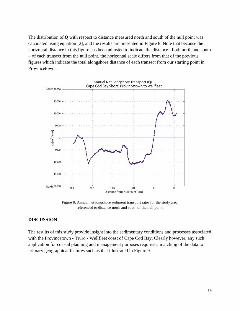
The distribution of Q with respect to distance measured north and south of the null point was
calculated using equation [2], and the results are presented in Figure 8. Note that because the
horizontal distance in this figure has been adjusted to indicate the distance - both north and south
– of each transect from the null point, the horizontal scale differs from that of the previous
figures which indicate the total alongshore distance of each transect from our starting point in
Provincetown.
Figure 8: Annual net longshore sediment transport rates for the study area,
referenced to distance north and south of the null point.
DISCUSSION
The results of this study provide insight into the sedimentary conditions and processes associated
with the Provincetown - Truro - Wellfleet coast of Cape Cod Bay. Clearly however, any such
application for coastal planning and management purposes requires a matching of the data to
primary geographical features such as that illustrated in Figure 9.

15
Figure 9: Primary coastal features within the study area matched to the distribution of annual net longshore sediment
transport rates. Letter codes, A – F, are discussed in the text.
We see from the figure that the primary sediment source area for this coast lies between Duck
Harbor and the southern end of Griffin Island in Wellfleet, designated “A” in figure 9. This
dominant sediment source acts as the null point of net transport between the closed littoral cell to
its north (“Truro” cell), and the open littoral cell (“Wellfleet” cell) to its south.
It is important to appreciate that while the data clearly indicate the absence of net longshore
transport across this region, that fact does not imply that no sediment crosses the area between
the two cells. The term “net transport” refers to the (long term) difference between total sediment
movement in either alongshore direction. The actual (“gross”) transport is the total sediment
movement in both alongshore directions. As a result of gross longshore transport, there is
sediment dispersion in the region of the null point, and in addition, since total wave energy
increases significantly in the southward direction along this coastal reach (e.g., Uchupi, et al.,
1996), sediment dispersion increases also.
The primary sediment sink for the study area lies in the region of the Truro – Provincetown
border, designated “B”. This region, too, provides a null point to net longshore transport,
separating the major cell to its south and east from the Provincetown Harbor cell to its west
( Berman, 2011).

16
While the direction of net transport everywhere within the Truro littoral cell is northward, there
are notable variations in transport rates, and associated with those variations are secondary
sources and sinks. The most significant secondary source lies offshore of the barrier beach,
Beach Point, just north of the “Knowles” region (“C” in figure 9). There, offshore deposits –
remnants of ebb shoals associated with the former East Harbor inlet – are eroding. Similarly, the
secondary source lying just north of Corn Hill (“D” in figure 9) is a remnant of deposits
associated with a former entrance to Pamet Harbor which closed during the 1938 hurricane. A
third secondary source, the bluff region between Fisher Beach and Duck Harbor (“E” in figure
9), is a continuation of the primary source to its south, interrupted by the presumably relic
deposits associated with a pre-modern tidal inlet in the vicinity of Ryder Beach (e.g., Uchupi, et
al., 1996).
The only significant secondary sediment sinks in the Truro littoral cell are those associated with
Pamet Inlet and the two barrier beaches that lie to the north and south of the inlet (“F” in figure
9). Together, these remove more than 7,000 cubic meters of sediment per year from the system.
This rate of loss from the Truro cell littoral transport system can be contrasted with its maximum
net rate of transport of approximately 12,000 cubic meters per year.
The “open” Wellfleet cell is considerably more vigorous than its Truro neighbor, reaching a
maximum net transport rate (toward the south in this case) of about 15,000 cubic meters per year
in the vicinity of Great Beach Hill. The source/sink or erosion/deposition patterns apparent at the
upper left corner of Figure 9 probably represent little more than a southward shift of temporary
deposits associated with relic imprints of past morphology offshore of the rapidly retreating coast
(e.g., Uchupi, et al., 1996).
A particularly striking characteristic of the Wellfleet cell is the highly dynamic nature of its
terminus at Jeremy Point. Despite the ephemeral appearance of this narrow feature, these data
indicate that it receives, in net, some 10,000 cubic meters of sediment each year – about the same
rate at which it exports sediment to the shoals lying to its south. Of course, total sediment loss to
the sea combined with shoreline retreat will continue to degrade this feature over time, but the
balance of sediment supply with sediment loss appears to accounts for its resiliency over the
short term.

17
ACKNOWLEDGEMENTS
The authors would like to thank the Massachusetts Bays Program for their grant to the Center for
Coastal Studies in support of this project; and Aaron Dushku, State GIS Specialist, Natural
Resource Conservation Service, United States Department of Agriculture for electronic copies of
the post hurricane1938 aerial photographs.

18
GLOSSARY OF TERMS
Term Symbol Units Description
Littoral cell
A coastal compartment that contains a complete
cycle of sedimentation including sources, transport
paths, and sinks. Cell boundaries delineate the
geographical area within which the sediment budget
is balanced, providing the framework for the
quantitative analysis of coastal erosion and accretion.
(See Berman, 2011, for full discussion.
Annual rate of change in
cross-shore area, or
Local change in cross-
shore area.
E
meters2/year, or
meters3/meter/year
Total loss or gain per year in cross-sectional area of
the “active” zone (wave transport zone) of beach at
any specific location along the shore. Equals dQ/dy +
q. (+) E = erosion; (-) E = deposition or accretion.
Annualized change in
cross section area along a
transect
dA/dt
meters2/year or
meter3/meter/year
Time (“t”) rate of change in cross-sectional area
(“A”) between two cross-shore transects at a single
location or the volume rate of coastal change per unit
shoreline distance. (Note: dA/dt = - dQ/dy – q).
Littoral drift or
(net) longshore
sediment transport
Q
meters3/year
The annual net flow of sediment along the coast
expressed as the volume rate of sediment crossing a
shore-perpendicular transect that extends across the
active coast from the landward limit of wave-
produced sediment transport seaward to the
approximate limit of sediment movement. (The result
of integration of dQ/dy along the shore).
Alongshore gradient of
annual net longshore
transport
dQ/dy
meters2/year or
meters3/meter/year
Gain or losses in area at a shore-perpendicular
transect due to longshore sediment transport.
If q = 0, erosion results when dQ/dt increases
alongshore; deposition results when dQ/dy decreases
alongshore.
Constant of integration
C
meters3/year
Constant used in the calculation of the net longshore
sediment transport (Q) for any coastal location.
C = - ∫ (dQ/dy)max dy
Net cross-shore transport
per unit shoreline
distance
q
meters2/year or
meters3/meter/year
Gain or losses in area at a shore-perpendicular
transect due to cross-shore sediment transport , e.g.,
wind-transported sand exchange between a beach
and coastal dunes, tidal inlet losses, or offshore
transport of very fine sediment by storm seas.
Null point
A point along the shore that defines the updrift or
downdrift boundary of a littoral cell. Where Q = 0,
or dQ/dy is a maximum (in the case of a source).
This point is sometimes referred to as a nodal point.

19
REFERENCES
Berman, G.A., 2011, Longshore Sediment Transport, Cape Cod, Massachusetts. Marine
Extension Bulletin, Woods Hole Sea Grant & Cape Cod Cooperative Extension. 48 p.
Byrnes, M.R., J.L. Baker and F. Li, 2002, Quantifying Potential Measurement Errors and
Uncertainties Associated with Bathymetric Change Analysis. ERDC/CHL CHETN-IV-50.
Coastal and Hydraulics Engineering Technical Note (CHETN). U.S. Army Corps of Engineers.
September 2002.
Dean, R.G., and Dalrymple, 2002, Coastal Processes with Engineering Applications. Cambridge
University Press, Cambridge, UK, 475 p.
Giese, G.S., M. Borrelli, S.T. Mague, and P. Hughes, 2013, Evaluating century-scale coastal
change: Provincetown/Truro line to Provincetown Harbor. Marine Geology Report No.13-1,
Center for Coastal Studies, Provincetown, MA, 11 p.
Giese, G.S., M. Borrelli, S.T. Mague, and P. Hughes, 2012, Evaluating century-scale coastal
change: a pilot project for the Beach Point area in Truro and Provincetown, Massachusetts.
Marine Geology Report No.12-2, Center for Coastal Studies, Provincetown, MA, 18 p.
Giese, G.S., M.B. Adams, S.S. Rogers, S.L. Dingman, M.Borrelli and T.L. Smith. 2011, Coastal
sediment transport on outer Cape Cod, Massachusetts. In P. Wang, J.D. Rosati and T. M.
Roberts (eds.) Coastal Sediments ’11, American Society of Civil Engineers, v. 3, p. 2353-2356.
Giese, G.S. and M.B. Adams. 2007, Changing orientation of ocean-facing bluffs on a
transgressive coast, Cape Cod, Massachusetts. In: Kraus, N.C., and J.D. Rosati (eds.), Coastal
Sediments ’07, American Society of Civil Engineers, v. 2, p. 1142-1152.
Jakobsson, M., A. Armstrong, B. Calder, L. Huff, L. Mayer, and L. Ward, 2005, On the Use of
Historical Bathymetric Data to Determine Changes in Bathymetry: An Analysis of Errors and
Application to Great Bay Estuary, NH. International Hydrographic Review, Vol. 6, No. 3, pps.
25-41. November 2005.
Komar, P.D., 1998, Beach Processes and Sedimentation, Second Edition. Prentice Hall, New
Jersey. 544 p.
Mague, S.T. (2012) Retracing the Past: Recovering 19th Century Benchmarks to Measure
Shoreline Change Along the Outer Shore of Cape Cod, Massachusetts. Cartography and
Geographic Information Science, Vol. 39, No. 1, pp. 30-47.
Uchupi, E., G.S. Giese, D.G. Aubrey and D.J. Kim, 1996, The Late Quaternary Construction of
Cape Cod, Massachusetts: A Reconsideration of the W.M. Davis Model. Geological Society of
America Special Paper, 309, 69 pp.

20
Van der Wal, D. and K. Pye. (2003). The use of historical bathymetric charts in a GIS to assess
morphological change in estuaries. The Geographic Journal, Vol. 169, No. 1, pps. 21-31. March
2003.
T and H-sheet Descriptive Reports
U.S. Coast and Geodetic Survey. 1933. Descriptive Report, Hydrographic Sheet No. 1, 5400.
Cape Cod, Provincetown Harbor and Vicinity. 15 pages.
U.S. Coast and Geodetic Survey. 1933. Descriptive Report, Hydrographic Sheet No. 2, 5401.
Cape Cod, Wellfleet Harbor. 38 pages.
U.S. Coast and Geodetic Survey. 1933. Descriptive Report, Hydrographic Sheet No. C, 5543.
Cape Cod, Billingsgate Shoal. 22 pages.
U.S. Coast and Geodetic Survey. 1909. Descriptive Report, Topographic Sheets 616 a & b.
Massachusetts, Cape Cod Bay. 11 pages.
U.S. Coast and Geodetic Survey. 1933. Descriptive Report, Topographic Sheets 6033& 6034.
Massachusetts, Cape Cod, Provincetown & Vicinity, Wellfleet & Vicinity. 35 pages.
U.S. Coast and Geodetic Survey. 1944. Descriptive Report, Topographic Sheets 5731.
Massachusetts, Provincetown-Race Point-Pilgrim Lake. 25 pages.
U.S. Coast and Geodetic Survey. 1944. Descriptive Report, Topographic Sheets 5732.
Massachusetts, Truro. 21 pages.
U.S. Coast and Geodetic Survey. 1944. Descriptive Report, Topographic Sheets 5733.
Massachusetts, Wellfleet-Truro-Herring River-Pamet River. 21 pages.
U.S. Coast and Geodetic Survey. 1944. Descriptive Report, Topographic Sheets 5734.
Massachusetts, Wellfleet Harbor-Atlantic Ocean. 22 pages.
U.S. Coast and Geodetic Survey. 1944. Descriptive Report, Topographic Sheets 5735.
Massachusetts, Atlantic Ocean –Cape Cod Bay, South Orleans-North Eastham. 31 pages.
Cartographic and Bathymetric Data Used in this Project
1835 - A Map of the Extremity of Cape Cod Including the Townships of Provincetown and
Truro: A Chart of Their Sea Coast and of Cape Cod Harbour, State of Massachusetts, Executed
under the Direction of Major James D. Graham, U.S. Corps of Topo. Engineers During Portions
of the Years 1833, 1834, and 1835
1848 - U.S. Coast Survey Plane Table Survey, T-616, Extremity of Cape Cod Including
Provincetown and Part of Truro. Scale 1:10,000.
21
1856 - U.S. Coast Survey Hydrographic Survey, H-578, Cape Cod Bay with Provincetown
Harbor. Scale 1:40,000.
1867 - U.S. Coast Survey Hydrographic Survey, H-2053a, Cape Cod and Provincetown Harbor.
Scale 1:10,000.
1889 - U.S. Coast & Geodetic Survey, H-1951, Sheet 5, Cross Sections North and East Shore of
Cape Cod, Mass., Highland Light to Peaked Hill Life SS, by the Party in Charge of H.L.
Marindin, Asst.” Scale 1:10,000.
1889 - U.S. Coast & Geodetic Survey, H-1952, Sheet 5, Cross Sections North and West Shore of
Cape Cod, Mass., Peaked Hill Life SS to Long Pt. Light, by the Party in Charge of H.L.
Marindin, Asst.” Scale 1:10,000.
1889 - U.S. Coast & Geodetic Survey Plane Table Survey, T-1982, High Head and Old East
Harbor, Cape Cod, Mass. Scale 1:10,000.
1890 - U.S. Coast & Geodetic Survey, H-2019, Sheet 5, Topography and Hydrography of
Provincetown Harbor, Mass., Surveyed by the Party of H.L. Marindin, Asst.” Scale 1:10,000.
1933 - U.S. Coast & Geodetic Survey Topographic Survey, T-6033, Provincetown & Vicinity,
Cape Cod, Massachusetts. Scale 1:20,000.
1933 - U.S. Coast & Geodetic Survey Topographic Survey, T-6034, Wellfleet & Vicinity, Cape
Cod, Massachusetts. Scale 1:20,000.
1933 - U.S. Coast & Geodetic Survey Hydrographic Survey, H-5400, Provincetown Harbor &
Vicinity, Cape Cod, Massachusetts. Scale 1:20,000.
1933 - U.S. Coast & Geodetic Survey Hydrographic Survey, H-5401, Wellfleet Harbor, Cape
Cod, Massachusetts. Scale 1:20,000.
1934 - U.S. Coast & Geodetic Survey Hydrographic Survey, H-5534, Billingsgate Shoal, Cape
Cod, Massachusetts. Scale 1:20,000.
1938 – U.S. Coast & Geodetic Topographic Map, T-5731, Massachusetts, Cape Cod,
Provincetown and Vicinity. Scale – 1:10,000.
1938 – U.S. Coast & Geodetic Topographic Map, T-5732, Massachusetts, Cape Cod, Truro and
Vicinity. Scale – 1:10,000.

22
1938 – U.S. Coast & Geodetic Topographic Map, T-5733, Massachusetts, Cape Cod, Wellfleet-
Truro and Vicinity. Scale – 1:10,000.
1938 – U.S. Coast & Geodetic Topographic Map, T-5734, Massachusetts, Cape Cod, Wellfleet
Harbor and Vicinity. Scale – 1:10,000.
1938 – United States Department of Agriculture, Natural Resource Conservation Service, Aerial
Photographs. Date of Photographs: November 21, 1938. Ground Scale 1:24,000. Time of
photos: ~ 1000 HRS. Time of High Water: ~ 1000 HRS. Weather: Clear, west winds 10-15 mph.
1941-1942 - U.S. Geological Survey, Provincetown, Truro, Wellfleet Quadrangles. Scale:
1:31,680.
1952 – U.S. Coast & Geodetic Shoreline Manuscript, T-11175, Massachusetts, Cape Cod Bay,
Provincetown. Scale – 1:10,000.
1952 – U.S. Coast & Geodetic Shoreline Manuscript, T-11176, Massachusetts, Cape Cod Bay,
North Truro. Scale – 1:10,000.
1952 – U.S. Coast & Geodetic Shoreline Manuscript, T-11179, Massachusetts, Cape Cod Bay,
Truro. Scale – 1:10,000.
1952 – U.S. Coast & Geodetic Shoreline Manuscript, T-11181, Massachusetts, Cape Cod Bay,
Wellfleet Harbor. Scale – 1:10,000.
1952 – U.S. Coast & Geodetic Shoreline Manuscript, T-11173, Massachusetts, Cape Cod Bay,
Eastham. Scale – 1:10,000.
1952 – U.S. Coast & Geodetic Shoreline Manuscript, T-11188, Massachusetts, Cape Cod Bay,
Quivett Creek to Boatmeadow River. Scale – 1:10,000.