assessment of the undiscovered oil and gas of the … · assessment of the undiscovered oil and gas...
TRANSCRIPT
Assessment of the Undiscovered Oil and Gas of the Senegal Province, Mauritania, Senegal, The Gambia, and Guinea-Bissau, Northwest Africa
By Michael E. Brownfield and Ronald R. Charpentier
U.S. Geological Survey Bulletin 2207–A
U.S. Department of the Interior U.S. Geological Survey
Posted online October 2003, version 1.0
Any use of trade, product, or firm names in this publication is for descriptive purposes only and does not imply endorsement by the U.S. Government.
Published in the Central Region, Denver, Colorado Manuscript approved for publication June 5, 2003
U.S. Department of the InteriorGale A. Norton, Secretary
U.S. Geological SurveyCharles G. Groat, Director
iii
ContentsForeword. . . . . . . . . . . . . . . . . . . . . . . . . . . . . . . . . . . . . . . . . . . . . . . . . . . . . . . . . . . . . . . . . . . . . . . . . . . . . . . . . . . . . . . . . . . . . . . . . . . . 1Abstract. . . . . . . . . . . . . . . . . . . . . . . . . . . . . . . . . . . . . . . . . . . . . . . . . . . . . . . . . . . . . . . . . . . . . . . . . . . . . . . . . . . . . . . . . . . . . . . . . . . . . 2Introduction . . . . . . . . . . . . . . . . . . . . . . . . . . . . . . . . . . . . . . . . . . . . . . . . . . . . . . . . . . . . . . . . . . . . . . . . . . . . . . . . . . . . . . . . . . . . . . . . . 2Senegal Basin Geology. . . . . . . . . . . . . . . . . . . . . . . . . . . . . . . . . . . . . . . . . . . . . . . . . . . . . . . . . . . . . . . . . . . . . . . . . . . . . . . . . . . . . . 3
Pre-rift Section. . . . . . . . . . . . . . . . . . . . . . . . . . . . . . . . . . . . . . . . . . . . . . . . . . . . . . . . . . . . . . . . . . . . . . . . . . . . . . . . . . . . . . . . 4Syn-rift Section. . . . . . . . . . . . . . . . . . . . . . . . . . . . . . . . . . . . . . . . . . . . . . . . . . . . . . . . . . . . . . . . . . . . . . . . . . . . . . . . . . . . . . . . 7Post-rift Section . . . . . . . . . . . . . . . . . . . . . . . . . . . . . . . . . . . . . . . . . . . . . . . . . . . . . . . . . . . . . . . . . . . . . . . . . . . . . . . . . . . . . . 12
Petroleum Occurrence in the Senegal Basin. . . . . . . . . . . . . . . . . . . . . . . . . . . . . . . . . . . . . . . . . . . . . . . . . . . . . . . . . . . . . . . . 12Hydrocarbon Source Rocks in the Senegal Basin . . . . . . . . . . . . . . . . . . . . . . . . . . . . . . . . . . . . . . . . . . . . . . . . . . . . 12Hydrocarbon Generation and Migration in the Senegal Province . . . . . . . . . . . . . . . . . . . . . . . . . . . . . . . . . . . . . 14Hydrocarbon Reservoirs, Traps, and Seals in the Senegal Basin . . . . . . . . . . . . . . . . . . . . . . . . . . . . . . . . . . . . . . 19
Total Petroleum Systems of the Senegal Province. . . . . . . . . . . . . . . . . . . . . . . . . . . . . . . . . . . . . . . . . . . . . . . . . . . . . . . . . . . 19Lower Paleozoic and Sub-salt Total Petroleum Systems . . . . . . . . . . . . . . . . . . . . . . . . . . . . . . . . . . . . . . . . . . . . . . 19Cretaceous-Tertiary Composite Total Petroleum System . . . . . . . . . . . . . . . . . . . . . . . . . . . . . . . . . . . . . . . . . . . . . . 23Coastal Plain and Offshore Assessment Unit. . . . . . . . . . . . . . . . . . . . . . . . . . . . . . . . . . . . . . . . . . . . . . . . . . . . . . . . . . 23
Summary. . . . . . . . . . . . . . . . . . . . . . . . . . . . . . . . . . . . . . . . . . . . . . . . . . . . . . . . . . . . . . . . . . . . . . . . . . . . . . . . . . . . . . . . . . . . . . . . . . . 24References Cited. . . . . . . . . . . . . . . . . . . . . . . . . . . . . . . . . . . . . . . . . . . . . . . . . . . . . . . . . . . . . . . . . . . . . . . . . . . . . . . . . . . . . . . . . . . 24
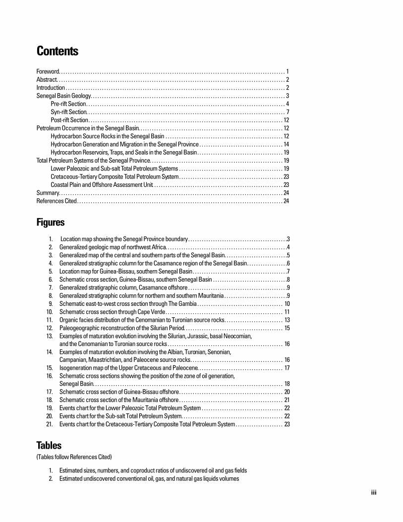
Figures1. Location map showing the Senegal Province boundary. . . . . . . . . . . . . . . . . . . . . . . . . . . . . . . . . . . . . . . . . . . .32. Generalized geologic map of northwest Africa. . . . . . . . . . . . . . . . . . . . . . . . . . . . . . . . . . . . . . . . . . . . . . . . . . . . . .43. Generalized map of the central and southern parts of the Senegal Basin. . . . . . . . . . . . . . . . . . . . . . . . . . . .54. Generalized stratigraphic column for the Casamance region of the Senegal Basin. . . . . . . . . . . . . . . . . .65. Location map for Guinea-Bissau, southern Senegal Basin. . . . . . . . . . . . . . . . . . . . . . . . . . . . . . . . . . . . . . . . . .76. Schematic cross section, Guinea-Bissau, southern Senegal Basin . . . . . . . . . . . . . . . . . . . . . . . . . . . . . . . . .87. Generalized stratigraphic column, Casamance offshore . . . . . . . . . . . . . . . . . . . . . . . . . . . . . . . . . . . . . . . . . . . .98. Generalized stratigraphic column for northern and southern Mauritania. . . . . . . . . . . . . . . . . . . . . . . . . . . .99. Schematic east-to-west cross section through The Gambia. . . . . . . . . . . . . . . . . . . . . . . . . . . . . . . . . . . . . . 10
10. Schematic cross section through Cape Verde. . . . . . . . . . . . . . . . . . . . . . . . . . . . . . . . . . . . . . . . . . . . . . . . . . . . 1111. Organic facies distribution of the Cenomanian to Turonian source rocks. . . . . . . . . . . . . . . . . . . . . . . . . . 1312. Paleogeographic reconstruction of the Silurian Period. . . . . . . . . . . . . . . . . . . . . . . . . . . . . . . . . . . . . . . . . . . . 1513. Examples of maturation evolution involving the Silurian, Jurassic, basal Neocomian,
and the Cenomanian to Turonian source rocks . . . . . . . . . . . . . . . . . . . . . . . . . . . . . . . . . . . . . . . . . . . . . . . . . . . 1614. Examples of maturation evolution involving the Albian, Turonian, Senonian,
Campanian, Maastrichtian, and Paleocene source rocks. . . . . . . . . . . . . . . . . . . . . . . . . . . . . . . . . . . . . . . . . 1615. Isogeneration map of the Upper Cretaceous and Paleocene. . . . . . . . . . . . . . . . . . . . . . . . . . . . . . . . . . . . . . 1716. Schematic cross sections showing the position of the zone of oil generation,
Senegal Basin. . . . . . . . . . . . . . . . . . . . . . . . . . . . . . . . . . . . . . . . . . . . . . . . . . . . . . . . . . . . . . . . . . . . . . . . . . . . . . . . . . . . 1817. Schematic cross section of Guinea-Bissau offshore. . . . . . . . . . . . . . . . . . . . . . . . . . . . . . . . . . . . . . . . . . . . . . 2018. Schematic cross section of the Mauritania offshore. . . . . . . . . . . . . . . . . . . . . . . . . . . . . . . . . . . . . . . . . . . . . . 2119. Events chart for the Lower Paleozoic Total Petroleum System . . . . . . . . . . . . . . . . . . . . . . . . . . . . . . . . . . . . 2220. Events chart for the Sub-salt Total Petroleum System. . . . . . . . . . . . . . . . . . . . . . . . . . . . . . . . . . . . . . . . . . . . . 2221. Events chart for the Cretaceous-Tertiary Composite Total Petroleum System . . . . . . . . . . . . . . . . . . . . . 23
Tables(Tables follow References Cited)
1. Estimated sizes, numbers, and coproduct ratios of undiscovered oil and gas fields2. Estimated undiscovered conventional oil, gas, and natural gas liquids volumes
1
Assessment of the Undiscovered Oil and Gas of the Senegal Province, Mauritania, Senegal, The Gambia, and Guinea-Bissau, Northwest Africa
By Michael E. Brownfield and Ronald R. Charpentier
Foreword
This report was prepared as part of the World Petroleum Assessment 2000 of the U.S. Geological Survey’s Energy Resources Program. The purpose of the World Petroleum Assessment 2000 is to assess the quantities of oil, gas, and nat-ural gas liquids that have the potential to be added to reserves within the next 30 years. These volumes either reside in undis-covered fields whose sizes exceed the minimum-field-size cut-off value of at least 1 million barrels of oil equivalent, or occur as reserve growth of fields already discovered.
In order to organize, evaluate, and delineate areas to assess, a hierarchical scheme of geographic and geologic units was developed. This scheme consists of regions, geologic prov-inces, petroleum systems, and assessment units. In the World Petroleum Assessment 2000, regions serve as organizational units and geologic provinces are used as prioritization tools.
The project divided the world into 8 regions and 937 geo-logic provinces. Provinces were ranked according to the discov-ered oil and gas volumes within each (Klett and others, 1997; Klett and others, 2000a). Seventy-six “priority” provinces (exclusive of the United States and chosen for their high rank-ing) and 26 “boutique” provinces (exclusive of the United States and chosen for their anticipated petroleum richness or special regional economic or strategic importance) were selected for appraisal of oil and gas resources.
A geologic province is an area that characteristically has dimensions of hundreds of kilometers and that encompasses a natural geologic entity (for example, sedimentary basin, thrust belt, accreted terrain) or some combination of contiguous geo-logic entities. Province boundaries were drawn as logically as possible along natural geologic boundaries, although in some places their location is based on other factors such as a specific bathymetric depth in open oceans.
Total petroleum systems and assessment units are delin-eated within each of the geologic provinces assessed for undis-covered oil and gas. Although the boundaries of total petroleum systems and assessment units are usually contained within a geologic province, it is not required. The petroleum system con-cept emphasizes the similarities in oil composition (Magoon and Dow, 1994), unlike geologic provinces and plays that
emphasize similarities in the rocks. The mapped area of the total petroleum system, as defined for this study, includes all geneti-cally related petroleum that occurs in seeps, shows, and accu-mulations (discovered and undiscovered) generated by a pod or by closely related pods of mature source rock (Klett and others, 2000b). The area also includes the essential geologic elements (that is, reservoirs, seals, traps, and overburden rocks) that con-trol the fundamental processes of petroleum generation, expul-sion, migration, entrapment, and preservation. The “minimum” petroleum system is that part of a total petroleum system encompassing discovered shows, seeps, and accumulations together with the geologic space in which the various essential elements have been proved by these discoveries.
An assessment unit is a mappable portion of a total petro-leum system in which discovered and undiscovered fields con-stitute a single, relatively homogeneous population. The meth-odology of our resource assessment is based on the probability of number and size of undiscovered fields and, therefore, is sen-sitive to the homogeneity of each population being assessed.
A total petroleum system might equate to a single assess-ment unit or, if necessary, may be subdivided into two or more assessment units such that each assessment unit is sufficiently homogeneous in terms of geology, exploration considerations, and risk to assess individually. Heterogeneity cannot be allevi-ated in all assessment units. In such cases, accumulation density and exploration concepts are not extrapolated across the entire assessment unit.
A numeric code identifies each region, province, total petroleum system, and assessment unit; these codes are uniform throughout the project and throughout all publications of the project. The code used in this study is as follows:
The codes for the regions and provinces are listed in Klett and others (1997, 2000a).
Unit Name Code
Region Sub-Saharan Africa 7Province Senegal Basin 7013
Total petroleum system Cretaceous-Tertiary Composite 701301
Assessment unit Coastal Plain and Offshore 70130101
2 Assessment of the Undiscovered Oil and Gas of Northwest Africa
Known oil and gas volumes quoted in this report are derived from Petroconsultants, Inc., 1996 Petroleum Exploration and Production database (Petroconsultants, 1996) and other area reports from Petroconsultants, Inc., unless other-wise noted. Increases in reported estimated total recoverable vol-umes are commonly observed from year to year. To address this phenomenon, the U.S. Geological Survey created a “reserve-growth” model. When applicable, this model is applied to the reported data, and the resulting “grown” data rather than the “known” data are used in the assessment process.
Figures in this report that show boundaries of the total petroleum system and assessment unit were compiled using geographic information system (GIS) software. Political boundaries and cartographic representations were taken, with permission, from the Environmental Systems Research Institute ArcWorld 1:3 million digital coverage (Environmental Systems Research Institute, 1992). These boundaries are not politically definitive and are displayed for general reference only. Oil and gas field center points, shown in these figures, are reproduced, with permission, from Petroconsultants (1996).
Abstract
Undiscovered, conventional oil and gas resources were assessed in the Senegal Province as part of the U.S. Geological Survey World Petroleum Assessment 2000 (U.S. Geological Survey World Energy Assessment Team, 2000). Although several total petroleum systems may exist in the province, only one composite total petroleum system, the Cretaceous-Tertiary Composite Total Petroleum System, was defined with one assessment unit, the Coastal Plain and Offshore Assessment Unit, having sufficient data to allow quantitative assessment.
The primary source rocks for the Cretaceous-Tertiary Composite Total Petroleum System are the Cenomanian-Turonian marine shales. The Turonian shales can be as much as 150 meters thick and contain Type II organic carbon ranging from 3 to 10 weight percent. In the Senegal Province, source rocks are mature even when situated at depths relatively shal-low for continental passive margin basins. Reservoir rocks con-sist of Upper Cretaceous sandstones and lower Tertiary clastic and carbonate rocks. The Lower Cretaceous platform carbonate rocks (sealed by Cenomanian shales) have porosities ranging from 10 to 23 percent. Oligocene carbonate rock reservoirs exist, such as the Dome Flore field, which contains as much as 1 billion barrels of heavy oil (10° API, 1.6 percent sulfur) in place. The traps are a combination of structural closures and stratigraphic pinch-outs.
Hydrocarbon production in the Senegal Province to date has been limited to several small oil and gas fields around Cape Verde (also known as the Dakar Peninsula) from Upper Cretaceous sandstone reservoirs bounded by normal faults, of
which three fields (two gas and one oil) exceed the minimum size assessed in this study (1 MMBO; 6 BCFG). Discovered known oil resources in the Senegal Province are 10 MMBO, with known gas resources of 49 BCFG (Petroconsultants, 1996).
This study estimates that 10 percent of the total number of potential oil and gas fields (both discovered and undiscovered) of at least the minimum size have been discovered. The esti-mated mean size and number of assessed, undiscovered oil fields are 13 MMBO and 13 fields, respectively, whereas the mean size and number of undiscovered gas fields are estimated to be 50 BCFG and 11 fields.
The mean estimates for undiscovered conventional petro-leum resources are 157 MMBO, 856 BCFG, and 43 MMBNGL (table 2). The mean sizes of the largest anticipated undiscovered oil and gas fields are 66 MMBO and 208 BCFG, respectively.
The Senegal Province is underexplored considering its large size. The province has hydrocarbon potential in both the offshore and onshore, and undiscovered gas resources may be significant and accessible in areas where the zone of oil gener-ation is relatively shallow.
Introduction
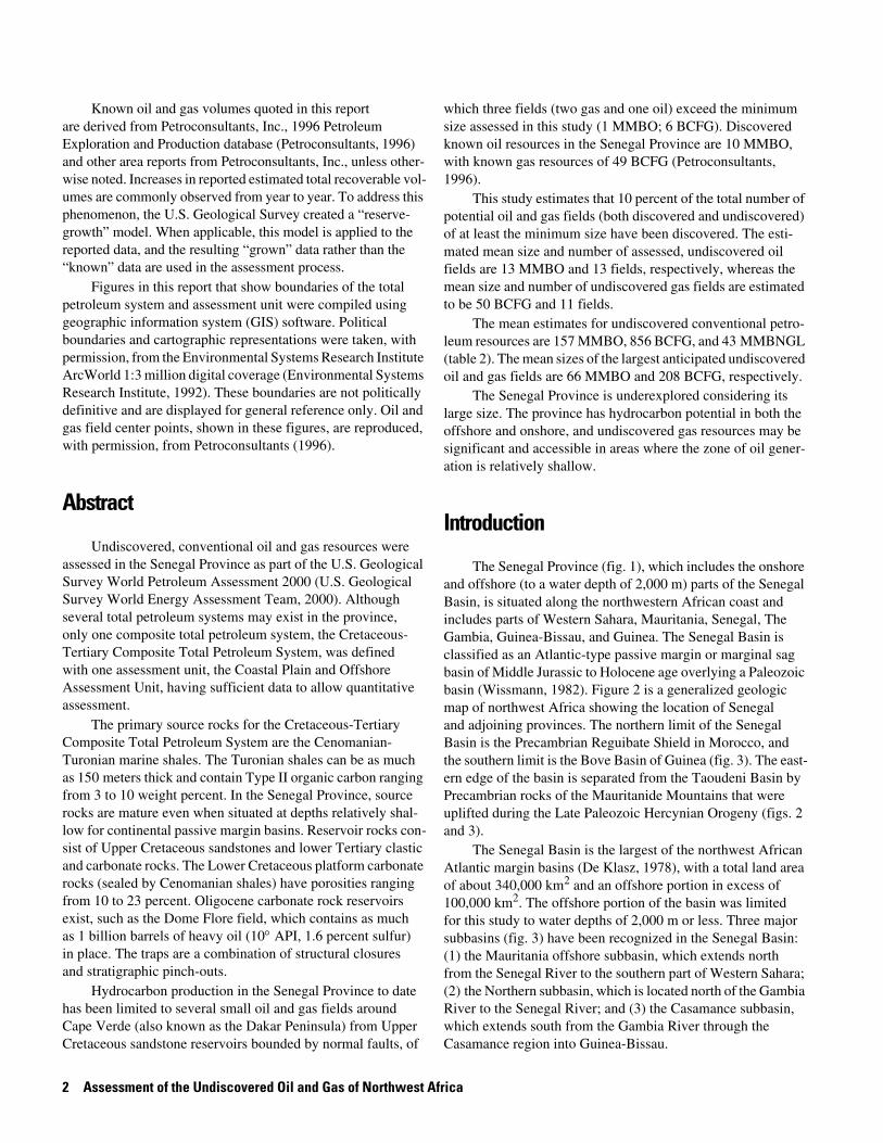
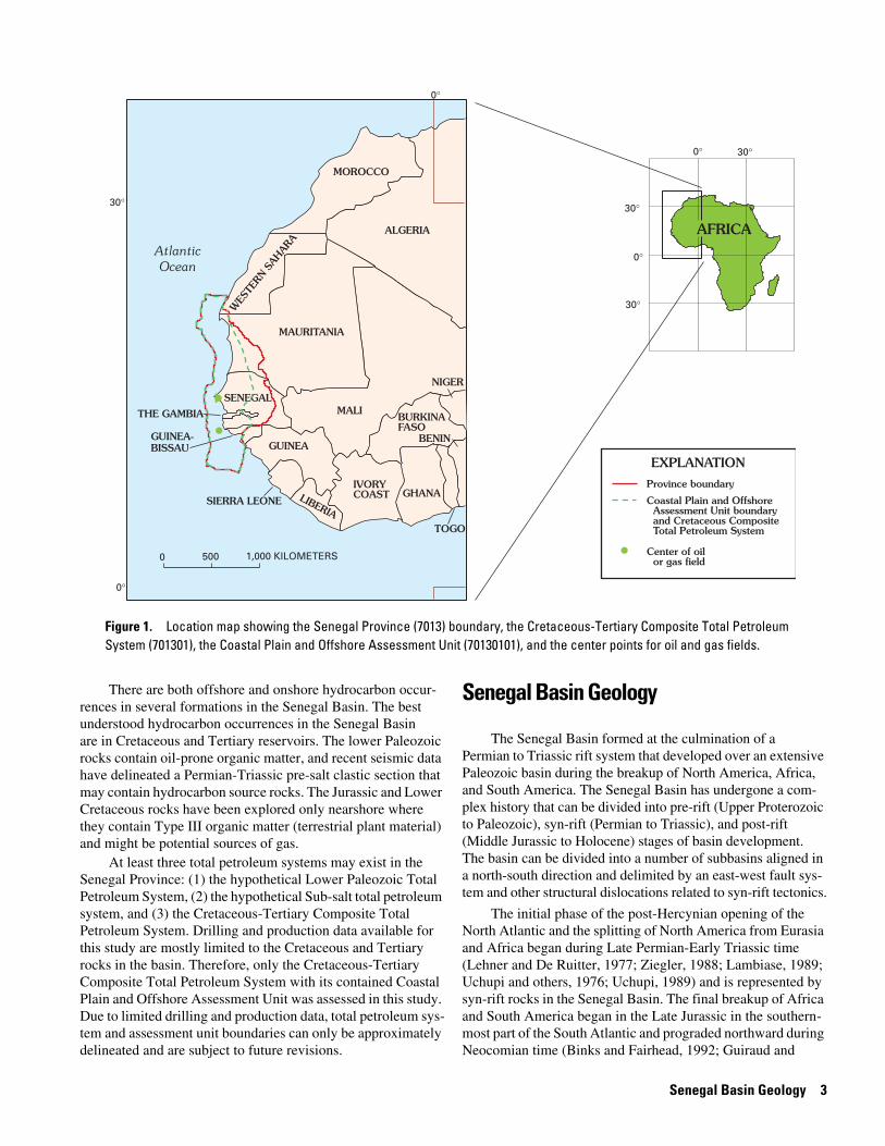
The Senegal Province (fig. 1), which includes the onshore and offshore (to a water depth of 2,000 m) parts of the Senegal Basin, is situated along the northwestern African coast and includes parts of Western Sahara, Mauritania, Senegal, The Gambia, Guinea-Bissau, and Guinea. The Senegal Basin is classified as an Atlantic-type passive margin or marginal sag basin of Middle Jurassic to Holocene age overlying a Paleozoic basin (Wissmann, 1982). Figure 2 is a generalized geologic map of northwest Africa showing the location of Senegal and adjoining provinces. The northern limit of the Senegal Basin is the Precambrian Reguibate Shield in Morocco, and the southern limit is the Bove Basin of Guinea (fig. 3). The east-ern edge of the basin is separated from the Taoudeni Basin by Precambrian rocks of the Mauritanide Mountains that were uplifted during the Late Paleozoic Hercynian Orogeny (figs. 2 and 3).
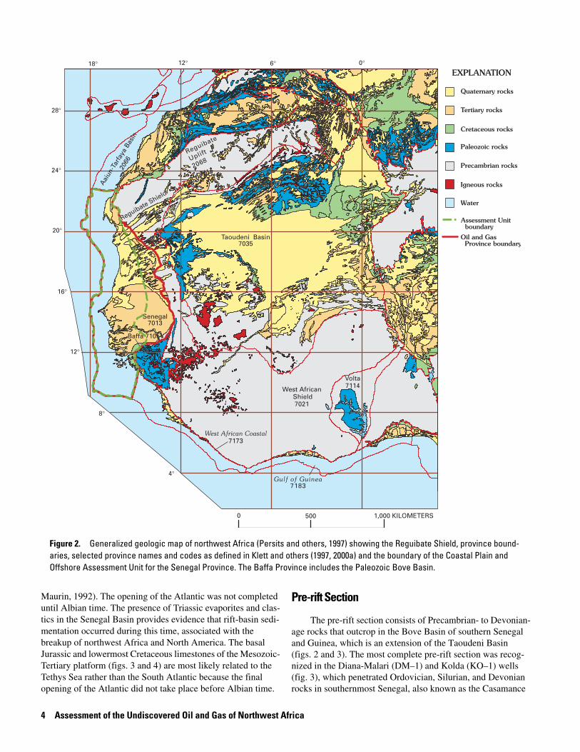
The Senegal Basin is the largest of the northwest African Atlantic margin basins (De Klasz, 1978), with a total land area of about 340,000 km2 and an offshore portion in excess of 100,000 km2. The offshore portion of the basin was limited for this study to water depths of 2,000 m or less. Three major subbasins (fig. 3) have been recognized in the Senegal Basin: (1) the Mauritania offshore subbasin, which extends north from the Senegal River to the southern part of Western Sahara; (2) the Northern subbasin, which is located north of the Gambia River to the Senegal River; and (3) the Casamance subbasin, which extends south from the Gambia River through the Casamance region into Guinea-Bissau.
Senegal Basin Geology 3
There are both offshore and onshore hydrocarbon occur-rences in several formations in the Senegal Basin. The best understood hydrocarbon occurrences in the Senegal Basin are in Cretaceous and Tertiary reservoirs. The lower Paleozoic rocks contain oil-prone organic matter, and recent seismic data have delineated a Permian-Triassic pre-salt clastic section that may contain hydrocarbon source rocks. The Jurassic and Lower Cretaceous rocks have been explored only nearshore where they contain Type III organic matter (terrestrial plant material) and might be potential sources of gas.
At least three total petroleum systems may exist in the Senegal Province: (1) the hypothetical Lower Paleozoic Total Petroleum System, (2) the hypothetical Sub-salt total petroleum system, and (3) the Cretaceous-Tertiary Composite Total Petroleum System. Drilling and production data available for this study are mostly limited to the Cretaceous and Tertiary rocks in the basin. Therefore, only the Cretaceous-Tertiary Composite Total Petroleum System with its contained Coastal Plain and Offshore Assessment Unit was assessed in this study. Due to limited drilling and production data, total petroleum sys-tem and assessment unit boundaries can only be approximately delineated and are subject to future revisions.
Senegal Basin Geology
The Senegal Basin formed at the culmination of a Permian to Triassic rift system that developed over an extensive Paleozoic basin during the breakup of North America, Africa, and South America. The Senegal Basin has undergone a com-plex history that can be divided into pre-rift (Upper Proterozoic to Paleozoic), syn-rift (Permian to Triassic), and post-rift (Middle Jurassic to Holocene) stages of basin development. The basin can be divided into a number of subbasins aligned in a north-south direction and delimited by an east-west fault sys-tem and other structural dislocations related to syn-rift tectonics.
The initial phase of the post-Hercynian opening of the North Atlantic and the splitting of North America from Eurasia and Africa began during Late Permian-Early Triassic time (Lehner and De Ruitter, 1977; Ziegler, 1988; Lambiase, 1989; Uchupi and others, 1976; Uchupi, 1989) and is represented by syn-rift rocks in the Senegal Basin. The final breakup of Africa and South America began in the Late Jurassic in the southern-most part of the South Atlantic and prograded northward during Neocomian time (Binks and Fairhead, 1992; Guiraud and
0°
0°
30°
30°
30°
0 500 1,000 KILOMETERS
BURKINAFASO
MAURITANIA
IVORY COASTLIBERIA
SIERRA LEONE
GUINEAGUINEA-BISSAU
THE GAMBIA
GHANA
MALI
NIGER
SENEGAL
WES
TERN
SAH
ARA
TOGO
BENIN
AtlanticOcean
�
Province boundary
Coastal Plain and Offshore Assessment Unit boundary and Cretaceous Composite Total Petroleum System
Center of oil or gas field
EXPLANATION
MOROCCO
ALGERIA AFRICA
30°
0°
0°
ll�
�
Figure 1. Location map showing the Senegal Province (7013) boundary, the Cretaceous-Tertiary Composite Total Petroleum System (701301), the Coastal Plain and Offshore Assessment Unit (70130101), and the center points for oil and gas fields.
4 Assessment of the Undiscovered Oil and Gas of Northwest Africa
Maurin, 1992). The opening of the Atlantic was not completed until Albian time. The presence of Triassic evaporites and clas-tics in the Senegal Basin provides evidence that rift-basin sedi-mentation occurred during this time, associated with the breakup of northwest Africa and North America. The basal Jurassic and lowermost Cretaceous limestones of the Mesozoic-Tertiary platform (figs. 3 and 4) are most likely related to the Tethys Sea rather than the South Atlantic because the final opening of the Atlantic did not take place before Albian time.
Pre-rift Section
The pre-rift section consists of Precambrian- to Devonian-age rocks that outcrop in the Bove Basin of southern Senegal and Guinea, which is an extension of the Taoudeni Basin (figs. 2 and 3). The most complete pre-rift section was recog-nized in the Diana-Malari (DM–1) and Kolda (KO–1) wells (fig. 3), which penetrated Ordovician, Silurian, and Devonian rocks in southernmost Senegal, also known as the Casamance
Taoudeni Basin7035
Senegal7013
12°
8°
4°
16°
20°
24°
28°
18° 12° 6° 0°
West African Shield7021
Baffa 7105
Reguibate Shield
Aai
un-T
arfa
ya B
asin
2066
West African Coastal7173
Gulf of Guinea7183
Reguibate
Uplift
2068
Volta7114
0 500 1,000 KILOMETERS
Quaternary rocks
Tertiary rocks
Cretaceous rocks
Paleozoic rocks
Precambrian rocks
Igneous rocks
Water
Oil and Gas Province boundary
Assessment Unit boundary
EXPLANATION
Figure 2. Generalized geologic map of northwest Africa (Persits and others, 1997) showing the Reguibate Shield, province bound-aries, selected province names and codes as defined in Klett and others (1997, 2000a) and the boundary of the Coastal Plain and Offshore Assessment Unit for the Senegal Province. The Baffa Province includes the Paleozoic Bove Basin.
Senegal Basin G
eology
5
?
?
0 100 KILOMETERS
21° 19° 17° 13°
13°
15°
17°
DSPD 368
SenghorSeamount
Cape VerdeSeamount
DSDP 367
DSDP 367
Saltbasin
Mes
ozoi
cC
arbo
nate
She
lf Ed
ge
M A U R I TA N I A
AT L A N T I C
O C E A N
Dakar
LIMIT
OF
PRO
SP
EC
TIVEA
RE
A
2-SEC
ON
DS
EDIM
ENT
ISOPA
CH
Dome Flore
Salt basin
THE GAMBIA
Bove Basin(Paleozoic)
Basem
ent
at4,00
0m
eters
Basement
Mauritanide M
ountains
Basem
ent at 1,000m
etersS E N E G A L
CAPE VERDE
Gambia River
Casamancesubbasin
Northernsubbasin
SENEGAL-CASAMANCEDM-1 KO-1
Bissau
15°
Mauritaniasubbasin
Approximate2,000-meterbathymetriccontour
Approximate200-meterbathymetriccontour
G U I N E A - B I S S A U
Mesozoic shelf edge— approximate 200-meter bathymetric contour
Province boundary— approximately located
Graben
Country boundary
Onshore part of the Senegal Basin
Salt dome
DM-1 Oil and gas exploration drill hole and number
Subbasin boundary— approximately located
Deep sea drilling project drill hole and number
EXPLANATION
Senegal
Casam ance R
River
Figure 3. A generalized map of the central and southern parts of the Senegal Basin showing part of the Senegal Province, the Mauritania, Northern, and Casamance sub-basins, the Mesozoic shelf edge, the northern and southern salt basins, the Mauritanide Mountains, the Bove Basin, the Deep Sea Drilling Project sites 367 and 368, the 2-second sediment isopach, and the onshore depth to basement isopachs. Also shown are the appropriate locations of the Diana-Malari (DM–1) and Kolda (KO–1) wells that penetrated the Silurian source rocks (Buba Shale). Brick pattern delineates the Mesozoic carbonate rock platform. Modified from Bungener and Hinz (1995).
6 Assessment of the Undiscovered Oil and Gas of Northwest Africa
Stratigraphy Lithology Description
Th
ickn
ess
(met
ers)
Cre
tace
ou
s
Low
erU
pp
er
Mes
ozo
icP
aleo
zoic
Precambrian undifferentiated Metamorphic rocks
Cambrian
Ordovician
Silurian
Devonian
Triassic
Jurassic
Limestone -claystone-sandstone
Limestone-marls, shales*
Sandstone
Shale/sandstone
Bituminous shales*
Shales/siltstone/sandstone
Limestone/shales/sandstone
Limestone/siltstone/sandstone
Limestone/shales/evaporites
Anhydrite
Massive salt
Gabu Sandstone
Pirada Shale
Cantari Shale
Caium Sandstone
Buba Shale*
Bafata ShaleCusselinta Sandstone
Clastics and lacustrine shales?*
Neocomian
Aptian
Albian
Cenomanian
Turonian
Senonian
Maastrichtian
Shales/sandy shales*
Cen
ozo
ic
Tert
iary
OliogoceneEocene
Miocene
Paleocene
600
300150
150
300200
900
600
650
1,100
500
2,000
2,000
300150400
1,400
400
500
350
Totalpetroleum
system
Cre
tace
ou
s-Te
rtia
ry C
om
po
site
Su
b-s
alt
(hyp
oth
etic
al)
Low
er P
aleo
zoic
(hyp
oth
etic
al)
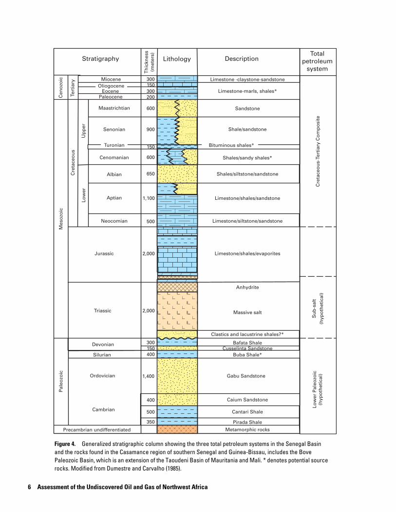
Figure 4. Generalized stratigraphic column showing the three total petroleum systems in the Senegal Basin and the rocks found in the Casamance region of southern Senegal and Guinea-Bissau, includes the Bove Paleozoic Basin, which is an extension of the Taoudeni Basin of Mauritania and Mali. * denotes potential source rocks. Modified from Dumestre and Carvalho (1985).
Senegal Basin Geology 7
subbasin. The Cambrian rocks are known only from outcrops in the Bove Basin. The pre-rift section might be as much as 3,500 m thick in the Bove Basin, whereas over 5,000 m of pre-Mesozoic rocks are interpreted from seismic data in the deeper offshore part of the Senegal Basin (Hinz and Martin, 1995). The Precambrian basement consists of metamorphic rocks of unknown thickness (fig. 4). The Cambrian sedimentary sec-tion is as much as 1,250 m thick and contains three units: the Pirada Shale, the Cantari Shale, and the Caium Sandstone. The Ordovician Gabu Sandstone attains a maximum thickness of 1,400 m. The Silurian section contains the graptolitic Buba Shale source rocks, which are as much as 400 m thick. The Devonian rocks are widespread and are the youngest Paleozoic rocks known in the basin. The Lower Devonian consists of the Cusselinta Sandstone, a 150-m-thick unit, and the Middle and Upper Devonian are represented by the 300-m-thick Bafata Shale. The section is known to occur under much of the south-ern one-half part of the basin (south of the Mauritanian border).
Two main tectonic regimes have been recognized in the Paleozoic pre-rift part of the Senegal Basin. An extensional system is defined south and east of the Casamance subbasin and south of Cape Verde (fig. 3) in which a pre-Hercynian structural
style of horsts and grabens and tilted blocks was preserved, and a compressional regime has been defined in the central and northern parts of the basin resulting from the combined effect of Caledonian and Hercynian orogenies (figs. 5 and 6).
Syn-rift Section
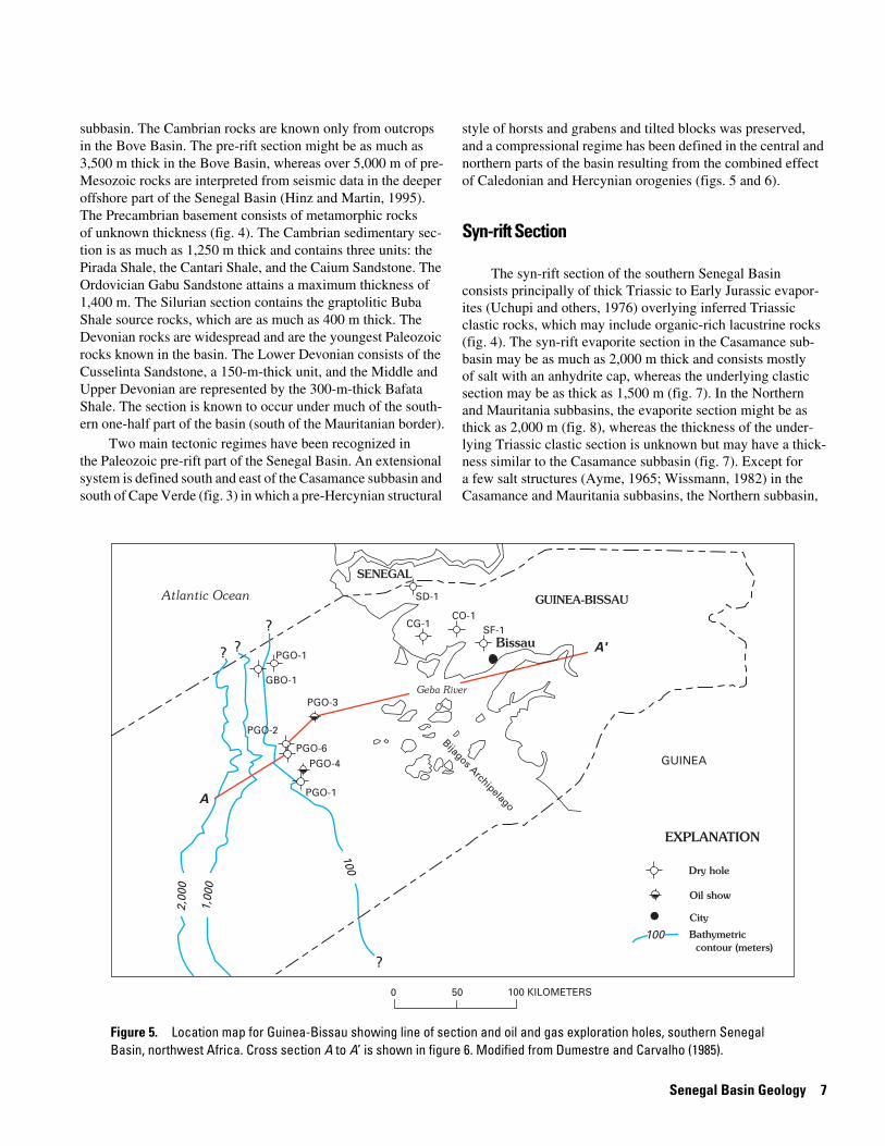
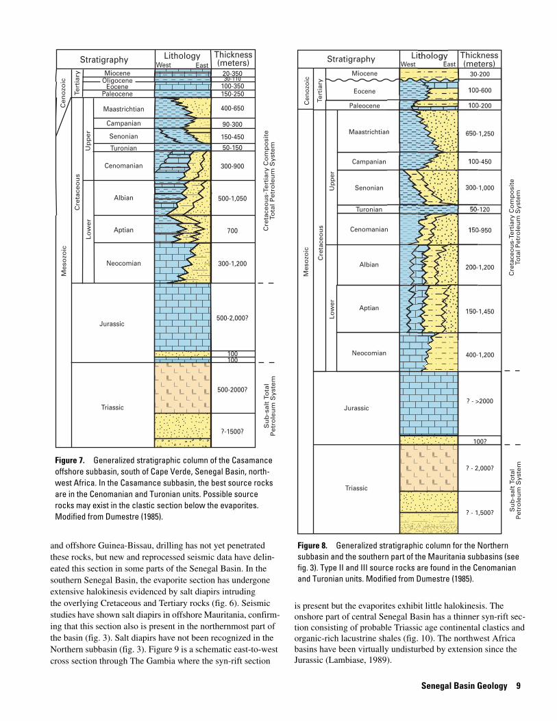
The syn-rift section of the southern Senegal Basin consists principally of thick Triassic to Early Jurassic evapor-ites (Uchupi and others, 1976) overlying inferred Triassic clastic rocks, which may include organic-rich lacustrine rocks (fig. 4). The syn-rift evaporite section in the Casamance sub- basin may be as much as 2,000 m thick and consists mostly of salt with an anhydrite cap, whereas the underlying clastic section may be as thick as 1,500 m (fig. 7). In the Northern and Mauritania subbasins, the evaporite section might be as thick as 2,000 m (fig. 8), whereas the thickness of the under- lying Triassic clastic section is unknown but may have a thick-ness similar to the Casamance subbasin (fig. 7). Except for a few salt structures (Ayme, 1965; Wissmann, 1982) in the Casamance and Mauritania subbasins, the Northern subbasin,
GUINEA-BISSAU
GUINEA
0 50 100 KILOMETERS
Atlantic Ocean
SENEGAL
SD-1
CG-1CO-1
SF-1
PGO-1
PGO-4
PGO-6
PGO-3
PGO-2
GBO-1
PGO-1
?
?
??
Bijagos Archipelago
Geba River
Bissau
100
1,00
0
2,00
0
A
A'
Dry hole
Oil show
City
Bathymetric contour (meters)
100
EXPLANATION
Figure 5. Location map for Guinea-Bissau showing line of section and oil and gas exploration holes, southern Senegal Basin, northwest Africa. Cross section A to A’ is shown in figure 6. Modified from Dumestre and Carvalho (1985).
8 A
ssessment of the U
ndiscovered Oil and G
as of Northw
est Africa
EXPLANATION? ?
Sea level
Deep outercontinental shelf
Shallow innercontinental shelf
Onshore wells projected
Mouth of Geba RiverNESW
2,000
4,000
6,000
8,000
10,000
12,000
AtlanticOcean
Tertiary
Triassic saltTriassic
salt
?
Permo - Triassic clasti
cs?
Oligocene-Miocene
Paleocene-EoceneSenonian
Cenomanian-Turonian
Aptian-Albian
NeocomianNeocomian
Neocomian
Jurassic
Jurassic
Jurassic
Unconfo
rmity
-Pale
ozoic
surfa
ce
Cambrian
Cambrian
Infra-Cambrian and Precambrian
Devonian
Ordovician
Silurian
Bijagos archipelago
PETROLEUM GEOLOGY
Potential source rock
Clastic reservoir facies
Carbonate reservoir facies
Zone of oil generation
Oil migration pathway
Paleozoic clastics
PGO-6 PGO-2 PGO-3 CG-1 CO-1 SF-1
A A'
METERS
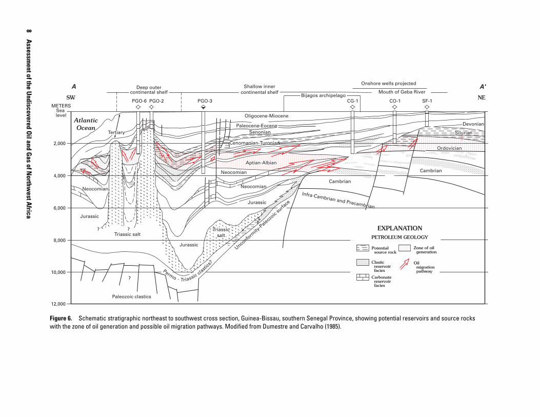
Figure 6. Schematic stratigraphic northeast to southwest cross section, Guinea-Bissau, southern Senegal Province, showing potential reservoirs and source rocks with the zone of oil generation and possible oil migration pathways. Modified from Dumestre and Carvalho (1985).
Senegal Basin Geology 9
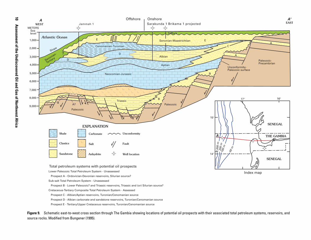
and offshore Guinea-Bissau, drilling has not yet penetrated these rocks, but new and reprocessed seismic data have delin-eated this section in some parts of the Senegal Basin. In the southern Senegal Basin, the evaporite section has undergone extensive halokinesis evidenced by salt diapirs intruding the overlying Cretaceous and Tertiary rocks (fig. 6). Seismic studies have shown salt diapirs in offshore Mauritania, confirm-ing that this section also is present in the northernmost part of the basin (fig. 3). Salt diapirs have not been recognized in the Northern subbasin (fig. 3). Figure 9 is a schematic east-to-west cross section through The Gambia where the syn-rift section
Lithology Thickness(meters)
400-650
90-300
150-450
50-150
300-900
500-1,050
700
300-1,200
500-2,000?
100100
500-2000?
?-1500?
150-250100-350
30-110
Stratigraphy
Cre
tace
ou
s-Te
rtia
ry C
om
po
site
Tota
l P
etr
ole
um
Syst
em
Su
b-s
alt
To
tal
Petr
ole
um
Syst
em
West EastC
en
ozo
ic
20-350
Cenomanian
Albian
Aptian
Neocomian
Jurassic
Triassic
Meso
zoic
Cre
tace
ou
s
Lo
wer
Up
per
Tert
iary
Senonian
Campanian
Maastrichtian
Turonian
PaleoceneEocene
MioceneOligocene
Figure 7. Generalized stratigraphic column of the Casamance offshore subbasin, south of Cape Verde, Senegal Basin, north-west Africa. In the Casamance subbasin, the best source rocks are in the Cenomanian and Turonian units. Possible source rocks may exist in the clastic section below the evaporites. Modified from Dumestre (1985).
Jurassic
Neocomian
Aptian
Albian
Cenomanian
Turonian
Senonian
Campanian
Maastrichtian
Paleocene
Eocene
Miocene
Cre
tace
ou
s
Up
per
Low
er
Mes
ozo
ic
Tert
iary
Cen
ozo
ic
Stratigraphy
? - >2000
100?
Triassic
? - 2,000?
? - 1,500?C
reta
ceo
us-
Tert
iary
Co
mp
osi
teTo
tal P
etro
leu
m S
yste
mS
ub
-sal
t To
tal
Pet
role
um
Sys
tem
Lithology Thickness(meters)
30-200
100-600
100-200
650-1,250
100-450
300-1,000
50-120
150-950
200-1,200
150-1,450
400-1,200
West East
Figure 8. Generalized stratigraphic column for the Northern subbasin and the southern part of the Mauritania subbasins (see fig. 3). Type II and III source rocks are found in the Cenomanian and Turonian units. Modified from Dumestre (1985).
is present but the evaporites exhibit little halokinesis. The onshore part of central Senegal Basin has a thinner syn-rift sec-tion consisting of probable Triassic age continental clastics and organic-rich lacustrine shales (fig. 10). The northwest Africa basins have been virtually undisturbed by extension since the Jurassic (Lambiase, 1989).
10 A
ssessment of the U
ndiscovered Oil and G
as of Northw
est Africa
Cenomanian-Turonian
Aptian
Albian
Offshore Onshore
Senonian-
Tertiary
?
Atlantic Ocean
Slope
Paleozoic-Precambrian
Paleozoic
Paleozoic
Neocomian-Jurassic B
BB
C
D
D
Sea level
1,000
2,000
3,000
4,000
5,000
6,000
7,000
8,000
9,000
A
A
Index map
Triassic
Unconformity-Paleozoic surface
A?
ert ry
EE Senonian-Maastrichtian
EASTWEST
EXPLANATION
Total petroleum systems with potential oil prospectsLower Paleozoic Total Petroleum System - Unassessed
Prospect A - Ordovician-Devonian reservoirs, Silurian source?
Sub-salt Total Petroleum System - Unassessed
Prospect B - Lower Paleozoic? and Triassic reservoirs, Triassic and (or) Silurian source?
Cretaceous-Tertiary Composite Total Petroleum System - Assessed
Prospect C - Albian/Aptian reservoirs, Turonian/Cenomanian source
Prospect D - Albian carbonate and sandstone reservoirs, Turonian/Cenomanian source
Prospect E - Tertiary/Upper Cretaceous reservoirs, Turonian/Cenomanian source
14°
15°
17° 16°
SENEGAL
SENEGAL
THE GAMBIA
50 m
100
m20
0 m
1,00
0 m
A
A
A'
A'
Brikama 1 projectedSarakunda 1Jammah 1
Shale
Clastics
Sandstone
Carbonate
Salt
Anhydrite
Unconformity
Fault
Well location
METERS
Figure 9. Schematic east-to-west cross section through The Gambia showing locations of potential oil prospects with their associated total petroleum systems, reservoirs, and source rocks. Modified from Bungener (1995).
Senegal Basin G
eology
11
AtlanticOcean
EXPLANATION
3
3
4
4
5
6
6
7
?
?
?
?
??
? 7
7
?
1 2
3
4
5
3,403.3m
CV-1
3,855m.
1,623m
DN-4 Do-1 DS-1 PI-2 Tl-1 D1.1
Eocene
Paleocene
Upper Cretaceous
Turonian to Cenomanian
Lower Cretaceous
Lower Cretaceous-Jurassic
Triassic
Folded Precambrian
Basement, age unknownExtrusive and intrusive rocks
1
2
3
4
5
6
7
1,036m.
2,104m.
6 4152.8m
CV-1DN-4
P1-2T1-1Do-1
CAPEVERDE
DS-1 D1-1
Senegal Basin
Index map
A A'
THE GAMBIAOil and (or) gas
Sea level
1,000
3,000
5,000
7,000
9,000
EASTWEST
A A'
4,010m.
METERS
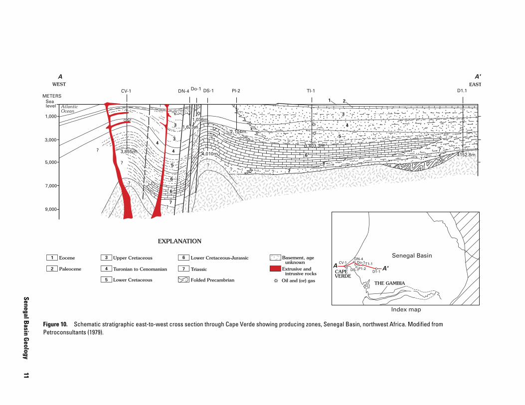
Figure 10. Schematic stratigraphic east-to-west cross section through Cape Verde showing producing zones, Senegal Basin, northwest Africa. Modified from Petroconsultants (1979).
12 Assessment of the Undiscovered Oil and Gas of Northwest Africa
Post-rift Section
Marine deposition began during the Early Jurassic in Morocco with transgressing seas reaching the southern end of the Senegal Basin by the Late Jurassic (Uchupi and others, 1976). The post-rift section in the Senegal Basin consists of Middle Jurassic to Holocene rocks. The section increases in thickness from east to west across the Senegal Basin. The basal unit of the post-rift sequence is a thick, carbonate-rock shelf of Middle to Late Jurassic to Neocomian age that is genetically related to the Tethys Sea. The carbonate-rock unit ranges in thickness from 2,300 m to 3,200 m in the Mauritania, Northern, and Casamance subbasins (figs. 7 and 8). During the Aptian and Albian this carbonate-rock unit continued to be deposited in the central offshore part of the basin, whereas in the northern part of the Mauritania subbasin and southernmost part of the Casamance subbasin it was replaced by deeper water sediments. The Cenomanian rocks of the post-rift section are represented by thick marine shales interbedded with marginal marine sand-stones, deposited after the opening of the Atlantic Ocean. Minor carbonate-rock banks and reefs are present. The Turonian marks the time of maximum Cretaceous transgression and is repre-sented by widespread black, and commonly bituminous, shale that is an important hydrocarbon source rock in the basin. The Turonian shales range in thickness from 50 to 150 m. The Senonian stage was a time of major marine regression that cul-minated with the deposition of widespread and thick sandstone units in the Maastrichtian. Tertiary sediments are unconformable with the Upper Cretaceous and consist primarily of marine shales and carbonates. The thickness of the post-rift section is about 12,000 m in the depocenter near the GBO–1 well (fig. 5) in the Guinea-Bissau part of the basin (Dumestre and Carvalho, 1985).
Two major stratigraphic domains delimited by the present shelf edge are recognized within the Senegal Basin. The shelf of northwest Africa is characterized by a 35- to 100-km-wide plain cut by sparse, shallow channels, especially north of Cape Verde (Egloff, 1972), while south of Cape Verde the shelf is more incised by canyons and affected by recent deltaic deposits. The shelf and western edge of the Jurassic to Lower Cretaceous carbonate-rock platform (fig. 3) roughly parallels the 200-m bathymetric contour.
East of the present shelf edge is a gently westward dipping Mesozoic and Cenozoic platform characterized by prograding deposits separated by regressive episodes and regional unconfor-mities. The section thins eastward so that the Paleozoic sequence is accessible to drilling over a large area. The Mesozoic section has not undergone any orogenic or compressional stress. Normal faults generally strike north-south and are typically downthrown to the west, reflecting the predominant tensional structural style during the Mesozoic and Cenozoic. Salt diapirs in the offshore Casamance and Mauritania subbasins have pierced the Mesozoic section and are prominent structural targets for exploration.
West of the shelf edge (greater than 200-m water depth) where the sedimentary thickness can exceed 12,000 m, the regional structural style is dominated by gravitational features
such as listric faulting and slumping, reflecting a slope environ-ment and the influence of the opening of the Atlantic. The cur-rent sedimentary depocenter is located west of the shelf edge in water depths of 1,000–2,000 m.
Petroleum Occurrence in the Senegal Basin
There are both offshore and onshore hydrocarbon occur-rences in several formations in the Senegal Basin. The best understood hydrocarbon occurrences in the Senegal Basin are in Cretaceous and Tertiary reservoirs in the Casamance, Northern, and Mauritania subbasins. The lower Paleozoic rocks contain oil-prone organic matter, and recent seismic data have delineated a pre-salt clastic section in the Lower Triassic. The Jurassic and Lower Cretaceous rocks have only been explored nearshore and contain continental-derived organic matter, which may be gas-prone.
Hydrocarbon production in the Senegal Basin has been limited to several small oil and gas fields (fig. 10) east of Cape Verde (Brown, 1981; Woodside, 1983). Discovered oil resources in the Senegal Basin are 10 MMBO, with gas resources of 49 BCFG (U.S. Geological Survey World Energy Assessment Team, 2000, disc 4, data file provvol.tab).
Hydrocarbon Source Rocks in the Senegal Basin
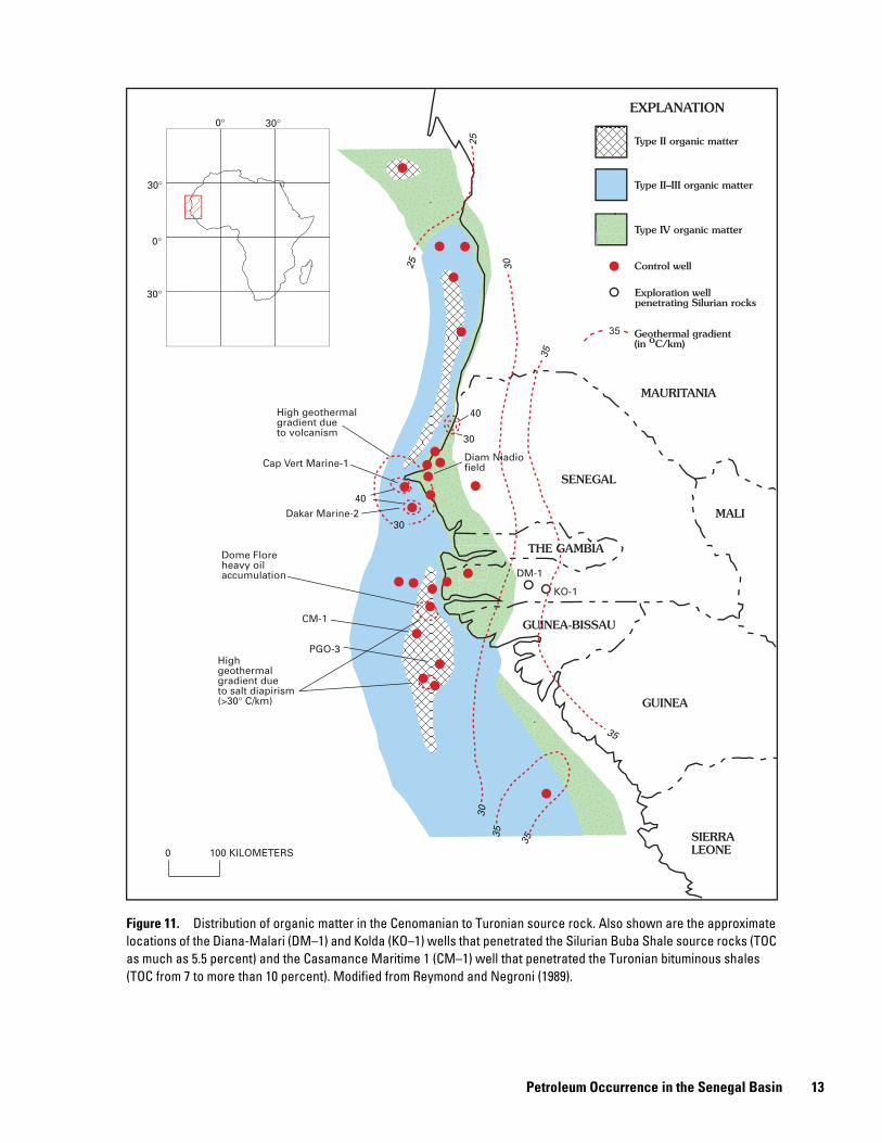
The most effective Cretaceous source rocks related to hydrocarbon discoveries and production in the Senegal Basin are the Cenomanian-Turonian marine shale units (figs. 7 and 8). Cenomanian to Turonian source rock units developed in two different subbasins (fig. 11). The first area is located north of Cape Verde and includes the Mauritania and Northern subbasins (fig. 3) where samples from wells located along the shelf bound-ary have exhibited good source rocks, up to 380 m thick, con-taining Type II and Type III organic matter (fig. 11) with hydro-carbon source potentials between 3 and 21 kg/ton (Reymond and Negroni, 1989). The second area is located south of Dakar in the Casamance subbasin. Reymond and Negroni (1989) state that the richest source rocks here contain Type II organic matter surrounded by a large area containing Type III organic matter (fig. 11). These source rocks display source potentials ranging between 5 and 75 kg/ton and range from 330 to 490 m thick. The Turonian interval contains bituminous shales that were probably deposited under anoxic conditions (Kuhnt and Wiedmann, 1995) with thickness up to 150 m (fig. 4). Samples analyzed from the Casamance Maritime 10 well (fig. 11) contain Type II kerogen with total organic carbon (TOC) values ranging from about 7 to more than 10 percent. Geochemical data obtained from Deep Sea Drilling Project well samples (DSDP 367 and 368, fig. 3) identified potential Neocomian to Cenomanian source rocks beyond the 2-second sediment isopach in the Senegal Basin (Tissot and others, 1980; Rullkötter and others, 1982). The source rocks contain mostly Type II kerogen with TOC values ranging from about 3 to more than 10 percent. Minor source
Petroleum Occurrence in the Senegal Basin 13
0°
0°
30°
30°
30°
Highgeothermalgradient dueto salt diapirism(>30° C/km)
High geothermalgradient dueto volcanism
MAURITANIA
SENEGAL
MALI
GUINEA-BISSAU
GUINEA
SIERRALEONE
THE GAMBIA
Type II organic matter
Type II–III organic matter
Type IV organic matter
Control well
35 Geothermal gradient(in oC/km)
35
35
35
30
30
30
25
30
40
0 100 KILOMETERS
25
40
Dome Floreheavy oilaccumulation
Diam Niadiofield
DM-1
KO-1
Exploration wellpenetrating Silurian rocks
CM-1
Cap Vert Marine-1
Dakar Marine-2
PGO-3
35
EXPLANATION
Figure 11. Distribution of organic matter in the Cenomanian to Turonian source rock. Also shown are the approximate locations of the Diana-Malari (DM–1) and Kolda (KO–1) wells that penetrated the Silurian Buba Shale source rocks (TOC as much as 5.5 percent) and the Casamance Maritime 1 (CM–1) well that penetrated the Turonian bituminous shales (TOC from 7 to more than 10 percent). Modified from Reymond and Negroni (1989).
14 Assessment of the Undiscovered Oil and Gas of Northwest Africa
rocks within the post-rift section have been identified (Dumestre and Carvalho, 1985; Reymond and Negroni, 1989) including the Senonian and Maastrichtian (2–5 kg/ton, Type II and III), the Paleogene (greater than 5 kg/ton, Type II with detrital Type IV), and the Miocene to Pliocene (2–5 kg/ton, Type II).
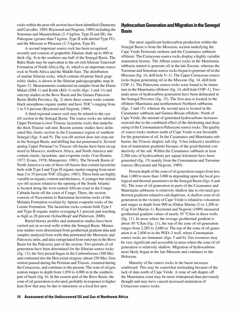
A second important source rock has been recognized recently and consists of graptolitic Silurian shale up to 400 m thick (fig. 4) in the southern one-half of the Senegal Basin. The Buba Shale may be equivalent to the oil-rich Silurian Tanezzuft Formation of North Africa (fig. 4), which is an important source rock in North Africa and the Middle East. The distribution of marine Silurian rocks, which contain oil-prone black grap-tolitic shales, is shown in the Silurian paleogeographic map in figure 12. Measurements conducted on samples from the Diana-Malari (DM–1) and Kolda (KO–1) wells (figs. 3 and 11) and outcrop studies in the Bove Basin and the Guinea Paleozoic Basin (Baffa Province, fig. 2) show these source rocks contain black amorphous organic matter and have TOC’s ranging from 1 to 5.5 percent (Reymond and Negroni, 1989).
A third regional source rock may be related to the syn- rift section in the Senegal Basin. The source rocks are inferred Upper Permian-Lower Triassic lacustrine rocks that underlie the thick Triassic salt unit. Recent seismic studies have delin-eated this clastic section in the Casamance region of southern Senegal (figs. 6 and 9). The syn-rift section does not crop out in the Senegal Basin, and drilling has not penetrated it. Several analog Upper Permian? to Triassic rift basins have been recog-nized in Morocco, northwest Africa, and North America and contain clastic, lacustrine, and evaporite rocks (Van Houten, 1977; Evans, 1978; Manspeizer, 1981). The Newark Basin of North America is one of these rift basins that contain lacustrine beds with Type I and Type II organic matter ranging from more than 2 to 35 percent TOC (Ziegler, 1983). These beds are highly variable in organic content and thickness. A younger but similar syn-rift section related to the opening of the South Atlantic is located along the west-central African coast in the Congo-Cabinda basin off the coast of Congo. There, the section consists of Neocomian to Barremian lacustrine rocks of the Melania Formation overlain by Aptian evaporite rocks of the Loeme Formation. The lacustrine rocks contain both Type I and Type II organic matter averaging 6.1 percent and reaching as high as 20 percent (Schoellkopf and Patterson, 2000).
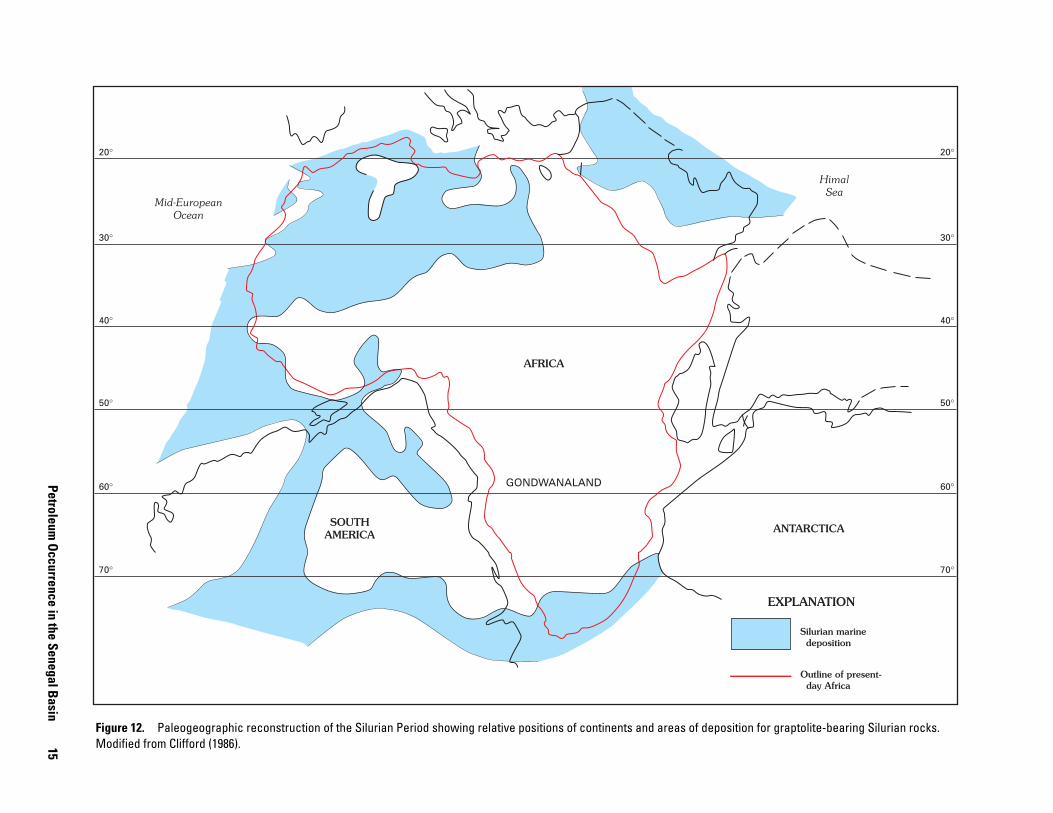
Burial history profiles and maturation studies have been carried out on several wells within the Senegal Basin. Matura-tion studies were determined from geothermal gradient data and samples analyzed from wells that penetrated the Mesozoic and Paleozoic units, and data extrapolated from outcrops in the Bove Basin for the Paleozoic part of the section. Two periods of oil generation have been determined for the Silurian source rocks (fig. 13); the first period began in the Carboniferous (300 Ma) and continued into the Hercynian orogeny (about 250 Ma). Gen-eration paused during the Permian and Triassic, resumed during the Cretaceous, and continues to the present. The zone of oil gen-eration ranges in depth from 1,850 to 4,000 m in the southern part of basin (fig. 6). In the eastern part of the Bove Basin, the zone of oil generation is elevated, probably in response to higher heat flow that may be due to intrusions or a local hot spot.
Hydrocarbon Generation and Migration in the Senegal Basin
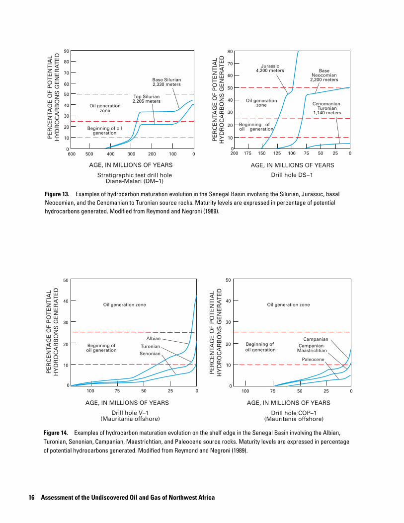
The most significant hydrocarbon production within the Senegal Basin is from the Mesozoic section underlying the Cape Verde Peninsula onshore and the Casamance subbasin offshore. The Cretaceous source rocks display a highly variable maturation history. The Albian source rocks in the Mauritania subbasin started to generate oil in the late Eocene, whereas the Turonian and Senonian source rocks began to generate oil in the Miocene (fig. 14, drill hole V–1). The Upper Cretaceous source rocks began generating oil in the Miocene (fig. 14, drill hole COP–1). The Paleocene source rocks were found to be imma-ture in the Mauritania offshore (fig. 14, drill hole COP–1). Two main areas of hydrocarbon generation have been delineated in the Senegal Province (fig. 15). The first area is located in the offshore Mauritania and northernmost Northern subbasins (figs. 3 and 15), whereas the second area is located in the Casamance subbasin and Guinea-Bissau offshore. North of Cape Verde, the amount of generated hydrocarbons increases seaward due to the combined effect of the thickening and deep-ening of the Cenomanian to Paleocene source rocks. The quality of source rocks onshore north of Cape Verde is not favorable for the generation of oil. In the Casamance and Mauritania sub-basins, the Triassic diapiric salt (fig. 3) has induced a modifica-tion of maturation gradients because of the good thermal con-ductivity of the salt. Within the Casamance subbasin at least 2,500 tons of hydrocarbons per square kilometer have been generated (fig. 15) mainly from the Cenomanian and Turonian sources (Reymond and Negroni, 1989).
Present depth of the zone of oil generation ranges from less than 1,000 to more than 3,000 m depending upon the local geo-logical and thermal parameters in the Senegal Basin (figs. 6 and 16). The zone of oil generation in parts of the Casamance and Mauritania subbasins is relatively shallow due to elevated geo-thermal gradients related to salt diapirism. A shallow zone of oil generation in the vicinity of Cape Verde is related to volcanism and ranges in depth from 900 m (Dakar Marine-2) to 1,200 m (Cap Vert Marine-1). Reymond and Negroni (1989) measured geothermal gradient values of nearly 45 °C/km in these wells (fig. 11). In areas where the average geothermal gradient is about 30 °C/km (fig. 11), the top of the zone of oil generation ranges from 2,285 to 2,680 m. The top of the zone of oil gener-ation is at 2,800 m in the PGO–3 well, where Cenomanian source rocks are immature (figs. 5 and 6). Gas resources may be very significant and accessible in areas where the zone of oil generation is relatively shallow. Migration of hydrocarbons most likely began in the late Miocene and continues to the Holocene.
Maturity of the source rocks in the basin increases southward. This may be somewhat misleading because of the lack of data north of Cape Verde. A zone of salt diapirs off the Mauritania coast may be more widespread than previously thought and may have caused increased maturation of Cretaceous source rocks.
Petroleum O
ccurrence in the Senegal Basin
15
Silurian marine deposition
AFRICA
SOUTHAMERICA
GONDWANALAND
ANTARCTICA
Mid-EuropeanOcean
HimalSea
Outline of present- day Africa
20°
30°
40°
50°
60°
70°
20°
30°
40°
50°
60°
70°
EXPLANATION
Figure 12. Paleogeographic reconstruction of the Silurian Period showing relative positions of continents and areas of deposition for graptolite-bearing Silurian rocks. Modified from Clifford (1986).
16 Assessment of the Undiscovered Oil and Gas of Northwest Africa
PE
RC
EN
TAG
E O
F P
OT
EN
TIA
LH
YD
RO
CA
RB
ON
S G
EN
ER
AT
ED
PE
RC
EN
TAG
E O
F P
OT
EN
TIA
LH
YD
RO
CA
RB
ON
S G
EN
ER
AT
ED
AGE, IN MILLIONS OF YEARS AGE, IN MILLIONS OF YEARS
500600 400 300 200 100 0
Top Silurian2,205 meters
Base Silurian2,330 meters
Oil generationzone
Beginning of oilgeneration
Stratigraphic test drill holeDiana-Malari (DM–1)
175200 150 125 100 75 50 25 0
Beginning of oil generation
Oil generationzone
Jurassic4,200 meters Base
Neocomian2,200 meters
Cenomanian-Turonian
1,140 meters
Drill hole DS–1
90
80
70
60
50
40
30
20
10
0
80
70
60
50
40
30
20
10
0
PE
RC
EN
TAG
E O
F P
OT
EN
TIA
LH
YD
RO
CA
RB
ON
S G
EN
ER
AT
ED
PE
RC
EN
TAG
E O
F P
OT
EN
TIA
LH
YD
RO
CA
RB
ON
S G
EN
ER
AT
ED
AGE, IN MILLIONS OF YEARS AGE, IN MILLIONS OF YEARS
100 75 50 25 0
Oil generation zone Oil generation zone
Beginning ofoil generation
Albian
Turonian
Senonian
Drill hole V–1(Mauritania offshore)
Drill hole COP–1(Mauritania offshore)
50
40
30
20
10
0100 75 50 25 0
Beginning of oil generation
50
40
30
20
10
0
CampanianCampanian-
Maastrichtian
Paleocene
Figure 13. Examples of hydrocarbon maturation evolution in the Senegal Basin involving the Silurian, Jurassic, basal Neocomian, and the Cenomanian to Turonian source rocks. Maturity levels are expressed in percentage of potential hydrocarbons generated. Modified from Reymond and Negroni (1989).
Figure 14. Examples of hydrocarbon maturation evolution on the shelf edge in the Senegal Basin involving the Albian, Turonian, Senonian, Campanian, Maastrichtian, and Paleocene source rocks. Maturity levels are expressed in percentage of potential hydrocarbons generated. Modified from Reymond and Negroni (1989).
Petroleum Occurrence in the Senegal Basin 17
SIERRALEONE
GUINEA
MALI
GUINEA-BISSAU
SENEGAL
SENEGAL
MAURITANIA
THE GAMBIA
0 100 KILOMETERS
AtlanticOcean
1,000 Isogeneration contours in 1,000 tons of hydrocarbon per square kilometer
Exploration well
Diam Niadiofield
DomeFloreheavy oilaccumulation
25
100
25
2550
0
500
?
?
??
?
??
?
?2,
500
1,50
0
1,50
0
1,00
01,
000
100
500
0°
0°
30°
30°
30°
CAPE VERDE
V-1
COP-1
CM-10
Casamancesubbasin—area 2
Mauritaniasubbasin—area 1
Nor
ther
n su
bbas
in
Subbasin boundary— approximately located
EXPLANATION
Figure 15. Isogeneration map of the Cenomanian to Paleocene source rocks in the Senegal Province. Two main source/generation areas, the Casamance subbasin and a large offshore area in the Mauritania subbasin, were delineat-ed using Rock-Eval; maturity levels expressed in percentage of potential hydrocarbons generated (fig. 14) and net thick-ness of the source rocks. Modified from Reymond and Negroni (1989).
18 Assessment of the Undiscovered Oil and Gas of Northwest Africa
EXPLANATION
EXPLANATION
Offshore
Offshore
Offshore
Onshore
Onshore
Onshore
Mature zone
+
KIL
OM
ET
ER
SK
ILO
ME
TE
RS
KIL
OM
ET
ER
S
1
2
3
4
5
6
7
1
2
3
4
5
6
7
1
2
3
4
5
6
7
8
+
+
+ ++
+ +
++ +
Paleocene
Jurassic
Upper Cretaceous
Lower Cretaceous
Mature zone
Northern part
Cenomanian-Turonian
Oligocene
Eocene
+ + +
+ + + + + +
+ + +
lower Senonian
LowerCretaceous
Jurassic
Central part
Oligocene-Miocene
lower Eocene
Maastrichtian
UpperCretaceous
Sealevel
upper Senonian
Paleocene
Permian-Triassic
Triassic
Triassic ?
Turonian
++++++
+++++++++
++
++
++
+++
+
++
++
++
++
+
++++
+++
+ +
Southern partSealevel
Sealevel
lower-upper MiocenePaleocene to lower Miocene
Senonian
Aptian-AlbianNeocomian
DevonianCarboniferous-Permian
Silurian
OrdovicianCambro-Ordovician
Basement
Basement
BasementMature zone
Miocene-Pliocene
EXPLANATION
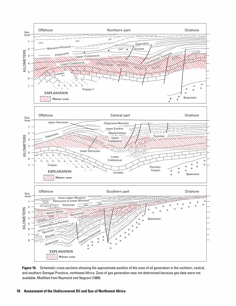
Figure 16. Schematic cross sections showing the approximate position of the zone of oil generation in the northern, central, and southern Senegal Province, northwest Africa. Zone of gas generation was not determined because gas data were not available. Modified from Reymond and Negroni (1989).
Total Petroleum Systems of the Senegal Province 19
Hydrocarbon Reservoirs, Traps, and Seals in the Senegal Basin
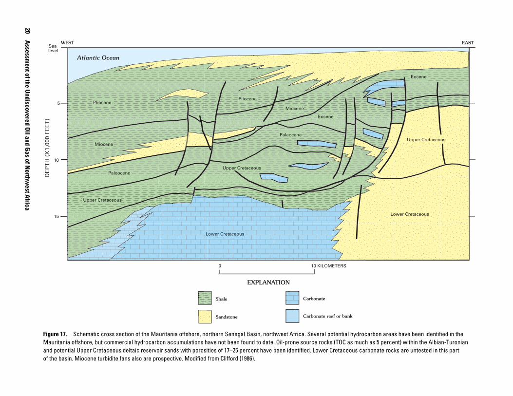
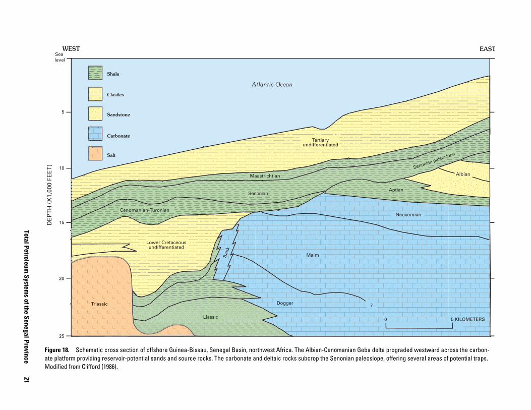
The Mesozoic-Cenozoic section of the Senegal Basin can exceed 10,000 m in thickness and contains several primary reservoirs and seals: (1) Jurassic-Lower Cretaceous carbonate section sealed by Cenomanian or other Lower Cretaceous shales; (2) Upper Cretaceous sandstone units and overlying shale units; and (3) lower Tertiary clastic and carbonate-rock units and overlying and intercalated shale units (figs. 6, 9, and 10). Cretaceous deltaic sandstone (Clifford, 1986) with porosi-ties ranging from 17 to 25 percent are present in the Mauritania offshore (fig. 17). The Jurassic-Lower Cretaceous carbonate-rock platform has never been fully penetrated by drilling but does show good porosities ranging from 10 to 23 percent (figs. 17 and 18). Reef prospects on the shelf edge remain to be explored. Upper Cretaceous sandstone sequences in the east-ern part of the basin become interbedded with shale to the west-ern offshore part of the basin. Maastrichtian sandstones up to 30 m thick occur at Dome Flore, with porosities ranging from 20 to 30 percent, and contain light oil (33.6° API). In the Dome Flore area, an excellent Oligocene carbonate-rock reservoir exists and contains up to 1 billion barrels of heavy oil (10° API, 1.6 percent sulfur) in place. About 40 km east of Dakar, several shallow oil and gas discoveries were made in the 1950’s. Fol-lowing a geologic reinterpretation of the area in 1984 (Dumestre, 1985), these wells and two new wells were found to be produc-tive, with rates up to 300 barrels of oil per day (BO/D) and 2.4 million cubic feet of gas per day (MMCFG/D). Currently, only a small amount of gas is being produced from the Diam Niadio field (fig. 11).
The Mesozoic-Cenozoic section in the Senegal Basin con-tains diverse oil and gas trapping configurations. These include salt-related structures, structures related to volcanic intrusion, growth-fault-related traps, slope truncation traps along the present shelf edge, sandstone pinch-outs along the eastern mar-gin of the Senegal Basin, Jurassic-Lower Cretaceous carbonate bank deposits, and possible turbidite-related stratigraphic traps. Seals consist of Mesozoic and Cenozoic marine shales and faults.
Sandstone reservoirs associated with syn-rift rocks might be present and interbedded with the inferred Permian-Triassic source rocks underlying the Triassic salt (fig. 9). The thick Triassic salt is the major seal in the syn-rift section in the Senegal Basin.
Potential sandstone reservoirs are abundant in lower Paleozoic rocks based on measured sections in the Bove Basin and analyzed samples from the DM–1 and KO–1 stratigraphic test wells (fig. 3). The Ordovician sandstones are intensely frac-tured and could constitute good secondary reservoirs, whereas the Devonian fine- to coarse-grained sandstone beds have porosities ranging from 15 to 20 percent. In the onshore portion of the Paleozoic basin, regional seismic data have shown that the Paleozoic section has been faulted and could form traps in conjunction with the Paleozoic unconformity (fig. 6). Interpre-tation of seismic data shows that the Paleozoic unconformity is
at a depth of about 10,000 m at the PGO–3 (fig. 6) exploration hole in the Guinea-Bissau offshore. The Paleozoic reservoirs were not assessed in this study.
Total Petroleum Systems of the Senegal Province
At least three total petroleum systems (TPS) may be present in the Senegal Province: (1) the hypothetical Lower Paleozoic Total Petroleum System consisting of Silurian source rocks and Ordovician to Devonian and Triassic reservoir rocks; (2) the hypothetical Sub-salt Total Petroleum System consisting of Triassic (?) lacustrine source rocks and clastic reservoirs capped by Triassic salt; and (3) the Cretaceous-Tertiary Composite Total Petroleum System consisting of Cenomanian-Turonian source rocks and Cretaceous and Tertiary reservoirs. Only limited drilling and seismic information is available for the Lower Paleozoic TSP, whereas there is no drilling and only limited seismic information on the Sub-salt TSP. Only the Cretaceous-Tertiary Composite Total Petroleum System was considered for this assessment because current production and exploration data were almost entirely limited to the Cretaceous. We defined one assessment unit within the TSP—the Coastal Plain and Offshore Assessment Unit.
Lower Paleozoic and Sub-salt Total Petroleum Systems
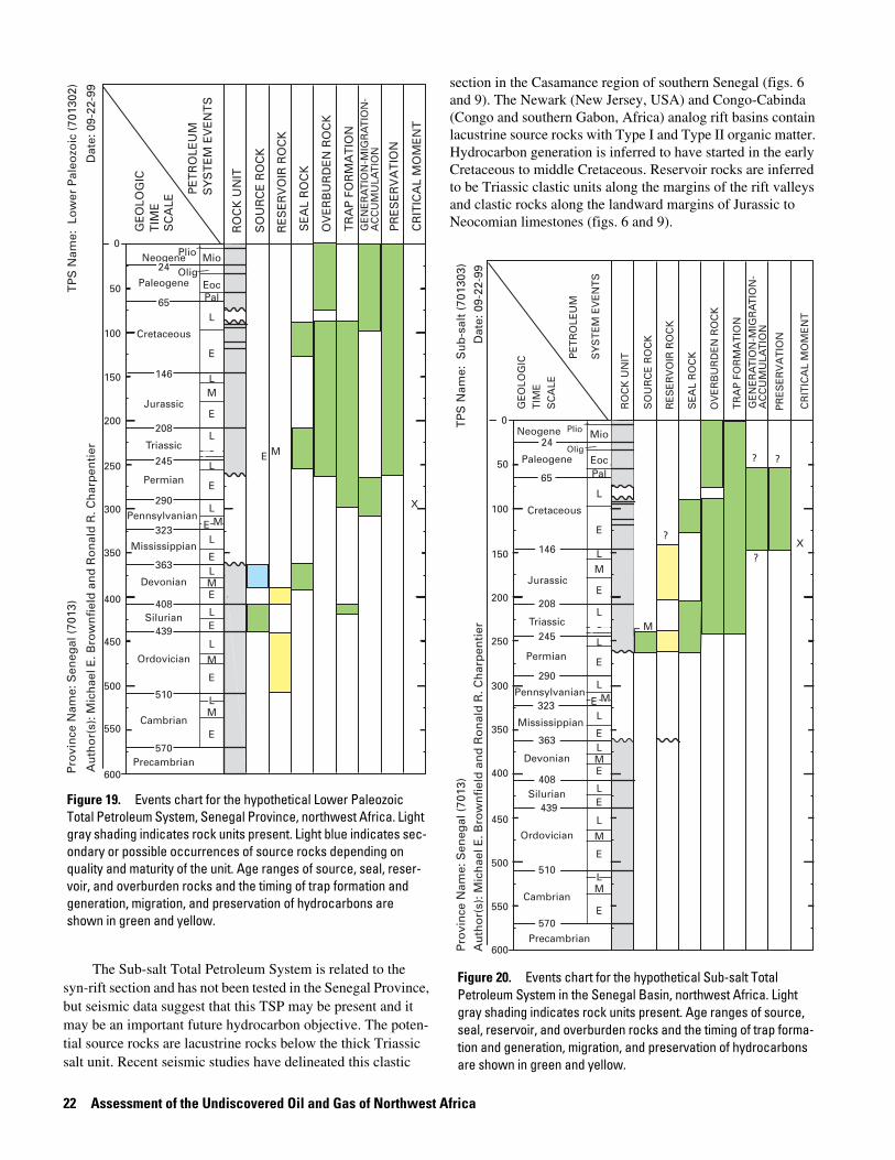
Events charts (figs. 19 and 20) for the Lower Paleozoic and Sub-salt Total Petroleum Systems summarize the age of the source, seal, and reservoir rocks and the timing of trap development and generation and migration of hydrocarbons.
The likely source rocks for the Lower Paleozoic Total Petroleum System are oil-prone graptolite-bearing Silurian shale that may be as much as 400 m thick (fig. 4) in the southern one-half of the Senegal Province. Measurements carried out in the Diana-Malari (DM–1) and Kolda (KO–1) wells and outcrop studies in the Bove Basin and the Guinea Paleozoic Basin show these source rocks to contain moderate organic matter and have TOC contents ranging from 1 to 5.5 percent (Reymond and Negroni, 1989). Two periods of oil generation have been deter-mined for the Silurian source rocks and the first period began in the Carboniferous (300 Ma) and continued into the Hercynian orogeny (fig. 13). Generation paused during the Permian and Triassic, resumed during the Cretaceous, and continues to the present. Sandstone reservoirs have been shown to be abundant in the lower Paleozoic section based on measured sections in the Bove Basin and analyzed samples from stratigraphic test wells (fig. 3). The Ordovician sandstones could be good secondary reservoirs, whereas the Devonian fine- to coarse-grained sand-stone beds have porosities ranging from 15 to 20 percent and could comprise a third type of potential reservoirs.
20 A
ssessment of the U
ndiscovered Oil and G
as of Northw
est Africa
PliocenePliocene
Miocene
Miocene
Eocene
Eocene
Paleocene
Paleocene
Lower Cretaceous
Upper Cretaceous
Upper Cretaceous
WEST EAST
Upper Cretaceous
Atlantic Ocean
Lower Cretaceous
5
10
15
DE
PT
H (
X1,
000
FEE
T)
0 10 KILOMETERS
Shale
Sandstone
Carbonate
Carbonate reef or bank
EXPLANATION
Sea level
Figure 17. Schematic cross section of the Mauritania offshore, northern Senegal Basin, northwest Africa. Several potential hydrocarbon areas have been identified in the Mauritania offshore, but commercial hydrocarbon accumulations have not been found to date. Oil-prone source rocks (TOC as much as 5 percent) within the Albian-Turonian and potential Upper Cretaceous deltaic reservoir sands with porosities of 17–25 percent have been identified. Lower Cretaceous carbonate rocks are untested in this part of the basin. Miocene turbidite fans also are prospective. Modified from Clifford (1986).
Total Petroleum System
s of the Senegal Province
21
Shale
Clastics
Sandstone
Carbonate
Salt
Liassic
?Dogger
Malm
Neocomian
Lower Cretaceousundifferentiated
Aptian
AlbianSenonian paleoslope
Cenomanian-Turonian
Senonian
Tertiaryundifferentiated
Maastrichtian
Triassic
25
20
15
10
5
WEST EASTD
EP
TH
(X
1,00
0 FE
ET
)
Ban
k
Atlantic Ocean
Sea level
5 KILOMETERS0
Figure 18. Schematic cross section of offshore Guinea-Bissau, Senegal Basin, northwest Africa. The Albian-Cenomanian Geba delta prograded westward across the carbon-ate platform providing reservoir-potential sands and source rocks. The carbonate and deltaic rocks subcrop the Senonian paleoslope, offering several areas of potential traps. Modified from Clifford (1986).
22 Assessment of the Undiscovered Oil and Gas of Northwest Africa
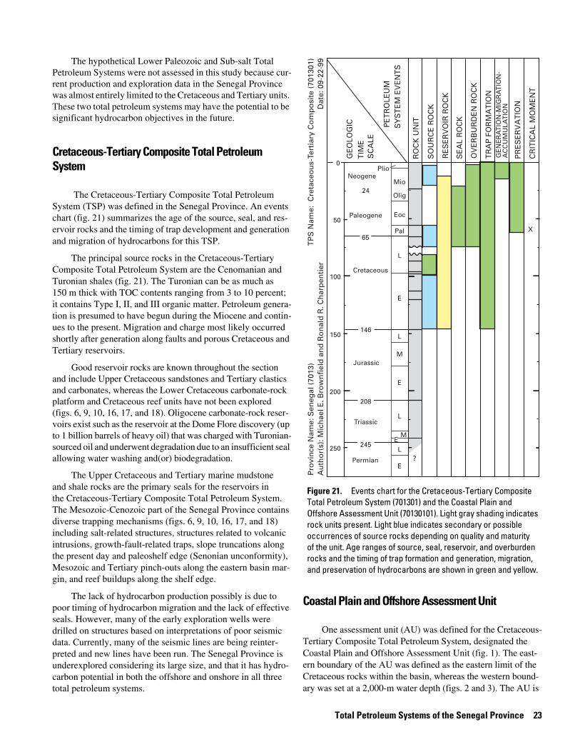
The Sub-salt Total Petroleum System is related to the syn-rift section and has not been tested in the Senegal Province, but seismic data suggest that this TSP may be present and it may be an important future hydrocarbon objective. The poten-tial source rocks are lacustrine rocks below the thick Triassic salt unit. Recent seismic studies have delineated this clastic
section in the Casamance region of southern Senegal (figs. 6 and 9). The Newark (New Jersey, USA) and Congo-Cabinda (Congo and southern Gabon, Africa) analog rift basins contain lacustrine source rocks with Type I and Type II organic matter. Hydrocarbon generation is inferred to have started in the early Cretaceous to middle Cretaceous. Reservoir rocks are inferred to be Triassic clastic units along the margins of the rift valleys and clastic rocks along the landward margins of Jurassic to Neocomian limestones (figs. 6 and 9).
0
100
200
300
400
500
600
50
150
250
350
450
550
Paleogene
Cretaceous
Jurassic
Triassic
Permian
Precambrian
Cambrian
Ordovician
Silurian
Devonian
E
ML
E
E
E
E
E
E
E
E
E
M
M
M
M
M
L
L
L
L
L
L
L
L
L
Mississippian
Pennsylvanian
Neogene
PalEoc
OligMioPlio
PR
ES
ER
VA
TIO
N
CR
ITIC
AL
MO
ME
NT
TR
AP
FO
RM
AT
ION
OV
ER
BU
RD
EN
RO
CK
RE
SE
RV
OIR
RO
CK
SE
AL
RO
CK
SO
UR
CE
RO
CK
RO
CK
UN
IT
PE
TR
OLE
UM
SY
ST
EM
EV
EN
TS
GE
OLO
GIC
T
IME
SC
ALE
TP
S N
ame:
Lo
wer
Pal
eozo
ic (
7013
02)
Pro
vin
ce N
ame:
Sen
egal
(70
13)
Au
tho
r(s)
: Mic
hae
l E. B
row
nfi
eld
an
d R
on
ald
R. C
har
pen
tier
Dat
e: 0
9-22
-99
X
24
65
146
208
245
363
570
510
439
408
290
323
GE
NE
RA
TIO
N-M
IGR
AT
ION
-A
CC
UM
ULA
TIO
N
Figure 19. Events chart for the hypothetical Lower Paleozoic Total Petroleum System, Senegal Province, northwest Africa. Light gray shading indicates rock units present. Light blue indicates sec-ondary or possible occurrences of source rocks depending on quality and maturity of the unit. Age ranges of source, seal, reser-voir, and overburden rocks and the timing of trap formation and generation, migration, and preservation of hydrocarbons are shown in green and yellow.
0
100
200
300
400
500
600
50
150
250
350
450
550
Paleogene
Cretaceous
Jurassic
Triassic
Permian
65
146
208
245
363
570
510
439
408
Precambrian
Cambrian
Ordovician
Silurian
Devonian
290
323
E
ML
E
E
E
E
E
E
E
E
E
M
M
M
M
M
L
L
L
L
L
L
L
L
L
Mississippian
Pennsylvanian
Neogene24
PalEoc
Olig
MioPlio
CR
ITIC
AL
MO
ME
NT
TR
AP
FO
RM
AT
ION
OV
ER
BU
RD
EN
RO
CK
RE
SE
RV
OIR
RO
CK
SE
AL
RO
CK
SO
UR
CE
RO
CK
RO
CK
UN
ITPE
TR
OLE
UM
SY
ST
EM
EV
EN
TS
GE
OLO
GIC
T
IME
SC
ALE
TP
S N
ame:
Su
b-s
alt
(701
303)
Pro
vin
ce N
ame:
Sen
egal
(70
13)
Au
tho
r(s)
: Mic
hae
l E. B
row
nfi
eld
an
d R
on
ald
R. C
har
pen
tier
Dat
e: 0
9-22
-99
X?
?
? ?
PR
ES
ER
VA
TIO
N
GE
NE
RA
TIO
N-M
IGR
AT
ION
-A
CC
UM
ULA
TIO
N
Figure 20. Events chart for the hypothetical Sub-salt Total Petroleum System in the Senegal Basin, northwest Africa. Light gray shading indicates rock units present. Age ranges of source, seal, reservoir, and overburden rocks and the timing of trap forma-tion and generation, migration, and preservation of hydrocarbons are shown in green and yellow.
Total Petroleum Systems of the Senegal Province 23
The hypothetical Lower Paleozoic and Sub-salt Total Petroleum Systems were not assessed in this study because cur-rent production and exploration data in the Senegal Province was almost entirely limited to the Cretaceous and Tertiary units. These two total petroleum systems may have the potential to be significant hydrocarbon objectives in the future.
Cretaceous-Tertiary Composite Total Petroleum System
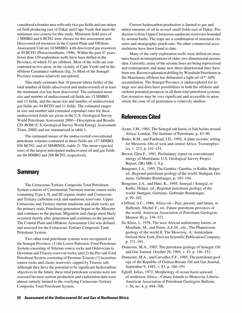
The Cretaceous-Tertiary Composite Total Petroleum System (TSP) was defined in the Senegal Province. An events chart (fig. 21) summarizes the age of the source, seal, and res-ervoir rocks and the timing of trap development and generation and migration of hydrocarbons for this TSP.
The principal source rocks in the Cretaceous-Tertiary Composite Total Petroleum System are the Cenomanian and Turonian shales (fig. 21). The Turonian can be as much as 150 m thick with TOC contents ranging from 3 to 10 percent; it contains Type I, II, and III organic matter. Petroleum genera-tion is presumed to have begun during the Miocene and contin-ues to the present. Migration and charge most likely occurred shortly after generation along faults and porous Cretaceous and Tertiary reservoirs.
Good reservoir rocks are known throughout the section and include Upper Cretaceous sandstones and Tertiary clastics and carbonates, whereas the Lower Cretaceous carbonate-rock platform and Cretaceous reef units have not been explored (figs. 6, 9, 10, 16, 17, and 18). Oligocene carbonate-rock reser-voirs exist such as the reservoir at the Dome Flore discovery (up to 1 billion barrels of heavy oil) that was charged with Turonian-sourced oil and underwent degradation due to an insufficient seal allowing water washing and(or) biodegradation.
The Upper Cretaceous and Tertiary marine mudstone and shale rocks are the primary seals for the reservoirs in the Cretaceous-Tertiary Composite Total Petroleum System. The Mesozoic-Cenozoic part of the Senegal Province contains diverse trapping mechanisms (figs. 6, 9, 10, 16, 17, and 18) including salt-related structures, structures related to volcanic intrusions, growth-fault-related traps, slope truncations along the present day and paleoshelf edge (Senonian unconformity), Mesozoic and Tertiary pinch-outs along the eastern basin mar-gin, and reef buildups along the shelf edge.
The lack of hydrocarbon production possibly is due to poor timing of hydrocarbon migration and the lack of effective seals. However, many of the early exploration wells were drilled on structures based on interpretations of poor seismic data. Currently, many of the seismic lines are being reinter-preted and new lines have been run. The Senegal Province is underexplored considering its large size, and that it has hydro-carbon potential in both the offshore and onshore in all three total petroleum systems.
Coastal Plain and Offshore Assessment Unit
One assessment unit (AU) was defined for the Cretaceous-Tertiary Composite Total Petroleum System, designated the Coastal Plain and Offshore Assessment Unit (fig. 1). The east- ern boundary of the AU was defined as the eastern limit of the Cretaceous rocks within the basin, whereas the western bound-ary was set at a 2,000-m water depth (figs. 2 and 3). The AU is
X
TP
S N
ame:
Cre
tace
ou
s-Te
rtia
ry C
om
po
site
(70
1301
)P
rovi
nce
Nam
e: S
eneg
al (
7013
)A
uth
or(
s): M
ich
ael E
. Bro
wn
fiel
d a
nd
Ro
nal
d R
. Ch
arp
enti
erD
ate:
09-
22-9
9
PR
ES
ER
VA
TIO
N
CR
ITIC
AL
MO
ME
NT
TR
AP
FO
RM
AT
ION
OV
ER
BU
RD
EN
RO
CK
RE
SE
RV
OIR
RO
CK
SE
AL
RO
CK
SO
UR
CE
RO
CK
RO
CK
UN
ITPE
TR
OLE
UM
SY
ST
EM
EV
EN
TS
GE
OLO
GIC
T
IME
SC
ALE
0
100
200
50
150
250
Paleogene
Cretaceous
Jurassic
Triassic
Permian
65
146
208
245
E
E
E
M
M
L
L
L
L
Neogene
24
Pal
Eoc
Olig
Mio
Plio
?
E
GE
NE
RA
TIO
N-M
IGR
AT
ION
-A
CC
UM
ULA
TIO
N
Figure 21. Events chart for the Cretaceous-Tertiary Composite Total Petroleum System (701301) and the Coastal Plain and Offshore Assessment Unit (70130101). Light gray shading indicates rock units present. Light blue indicates secondary or possible occurrences of source rocks depending on quality and maturity of the unit. Age ranges of source, seal, reservoir, and overburden rocks and the timing of trap formation and generation, migration, and preservation of hydrocarbons are shown in green and yellow.
24 Assessment of the Undiscovered Oil and Gas of Northwest Africa
considered a frontier area with only two gas fields and one minor oil field producing east of Dakar and Cape Verde that meet the minimum size criteria for this study. Minimum field sizes of 1 MMBO and 6 BCFG were chosen for this assessment unit. Discovered oil resources in the Coastal Plain and Offshore Assessment Unit are 10 MMBO, with discovered gas resources at 49 BCFG (Petroconsultants, 1996). Within the past 47 years, fewer than 150 exploration wells have been drilled in the Province, of which 52 are offshore. Most of the wells are con-centrated in two areas, in the vicinity of Cape Verde and in the offshore Casamance subbasin (fig. 3). Most of the Senegal Province remains relatively unexplored.
This study estimates that 10 percent (three fields) of the total number of fields (discovered and undiscovered) of at least the minimum size has been discovered. The estimated mean size and number of undiscovered oil fields are 12 MMBO and 13 fields, and the mean size and number of undiscovered gas fields are 44 BCFG and 11 fields. The estimated ranges in size and number and estimated coproduct ratio for these undiscovered fields are given in the U.S. Geological Survey World Petroleum Assessment 2000—Description and Results CD–ROM (U.S. Geological Survey World Energy Assessment Team, 2000) and are summarized in table 1.
The estimated means of the undiscovered conventional petroleum volumes contained in these fields are 157 MMBO, 856 BCFG, and 43 MMBNGL (table 2). The mean expected sizes of the largest anticipated undiscovered oil and gas fields are 66 MMBO and 208 BCFG, respectively.
Summary
The Cretaceous-Tertiary Composite Total Petroleum System consists of Cenomanian-Turonian marine source rocks containing Type I, II, and III organic matter and Cretaceous and Tertiary carbonate-rock and sandstone reservoirs. Upper Cretaceous and Tertiary marine mudstone and shale rocks are the primary seals. Petroleum generation began in the Miocene and continues to the present. Migration and charge most likely occurred shortly after generation and continues to the present. The Coastal Plain and Offshore Assessment Unit was defined and assessed for the Cretaceous-Tertiary Composite Total Petroleum System.
Two other total petroleum systems were recognized in the Senegal Province: (1) the Lower Paleozoic Total Petroleum System consisting of Silurian source rocks and Ordovician to Devonian and Triassic reservoir rocks; and (2) the Pre-salt Total Petroleum System consisting of Permian-Triassic (?) lacustrine source rocks and clastic reservoirs capped by Triassic salt. Although they have the potential to be significant hydrocarbon objectives in the future, these total petroleum systems were not assessed because current production and exploration data were almost entirely limited to the overlying Cretaceous-Tertiary Composite Total Petroleum System.
Current hydrocarbon production is limited to gas and minor amounts of oil in several small fields east of Dakar. Pro-duction is from Upper Cretaceous sandstone reservoirs bounded by normal faults. The traps are a combination of structural clo-sures and stratigraphic pinch-outs. No other commercial accu-mulations have been found to date.
Many of the early exploration wells were drilled on struc-tures based on interpretations of older, two-dimensional seismic data. Currently, many of the seismic lines are being reprocessed and reinterpreted, and many new three-dimensional lines have been run. Recent exploration drilling by Woodside Petroleum in the Mauritania offshore has delineated a light oil (47° API) accumulation. The Senegal Province is underexplored for its large size and does have possibilities in both the offshore and onshore potential prospects in all three total petroleum systems. Gas resources may be very significant and accessible in areas where the zone of oil generation is relatively shallow.
References Cited
Ayme, J.M., 1965, The Senegal salt basin, in Salt basins around Africa: London, The Institute of Petroleum, p. 83–90.
Binks, R.M., and Fairhead, J.D., 1992, A plate tectonic setting for Mesozoic rifts of west and central Africa: Tectonophys-ics, v. 213, p. 141–151.
Brown, Glen F., 1981, Preliminary report on conventional energy of Mauritania: U.S. Geological Survey Project Report, (IR) MR–1, 8 p.
Bungener, J.A., 1995, The Gambia / Gambia, in Kulke, Holger, ed., Regional petroleum geology of the world: Stuttgart, Ger-many, Gebruder Borntraeger, p. 103–104.
Bungener, J.A., and Hinz, K., 1995, Senegal / Senegal, in Kulke, Holger, ed., Regional petroleum geology of the world: Stuttgart, Germany, Gebruder Borntraeger, p. 99–102.
Clifford, A.C., 1986, Africa oil—Past, present, and future, in Halbouty, Michel T., ed., Future petroleum provinces of the world: American Association of Petroleum Geologists Memoir 40, p. 339–372.
De Klasz, I., 1978, The west African sedimentary basins, in Moullade, M., and Nairn, A.E.M., eds., The Phanerozoic geology of the world II, The Mesozoic, A: Amsterdam-Oxford-New York, Elsevier Scientific Publication Company, p. 371–391.
Dumestre, M.A., 1985, The petroleum geology of Senegal: Oil and Gas Journal, October 28, 1985, v. 83, p. 146–152.
Dumestre, M.A., and Carvalho, F.F., 1985, The petroleum geol-ogy of the Republic of Guinea-Bissau: Oil and Gas Journal, September 9, 1985, v. 83, p. 180–191.
Egloff, Julius, 1972, Morphology of ocean basin seaward of northwest Africa—Canary Islands to Monrovia, Liberia: American Association of Petroleum Geologists Bulletin, v. 56, no. 4, p. 694–706.
References Cited 25
Environmental Systems Research Institute, 1992, ArcWorld 1:3M digital database: Environmental Systems Research Institute, Inc. (ESRI), available from ESRI, Redlands, Calif., scale: 1:3,000,000.
Evans, R., 1978, Origin and significance of evaporites in basin around Atlantic margin: American Association of Petroleum Geologists Bulletin, v. 62, no. 2, p. 223–234.
Guiraud, Rene, and Maurin, Jean-Christophe, 1992, Early Cre-taceous rifts of western and central Africa—An overview: Tectonophysics, v. 213, p. 153–168.
Hinz, K., and Martin, G., 1995, Mauritania / Mauritanien, in Kulke, Holger, ed., Regional petroleum geology of the world: Stuttgart, Germany, Gebruder Borntraeger, p. 93–98.
Klett, T.R., Ahlbrandt, T.S., Schmoker, J.W., and Dolton, G.L., 1997, Ranking of the world’s oil and gas provinces by known petroleum volumes: U.S. Geological Survey Open-File Report 97–463, CD–ROM.
Klett, T.R., Schmoker, J.W., and Ahlbrandt, T.S., 2000a, Chap-ter RH, Assessment hierarchy and initial province ranking, in U.S. Geological Survey World Energy Assessment Team, 2000, U.S. Geological Survey World Petroleum Assessment 2000: U.S. Geological Survey Digital Data Series DDS–60, 4 CD–ROMs, 29 p.
Klett, T.R., Schmoker, J.W., Charpentier, R.R., Ahlbrandt, T.S., and Ulmishek, G.F., 2000b, Chapter GL, Glossary, in U.S. Geological Survey World Energy Assessment Team, 2000, U.S. Geological Survey World Petroleum Assessment 2000: U.S. Geological Survey Digital Data Series DDS–60, 4 CD–ROMs, 8 p.
Kuhnt, W., and Wiedmann, J., 1995, Cenomanian-Turonian source rocks—Paleobiogeographic and paleoenvironmental aspects, in Huc, Alain-Yves, ed., Paleogeography, paleocli-mate, and source rocks: American Association of Petroleum Geologists Studies in Geology 40, p. 213–231.
Lambiase, J.J., 1989, The framework of African rifting during the Phanerozoic: Journal of African Earth Science, v. 8, no. 2/3/4, p. 183–190.
Lehner, P., and De Ruitter, P.A.C., 1977, Structural history of Atlantic margin of Africa: American Association of Petro-leum Geologists Bulletin, v. 61, no. 7, p. 961–981.
Magoon, L.B., and Dow, W.G., 1994, The petroleum system, in Magoon, L.B., and Dow, W.G., eds., The petroleum system—From source to trap: American Association of Petroleum Geologists Memoir 60, p. 3–24.
Manspeizer, W., 1981, Early Mesozoic basins of the central Atlantic passive margins, in Geology of passive margins—History, structure and sedimentologic record (with special emphasis on the Atlantic margin): American Associ-ation of Petroleum Geologists Course Notes 19, p. 4.1–4.60.
Petroconsultants, 1979, International oil and gas field records, Senegal Basin: Houston, Tex., Petroconsultants, Inc.
Petroconsultants, 1996, Petroleum exploration and production database: Houston, Tex., Petroconsultants, Inc. [database available from Petroconsultants, Inc., P.O. Box 740619, Houston, TX 77274–0619].
Reymond, A., and Negroni, P., 1989, Hydrocarbon occurrence in NW Africa’s MSGBC area: World Oil, June 1989, v. 208, p. 53–58.
Rullkötter, J., Cornford, C., and Welte, D.H., 1982, Geochem-istry and petrography of organic matter in northwest African continental margin sediments—Quantity, provenance, depo-sitional environment and temperature history, in von Rad, U., Hinz, K., Sarnthein, M., and Seibold, E., eds., Geology of the northwest African continental margin: Berlin, Heidelberg, New York, Springer-Verlag, p. 686–703.
Schoellkopf, N.B., and Patterson, B.A., 2000, Petroleum sys-tems of offshore Cabinda, Angola, in Petroleum systems of South Atlantic margins: American Association of Petroleum Geologists Memoir 73, p. 361–376.
Tissot, B., Demaison, G., Masson, P., Delteil, J.R., and Com-baz, A., 1980, Paleoenvironment and petroleum potential of Middle Cretaceous black shales in Atlantic basins: American Association of Petroleum Geologists Bulletin, v. 64, no. 12, p. 2051–2063.
Uchupi, Elazar, 1989, The tectonic style of the Atlantic Meso-zoic rift system: Journal of African Earth Science, v. 8, no. 2/3/4, p. 143–164.
Uchupi, Elazar, Emery, K.O., Bowin, C.O., and Phillips, J.D., 1976, Continental margin off western Africa—Senegal to Portugal: American Association of Petroleum Geologists Bulletin, v. 60, no. 5, p. 809–878.
U.S. Geological Survey World Energy Assessment Team, 2000, U.S. Geological Survey World Petroleum Assessment 2000: U.S. Geological Survey Digital Data Series DDS–60, 4 CD–ROMs.
Van Houten, F.B., 1977, Triassic-Liassic deposits of Morocco and eastern North America—Comparison: American Associ-ation of Petroleum Geologists Bulletin, v. 61, no. 1, p. 79–99.
Wissmann, Gerd, 1982, Stratigraphy and structural features of the continental margin basin of Senegal and Mauritania, in von Rad, U., Hinz, K., Sarnthein, M., and Seibold, E., eds., Geology of the northwest African continental margin: Berlin Heidelberg, New York, Springer-Verlag, p. 160–181.
Woodside, P.R., 1983, Preliminary report on the oil and gas evaluation of Senegal: U.S. Geological Survey Project Report (IR) SG–1, 26 p.
Ziegler, D.G., 1983, Hydrocarbon potential of Newark rift system, eastern North America: American Association of Petroleum Geologists Bulletin, v. 67, no. 3, p. 574–575.
Ziegler, D.G., 1988, Early Mesozoic plate reorganization, in Evolution of the Arctic-North Atlantic and the Western Tethys: American Association of Petroleum Geologists Memoir 43, p. 43–61.
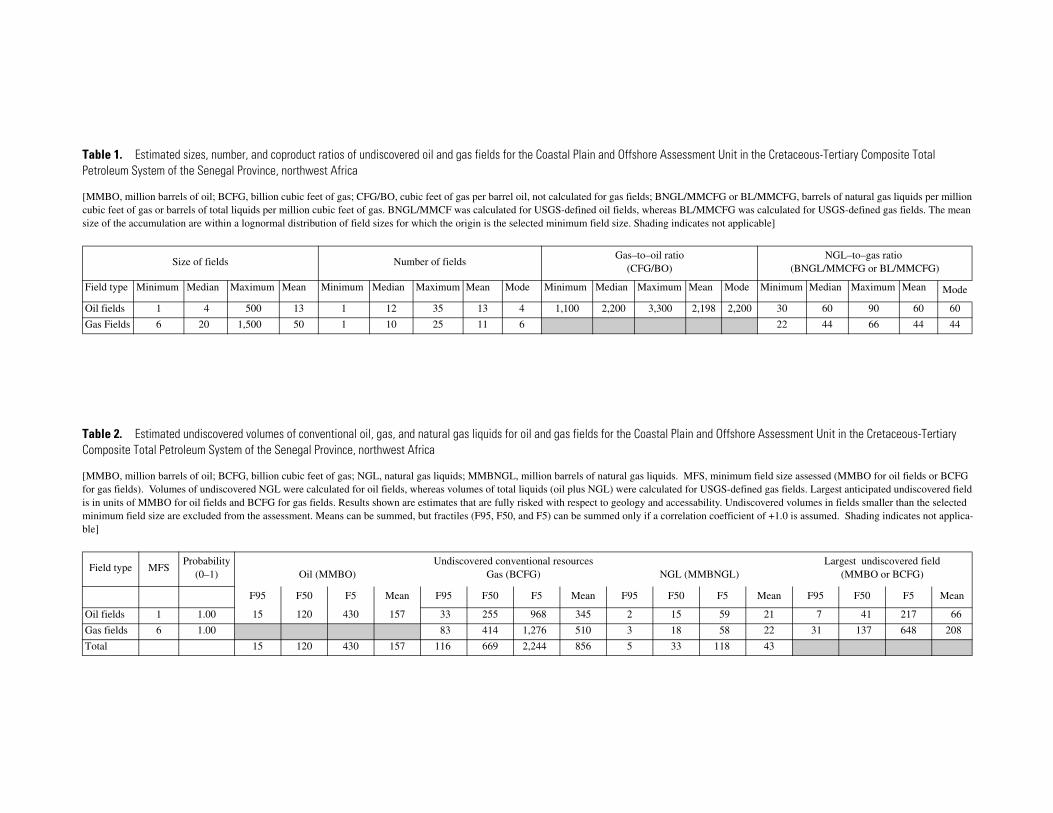
Table 1. Estimated sizes, number, and coproduct ratios of undiscovered oil and gas fields for the Coastal Plain and Offshore Assessment Unit in the Cretaceous-Tertiary Composite Total Petroleum System of the Senegal Province, northwest Africa
[MMBO, million barrels of oil; BCFG, billion cubic feet of gas; CFG/BO, cubic feet of gas per barrel oil, not calculated for gas fields; BNGL/MMCFG or BL/MMCFG, barrels of natural gas liquids per million cubic feet of gas or barrels of total liquids per million cubic feet of gas. BNGL/MMCF was calculated for USGS-defined oil fields, whereas BL/MMCFG was calculated for USGS-defined gas fields. The mean size of the accumulation are within a lognormal distribution of field sizes for which the origin is the selected minimum field size. Shading indicates not applicable]
Size of fields Number of fieldsGas–to–oil ratio
(CFG/BO)NGL–to–gas ratio
(BNGL/MMCFG or BL/MMCFG)
Field type Minimum Median Maximum Mean Minimum Median Maximum Mean Mode Minimum Median Maximum Mean Mode Minimum Median Maximum Mean Mode
Oil fields 1 4 500 13 1 12 35 13 4 1,100 2,200 3,300 2,198 2,200 30 60 90 60 60
Gas Fields 6 20 1,500 50 1 10 25 11 6 22 44 66 44 44
Table 2. Estimated undiscovered volumes of conventional oil, gas, and natural gas liquids for oil and gas fields for the Coastal Plain and Offshore Assessment Unit in the Cretaceous-Tertiary Composite Total Petroleum System of the Senegal Province, northwest Africa
[MMBO, million barrels of oil; BCFG, billion cubic feet of gas; NGL, natural gas liquids; MMBNGL, million barrels of natural gas liquids. MFS, minimum field size assessed (MMBO for oil fields or BCFG for gas fields). Volumes of undiscovered NGL were calculated for oil fields, whereas volumes of total liquids (oil plus NGL) were calculated for USGS-defined gas fields. Largest anticipated undiscovered field is in units of MMBO for oil fields and BCFG for gas fields. Results shown are estimates that are fully risked with respect to geology and accessability. Undiscovered volumes in fields smaller than the selected minimum field size are excluded from the assessment. Means can be summed, but fractiles (F95, F50, and F5) can be summed only if a correlation coefficient of +1.0 is assumed. Shading indicates not applica-ble]
Field type MFSProbability
(0–1) Oil (MMBO)Undiscovered conventional resources
Gas (BCFG) NGL (MMBNGL)Largest undiscovered field
(MMBO or BCFG)
F95 F50 F5 Mean F95 F50 F5 Mean F95 F50 F5 Mean F95 F50 F5 Mean
Oil fields 1 1.00 15 120 430 157 33 255 968 345 2 15 59 21 7 41 217 66
Gas fields 6 1.00 83 414 1,276 510 3 18 58 22 31 137 648 208
Total 15 120 430 157 116 669 2,244 856 5 33 118 43