asx & media release · 2 kavaklitepe gold project – turkey (zenith 30%) two coherent plus 800...
TRANSCRIPT

ASX & MEDIA RELEASE
ASX CODE: ZNC
Exploration / Development
Kavaklitepe Gold - Turkey
Zacatecas Lithium - Mexico
Split Rocks Lithium - Aus
San Domingo Lithium - USA
Burro Creek Lithium – USA
Spencer & Wilson Salt Flat Lithium - USA
Develin Creek Copper-Zinc-Gold
Earaheedy Manganese & Mt Alex
Iron
Details as at 30th Sept 2016
Issued Shares (ZNC) 174.0 m Listed Option (ZNCO) 21.0 m
Unlisted options 3.5 m
Mkt. Cap. ($0.11) A$19.1m
Cash as at 31st Dec 16 A$0.6m
Debt Nil
Directors
Michael Clifford Managing Director Mike Joyce Non Exec Chairman
Stan Macdonald Non Exec Director
Julian Goldsworthy Non Exec Director
Major Shareholders
HSBC Custody. Nom. 7.2% City Corp Nom 6.7 % Nada Granich 6.6 % Abingdon 4.5 % Miquilini 4.5%
QUARTERLY ACTIVITY REPORT
FOR THE PERIOD ENDING 31st DECEMBER 2016
HIGHLIGHTS
Exploration and Development
Kavaklitepe Gold Project Turkey
Successful completion of the maiden short-hole diamond drilling program using a mobile rig at the Kavaklitepe gold project in western Turkey, with sulphide-related gold mineralisation being discovered at both the Discovery Zone and Kuzey Zone, and with near surface high-grade oxide and transition gold mineralisation also intersected at Kuzey.
Drilling completed this year at the Kuzey Zone provided an initial wide spaced test of only 360m of the 900m by 250m gold-in-soil anomaly target. Drill results reported (5th October 2016) include: hole KT-09; an overall 67.7m gold mineralised zone from 46.2 to end of hole at 113.9m (true width unknown) including several zones of higher grade: 18.7m @ 1.7 g/t Au from 50.2m, and 16.0m @ 4.7 g/t Au from 82.1m, (including 8.0 m @ 7.1 g/t Au) with the drill hole ending in mineralisation at 113.9m. Gold mineralisation at the Kuzey Zone remains open to the north and east and is open along strike to the south.
Near surface oxide and transition gold mineralisation is interpreted to occur as a flat lying zone extending over the full 360m length that has been drill tested to date. Better intersections that are considered close to true width of high-grade, near surface, gold mineralisation (previously reported) include: 9.0m @ 5.2 g/t Au from surface, and 7.8m @ 7.3 g/t Au from 3.3m depth.
Gold mineralisation was intersected at the Discovery Zone in a single drill hole test (KT-18A) over a 23.5m interval from 22.5m to 46.0m depth with results including: 9.4m @ 1.5 g/t Au and 3.5m @ 2.1 g/t Au (true width intervals). The near surface gold mineralisation dips to the northwest and is 60m down dip of previously reported continuous roadside surface sample results that include: 21.0m @ 2.7 g/t Au and 27.0m @ 1.4 g/t Au.
Drilling at the Guney Zone intersected a wide zone (30.7 m) of silicified and altered breccia crosscutting a meta-siltstone rock sequence from 54.9m to 85.6m with associated higher concentrations of trace elements arsenic, antimony and silver more similar to those returning significant gold intersections at the Kuzey and Discovery zones.
Kavaklitepe 2017 programs and budgets are currently being finalised.
Lithium Portfolio
Project generation activities culminated in securing 100% interest in three new lithium brine projects in Nevada USA, (Spencer, Wilson Salt Flat) and Mexico (Zacatecas), as well as an exclusive option to earn 100% in the Burro Creek lithium clay project in Arizona USA, near the Company’s 100% owned San Domingo spodumene pegmatite project.
Funding to rapidly advance the lithium projects via drilling in early 2017 is required and the Company is currently assessing various options (including funding internally, potential for spin-off into independent vehicle, or external funding through joint venture) for the financing of its American lithium projects.
Contact Us
Zenith Minerals Australia Limited
Level 2, 33 Ord Street
WEST PERTH WA 6005
PO Box 1426
WEST PERTH WA 6872
Telephone: (08) 9226 1110
Facsimile: (08) 9481 0411
Email: [email protected] Web: www.zenithminerals.com.au
For
per
sona
l use
onl
y

2
KAVAKLITEPE GOLD PROJECT – TURKEY (Zenith 30%)
Two coherent plus 800 metre long, high order gold in soil anomalies (+50 ppb), with peak soil sample values over 1 g/t gold;
Continuous rock chip of 54.0 metres grading 3.33 g/t gold, including 21.5 metres grading 7.2 g/t gold within the northwest soil anomaly (Kuzey Zone);
Continuous rock chip of 21 metres grading 2.67 g/t gold at the Discovery Zone, and 12 metres @ 2.5 g/t gold at the Guney Zone;
Strong chargeable IP geophysical anomaly identified directly beneath high-grade surface rock chip samples (7.68, 22.7 g/t gold) and gold in soil (up to 6.05 g/t gold) at the Kuzey Zone;
2016 drill results include: 16m @ 4.7 g/t, 9m @ 5.2g/t and 7.8m @ 7.3g/t Au.
Zenith Project Locations
Activities During the Quarter During the quarter the maiden short-hole diamond drilling program using a mobile rig was completed at the Kavaklitepe gold project in western Turkey. Zenith considers the program to have been successful with sulphide-related gold mineralisation being discovered at both the Discovery Zone and Kuzey Zone, and with near surface high-grade oxide and transition gold mineralisation also intersected at Kuzey. In summary a total of 2558.5m of drilling was completed in twenty-five short diamond drill holes KT-01 to KT-25, & KT-06A at the three target zones: Kuzey, Discovery and Guney during the 2016 exploration campaign.
Kuzey Zone 11 holes (KT-01 to KT-11, including KT-06A);
ZENITH’S EXPLORATION PROJECTS
For
per
sona
l use
onl
y

3
Guney Zone 11 holes (KT-12 to KT-17 & KT-19 to KT-22 & KT-24 to KT-25) and
Discovery Zone 2 holes (KT-18A and KT-23).
Discovery Zone
Gold mineralisation was intersected at the Discovery Zone in a single drill hole test (KT-18A) over a 23.5m interval from 22.5m to 46.0m depth with results including: 9.4m @ 1.5 g/t Au and 3.5m @ 2.1 g/t Au (true width intervals). The near surface gold mineralisation dips to the northwest and is 60m down dip of previously reported continuous roadside surface sample results that include: 21.0m @ 2.7 g/t Au and 27.0m @ 1.4 g/t Au (Figures 2 & 3). The roadside sampling was conducted as an initial test of the 400m long gold-in-soil anomaly at the Discovery Zone.
The new Discovery Zone gold mineralisation remains open to the northeast and southwest and is open down dip. A second drill hole (KT-23) has now been completed 275m southwest along strike where surface rock chip samples returned up to 2.4g/t Au, intersecting 1.3m @ 1.3 g/t Au within a 17.9m wide altered zone from 17.5m to 35.4m with associated anomalous silver, arsenic and antimony.
Figure 2: Kavaklitepe Discovery Zone Drill Hole Locations, Gold Intersections and Location of Cross Section (A-A’)
These new drill results at the Discovery Zone extend and support high-grade, near surface gold intersections previously reported over +360m strike at the Kuzey Zone located 1.3km to the northwest.
Drilling at the Guney Zone has been technically difficult with seven drill holes KT-12 to KT-17, KT-19 & KT-24 completed as a section across the central portion of the prospect. The drilling intersecting a thick, flat-lying, massive sequence of calc-silicate rocks which contained multiple underground cavities up to 4 metres deep that caused several holes to fail at shallow depths and provided locally only very poor diamond drill core sample recoveries. Hole KT-12 returned 1.2m @ 1.4g/t Au from 12.5m and 1.3m @ 0.6g/t Au from 17.2m before being abandoned in a cavity. The massive calc-silicate rock sequence is not considered a preferred host to gold mineralisation. In contrast drill hole KT-21 drilled on the northern part of the prospect (Figure 6) intersected a wide zone (30.7 m) of silicified and
For
per
sona
l use
onl
y

4
altered breccia crosscutting a meta-siltstone rock sequence from 54.9m to 85.6m with associated higher concentrations of trace elements arsenic, antimony and silver more similar to those returning significant gold intersections at the Kuzey and Discovery zones. Follow-up along strike of this zone will be a priority exploration target in 2017.
Figure 3: Kavaklitepe Discovery Zone Cross Section (A-A’)
Kuzey Zone
Drilling completed this year has provided an initial wide spaced test of only 360m of the 900m by 250m wide Kuzey Zone gold-in-soil anomaly target (Figure 4).
Drill results previously reported (5th October 2016) from the Kuzey Zone include: hole KT-09; an overall 67.7m gold mineralised zone from 46.2 to end of hole at 113.9m (true width unknown) including several zones of higher grade: 18.7m @ 1.7 g/t Au from 50.2m, 16.0m @ 4.7 g/t Au from 82.1m, (including 8.0 m @ 7.1 g/t Au) and 8.8m @ 1.0 g/t Au with the drill hole ending in mineralisation at 113.9m and hole KT-08; an overall 76.0m gold mineralised zone from 12.5m to 88.5m including: 13.4m @ 1.0 g/t Au from 16.1m, 1.5m @ 1.3 g/t Au from 33.0m, 2.0m @ 3.0 g/t Au from 48.8m, 9.5m @ 1.2 g/t Au from 56.8m and 4.0m @ 1.2 g/t Au from 84.5m depth, hole KT-07; 12.9m @ 1.2 g/t Au from surface and hole KT-06A; 6.3m @ 3.6 g/t Au from surface.
These, high-grade, wide, gold intersections in hole KT-09 are particularly significant, as they represent the best sulphide gold mineralisation intersected to date at Kavaklitepe. Mineralisation extends from approximately 35m vertically below surface to a down-hole depth of 113.9m where it remains open (Figure 5). Sulphide gold intersections are down-hole widths as the orientation of that style of mineralisation is currently unknown.
In addition gold mineralisation at the Kuzey Zone remains open to the north and east and is open along strike to the south (Figure 6) where drill holes KT-02, KT03 and KT05 only test a portion of the target zone (80m of width).
Near surface oxide and transition gold mineralisation is interpreted to occur as a flat lying zone extending over the full 360m length that has been drill tested to date. Better intersections that are considered close to true width of high-grade, near surface, gold mineralisation (previously reported) include:
KT-01; 3.5m @ 5.5 g/t Au from surface ;
KT-02; 9.0m @ 5.2 g/t Au from surface ;
KT-03; 7.8m @ 7.3 g/t Au from 3.3m depth ;
KT-05; 1.2m @ 10.8 g/t Au from 14.7m (as part of a 16.9m mineralised zone with lower core recovery)
KT-06; 6.3m @ 4.3 g/t Au from surface and a zone from 58.4m to 73.7m depth including 2.9m @ 1.1 g/t Au and 7.7m @ 1.2 g/t Au;
For
per
sona
l use
onl
y

5
KT-06A ; 6.3m @ 3.6 g/t Au from surface;
KT-07 ; 12.9m @ 1.2 g/t Au from surface;
Reporting cut-off criteria and associated JORC tables are included in ASX release dated 22nd December 2016.
Figure 4: Kavaklitepe Kuzey Zone Drill Hole Locations, Gold Intersections
and Location of Cross Sections (B-B’)
Figure 5: Kavaklitepe Kuzey Zone Cross Section (B-B’)
For
per
sona
l use
onl
y

6
Figure 6: Plan Showing Kavaklitepe Project Gold Geochemistry
Planned Programs at Kavaklitepe
The 2017 exploration programs and budgets are currently being finalised by the joint venture partners.
Background on the Kavaklitepe Project
Columbus Copper discovered mineralization at Kavaklitepe in 2013 by following up a stream sediment anomaly to a stream bed outcrop that returned 5.2 g/t Au. Subsequently a small trench in a nearby road cut returned 2.6 g/t Au over 21.0 metres of exposure. About 1.4 kilometres northwest from the discovery outcrop four samples from a gold bearing breccia zone returned 28.2 g/t, 21.7 g/t, 6.7 g/t and 3.6 g/t Au respectively (Columbus Copper release March 1, 2013). Further rock sampling along a road bank in this zone confirmed the presence of high‐grade gold mineralization returning 54 metres of continuous rock chips with an average grade of 3.3 g/t Au (no gold grade cut-off applied), including 21.5m grading 7.2 g/t Au. A total of 2,127 soil samples were also collected on the Property in 50 metre x 50 metre and 100 metre x 100 metre grids covering an area of approximately 11 square kilometres, of which 176 samples returned gold grades higher than 50 ppb, 112 ‐ higher than 100 ppb and 40 ‐ higher than 250 ppb with 9 of these samples containing more than 1000 ppb (1 g/t) Au. The soil sampling outlined a potentially mineralized zone measuring 850 metres by 250 metres and continuing for another 800 metres to the southwest. There are strong, coincident arsenic and antimony anomalies.
Kavaklitepe Joint Venture
Teck Anadolu Madencilik A.S. (“Teck”), a Turkish subsidiary of Teck Resources Limited, has earned a 70% interest in the Kavaklitepe gold project from Zenith by spending US$700,000 in property expenditures including a minimum of 1500m of drilling. Both companies may continue to explore or develop the property by contributing their pro-rata costs or they may elect to dilute their interests according to a standard industry formula. If Zenith reduces its equity below 10% then the remaining interest is converted to a 5% net profit interest royalty.
For
per
sona
l use
onl
y

7
Zenith’s Lithium Portfolio
The Company has assembled an outstanding 100% owned lithium project portfolio over the past 6 - 12 months, including lithium brine, lithium pegmatite and lithium clay targets in Australia and the Americas.
Lithium projects worldwide are of three types: brines, pegmatites and clays. The major lithium brine operations are located in South America (Chile, Argentina and Bolivia), China and Nevada, USA. Traditionally lithium brines are extracted from salt lakes into surface ponds where they are concentrated by solar evaporation and then fed into a processing facility with output as lithium carbonate for sale to battery manufacturers. The capital required for development is slightly higher than pegmatite or clay hosted lithium projects however these projects have the highest operating margin (Figure A). Zenith’s Mexican and Nevada lithium projects are lithium brine plays. Zenith’s Spencer and Wilson Salt Flat brine projects in Nevada, USA are close to both Tesla’s Gigafactory and to Albermarle Corporation’s Silver Peak-Clayton Valley lithium brine operation, the only operational lithium project in the USA. Zenith’s three new concessions: Illescas, San Juan and San Vicente make up the Zacatecas lithium brine project in the emerging lithium brine district of San Luis Potosi State, Mexico.
Lithium pegmatite projects are exploited as traditional hard rock open pit mines (Greenbushes etc.) where concentrates of the primary lithium mineral spodumene are sold to third party processors who convert the concentrates to lithium compounds suitable for use by battery manufacturers. Pegmatite projects have a lower capital intensity but as they produce a lower value product (spodumene concentrate) they have a lower operating margin than similar sized brine projects. Zenith’s San Domingo project in Arizona contains abundant spodumene bearing lithium pegmatites, and Zenith’s Split Rocks project in the Forrestania Belt in Western Australia is close to the large new spodumene pegmatite discovery Earl Grey containing 128 million tonnes at 1.44% Li2O (Kidman Resources–ASX) .
Zenith’s Burro Creek lithium clay project in Arizona is comparable to other lithium clay projects in the USA and Mexico subject to resource and development studies (e.g: Sonora project (Banacora –TSX).
Zenith’s Nevada, Arizona and Mexico lithium projects are perfectly positioned to provide future supply to the growing USA domestic lithium battery market. Tesla Corporation has commenced construction of its lithium battery manufacturing facility (Gigafactory) outside Reno Nevada, whilst Faraday has set aside land in the Las Vegas industrial park for its battery plant.
Funding to rapidly advance the projects via drilling in early 2017 is required and Zenith is assessing various options (including funding internally through a significant capital raising, spin-off by IPO or back-door listing, or external funding through joint venture etc.) for the financing of its American lithium projects.
Figure A: Lithium Clay, Brine & Spodumene Projects – Forecast Operating Margin versus Capital Efficiency
For
per
sona
l use
onl
y

8
ZACATECAS LITHIUM PROJECT – MEXICO (Zenith 100%)
New tenure (26,000 acres) over extensive system of salt lakes within emerging lithium brine district in central Mexico;
Lithium brines to 2.1% lithium reported in regional sampling program conducted by the Mexican Federal Government from solar evaporation ponds for salt production on adjacent salt lake (10km west of Zenith’s new tenure).
Results confirm lithium enriched source brines are present in the district, as well as demonstrating that concentration of lithium by traditional solar evaporation methods is possible: Four water samples returned 1.2%, 1.4%, 1.4% and 2.1% lithium, these very high-grade lithium brines are similar to post-concentration brine feedstock to lithium brine production facilities;
Initial, limited reconnaissance sampling by Zenith on salt pans covering the Company’s new Zacatecas tenure returned highly anomalous lithium in surface sediments up to 524ppm - comparable to and higher than those from competitor lithium brine projects in Mexico and the USA; and
Geophysical surveying and infill surface sampling in progress, to precede planned drill testing.
Activities Immediately post the quarter the Company announced (ASX release 17th January 2017) that it has staked new 100% owned concessions (totalling 26,440 acres) over a new lithium brine exploration project in central Mexico. The region is generally known for its large scale silver mines and has excellent infrastructure.
Three areas; San Juan, San Vicente and Illescas (covering a total of 26,440 acres) have been applied for with Zenith to hold 100% interest through a Mexican subsidiary. Lithium brines to 2.1% lithium have been taken from small scale, salt production solar evaporation ponds on an adjacent salt lake located 10km west of Zenith’s new tenure. The samples were taken as part of a water and surface sediment sampling program conducted by the Mexican Federal Government - Mineral Resource Council. These results confirm lithium enriched source brines are present in the Zacatecas district, as well as demonstrating that concentration of lithium by traditional solar evaporation methods is possible.
Initial reconnaissance sampling by Zenith returned up to 524ppm lithium in surface sediments on the San Juan salt lake concession and up to 206ppm lithium at Illescas. These results are comparable to and higher than those from many competitor lithium brine exploration projects in the USA and Mexico (Figure 7).
The conceptual deposit model for Zenith’s new Zacatecas lithium brine project is adapted from the known deposits being exploited by other companies in the USA, Chile, Bolivia and Argentina. Water-bearing formations or aquifer types range from deep volcano-sedimentary units within the valley-fill sequence that are saturated in lithium-enriched brine such as at Albemarle’s Clayton Valley operation in Nevada USA to near-surface salt lakes and ponds in the south American lithium operations. Amongst other important geological and hydrological criteria these lithium districts generally contain active hot springs or there is evidence of past geothermal activity such as the presence of sinters (silica rich deposits that occur at hot spring out-flow zones). Existing lithium brine operations have lithium resource grades ranging from 102 milligrams per litre (mg/l) to 1409 mg/l this is roughly equivalent to 80 to 1100ppm lithium. In most cases the lithium brine is pumped into surface ponds and the lithium is concentrated to percent levels by solar evaporation before final treatment in a processing plant to produce lithium carbonate or similar products commonly used by battery manufacturers.
The Zacactecas lithium brine project within the closed El Barril aquifer, with its thick sequence of Tertiary, Cretaceous, and Quaternary age clastic sediments, ash beds and evaporite deposits is prospective for lithium brines. In addition, low average annual rainfall and very high average annual evaporation rates means that traditional methods of solar evaporation of brines are a viable production method. This is also evidenced in the many artisanal table salt production facilities that exploit the brines on several of the salt lakes within this district.
Planned Programs at Zacatecas Ground based geophysical surveying is planned to commence mid-January followed by drilling.
For
per
sona
l use
onl
y

9
SPLIT ROCKS LITHIUM PROJECT – WA (Zenith 100%)
New 100% owned exploration licence application covering ~500sqkm of the Forrestania Greenstone Belt which is host to the new Earl Grey lithium pegmatite discovery;
An ongoing review of previous exploration activity has to date found the majority of exploration focused solely on gold exploration despite the prevalence of mapped pegmatites in the belt.
Zenith’s geologists believe that the new application area is prospective for lithium and gold mineralisation; and
Initial surface mapping and surface sampling to precede planned drill testing.
Figure 7: Zacatecas Lithium Brine Project – Location Map
Activities During the Quarter The Split Rocks Project with 100% owned exploration licence applications covers a large portion (total area ~500sqkm) of the Forrestania Greenstone Belt of Western Australia. This emerging lithium district is host to the new Earl Grey lithium deposit containing 128Mt @ 1.44% Li2O (KDR ASX Release 5th Dec 2016) and to the South Ironcap Lithium Prospect identified by Western Areas Limited (Figure 8).
Zenith’s northern Split Rocks exploration licences are located 10km northwest of the new Earl Grey lithium pegmatite discovery whilst exploration licence applications in the southern portion of the Forrestania Greenstone belt are located 2km west and 5km northwest, respectively, of the South Iron Cap Lithium Prospect where resampling by Western Areas (ASX:WSA) of historic nickel drilling has returned results including 50m @ 0.95% Li2O.
The Company notes that the majority of previous exploration activity reviewed to date covering the new exploration licence applications is surface based focused solely on nickel exploration and only limited fresh rock drilling
For
per
sona
l use
onl
y

10
programs, with no evidence of any lithium analyses during past exploration programs. However, several historic exploration drill holes documented in open file reports did intersect pegmatites in areas within Zenith’s applications and along strike adding significantly to their lithium prospectivity. Sampling of residual surface spoil samples from selected historic drill holes has to date only returned weakly anomalous lithium results, however additional sampling is warranted given that there are abundant pegmatite dykes, many of which are now being shown to be lithium (spodumene) rich within the Forrestania Greenstone Belt.
Planned Programs at Split Rocks Following completion of the review of past exploration, initial surface mapping and follow-up sampling is planned prior to drill testing.
Figure 8: Split Rocks Project Lithium Targets and Tenure
For
per
sona
l use
onl
y

11
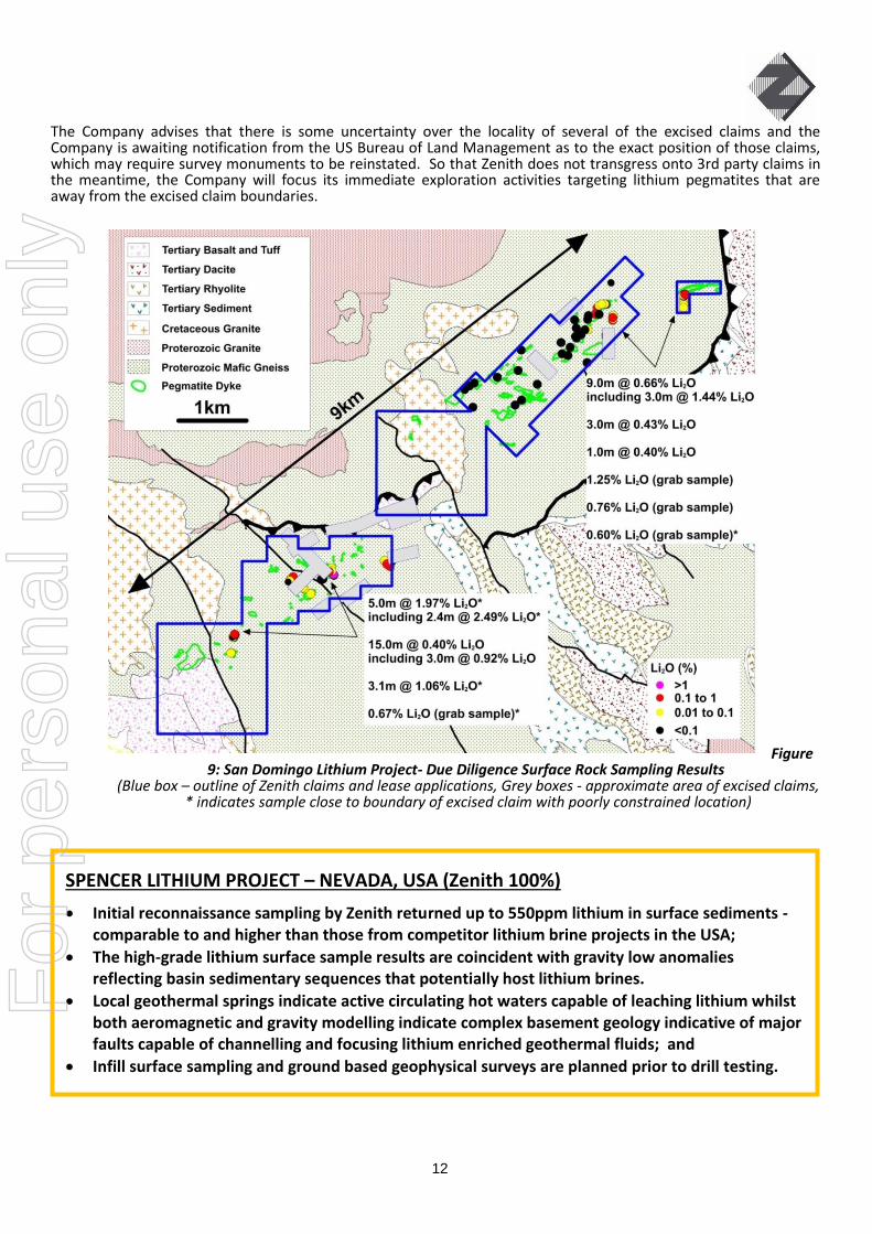
Activities During the Quarter Field reconnaissance mapping was completed during the quarter, 36 samples were collected. Results confirm desktop interpretation that several of the lithium bearing pegmatite bodies extend along strike beyond that identified in previous mapping. In addition sampling of quartz veined volcanic rocks from historic stockpiles adjacent to a 3m deep adit returned gold up to 2.41 g/t. Further follow-up sampling to determine the significance of these preliminary sampling results is planned. Background on San Domingo Project During mid-year (16th June 2016) a wholly owned subsidiary of Zenith Minerals secured a 100% interest in a new lithium exploration project in Arizona, USA. The project covers a 9km by 1.5km lithium-bearing pegmatite dyke swarm that intrudes Proterozoic mafic gneiss host rocks that are in turn locally overlain by Tertiary age volcanic and sedimentary rocks (Figure 9). Initial mapping and sampling by Zenith’s consultants to date has identified 10 lithium bearing pegmatite dykes ranging in outcrop size up to 60m in width and up to 600m in length within the area subject to Zenith’s tenements. First phase continuous rock chip sampling conducted within the new applications has returned very encouraging results up to 5m @ 1.97% Li2O including 2.4m @ 2.49% Li2O from a 14.1m zone grading 1.02% Li2O, and sampling of Lithia King workings returned up to 1.44% Li2O over a 3 metre composite. A further 3 lithium bearing pegmatite dykes are known to occur at least partly within small claims that are believed to be excised from the land recently applied for by Zenith. The pegmatite dykes show clear zonation, with lithium enrichment within the inner ‘’core’’ zones. Historical records refer to spodumene crystals up to 11 feet long at the Lithia King pegmatite (held by Zenith). Lithium (as spodumene and amblygonite concentrates) along with tantalum was produced from small scale mining of the pegmatites within the district during the period 1947 – 1952, historic production of lithium from two small scale mines within Zenith’s claims produced amblygonite concentrates grading from 7.4 to 8.5% Li2O (Arizona Bureau of Mines Bulletin 1952). However the area has been subject to sparse systematic exploration for lithium. No drilling for lithium appears to have been completed since the early 1950s when diamond drilling on 4 of the pegmatite bodies and associated minor surface and underground exploration is mentioned in historical documents. Very little detail on this work has been sighted by the Company, other than partial results from one drillhole and anecdotal information mentioning “..considerable thicknesses of spodumene-bearing pegmatite..” penetrated in several other holes reported by a 3rd party. Since hole locations, sampling details and assay methodology are not known the Company considers the results not to be reportable under the JORC Code. A third party reference to a 1980-82 exploration program for tantalum and niobium does not mention lithium analyses. Planned Programs The Company will conduct additional mapping and sampling prior to planned drill testing. Understanding the size, shape and zoning of the pegmatites, along with distribution, weathering and alteration of lithium bearing minerals will be a focus of Zenith’s future exploration of the district. Mapping and sampling by Zenith and past academic research has noted that surface weathering and alteration of the spodumene crystals occurs in the district, locally reducing their lithium content, at least in the near surface.
SAN DOMINGO LITHIUM PROJECT – ARIZONA USA (Zenith 100%)
100% owned state mineral exploration leases and federal mineral claims cover the San Domingo pegmatite field in Arizona, USA;
Abundant known lithium bearing pegmatite dykes within Zenith’s claims stretching over an area 9km by 1.5km;
Initial continuous rock chip sampling by Zenith’s consultants has returned very encouraging results up to 5m @ 1.97% Li2O including 2.4m @ 2.49% Li2O within 14.1m zone @ 1.02%Li2O from spodumene rich pegmatites; and
Lithium as spodumene and amblygonite concentrates along with tantalum was produced from pegmatites within the district during the period 1947 – 1952.
For
per
sona
l use
onl
y
12
The Company advises that there is some uncertainty over the locality of several of the excised claims and the Company is awaiting notification from the US Bureau of Land Management as to the exact position of those claims, which may require survey monuments to be reinstated. So that Zenith does not transgress onto 3rd party claims in the meantime, the Company will focus its immediate exploration activities targeting lithium pegmatites that are away from the excised claim boundaries.
Figure 9: San Domingo Lithium Project- Due Diligence Surface Rock Sampling Results
(Blue box – outline of Zenith claims and lease applications, Grey boxes - approximate area of excised claims, * indicates sample close to boundary of excised claim with poorly constrained location)
SPENCER LITHIUM PROJECT – NEVADA, USA (Zenith 100%)
Initial reconnaissance sampling by Zenith returned up to 550ppm lithium in surface sediments - comparable to and higher than those from competitor lithium brine projects in the USA;
The high-grade lithium surface sample results are coincident with gravity low anomalies reflecting basin sedimentary sequences that potentially host lithium brines.
Local geothermal springs indicate active circulating hot waters capable of leaching lithium whilst both aeromagnetic and gravity modelling indicate complex basement geology indicative of major faults capable of channelling and focusing lithium enriched geothermal fluids; and
Infill surface sampling and ground based geophysical surveys are planned prior to drill testing.
For
per
sona
l use
onl
y

13
Activities During the Quarter During the quarter the Company announced that it had secured a new 100% owned lithium brine exploration project in central western Nevada, USA – Spencer (ASX Release 16th Dec 2016). The Spencer Project is located in Lander County, Nevada near the lithium production area of Silver Peak-Clayton Valley. The Project is 100% owned by Zenolith (USA) Inc (“Zenolith”) a wholly owned subsidiary of Zenith Minerals Limited, and is located in the North Smoky Basin northwest of White Mountain. The property is comprised of 146 unpatented placer claims in two claim blocks totalling 2,920 acres that were located in November 2016 to encompass highly anomalous lithium in surface sediments and water samples, in close proximity to the Spencer hot spring that lies on the eastern margin of the North Smoky Valley basin, coincident with inferred major basin margin faults. Initial surface sediment samples taken from the salt lake surface by Zenolith are enriched in lithium up to 550ppm (ASX Release 6th December 2016) supporting the hypothesis of lithium brines being present in the sub-surface. The nearby Silver Peak operation in Clayton Valley is currently the only operational USA lithium project. Production by Albemarle Corporation formerly Rockwood Lithium, is facilitated through an extraction system that pumps groundwater enriched in lithium to surface solar evaporation ponds on the property. Evaporation of fluid from the ponds over a period of 12 to 18 months increases the lithium concentration prior to transfer of the concentrated brine to a processing plant for final product development. Tesla’s lithium ion battery production facility (Gigafactory) is under construction nearby, also in Nevada. The conceptual deposit model for Zenith’s Spencer Project is adapted from the known deposits being exploited by Albemarle Corporation at Clayton Valley, where six different water-bearing formations or aquifer types have been identified. These are specific volcano-sedimentary units within the valley-fill sequence that are either saturated in lithium-enriched brine or contain salt or clay minerals with anomalously high concentrations of lithium. In addition, recent lithium brine drilling success by Pure Energy Minerals (TSX-V:PE) in the south of Clayton Valley provides an additional lithium brine host architecture model, whereby basin margin faults along the eastern boundary have a strong control on the host sequences and entrained lithium brines. The geologic setting within the closed Great Basin, with its thick sequence of Quaternary age clastic sediments, ash beds and evaporate deposits is prospective for lithium brines. The geologic formations that compose the surrounding mountain ranges, specifically certain Tertiary-age volcanic formations, contain anomalous concentrations of lithium and are considered one likely source of lithium in brines and sedimentary layers similar to those in the Clayton Valley area. Planned Activities Infill surface sampling along with geophysical surveying followed by drilling are the next steps in exploration of the Spencer project. An initial drilling program is likely and will require permits through the United States Bureau of Land Management (USBLM) and the State of Nevada. The first two holes will be designed to test specific structural and stratigraphic targets identified by the geophysical surveys. Given success with these preliminary exploratory drill holes in finding brine aquifers and anomalous lithium contents, additional holes would be placed to expand on the information relating to basin hydrogeology, leading to resource estimation.
WILSON SALT FLAT LITHIUM PROJECT – NEVADA USA (Zenith 100%)
Initial reconnaissance sampling by Zenith returned up to 192ppm lithium from the surface of a salt lake;
The high-grade lithium surface sample results are coincident with gravity low anomalies reflecting basin sedimentary sequences that potentially host lithium brines.
Both aeromagnetic and gravity modelling indicate complex basement geology indicative of major faults capable of channelling and focusing lithium enriched geothermal fluids; and
Infill surface sampling and ground based electrical geophysical surveys are planned prior to drill testing.
For
per
sona
l use
onl
y

14
Activities During the Quarter During the quarter the Company announced that it had secured a new 100% owned lithium brine exploration projects in central western Nevada, USA – Wilson Salt Flat (ASX Release 16th Dec 2016). The Wilson Salt Flat Project is located in Nye County, Nevada 140km east from the lithium production area of Silver Peak- Clayton Valley. The Project is 100% owned by Zenolith and is located in the Railroad Basin. The property is comprised of 168 unpatented placer claims in a single claim block totalling 3,360 acres that were located in November 2016 to encompass highly anomalous lithium in surface sediment samples coincident with a salt lake and discrete gravity low interpreted to be a closed basin. Initial surface sediment samples taken from the salt lake surface by Zenolith are enriched in lithium up to 192ppm (ASX Release 6th December 2016) supporting the hypothesis of lithium brines being present in the sub-surface (Figure 10). During December 2016 Zenith completed a passive seismic geophysical survey with the aim of confirming the sub-surface architecture of the basin beneath the surface salt lake at Wilson Salt Flat. Data has been received and modelling is near complete and will be the subject of a future ASX release.
Figure 10: Wilson Salt Flat Project - Initial Surface Geochemical Results on Google Earth Image, overlain by Gravity Contours, Major Interpreted Fault Structures
The conceptual deposit model for Zenith’s Wilson Salt Flat Project is adapted from the known deposits being exploited by Albemarle Corporation at Clayton Valley, where six different water-bearing formations or aquifer types have been identified. These are specific volcano-sedimentary units within the valley-fill sequence that are either saturated in lithium-enriched brine or contain salt or clay minerals with anomalously high concentrations of lithium. In addition, recent lithium brine drilling success by Pure Energy Minerals (TSX-V:PE) in the south of Clayton Valley provides an additional lithium brine host architecture model, whereby basin margin faults along the eastern boundary have a strong control on the host sequences and entrained lithium brines. The geologic setting within the closed Great Basin, with its thick sequence of Quaternary age clastic sediments, ash beds and evaporate deposits is prospective for lithium brines. The geologic formations that compose the surrounding mountain ranges, specifically certain Tertiary-age volcanic formations, contain anomalous concentrations of lithium and are considered one likely source of lithium in brines and sedimentary layers similar to those in the Clayton Valley area.
For
per
sona
l use
onl
y

15
Planned Activities Infill surface sampling along with ground based electrical geophysical surveying followed by drilling are the next steps in exploration of the Wilson Salt Flat project. An initial drilling program is likely and will require permits through the United States Bureau of Land Management (USBLM) and the State of Nevada. The first two holes will be designed to test specific structural and stratigraphic targets identified by the geophysical surveys. Given success with these preliminary exploratory drill holes in finding brine aquifers and anomalous lithium contents, additional holes would be placed to expand on the information relating to basin hydrogeology, leading to resource estimation.
Activities During the Quarter On the 10th November the Company announced that it had secured an exclusive option to acquire a 100% interest in the Burro Creek lithium clay project located in central western Arizona, USA. Located in an active mining district, Freeport McMoRan’s operating Bagdad porphyry copper mine is located 10km from the Burro Creek project. Initial surface sampling by the Company of the lithium clay exposures (reported 10th November 2016) returned results including: 20m @ 818ppm Li, 5m @ 1090ppm Li and 15m @ 930ppm Li & 50m @ 785 ppm Li. Follow-up sampling was completed during the quarter with results received shortly after the quarter and announced to the market on the 13th January 2017. New results from that follow-up program returned generally higher-grade lithium results over greater widths (Figure 11).
Results from composite channel sampling of zones where the full clay thickness is exposed in the field included: 33.6m @ 980ppm Li; whilst,
Zones where lithium bearing clay zones are not fully exposed and are locally obscured by transported rubble and alluvium included: 15m @ 1427ppm Li and 15m @ 920ppm Li; 2.5m @ 1300ppm Li, 3.5m @ 1120ppm Li and 1.5m @ 1210ppm Li. These results represent only a portion of the lithium clay horizon and drilling or trenching is required to test the full thickness of the lithium bearing units; and
Grab samples of relict drill spoil from shallow holes drilled during a small, historical program to test the clay for industrial purposes returned results including: 1650ppm Li and 1290ppm Li. Encouragingly these are among the highest grades returned from Zenith’s sampling to date and may indicate that surface sampling is understating the true lithium grade. True widths for these zones are unknown and follow-up drilling is required.
A trial geophysical survey using passive seismic technique supports Zenith’s geological interpretation of extensive flat lying, near surface lithium bearing clays.
The lithium bearing clay zone is a near surface, flat lying horizon extending over 1700m by 1000m within the eastern project leases and a further 800m by 600m within the western lease areas. Observations from mapping and sampling programs indicate that the clay horizon generally has a true thickness greater than 30 m where it is exposed in gullies within gently undulating, poorly vegetated hills that comprise the eastern project area. Previous drilling to test the
BURRO CREEK LITHIUM PROJECT – ARIZONA, USA (Zenith Option to Earn 100%)
Large scale lithium (Li) clay target under exclusive option in Arizona, USA;
Follow-up surface sampling returned high-grade lithium results of widths up to 33.6m metres at 980 ppm Li, and 15m @ 1427 ppm Li. These results are comparable to competitor lithium clay projects in USA and Mexico that are subject to feasibility studies and trial processing plants respectively;
Recent geological mapping and seismic geophysical surveys confirm extensive zones of shallow dipping lithium bearing clay with true thickness up to 50 metres;
Based on the positive outcomes of work completed during the initial due diligence period Zenith has resolved to exercise its option to proceed with the project; and
Metallurgical testwork ongoing to assess ease of extracting lithium. Drilling planned.
For
per
sona
l use
onl
y

16
clay quality for industrial uses intersected clay units over thicknesses up to 20m in the western half of the project area, notwithstanding that drilling did not penetrate the full thickness of those clay beds which are up to 50 m thick in outcrop in the eastern area. The Company therefore concludes that there is excellent potential for large tonnages of lithium bearing clay within the Burro Creek project.
Figure 11: Burro Creek Sample Location and Results Map
(Enlargement - East Burro Creek Sample Results) Planned Activities Initial metallurgical testwork is currently in progress at a facility in Colorado, USA, comprising a bulk clay sample taken from the Burro Creek project area. Testwork will focus on the lithium solubility using various techniques documented at other lithium clay projects such as at Bacanora Minerals Limited’s Sonora lithium clay project in Mexico, which is currently at the feasibility stage. If metallurgical testwork on the Burro Creek bulk sample is acceptable then the Company considers that initial trenching and wide-spaced drill testing would likely lead towards rapid resource definition. Trench and drill program designs have been completed and permits will be submitted to the State of Arizona in early 2017.
For
per
sona
l use
onl
y

17
Activities During the Quarter Negotiating Native Title/Heritage access agreements.
Planned Activities Zenith’s geologists believe that the new application area is prospective for lithium mineralisation. Following completion of the review of past exploration, initial surface mapping and sampling is planned prior to drill testing.
Background on Pollappa Project Large area (333 square kilometres) of 100% owned exploration permit for minerals applications (EPMA’s) in north Queensland, Pollappa Lithium Project (ASX Release 15th September 2016). An initial area was applied for in early July 2016 following the recognition by the Company that the region contained lithium-enriched granites (Kintore Supersuite) and lithium-mineralised rocks with samples returning highly anomalous lithium values grading: 0.50% Li2O, 0.48% Li2O, 0.46% Li2O and 0.40% Li2O, from schist samples (not pegmatites) ascribed to the Holroyd Group metamorphic rocks. Those samples were documented in an Australian Federal Government geochemical sampling database of 50,000 records that were assessed by the Company as part of its Australia wide lithium project generation study.
The initial EPMA area was subsequently augmented by a second larger EPMA in early August after the lifting of a statutory moratorium period by the Queensland Department of Natural Resources and Mines following the relinquishment of an earlier EPM.
POLLAPPA LITHIUM PROJECT – QLD (Zenith 100%)
Two 100% owned tenements covering 333 square kilometres (40km of strike) of lithium
prospective rocks in north Queensland - Pollappa Project;
Area targeted using in-house Company methodology to assess the lithium fertility of host rock
sequence and granites Australia wide;
Highly anomalous lithium values grading: 0.50% Li2O, 0.48% Li2O, 0.46% Li2O and 0.40% Li2O from
Holroyd Group metamorphic rock samples, located centrally within the new application areas;
Majority of previous exploration focused solely on base metals and gold exploration despite the
description of mapped pegmatites and lepidolite occurrence in the belt; and
Zenith’s geologists believe that the area is prospective for lithium mineralisation.
For
per
sona
l use
onl
y
18
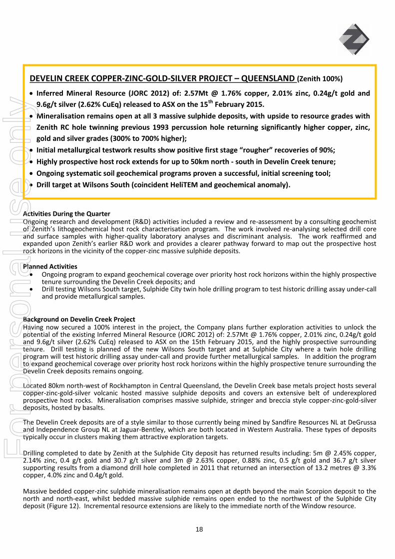
Activities During the Quarter Ongoing research and development (R&D) activities included a review and re-assessment by a consulting geochemist of Zenith’s lithogeochemical host rock characterisation program. The work involved re-analysing selected drill core and surface samples with higher-quality laboratory analyses and discriminant analysis. The work reaffirmed and expanded upon Zenith’s earlier R&D work and provides a clearer pathway forward to map out the prospective host rock horizons in the vicinity of the copper-zinc massive sulphide deposits. Planned Activities Ongoing program to expand geochemical coverage over priority host rock horizons within the highly prospective
tenure surrounding the Develin Creek deposits; and Drill testing Wilsons South target, Sulphide City twin hole drilling program to test historic drilling assay under-call
and provide metallurgical samples. Background on Develin Creek Project Having now secured a 100% interest in the project, the Company plans further exploration activities to unlock the potential of the existing Inferred Mineral Resource (JORC 2012) of: 2.57Mt @ 1.76% copper, 2.01% zinc, 0.24g/t gold and 9.6g/t silver (2.62% CuEq) released to ASX on the 15th February 2015, and the highly prospective surrounding tenure. Drill testing is planned of the new Wilsons South target and at Sulphide City where a twin hole drilling program will test historic drilling assay under-call and provide further metallurgical samples. In addition the program to expand geochemical coverage over priority host rock horizons within the highly prospective tenure surrounding the Develin Creek deposits remains ongoing. Located 80km north‐west of Rockhampton in Central Queensland, the Develin Creek base metals project hosts several copper-zinc-gold-silver volcanic hosted massive sulphide deposits and covers an extensive belt of underexplored prospective host rocks. Mineralisation comprises massive sulphide, stringer and breccia style copper-zinc-gold-silver deposits, hosted by basalts. The Develin Creek deposits are of a style similar to those currently being mined by Sandfire Resources NL at DeGrussa and Independence Group NL at Jaguar-Bentley, which are both located in Western Australia. These types of deposits typically occur in clusters making them attractive exploration targets. Drilling completed to date by Zenith at the Sulphide City deposit has returned results including: 5m @ 2.45% copper, 2.14% zinc, 0.4 g/t gold and 30.7 g/t silver and 3m @ 2.63% copper, 0.88% zinc, 0.5 g/t gold and 36.7 g/t silver supporting results from a diamond drill hole completed in 2011 that returned an intersection of 13.2 metres @ 3.3% copper, 4.0% zinc and 0.4g/t gold. Massive bedded copper-zinc sulphide mineralisation remains open at depth beyond the main Scorpion deposit to the north and north-east, whilst bedded massive sulphide remains open ended to the northwest of the Sulphide City deposit (Figure 12). Incremental resource extensions are likely to the immediate north of the Window resource.
DEVELIN CREEK COPPER-ZINC-GOLD-SILVER PROJECT – QUEENSLAND (Zenith 100%)
Inferred Mineral Resource (JORC 2012) of: 2.57Mt @ 1.76% copper, 2.01% zinc, 0.24g/t gold and
9.6g/t silver (2.62% CuEq) released to ASX on the 15th February 2015.
Mineralisation remains open at all 3 massive sulphide deposits, with upside to resource grades with
Zenith RC hole twinning previous 1993 percussion hole returning significantly higher copper, zinc,
gold and silver grades (300% to 700% higher);
Initial metallurgical testwork results show positive first stage “rougher” recoveries of 90%;
Highly prospective host rock extends for up to 50km north - south in Develin Creek tenure;
Ongoing systematic soil geochemical programs proven a successful, initial screening tool;
Drill target at Wilsons South (coincident HeliTEM and geochemical anomaly).
For
per
sona
l use
onl
y

19
Figure 12: Sulphide City Deposit – Cross Sections
In addition a Zenith RC hole completed in the drill program twinned a 1993 percussion drill hole as the older hole appeared to have anomalously low results compared to the more recent diamond drill holes and other older 1993 diamond drill hole results further to the north. Zenith’s new hole returned significantly higher copper, zinc, gold and silver grades (3x copper, 5x zinc, 5x gold and 7x silver) for the equivalent drilled interval. Results from the newer twin hole replaced the older drill hole results allowing a zone of continuous high-grade copper to be defined through the core of the Sulphide City deposit. The Sulphide City mineralisation consists of stockwork, disseminated and massive sulphide mineralisation. The main Sulphide City lens, outlined with a 1% copper equivalent cut-off, has a horizontal projection of about 400m x 150m. The lens varies from 2.5m to 29m in thickness, generally dips 25-30° west-northwest and has been intersected at depths between 80m and 200m. Better historic drill intersections (previously reported) include: • DDH-016 14.5m @ 0.6% Cu and 4.3% Zn (includes 2.5m @ 12.0% Zn) • DDH-044 11.3m @ 2.1% Cu, 5.9% Zn, 16g/t Ag & 1.21g/t Au • PD-052 15.0m @ 3.1% Cu, 2.3% Zn
The Scorpion deposit, 500m south-west of the Sulphide City deposit occurs in a 400m x 200m zone in altered volcanic rocks. The sulphide body, 2.5m – 9.5m thick consists of brecciated massive sulphides and grades up to 6% Cu, 9% Zn, 43g/t Ag and 1g/t Au. Better historic drill results (previously reported) include:
• DDH-001 21.6m @ 2.5% Cu, 1.5% Zn, 13g/t Ag & 0.5g/t Au (includes 16.2m @ 3.2% Cu, 1.6% Zn) • DDH-002 31.6m @ 1.5% Cu, 1.5% Zn, 15g/t Ag & 0.3g/t Au (includes 16.7m @ 2.1% Cu, 2.0% Zn) • PD-007 44.0m @ 1.6% Cu, 1.0% Zn, 8g/t Ag & 0.3g/t Au (includes 25.0m @ 2.6% Cu, 1.2% Zn)
The highly weathered Window mineralisation consists of a ~40m thick sub-horizontal supergene blanket of copper mineralisation at 50m depth within a wider zone of stringer style mineralisation. The location and style of mineralisation indicates that the Window Deposit may be the partially eroded footwall stringer zone to the nearby Scorpion massive sulphide lenses. Better historic drilling results from Window (previously reported) include: • PD-012 84.0m @ 0.8% Cu (includes 48.0m @ 1.2%)
For
per
sona
l use
onl
y

20
Wilsons South Prospect
In the Wilsons area, located 30km south of the known Develin Creek copper-zinc-gold-silver deposits Zenith’s geochemical sampling program defined a 1000 metre by 500 metre, coincident copper-zinc soil anomaly overlying the Wilsons Copper Prospect where samples of gossans (up to 2.7% copper and 0.4% zinc) were mapped. Based on mapping and historical drilling Zenith’s geologists interpret the Wilsons Prospect to represent the footwall stringer or feeder position typically observed below copper-zinc massive sulphide bodies.
In addition to identifying the known prospect at Wilsons, the soil sampling defined a prospective corridor 2000 metres by 750 metres continuing to the south which overlies a discrete EM conductor defined by a HeliTEM geophysical survey. The coincident soil anomaly and EM conductor at Wilsons South are located at higher topographic elevations directly along geological strike from the Wilsons prospect and are therefore considered to be an attractive drill target as preservation of the copper-zinc massive sulphide bodies are considered likely.
Regional Targets
Within the Develin Creek project area, Zenith believes that there is good potential to discover new massive sulphide copper-zinc mineralisation, in the extensive landholdings totalling 300km2. Zenith controls over 50km of strike length of prospective volcanic host rock sequence.
To date approximately 11,100 soil samples have been collected and analysed by Zenith as part of a systematic geochemical surveying program. Historically there has been little to no systematic geochemical soil sampling over much of the prospective target horizons, and thus Zenith’s ongoing sampling program is the first to provide effective regional geochemical coverage over key portions of the target area.
Activities During the Quarter Nil this quarter.
Background on Mt Alexander Project The Mount Alexander Project is 120 km from the port of Onslow, and 260 km south west of Karratha in the West Pilbara region of Western Australia, close to the Pilbara coast, the sealed North West Coastal Highway and the Dampier Bunbury gas pipeline. Zenith has discovered magnetite iron mineralisation occurs in a banded iron formation (BIF) associated with a sequence of amphibolite, dolomite, schist and quartzite of Proterozoic age in the northern Gascoyne Province. In May 2013 the Company announced an Inferred Mineral resource for magnetite iron at Mount Alexander of 535 million tonnes @ 30.0% Fe. This mineral resource was updated and reported in June 2015 to include magnetite iron zones that extend on to an exploration licence acquired post that May 2013 resource estimate. The new Inferred Mineral resource (JORC12) for magnetite iron at Mount Alexander is: 565.7 million tonnes @ 30.0% Fe. The resource is the total of the 2013 Inferred Mineral Resource (535.1Mt @ 30.0%Fe) and the updated BIF extensions of the central and south west domains (30.6Mt @ 30.0% Fe). Details are included in JORC Code Reporting Criteria Section 2 of the June 2015 Quarterly Report.
MT ALEXANDER IRON PROJECT – WA (Zenith 100%)
Advantages over other WA magnetite deposits;
o Location close to coast and infrastructure (Well located close to sealed roads, gas pipelines and only 120km from coast near Onslow (Mitsui, Chevron ports)
o Coarser grained = better beneficiation o Low waste to ore ratio ~ 1:1, provides a good compact mining shape
JORC Inferred Resource of 566Mt @ 30 % Fe is only ~ 50% of target iron formation (“BIF”) area. Clear potential to grow resource within significant additional Exploration Target.
For
per
sona
l use
onl
y
21
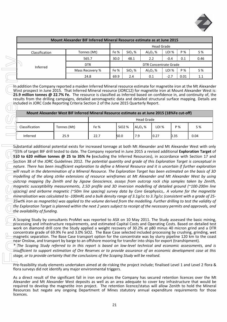
Mount Alexander BIF Inferred Mineral Resource estimate as at June 2015
Head Grade
Classification Tonnes (Mt) Fe % SiO2 % Al2O3 % LOI % P % S %
Inferred
565.7 30.0 48.1 2.2 -0.4 0.1 0.46
DTR DTR Concentrate Grade
Mass Recovery % Fe % SiO2 % Al2O3 % LOI % P % S %
24.8 69.9 2.4 0.1 -2.7 0.01 1.1
In addition the Company reported a maiden Inferred Mineral resource estimate for magnetite iron at the Mt Alexander West prospect in June 2015. That Inferred Mineral resource (JORC12) for magnetite iron at Mount Alexander West is: 25.9 million tonnes @ 22.7% Fe. The resource is classified as Inferred based on confidence in, and continuity of, the results from the drilling campaigns, detailed aeromagnetic data and detailed structural surface mapping. Details are included in JORC Code Reporting Criteria Section 2 of the June 2015 Quarterly Report.
Mount Alexander West BIF Inferred Mineral Resource estimate as at June 2015 (18%Fe cut-off)
Head Grade
Classification Tonnes (Mt) Fe % SiO2 % Al2O3 % LOI % P % S %
Inferred 25.9 22.7 50.0 7.9 0.27 0.35 0.04
Substantial additional potential exists for increased tonnage at both Mt Alexander and Mt Alexander West with only ~55% of target BIF drill tested to date. The Company reported in June 2015 a revised additional Exploration Target of 510 to 620 million tonnes @ 25 to 35% Fe (excluding the Inferred Resources), in accordance with Section 17 and Section 38 of the JORC Guidelines 2012. The potential quantity and grade of this Exploration Target is conceptual in nature. There has been insufficient exploration to define a Mineral Resource and it is uncertain if further exploration will result in the determination of a Mineral Resource. The Exploration Target has been estimated on the basis of 3D modelling of the along strike extensions of resource wireframes at Mt Alexander and Mt Alexander West by using outcrop mapping (by Zenith and by Jigsaw Geoscience, assays from outcrop rock chip samples taken by Zenith, magnetic susceptibility measurements, 2.5D profile and 3D inversion modelling of detailed ground (~100-200m line spacing) and airborne magnetic (~50m line spacing) survey data by Core Geophysics,. A volume for the magnetite mineralisation was calculated to -100mRL and a bulk density range of 3.1g/cc to 3.7g/cc (consistent with a grade of 25-35wt% iron as magnetite) was applied to the volume derived from the modelling. Further drilling to test the validity of the Exploration Target is planned within the next 2 years subject to receipt of the necessary permits and approvals, and the availability of funding. A Scoping Study by consultants ProMet was reported to ASX on 10 May 2011. The Study assessed the basic mining, processing and infrastructure requirements, and estimated Capital Costs and Operating Costs. Based on detailed test work on diamond drill core the Study applied a weight recovery of 30.2% at p80 minus 40 micron grind and a DTR concentrate grade of 69.9% Fe and 3.0% SiO2. The Base Case selected included processing by crushing, grinding, wet magnetic separation. The Base Case transport option for the concentrate was by slurry pipeline 120 km to the coast near Onslow, and transport by barge to an offshore mooring for transfer into ships for export (transhipment). * The Scoping Study referred to in this report is based on low-level technical and economic assessments, and is insufficient to support estimation of Ore Reserves or to provide assurance of an economic development case at this stage, or to provide certainty that the conclusions of the Scoping Study will be realised. Pre-feasibility study elements undertaken aimed at de-risking the project include; finalised Level 1 and Level 2 flora & flora surveys did not identify any major environmental triggers. As a direct result of the significant fall in iron ore prices the Company has secured retention licences over the Mt Alexander and Mt Alexander West deposits as well as an area adequate to cover key infrastructure that would be required to develop the magnetite iron project. The retention licence/status will allow Zenith to hold the Mineral Resources but negate any ongoing Department of Mines statutory annual expenditure requirements for those licences.
For
per
sona
l use
onl
y

22
Activities During the Quarter Nil this quarter. Planned Activities The Company noted that manganese production has been suspended at two of Australia’s premier manganese operations: Woodie Woodie in Western Australia and Bootu Creek in the Northern Territory. As a direct result of the significant fall in manganese prices the Company reduced its landholdings to key exploration targets and holds two Mineral Resources under retention licences. These licences allow Zenith to hold the resources but negate any Department of Mines statutory annual expenditure requirements for those projects. Background on Earaheedy Project The Proterozoic aged Earaheedy Basin north of Wiluna in Western Australia is a potential new manganese province with similarities to the giant Kalahari manganese field in South Africa. As first mover Zenith established a strong land position with tenements. Zenith’s priority target is high-grade (>40% Mn) manganese oxide formed by weathering or supergene upgrade of primary mineralisation. Zenith completed the first ever drilling for manganese in the western Earaheedy in late 2010 at the Lockeridge prospect, intersecting a shallow dipping bed of primary manganese carbonate mineralisation. Better results from Lockeridge include: 12m @ 11.1% Mn from 28m depth, and 3m @ 18.0% Mn from 37m depth. Primary manganiferous carbonate at Lockeridge is supergene enriched near surface. Previous Zenith drilling completed in 2010 was stepped out more than 250 metres down dip from the outcrop, and intersected primary manganiferous carbonate with Mn grades in the range 3 to 10% Mn for up to 1.2 km down dip. The 2013 program established potential for supergene manganese oxide with both holes intersecting mineralisation. Hole ZTAC026 (3m @ 25.1% Mn incl. 1m @ 29.6%) intersected the target around 100 metres down dip from the high grade outcrop, and hole ZTAC025 (3m @ 20.2% Mn) hit partially oxidised mineralisation around 150m down dip from surface outcrop. The first DSO grade Mn drill intersections recorded in the Earaheedy Basin were reported by Zenith in 2012 at the Red Lake prospect. Drilling results include; 3m @ 41% Mn (within 5m @ 34.8% Mn from 22m depth), and 3 metres @ 34.8% Mn from 19 metres, including 1m @ 42.3% Mn. Subsequent drill programs defined continuous near surface high-grade manganese at Red Lake. Based on a revised geological interpretation (ASX Release 9th September 2014) the Red Lake resource is: 1.4Mt @ 19.0% Mn at a 10% Mn cut-off grade with a higher grade component of 0.2Mt @ 30.0% Mn at a 25% Mn cut-off grade as presented in the Table below. The resource is classified under the JORC Code 2012 as Inferred, based on confidence in, and continuity of, the results from the drilling campaigns, and surface mapping.
Red Lake Manganese Mineral Resource Estimate as at August 2014 Classification Reporting Cut-off Grade Tonnes (Mt) Mn % Fe % Si % Al2O3 % P % S % LOI %
Inferred 25% Mn 0.2 30.0 14.1 13.85 7.9 0.24 0.03 12.1
20% Mn 0.5 25.1 16.1 17.0 8.9 0.25 0.06 11.9
15% Mn 1.1 20.8 17.7 20.5 9.3 0.24 0.17 11.5
10% Mn 1.4 19.0 19.1 20.8 9.6 0.26 0.19 11.4
On the 15th April 2015 Zenith reported an Inferred Mineral Resource (JORC 12) for the near surface oxide portion of the Lockeridge manganese prospect. The maiden estimate is: 2.6Mt @ 20.6% Mn at a 10%Mn cut-off grade as presented in the Table below. The resource is classified under the JORC Code 2012 as Inferred, based on confidence in, and continuity of, the results from the drilling campaigns, and surface mapping.
EARAHEEDY MANGANESE PROJECT – WA (Zenith 100%)
Manganese Mineral Resources at Red Lake and Lockeridge are retained under retention licences.
For
per
sona
l use
onl
y

23
Lockeridge Manganese Mineral Resource Estimate as at April 2015 Classification Reporting Cut-off Grade Tonnes (Mt) Mn % Fe % Si02% Al2O3 % P % S % LOI %
Inferred 20% Mn 1.0 30.2 7.0 18.9 4.1 0.12 0.01 5.7
15% Mn 1.9 23.4 6.7 25.4 4.7 0.15 0.01 10.4
10% Mn 2.6 20.6 6.9 27.6 5.1 0.16 0.01 12.0
Note: The Mineral Resource was estimated within constraining wireframe solids based on the specified nominal lower cut-off grade for Mn. The
Mineral Resource is quoted from all blocks above the specified Mn cut-off grade %. Differences may occur due to rounding.
The Mt Minnie Project did not met the Company’s investment criteria and has now been relinquished.
The Company will continue to assess resource projects that have both synergies with existing Zenith projects or that will enhance the Company’s existing project portfolio. There are currently no significant new projects under review or consideration as the immediate Company focus is in advancing the existing high-quality project portfolio, through active exploration. It is envisaged that subject to funding, significant drill programs will be completed at multiple projects during 2017.
The Company held its annual general meeting of shareholders on the Thursday 24th November 2016 at the Celtic Club West Perth, WA.
Zenith Minerals Limited 30th January 2017
For further information contact;
Directors Michael Clifford or Mike Joyce
Phone 08 9226 1110
The information in this report that relates to Zenith Exploration Results and Exploration Targets is based on information compiled by Mr Michael Clifford, who is a Member of the Australian Institute of Geoscientists and an employee of Zenith. Mr Clifford has sufficient experience which is relevant to the style of mineralisation and type of deposit under consideration and to the activity which he is undertaking to qualify as a Competent Person as defined in the 2012 Edition of the 'Australasian Code for Reporting of Exploration Results, Mineral Resources and Ore Reserves'. Mr Clifford consents to the inclusion in the report of the matters based on his information in the form and context in which it appears. The information in this Report that relates to in-situ Mineral Resources at the Develin Creek project is based on information compiled by Ms Fleur Muller an employee of Geostat Services Pty Ltd. Ms Muller takes overall responsibility for the Report. She is a Member of the AusIMM and has sufficient experience, which is relevant to the style of mineralisation and type of deposit under consideration, and to the activity she is undertaking, to qualify as a Competent Person in terms of the ‘Australasian Code for Reporting of Exploration Results, Mineral Resources and Ore
NEW OPPORTUNITIES
CORPORATE
OTHER
COMPETENT PERSONS STATEMENTS
For
per
sona
l use
onl
y

24
Reserves (JORC Code 2012 Edition). Ms Muller consents to the inclusion in the report of the matters based on her information in the form and context in which it appears. The information in this report that relates to Mineral Resources at Zenith’s Red Lake Earaheedy project is based on information compiled by Mr Dmitry Pertel, a Competent Person who is a fulltime employee of CSA Global Pty Ltd and a member of the Australian Institute of Geoscientists (AIG). Mr Pertel has sufficient experience relevant to the style of mineralisation and type of deposit under consideration and to the activity which he is undertaking to qualify as a Competent Person as defined in the 2012 Edition of the “Australasian Code for Reporting of Mineral Resources and Ore Reserves”. Mr Pertel consents to the inclusion of such information in this report in the form and context in which it appears. The information in this report that relates to Mineral Resources at Zenith’s Lockeridge - Earaheedy project, Mt Alexander project and Mt Alexander West project is based on information compiled by Mr Rodney Michael Joyce, a Competent Person who is a director of the Company and a Member of the AusIMM. Mr Joyce has sufficient experience relevant to the style of mineralisation and type of deposit under consideration and to the activity which he is undertaking to qualify as a Competent Person as defined in the 2012 Edition of the “Australasian Code for Reporting of Mineral Resources and Ore Reserves”. Mr Joyce consents to the inclusion of such information in this report in the form and context in which it appears. The information in this report that relates to Zenith Exploration Targets at Mt Alexander is based on information compiled by R M Joyce, who is a director of the Company and a Member of the AusIMM. Mr Joyce has sufficient experience which is relevant to the style of mineralisation and type of deposit under consideration and to the activity which he is undertaking to qualify as a Competent Person as defined in the 2012 Edition of the 'Australasian Code for Reporting of Exploration Results, Mineral Resources and Ore Reserves'. Mr Joyce consents to the inclusion in the report of the matters based on his information in the form and context in which it appears. This information was prepared and first disclosed under the JORC Code 2004. It has not been updated since to comply with the JORC Code 2012 on the basis that the information has not materially changed since it was last reported.
For
per
sona
l use
onl
y

Appendix 5B Mining exploration entity and oil and gas exploration entity quarterly report
+ See chapter 19 for defined terms 1 September 2016 Page 1
+Rule 5.5
Appendix 5B
Mining exploration entity and oil and gas exploration entity quarterly report
Introduced 01/07/96 Origin Appendix 8 Amended 01/07/97, 01/07/98, 30/09/01, 01/06/10, 17/12/10, 01/05/13, 01/09/16
Name of entity
Zenith Minerals Limited
ABN Quarter ended (“current quarter”)
96 119 397 938 31 December 2016
Consolidated statement of cash flows Current
Quarter $A’000
Year to Date
(6 months) $A’000
1. Cash flows from operating activities
7 14 1.1 Receipts from customers
1.2 Payments for
(171) (360) (a) exploration & evaluation
(b) development - -
(c) production - -
(d) staff costs (117) (207)
(e) administration and corporate costs (56) (178)
1.3 Dividends received (see note 3) - -
1.4 Interest received 1 3
1.5 Interest and other costs of finance paid - -
1.6 Income taxes paid - -
1.7 Research and development refunds - -
1.8 Other (provide details if material) - -
1.9 Net cash from / (used in) operating activities
(336) (728)
2. Cash flows from investing activities
- -
2.1 Payments to acquire:
(a) property, plant and equipment
(b) tenements (see item 10) (180) (261)
(c) investments - -
(d) other non-current assets - -
For
per
sona
l use
onl
y

Appendix 5B Mining exploration entity and oil and gas exploration entity quarterly report
+ See chapter 19 for defined terms 1 September 2016 Page 2
Consolidated statement of cash flows Current
Quarter $A’000
Year to Date
(6 months) $A’000
2.2 Proceeds from the disposal of:
- - (a) property, plant and equipment
(b) tenements (see item 10) - -
(c) investments - -
(d) other non-current assets - -
2.3 Cash flows from loans to other entities - -
2.4 Dividends received (see note 3) - -
2.5 Other (provide details if material) - -
2.6 Net cash from / (used in) investing activities
(180) (261)
3. Cash flows from financing activities
- - 3.1 Proceeds from issues of shares
3.2 Proceeds from issue of convertible notes - -
3.3 Proceeds from exercise of share options 111 111
3.4 Transaction costs related to issues of shares, convertible notes or options
- -
3.5 Proceeds from borrowings - -
3.6 Repayment of borrowings - -
3.7 Transaction costs related to loans and borrowings
- -
3.8 Dividends paid - -
3.9 Other (provide details if material) - -
3.10 Net cash from / (used in) financing activities
111 111
4. Net increase / (decrease) in cash and cash equivalents for the period
1,000 1,473 4.1 Cash and cash equivalents at beginning of
period
4.2 Net cash from / (used in) operating activities (item 1.9 above)
(336) (728)
4.3 Net cash from / (used in) investing activities (item 2.6 above)
(180) (261)
4.4 Net cash from / (used in) financing activities (item 3.10 above)
111 111
4.5 Effect of movement in exchange rates on cash held
- -
4.6 Cash and cash equivalents at end of period
595 595
For
per
sona
l use
onl
y

Appendix 5B Mining exploration entity and oil and gas exploration entity quarterly report
+ See chapter 19 for defined terms 1 September 2016 Page 3
5. Reconciliation of cash and cash equivalents
at the end of the quarter (as shown in the consolidated statement of cash flows) to the related items in the accounts
Current quarter $A’000
Previous quarter $A’000
5.1 Bank balances 579 984
5.2 Call deposits 16 16
5.3 Bank overdrafts - -
5.4 Other (provide details) - -
5.5 Cash and cash equivalents at end of quarter (should equal item 4.6 above)
595 1,000
6. Payments to directors of the entity and their associates Current quarter $A'000
6.1 Aggregate amount of payments to these parties included in item 1.2 79
6.2 Aggregate amount of cash flow from loans to these parties included in item 2.3
-
6.3 Include below any explanation necessary to understand the transactions included in items 6.1 and 6.2
Reimbursement of administration and exploration expenses incurred on behalf of the Company and fees paid in accordance with service contract to associates of the directors, and for the payment of director services.
7. Payments to related entities of the entity and their associates
Current quarter $A'000
7.1 Aggregate amount of payments to these parties included in item 1.2 -
7.2 Aggregate amount of cash flow from loans to these parties included in item 2.3
-
7.3 Include below any explanation necessary to understand the transactions included in items 7.1 and 7.2
For
per
sona
l use
onl
y

Appendix 5B Mining exploration entity and oil and gas exploration entity quarterly report
+ See chapter 19 for defined terms 1 September 2016 Page 4
8. Financing facilities available Add notes as necessary for an understanding of the position
Total facility amount at quarter end
$A’000
Amount drawn at quarter end
$A’000
8.1 Loan facilities
8.2 Credit standby arrangements
8.3 Other – Credit Card Facility 15 0
8.4 Include below a description of each facility above, including the lender, interest rate and whether it is secured or unsecured. If any additional facilities have been entered into or are proposed to be entered into after quarter end, include details of those facilities as well.
Credit Card Facility with ANZ bank which is secured by a term deposit with a right of set off to the total limit of the credit card facility.
9. Estimated cash outflows for next quarter $A’000
9.1 Exploration and evaluation 200
9.2 Development -
9.3 Production -
9.4 Staff costs 100
9.5 Administration and corporate costs 70
9.6 Other (provide details if material) -
9.7 Total estimated cash outflows 370
For
per
sona
l use
onl
y

Appendix 5B Mining exploration entity and oil and gas exploration entity quarterly report
+ See chapter 19 for defined terms 1 September 2016 Page 5
10. Changes in tenements (items 2.1(b) and 2.2(b) above)
Tenement reference and location
Nature of interest Interest at beginning of quarter
Interest at end of quarter
10.1 Interests in mining tenements and petroleum tenements lapsed, relinquished or reduced
E09/2063 100% -
10.2 Interests in mining tenements and petroleum tenements acquired or increased
Wilson Salt Flat
WF001 to 168
Spencer
SP001 to 146
Burro Creek
BC1 to 4
11-92022 to
11-92029
11-86283
Zacatecas
67/21991
67/21993
67/21994
-
-
-
-
100%
100%
100%
100%
Compliance statement
1 This statement has been prepared in accordance with accounting standards and policies which
comply with Listing Rule 19.11A.
2 This statement gives a true and fair view of the matters disclosed.
Sign here: ............................................................ Date: 30 January 2017 (Director /Company secretary)
Print name: Melinda Nelmes
Notes
1. The quarterly report provides a basis for informing the market how the entity’s activities have been financed for the past quarter and the effect on its cash position. An entity that wishes to disclose additional information is encouraged to do so, in a note or notes included in or attached to this report.
2. If this quarterly report has been prepared in accordance with Australian Accounting Standards, the definitions in, and provisions of, AASB 6: Exploration for and Evaluation of Mineral Resources and AASB 107: Statement of Cash Flows apply to this report. If this quarterly report
For
per
sona
l use
onl
y

Appendix 5B Mining exploration entity and oil and gas exploration entity quarterly report
+ See chapter 19 for defined terms 1 September 2016 Page 6
has been prepared in accordance with other accounting standards agreed by ASX pursuant to Listing Rule 19.11A, the corresponding equivalent standards apply to this report.
3. Dividends received may be classified either as cash flows from operating activities or cash flows from investing activities, depending on the accounting policy of the entity.
For
per
sona
l use
onl
y