atoll research bulletin no. 257 ten years of … · atoll research bulletin no. 257 ten years of...
TRANSCRIPT
ATOLL RESEARCH BULLETIN No. 257
TEN YEARS OF CHANGE O N THE GLOVER'S REEF CAYS
by
D. R. Stoddart, F. R. Fosberg and M.- H. Sachet
Issued by THE SMITHSON IAN INSTITUTION
Washington, D. C., U.S.A. April 1982
L i s t of Figures
Location and submarine topography of Glover's Reef. After Dillon and Vedder (1973).
Topography of Glover's Reef. From Stoddar t (1962, f i g . 37) . Legend t o the d e t a i l e d physica l and vegetat ion maps of the cays.
Northeast Cay 1961 and 1971: topography.
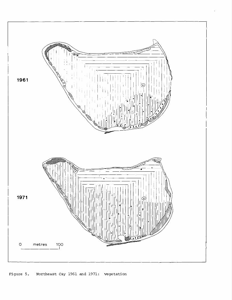
Northeast Cay 1961 and 1971: vegetat ion.
Long Cay North 1961 and 1971: topography.
Long Cay North 1961 and 1971: vegetat ion.
Long Cay 1961 and 1971: topography.
Long Cay 1961 and 1971: vegetat ion.
Middle Cay 1961 and 1971: topography.
Middle Cay 1961 and 1971: vegetat ion.
Southwest Cay I 1961 and 1971: topography.
Southwest Cay I 1961 and 1971: vegetat ion.
Southwest Cay I1 1961 and 1971: topography.
Southwest Cay I1 1961 and 1971: vegetat ion.
L i s t of P l a t e s
Nor theas t Cay: a e r i a l view from the e a s t 1962
Nor theas t Cay: s torm block and shore e r o s i o n on the e a s t s i d e 1961
Long Cay North: S u r i a n a scrub on t h e no r th shore 1961
Long Cay North: t h e south shore i n 1971
Long Cay from the s o u t h e a s t 1962
Southwest Cay I1 : a e r i a l view from t h e sou theas t 1962
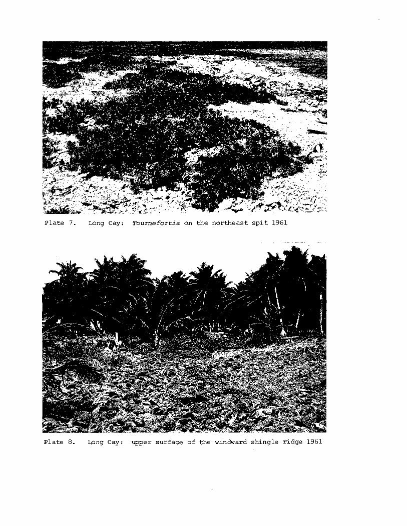
Long Cay: T o u r n e f o r t i a on the n o r t h e a s t s p i t 1961
Long Cay: upper s u r f a c e of t he windward sh ing le r i dge 1961
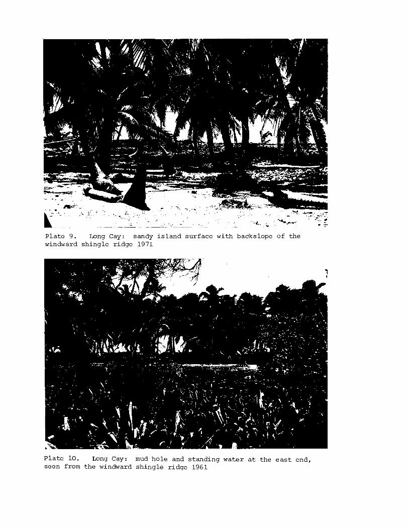
Long Cay: sandy i s l a n d su r f ace wi th backslope of t h e windward s h i n g l e r i dge 1971
Long Cay: mud h o l e and s t and ing wa te r a t t h e e a s t end , seen from t h e windward s h i n g l e r i dge 1961
Middle Cay: windward sh ing le r i dge wi th hedge o f T o u r n e f o r t i a 1971
Middle Cay: low lagoon shore wi th Conocarpus 1971
Middle Cay: Rhizophora a t t he e a s t end o f t h e lagoon shore 1971
Southwest Cay I: seaward rubble shore 1971
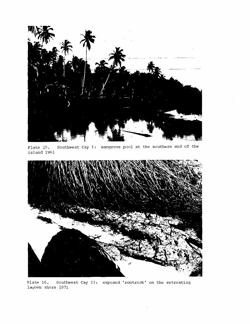
Southwest Cay I: mangrove pool a t t h e southern end of t h e i s l a n d 1961
Southwest Cay 11: exposed roo t rock ' on t h e r e t r e a t i n g lagoon shore 1971
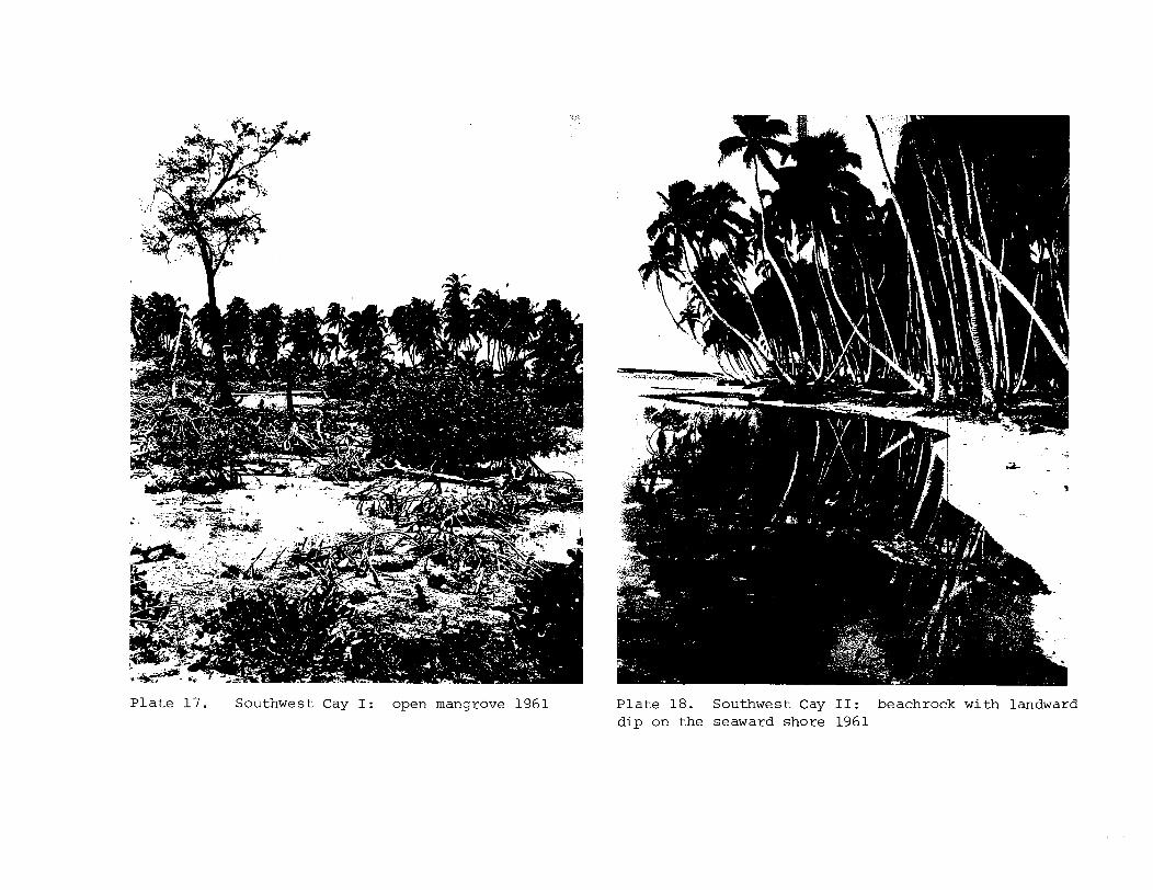
Southwest Cay I: open mangrove 1961
Southwest Cay 11: beachrock wi th landward d i p on t h e seaward shore 1961
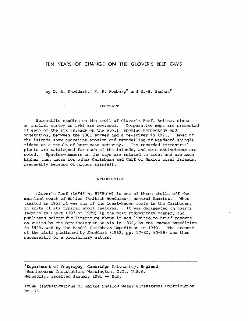
TEN YEARS OF CHANGE ON THE GLOVER'S REEF CAYS
by D. R. S toddar t , ' F. R. F'osberg2 and M..-H. sachet2
I ABSTRACT
S c i e n t i f i c s tud ies on the a t o l l of Glover's Reef, Belize, s ince an i n i t i a l survey i n 1961 are reviewed. Comparative maps are presented o f each of the s i x i s l a n d s on the a t o l l , showing morphology and vegetat ion, between the 1961 survey and a re-survey i n 1971. Most of the i s l ands show shorel ine erosion and remodelling of windward shingle r idges as a r e s u l t of hurricane a c t i v i t y . The recorded t e r r e s t r i a l p lan t s a re catalogued f o r each of the i s l ands , and some ex t inc t ions are noted. Species-numbers on the cays a r e r e l a t e d t o area , and a re much higher than those f o r o the r Caribbean and Gulf o f Mexico cora l i s l ands , presumably because of higher r a i n f a l l .
INTRODUCTION
Glover's Reef (16O45'NI 870501W) i s one of th ree a t o l l s o f f the mainland coas t o f Belize (Br i t i shHonduras) , c e n t r a l America. When v i s i t e d i n 1961 it was one of t h e least-known r e e f s i n the Caribbean, i n s p i t e of i t s t y p i c a l a t o l l fea tures . I t was del ineated on char t s (Admiralty Chart 1797 o f 1929) i n the most rudimentary manner, and published s c i e n t i f i c l i t e r a t u r e about it was l imi ted t o b r i e f r epor t s on v i s i t s by the o r n i t h o l o g i s t Salvin i n 1862, by the Pawnee Expedition i n 1925, and by the Mandel Caribbean Expedition i n 1940. The account of the a t o l l published by Stoddart (1962, pp. 17-30, 83-98) was thus necessar i ly of a preliminary nature.
' ~ e ~ a r t m e n t o f Geography, Cambridge University, England 2~mi thson ian I n s t i t u t i o n , Washington, D.C., U .S .A. Manuscript received January 1981 -- Eds.
IMSWE ( Inves t igat ions of Marine Shallow Water Ecosystems) Contribution No. 75
Since then, however, there has been a g rea t deal of s c i e n t i f i c invest igat ion on Glover' s Reef. The CITRE pro jec t (Comparative Investigations of Tropical Reef Ecosystems) included the a t o l l as one of i t s po t en t i a l study s i t e s , and reconnaissance v i s i t s were made t o it i n January and June 1971, followed i n November 1971 by a planning workshop for 40 s c i e n t i s t s held a t Long Cay (Smith, i n Sachet and Dahl (1974), l ists par t i c ipan ts ) . Descriptions of the reefs resu l t ing from CITRE s tudies were given by Dahl e t a1 . (1974, pp. 55-58) , and marine algae and sea-grasses col lected during the p ro jec t were reported by Tsuda and Dawes (1974). In 1972 N. James, R. N. Ginsburg and associa tes carr ied out s tudies of the deep reefs using the deep-diving submersible Nekton (James and Ginsburg 1980) . Final ly , reef s t ruc tures within the a t o l l lagoon have been studied by Hughes (1973) , Schafersman (1972) , Wallace (1974), and Wallace and Schafersman (1977). Apart from s tudies ca r r ied out during the C I T E workshop, t e r r e s t r i a l s tudies on the cays have been l imi ted t o p l an t col lect ions made by Pippen i n 1972 and by Linhart and students i n 1973 (Linhart 1980; Fosberg e t a1 . 1981) .
This paper reports on the re-survey of the cays ca r r ied out during the C I T E workshop i n 1971. Comparative maps of a l l the is lands i n 1961 and 1971 ark presented, together with complete l i s t s of t e r r e s t r i a l p lan t s recorded from each cay (including those reported by Linhart (1980)). A l l of the is lands were mapped by pace-and-compass methods. They were a lso photographed from the a i r i n colour and black-and-white i n 1961 and 1962, and more b r i e f l y i n 1971. The maps of each of the is lands are or ienta ted conventionally ( i . e . magnetic north a t the top of the diagram) .
HISTORY
The ear ly his tory of the a t o l l i s obscure, as indeed i s t ha t of most of the reefs i n the western Caribbean. I t can possibly be i den t i f i ed as the "Ilbob" o r "Ylbob" of maps by Herrera dated 1601-1615 and of De Laet i n 1625, and derivative char ts (Vindel 1955). I t appears as "Longorif" i n the Plano d e l a Cos ta de Honduras of 1756; as "Arrecife de Guaneros" i n a map by J. J. de Cas t i l l o , dated 1753 (reproduced by Craig 1966, p. 38) ; and as Glover's Reef by Speer (1771) and Arrecife Largo, Glover's Reef o r Long Reef by Jefferys (1775) . Speer's map marks three un-named cays; J e f f e ry s ' s map has f ive un-named cays i n the south and "The Two Spots" a t the northern end. The f i r s t Admiralty survey by Fdchard Owen i n 1830 adopts the name of Glover's Reef, which then became standard, and a l so fo r the f i r s t time names Northeast, Long, Middle, and Southwest Cays.
The only event of any significance i n the recorded h i s to ry of the a t o l l i s the wreck of the schooner Susan , Captain Harry Maury, which s a i l ed from Mobile on 4 December 1858 with emigrants and f i l i b u s t e r s bound f o r Omoa, Republic of Honduras, wrecked 10-12 miles from the cays on 16 December (Doubleday 1886 ; Scroggs 1916) . The vessel was found by a f ishing boat which had taken f i s h , green t u r t l e and coconuts t o the Belize market, and the passengers and crew were taken t o Middle Cay.

T a b l e 1. V i s i t o r s t o G l o v e r ' s Reef
D a t e
1858 December
1862 May
1925 A p r i l 14-20
1940 J a n u a r y 18
1969 March
1971 J a n u a r y 17-22
June 20-27
November 1-13
1972
1973 J u l y
V i s i t o r
Susan, Capt . Maury
Mary Ann, 0. S a l v i n
Pawnee, H. P. Bingham
Mandel Car ibbean E x p e d i t i o n
D. R. S t o d d a r t S. P. Murray
D. M. Devaney
J. Weber A. An ton ius
Work
O r n i t h o l o g y
Marine f auna
Marine m o l l u s c a R e p t i l e s
Geomorphology V e g e t a t i o n
Echinoderms
CITRE s t u d i e s
A. An ton ius , A. Dahl , K . R u e t z l e r
S . V. Smith and p a r t y o f 4 0
N. P. James, R. N. G insburg , Deep r e e f Nekton
Pippen
Y . B. L i n h a r t
F l o r a
F l o r a
P u b l i c a t i o n
Maury 1859
S a l v i n 1864; Coues 186.4
Boone 1927, 1928a-dl B r e d e r 1927
Haas 1941; Schmidt 1941
S t o d d a r t 1962
Devaney 1974
Dahl e t a1 1974 Tsuda and Dawes 1974
T h i s p a p e r
James and Ginsburg 1980
L i n h a r t 1980
This was s a i d t o be an i s l a n d of 30 acres (12 h a ) , with a "continuous grove of cocoa palms . . . [and] e n t i r e freedom from underbrush" (Doubleday 1886, p. 212) . Here they l i v e d on "conch' and green- tur t le soup, f i s h i n g r e a t v a r i e t y , cocoa-nuts, yams, p l a n t a i n s , and bread- f r u i t , a l l i n g r e a t abundance", u n t i l rescued by H.M.S. Bas i l i sk , s e n t from Bel ize , on Christmas Day 1858. There are b r i e f accounts of t h i s inc iden t i n Harper's Weekly, 8 January 1859, p. 22, and 15 January 1859, p. 39, and i n t h e Mobile Mercury a t the same time [not seen] , b u t the most c i rcumstant ia l account i s contained i n l e t t e r s by Captain Maury published i n The Mobile Daily Regis ter , vol . 32 (no. 1329) , p. 1 f o r 4 January 1859. We a re g r a t e f u l t o M r M. M. Weinstein, Library of Congress, f o r copies of these documents.
The p resen t study began with a v i s i t t o Glover's Reef by Stoddart and S. P. Murray i n 1961. This was a b r i e f reconnaissance supported by the Office of Naval Research and the Coastal S tudies I n s t i t u t e of Louisiana S t a t e University a s p a r t of a wider study of the B r i t i s h Honduras cays, and we a re g r a t e f u l t o the l a t e Professor Richard J. Russel l and Miss Evelyn P r u i t t f o r making it poss ib le . The second v i s i t took p lace a s p a r t of the CITRE workshop on 1-13 November 1971. The i s l a n d s were re-mapped and p l a n t s co l l ec ted by Stoddar t , Fosberg and Sachet, and we a re g r a t e f u l t o D r Stephen V. Smith, P r inc ipa l Inves t iga to r , f o r the opportunity t o p a r t i c i p a t e i n the CITRE planning sess ions . We a l s o thank M r M. Young and Mr R. Coe, of the Department of Geography a t Cambridge Universi ty, f o r much cartographic and photographic work, and M r M. M. Weinstein, Library of Congress, who obtained newspaper records r e l a t i n g t o the wreck of the Susan.
STRUCTURE AND FORM
The s t r u c t u r e of the e a s t coas t of the YucatanPeninsula i s contro l led by a s e r i e s of northeast-southwest t rending f a u l t blocks, arranged en echelon on the northwestern f lank of the Cayman Trench. One of these lineaments under l ies t h e Belize b a r r i e r reef south of Gladden S p i t , Glover's Reef, and Lighthouse Reef; another the c e n t r a l b a r r i e r r e e f , Turneffe, and Banco Chinchorro; and a t h i r d the mainland coas t north of Ambergris Cay. Of these , the f i r s t i s b e s t developed, and i n p laces ( a s on the e a s t s i d e of Lighthouse Reef) has a seaward- facing scarp nearly 3000 m high. A t Glover's Reef i t s e l f , the s e a f l o o r f a l l s sharply t o over 1000 m on the e a s t s ide of the a t o l l , bu t only t o shallow saddles of 300-400 m between the a t o l l and the b a r r i e r reef and the a t o l l and Lighthouse Reef. Wells d r i l l e d through the offshore r e e f s have reached metamorphic rocks probably equivalent i n age t o the mainland Santa Rosa Group (Carboniferous-Early Permian) a t between 777 and 959 m on Glover's Reef, and ext rus ive volcanics of s i m i l a r age a t 1692 m on Turneffe.
The su r f ace r e e f s , the re fo re , s tand on fault-block s t r u c t u r e s , a s o r i g i n a l l y i n f e r r e d from topography and f u l l y confirmed by seismic inves t iga t ions (Dil lon and Vedder 1972, 1973; Uchupi 1973) . The deep wel l on Glover's Reef showed 260 m of calcareous s i l t s t o n e of Late
Cretaceous age, ove r l a in by 560 m of T e r t i a r y reef f a c i e s ; s i m i l a r l y , on Turneffe, 660 m o f shale with limestone i s over la in by 1030 m of r ee f f a c i e s (Dillon and Vedder 1973, p. 2721) . These sequences i n d i c a t e reef upgrowth on subsiding f a u l t blocks a t r a t e s (1-2 cm/1000 y r ) and over time periods (ca 60 mi l l ion y r ) comparable t o those of upgrowth on open P a c i f i c subsiding volcanoes such a s Bikini and Enewetak.
Glover's Reef i t s e l f i s an elongate rec tangular a t o l l up t o 32 km long and 12 km wide, with an a rea of 260 sq km. I t i s surrounded by a shallow reef f l a t , genera l ly about 450-700 m wide b u t which reaches 1200 m on t h e eas te rn (windward) r e e f s . Living reef reaches the surface a t t h e ou te r edge of t h e reef f l a t f o r about 150 m on the windward reefs . There i s no a l g a l r idge d i r e c t l y comparable t o those of some Indo-Pacific a t o l l s , b u t r a t h e r an a l g a l pavement with rhodol i ths of Goniolithon boergesenii , c l e a r l y the funct ional equivalent of the a l g a l ridge. The leeward r e e f s a r e l e s s well-defined and lack the algal-pavement zone (Stoddart 1962, pp. 23, 25-26) . There a r e t h r e e gaps through t h e per iphera l r ee f s ; one i n the nor theas t , 1300 m wide; one i n the south, 1600 m i n width and up t o 12 m deep; and a smaller exposed channel a t the southeas t po in t .
The lagoon enclosed by the r e e f s has two components: a shallow she l f o r platform 6-8 m deep and genera l ly 1-2 km wide, and a c e n t r a l bas in . The platform i s s i m i l a r t o t h e " b a r r i e r platform" of t h e c o a s t a l s h e l f , and i s probably a reef surface of l a s t i n t e r g l a c i a l age on which the present surface r e e f s have grown. The c e n t r a l bas in i s probably about 20 m deep (no bathymetric survey has been undertaken), and contains some 700 patch reefs . Variat ion i n patch reef ecology and sedimentology has been s tudied by Schafersman (1972), Hughes (1973), Wallace (1974) , and Wallace and Schafersman (1977) .
The c o r a l fauna of Glover's Reef i s known only i n o u t l i n e . York's (1971) l ist of t h e c o r a l s of t h e southern Belize b a r r i e r lists 18 genera. W i t h t h e addi t ion of Mussa and Meandrina t h i s g ives 20 genera recorded from the Belize r e e f s (Stoddart 1962, p. 1 9 ) . 1 3 genera have been recorded from Glover's Reef ( i b i d ) , but unpublished CITRE records w i l l undoubtedly increase t h i s t o t a l . There a r e few o t h e r marine f a u n i s t i c records from Glover's Reef. Devaney (1974) records 3 a s t e r o i d s , 15 ophiuroids, one holothurian and 4 echinoids from c o l l e c t i o n s made i n 1969. Col lec t ions of crustaceans, molluscs, echinoderms, coelentera tes and f i s h e s made during the Pawnee Expedition a r e l i s t e d by Boone (1927, 1928a, 192813, 1928c) and Breder (1927). Tsuda and Dawes (1974) l i s t four sea-grasses and 100 species of marine algae from t h e CITRE inves t iga t ions . T e r r e s t r i a l records are l imi ted t o two r e p t i l e s (Anolis s a g r e i , Ctenosaura similis) co l l ec ted by the Mandel Caribbean Expedition i n 1940 (Schmidt 1941) and a hummingbird (Ancathothorax p revos t i ) l i s t e d by Todd (1942) .
There a r e no environmental records from Glover's Reef. The a t o l l i s under the inf luence of t h e Northeast Trades. There i s a marked ra iny season from June t o September, and mean annual r a i n f a l l is probably about 2500 mm. Mean t i d a l range a t spr ings i s probably about 0.2 m.

The a t o l l i s f r equen t ly a f f e c t e d by h u r r i c a n e s , and re fe rence t o t h e i r e f f e c t s w i l l be made i n t h e accounts of t h e cays.
There a r e s i x smal l i s l a n d s on t h e sou theas t e rn r ee f o f t h e a t o l l . The i r combined a r e a i s about 32 ha , and it i s wi th t h e changing morphology and vege t a t i on o f t h e s e cays t h a t t h i s paper i s concerned.
THE CAYS OF GLOVER'S REEF
There a r e a t p r e s e n t s i x cays on Glover 's Reef, a l l on t h e sou theas t s i d e . Five of t h e s e (Nor theas t , Long, Middle, Southwest I and Southwest 11) a r e s i z e a b l e i s l a n d s 360-600 m long; t h e s i x t h (Long Cay North o r Small Cay) i s an i s l e t 160 m long n o r t h e a s t o f Long Cay. I n a d d i t i o n t o t h e main i s l a n d s , J e f f e r y s i n h i s 1775 c h a r t marked "The Two Spots ' ' a t t h e nor th end of t h e a t o l l : t h e s e were presumably ephemeral sandbores and no longe r e x i s t . Admiralty Chart 1797 o f 1929 a l s o marks a f u r t h e r cay l y i n g wi th in t h e lagoon on t h e west s i d e o f t h e a t o l l , 7 km from t h e northwest co rne r ; it i s desc r ibed a s having t r e e s 6 m t a l l (West I n d i e s P i l o t , 1956, pp. 459-460). This i s l a n d d i d n o t e x i s t i n 1961, though an ephemeral sandbore nea r i t s l o c a t i o n was known a s "Bushy Spot" o r "Bushy Cay". Owen i n h i s 1830 c h a r t (Admiralty MS c h a r t H57) a l s o shows no cay a t t h i s l oca t ion . Owen i n 1830 a l s o noted two smal l sandbores between Middle Cay and Southwest Cays. Each of t h e e x i s t i n g i s l a n d s was mapped i n 1961 and 1971; they a r e desc r ibed from nor th t o south .
Northeast Cay (l6O45'N, 87O454'w) F igures 4-5, P l a t e s 1-2
Northeast Cay i s s i t u a t e d a t t h e south end o f t h e unbroken e a s t e r n r ee f o f Glover ' s Reef, on t h e nor th s i d e o f t h e en t r ance between it and Long Cay. I t i s semic i r cu l a r i n shape, wi th maximum dimensions of 360 x 200 m. I ts southern and southwestern sho re s , f ac ing t h e r ee f and t h e channel , a r e formed by a sh ing le r i dge w i th a maximum h e i g h t of about 2 m. I n 1961 t h e r e was evidence o f r e c e n t shore e r o s i o n on t h e e a s t s i d e o f t h e cay , i n d i c a t e d by shore c l i f f i n g , s u r f a c e sand s t r i p p i n g , and c o r a l b locks on t h e cay s u r f a c e ; by 1971 t h e s h i n g l e r i dge had extended northwards t o cover much of t h i s a r ea . A smal l a r e a of beachrock on t h e south shore i n 1961 had a l s o i nc reased i n l eng th t o about 90 m i n 1971, and a f u r t h e r smal l exposure had appeared, i n d i c a t i n g s l i g h t r e t r e a t o f t h i s sho re . The nor thern shore i s low and sandy, and was s t a b l e dur ing 1961-1971. The i n t e r i o r of t h e i s l a n d i s a l s o low and sandy, and t h e r e i s a smal l mudhole. The a r e a of t h e i s l a n d was 4.73 ha i n 1961 and 4.48 h a i n 1971. The i s l a n d i s covered wi th coconut woodland, which i s most dense and con ta in s t a l l t r e e s o f Bursera s imaruba, Neea c h o r i o p h y l l a and Thr inax r a d i a t a n e a r t h e south shore . There is a l u x u r i a n t undercarpet ' of W e d e l i a , Euphorbia, Ambrosia and g r a s s e s . The most ex t ens ive shrub on t h e seaward s i d e of t h e i s l a n d i s T o u r n e f o r t i a gnaphalodes with s c a t t e r e d Conocarpus , Coccoloba and Cord ia . There w e r e ex t ens ive mats o f Sesuvium along t h e lagoon shore . For f u r t h e r d e t a i l s of t h e i s l a n d i n 1961 see S todda r t (1962, pp. 87-88, f i g s . 38 and 39) .
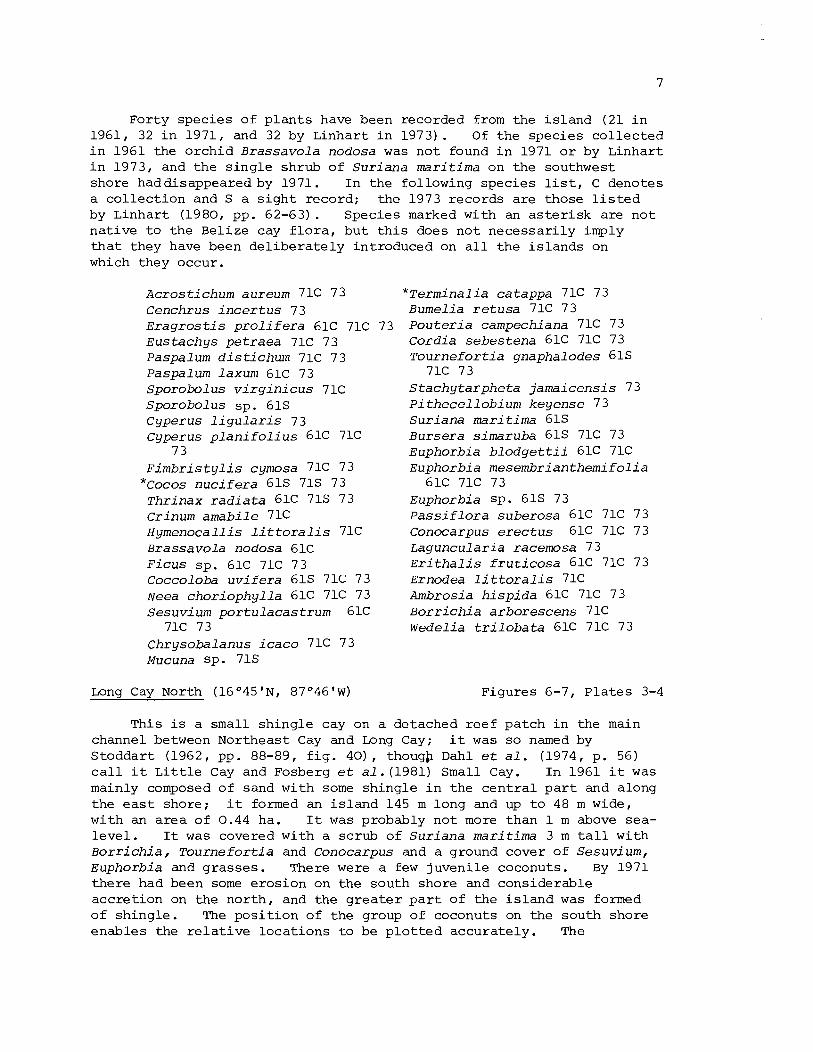
For ty s p e c i e s o f p l a n t s have been recorded from t h e i s l a n d (21 i n 1961, 32 i n 1971, and 32 by L i n h a r t i n 1973) . Of t h e s p e c i e s c o l l e c t e d i n 1961 t he o r c h i d B r a s s a v o l a nodosa was n o t found i n 1971 o r by L i n h a r t i n 1973, and t h e s i n g l e sh rub o f S u r i a n a m a r i t i m a on t h e southwest shore haddisappeared by 1971. I n t h e fo l l owing s p e c i e s l i s t , C denotes a c o l l e c t i o n and S a s i g h t r e co rd ; t h e 1973 r e c o r d s a r e t hose l i s t e d by L i n h a r t (1980, pp. 62-63) . Spec i e s marked w i t h an a s t e r i s k a r e n o t n a t i v e t o t h e B e l i z e cay f l o r a , b u t t h i s does n o t n e c e s s a r i l y imply t h a t t hey have been d e l i b e r a t e l y i n t roduced on a l l t h e i s l a n d s on which t hey occur .
A c r o s t i c h u m aureum 71C 73 * ~ e r m i n a l i a c a t a p p a 71C 73 Cenchrus i n c e r t u s 73 Bumel ia r e t u s a 71C 73 E r a g r o s t i s p r o l i f e r a 61C 71C 73 P o u t e r i a campechiana 71C 73 E u s t a c h y s p e t r a e a 71C 73 Paspalum d i s t i c h u m 71C 73 Paspalum l a x u m 61C 73 S p o r o b o l u s v i r g i n i c u s 71C S p o r o b o l u s sp . 61s Cyperus l i g u l a r i s 73 Cyperus p l a n i f o l i u s 61C 71C
7 3 F i m b r i s t y l i s cymosa 71C 73
" ~ o c o s n u c i f e r a 61s 71s 73 T h r i n a x r a d i a t a 61C 715 73 Crinum a m a b i l e 71C H y m e n o c a l l i s L i t t o r a l i s 71C BrassavoLa nodosa 61C F i c u s s p . 61C 71C 73 Coccoloba u v i f e r a 61s 71C 73 Neea c h o r i o p h y l l a 61C 71C 73 S e s u v i u m p o r t u l a c a s t r u m 61C
71C 73 Chrysoba lanus i c a c o 71C 73 Mucuna sp . 71s
Long Cay North (16O45'N, 8 7 O 4 6 ' ~ )
Cord ia s e b e s t e n a 61C 71C 73 T o u r n e f o r t i a gnapha lodes 61s
71C 73 S t a c h y t a r p h e t a j a m a i c e n s i s 73 P i thecell obi um k e y e n s e 7 3 S u r i a n a m a r i t i m a 61s Bursera s imaruba 61s 71C 73 Euphorbia b l o d g e t t i i 61C 71C Euphorbia m e s e m b r i a n t h e m i f o l i a
61C 71C 73 Euphorbia sp . 61s 73 P a s s i f l o r a s u b e r o s a 61C 71C 73 Conocarpus e r e c t u s 61C 71C 73 Laguncu lar ia racemosa 73 E r i t h a l i s f r u t i c o s a 61C 71C 73 Ernodea l i t t o r a l i s 71C Ambrosia h i s p i d a 61C 71C 73 B o r r i c h i a a r b o r e s c e n s 71C W e d e l i a t r i l o b a t a 61C 71C 73
F igu re s 6-7, P l a t e s 3-4
Th i s i s a s m a l l s h i n g l e cay on a de tached r e e f p a t c h i n t h e main channel between Nor theas t Cay and Long Cay; it w a s s o named by S t o d d a r t (1962, pp. 88-89, f i g . 40) , thougb Dahl e t a l . (1974, p. 56) c a l l it L i t t l e Cay and Fosberg e t a 1 . (1981) Small Cay. I n 1961 it w a s mainly composed o f sand w i t h some s h i n g l e i n t h e c e n t r a l p a r t and a long t h e e a s t shore ; it formed an i s l a n d 145 m l ong and up t o 48 m wide, w i t h an a r e a o f 0.44 ha. I t w a s p robab ly n o t more t h a n 1 m above sea- l e v e l . I t w a s covered w i t h a s c rub o f S u r i a n a m a r i t i m a 3 m t a l l w i t h ~ o r r i c h i a , Tourne f o r t i a and Conocarpus and a ground cover o f S e s u v i urn, Euphorbia and g r a s s e s . There were a few juven i l e coconuts . By 1971 t h e r e had been some e r o s i o n on t h e sou th sho re and cons ide r ab l e a c c r e t i o n on t h e n o r t h , and t h e g r e a t e r p a r t o f t h e i s l a n d w a s formed o f s h i n g l e . The p o s i t i o n o f t h e group o f coconuts on the sou th shore e n a b l e s t h e r e l a t i v e l o c a t i o n s t o be p l o t t e d a c c u r a t e l y . The

vegetat ion i s s t i l l dominated by S u r i a n a scrub, but Conocarpus and T o u r n e f o r t i a have g r e a t l y increased. There were severa l more juvenile coconuts. The length o f the i s l a n d remained a t 145 m, bu t the maximum width had increased t o 63 m and the a rea of 0.53 ha.
22 species of p l a n t s have been recorded from the i s l a n d (9 i n 1961, 16 i n 1971 and 19 by Linhart i n 1973). Sophora t o m e n t o s a , which e x i s t e d a s a s ing le p l a n t on the south shore i n 1961, had disappeared by 1971. The species recorded a re :
Paspalurn d i s t i churn 71C 73 S p o r o b o l u s v i r g i n i c u s 71C 73 Cyperus l i g u l a r i s 73 Cyperus p l a n i f o l i u s 71C 73 Cyperus sp . 61s
*Cocos n u c i f e r a 61s 71s 73 Crinum amab i l e 71C Hippeas t rum puniceum 73 H y m n o c a l l i s l i t t o r a l i s 73
*Casuar ina e q u i s e t i f o l i a 71s 73 Coccoloba u v i f e r a 73 B a t i s mar i t ima 73
P h i l o x e r u s vermi c u l a r i s 71C S e s u v i u m p o r t u l a c a s t r u m 6 1 S 7lC 73 Sophora tomn t o s a 6 1s S u r i a n a m a r i t i m a 61s 71C 73 Euphorbia b l o d g e t t i i 71C Euphorbia m s e m b r i a n themi f o l i a
71C 73 Euphorbia sp. 61s 73 Conocarpus e r e c t u s 61s 71C 73 I p o m e a macrantha 71C 73 I p o m e a pes-caprae 71C 73 T o u r n e f o r t i a gnaphalodes 61s 71C 73 B o r r i c h i a a r b o r e s c e n s 61s 71C 73
Long Cay (16045'N1 87O46'W) Figures 8-9, P l a t e s 5 , 7, 8, 9 and 10
Long Cay i s s i t u a t e d a t the nor theas tern extremity of the continuous southeast reef of the a t o l l . ,When f i r s t mapped i n 1961 it was 620 m long and var ied i n width from 70 m i n t h e cent re t o 150 m a t each end; i t s eas te rn end was prolonged lagoonward by a low sandy peninsula. The a rea of the cay was 6.69 ha. The seaward s i d e of the i s l a n d was formed by a massive double shingle r idge . The ou te r r idge reached up t o 2 m above sea l e v e l and the inner r idge 3 m; the sh ingle complex was 30-40 m along the whole seaward shore. The inner r idge was formed of o lde r and coarser ma te r i a l , with blocks up t o 0.6 m i n diameter. There was an abrupt junction between the inner margin of the sh ingle and the low-lying sandy surface of the r e s t of the cay, e spec ia l ly a t the eas te rn end where the re was a depression with standing water. The nor th shore i s low and sandy and faces a shallow bay carpeted with sea-grasses. The morphology of the cay had changed q u i t e considerably by 1971. The seaward shingle ridge had been reworked, e spec ia l ly a t i t s western end where it had been pushed back over the sand surface and had become a t r i p l e r idge. Ret rea t o f a few metres had occurred along much of the seaward shore, increas ing the length of a beachrock r idge exposed from 180 t o 360 m. The g r e a t e s t change, however, had taken p lace a t the eas te rn end of the cay, where the shore l ine had r e t r e a t e d from 15 t o 25 m along i t s e n t i r e length. The nor theas tern peninsula had a l s o narrowed and moved westwards. A s a r e s u l t the t o t a l length of the i s l a n d had decreased t o 600 m, and the width now var ied from 65-130 m; t he area i n 1971 was 5.85 ha.
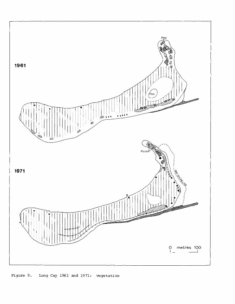
In 1961 Long Cay was covered w i t h a coconut plantation. The is land was inhabited, and the ground beneath the coconuts was kept cleared. Most of the seaward shingle ridges were bare, except f o r scat tered T o u r n e f o r t i a and Coccoloba, and an extensive area a t the eastern end of H y m n o c a l l i s with Conocarpus. The northeastern peninsula was covered with a low scrub of S u r i a n a , Conocarpus, T o u r n e f o r t i a and Laguncular ia , and indeed resembled Long Cay North. The general aspect of the cay was much the same i n 1971. The extensive ridge-crest area of H y m n o c a l l i s remained,. but a l l the Coccoloba and T o u r n e f o r t i a of the seaward coast had disappeared. The northeastern peninsula was covered with T o u r n e f o r t i a , Laguncu lar ia , Conocarpus and S e s u v i urn.
In 1971 the mudhole area was found t o be pa r t l y surrounded by a surface outcrop of phosphate rock, previously overlooked. This has a P205 content of 21.7% (Scoffin and Stoddart, i n prep.) . Long Cay is no longer a b i r d is land. Salvin, who v i s i t e d it on 1 2 May 1862, found a few terns and some pelicans (Salvin 1864, p. 384; Coues 1864) . The date of formation of the phosphate rock i s not known. The physiographic changes between 1961 and 1971 must be a t t r ibu ted t o hurricanes. Possibly much of the coasta l change resul ted from Hurricane Hatt ie i n 1961. Antonius (1972) was on Long Cay a t the time of Hurricane Laura on 20 November 1971. This had winds of 35 m/sec, f o r a time reaching more than 50 m/sec, but although some coconut palms were f e l l e d the e f f ec t s were negligible. Long Cay was occupied by a local family i n 1961 t o look a f t e r the plantation. By 1971 an American-owned t o u r i s t resor t had opened on the cay, with a s e r i e s of holiday chalets a t the e a s t end. These were damaged i n Hurricane Laura.
28 p lan t species have been recorded from the cay (10 i n 1961, 2 1 i n 1971, and 22 by Linhart i n 1973) ; i n addition there are some col lect ions made by Pippen i n 1972. One species found i n 1961 (Sophora t o m n t o s a ) has not been seen since. In addit ion t o the species l i s t e d below, the sea-grasses Thal a s s i a t e s t u d i n u m and S y r i n g o d i urn f i l i f o r m e occur i n shallow water on the lagoonward s ide of the cay. In the following l i s t species marked 72 were collected by Pippen in t h a t year. For fu r ther notes on t h i s is land, see Stoddart (1962, pp. 89-91, f igs . 41, 42 and 44) .
Psiloturn nudurn 72 Acrost ichum aureum 7 3 S p a r t i n a p a t e n s 71C Sporobol u s v i r g i n i c u s 71C 72
7 3 Cyperus l i g u l a r i s 73 Cyperus p l a n i f o l i u s 71C 72 Cyperus sp. 61s F i m b r i s t y l i s cymosa 71C 72 73
* ~ o c o s n u c i f e r a 61s 71s 73 T h r i n a x r a d i a t a 71C 73 Hymenocal l i s l i t t o r a l i s 61s
71C 73
F i c u s sp. 73 Coccoloba u v i f e r a 61s 71C 73 Sesuvium por tu lacas t rum 71C 73 Mucuna sp. 71C Sophora tomen t o s a 6 1s Sur iana mari t ima 61s 71C 73 Euphorbia b l o d g e t t i i 73 Euphorbia mesembr ian themi fo l ia
71C 73 Euphorbia sp. 61s 73 Rhizophora mangle 73 Conocarpus e r e c t u s 61s 71C 72 73 Burnelia r e t u s a 71C 72 73

Cordia s e b e s t e n a 71C 73 Ageratum l i t t o r a l e 61C 71C 73 T o u r n e f o r t i a gnaphalodes 61s Ageratum (abnormal) l i t t o r a l e
71C 73 71C E r i t h a l i s f r u t i c o s a 71C 73 B o r r i c h i a arborescens 71C 72 73
Melanthera n i v e a 71C
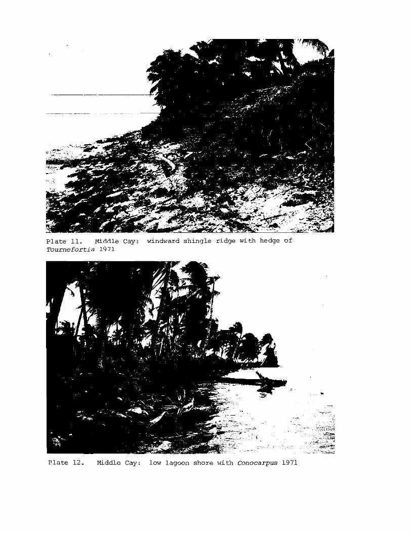
Middle Cay (16044'NI 87O48'W) Figures 10-11, P l a t e s '11-13
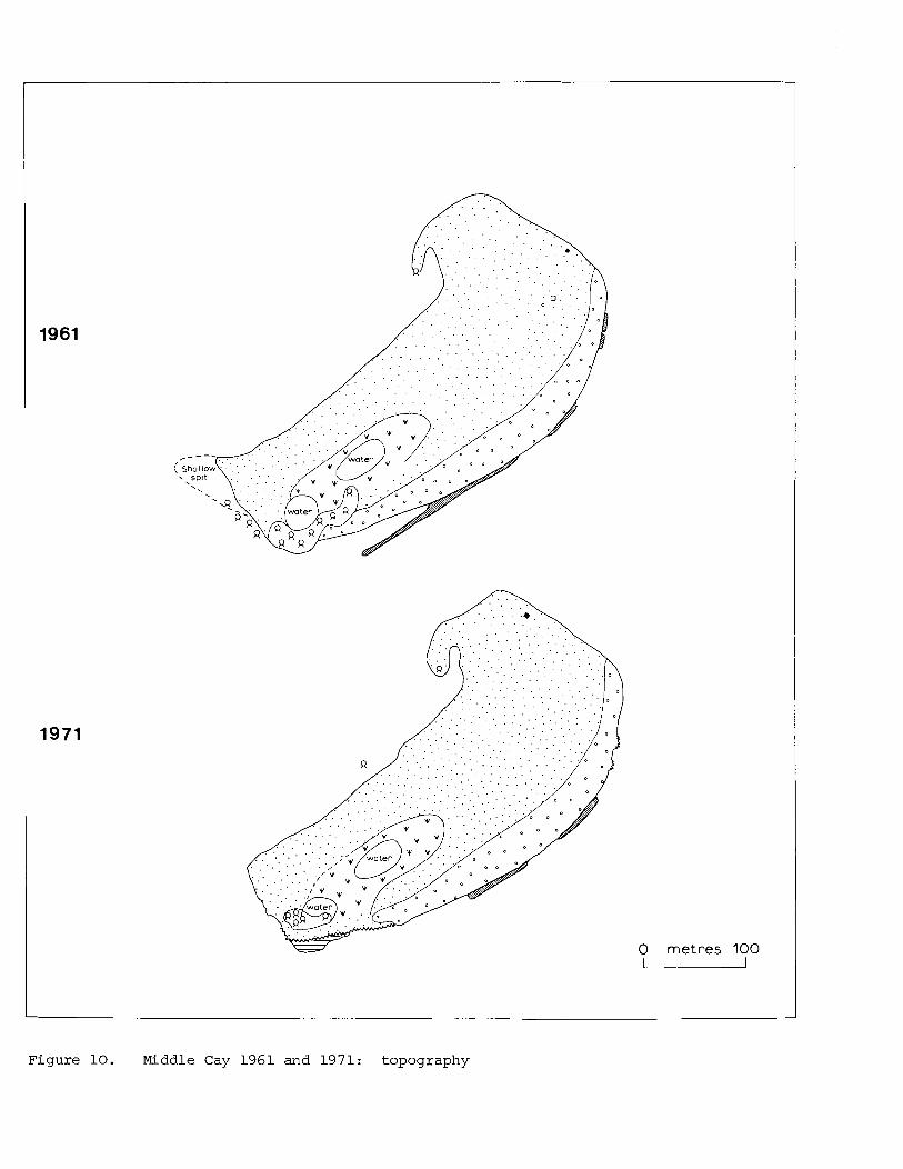
Middle Cay i s loca ted near the cen t r e o f t he unbroken sou theas t reef of Glover 's Reef. I t i s a l igned northeast-southwest , p a r a l l e l t o the t r e n d of the r ee f . When mapped i n 1961 it was about 415 m long and up t o 175 m wide, with an area of 6.03 ha. In 1971 e ros ion a t t he southwest p o i n t had been counterbalanced by aggradat ion a t the n o r t h e a s t s p i t , and the o v e r a l l dimensions and area (5.97 ha) remained t h e same. The seaward shore i s formed by a sh ing le r idge up t o 35 m wide and 2 m high; beachrock outcrops a t the f o o t of t h i s r idge , more ex tens ive ly i n 1961 than i n 1971. Most of the r e s t of the cay is low-lying and sandy, with a low leeward sand beach, b u t a t t he southwestern end the re is an extens ive swamp a r e a with s tanding water about 170 m long and 45 m wide. I n 1961 t h i s was separa ted from the s e a by a b e l t of t a l l Rhizophora, b u t by 1971 t h i s had been g r e a t l y reduced and the shore showed s i g n s of e ros ion . The sand s p i t a t t he no r theas t end of the cay had expanded lagoonward during t h i s i n t e r v a l and increased i n s i z e .
Most of the i s l a n d i s covered with coconut woodland. In 1961 the seaward sh ing le was - l a rge ly ba re , except f o r ex tens ive Hymenocal l i s and T o u r n e f o r t i a a t the e a s t e r n end. This had almost completely disappeared by 1971, b u t T o u r n e f o r t i a had colonised a f r e s h along most of t he seaward shore. There had a l s o been much growth of Laguncular ia , Conocarpus , Rhizophora and B o r r i c h i a along the lagoon shore and on the n o r t h e a s t s p i t . There i s a l u x u r i a n t ground cover beneath the coconuts. These were the dominant vegeta t ion a s e a r l y a s 1858 when Maury found a "continuous grove of cocoa palms" and " e n t i r e freedom from underbush" (Doubleday 1886, p. 212). That the swampy a r e a was a l s o then i n ex is tence i s shown by S a l v i n ' s record of Acros t i chum aureum i n May 1862 (Salvin 1864).
42 p l a n t spec ie s have been recorded from the cay (11 i n 1961, 40 i n 1971, and 32 by Linhar t i n 1973). H i b i s c u s t i l i a c e u s , c o l l e c t e d i n 1961, has n o t been seen s ince . P l a n t s recorded a r e :
Acrost ichum aureum 18628 71C 73
Andropogon glomeratus 71C 73 Cenchrus i n c e r t u s 71C E r a g r o s t i s p r o l i f e r a 71C 73 Eus tachys pe t raea 71C 73 Paspalum d i s t i c h u m 71C 73 Paspalum laxum 71C Sporobol u s v i r g i n i c u s 71C Cyperus l i g u l a r i s 71C 73 Cyperus p l a n i f o l i u s 71C 73 F i m b r i s t y l i s cymosa 61C 71C 73
*Cocos n u c i f e r a 61s 71s 73 T h r i n a x r a d i a t a 71C Hymenocal l i s l i t t o r a l i s 61s
71C 73 F i c u s sp . 71C 73 Coccoloba u v i f e r a 71C 73 Neea chorioph y l l a 71C S e s u v i um p o r t u l acastrum 71C P i t h e c e l l o b i u m k e y e n s e 71C 73 Sophora tomentosa 71C 73 Sur iana mari t ima 71C 73 Euphorbia b l o d g e t t i i 71C
Euphorbi a mesembri an themi f o l i a 71C 73
Euphorbia sp. 61s 73 H i b i s c u s t i l i a c e u s 61C P a s s i f l o r a s u b e r o s a 71C 73 Rhizophora mangle 61s 71C 73 Conocarpus e r e c t u s 61s 71C 73 Laguncu lar ia racemosa 71C 73
* T e r m i n a l i a ca tappa 71C Bumel ia r e t u s a 71C 73 P o u t e r i a campechiana 71C 73 Cord ia s e b e s t e n a 71C 73
There i s i n add i t i on the casua l record
T o u r n e f o r t i a gnaphalodes 61s 71C 73
S t a c h y t a r p h e t a j a m a i c e n s i s 61s 71C 73
Diodia s e r r u l a t a 71C E r i t h a l i s f r u t i c o s a 71C 73 Ernodea l i t t o r a l i s 71C 73 Ageratum li t t o r a l e 71C Agera t um mari t imum 7 3 Ambrosia h i s p i d a 61s 71C 73 B o r r i c h i a a r b o r e s c e n s 61s 71C 73 W e d e l i a t r i l o b a t a 71C 73
in 1858, a lready mentioned, of Dioscorea sp. , Musa sp., and A r t o c a r p u s a l t i l i s (Doubleday 1886, ?. 212).
For f u r t h e r d e t a i l s o f Middle Cay, s ee S todda r t (1962, pp. 92-93; f i g s . 43-45) . Southwest Cay I (16O42'N, 87O495'W) Figures 12-13, P l a t e s 14 , 15 and 17
Southwest Cays a re l oca t ed a t t he southwest ex t remi ty o f t h e southeas t r ee f o f t h e a t o l l , immediately e a s t o f t h e broad southern sn t rance t o t h e lagoon. Southwest Cay I i s the e a s t e r l y of t he two. I t i s a t r a p e z o i d a l i s l a n d with maximum dimensions i n 1961 of 360 x 270 m. The seaward shore i s formed by a low c a r p e t o f rubble and sh ingle r a t h e r than by a d i s t i n c t sh ing le r i dge , a s on t h e o t h e r cays, though the re was a s e c t o r o f sh ing le r idge up t o 2 m high a t t h e southern po in t of t h e cay. This seaward rubble zone i s backed by a zone o f swamp and s t and ing water measuring some 230 x 130 m a t t h e e a s t e r n end ~f the i s l a n d , with a second smal le r zone a t t h e western end. Only i n the l e e o f t he sh ing le r idge i s the land su r f ace continuous t o t he l e e shore . The lagoon shore i s low, sandy, and i n 1961 was undercut , with a number o f f a l l e n coconuts. By 1971 t h e r e were only minor physiographic changes. There was some rearrangement of rubble on the seaward s i d e , and t h e seaward sh ingle r idge was much sma l l e r and eroded. The gross dimensions of t he i s l a n d remained t h e same, and the a r e a was only s l i g h t l y sma l l e r (8.70 ha compared with 9.02 ha) .
The vege ta t ion of t he i s l a n d c o n s i s t s o f coconut woodland and mangroves. The western shore has a s t and o f t a l l Rhizophora c l o s i n g the en t rance t o t he western marsh. Rhizophora was a l s o found a t t h e e a s t e r n marsh en t rance , t oge the r with A v i c e n n i a , and t h e r e was a l a r g e clump o f A v i c e n n i a on t h e seaward shore. The l a r g e r marsh was f r inged with Conocarpus and o t h e r shrubs, and many coconuts had r e c e n t l y been 1 ,
IPlanted i n it. Changes by 1971 were r e l a t i v e l y minor. Much o f t h e mangrove a t t h e en t rance t o t h e l a r g e r marsh had disappeared, a s had {most of t h e ~ v i c e n n i a on t h e seaward shore. There had, however, been ' ex tens ive co lon i sa t ion o f t h e sh ingle r idge by Cord ia a t t h e south k o i n t .
40 species of p l a n t s are recorded from the cay, and t h i s t o t a l doubtless r e f l e c t s the d i v e r s i t y of h a b i t a t on the i s l and . 16 were recorded i n 1961, 24 i n 1971 and 34 by Linhart i n 1973. Of the species recorded i n 1961 only Euphorbia t r i c h o t o m a has not been seen s ince , but t h i s suggests oversight r a the r than ext inct ion. In p a r t i c u l a r the i s l a n d was l e s s thoroughly col lec ted , except f o r the west end, than the o t h e r Glover's Reef cays. Species i n the following l ist marked 72 were col lec ted by Pippen i n 1972. In the following l is t Ageratum marit imum must be considered a dubious record, probably a mis ident i f ica t ion of A. l i t t o r a l e .
Andropogon g lomera tus 7 3 Cenchrus i n c e r t u s 71C 73 E r a g r o s t i s p r o l i f e r a 71C 73 Eus tachys p e t r a e a 71C 73 Paspalum d i s t i c h u m 71C 73 Paspalum laxum 73 S p a r t i n a p a t e n s 71C Sporobo l u s sp . 61s Cyperus l i g u l a r i s 73 Cyperus p l a n i f o l i u s 73 Cyperus sp. 61s F i m b r i s t y l i s cymosa 73 F i m b r i s t y l i s sp. 61s
"COCOS n u c i f e r a 61s 715 73 Hymenocal l i s l i t t o r a l i s 71s 73 Myrica c e r i f e r a 73 Coccoloba u v i f e r a 61s 71s 73 B a t i s mar i t ima 71C 73 Iresine d i f f u s a 61C 72 73 P h i l o x e r u s v e r m i c u l a r i s 7 3 Por tu laca o l e r a c e a 71s Sesuv ium p o r t u l a c a s t r u m 61s 73 S u r i a n a mar i t ima 61s 715 73
Euphorbia b l o d g e t t i i 72 Euphorbia m e s e m b r i a n t h e m i f o l i a
7 3 Euphorbia t r i c h o t o m a 61C Euphorbia sp. 61s 73 P a s s i f l o r a suberosa 71C 73 Rhizophora mangle 61s 71s 73 Conocarpus e r e c t u s 61s 71s 73 Laguncul a r i a racemosa 7 1 C Rhabdadenia bi f l o r a 7 3 Ipomoea pes-caprae 61s 73 Cordia s e b e s t e n a 61s 71C 73 T o u r n e f o r t i a gnaphalodes 61s
71C 73 Avicenn ia germinans 61s 71C 73 S t a c h y t a r p h e t a j d m a i c e n s i s
71C 73 Caprar ia b i f l o r a 71C 73 E r i t h a l i s f r u t i c o s a 71C 73 Ageratum l i t t o r a l e 71C Ageratum mari t imum 73 B o r r i c h i a a r b o r e s c e n s 71C 73 E c l i p t a a l b a 73 Wede l ia t r i l o b a t a 715 73
For f u r t h e r notes on t h i s i s l and , see Stoddart (1962, pp. 93-95, f igs . 46-47).
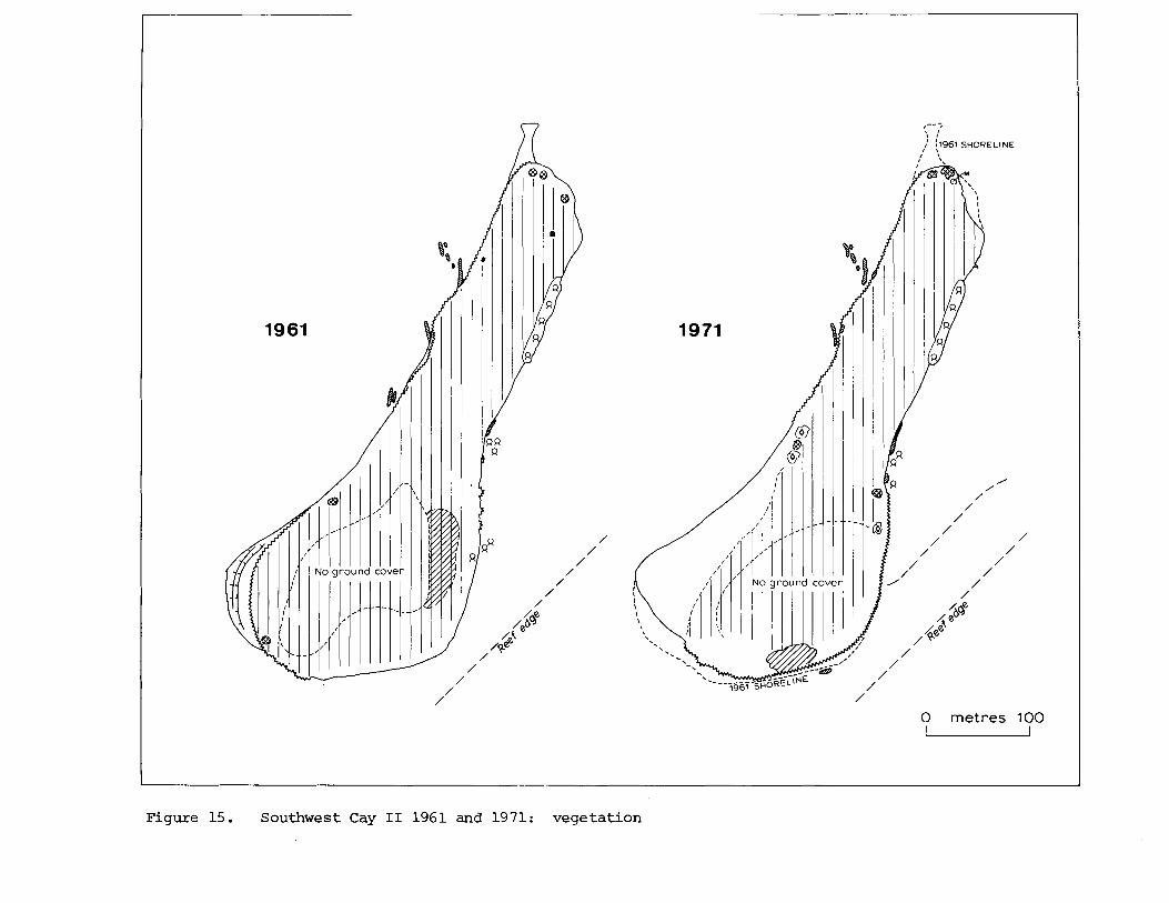
Southwest Cay I1 (16°41$ '~ , 87'50'W) Figures 14-15, P la tes 6 , 16 and 18
Southwest Cay I1 i s the most southerly i s l a n d on Glover's Reef. Although immediately adjacent t o Southwest Cay I it i s of very d i f f e r e n t character . I t is al igned a t an angle of 45O t o the reef edge, and shingle i s only found along the southern shore close t o the reef . The r e s t of the i s l and is sandy, and the re i s no i n t e r i o r depression o r mangrove swamp. When mapped i n 1961 the i s l a n d was 560 m long and had a maximum width of 235 m; i t s area was 6.66 ha. The narrow southern shingle r idge reached about 1.5 m above sea l eve l . Much of the eas tern shore was low and sandy, with many Rhizophora seedl ings , i n s p i t e of being on the seaward s ide of the i s l and ; it faced a broad
shallow reef f l a t connecting with Southwest Cay I. The western shore i s a l s o sandy, bu t narrow and undercut: i n i t s nor the rnpar t it was l ined with coconut boles and f a l l e n trunks. There were severa l exposures of r e l i c t beachrock on t h i s western shore, ind ica t ing both beach r e t r e a t and re-alignment as the shore l ine moved i n a clockwise d i rec t ion . There was f u r t h e r evidence of shore erosion a t the southwest po in t , though masked i n 1961 by a f resh sandspi t . Beach r e t r e a t was likewise evident on the e a s t shore, a s shown by undercut coconuts and small patches of beachrock which unusually showed landward dip. Physiographic changes had been minor by 1971. There had been erosion round t h e southern p a r t of the cay, and the southern shingle r idge was more extensive; there had a l s o been eros ion a t the northern end. A s a r e s u l t the o v e r a l l length of the cay had decreased t o 540 m and the area t o 6.23 ha. The previous beachrock outcrops were s t i l l v i s i b l e , together with another on the south shore.
The i s l a n d i s e n t i r e l y covered with coconut woodland. Except i n the southern p a r t t h i s has an undergrowth of herbs and grasses. Apart fr.om occasional Conocarpus and S u r i a n a bushes the only coas ta l vegetat ion i s a narrow b e l t of Rhizophora on p a r t of the e a s t shore. 40 species of p l a n t s are recorded from the i s l and (12 i n 1961, 37 i n 1971, and 31 by Linhart i n 1973), a r e f l e c t i o n of the d i v e r s i t y of the ground cover under the coconut woodland. They are :
Andropogon g l o m e r a t u s 61s 71C Cenchrus i n c e r t u s 71C 73 E r a g r o s t i s p r o l i £era 71C E u s t a c h y s p e t r a e a 71C 73 Paspal um d i s t i chum 71C Paspalum l a x u m 71C S p a r t i n a p a t e n s 71C S p a r t i n a s p a r t i n a e 73 Sporobo l u s vi r g i n i c u s 71C 7 3 S p o r o b o l u s sp. 61s C y p e r u s l i g u l a r i s 73 Cyperus p l a n i f o l i u s 71C 73 F i m b r i s t y l i s cymosa 71C 73
*Cocos n u c i £era 61s 71s 7 3 Hymenoca l l i s l i t t o r a l i s 6 1 S 71C Coccoloba u v i £era 71C B a t i s m a r i t i m a 73 Iresine d i f f u s a 71C '7 3 R i v i n a h u m i l i s 71C 73 P o r t u l a c a o l e r a c e a 71C 73 S e s u v i u m p o r t u l a c a s t r u m
61s 71C 73 C a k i l e l a n c e o l a t a 61s 71C
Canava l ia r o s e a 71C 73 S u r i i m a m a r i t i m a 71C 73 Euphorb ia b l o d g e t t i i 61C 71C Euphorbia mesembri an t h e m i f o l i a
71C 73 Euphorbia sp. 61s 73 P a s s i f l o r a s u b e r o s a 71C 73 Rhi zophora mangle 61s 71C 73 Conocarpus e r e c t u s 61s 71C 73 T e r m i n a l i a ca tappa 71C Ipomoea macrantha 71C 73 Ipomoea pes-caprae 71C 73 Ipomoea s t o l o n i f e r a 71C 73 Ipomoea sp. 61s
73 T o u r n e f o r t i a gnapha lodes 71C 73 S t a c h y t a r p h e t a j a m a i c e n s i s
61C 71C 73 C a p r a r i a b i f l o r a 71C 73 E r i t h a l i s f r u t i c o s a 71C 73 Ernodea l i t t o r a l i s 71C 73 Morinda c i t r i f o l i a 71C Ageratum l i t t o r a l e 71C 73 W e d e l i a t r i l o b a t a 71C 73
Salvin v i s i t e d t h i s i s l a n d on 12 May 1862. H e found "noddies everywhere . . . many thousands i n a l l " , and speculated "what must the numbers have been when the Sooty Terns flocked t o the same is landt ' (Salvin 1864, p. 383). Coues (1864) l i s t e d Anous s t o l i d u s (on coconuts)
and Anous t e n u i r o s t r i s (on mangroves) . The brown noddies s t i l l inhabi t the cay but i n small numbers; there are no records of Sooty Terns breeding there. For fu r ther d e t a i l s , see Stoddart (1962, pp. 95-98, f ig . 48).
SUMMARY AND CONCLUS IONS
These surveys have established the va r i ab i l i t y of reef i s lands even over so shor t a period as a decade. A l l of the l a rger i s lands have decreased i n area (Table 2 ) , with the possible exception of Middle Cay, and these changes have been mainly effected by erosion and remodelling of windward coasts during major storms. Change has been most severe a t the eas tern end of Long Cay, but can be traced on a l l the is lands i n changed shore morphology, d i s t r ibu t ion of windward shingle r idges, and exposure of beachrock. Leeward o r lagoon shores, on the other hand, have been more s t ab l e , and i n some cases leeward sand s p i t s have increased i n area (Long Cay, Middle Cay) . The i s l e t of Long Cay North is the only one t o have increased markedly i n s i z e , bu t it i s so small t h a t the change could readi ly be reversed.
Our data do not allow inferences about colonisation of the cays by new p lan t species between the surveys, nor do we wish t o discuss the f l o r i s t i c biogeography of the i s lands i n t h i s paper. We can, however, record the following loca l extinctions : B r a s s a v o l a nodosa and S u r i a n a m a r i t i m a on Northeast Cay; H i b i s c u s t i l i a c e u s on Middle Cay; and Sophora tomen tosa on Long Cay and Long Cay North. A l l were represented i n 1961 by s ingle specimens. B r a s s a v o l a i s an uncommon epiphyte; the H i b i s c u s was a s ingle lagoon-shore t r e e ; Sophora i s a beach legume l i a b l e t o subst ra te disturbance. This l a s t e f f ec t i s a l so seen i n the widespread disappearance of T o u r n e f o r t i a and Coccoloba on the windward shingle ridges of Long Cay between 1961 and 1971, as a r e s u l t of topographic change; they did not become local ly ex t i nc t only because they exis ted i n other hab i ta t s on the cay.
The t o t a l recorded t e r r e s t r i a l f l o r a of Glover's Reef now stands a t 70 species. Of these, 30pe rcen t ( 2 1 species) occur on only one i s land . Taking the species recorded from a l l the Belizean a t o l l s (Lighthouse Reef, Turnef f e , Glover's Reef) , 28 species o r 40 per cent of the Glover's Reef f l o r a are recorded only from t h a t a t o l l : t h i s undoubtedly r e f l ec t s the s t a t e of col lect ing on the other a t o l l s ra ther than any loca l pecu l ia r i ty on Glover's Reef. There i s a simple re la t ionship between number of p lan t species and area of the cays, though the anomalously low figure of species fo r Long Cay ind ica tes the e f f e c t of coconut planting and c lear ing on t h a t i s land. The species d ivers i ty f igures fo r the Glover's Reef cays are markedly higher (by a fac tor of two) than those of o ther Caribbean and Gulf of Mexico reef i s l and groups, such as the Dry Tortugas, Alacran, the Pedro Cays, and the Morant Cays. This probably r e su l t s from the much wet ter environment of Glover' s Reef ra ther than from d i f fe r ing proximity of i s l ands t o source areas. The f l o r i s t i c biogeography of western At lant ic reef i s lands w i l l form a separate paper; t h a t of the Belize cays i n general has been examined by Stoddart and Fosberg ( i n p r e s s ) .
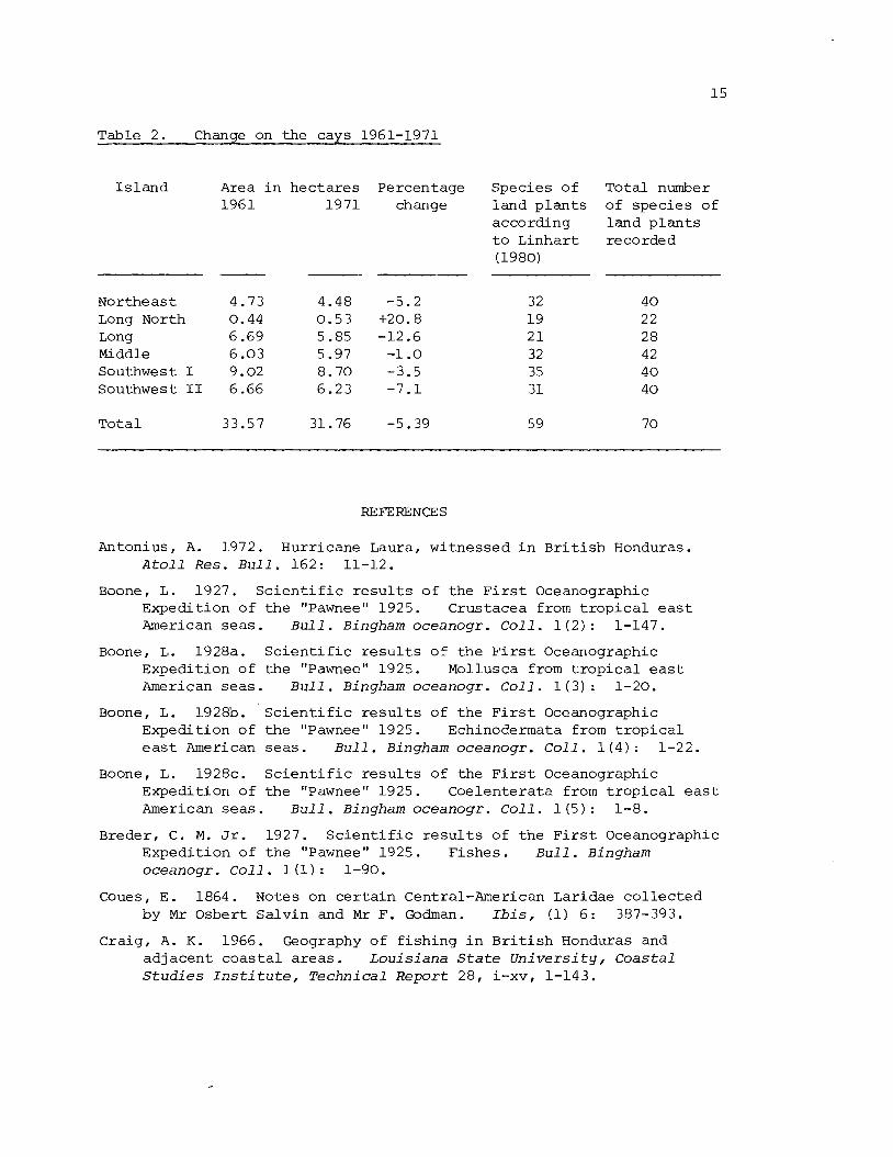
Table 2. Chanse on t h e cavs 1961-1971
I s l a n d Area i n h e c t a r e s Percentage 1961 1971 change
Nor theas t 4.73 Long North 0.44 Long 6 -69 Middle 6 .03 Southwest I 9.02 Southwest I1 6.66
T o t a l 33.57
Spec ies o f l and p l a n t s according t o L inha r t (1980)
To ta l number of spec i e s o f l and p l a n t s recorded
REFERENCES
Antonius, A. 1972. Hurr icane Laura, wi tnessed i n B r i t i s h Honduras. A t o l l R e s . B u l l . 162: 11-12.
Boone, L. 1927. S c i e n t i f i c r e s u l t s o f t h e F i r s t Oceanographic Expedi t ion o f t h e "Pawnee" 1925. Crustacea from t r o p i c a l e a s t American s e a s . B u l l . Bingham o c e a n o g r . C o l l . l ( 2 ) : 1-147.
Boone, L. 1928a. S c i e n t i f i c r e s u l t s o f t h e F i r s t Oceanographic Expedi t ion of t h e "Pawnee" 1925. Mollusca f r o m t r o p i c a l e a s t American s e a s . B u l l . Bingham o c e a n o g r . C o l l . l ( 3 ) : 1-20.
Boone, L. 1928b. S c i e n t i f i c r e s u l t s o f t h e F i r s t Oceanographic Expedi t ion of t h e "Pawnee" 1925. Echinodermata from t r o p i c a l e a s t American s e a s . B u l l . Bingham oceanoqr . C o l l . 1 (4 ) : 1-22.
Boone, L. 1928c. S c i e n t i f i c r e s u l t s o f t h e F i r s t Oceanographic Expedi t ion o f t h e "Pawnee" 1925. Coelen te ra ta from t r o p i c a l e a s t American s e a s . B u l l . B i n g h a m o c e a n o g r . C o l l . l ( 5 ) : 1-8.
Breder, C. M. Jr. 1927. S c i e n t i f i c r e s u l t s o f t h e F i r s t Oceanographic Expedi t ion o f t h e "Pawnee" 1925. F i shes . B u l l . Bingham oceanoqr . C o l l . l (1) : 1-90.
Coues, E. 1864. Notes on c e r t a i n Central-American Laridae c o l l e c t e d by M r Osbert S a l v i n and M r F. Godman. Ibis, (1) 6 : 387-393.
Cra ig , A. K . 1966. Geography o f f i s h i n g i n B r i t i s h Honduras and ad j acen t c o a s t a l a r e a s . L o u i s i a n a S t a t e U n i v e r s i t y , C o a s t a l S t u d i e s I n s t i t u t e , T e c h n i c a l R e p o r t 28, i-xv, 1-143.
Dahl, A. L . , Macintyre , I . G . and Antonius , A. 1974. A comparat ive s t u d y o f c o r a l r e e f r e s e a r c h sites. A t o l l Res . B u l l . 172: 37- 120.
Devaney, D. M. 1974. Shallow-water echinoderms from B r i t i s h Honduras, w i t h a d e s c r i p t i o n o f a new s p e c i e s o f Ophiocoma (Ophiuroidea) . B u l l . mar. S c i . 24: 122-164.
D i l l o n , W . P . and Vedder, J. G . 1972. S t r u c t u r e and development o f t h e B r i t i s h Honduras c o n t i n e n t a l margin. E a r t h p l a n . S c i . Le t t . 17: 175-180.
D i l l o n , W. P. and Vedder, J. G. 1973. S t r u c t u r e and development o f t h e c o n t i n e n t a l margin o f B r i t i s h Honduras. G e o l . S o c . Am. B u l l . 84: 2713-2732.
Doubleday, C. W . 1886. R e m i n i s c e n c e s o f the " F i l i b u s t e r " War i n Nicaragua. New York and London: G. P. Putnam's Sons. i x , 225 pp.
Fosberg, F. R . , S t o d d a r t , D. R . , S a c h e t , M.-H., and Spellman, D. L. 1981. P l a n t s o f t h e B e l i z e c a y s . A t o l l Res . B u l l . 258.
Haas, F. 1941. Marine s h e l l s from t h e Mandel Car ibbean E x p e d i t i o n . P u b l s F i e l d Mus. n a t . H i s t . , 2001. S e r . 24: 173-174.
Hughes, S . M. 1973. F o r a m i n i f e r a and s e d i m e n t s o f p a t c h r e e f s , G l o v e r ' s R e e f , B r i t i s h Honduras. U n i v e r s i t y o f Montana, s e n i o r t h e s i s . 36 pp. [ n o t s e e n ] .
J e f f e r y s , T. 1775. The Bay of Honduras. I n : The West I n d i a A t l a s or a g e n e r a l d e s c r i p t i o n o f the West I n d i e s . London.
L i n h a r t , Y . B. 1980. Loca l b iogeography of p l a n t s on a Caribbean a t o l l . J. B i o g e o g r . 7: 159-171.
Maury, H. 1859. Loss o f t h e Susan. The Mobile D a i l y R e g i s t e r , 32 (13291, 1.
S a c h e t , M.-H. and Dahl, A. L., eds . 1974. Comparative i n v e s t i g a t i o n s o f T r o p i c a l Reef Ecosystems: background f o r an i n t e g r a t e d c o r a l r e e f program. A t o l l R e s . B u l l . 172: 1-169.
S a l v i n , 0. 1864. A f o r t n i g h t amongst t h e s e a - b i r d s o f B r i t i s h Honduras. Ibis, (1) 6 : 372-387.
Schafersman, S D. 1972. Carbona te s e d i m e n t s and F o r a m i n i f e r a o f p a t c h r e e f s , G l o v e r ' s R e e f , B r i t i s h Honduras. Northern I l l i n o i s U n i v e r s i t y , M a s t e r ' s t h e s i s . 99 pp. [ n o t s e e n ] .
Schmidt, K . P. 1941. The amphibians and r e p t i l e s o f B r i t i s h Honduras. F i e l d Mus. n a t . H i s t . , 2001. S e r . 2 2 ( 8 ) : 475-510.
Scroggs , W. 0. 1916. F i l i b u s t e r s and f i n a n c i e r s : the s t o r y o f W i l l i a m W a l k e r and h i s a s s o c i a t e s . N e w York : Macmillan. x i i , 408 pp. R e p r i n t e d (1969) by R u s s e l l and R u s s e l l .
Speer , J. S . 1771. The Wes t - Ind ia P i l o t . C o n t a i n i n g p i l o t i n g d i r e c t i o n s . . . from Jamaica t o B lack R i v e r on the Mosqui to S h o r e , and from thence t o e v e r y Bay, Harbour, R i v e r , &c. i n t h e Bay o f Honduras. ... By an Of f icer who h a s s e r v e d upwards o f Twenty Y e a r s i n the W e s t I n d i e s . Second Edi t ion . London.
S todda r t , D. R. 1962. Three Caribbean a t o l l s : Turneffe I s l ands , Lighthouse Reef, and Glover' s Reef, B r i t i s h Honduras. A t o l l Res . B u l l . 87: 1-151.
S todda r t , D. R. and Fosberg, F. R. I n p re s s . Species-area r e l a t i o n s h i p s on small i s l a n d s : f l o r i s t i c d a t a from Belize sand cays , western Caribbean. Smi thson . Contr. mar. S c i . 12p 1982.
Todd, W. E . C. 1942. L i s t of t he hummingbirds i n the c o l l e c t i o n o f t h e Carnegie Museum. Annl s Carneg ie Mus. 29: 271-370.
Tsuda, R. T. and Dawes, C. J. 1974. Prel iminary c h e c k l i s t of t he marine benth ic p l a n t s from Glover' s Reef, B r i t i s h Honduras. A t o l l R e s . B u l l . 173: 1-13.
Uchupi, h . 1973. Eastern Yucatan con t inen ta l margin and western Caribbean t e c t o n i c s . Am. A s s . p e t r o l . Geol . B u l l . 57 : 1075- 1085.
Vindel, F. 1955. Mapas de Amsrica e n 10s libros Espano les d e 10s s i g l o s XVI a1 XVI I I (1503-1 798) . Madrid.
Wallace, R. J. 1974. A r e c o n n a i s s a n c e o f the s e d i m e n t o l o g y and e c o l o g y of Glover's R e e f a t o l l , B e l i z e ( B r i t i s h Honduras) . Princeton Universi ty, Ph.D. t h e s i s . 140 pp. [not seen] .
Wallace, R. J. and Schafersman, S. D. 1977. Patch-reef ecology and sedimentology of Glover 's Reef A t o l l , Bel ize . Am. Assoc. p e t r o l . Geol . S t u d . Geol. 4: 37-52.
York, M. E . 1971. Patch reef co ra l communities of southern B r i t i s h Honduras and i l l u s t r a t e d catalogue of common B r i t i s h Honduras c o r a l s . In K. F. Wantland and W. C. Pusey 111, eds. : A guidebook f o r the f i e l d t r i p t o the s o u t h e r n shelf of B r i t i s h Honduras, October 10-13, 1971 (New Orleans: New Orleans Geological Socie ty) , Appendix 1.
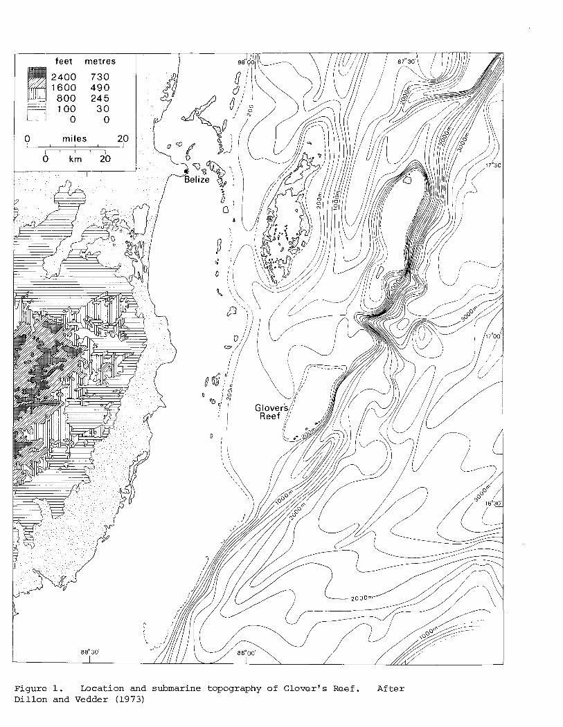
Figure 1. Location and submarine topography of Glover's Reef. After Dillon and Vedder (1973)

? k~ lornetres 5
1 I 1
Figure 2. Topography o f lover's Reef . From S t o d d a r t (1962, f i g . 3 7 )

PHYSICAL VEGETATION
Trees 1 Rubble
Shingle
Sand
Fresh sandspit
Undercut shoreline
Beach ridge - c r e s t
Beac hroc k
Phosphate rock
Peat
Marsh
NI Coconut; Coconut woodland (dense,open)
Q Rhizophora
-0- Avicennia
................................ .................................. .................................. Lagu ncularia :.:.:.:.:.:.>:.: ..........................
A COCCO~O b~
o Cord I a
M Mor i nda
F Ficus
T Term i na l ia
8 Bursera
Shrubs Tournefortia
Conocarpus
o Suriana
x lndetermi nate
Herbs Hymenocal Iis
Herbs and grosses
Figure 3. Legend t o the de ta i l ed physical and vegetat ion maps of the cays
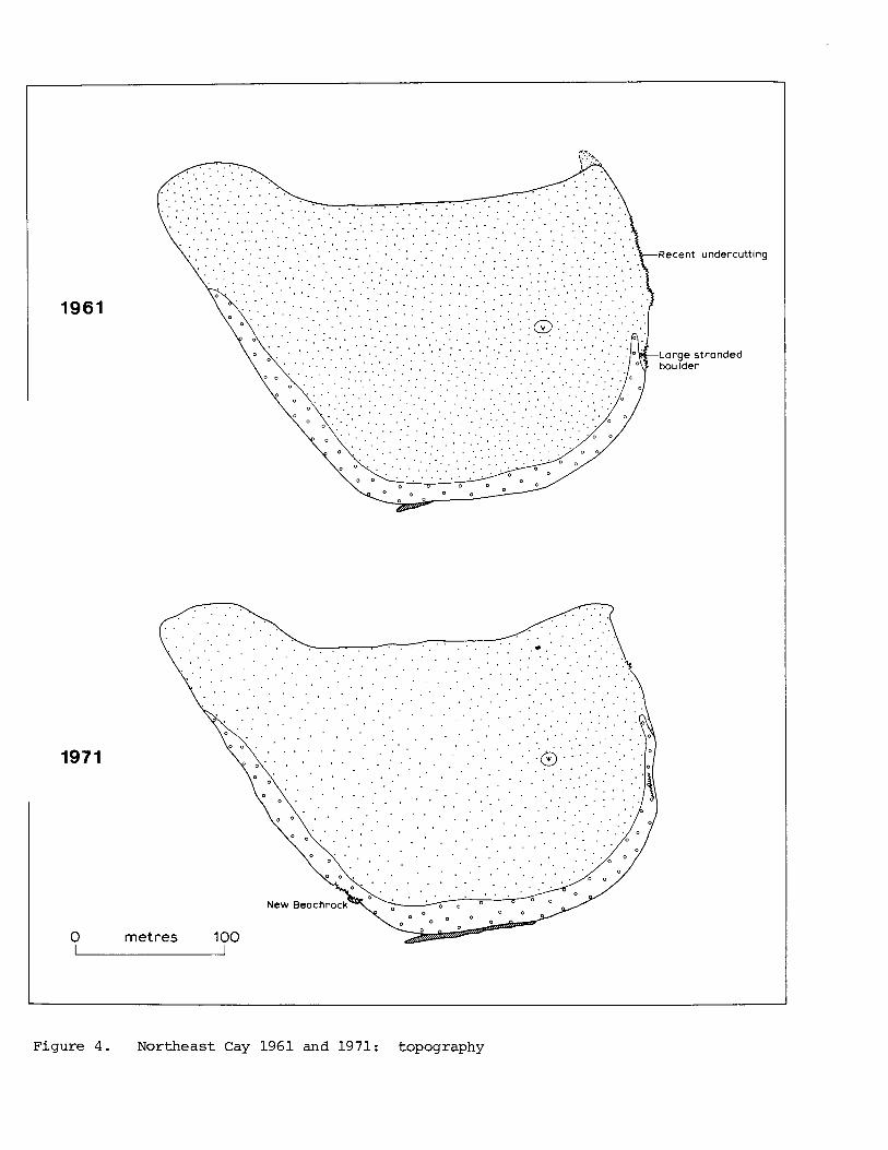
Figure 4 . Northeast Cay 1961 and 1971: topography
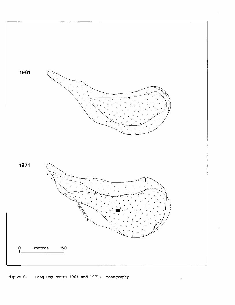
0 metres 50 - Figure 6. Long Cay North 1961 and 1971: topography
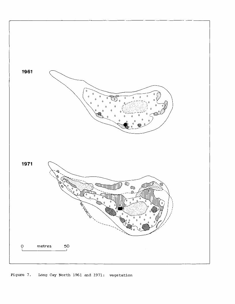
Figure 7. Long Cay North 1961 and 1971: v e g e t a t i o n
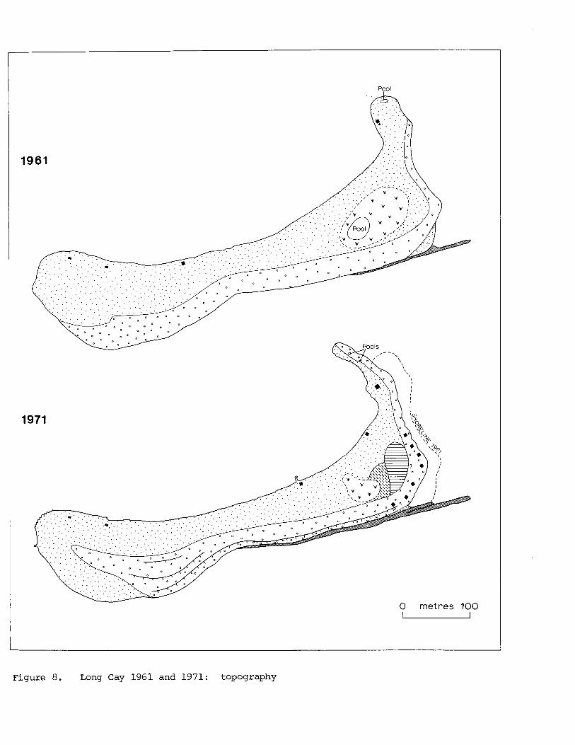
Figure 8. Long Cay 1961 and 1971: topography
Pool
0 metres 100 u
Figure 9. Long Cay 1961 and 1971: v e g e t a t i o n
0 metres 100 L
I
Figure 10. Middle Cay 1961 and 1971: topography
Figure 11. Middle Cay 1961 and 1971: v e g e t a t i o n
0 metres 100 u
Figure 12. Southwest Cay I 1961 and 1971: topography
0 metres 100
Figure 13. Southwest Cay I 1961 and 1971: v e g e t a t i o n
,--- , ' I ' ,' jl961 SHORELINE
! '.
?igure 14. Southwest Cay I1 1961 and 1971: topography
961 SHORELINE
metres 100
?igure 15. Southwest Cay I1 1961 and 1971: vegeta t ion
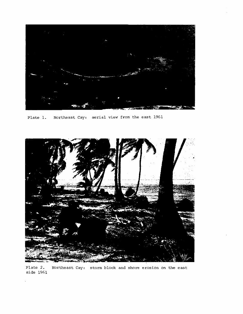
Pla te 1. Northeast Cay: a e r i a l view from the e a s t 1961
Pla te 2 . Northeast Cay: storm block and shore erosion on the e a s t s ide 1961
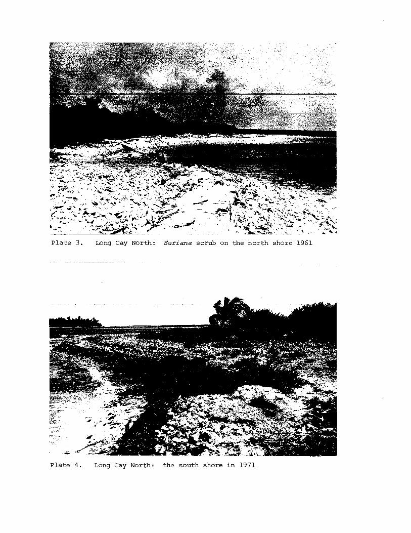
P l a t e 3 . Long Cay North: S u r i a n a scrub on the nor th shore 1961
- -. - --- - - -
P l a t e 4. Long Cay North: the south shore i n 1971
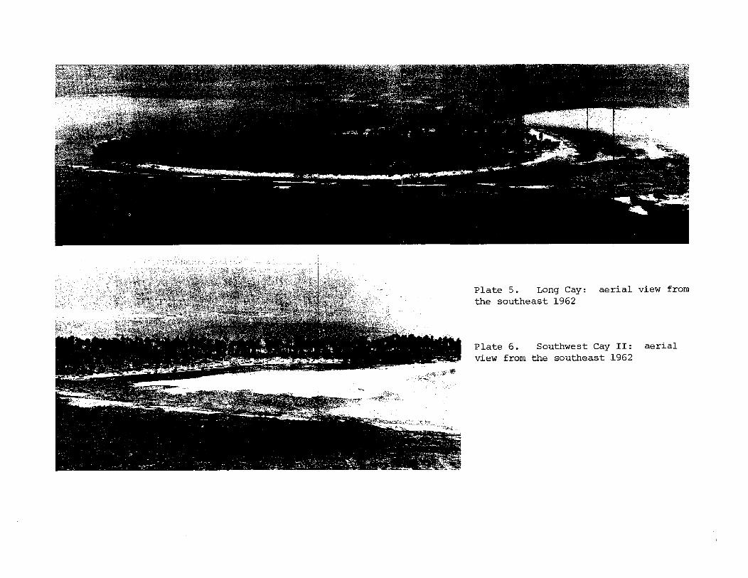
Pla te 5. Long Cay: a e r i a l view from the southeast 1962
P la te 6. Southwest Cay I1 : a e r i a l view from the southeast 1962
Pla te 7. Long Cay: Tournefortia on the nor theas t s p i t 1961
- -.
Pla te 8. Long Cay: upper surface of the windward shingle r idge 1961
P l a t e 9. Long Cay: sandy i s l a n d su r f ace with backslope of t he windward sh ing le r idge 1971
P l a t e 10. Long Cay: mud hole and s tanding water a t t he e a s t end, seen from the windward sh ing le r idge 1961
P l a t e 11. Middle Cay: windward sh ing le r idge with hedge of T o u r n e f o r t i a 1971
P l a t e 12. Middle Cay: low lagoon shore with Conocarpus 1971
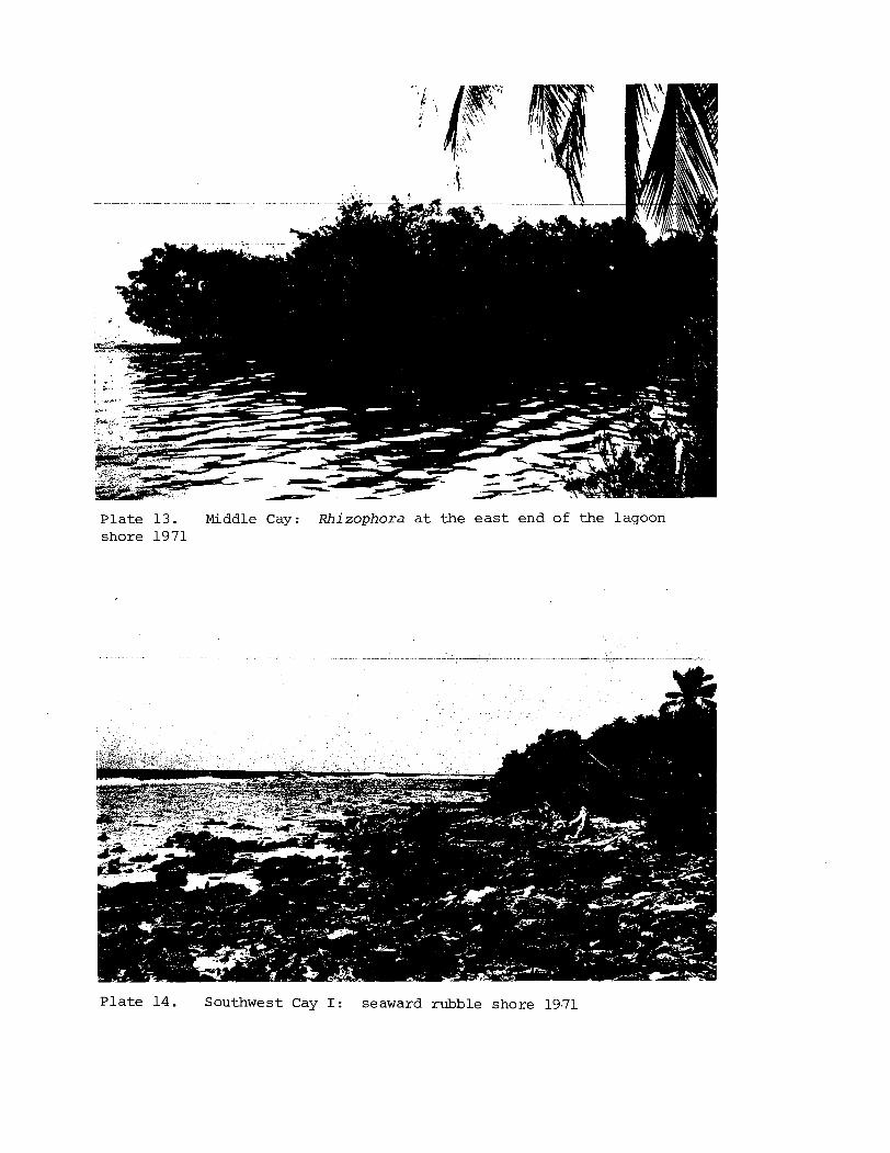
Plate 13. Middle Cay: Rhizophora a t the e a s t end of the lagoon shore 1971
P la te 14. Southwest Cay I: seaward rubble shore 19.71
P l a t e 15. Southwest Cay I : mangrove pool a t t h e southern end o f t h e i s l a n d 1961
P l a t e 16. Southwest Cay 11: exposed ' r oo t rock ' on t h e r e t r e a t i n g lagoon shore 1971
P l a t e 17. Southwest Cay I : open mangrove 1961 P l a t e 18. Southwest Cay 11: beachrock w i t h landward d i p on t h e seaward shore 1961