attachment 2015 annual report question #1 · pdf fileattachment 2015 annual report question...
TRANSCRIPT

Attachment 2015 Annual Report Question #1:
Attach a notification of any annexations, incorporations or jurisdictional boundary
changes resulting in an increase or decrease in the Permittee’s geographic area of
permit coverage during the reporting period per S9.D.6.
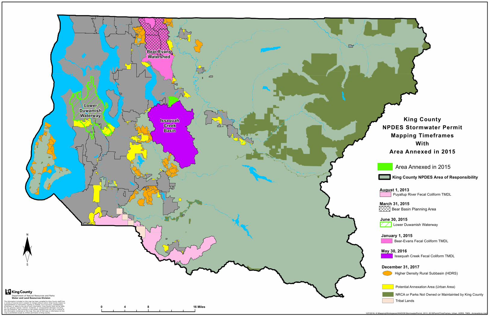
LowerDuwamishWaterway
IssaquahCreekBasin
Bear-EvansWatershed
Department of Natural Resources and ParksWater and Land Resources Division
1/27/2016, K:\Mapping\Workspaces\WADOE\StormwaterPermit_2013_2018\PermitTimeFrames_Urban_HDRS_TMDL_Annexations.mxd
King CountyNPDES Stormwater Permit
Mapping TimeframesWith
Area Annexed in 2015
0 8 164 Miles
¨
King County NPDES Area of Responsibility
August 1, 2013Puyallup River Fecal Coliform TMDL
January 1, 2015Bear-Evans Fecal Coliform TMDL
June 30, 2015Lower Duwamish Waterway
May 30, 2016Issaquah Creek Fecal Coliform TMDL
December 31, 2017Higher Density Rural Subbasin (HDRS)
Potential Annexation Area (Urban Area)NRCA or Parks Not Owned or Maintainted by King CountyTribal Lands
March 31, 2015Bear Basin Planning Area
Area Annexed in 2015

Attachment 2015 Annual Report Question #71:
For TMDL listed in Appendix 2: Attach a summary of relevant SWMP and
Appendix 2 activities to address the applicable TMDL parameter(s), (S7.A).
1
January 8, 2016 145 pm SWSS WQCU JED
King County Stormwater Services
Bear-Evans Creek FC TMDL Program 2015
Executive Summary
This document answers Question 71 of the questionnaire from the Washington State Department
of Ecology regarding King County’s Phase I NPDES Municipal Stormwater Permit
implementation activities for 2015.
In 2015 King County Stormwater Services staff continued the preparatory tasks begun in 2014
for bacteria source screening for the Bear-Evans Fecal Coliform Total Maximum Daily Load
(FC TMDL) as it relates to the stormwater system. Background details, including maps of
sample locations and sampling methods, are included in the Sampling and Analysis Plan (SAP)
submitted concurrently with this document. As a result of the work performed so far, no specific
sources of high bacteria, discharging to the creeks via the MS4, have been identified.
Additionally, Permit-required work regarding animal waste collection and education stations was
begun. A narrative of task descriptions is provided in this document.
Regulatory Requirements:
“Designate areas discharging via the MS4 to the TMDL area as high priority areas for illicit
discharge detection and elimination. Complete IDDE field screening for bacteria sources in 50
percent of MS4 subbasins, including rural MS4 subbasins, by February 2, 2017 and implement
the schedules and activities identified in S5.C.8 of the Phase I permit for response to any illicit
discharges found.”
“Install and maintain animal waste education and/or collection stations at municipal parks and
other Permittee owned and operated lands reasonably expected to have substantial animal (dog
and horse) use and the potential for pollution of stormwater.”
from Phase I NPDES Municipal Stormwater Permit 2013-2018, Appendix 2
Introduction: Work tasks were undertaken in 2015, including drafting and finalizing a Sampling
and Analysis Plan (SAP) to investigate sources of fecal coliform bacteria in the County’s
stormwater conveyance system. These were done to comply with the first requirement listed
above. This SAP has been submitted as an attachment accompanying this document, for
reference purposes. In-office inventorying of County-owned properties, for the second
requirement above, also began. Field, office and lab work were also undertaken and described in
this document or as detailed in the SAP. No illicit discharges or illicit connections have been
identified as a result of this work as yet.
Task Description Narrative: Work begun by Stormwater Services in 2014 for the Bear-Evans
FC TMDL continued and expanded in 2015. The following tasks were done:
2
January 8, 2016 145 pm SWSS WQCU JED
1. Completed initial wide-spread field reconnaissance in the basin to identify preliminary
sampling locations in the MS4; this work was folded into the SAP, which is described
below. As part of this effort, about 300 locations in the Bear-Evans basin where
stormwater leaves County MS4 jurisdiction were visited during dry weather, checking for
evidence of illicit discharges or illicit connections (dry weather flows, and other
visual/olfactory evidence).
2. The Sampling and Analysis Plan (SAP) was drafted and completed. The SAP contains
the following and may be consulted for these details:
Background, which describes basin (Bear, Evans and Cottage Lake Creeks)
Regulatory impetus
Map of overall basin, and map of MS4 subbasins
Project description, high level
Project management and project implementation staff
Project schedule
Sampling design
Sampling locations, including selection rationale and list by name and coordinates
Sampling location map, at time of SAP finalization in November 2015
Storm event targeting
Information to be acquired at each site
Proposed follow-up to synoptic sampling results
Sampling and measurement procedures
Quality control procedures, field and lab
Data management procedures
References
3. Conducted two synoptic field sampling events in the MS4 in October 2015 and
November 2015, following the work plan and guidelines in the SAP.
4. Performed in-house E. coli screening and bacterial laboratory analyses on these samples,
per the SAP.
5. Planning underway for a third synoptic event, to be done in early 2016; if one or more
additional synoptic events beyond a total of three can be scheduled, these will also be
done. Analytical results will be assessed from all three synoptic events, and will inform
No. 7 task (below).
6. Assessed historical and current in-creek bacteria data, as this data seems relevant to this
MS4 bacteria source screening work. In 2016 we will continue to analyze data collected
within other programs from in-creek stations. These programs include long-term bacteria
sampling, as well as additional sampling being implemented for a watershed modeling
study concurrently being done in Bear basin. These results will be assessed and used, if
warranted, to help bracket creek reaches which may have inputs of high bacteria from the
County’s MS4.
3
January 8, 2016 145 pm SWSS WQCU JED
7. Preliminary, conceptual planning was begun if high levels of bacteria are found in certain
locations, in the MS4 and/or within creek sampling stations. The goal is to conduct
source tracing to identify and eliminate anthropogenic or anthropogenic-related bacteria
sources, including but not limited to: failing septic systems; animal waste; and
improperly managed garbage (food, cooking oil). These are considered to have potential
to contribute elevated bacteria levels to the MS4.
8. Identified businesses in the Bear basin using existing inspection database, Google maps,
and County and State records. Conducted source control inspections to ensure required
stormwater best management practices were in place.
9. To comply with the second Permit requirement included above, an inventory process for
County owned and operated properties was undertaken, in order to ascertain if there are
any such properties reasonably expected to have substantial dog and horse use with the
potential to pollute stormwater. A prioritization process was devised and imposed,
whereby higher risk sites were identified to field visit (County owned or operated
properties within a certain distance of creeks or tributaries). These higher priority sites
will be field visited in 2016. If any County owned or operated sites are identified that
need animal waste collection or education stations, preliminary work to install these will
commence in 2016.
---------------------------------------End of report--------------------------------------------------
Sampling and Analysis Plan
Investigation of Fecal Coliform Sources in Bear/Evans Creek Stormwater Conveyance System
As required by the
Phase I NPDES Municipal Stormwater Permit 2013-2018, Appendix 2
November 2015
Prepared by:
Cameron Chapman and Jeanne Dorn
King County Department of Natural Resources and Parks

This page left intentionally blank
Sampling and Analysis Plan - i - November 2015
Table of Contents
1.0 Background ............................................................................................................................... 1
2.0 Project Description.................................................................................................................... 3
3.0 Organization and Schedule ....................................................................................................... 5
4.0 Sampling Design ........................................................................................................................ 7
4.1 Sampling approach and rationale ......................................................................................... 7
4.2 Sampling locations ................................................................................................................ 8
4.3 Targeting of storm events ................................................................................................... 14
4.4 Overview of information to be acquired at each site ......................................................... 14
4.5 Follow-up to initial sampling results ................................................................................... 15
4.6 Future changes to SAP ........................................................................................................ 16
5.0 Sampling Procedures .............................................................................................................. 17
5.1 Overview ............................................................................................................................. 17
5.2 Arrival at site ....................................................................................................................... 17
5.3 Sample acquisition .............................................................................................................. 17
5.4 Sample handling and processing ........................................................................................ 18
5.5 Field replicates and field blanks .......................................................................................... 18
5.6 Other measurements .......................................................................................................... 19
5.7 Documentation and custody procedures ........................................................................... 19
6.0 Measurement Procedures ...................................................................................................... 20
7.0 Quality Assurance/Quality Control Objectives ....................................................................... 21
7.1 Data quality objectives ....................................................................................................... 21
7.2 Laboratory QA/QC: King County Environmental Laboratory.............................................. 22
7.3 Laboratory QA/QC: Stormwater Services ........................................................................... 24
7.4 Field QA/QC: Stormwater Services ..................................................................................... 25
8.0 Data Management Procedures ............................................................................................... 26
8.1 Data review, reporting, verification, and validation requirements .................................... 26
8.2 Data Storage ....................................................................................................................... 28
9.0 References .............................................................................................................................. 29
Appendix A: Sampling Site Guide .................................................................................................. 30
Sampling and Analysis Plan - ii - November 2015
Figures and Tables
Figure 1. Bear-Evans Watershed (Washington State Department of Ecology) .............................. 2
Figure 2. Bear-Evans Creek Watershed MS4 Subbasins ................................................................. 4
Figure 3. Bear-Evans Watershed MS4 Sampling Locations .......................................................... 13
Table 1. Bear/Evans Fecal Coliform TMDL Sampling Sites.............................................................. 9
Table 2. Containers, sample size, and field preservation methods for collected samples .......... 18
Table 3. E. coli and Hu-2-Bacteroides methods ............................................................................ 20
Table 4. KCEL detection limits for E. coli and Hu-2-Bacteroides analyses .................................... 26
Table 5. KCEL qualifier codes ........................................................................................................ 27
Sampling and Analysis Plan - 1 - November 2015
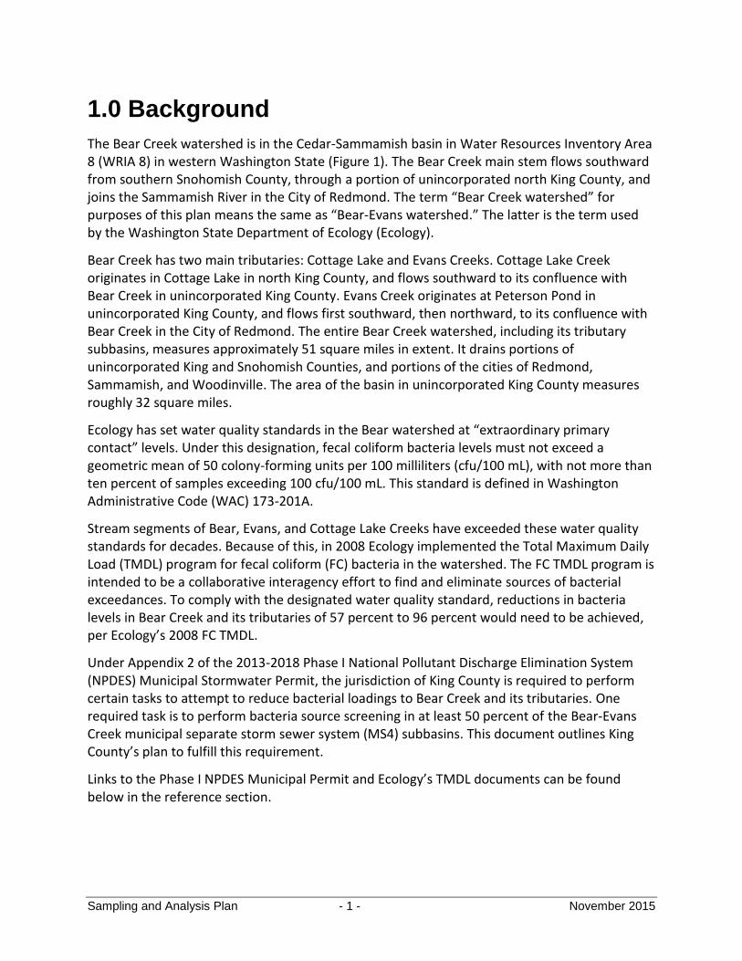
1.0 Background
The Bear Creek watershed is in the Cedar-Sammamish basin in Water Resources Inventory Area 8 (WRIA 8) in western Washington State (Figure 1). The Bear Creek main stem flows southward from southern Snohomish County, through a portion of unincorporated north King County, and joins the Sammamish River in the City of Redmond. The term “Bear Creek watershed” for purposes of this plan means the same as “Bear-Evans watershed.” The latter is the term used by the Washington State Department of Ecology (Ecology).
Bear Creek has two main tributaries: Cottage Lake and Evans Creeks. Cottage Lake Creek originates in Cottage Lake in north King County, and flows southward to its confluence with Bear Creek in unincorporated King County. Evans Creek originates at Peterson Pond in unincorporated King County, and flows first southward, then northward, to its confluence with Bear Creek in the City of Redmond. The entire Bear Creek watershed, including its tributary subbasins, measures approximately 51 square miles in extent. It drains portions of unincorporated King and Snohomish Counties, and portions of the cities of Redmond, Sammamish, and Woodinville. The area of the basin in unincorporated King County measures roughly 32 square miles.
Ecology has set water quality standards in the Bear watershed at “extraordinary primary contact” levels. Under this designation, fecal coliform bacteria levels must not exceed a geometric mean of 50 colony-forming units per 100 milliliters (cfu/100 mL), with not more than ten percent of samples exceeding 100 cfu/100 mL. This standard is defined in Washington Administrative Code (WAC) 173-201A.
Stream segments of Bear, Evans, and Cottage Lake Creeks have exceeded these water quality standards for decades. Because of this, in 2008 Ecology implemented the Total Maximum Daily Load (TMDL) program for fecal coliform (FC) bacteria in the watershed. The FC TMDL program is intended to be a collaborative interagency effort to find and eliminate sources of bacterial exceedances. To comply with the designated water quality standard, reductions in bacteria levels in Bear Creek and its tributaries of 57 percent to 96 percent would need to be achieved, per Ecology’s 2008 FC TMDL.
Under Appendix 2 of the 2013-2018 Phase I National Pollutant Discharge Elimination System (NPDES) Municipal Stormwater Permit, the jurisdiction of King County is required to perform certain tasks to attempt to reduce bacterial loadings to Bear Creek and its tributaries. One required task is to perform bacteria source screening in at least 50 percent of the Bear-Evans Creek municipal separate storm sewer system (MS4) subbasins. This document outlines King County’s plan to fulfill this requirement.
Links to the Phase I NPDES Municipal Permit and Ecology’s TMDL documents can be found below in the reference section.

Sampling and Analysis Plan - 2 - November 2015
Figure 1. Bear-Evans Watershed (Washington State Department of Ecology)

Sampling and Analysis Plan - 3 - November 2015
2.0 Project Description
Under the 2013-2018 Phase I NPDES Municipal Stormwater Permit, King County has two specific requirements relating to the fecal coliform TMDL for the Bear Creek watershed:
Install and maintain animal waste education and/or collection stations at municipal parks and other Permittee owned and operated lands reasonably expected to have substantial domestic animal (dog and horse) use and the potential for pollution of stormwater.
Designate areas discharging via the MS4 to the TMDL area as high priority areas for illicit discharge detection and elimination (IDDE). Complete IDDE field screening for bacteria sources in 50 percent of MS4 subbasins, including rural MS4 subbasins, by February 2, 2017, and implement the schedules and activities identified in S5.C.8 of the Phase I permit for response to any illicit discharges found.
This document describes King County’s tasks to achieve the second of the above two requirements. Staff from King County’s Stormwater Services (SWS) will lead this effort, with assistance from King County’s Science and Technical Support Section.
SWS will conduct both dry- and wet-season screening activities during the project period. Dry-season activities include visual and olfactory observations of the County’s MS4, field analyses of dry-weather flows, and more detailed source tracing of suspect flows. Wet-season activities, which are the primary focus of this document, will include synoptic sampling of storm flows at select locations in the MS4, in-house analysis for Escherichia coli, laboratory analysis for human Bacteroides at sites testing high in E. coli, and more detailed source tracing of suspect flows.
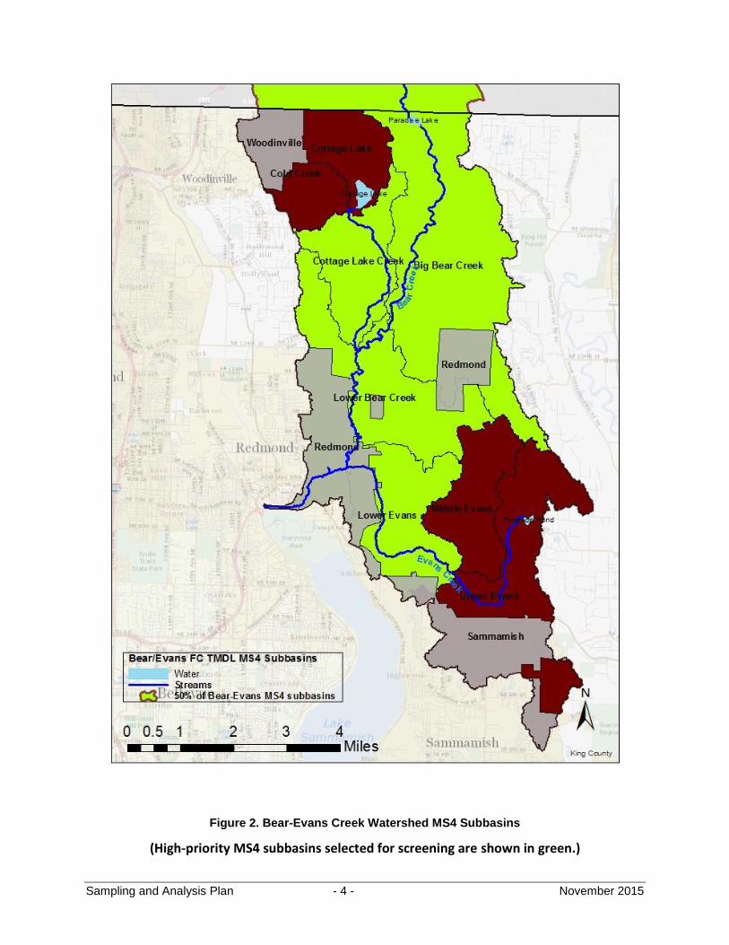
For purposes of this project, Ecology’s term “MS4 subbasin” is taken to mean a topographic subbasin in which stormwater is conveyed by an MS4. According to the schema of King County’s existing GIS data, there are eight topographic subbasins in the Bear/Evans/Cottage Lake Creek system. Thus, to achieve the requirement to screen 50 percent of the subbasins, four subbasins were chosen for this project and are shown in green in Figure 2. The collective size of these four subbasins, and the large number of MS4 features found therein, precludes the screening of the County’s entire MS4 within the watershed. Both dry-weather and wet-weather screening will take place in each subbasin, but the ultimate prioritization of (and partitioning of resources among) these four subbasins will be based on a review of available information, including historic water quality data, location of on-site septic systems, and age of home construction.
The remainder of this document provides a more detailed description of SWS’s plan to perform wet-weather bacteria screening in these four subbasins.
Sampling and Analysis Plan - 4 - November 2015
Figure 2. Bear-Evans Creek Watershed MS4 Subbasins
(High-priority MS4 subbasins selected for screening are shown in green.)
Sampling and Analysis Plan - 5 - November 2015
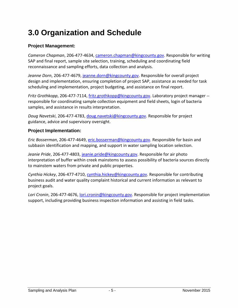
3.0 Organization and Schedule
Project Management:
Cameron Chapman, 206-477-4634, [email protected]. Responsible for writing SAP and final report, sample site selection, training, scheduling and coordinating field reconnaissance and sampling efforts, data collection and analysis.
Jeanne Dorn, 206-477-4679, [email protected]. Responsible for overall project design and implementation, ensuring completion of project SAP, assistance as needed for task scheduling and implementation, project budgeting, and assistance on final report.
Fritz Grothkopp, 206-477-7114, [email protected]. Laboratory project manager -- responsible for coordinating sample collection equipment and field sheets, login of bacteria samples, and assistance in results interpretation.
Doug Navetski, 206-477-4783, [email protected]. Responsible for project guidance, advice and supervisory oversight.
Project Implementation:
Eric Bosserman, 206-477-4649, [email protected]. Responsible for basin and subbasin identification and mapping, and support in water sampling location selection.
Jeanie Pride, 206-477-4803, [email protected]. Responsible for air photo interpretation of buffer within creek mainstems to assess possibility of bacteria sources directly to mainstem waters from private and public properties.
Cynthia Hickey, 206-477-4710, [email protected]. Responsible for contributing business audit and water quality complaint historical and current information as relevant to project goals.
Lori Cronin, 206-477-4676, [email protected]. Responsible for project implementation support, including providing business inspection information and assisting in field tasks.
Sampling and Analysis Plan - 6 - November 2015
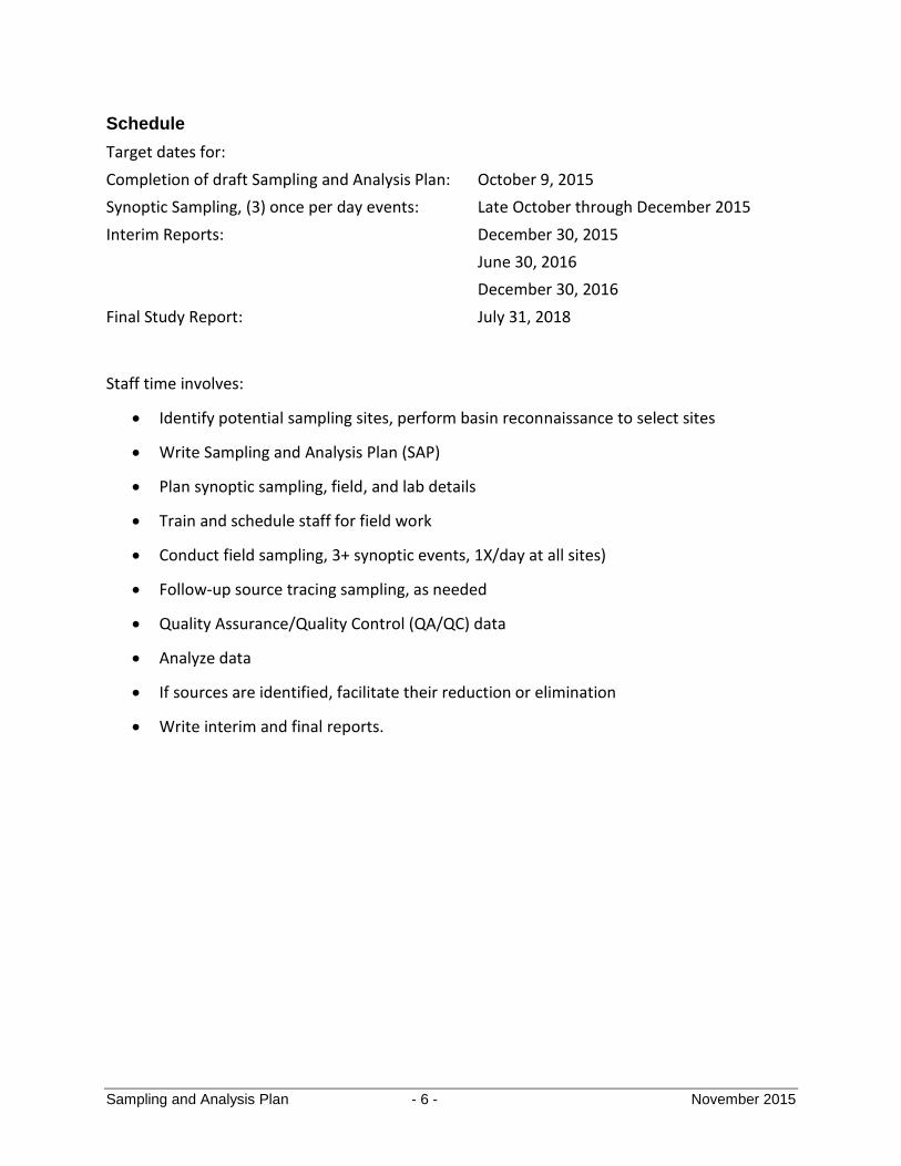
Schedule
Target dates for:
Completion of draft Sampling and Analysis Plan: October 9, 2015
Synoptic Sampling, (3) once per day events: Late October through December 2015
Interim Reports: December 30, 2015
June 30, 2016
December 30, 2016
Final Study Report: July 31, 2018
Staff time involves:
Identify potential sampling sites, perform basin reconnaissance to select sites
Write Sampling and Analysis Plan (SAP)
Plan synoptic sampling, field, and lab details
Train and schedule staff for field work
Conduct field sampling, 3+ synoptic events, 1X/day at all sites)
Follow-up source tracing sampling, as needed
Quality Assurance/Quality Control (QA/QC) data
Analyze data
If sources are identified, facilitate their reduction or elimination
Write interim and final reports.
Sampling and Analysis Plan - 7 - November 2015
4.0 Sampling Design
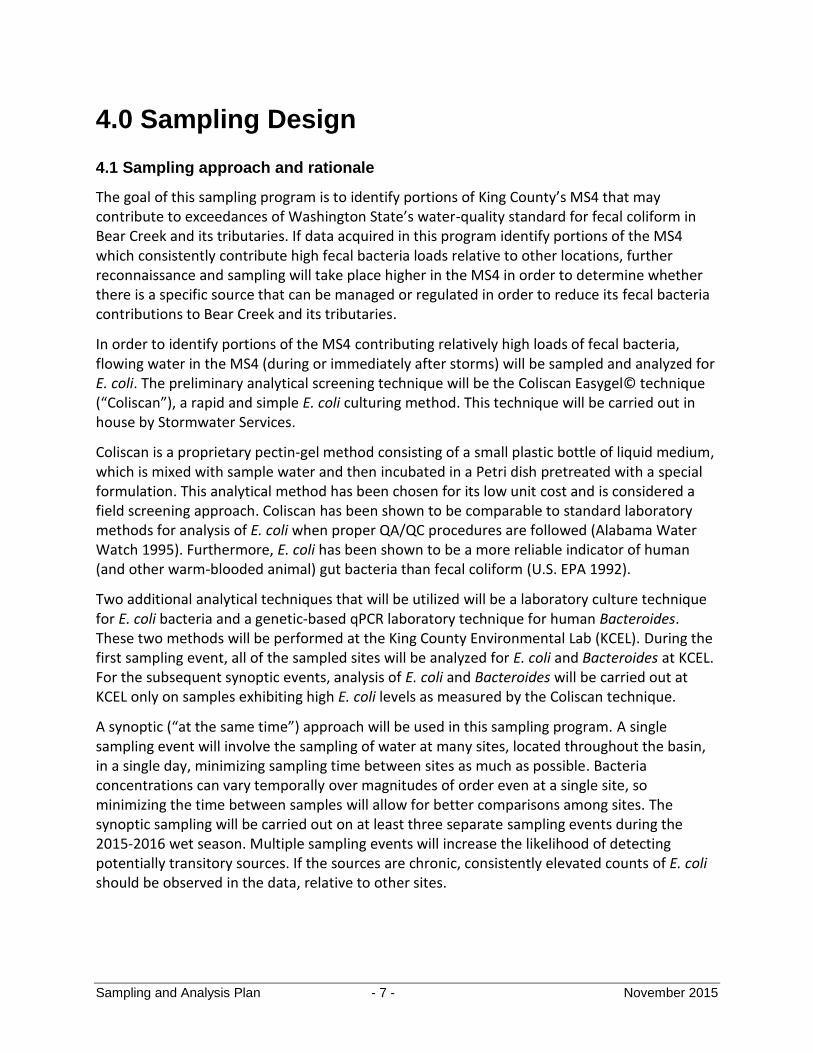
4.1 Sampling approach and rationale
The goal of this sampling program is to identify portions of King County’s MS4 that may contribute to exceedances of Washington State’s water-quality standard for fecal coliform in Bear Creek and its tributaries. If data acquired in this program identify portions of the MS4 which consistently contribute high fecal bacteria loads relative to other locations, further reconnaissance and sampling will take place higher in the MS4 in order to determine whether there is a specific source that can be managed or regulated in order to reduce its fecal bacteria contributions to Bear Creek and its tributaries.
In order to identify portions of the MS4 contributing relatively high loads of fecal bacteria, flowing water in the MS4 (during or immediately after storms) will be sampled and analyzed for E. coli. The preliminary analytical screening technique will be the Coliscan Easygel© technique (“Coliscan”), a rapid and simple E. coli culturing method. This technique will be carried out in house by Stormwater Services.
Coliscan is a proprietary pectin-gel method consisting of a small plastic bottle of liquid medium, which is mixed with sample water and then incubated in a Petri dish pretreated with a special formulation. This analytical method has been chosen for its low unit cost and is considered a field screening approach. Coliscan has been shown to be comparable to standard laboratory methods for analysis of E. coli when proper QA/QC procedures are followed (Alabama Water Watch 1995). Furthermore, E. coli has been shown to be a more reliable indicator of human (and other warm-blooded animal) gut bacteria than fecal coliform (U.S. EPA 1992).
Two additional analytical techniques that will be utilized will be a laboratory culture technique for E. coli bacteria and a genetic-based qPCR laboratory technique for human Bacteroides. These two methods will be performed at the King County Environmental Lab (KCEL). During the first sampling event, all of the sampled sites will be analyzed for E. coli and Bacteroides at KCEL. For the subsequent synoptic events, analysis of E. coli and Bacteroides will be carried out at KCEL only on samples exhibiting high E. coli levels as measured by the Coliscan technique.
A synoptic (“at the same time”) approach will be used in this sampling program. A single sampling event will involve the sampling of water at many sites, located throughout the basin, in a single day, minimizing sampling time between sites as much as possible. Bacteria concentrations can vary temporally over magnitudes of order even at a single site, so minimizing the time between samples will allow for better comparisons among sites. The synoptic sampling will be carried out on at least three separate sampling events during the 2015-2016 wet season. Multiple sampling events will increase the likelihood of detecting potentially transitory sources. If the sources are chronic, consistently elevated counts of E. coli should be observed in the data, relative to other sites.
Sampling and Analysis Plan - 8 - November 2015
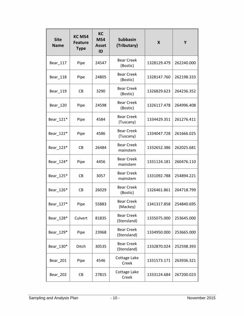
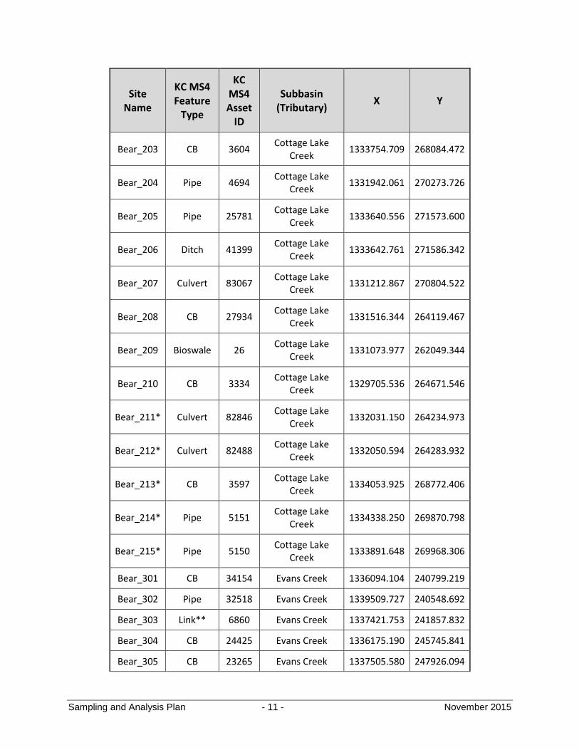
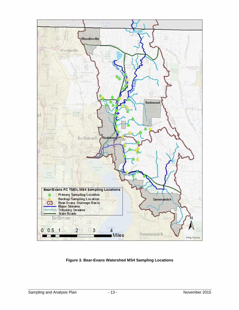
4.2 Sampling locations
Forty sites are initially planned for synoptic bacteria screening (Table 1 and Figure 3). The number of sampling sites is constrained by the number of locations that can be safely visited and sampled within a three- to four-hour period. During each synoptic event, two teams of two people will each visit approximately 20 sites. The remainder of the work day will be used for travel to and from the study area, as well as for post-event sample processing.
All sites are located in the public road right-of-way or are on King-County-owned property. Samples will be taken from the County’s MS4, which consists of pipes, ditches, catch basins, stormwater ponds, and bioswales. No natural stream channels or wetlands will be sampled, unless it is determined that the water encountered therein is largely stormwater runoff originating in the County’s MS4 (see site Bear_117). Streams or wetlands may also be sampled if there is a pollution concern relating to nearby land use practices (see site Bear_302).
Sampling sites have been chosen based on their proximity to the main stem of Bear Creek and its tributaries, accessibility from the public right-of-way, safety of access, size of area draining to the location, and the likelihood that the location will convey stormwater during storms. Other factors, including domestic-animal-related land uses, and the likelihood of being impacted by groundwater or surface water flow from residences with septic systems, have also been taken into consideration.
In addition to the 40 sites identified in Table 1, 20 sites are designated as “backups” in case no flow is encountered at any of the initial 40 sites. The backup sites are listed in Table 2. In any case, the total number of sites sampled in the initial synoptic will not be greater than 40.
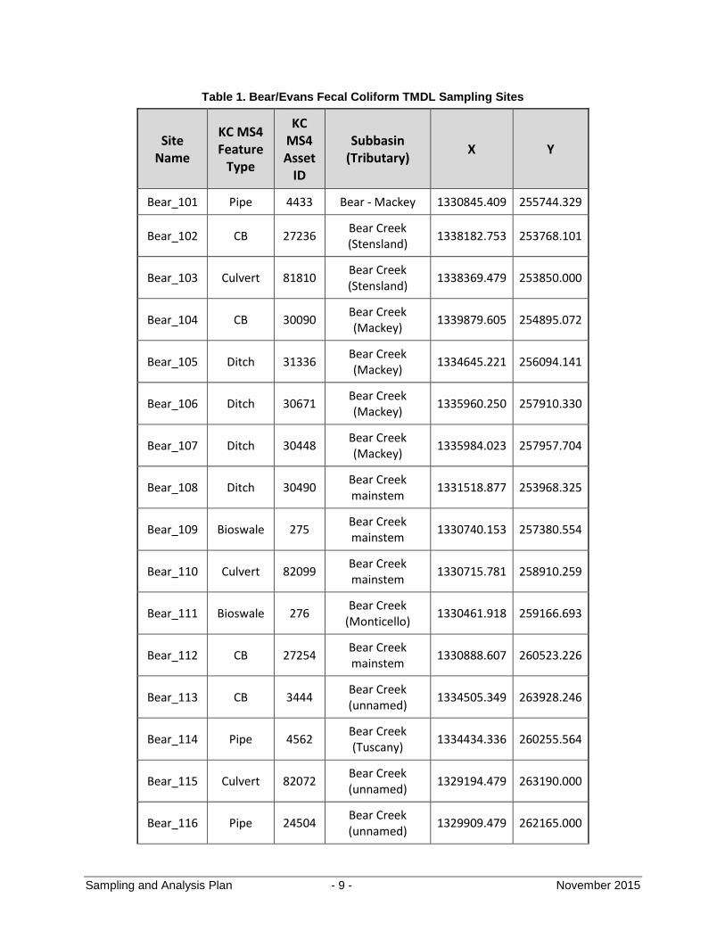
Sampling and Analysis Plan - 9 - November 2015
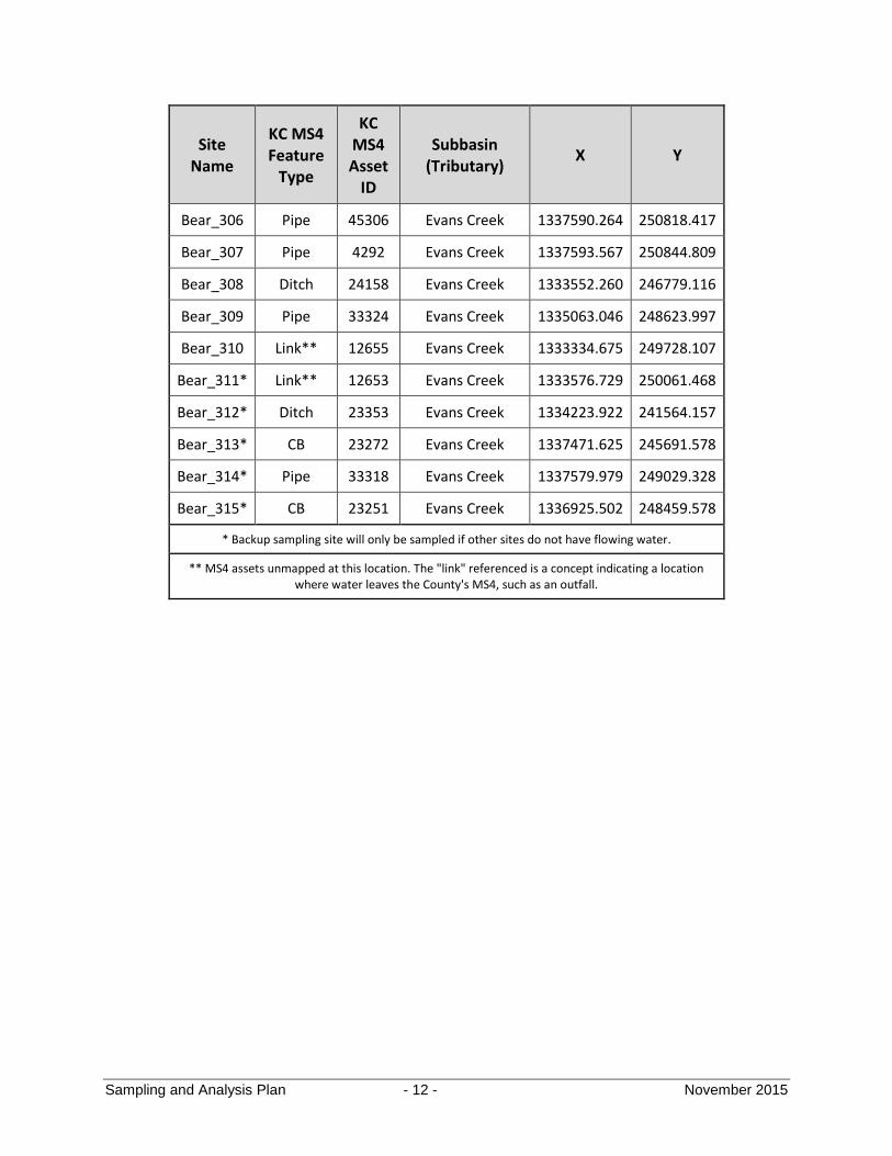
Table 1. Bear/Evans Fecal Coliform TMDL Sampling Sites
Site Name
KC MS4 Feature
Type
KC MS4 Asset
ID
Subbasin (Tributary)
X Y
Bear_101 Pipe 4433 Bear - Mackey 1330845.409 255744.329
Bear_102 CB 27236 Bear Creek (Stensland)
1338182.753 253768.101
Bear_103 Culvert 81810 Bear Creek (Stensland)
1338369.479 253850.000
Bear_104 CB 30090 Bear Creek (Mackey)
1339879.605 254895.072
Bear_105 Ditch 31336 Bear Creek (Mackey)
1334645.221 256094.141
Bear_106 Ditch 30671 Bear Creek (Mackey)
1335960.250 257910.330
Bear_107 Ditch 30448 Bear Creek (Mackey)
1335984.023 257957.704
Bear_108 Ditch 30490 Bear Creek mainstem
1331518.877 253968.325
Bear_109 Bioswale 275 Bear Creek mainstem
1330740.153 257380.554
Bear_110 Culvert 82099 Bear Creek mainstem
1330715.781 258910.259
Bear_111 Bioswale 276 Bear Creek
(Monticello) 1330461.918 259166.693
Bear_112 CB 27254 Bear Creek mainstem
1330888.607 260523.226
Bear_113 CB 3444 Bear Creek (unnamed)
1334505.349 263928.246
Bear_114 Pipe 4562 Bear Creek (Tuscany)
1334434.336 260255.564
Bear_115 Culvert 82072 Bear Creek (unnamed)
1329194.479 263190.000
Bear_116 Pipe 24504 Bear Creek (unnamed)
1329909.479 262165.000
Sampling and Analysis Plan - 10 - November 2015
Site Name
KC MS4 Feature
Type
KC MS4 Asset
ID
Subbasin (Tributary)
X Y
Bear_117 Pipe 24547 Bear Creek
(Bostic) 1328129.479 262240.000
Bear_118 Pipe 24805 Bear Creek
(Bostic) 1328147.760 262198.333
Bear_119 CB 3290 Bear Creek
(Bostic) 1326829.623 264236.352
Bear_120 Pipe 24598 Bear Creek
(Bostic) 1326117.478 264996.408
Bear_121* Pipe 4584 Bear Creek (Tuscany)
1334429.351 261276.411
Bear_122* Pipe 4586 Bear Creek (Tuscany)
1334047.728 261666.025
Bear_123* CB 26484 Bear Creek mainstem
1332652.386 262025.681
Bear_124* Pipe 4456 Bear Creek mainstem
1331124.181 260476.110
Bear_125* CB 3057 Bear Creek mainstem
1331092.788 254894.221
Bear_126* CB 26029 Bear Creek
(Bostic) 1326461.861 264718.799
Bear_127* Pipe 55883 Bear Creek (Mackey)
1341317.858 254840.695
Bear_128* Culvert 81835 Bear Creek (Stensland)
1335075.000 253645.000
Bear_129* Pipe 23968 Bear Creek (Stensland)
1334950.000 253665.000
Bear_130* Ditch 30535 Bear Creek (Stensland)
1332870.024 252598.393
Bear_201 Pipe 4546 Cottage Lake
Creek 1331573.171 263936.321
Bear_202 CB 27815 Cottage Lake
Creek 1333124.684 267200.023
Sampling and Analysis Plan - 11 - November 2015
Site Name
KC MS4 Feature
Type
KC MS4 Asset
ID
Subbasin (Tributary)
X Y
Bear_203 CB 3604 Cottage Lake
Creek 1333754.709 268084.472
Bear_204 Pipe 4694 Cottage Lake
Creek 1331942.061 270273.726
Bear_205 Pipe 25781 Cottage Lake
Creek 1333640.556 271573.600
Bear_206 Ditch 41399 Cottage Lake
Creek 1333642.761 271586.342
Bear_207 Culvert 83067 Cottage Lake
Creek 1331212.867 270804.522
Bear_208 CB 27934 Cottage Lake
Creek 1331516.344 264119.467
Bear_209 Bioswale 26 Cottage Lake
Creek 1331073.977 262049.344
Bear_210 CB 3334 Cottage Lake
Creek 1329705.536 264671.546
Bear_211* Culvert 82846 Cottage Lake
Creek 1332031.150 264234.973
Bear_212* Culvert 82488 Cottage Lake
Creek 1332050.594 264283.932
Bear_213* CB 3597 Cottage Lake
Creek 1334053.925 268772.406
Bear_214* Pipe 5151 Cottage Lake
Creek 1334338.250 269870.798
Bear_215* Pipe 5150 Cottage Lake
Creek 1333891.648 269968.306
Bear_301 CB 34154 Evans Creek 1336094.104 240799.219
Bear_302 Pipe 32518 Evans Creek 1339509.727 240548.692
Bear_303 Link** 6860 Evans Creek 1337421.753 241857.832
Bear_304 CB 24425 Evans Creek 1336175.190 245745.841
Bear_305 CB 23265 Evans Creek 1337505.580 247926.094
Sampling and Analysis Plan - 12 - November 2015
Site Name
KC MS4 Feature
Type
KC MS4 Asset
ID
Subbasin (Tributary)
X Y
Bear_306 Pipe 45306 Evans Creek 1337590.264 250818.417
Bear_307 Pipe 4292 Evans Creek 1337593.567 250844.809
Bear_308 Ditch 24158 Evans Creek 1333552.260 246779.116
Bear_309 Pipe 33324 Evans Creek 1335063.046 248623.997
Bear_310 Link** 12655 Evans Creek 1333334.675 249728.107
Bear_311* Link** 12653 Evans Creek 1333576.729 250061.468
Bear_312* Ditch 23353 Evans Creek 1334223.922 241564.157
Bear_313* CB 23272 Evans Creek 1337471.625 245691.578
Bear_314* Pipe 33318 Evans Creek 1337579.979 249029.328
Bear_315* CB 23251 Evans Creek 1336925.502 248459.578
* Backup sampling site will only be sampled if other sites do not have flowing water.
** MS4 assets unmapped at this location. The "link" referenced is a concept indicating a location where water leaves the County's MS4, such as an outfall.
Sampling and Analysis Plan - 13 - November 2015
Figure 3. Bear-Evans Watershed MS4 Sampling Locations
Sampling and Analysis Plan - 14 - November 2015
4.3 Targeting of storm events
Targeting of storm events will begin after October 19, 2015. Currently, it is not known how much rain is needed to make the various portions of the MS4 discharge stormwater to Bear Creek and its tributaries.
A rainfall event of at least 0.25 inches of precipitation will be used as a trigger to initiate synoptic sampling. Observations made in the wet season might lead to this trigger being altered, in order to ensure that all or most sites can be sampled in a single event. Rainfall depths will be estimated from real-time, telemetered rain gauges in the study basin maintained by King County’s Hydrologic Information Center. National Weather Service and University of Washington rain gauges will be used to fill in any data gaps. National Weather Service base reflectivity radar will also be used for real-time decision making. Sampling events will be separated by at least one week, in order to ensure that sampling events are independent from one another.
Bacterial samples collected at the beginning of a storm event are most desired, in order to capture the “first flush.” For this program, unfortunately, the time during which samples can be acquired is limited by the workday hours of County staff. Samples submitted to KCEL for E. coli analysis can only be collected between Monday and Wednesday, due to the 24-hour maximum hold time for bacterial analyses. Samples collected late on a Wednesday would typically not be turned in to KCEL until early Thursday (before the 24-hour maximum hold time), at which time the samples would be cultured and then analyzed prior to the weekend. Samples not analyzed by KCEL for E. coli can be collected anytime between Monday and Friday. Due to the length of the work day and the estimated time needed for travel and sampling, staff will not depart King Street Center (KSC) earlier than 7 a.m. or later than 12 p.m. to begin sampling.
Bacterial data acquired during this sampling program will be analyzed, taking into account hydrologic variables (e.g., precipitation and stream flow). The time of sample acquisition will be compared to rainfall hyetographs and streamflow hydrographs to determine whether bacteria levels appear to be impacted by these factors. Adjustments to the sampling plan, if practical, will be made in response to this analysis.
4.4 Overview of information to be acquired at each site
At each site visited, sampling personnel will collect the following:
Five-hundred milliliters of stormwater in a sterile bacteria sampling bottle, to be submitted to KCEL for Hu-2-Bacteroides and E. coli analyses in the first synoptic event, and held for possible submittal to KCEL in the next two synoptic events
Two five-milliliter aliquots of stormwater, each to be dispensed into a separate Coliscan gel bottle
A photo of the exact location where the sample was acquired; and

Sampling and Analysis Plan - 15 - November 2015
A rough measurement of the depth of flow and/or a qualitative description of the amount of flow encountered at the sampling point.
Further details, including information on QA/QC controls, are found in the Sampling Procedures section of this document.
4.5 Follow-up to initial sampling results
The first synoptic sampling event will include culturing of all samples at KSC using the Coliscan method. Additionally, all 500-mL sample bottles will be submitted to KCEL for human Bacteroides and E. coli analyses. Sites with high Bacteroides will be noted for possible source tracking follow-up work. The KCEL E. coli sample result will be compared to the Coliscan E. coli sample result for each site as a reliability check on the Coliscan method. If there is not a strong positive correlation between the two results, the Coliscan method will be examined to determine the causal factor(s) that could explain the difference between methods, and alternate approaches to standard use of the Coliscans may be explored. As an example, samples from sites with previously high E. coli counts may be replicated using smaller volumes of sample water (e.g., 0.1 mL or 1 mL), allowing for a better estimate when counting in-house. Previous experience shows that it is difficult to accurately count Coliscan samples with large numbers of E. coli colonies.
For remaining synoptic events, it is anticipated that only selected sample locations will be tested at KCEL for human Bacteroides and E. coli. For these events, a preliminary count will be made of all Coliscan plates early in the morning of the day following the synoptic, before 24 hours have passed since sample acquisition. Sites where both replicates contain greater than 240 cfu/100 mL will be identified. The 500-mL samples from these sites will then be delivered immediately to KCEL (so as not to violate holding time requirements) and analyzed for E. coli and human Bacteroides. (If only one replicate contains greater than 240 cfu/100 mL, best professional judgment will be used in determining whether or not to submit to KCEL.) After the preliminary count, the Coliscan plates will be left to incubate for the remainder of the 24-hour incubation period, at which time the official count will be made.
Source tracking will not be initiated based on the data from a single synoptic event. High Bacteroides levels will need to be confirmed in additional synoptic sampling events before source tracking is initiated.
After three synoptic sampling events, there will be at least three independent E. coli observations for each site. Any sites with less than 60 cfu/100 mL in all three samples will be removed from the sampling program, and will be replaced by a backup site (Figure 3) in order to maintain or expand coverage. Any sites that consistently have high E. coli levels relative to other sites will be chosen for source tracking – a single additional site will be added at a strategically chosen, up-pipe or up-ditch location in the MS4. Sites that do not fit one of the two described scenarios will remain in the sampling program and continue to be sampled in future synoptic events.
Sampling and Analysis Plan - 16 - November 2015
At this time, it is impossible to outline all the possible scenarios that could be encountered during sampling acquisition and data analysis. The basic approach will be to use available staff resources to follow up at any sites where measurements suggest a potential problem. If many potential problems are encountered, a triage approach will be used to focus on the “hottest” spots.
4.6 Future changes to SAP
The goal of this project is to find and eliminate anthropogenic sources of fecal coliform bacteria entering the County’s MS4 within the Bear-Evans Watershed. The methods used are those deemed most likely to find said sources. As such, certain details of the project’s sampling design or procedures may be abandoned and other, more useful methods may be adopted. Addenda will be made to the SAP over the course of the first wet season (2015-2016) to document any changes made. An updated SAP will be created, incorporating the various addenda, in preparation for the second wet-season sampling period in 2016-2017.
Sampling and Analysis Plan - 17 - November 2015
5.0 Sampling Procedures
5.1 Overview
At each sampling site, a 500-mL polypropylene bottle will be filled with stormwater flowing in the County’s MS4. From this bottle, two 5-mL aliquots will be pipetted. Each aliquot will be dispensed into a separate Coliscan gel bottle, which will be incubated later that day at KSC for E. coli analysis. The following provides a detailed description of the procedures to be followed at each sampling site.
5.2 Arrival at site
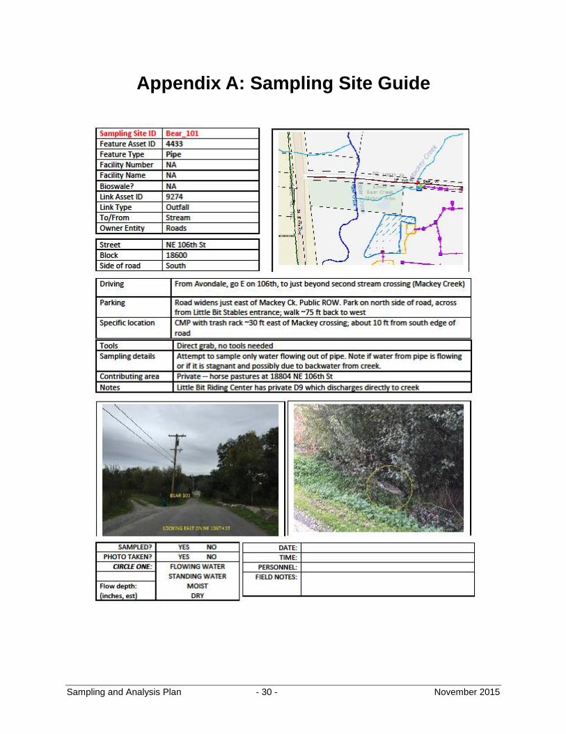
A field sheet has been created for each sampling location. This sheet includes a map and photo of the site and a text description of the location, including the asset ID of the feature to be sampled, tools that will be needed to acquire the sample, and driving directions to the site. Sampling personnel will use this field sheet along with SWS’s Collector App for iPhone (and GPS) to positively identify the sampling location. Most or all sites will also be tagged with pink flagging and/or yellow crayon. An example the field sheet is given in Appendix A.
With the sampling site located and the necessary tools in hand, the sample may be acquired. First, however, at least one photo of the site should be taken. The photo should be taken of the exact location sampled. The quantity of water flowing at the point should be evident in the photo. For samples taken from catch basins or manholes, two photos should be taken – one at street level and one looking down into the structure (preferably with a flash).
Sampling personnel will wear appropriate safety gear at each site, including steel-toed boots, high-visibility vests or jackets, hard hats, and gloves.
5.3 Sample acquisition
In general, only flowing water will be sampled, in order to accurately characterize water leaving the MS4 and entering the streams. Standing water in ditches, ponds, and catch basins will not be sampled unless there is evidence that water has been flowing past the point in the last two hours. Lack of flow will be noted on the field sheets.
At each site, sampling personnel will fill one 500-mL, sterile, polypropylene bottle with water flowing in the MS4. One inch of headspace should be left in the bottle. The 500-mL container must not be pre-rinsed with sample prior to collection. Each 500-mL bottle will be labeled with the lab sample number, the site ID, the date and time of sample acquisition, and the requested analyses to be performed.
Samples will be collected by the manual direct fill method. If this method is not possible due to safety considerations, personnel will use a telescoping sampling pole fitted with a swivel-head polypropylene or stainless-steel bailer. The 500-mL bottle will be situated inside the bailer to allow for direct fill. If this method is not practicable, sample water will be acquired in the bailer itself and decanted into the 500-mL bottle. The bailer will be triple-rinsed with R.O. or distilled
Sampling and Analysis Plan - 18 - November 2015
water after each use, and will also be rinsed with sample water thrice prior to sample acquisition.
From the 500-mL sample, two 5-mL aliquots will be pipetted. Each aliquot will be dispensed into a separate Coliscan gel bottle, each of which will be thawed and pre-marked with the sample site ID prior to dispensing. The same pipette tip may be used for each aliquot, but must be discarded after sampling at each site.
5.4 Sample handling and processing
All samples will be immediately placed in coolers with chilled blue ice. Coliscan samples will be transported as soon as possible to the King Street Center, 201 South Jackson Street, Seattle, WA 98104, Lab Room PA09, near the garage entrance/exit. For the first synoptic sampling event, all 500-mL samples will be transported to King County Environmental Lab for Hu-2-Bacteroides and E. coli analyses.
At King Street Center, Coliscan samples will be transferred to Petri dishes and incubated overnight. Incubation will take place at 95° F (± 2 °F) for at least 24 hours. At the end of 24 hours, final E. coli colony plate counts will be obtained and recorded. A photograph of each Petri dish will be taken with notation indicating the sample number, collection time, incubation time, and colony count normalized to 100 mL.
Samples in the 500-mL containers will be refrigerated or kept chilled with fresh blue ice at King Street Center overnight and transported to KCEL for lab analyses the next morning. All 500-mL samples collected during the first synoptic event will be submitted to KCEL for E. coli and Hu-2-Bacteroides analyses. Samples from subsequent sampling events will be submitted to KCEL for analyses pursuant to the guidelines established in section 4.5.
Table 2. Containers, sample size, and field preservation methods for collected samples
Parameter Container Type Field Preservation
E. coli Coliscan nutrient bottle; pipette Store on ice
E. coli and Hu-2-Bacteroides
500 ml sterile polypropylene Store on ice
5.5 Field replicates and field blanks
Field replicates will be collected at 15 percent of the sampling sites (i.e., at six of the 40 sites). These sites will be chosen prior to the first synoptic event based on ease of access and likelihood of encountering flow.
Field replicates will consist of a second 500-mL polypropylene bottle filled immediately after the first, in the same manner as the first. From the second 500-mL polypropylene bottle, a single 5-mL aliquot will be pipetted and dispensed into its own labeled Coliscan gel bottle. The Coliscan sample will be cultured and analyzed in the same manner as described above.
Sampling and Analysis Plan - 19 - November 2015
Field blanks will be acquired at 5 percent of all sites (i.e., at two of the 40 sites). A field blank will consist of a separate 500-mL polypropylene bottle filled with R.O. water or distilled water. From this additional 500-mL polypropylene bottle, a single 5-mL aliquot will be pipetted and dispensed into its own labeled Coliscan medium bottle. This Easygel sample will be cultured and analyzed in the same manner as described above.
5.6 Other measurements
In-situ parameters (temperature, pH, specific conductivity, ammonium ion, and nitrate ion) will not be measured in the initial synoptic event due to limited available time at each location. These parameters may be measured in future events at selected sites of interest.
5.7 Documentation and custody procedures
Unique site IDs will be assigned to each sampling location. All Coliscan gel bottles will be labelled with the site ID and the time of sample acquisition. All 500-mL bottles will be labeled with the site ID, date and time of sample acquisition, sampling personnel, and parameters requested. Replicate samples will be identified as such on their respective bottles.
Relevant information, including the sampling personnel, date and time of collection, number of samples collected, and a description of water flowing at the site, will be noted on the field sheet or in field notebooks. Photographs will be taken at each site as described in section 5.2.
During sample collection, all sample bottles will be in the custody of sampling personnel. Field sheets or notebooks will be used to document all steps of the transfer of custody from the sampler to King Street Center or KCEL if needed. Field forms and a completed chain-of-custody will be marked with the same information as marked on the sample bottle, for submittal to KCEL.
Sampling personnel who do not directly transport samples to King Street Center will transfer custody to the courier by signing and dating the “relinquished by” section of each field sheet. Couriers will then transfer custody to the lab via a separate custody stamp on each field sheet.
Sampling and Analysis Plan - 20 - November 2015
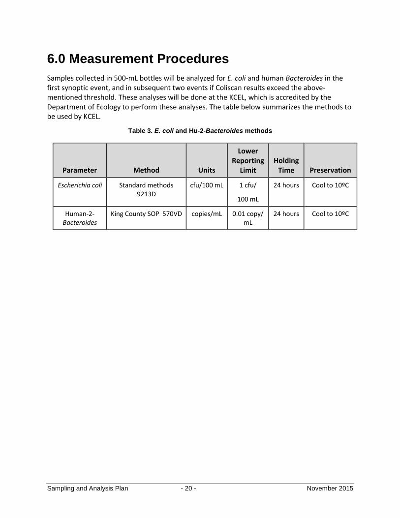
6.0 Measurement Procedures
Samples collected in 500-mL bottles will be analyzed for E. coli and human Bacteroides in the first synoptic event, and in subsequent two events if Coliscan results exceed the above-mentioned threshold. These analyses will be done at the KCEL, which is accredited by the Department of Ecology to perform these analyses. The table below summarizes the methods to be used by KCEL.
Table 3. E. coli and Hu-2-Bacteroides methods
Parameter Method Units
Lower Reporting
Limit Holding
Time Preservation
Escherichia coli Standard methods 9213D
cfu/100 mL 1 cfu/
100 mL
24 hours Cool to 10ºC
Human-2- Bacteroides
King County SOP 570VD copies/mL 0.01 copy/ mL
24 hours Cool to 10ºC
Sampling and Analysis Plan - 21 - November 2015
7.0 Quality Assurance/Quality Control Objectives
7.1 Data quality objectives
Data quality objectives (DQOs) reflect the overall degree of data quality or uncertainty considered acceptable during decision making. DQOs typically describe the quality of the data in terms of precision, accuracy (bias), representativeness, comparability, and completeness.
Precision is a measure of data scatter due to random error, and reflects the reproducibility of measurements under a given set of conditions. Precision is evaluated through duplicate field and laboratory samples.
Accuracy is a measure of differences between a parameter value and the true value due to systematic errors. Sources of error include the sampling process, field contamination, sample preservation, sample handling, sample matrix, laboratory preparation, and analysis techniques. The most common methods to assess for accuracy are spiked samples and various types of blanks.
Representativeness expresses the degree to which sample data accurately and precisely represent population characteristics– in this case, E. coli levels in the water leaving the County’s MS4. At a given site, representativeness is achieved by collecting a sufficient number of samples to be able to characterize E. coli levels at that site with some degree of confidence. In the basin as a whole, representativeness is achieved by sampling at locations that drain relatively large areas, so the sample data can be said to represent the MS4’s bacterial contribution to Bear Creek.
Comparability is a qualitative parameter expressing the confidence with which one data set can be compared to another. This goal will be achieved through use of standardized techniques to collect and analyze representative samples, along with standardized data validation and reporting procedures. All samples will be collected according to the sampling, handling, and analytic protocols established in this document.
Completeness is defined as the total number of samples for which acceptable analytical data are generated, compared to the total number of samples submitted for analysis. The goal for this project is 100 percent completeness. If 100 percent completeness is not achieved, the Project Manager and Assistant Project Manager will evaluate whether Study Objectives can still be met or if additional samples may need to be collected and analyzed.
Details regarding the procedures used to evaluate the precision and bias of lab sample collection, field measurements, and lab analyses are documented in the KCEL Standard Operating Procedures (SOPs) and Quality Assurance Manuals. Measurement quality objectives specific to the parameters to be reported for this project are summarized in the Quality Control sections of the applicable SOPs in section 7.2. It is expected that the quality objectives for this project will be achieved if the procedures in this document are followed and the frequency and
Sampling and Analysis Plan - 22 - November 2015
acceptance limits in the Quality Control sections of the applicable quality assurance documents are met.
7.2 Laboratory QA/QC: King County Environmental Laboratory
QA/QC for Escherichia coli
Routine QC analyses for Escherichia coli include both those procedures used to ensure the quality of each batch of media and containers and those procedures used to monitor method performance of each sample analysis batch or analysis session. A sample analysis batch should not exceed 20 samples of the same matrix that are all prepared and analyzed together, using the same reagents, media, and equipment. An analysis session consists of one or more batches done within a working day.
Each batch of media must be tested to confirm pH, sterility, and positive and negative performance characteristics. After washing and sterilization, each batch of containers used for the collection of samples must be evaluated for appropriate pH and sterility. Details on these procedures are available from KCEL.
Lab duplicates. Lab duplicates are prepared at a frequency of 5 percent per project. For MF, the acceptance limits are based on the precision criterion calculated from the duplicates of the previous 15 duplicate pairs (see Standard Methods, 22nd Edition. p. 9-18). These acceptance limits are updated automatically by the County’s Laboratory Information Management System (LIMS) whenever duplicate sample results are entered. If the 15 previous duplicate pairs are unavailable, a senior analyst and/or supervisor must evaluate the duplicate value.
Positive control. A positive control is prepared at a frequency of one per session. The positive control is a suspension of E. coli and analyzed through the complete procedure. The positive control should show an appropriate qualitative response for the test organism and should be identified as containing fecal coliforms or E. coli, as appropriate.
Negative control. A negative control is prepared at a frequency of one per session or 5 percent, whichever is more frequent. The negative control is a media streaked with a suspension of Proteus sp. or Enterobacter sp. and analyzed through the complete procedure. The negative control should show an appropriate qualitative response for the test organism and should not be identified as containing E. coli.
System controls. For the MF procedure, both a “pre” and a “post” filtration blank are prepared on the least specific media being used that day at a frequency of one set per session. The filtration blanks challenge the same batch of American Public Health Association (APHA) water (100 mL) used to dilute and analyze the samples. These system controls are considered acceptable if the target organism for the media is not detected. If the “pre” and “post” filtration blanks show positive results by the least-specific method, the controls must be evaluated by each of the more-specific methods.
Sampling and Analysis Plan - 23 - November 2015
Verification – Escherichia coli. Colonies identified as Escherichia coli are periodically confirmed by biochemical reactions in accordance with standard taxonomy. To ensure analysts’ accuracy, monthly verification tests are performed on 20 colonies picked from various samples being processed that month. Colonies should be picked within one hour of being placed on the urea soaked pad. The colonies are streaked for purity and then confirmed as E. coli with a standard biochemical screen; lactose positive on MacConkey agar, indole positive, and citrate negative. Results are archived in the QC data book.
Corrective actions. Corrective actions must be taken whenever a QC failure occurs. Unacceptable QC results within a batch or session of analyses require that all samples associated with those batches and/or session must be reviewed. A decision should be made as to if and how the samples should be qualified. A Data Anomaly form should be prepared to document the failure and describe how it was resolved, if possible, and how it could be avoided in the future.
QA/QC for Bacteroides
Routine QC analyses for MST qPCR testing include procedures used to monitor each sample filtration batch and each amplification run. A sample filtration batch should not exceed 20 samples of the same matrix that are all filtered together, using the same analysts, supplies, and equipment. Current acceptance limits are listed in the Data Review form shown in Appendix B of KCEL’s SOP for Bacteroides. These limits may change when each near-annual calibration curve is completed.
Duplicates. Lab duplicates are run on a minimum of 5 percent of samples per project.
Positive control. Three calibrator samples will be run with each amplification run. The positive control used is Bacteroides thetaiotaomicron ATTC # 29471.
Negative control. Two Non-Template Control (NTC) samples (nuclease-free water) are run with every amplification. Both the primer and probe sets for the target organism and the salmon DNA will be tested.
Endogenous control. Salmon Testes DNA (Skeeta) that codes for ribosomal RNA from chum salmon Oncorhyncus keta is run with every sample.
Method blanks. Method blanks will be run at a frequency of one per sample filtration batch. Results of the method blanks should be less than the LIMS MDL. If method blank fails, data will be re-evaluated.
Other QC procedures. DNA standards and standard curves will be run on a nearly annual basis.
Corrective Actions. An experienced analyst must review all QC failures. Corrective actions must be taken whenever a QC failure occurs. Unacceptable QC results within a filtration batch or amplification require that all samples associated with those batches and/or run must be reviewed. A failure of a positive control, NTC, or endogenous
Sampling and Analysis Plan - 24 - November 2015
control (skeeta) result for an individual sample should be reanalyzed on a separate run, following appropriate corrective action such as sample dilution. If a true QC failure occurs, a Data Anomaly form (DAF) should be prepared to document the failure, corrective actions taken, and the potential impact on data quality. The DAF should also describe how the anomaly could be avoided in the future.
7.3 Laboratory QA/QC: Stormwater Services
Stormwater Services will use the Coliscan Easygel© method as an in-house field screening tool to assess levels of E. coli in stormwater conveyance system samples. There is no regulatory limit for E. coli in Washington State receiving waters or stormwater. Stormwater Services’ in-house Coliscan work is not implied to be certified or warranted. As such, there is no formal QA/QC for Coliscan included in this SAP.
Alabama Water Watch (AWW) has created a quality assurance plan for the Coliscan Easygel© method that has been adopted by U.S. EPA Region 4 (AWW 1995). AWW’s QA methods will be incorporated into SWS’s practices to provide confidence that this screening tool is being well-utilized and results are representative of the true population of E. coli in aliquots obtained.
Key elements of SWS’s quality assurance protocols will be the following:
Use of positive and negative controls. SWS will be provided by KCEL with suspensions of Escherichia coli (as a positive control) and of Pseudomonas sp. (as a negative control) and will use these in consultation with KCEL to ensure that SWS’s incubators are working as intended.
Verification of Escherichia coli colonies. At the outset of the study, at a frequency of once every one or two synoptic sampling events, SWS will coordinate with KCEL for verification of Escherichia coli colonies. SWS will submit Coliscan petri dishes to KCEL and indicate between 10 and 20 colonies that SWS counted as E. coli, and KCEL will use the methods listed in section 7.2 of this SAP to verify that these colonies are indeed E. coli.
Side-by-side analyses with KCEL. Aliquots for Coliscan analysis will be pipetted directly from the same bottle to be submitted to KCEL. This is equivalent to splitting the sample. SWS’s Coliscan results will be compared to KCEL’s E. coli results to assess the Coliscan’s performance relative to standard methods.
Replicates. The pipetting of two separate aliquots for Coliscan analysis will provide some measure of the variability associated with subsampling or splitting samples.
Counting of colonies. At least 20 percent of E. coli plates will be counted by a second analyst. The second analyst will not know the name of the sampling site or the previous analyst’s count. Any plates for which there is a greater than 10 percent RPD between counts will be revisited and the discrepancies evaluated.
Sampling and Analysis Plan - 25 - November 2015
Consistent incubation temperature. All plates will be incubated at 95° Fahrenheit (± 2 °F) using temperature-controlled Little Giant Styrofoam chicken egg incubators manufactured by Hobovator and available from Incubators.com.
Proper sample handling. All laboratory procedures related to the Coliscan method will be undertaken with utmost care to avoid sample cross-contamination.
7.4 Field QA/QC: Stormwater Services
Field QA/QC on the part of Stormwater Services consists of the following:
Positive identification of sampling sites. Sampling locations are described in detail in the sampling site guides prepared for each site (see Appendix A). Sampling at the proper site will be ensured by the project manager by review of photos taken of the sampling site. Samples taken at the wrong location will be flagged or thrown out.
Field replicates and field blanks. These will be taken at 15 percent and 5 percent of all sites, respectively. Details are provided in section 5.5.
Proper sample collection and handling. All field procedures will be undertaken with utmost care to avoid sample cross-contamination. All samples will be kept on blue ice while they are in SWS’s custody, until their ultimate submittal to KCEL or incubation for in-house E. coli analysis at KSC.
Sampling and Analysis Plan - 26 - November 2015
8.0 Data Management Procedures
8.1 Data review, reporting, verification, and validation requirements
King County Environmental Laboratory
Data reported by KCEL, including field measurements, must pass a review process before final results are available to the client. A peer review process is used in which a second analyst or individual proficient at the method reviews the data set. The reviewer will complete a data review checklist that will document the completeness of the data package and assess whether any QC failures exist.
Once data review is complete and all data quality issues have been resolved or corrected, the status of the data in LIMS will be changed to “approved.” Once a data set has been approved, it is transferred to the Environmental Data System (EDS) where all historical LIMS data are maintained. Signatures or initials of the lab lead and reviewer(s) indicate formal approval of hardcopy data or reports (non-LIMS), typically on the review checklist. A copy of this approved checklist should be stored with the final hardcopy data package.
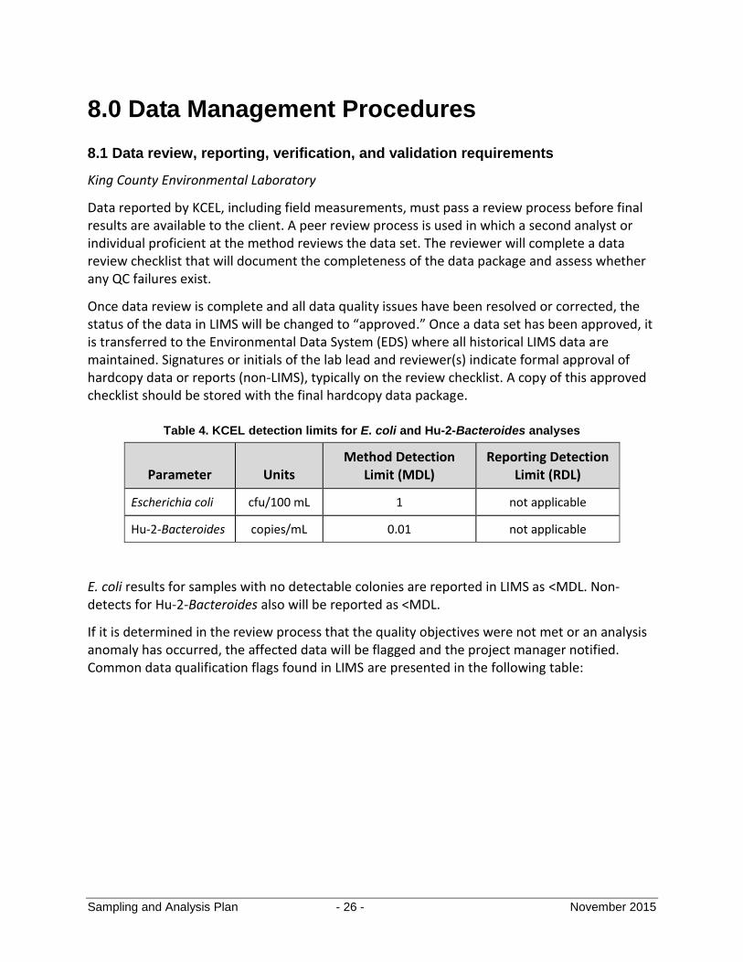
Table 4. KCEL detection limits for E. coli and Hu-2-Bacteroides analyses
Parameter Units Method Detection
Limit (MDL) Reporting Detection
Limit (RDL)
Escherichia coli cfu/100 mL 1 not applicable
Hu-2-Bacteroides copies/mL 0.01 not applicable
E. coli results for samples with no detectable colonies are reported in LIMS as <MDL. Non-detects for Hu-2-Bacteroides also will be reported as <MDL.
If it is determined in the review process that the quality objectives were not met or an analysis anomaly has occurred, the affected data will be flagged and the project manager notified. Common data qualification flags found in LIMS are presented in the following table:

Sampling and Analysis Plan - 27 - November 2015
Table 5. KCEL qualifier codes
Qualifier Description
H Indicates that a sample handling criterion was not met in some manner prior to analysis. The sample may have been compromised during the sampling procedure or may not comply with holding times, storage conditions, or preservation requirements. The qualifier will be applied to applicable analyses for a sample.
JU Indicates there are unknown variables in the qPCR test for that sample.
R Indicates that the data are judged unusable by the data reviewer. The qualifier is applied based on the professional judgment of the data reviewer rather than any specific set of QC parameters and is applied when the reviewer feels that the data may not or will not provide any useful information to the data user (other than as an approximate maximum or minimum value). This qualifier may or may not be analyte-specific.
TA Applied to a sample result when additional narrative information is available in the text field. The additional information may help to qualify the sample result but is not necessarily covered by any of the standard qualifiers.
C Applied to bacteria data when the sample analysis exhibits confluent growth of organisms. The value reported can be reliably used as an indicator of relative abundance, however, it cannot be used as an accurate count of the associated organism.
>##### Applied to bacteria data when the population count exceeds the procedural capacity to measure quantitatively. The number in the qualifier is the highest procedural count or concentration possible for the sample dilutions analyzed. A value is not entered into the numvalue field. The actual population count is at least as great as or greater than the value reported in the qualifier.
<MDL Applied when a target analyte is not detected or detected at a concentration less than the associated method detection limit (MDL). MDL is defined as the lowest concentration at which an analyte can be detected. The MDL is the lowest concentration at which a sample result will be reported.
J Applied to a parameter result when the reported value is an estimated value.
Stormwater Services
Written field observations and photos taken during sampling events will be checked by project management staff for accuracy and completeness.
Coliscan plate counts and photos will be peer-reviewed for accuracy, consistency, and completeness. Colors seen in photos of Coliscan plates will be normalized by using the same camera for taking photos and the same computer monitor for reviewing photos, as well as by taking a photo of a hue known to accurately represent an actual E. coli colony and viewing this on the designated computer monitor.

Sampling and Analysis Plan - 28 - November 2015
Field observations and in-house Coliscan plate count information will be included within or attached to program reports provided to relevant parties within and outside King County.
8.2 Data Storage
King County Environmental Laboratory
Once raw data has been generated by an analytical procedure or from field measurements, the data must be transformed into a format appropriate for the client. For microbiological parameters, numerical results are entered into LIMS where additional calculations may take place, such as conversion of instrumental concentrations to final sample results.
Data will not be distributed outside each lab unit or to clients until it has met the full definition of final data. “Final Data” is defined as approved data posted to the historical database (EDS) or is otherwise in its final reportable and stored format (if not a LIMS parameter). This implies the data has been appropriately peer reviewed, properly qualified, and is in its final format in terms of units and significant figures. Not only is final data assured of a higher level of quality through peer reviewing and qualification, but it will also match any future reports since it has come from the final storage location.
The standard method for clients to access final data is either through direct electronic access to LIMS (EDS database) or through hardcopy reports and/or electronic files provided by the Laboratory Project Manager or their equivalent. Direct client access to the EDS database is controlled by access privileges provided by the Information Systems and Data Analysis unit for individual clients. Data reporting via hardcopy through Laboratory Project Managers must follow the guidelines in King County Environmental Lab’s SOP# 11-03-001-001 (Project Report Review Guidelines) before being delivered to the client. Electronic files delivered to clients must also follow the King County Environmental Lab’s SOP # 08-01-001-000 (Guidelines for Delivering Electronic Lab Data to Customers).
All field and sampling records, custody documents, raw lab data, and summaries and narratives will be archived according to KCEL policy.
Stormwater Services
Written field observations and Coliscan plate counts will be transcribed into an Excel document or other software format. Relevant data for this project from KCEL will be imported from LIMS and included in SWS’s data tables. This information, along with field and Coliscan plate photos, will be stored on the SWS hard drive. Once compiled, all bacteria data (including both Coliscan data and data from KCEL) will be imported into SWS’s stormwater geodatabase, specifically the “StormEdit.STORMWATERMOBILEDBO.WQ_Sample” database table.
Sampling and Analysis Plan - 29 - November 2015
9.0 References
Alabama Water Watch, 1995. Quality Assurance Plan for Bacteriological Monitoring.
http://www.alabamawaterwatch.org/wp-content/uploads/sites/40/2015/02/QAQC-Bact-Plan_1999.pdf
King County 2005. Standard Operating Procedure for Escherichia coli in Environmental Waters by Membrane Filtration, SOP #522v0. King County Environmental Laboratory. Seattle, Washington.
King County 2006. Standard Operating Procedure for Field Measurements using an Attended Hydrolab, SOP #205v4. King County Environmental Laboratory. Seattle, Washington.
King County 2007. Standard Operating Procedure for Sampling Methods for Stream and River Water, SOP #214v3. King County Environmental Laboratory. Seattle, Washington.
King County 2012. Standard Operating Procedure for Bacteroides in Environmental Waters by Membrane Filtration and qPCR, SOP #570v0. King County Environmental Laboratory. Seattle, Washington.
King County 2012. King County Environmental Laboratory Quality Assurance Manual, Revision 24. King County Environmental Laboratory. Seattle, Washington.
Washington State Department of Ecology, 2008. Bear-Evans Watershed Fecal Coliform Bacteria TMDL Water Quality Improvement Report. https://fortress.wa.gov/ecy/publications/SummaryPages/0810026.html
Washington State Department of Ecology, 2011. Bear-Evans Watershed Temperature, Dissolved Oxygen, and Fecal Coliform Bacteria TMDL - Water Quality Implementation Plan. https://fortress.wa.gov/ecy/publications/summarypages/1110024.html
Washington State Department of Ecology, 2013. Phase I NPDES Municipal Permit. http://www.ecy.wa.gov/programs/wq/stormwater/municipal/phaseIpermit/phipermit.html
U.S. Environmental Protection Agency, 1992. Fecal Bacteria factsheet available on EPA website at http://water.epa.gov/type/rsl/monitoring/vms511.cfm
Sampling and Analysis Plan - 30 - November 2015
Appendix A: Sampling Site Guide
1
January 8, 2016 1 pm SWSS WQCU JED
King County Stormwater Services
Puyallup-White River FC TMDL Program 2015
Executive Summary
This document responds to Question 71 of the questionnaire from the Washington State
Department of Ecology regarding King County’s Phase I NPDES Municipal Stormwater Permit
Appendix 2 Puyallup-White Fecal Coliform Total Maximum Daily Load (FC TMDL)
implementation activities for 2015.
In 2015, King County Stormwater Services (SWSS) staff conducted bacterial source screening in
both the Boise and Jovita Creek municipal separate storm sewer (MS4) basins as required by
Appendix 2 of the NPDES permit for the Puyallup-White River FC TMDL. Work plans and
findings specific to each basin in 2015 are described in this document. For work performed prior
to 2015 and for background descriptions, previous documentation submitted to Ecology for
Annual Report 2014 can be reviewed. For efficiency and as a courtesy, this previous
documentation (of work performed in 2014) has been submitted to Ecology for 2015’s report.
At the time of this writing, no new illicit connections or illicit discharges of high bacteria have
definitely been identified in the Boise Creek or Jovita Creek MS4 basin areas. However,
Stormwater Services suspects that some high bacteria levels in the Boise Creek stormwater
system may be explained by the presence of cattle in this agricultural/pastoral basin, as well as
the agronomic application of manure to fields. Stormwater Services has no detailed information
regarding manure application. No specific parcels of concern regarding cattle fecal waste runoff
have been identified at time of this report.
Continued bacteria source screening work will be implemented in 2016 in Boise and Jovita
Creek MS4.
Regulatory Requirements
Under the Washington State Department of Ecology Phase I NPDES Municipal Stormwater Permit
effective August 1, 2013, in Appendix 2, Puyallup Watershed Fecal Coliform TMDL, King County is
required to perform the following:
Designate areas discharging via the MS4 to Boise Creek as high priority areas for illicit discharge
detection and elimination. Complete IDDE field screening for bacteria sources in 100 percent of
the MS4 subbasins, including rural subbasins, by February 2, 2016 and implement the schedules
and activities identified in S5.C.8 of the Phase I permit for response to any illicit discharges
found. Field screening must include activities for both the dry season (May through September)
and the wet season (October through April).
Inventory commercial animal handling areas (associated with Standard Industrial Code 074 and
075) in areas discharging via the MS4 to Boise Creek and conduct inspections of these areas as
2
January 8, 2016 1 pm SWSS WQCU JED
part of the Source Control program required in S5.C.7 of the Phase I permit. All qualifying
facilities must be inspected by August 1, 2016. The Permitted shall implement an ongoing
inspection program to re-inspect facilities or areas with bacteria source control problems every
three years. (County note: no such areas were found in the Boise Creek basin.)
Designate areas discharging via the MS4 to Jovita Creek as high priority areas for illicit discharge
detection and elimination field screening, and implement the schedules and activities identified in
S5.C.8 of the Phase I permit.
Introduction
This document updates work findings in bacteria source screening programs in Boise Creek and Jovita
Creek. King County Stormwater Services (SWSS) has undertaken these tasks as part of the Fecal
Coliform Total Maximum Daily Load (FC TMDL) program specific to the County’s MS4. Relevant
regulatory requirements are included in the following section.
For the following, the documents submitted for Annual Report 2014 may be consulted. These documents
were submitted concurrently with this write-up.
Field and Laboratory Methods
Project Trigger Levels for Bacteria and Nutrient Ions
Field Staff
Field Screening Techniques
BOISE CREEK BASIN
For the following, the documents submitted for Annual Report 2014 may be consulted. These documents
were submitted concurrently with this write-up.
Desktop Analyses, 2014
Investigation Site Selection, 2014
Field Investigation Tasks and Findings, 2014
Field Investigation Tasks and Findings, 2015
In 2015, the following work was performed:
Illicit discharge detection-type field reconnaissance and in-situ screening of the County MS4.
Additional MS4 sampling sites were added; the Boise sampling map (Figure 1) shows sampling
locations in the MS4.
Samples for bacterial analyses were obtained from MS4 locations in September, November and
December.
Samples were submitted to the following laboratories:
King County Environmental Lab, in Seattle, WA; and
Source Molecular, in Miami, FL.
3
January 8, 2016 1 pm SWSS WQCU JED
The illicit connections found in late 2014 (septic wastewater and laundry wash water discharging through
pipes called sample location BSE_107b into a County MS4 ditch) were removed in mid-2015. However,
elevated levels of bacteria were detected in a tile discharge pipe at this location in November 2015, so
there may be residual bacteria in the soil discharging from this site, or possibly some other bacterial
discharge mechanism. For this reason, this location near the former two illicit drainage pipes will
continue to be monitored and sampled, as feasible.
High levels of ruminant-specific Bacteroidales were found in MS4 water samples obtained in November
and December 2015. The November samples were submitted to the private lab Source Molecular for cow-
and cattle-waste specific DNA analyses, as specific sources of this ruminant waste were not known. This
is because in addition to cows and cattle in the Boise basin, there are also wild elk and deer present at
times, as well as domestic ruminants (alpacas, llamas, and possibly goats and sheep). Results from Source
Molecular for cattle and cow-specific waste markers indicate that there was likely some presence of
cattle/cow waste in the stormwater system at time of sampling (November 1, 2015). However, because of
a lack of spatially and temporally adequate data (e.g., a sufficient number of sample locations and sample
events), at the time of this report in January 2016 no specific parcels in the Boise Creek basin have been
identified as being definitive sources of cattle/cow waste runoff into the stormwater system. Further work
in 2016, including land use analysis and more sampling and analytical testing, may lead Stormwater
Services to identifying specific parcels as sources of cow/cattle waste affected runoff into the stormwater
system.

4
January 8, 2016 1 pm SWSS WQCU JED

5
January 8, 2016 1 pm SWSS WQCU JED
JOVITA CREEK BASIN
For the following, the documents submitted for Annual Report 2014 may be consulted. These documents
were submitted concurrently with this write-up.
Preliminary Basin Investigation
MS4 Basin Overview
Basin Map
MS4 Basin Boundaries
Land Use
Surface Water Drainage
Investigation Site Selection
Field Investigation Tasks and Findings, 2014
Agencies Helping to Identify & Eliminate Confirmed and Suspected Bacterial Sources
In 2015, more field reconnaissance in Jovita Basin MS4 was conducted. Locations with high bacterial
results from 2014 sampling and analysis were re-visited, with the goal of finding possible sources such as
failing septic systems or domestic animal waste mismanagement. No such sources were identified. Some
additional field screening and sampling will be conducted before the end of the permit requirement in
February 2016.
----------------------------------------End of Report-----------------------------------

Attachment 2015 Annual Report Question #69b:
Attach description of how the requirement from Question 69 was met.
NPDES s5 c10c Evaluation to direct education 1
Used results of measuring the understanding and adoption of targeted behaviors among at least one audience in at least one subject area to direct education and outreach resources and evaluate changes in adoption of targeted behaviors. (Required no later than February 2, 2016, S5.C.10.c). Attach description of how the requirement from Question 69 was met. Evaluation of behavior change for adapting approaches; King County Outreach Program Don’t Drip and Drive Vehicle Maintenance 2014-2015 The Don’t Drip and Drive program has engaged and empowered vehicle owners to find and fix vehicle leaks. Data from King County’s Environmental Behavior Index suggested that most vehicle owners would repair a vehicle leak within three months of discovery. Further research found that many vehicle owners are unaware of vehicle leaks. Pierce County received a Grant of Regional or Statewide Significance from the Department of Ecology in 2014 to implement Phase 2 of the Don’t Drip and Drive vehicle maintenance program. To help people find out whether their vehicle was leaking and help them get leaks fixed more quickly, the program included:
• Advertising and a website to make people aware of leaks and the impacts on Puget Sound and provide information about finding and fixing leaks.
• Partnerships with 102 auto repair shops around the region who provided a free leak inspection and up to $50 off of repairs.
• Free leak check events at public locations or large employers which let people know whether they had a leak and provide them with program resources.
• Free half-day auto leak repair workshops with education about vehicle systems, maintenance and a complete vehicle inspection for every attendee.
The program evaluated the effectiveness of each element and recommended improvements. In 2016, King County received a Grant of Regional or Statewide Significance on behalf of the Don’t Drip and Drive team for Phase 3 of the program. Phase 3 will include many of the recommended improvements and incorporate new elements to:
• Expand multimedia advertising using successful messaging strategy (Phase 2 included online ads only).
• Make website improvements, including online registration, reporting for participating repair shops and workshop registration.
• Advertise leak check events broadly and allowing people to self-select – targeting those who suspect they might have a leak rather than testing all of cars that use a parking area. This may allow us to reach more leakers.
• Continue repair shop partnerships and assign a staff person for repair shop support to improve implementation and reporting.
• Recruit new quick lube shops as partners; they do oil changes but not leak repairs. The quick lube shops will notify vehicle owners when they see evidence of a leak and provide them with program resources to help get the leak repaired.
• Include Spanish-language outreach and web information. • Expand vehicle leak workshops beyond King County for the first time. Workshops will likely be
held in Snohomish, Pierce and Thurston counties by establishing new partnerships with technical colleges in those areas.

NPDES s5 c10c Evaluation to direct education 2
Pierce County worked with a steering committee comprised of representatives from King and Snohomish counties, Ecology and Futurewise to plan, implement and evaluate the program on behalf of the STORM (Stormwater Outreach for Regional Municipalities) network. King and Pierce County, Ecology and Futurewise will continue to serve as key members of the steering committee for Phase 3. Program planning will take place through summer 2016 with a public launch in fall 2016. The program evaluation report will be finalized by June 2017. Program website is available at fixcarleaks.org; report appendices, evaluation and partner toolkit can be accessed at piercecountywa.org/dontdripanddrive.

Attachment 2015 Annual Report Question #67:
Attach description of public education and outreach efforts conducted per
S5.C.10.

STORMWATER MANAGEMENT PROGRAM
Education and outreach summary - Water & Land Resources Division 2014 DRAFT
Permit citation S5.C.10 a.i.1 a.i.1
a.i.1
a.ii.1
a.i.1
a.i.2 a.i.1 a.i.2 a.i.2 a.ii.1 a.ii.1a.i.2a.i.2 a.i.2 a.i.2 a.i.2 a.i.2 a.i.2 b c
Pu
blic
: Mai
nst
ream
Pu
blic
: Mu
ltic
ult
ura
l
Sch
oo
l Age
Ch
ildre
n
Bu
sin
esse
s
Ho
me/
Mo
bile
-bas
ed B
usi
nes
ses
Engi
nee
rs
Co
ntr
acto
rs
Dev
elo
per
s
Pla
nn
ers,
Lan
d U
se
Pro
per
ty M
anag
ers/
Ow
ner
s
Lan
dsc
aper
s, r
esid
ents
Gen
eral
imp
acts
of
sto
rmw
ater
on
surf
ace
wat
ers
Imp
ervi
ou
s su
rfac
es im
pac
ts
Illic
it d
isch
arge
pre
ven
tio
n, i
mp
acts
and
re
po
rtin
g
Low
Imp
act
Dev
elo
pm
ent,
LID
Bes
t
Pra
ctic
es
Envi
ron
men
tal s
tew
ard
ship
Tech
nic
al s
tan
dar
ds
for
site
/ero
sio
n
con
tro
l
Sto
rmw
ater
tre
atm
ent,
flo
w c
on
tro
l
pra
ctic
es/f
acili
ties
Use
/sto
rage
of
auto
mo
tive
chem
ical
s,
haz
ard
ou
s cl
ean
ers
and
mat
eri
als,
carw
ash
so
aps
Equ
ipm
ent
mai
nte
nan
ce
Yard
car
e te
chn
iqu
esU
se a
nd
sto
rage
of
pes
tici
des
,
fert
ilize
rs,
ho
use
ho
ld c
hem
ical
s
Car
pet
cle
anin
g, a
uto
re
pai
r an
d
mai
nte
nan
ce
Veh
icle
, eq
uip
men
t, a
nd
ho
me/
bu
ildin
g m
ain
ten
ance
An
imal
was
te
Sto
rmw
ater
fac
ility
mai
nte
nan
ce
Du
mp
ste
r an
d t
rash
co
mp
acto
r
mai
nte
nan
ce
Mea
sure
beh
avio
r ch
ange
an
d a
dap
t
Trac
k p
rogr
am m
easu
res
and
rep
ort
ing
Program name
Program
Contact Program Description
Stormwater
Services Wes Chin
SWS Asset Management Unit: inspections,
repairs, projects, illicit discharges, and
maintenance of stormwater system. x x x x x x x x x x x x x x x x x x
Stormwater
Services Jeanne Dorn Illicit discharges and TMDLs x x x x x x x x x
Business outreach Cynthia Hickey
Businesses are visited and inspected for safe
chemical use and storage, and stormwater
facilities function in coordination with other
business outreach agencies. x x x x x x x x x x x x x x x x x x x x x
Business outreachSue Hamilton
Provide technical support and incentives to SQG
businesses to safely manage hazardous materials
and wastes. x x x x x x x x x x x x x x x x x x x x x
Livestock Program Rick Reinlasoder
Technical and financial assistance to minimize
environmental impacts of livestock, manure and
farming activities on water quality. The livestock
related work is guided by the Livestock
Management Ordinance (King County Code x x x x x x x x x x x x x
Public Benefit
Rating System;
Timberland
Current Use
Taxation Program
Bill Bernstein
Incentive for landowners to exceed code
requirements for retaining open space and
managing properties for environmental benefit.
Program attracts new participants to farm
management, forest stewardship and resource
restoration planning. x x x x x x
a.i.1; a.i.2; a.ii.1; a.ii.2; b
Audience Topics
1
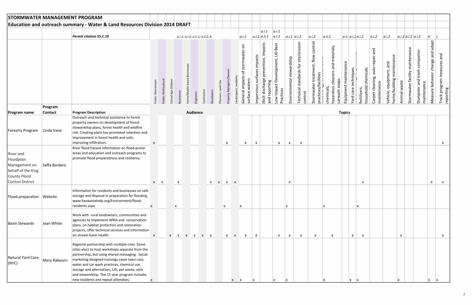
STORMWATER MANAGEMENT PROGRAM
Education and outreach summary - Water & Land Resources Division 2014 DRAFT
Permit citation S5.C.10 a.i.1 a.i.1
a.i.1
a.ii.1
a.i.1
a.i.2 a.i.1 a.i.2 a.i.2 a.ii.1 a.ii.1a.i.2a.i.2 a.i.2 a.i.2 a.i.2 a.i.2 a.i.2 b c
Pu
blic
: Mai
nst
ream
Pu
blic
: Mu
ltic
ult
ura
l
Sch
oo
l Age
Ch
ildre
n
Bu
sin
esse
s
Ho
me/
Mo
bile
-bas
ed B
usi
nes
ses
Engi
nee
rs
Co
ntr
acto
rs
Dev
elo
per
s
Pla
nn
ers,
Lan
d U
se
Pro
per
ty M
anag
ers/
Ow
ner
s
Lan
dsc
aper
s, r
esid
ents
Gen
eral
imp
acts
of
sto
rmw
ater
on
surf
ace
wat
ers
Imp
ervi
ou
s su
rfac
es im
pac
ts
Illic
it d
isch
arge
pre
ven
tio
n, i
mp
acts
and
re
po
rtin
g
Low
Imp
act
Dev
elo
pm
ent,
LID
Bes
t
Pra
ctic
es
Envi
ron
men
tal s
tew
ard
ship
Tech
nic
al s
tan
dar
ds
for
site
/ero
sio
n
con
tro
l
Sto
rmw
ater
tre
atm
ent,
flo
w c
on
tro
l
pra
ctic
es/f
acili
ties
Use
/sto
rage
of
auto
mo
tive
chem
ical
s,
haz
ard
ou
s cl
ean
ers
and
mat
eri
als,
carw
ash
so
aps
Equ
ipm
ent
mai
nte
nan
ce
Yard
car
e te
chn
iqu
esU
se a
nd
sto
rage
of
pes
tici
des
,
fert
ilize
rs,
ho
use
ho
ld c
hem
ical
s
Car
pet
cle
anin
g, a
uto
re
pai
r an
d
mai
nte
nan
ce
Veh
icle
, eq
uip
men
t, a
nd
ho
me/
bu
ildin
g m
ain
ten
ance
An
imal
was
te
Sto
rmw
ater
fac
ility
mai
nte
nan
ce
Du
mp
ste
r an
d t
rash
co
mp
acto
r
mai
nte
nan
ce
Mea
sure
beh
avio
r ch
ange
an
d a
dap
t
Trac
k p
rogr
am m
easu
res
and
rep
ort
ing
Program name
Program
Contact Program Description
a.i.1; a.i.2; a.ii.1; a.ii.2; b
Audience Topics
Forestry Program Linda Vane
Outreach and technical assistance to forest
property owners on development of forest
stewardship plans, forest health and wildfire
risk. Creating plans has promoted retention and
improvement in forest health and soils,
improving infiltration. x x x x x x x x
River and
Floodplain
Management on
behalf of the King
County Flood
Control District
Saffa Bardaro
River flood hazard information on flood-prone
areas and education and outreach programs to
promote flood preparedness and resiliency.
x x x x x x x x x x x
Flood preparation Website
Information for residents and businesses on safe
storage and disposal in preparation for flooding.
www.hazwastehelp.org/Environment/flood-
residents.aspx x x x x x x x
Basin Stewards Jean White
Work with rural landowners, communities and
agencies to implement WRIA and conservation
plans, on habitat protection and restoration
projects, offer technical services and information
on stream basin health. x x x x x x x x x x x x x x x x x x x x
Natural Yard Care
(NYC) Mary Rabourn
Regional partnership with multiple cites. Some
cities elect to host workshops separate from the
partnership, but using shared messaging. Social
marketing designed trainings cover lawn care,
water and car wash practices, chemical use,
storage and alternatives, LID, pet waste, soils
and stewardship. The 15 year program includes
new residents and repeat attendees. x x x x x x x x x x x x
2
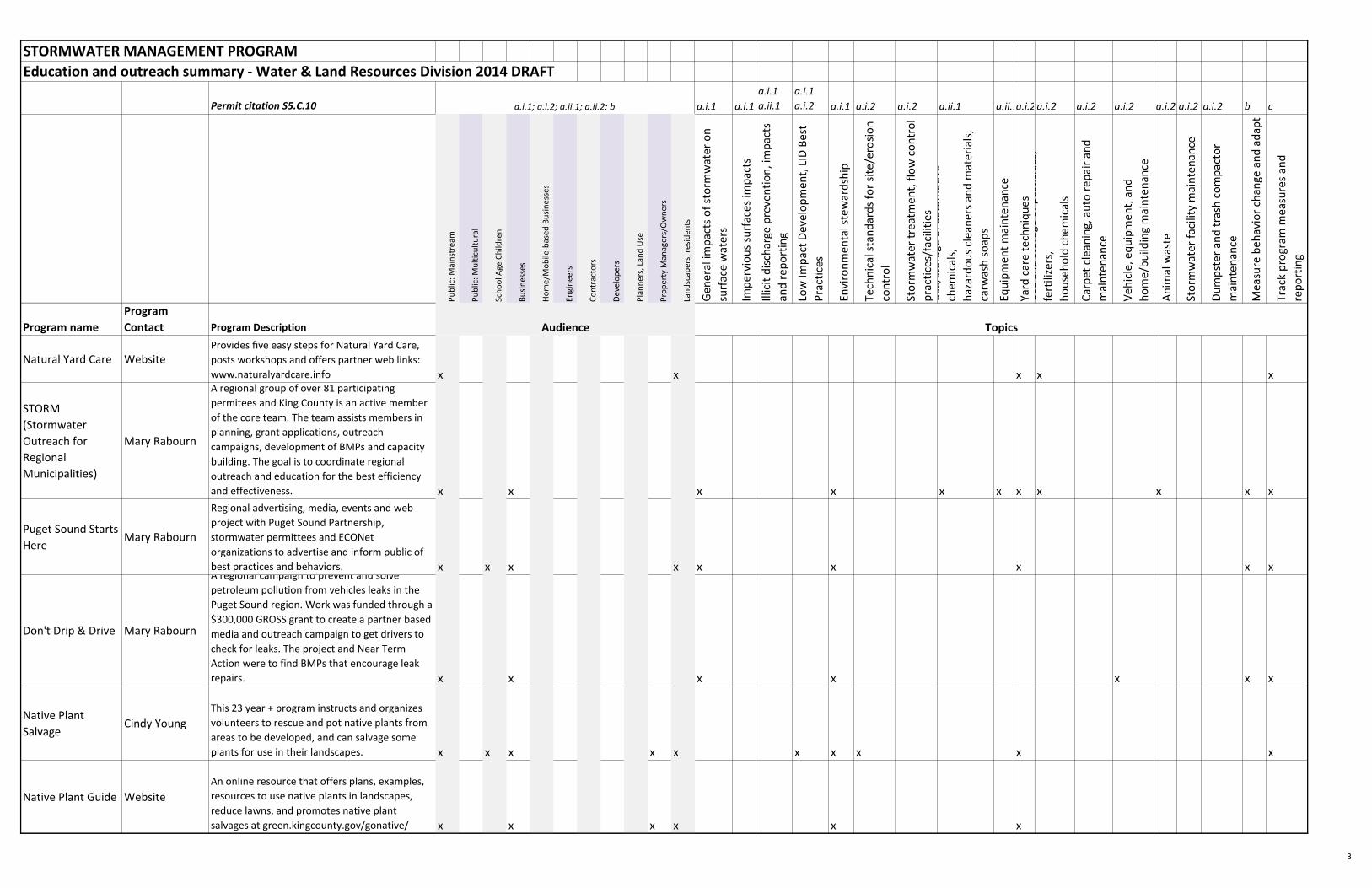
STORMWATER MANAGEMENT PROGRAM
Education and outreach summary - Water & Land Resources Division 2014 DRAFT
Permit citation S5.C.10 a.i.1 a.i.1
a.i.1
a.ii.1
a.i.1
a.i.2 a.i.1 a.i.2 a.i.2 a.ii.1 a.ii.1a.i.2a.i.2 a.i.2 a.i.2 a.i.2 a.i.2 a.i.2 b c
Pu
blic
: Mai
nst
ream
Pu
blic
: Mu
ltic
ult
ura
l
Sch
oo
l Age
Ch
ildre
n
Bu
sin
esse
s
Ho
me/
Mo
bile
-bas
ed B
usi
nes
ses
Engi
nee
rs
Co
ntr
acto
rs
Dev
elo
per
s
Pla
nn
ers,
Lan
d U
se
Pro
per
ty M
anag
ers/
Ow
ner
s
Lan
dsc
aper
s, r
esid
ents
Gen
eral
imp
acts
of
sto
rmw
ater
on
surf
ace
wat
ers
Imp
ervi
ou
s su
rfac
es im
pac
ts
Illic
it d
isch
arge
pre
ven
tio
n, i
mp
acts
and
re
po
rtin
g
Low
Imp
act
Dev
elo
pm
ent,
LID
Bes
t
Pra
ctic
es
Envi
ron
men
tal s
tew
ard
ship
Tech
nic
al s
tan
dar
ds
for
site
/ero
sio
n
con
tro
l
Sto
rmw
ater
tre
atm
ent,
flo
w c
on
tro
l
pra
ctic
es/f
acili
ties
Use
/sto
rage
of
auto
mo
tive
chem
ical
s,
haz
ard
ou
s cl
ean
ers
and
mat
eri
als,
carw
ash
so
aps
Equ
ipm
ent
mai
nte
nan
ce
Yard
car
e te
chn
iqu
esU
se a
nd
sto
rage
of
pes
tici
des
,
fert
ilize
rs,
ho
use
ho
ld c
hem
ical
s
Car
pet
cle
anin
g, a
uto
re
pai
r an
d
mai
nte
nan
ce
Veh
icle
, eq
uip
men
t, a
nd
ho
me/
bu
ildin
g m
ain
ten
ance
An
imal
was
te
Sto
rmw
ater
fac
ility
mai
nte
nan
ce
Du
mp
ste
r an
d t
rash
co
mp
acto
r
mai
nte
nan
ce
Mea
sure
beh
avio
r ch
ange
an
d a
dap
t
Trac
k p
rogr
am m
easu
res
and
rep
ort
ing
Program name
Program
Contact Program Description
a.i.1; a.i.2; a.ii.1; a.ii.2; b
Audience Topics
Natural Yard Care WebsiteProvides five easy steps for Natural Yard Care,
posts workshops and offers partner web links:
www.naturalyardcare.info x x x x x
STORM
(Stormwater
Outreach for
Regional
Municipalities)
Mary Rabourn
A regional group of over 81 participating
permitees and King County is an active member
of the core team. The team assists members in
planning, grant applications, outreach
campaigns, development of BMPs and capacity
building. The goal is to coordinate regional
outreach and education for the best efficiency
and effectiveness. x x x x x x x x x x x
Puget Sound Starts
HereMary Rabourn
Regional advertising, media, events and web
project with Puget Sound Partnership,
stormwater permittees and ECONet
organizations to advertise and inform public of
best practices and behaviors. x x x x x x x x x
Don't Drip & Drive Mary Rabourn
A regional campaign to prevent and solve
petroleum pollution from vehicles leaks in the
Puget Sound region. Work was funded through a
$300,000 GROSS grant to create a partner based
media and outreach campaign to get drivers to
check for leaks. The project and Near Term
Action were to find BMPs that encourage leak
repairs. x x x x x x x
Native Plant
SalvageCindy Young
This 23 year + program instructs and organizes
volunteers to rescue and pot native plants from
areas to be developed, and can salvage some
plants for use in their landscapes. x x x x x x x x x x
Native Plant Guide Website
An online resource that offers plans, examples,
resources to use native plants in landscapes,
reduce lawns, and promotes native plant
salvages at green.kingcounty.gov/gonative/ x x x x x x
3
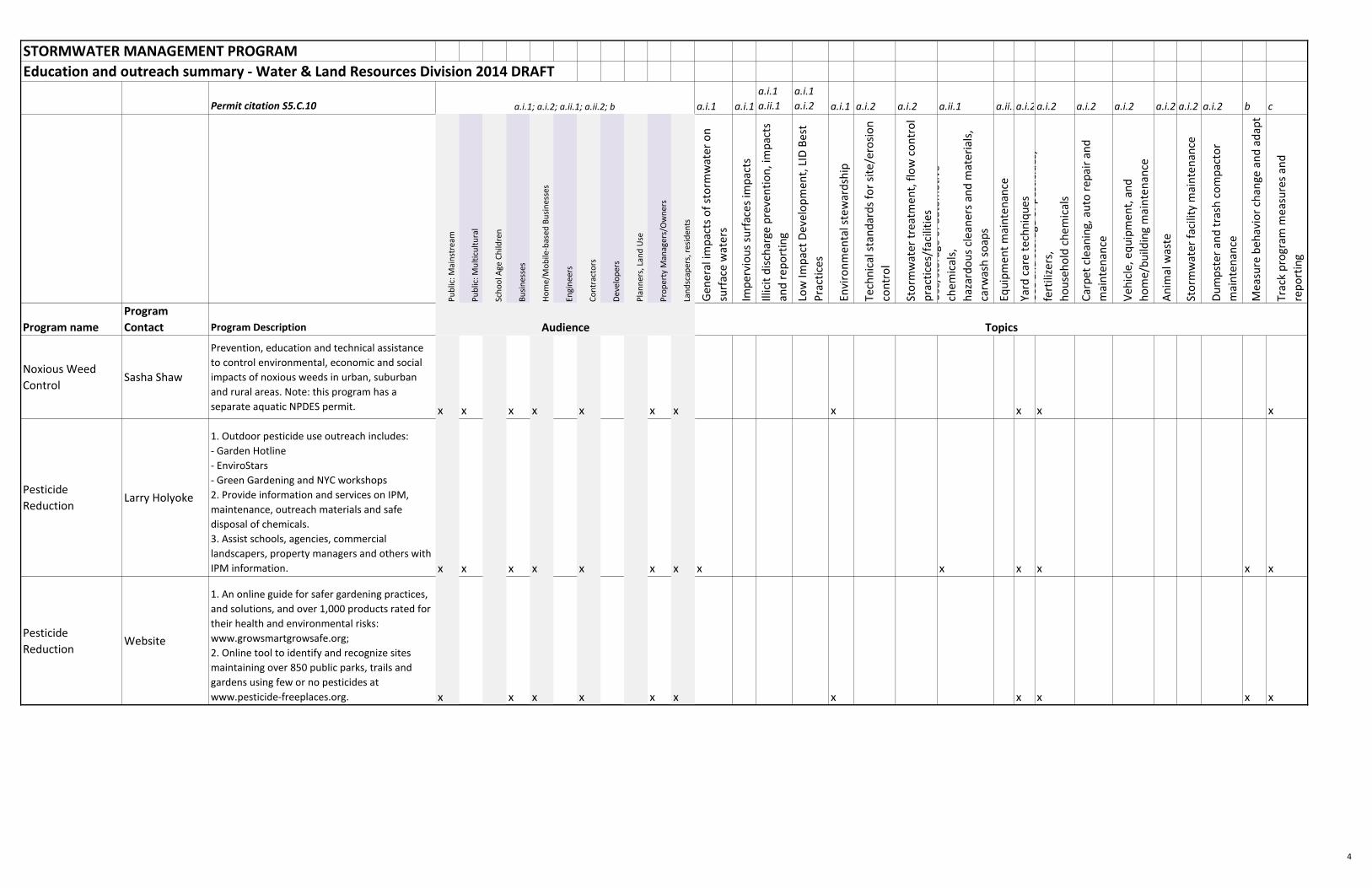
STORMWATER MANAGEMENT PROGRAM
Education and outreach summary - Water & Land Resources Division 2014 DRAFT
Permit citation S5.C.10 a.i.1 a.i.1
a.i.1
a.ii.1
a.i.1
a.i.2 a.i.1 a.i.2 a.i.2 a.ii.1 a.ii.1a.i.2a.i.2 a.i.2 a.i.2 a.i.2 a.i.2 a.i.2 b c
Pu
blic
: Mai
nst
ream
Pu
blic
: Mu
ltic
ult
ura
l
Sch
oo
l Age
Ch
ildre
n
Bu
sin
esse
s
Ho
me/
Mo
bile
-bas
ed B
usi
nes
ses
Engi
nee
rs
Co
ntr
acto
rs
Dev
elo
per
s
Pla
nn
ers,
Lan
d U
se
Pro
per
ty M
anag
ers/
Ow
ner
s
Lan
dsc
aper
s, r
esid
ents
Gen
eral
imp
acts
of
sto
rmw
ater
on
surf
ace
wat
ers
Imp
ervi
ou
s su
rfac
es im
pac
ts
Illic
it d
isch
arge
pre
ven
tio
n, i
mp
acts
and
re
po
rtin
g
Low
Imp
act
Dev
elo
pm
ent,
LID
Bes
t
Pra
ctic
es
Envi
ron
men
tal s
tew
ard
ship
Tech
nic
al s
tan
dar
ds
for
site
/ero
sio
n
con
tro
l
Sto
rmw
ater
tre
atm
ent,
flo
w c
on
tro
l
pra
ctic
es/f
acili
ties
Use
/sto
rage
of
auto
mo
tive
chem
ical
s,
haz
ard
ou
s cl
ean
ers
and
mat
eri
als,
carw
ash
so
aps
Equ
ipm
ent
mai
nte
nan
ce
Yard
car
e te
chn
iqu
esU
se a
nd
sto
rage
of
pes
tici
des
,
fert
ilize
rs,
ho
use
ho
ld c
hem
ical
s
Car
pet
cle
anin
g, a
uto
re
pai
r an
d
mai
nte
nan
ce
Veh
icle
, eq
uip
men
t, a
nd
ho
me/
bu
ildin
g m
ain
ten
ance
An
imal
was
te
Sto
rmw
ater
fac
ility
mai
nte
nan
ce
Du
mp
ste
r an
d t
rash
co
mp
acto
r
mai
nte
nan
ce
Mea
sure
beh
avio
r ch
ange
an
d a
dap
t
Trac
k p
rogr
am m
easu
res
and
rep
ort
ing
Program name
Program
Contact Program Description
a.i.1; a.i.2; a.ii.1; a.ii.2; b
Audience Topics
Noxious Weed
Control Sasha Shaw
Prevention, education and technical assistance
to control environmental, economic and social
impacts of noxious weeds in urban, suburban
and rural areas. Note: this program has a
separate aquatic NPDES permit. x x x x x x x x x x x
Pesticide
ReductionLarry Holyoke
1. Outdoor pesticide use outreach includes:
- Garden Hotline
- EnviroStars
- Green Gardening and NYC workshops
2. Provide information and services on IPM,
maintenance, outreach materials and safe
disposal of chemicals.
3. Assist schools, agencies, commercial
landscapers, property managers and others with
IPM information. x x x x x x x x x x x x x
Pesticide
ReductionWebsite
1. An online guide for safer gardening practices,
and solutions, and over 1,000 products rated for
their health and environmental risks:
www.growsmartgrowsafe.org;
2. Online tool to identify and recognize sites
maintaining over 850 public parks, trails and
gardens using few or no pesticides at
www.pesticide-freeplaces.org. x x x x x x x x x x x
4
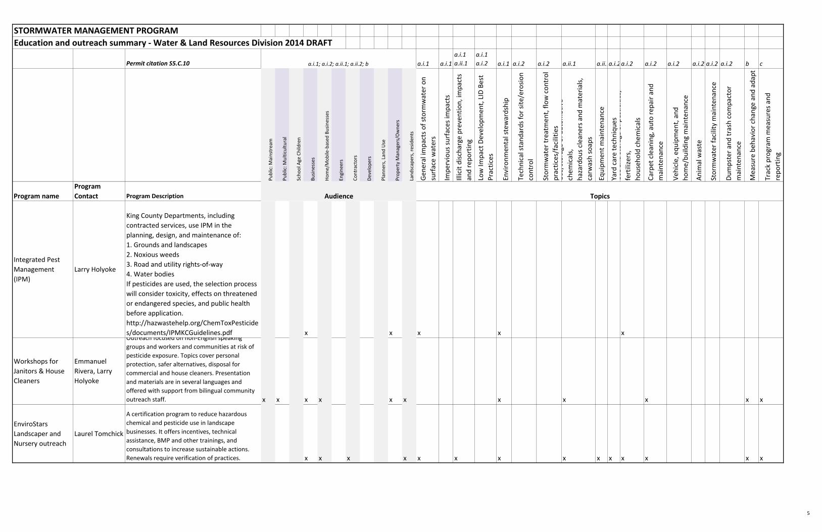
STORMWATER MANAGEMENT PROGRAM
Education and outreach summary - Water & Land Resources Division 2014 DRAFT
Permit citation S5.C.10 a.i.1 a.i.1
a.i.1
a.ii.1
a.i.1
a.i.2 a.i.1 a.i.2 a.i.2 a.ii.1 a.ii.1a.i.2a.i.2 a.i.2 a.i.2 a.i.2 a.i.2 a.i.2 b c
Pu
blic
: Mai
nst
ream
Pu
blic
: Mu
ltic
ult
ura
l
Sch
oo
l Age
Ch
ildre
n
Bu
sin
esse
s
Ho
me/
Mo
bile
-bas
ed B
usi
nes
ses
Engi
nee
rs
Co
ntr
acto
rs
Dev
elo
per
s
Pla
nn
ers,
Lan
d U
se
Pro
per
ty M
anag
ers/
Ow
ner
s
Lan
dsc
aper
s, r
esid
ents
Gen
eral
imp
acts
of
sto
rmw
ater
on
surf
ace
wat
ers
Imp
ervi
ou
s su
rfac
es im
pac
ts
Illic
it d
isch
arge
pre
ven
tio
n, i
mp
acts
and
re
po
rtin
g
Low
Imp
act
Dev
elo
pm
ent,
LID
Bes
t
Pra
ctic
es
Envi
ron
men
tal s
tew
ard
ship
Tech
nic
al s
tan
dar
ds
for
site
/ero
sio
n
con
tro
l
Sto
rmw
ater
tre
atm
ent,
flo
w c
on
tro
l
pra
ctic
es/f
acili
ties
Use
/sto
rage
of
auto
mo
tive
chem
ical
s,
haz
ard
ou
s cl
ean
ers
and
mat
eri
als,
carw
ash
so
aps
Equ
ipm
ent
mai
nte
nan
ce
Yard
car
e te
chn
iqu
esU
se a
nd
sto
rage
of
pes
tici
des
,
fert
ilize
rs,
ho
use
ho
ld c
hem
ical
s
Car
pet
cle
anin
g, a
uto
re
pai
r an
d
mai
nte
nan
ce
Veh
icle
, eq
uip
men
t, a
nd
ho
me/
bu
ildin
g m
ain
ten
ance
An
imal
was
te
Sto
rmw
ater
fac
ility
mai
nte
nan
ce
Du
mp
ste
r an
d t
rash
co
mp
acto
r
mai
nte
nan
ce
Mea
sure
beh
avio
r ch
ange
an
d a
dap
t
Trac
k p
rogr
am m
easu
res
and
rep
ort
ing
Program name
Program
Contact Program Description
a.i.1; a.i.2; a.ii.1; a.ii.2; b
Audience Topics
Integrated Pest
Management
(IPM)
Larry Holyoke
King County Departments, including
contracted services, use IPM in the
planning, design, and maintenance of:
1. Grounds and landscapes
2. Noxious weeds
3. Road and utility rights-of-way
4. Water bodies
If pesticides are used, the selection process
will consider toxicity, effects on threatened
or endangered species, and public health
before application.
http://hazwastehelp.org/ChemToxPesticide
s/documents/IPMKCGuidelines.pdf x x x x x
Workshops for
Janitors & House
Cleaners
Emmanuel
Rivera, Larry
Holyoke
Outreach focused on non-English speaking
groups and workers and communities at risk of
pesticide exposure. Topics cover personal
protection, safer alternatives, disposal for
commercial and house cleaners. Presentation
and materials are in several languages and
offered with support from bilingual community
outreach staff. x x x x x x x x x x x
EnviroStars
Landscaper and
Nursery outreach
Laurel Tomchick
A certification program to reduce hazardous
chemical and pesticide use in landscape
businesses. It offers incentives, technical
assistance, BMP and other trainings, and
consultations to increase sustainable actions.
Renewals require verification of practices. x x x x x x x x x x x x x x
5
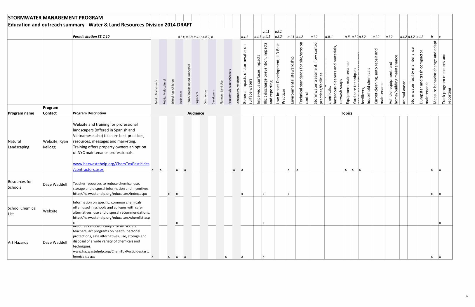
STORMWATER MANAGEMENT PROGRAM
Education and outreach summary - Water & Land Resources Division 2014 DRAFT
Permit citation S5.C.10 a.i.1 a.i.1
a.i.1
a.ii.1
a.i.1
a.i.2 a.i.1 a.i.2 a.i.2 a.ii.1 a.ii.1a.i.2a.i.2 a.i.2 a.i.2 a.i.2 a.i.2 a.i.2 b c
Pu
blic
: Mai
nst
ream
Pu
blic
: Mu
ltic
ult
ura
l
Sch
oo
l Age
Ch
ildre
n
Bu
sin
esse
s
Ho
me/
Mo
bile
-bas
ed B
usi
nes
ses
Engi
nee
rs
Co
ntr
acto
rs
Dev
elo
per
s
Pla
nn
ers,
Lan
d U
se
Pro
per
ty M
anag
ers/
Ow
ner
s
Lan
dsc
aper
s, r
esid
ents
Gen
eral
imp
acts
of
sto
rmw
ater
on
surf
ace
wat
ers
Imp
ervi
ou
s su
rfac
es im
pac
ts
Illic
it d
isch
arge
pre
ven
tio
n, i
mp
acts
and
re
po
rtin
g
Low
Imp
act
Dev
elo
pm
ent,
LID
Bes
t
Pra
ctic
es
Envi
ron
men
tal s
tew
ard
ship
Tech
nic
al s
tan
dar
ds
for
site
/ero
sio
n
con
tro
l
Sto
rmw
ater
tre
atm
ent,
flo
w c
on
tro
l
pra
ctic
es/f
acili
ties
Use
/sto
rage
of
auto
mo
tive
chem
ical
s,
haz
ard
ou
s cl
ean
ers
and
mat
eri
als,
carw
ash
so
aps
Equ
ipm
ent
mai
nte
nan
ce
Yard
car
e te
chn
iqu
esU
se a
nd
sto
rage
of
pes
tici
des
,
fert
ilize
rs,
ho
use
ho
ld c
hem
ical
s
Car
pet
cle
anin
g, a
uto
re
pai
r an
d
mai
nte
nan
ce
Veh
icle
, eq
uip
men
t, a
nd
ho
me/
bu
ildin
g m
ain
ten
ance
An
imal
was
te
Sto
rmw
ater
fac
ility
mai
nte
nan
ce
Du
mp
ste
r an
d t
rash
co
mp
acto
r
mai
nte
nan
ce
Mea
sure
beh
avio
r ch
ange
an
d a
dap
t
Trac
k p
rogr
am m
easu
res
and
rep
ort
ing
Program name
Program
Contact Program Description
a.i.1; a.i.2; a.ii.1; a.ii.2; b
Audience Topics
Natural
Landscaping
Website, Ryan
Kellogg
Website and training for professional
landscapers (offered in Spanish and
Vietnamese also) to share best practices,
resources, messages and marketing.
Training offers property owners an option
of NYC maintenance professionals.
www.hazwastehelp.org/ChemToxPesticides
/contractors.aspx x x x x x x x x x x x x x
Resources for
SchoolsDave Waddell Teacher resources to reduce chemical use,
storage and disposal information and incentives.
http://hazwastehelp.org/educators/index.aspx x x x x x x x
School Chemical
List Website
Information on specific, common chemicals
often used in schools and colleges with safer
alternatives, use and disposal recommendations.
http://hazwastehelp.org/educators/chemlist.asp
x x x x
Art Hazards Dave Waddell
Resources and workshops for artists, art
teachers, art programs on health, personal
protections, safe alternatives, use, storage and
disposal of a wide variety of chemicals and
techniques.
www.hazwastehelp.org/ChemToxPesticides/artc
hemicals.aspx x x x x x x x x x
6

Attachment 2015 Annual Report Question #62e:
Attach documentation of alternative catch basin inspection approach, if used
(S5.C.9.d.i.(1), (2), or (3)).
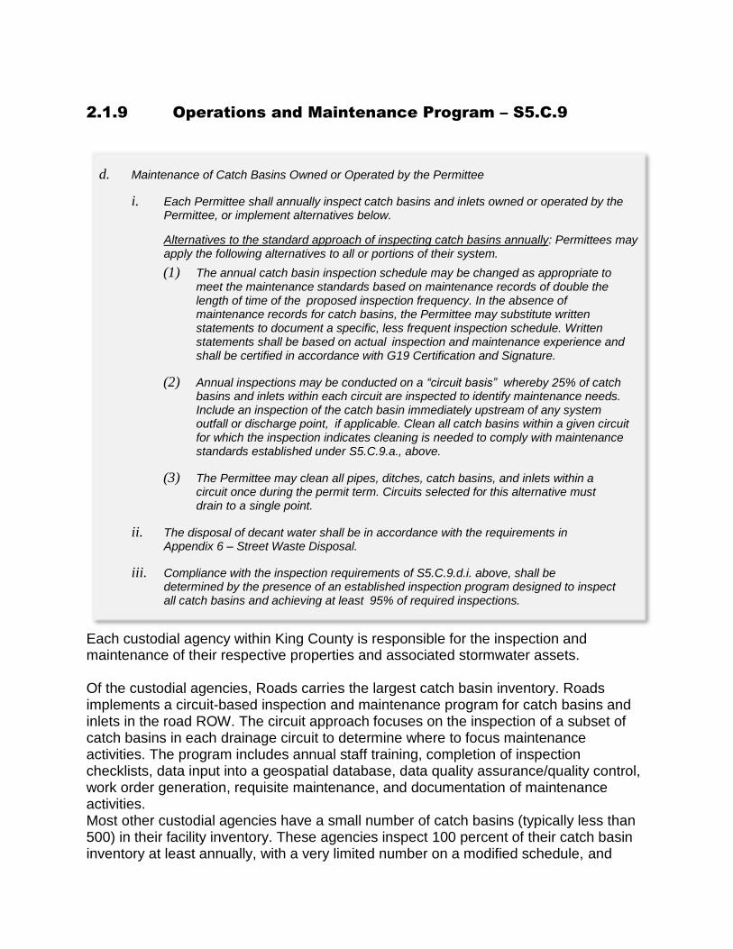
2.1.9 Operations and Maintenance Program – S5.C.9
Each custodial agency within King County is responsible for the inspection and maintenance of their respective properties and associated stormwater assets. Of the custodial agencies, Roads carries the largest catch basin inventory. Roads implements a circuit-based inspection and maintenance program for catch basins and inlets in the road ROW. The circuit approach focuses on the inspection of a subset of catch basins in each drainage circuit to determine where to focus maintenance activities. The program includes annual staff training, completion of inspection checklists, data input into a geospatial database, data quality assurance/quality control, work order generation, requisite maintenance, and documentation of maintenance activities. Most other custodial agencies have a small number of catch basins (typically less than 500) in their facility inventory. These agencies inspect 100 percent of their catch basin inventory at least annually, with a very limited number on a modified schedule, and
d. Maintenance of Catch Basins Owned or Operated by the Permittee
i. Each Permittee shall annually inspect catch basins and inlets owned or operated by the Permittee, or implement alternatives below.
Alternatives to the standard approach of inspecting catch basins annually: Permittees may apply the following alternatives to all or portions of their system.
(1) The annual catch basin inspection schedule may be changed as appropriate to meet the maintenance standards based on maintenance records of double the length of time of the proposed inspection frequency. In the absence of maintenance records for catch basins, the Permittee may substitute written statements to document a specific, less frequent inspection schedule. Written statements shall be based on actual inspection and maintenance experience and shall be certified in accordance with G19 Certification and Signature.
(2) Annual inspections may be conducted on a “circuit basis” whereby 25% of catch basins and inlets within each circuit are inspected to identify maintenance needs. Include an inspection of the catch basin immediately upstream of any system outfall or discharge point, if applicable. Clean all catch basins within a given circuit for which the inspection indicates cleaning is needed to comply with maintenance standards established under S5.C.9.a., above.
(3) The Permittee may clean all pipes, ditches, catch basins, and inlets within a circuit once during the permit term. Circuits selected for this alternative must drain to a single point.
ii. The disposal of decant water shall be in accordance with the requirements in Appendix 6 – Street Waste Disposal.
iii. Compliance with the inspection requirements of S5.C.9.d.i. above, shall be determined by the presence of an established inspection program designed to inspect all catch basins and achieving at least 95% of required inspections.
conduct maintenance on those that fail to meet the maintenance standards found in the SWDM. These agencies include SWD, WTD, Transit, Parks, and FMD. Roads operates a regional stormwater decant station in Renton and temporary decant stations at three other maintenance facilities run by Roads. These decant stations are a key element in the disposal of stormwater removed from the County’s MS4 during catch basin cleaning activities. All stormwater accepted at Roads’ decant stations is disposed of through the sanitary sewer. The KCIA has implemented an alternative approach due to several airport operation challenges, which is in accordance with S5.C.9.d.i. (3). KCIA has also enhanced daily mechanical sweeping of paved areas. KCIA has established catch basin cleaning activity areas into east, west and central areas of the airport. KCIA cleans all pipes, ditches, catch basins, and inlets in each established circuit once during the permit term. The alternative cleaning schedule repeats every three years. Each established circuit drains to a single point. Results of annual stormwater facility inspections, annual IC/IDDE inspections and daily pavement sweeping show that this frequency is optimal. Oil water separators are maintained weekly. Catch basins are also cleaned on as needed basis in accordance with the Airport's Spill Response Policy and the occurrence of construction activities. Cleaning of catch basins and sweeping are also required for tenants as well. KCIA performs these activities in compliance with its Industrial Stormwater General Permit (ISGP) requirements and accordance with its ISGP SWPPP requirements include monthly facility inspections, quarterly stormwater discharge monitoring and reporting, corrective actions, training, and annual reporting. All maintenance needs identified through inspections are addressed within the timelines established in S5.C.9.a.ii.

Attachment 2015 Annual Report Question #59:
If reduced inspection frequency for municipally owned or operated stormwater
treatment and flow control BMPs/facilities for the first time during this permit
cycle, attach documentation per S5.C.9.c.i.
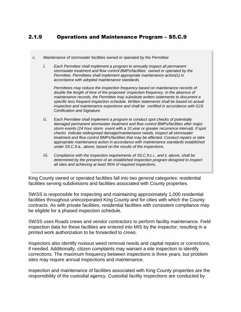
2.1.9 Operations and Maintenance Program – S5.C.9
King County owned or operated facilities fall into two general categories: residential facilities serving subdivisions and facilities associated with County properties. SWSS is responsible for inspecting and maintaining approximately 1,000 residential facilities throughout unincorporated King County and for cities with which the County contracts. As with private facilities, residential facilities with consistent compliance may be eligible for a phased inspection schedule. SWSS uses Roads crews and vendor contractors to perform facility maintenance. Field inspection data for these facilities are entered into MIS by the inspector, resulting in a printed work authorization to be forwarded to crews. Inspectors also identify noxious weed removal needs and capital repairs or corrections, if needed. Additionally, citizen complaints may warrant a site inspection to identify corrections. The maximum frequency between inspections is three years, but problem sites may require annual inspections and maintenance. Inspection and maintenance of facilities associated with King County properties are the responsibility of the custodial agency. Custodial facility inspections are conducted by
c. Maintenance of stormwater facilities owned or operated by the Permittee
i. Each Permittee shall implement a program to annually inspect all permanent stormwater treatment and flow control BMPs/facilities owned or operated by the Permittee. Permittees shall implement appropriate maintenance action(s) in accordance with adopted maintenance standards.
Permittees may reduce the inspection frequency based on maintenance records of double the length of time of the proposed inspection frequency. In the absence of maintenance records, the Permittee may substitute written statements to document a specific less frequent inspection schedule. Written statements shall be based on actual inspection and maintenance experience and shall be certified in accordance with G19 Certification and Signature.
ii. Each Permittee shall implement a program to conduct spot checks of potentially damaged permanent stormwater treatment and flow control BMPs/facilities after major storm events (24 hour storm event with a 10 year or greater recurrence interval). If spot checks indicate widespread damage/maintenance needs, inspect all stormwater treatment and flow control BMPs/facilities that may be affected. Conduct repairs or take appropriate maintenance action in accordance with maintenance standards established under S5.C.9.a., above, based on the results of the inspections.
iii. Compliance with the inspection requirements of S5.C.9.c.i., and ii. above, shall be determined by the presence of an established inspection program designed to inspect all sites and achieving at least 95% of required inspections.

SWSS or the custodial agency and range in frequency from several times per year to once annually. Spot inspections conducted after large rain events focus on the areas of greatest intensity based on rain gage data. Inspection programs are designed to inspect 100 percent of the facilities owned or operated by King County and at least 95 percent of required inspections are completed annually.

Attachment 2015 Annual Report Question #55:
If using a reduced inspection frequency on stormwater treatment and flow
control BMPs/facilities regulated by the Permittee for the first time during this
permit cycle, attach documentation per S5.C.9.b.ii.
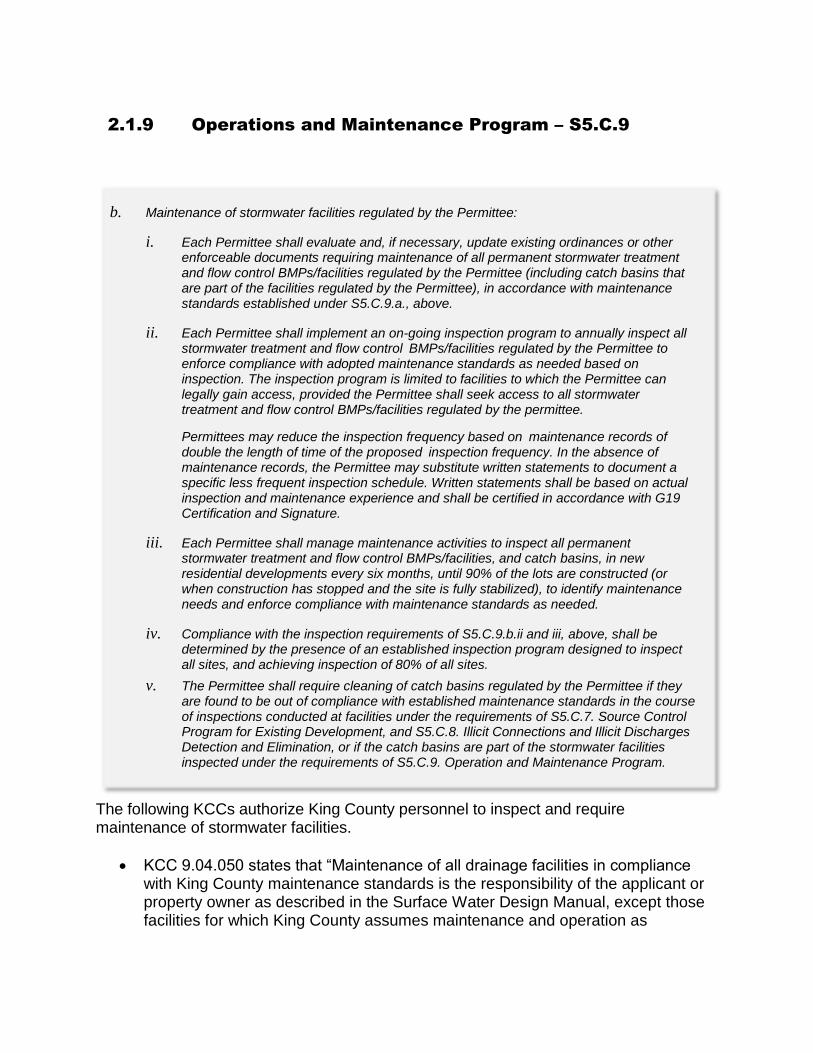
2.1.9 Operations and Maintenance Program – S5.C.9
The following KCCs authorize King County personnel to inspect and require maintenance of stormwater facilities.
KCC 9.04.050 states that “Maintenance of all drainage facilities in compliance with King County maintenance standards is the responsibility of the applicant or property owner as described in the Surface Water Design Manual, except those facilities for which King County assumes maintenance and operation as
b. Maintenance of stormwater facilities regulated by the Permittee:
i. Each Permittee shall evaluate and, if necessary, update existing ordinances or other enforceable documents requiring maintenance of all permanent stormwater treatment and flow control BMPs/facilities regulated by the Permittee (including catch basins that are part of the facilities regulated by the Permittee), in accordance with maintenance standards established under S5.C.9.a., above.
ii. Each Permittee shall implement an on-going inspection program to annually inspect all stormwater treatment and flow control BMPs/facilities regulated by the Permittee to enforce compliance with adopted maintenance standards as needed based on inspection. The inspection program is limited to facilities to which the Permittee can legally gain access, provided the Permittee shall seek access to all stormwater treatment and flow control BMPs/facilities regulated by the permittee.
Permittees may reduce the inspection frequency based on maintenance records of double the length of time of the proposed inspection frequency. In the absence of maintenance records, the Permittee may substitute written statements to document a specific less frequent inspection schedule. Written statements shall be based on actual inspection and maintenance experience and shall be certified in accordance with G19 Certification and Signature.
iii. Each Permittee shall manage maintenance activities to inspect all permanent stormwater treatment and flow control BMPs/facilities, and catch basins, in new residential developments every six months, until 90% of the lots are constructed (or when construction has stopped and the site is fully stabilized), to identify maintenance needs and enforce compliance with maintenance standards as needed.
iv. Compliance with the inspection requirements of S5.C.9.b.ii and iii, above, shall be determined by the presence of an established inspection program designed to inspect all sites, and achieving inspection of 80% of all sites.
v. The Permittee shall require cleaning of catch basins regulated by the Permittee if they are found to be out of compliance with established maintenance standards in the course of inspections conducted at facilities under the requirements of S5.C.7. Source Control Program for Existing Development, and S5.C.8. Illicit Connections and Illicit Discharges Detection and Elimination, or if the catch basins are part of the stormwater facilities inspected under the requirements of S5.C.9. Operation and Maintenance Program.

described in K.C.C 9.04.115 and 9.04.120 and the Surface Water Design Manual”.
KCC 9.12.050 gives designated employees authorization to “make such inspections and take such actions as may be required to enforce the provisions” of KCC 9.12.
Additionally, developers are required to record easements and covenants providing the County with right-of-entry and inspection of private drainage and stormwater control systems. Private facilities regulated by King County are inspected per Permit requirements. Inspections are generally conducted between July and October. In any given year, half of the private commercial facility inventory is visited by an inspector to confirm full compliance based on the maintenance standards in the SWDM. If any deficiencies are discovered, a Maintenance Correction Letter is sent, giving the property owner sufficient time to correct the problem before the end of the year. The property owner notifies SWSS when the work has been completed. Extensions may be granted if circumstances warrant and permit timelines can accommodate the extension. Progressive enforcement may be used when maintenance is not completed within the timelines specified by the County. The other half of the private commercial facilities regulated by King County complete a self-certified inspection in which they confirm full functionality of all facilities on their property. For those properties with a history of consistent compliance, the inspection frequency may be reduced contingent upon maintenance records. All compliance activities are tracked using a proprietary Maintenance Information System (MIS). At the end of the year, SWSS provides a SWM Fee discount report to the WLRD SWM Fee billing supervisor who then gives the report to the King County Department of Assessments. Property owners in compliance receive a SWM fee discount.
Attachment 2015 Annual Report Question #48:
Attach a summary of actions taken to characterize, trace and eliminate each illicit
discharge found by or reported to the permittee. For each illicit discharge, include
a description of actions according to required timelines per S5.C.8.d.iv.
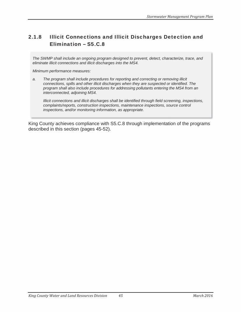
Stormwater Management Program Plan
2.1.8 Illicit Connections and Illicit Discharges Detection and Elimination – S5.C.8
King County achieves compliance with S5.C.8 through implementation of the programs described in this section (pages 45-52).
The SWMP shall include an ongoing program designed to prevent, detect, characterize, trace, andeliminate illicit connections and illicit discharges into the MS4.
Minimum performance measures:
a. The program shall include procedures for reporting and correcting or removing illicitconnections, spills and other illicit discharges when they are suspected or identified. Theprogram shall also include procedures for addressing pollutants entering the MS4 from aninterconnected, adjoining MS4.
Illicit connections and illicit discharges shall be identified through field screening, inspections,complaints/reports, construction inspections, maintenance inspections, source controlinspections, and/or monitoring information, as appropriate.
King County Water and Land Resources Division 45 March 2016

Stormwater Management Program Plan
b. No later than February 2, 2018, each Permittee shall evaluate and, if necessary, updateexisting ordinances or other regulatory mechanisms to effectively prohibit non-stormwater,illicit discharges, including spills, into the Permittee’s MS4.
i. Allowable Discharges: The ordinance or other regulatory mechanism does not need to prohibit the following categories of non-stormwater discharges:
(1) Diverted stream flows
(2) Rising ground waters
(3) Uncontaminated ground water infiltration (as defined at 40 CFR 35.2005(b)(20))
(4) Uncontaminated pumped ground water
(5) Foundation drains
(6) Air conditioning condensation
(7) Irrigation water from agricultural sources that is commingled with urban stormwater
(8) Springs
(9) Uncontaminated water from crawl space pumps
(10) Footing drains
(11) Flows from riparian habitats and wetlands
(12) Non-stormwater discharges authorized by another NPDES or State WasteDischarge permit
(13) Discharges from emergency firefighting activities in accordance withS2 Authorized Discharges
ii. Conditionally Allowable Discharges: The ordinance or other regulatory mechanism,may allow the following categories of non-stormwater discharges only if the statedconditions are met:
(1) Discharges from potable water sources including, but not limited to, water line flushing, hyperchlorinated water line flushing, fire hydrant system flushing, andpipeline hydrostatic test water. Planned discharges shall be dechlorinated to atotal residual chlorine concentration of 0.1 ppm or less, pH-adjusted if necessary,and volumetrically and velocity controlled to prevent resuspension of sediments inthe MS4.
(2) Discharges from lawn watering and other irrigation runoff. These dischargesshall be minimized through, at a minimum, public education activities (see S5.C.10.) and water conservation efforts.
King County Water and Land Resources Division 46 March 2016
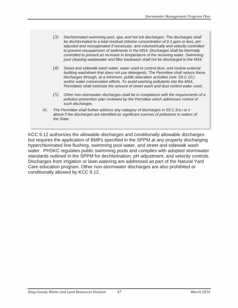
Stormwater Management Program Plan
KCC 9.12 authorizes the allowable discharges and conditionally allowable discharges but requires the application of BMPs specified in the SPPM at any property discharging hyperchlorinated line flushing, swimming pool water, and street and sidewalk wash water. PHSKC regulates public swimming pools and complies with adopted stormwater standards outlined in the SPPM for dechlorination, pH adjustment, and velocity controls.Discharges from irrigation or lawn watering are addressed as part of the Natural Yard Care education program. Other non-stormwater discharges are also prohibited or conditionally allowed by KCC 9.12.
(3) Dechlorinated swimming pool, spa, and hot tub discharges. The discharges shallbe dechlorinated to a total residual chlorine concentration of 0.1 ppm or less, pH-adjusted and reoxygenated if necessary, and volumetrically and velocity controlledto prevent resuspension of sediments in the MS4. Discharges shall be thermallycontrolled to prevent an increase in temperature of the receiving water. Swimmingpool cleaning wastewater and filter backwash shall not be discharged to the MS4.
(4) Street and sidewalk wash water, water used to control dust, and routine externalbuilding washdown that does not use detergents. The Permittee shall reduce thesedischarges through, at a minimum, public education activities (see S5.C.10.)and/or water conservation efforts. To avoid washing pollutants into the MS4,Permittees shall minimize the amount of street wash and dust control water used.
(5) Other non-stormwater discharges shall be in compliance with the requirements of apollution prevention plan reviewed by the Permittee which addresses control ofsuch discharges.
iii. The Permittee shall further address any category of discharges in S5.C.8.b.i or ii above if the discharges are identified as significant sources of pollutants to waters ofthe State.
King County Water and Land Resources Division 47 March 2016

Stormwater Management Program Plan
King County addresses this MS4 field screening requirement through the implementation of two departmental programs. These programs are:
SWSS CSP:SWSS will conduct a Conveyance Screening Program (CSP) in 2016 to check known stormwater outfalls and other system connections for dry weather flowand other evidence, using these as indicators of possible illicit discharge. At least12 percent of known, mapped locations where stormwater leaves the County’s MS4 will be inspected for evidence of illicit connections/illicit discharges (IC/ID) under the CSP program. MS4 locations identified for further investigation will trigger follow-up in situ field screening to further assess the likelihood of IC/ID. If warranted, laboratory analytical samples will be collected; sampling and analysis depends on both the follow-up screening results and on nearby observed land uses (e.g., potential pollution sources, including failing septic systems, illicit sewer connections, commercial/industrial sites or other possible pollutant sources).In 2016, the CSP will focus on urban and higher density areas throughout King County. It will also focus throughout the Bear/Evans Creek and Issaquah Creek drainage basins, including urban, higher density rural and rural areas.
Roads CBIMP:
c. Each Permittee shall implement an ongoing program designed to detect and identify non-stormwater discharges and illicit connections into the Permittee’s MS4. The program shall include the following components:
i. Procedures for conducting investigations of the Permittees MS4, including fieldscreening and methods for identifying potential sources. These procedures mayalso include source control inspections.
The permittee shall implement a field screening methodology appropriate to the characteristics of the MS4 and water quality concerns. Screening for illicit connectionsmay be conducted using the Illicit Discharge Detection and Elimination: A GuidanceManual for Program Development and Technical Assessments, Center for WatershedProtection, October 2004; or another method of comparable or improved effectiveness.The Permittee shall document the field screening methodology in the relevant Annual Report.
(1) Each Permittee shall implement an ongoing field screening program of, on average, 12% of the Permittee’s known conveyance systems each calendaryear.
(2) Each City shall field screen all the conveyance systems within the Permittee’sincorporated area at least once between February 2007 and July 31, 2018.
(3) Each County shall field screen all the conveyance systems within the Permittee’surban/higher density rural sub-basins at least once between February 2007 andJuly 31, 2018.
King County Water and Land Resources Division 48 March 2016
Stormwater Management Program Plan
Roads will conduct its annual Catch Basin Inspection and Maintenance Program (CBIMP). Roads plans to inspect 100 percent of known, mapped catch basin circuits on an annual basis, including inspecting a minimum of 25 percent of the catch basins within each circuit. It is anticipated that a minimum of 30 percent of known, mapped, Roads-owned catch basins County-wide will be inspected annually during CBIMP tasks. While implementing CBIMP, Roads staff will actively look for evidence of IC/ID and will record whether or not such evidence is observed. Catch basins identified for further investigation will trigger follow-up in situ field screening to further assess the likelihood of IC/ID.
County personnel involved in the SWSS CSP and Roads’ CBIMP have received and, as needed, will continue to receive comparable training to ensure consistency across the program elements.
Citizen reports are received by the County in a number of ways.
Roads 24-hour hotline (206-296-8100 or 800-KCROADS)SWSS Water Quality hotline (206-477-4811)Illegal Dumping Hotline (206-296-SITE or 866-431-7483)DPER inspector contact information posted on signage at each development/redevelopment project site in unincorporated King County that is permitted by DPERIllegal Dumping web form (http://your.kingcounty.gov/solidwaste/cleanup/report-dumping.asp)Online report form for drainage and water quality problems (http://www.kingcounty.gov/environment/waterandland/stormwater/problem-investigation-line/report-form.aspx)
ii. A publicly-listed and publicized hotline or other telephone number for public reportingof spills and other illicit discharges.
iii. An ongoing training program for all municipal field staff, who, as part of their normal job responsibilities might come into contact with or otherwise observe an illicitdischarge or illicit connection to the MS4, on the identification of an illicit discharge and/or connection, and on the proper procedures for reporting and responding to the illicit discharge and/or connection. Follow-up training shall be provided as needed to address changes in procedures, techniques, requirements, or staffing. Permittees shall document and maintain records of the training provided and staff trained.
d. Each Permittee shall implement an ongoing program designed to address illicit discharges,including spills and illicit connections, into the Permittee’s MS4. The program shall include:
King County Water and Land Resources Division 49 March 2016
Stormwater Management Program Plan
Each King County agency with field personnel subject to this requirement is responsible for training those employees to identify an illicit discharge or connection and to properly report and respond. The County continues to review its programs and identify additional personnel that need this training. The County also continues to assess the need for follow-up training as regulations, procedures, or personnel change.
Training records are currently managed by each agency. However, an effort is underway to explore options for standardizing and/or centralizing tracking of permit-related training.
The County implements a number of programs to address illicit connections and illicitdischarges. These programs were created to address issues that occur on King County properties and throughout the ROW in unincorporated King County.
i. Procedures for characterizing the nature of, and potential public or environmental threatposed by, any illicit discharges found by or reported to the Permittee. Procedures shalladdress the evaluation of whether the discharge must be immediately contained andsteps to be taken for containment of the discharge.
ii. Procedures for tracing the source of an illicit discharge; including visual inspections,and when necessary, opening manholes, using mobile cameras, collecting andanalyzing water samples, and/or other detailed inspection procedures.
iii. Procedures for eliminating the discharge; including notification of appropriate authorities; notification of the property owner; technical assistance; follow-upinspections; and escalating enforcement and legal actions if the discharge is noteliminated.
iv. Compliance with the provisions in S5.C.8.d.i, ii, and iii, above, shall be achieved bymeeting the following timelines:
(1) Immediately respond to all illicit discharges, including spills, which are determinedto constitute a threat to human health, welfare, or the environment consistent withGeneral Condition G3.
(2) Investigate (or refer to the appropriate agency with authority to act) within 7 days, on average, any complaints, reports or monitoring information that indicates apotential illicit discharge.
(3) Initiate an investigation within 21 days of any report or discovery of a suspectedillicit connection to determine the source of the connection, the nature andvolume of discharge through the connection, and the party responsible for the connection.
(4) Upon confirmation of an illicit connection, use enforcement authority in adocumented effort to eliminate the illicit connection within 6 months. All knownillicit connections to the MS4 shall be eliminated.
e. Permittees shall train staff who are responsible for identification, investigation, termination,cleanup, and reporting of illicit discharges, including spills and illicit connections, to conduct
King County Water and Land Resources Division 50 March 2016
Stormwater Management Program Plan
Generally, illicit connections are handled through SWSS, whereas, dumped waste and spilled materials are managed through the County agency responsible for the property upon which the incident occurred.
Any illicit connection identified by a County employee or through an external party (for example, citizen complaint) is reported to SWSS and an investigation is initiated. A Water Quality Engineer traces the source to identify the responsible party and uses progressive enforcement to achieve the elimination of the illicit connection. Records related to the investigation are managed in the SWSS Complaint Tracker database.
When the County receives a report of an illicit discharge, including spilled or dumped materials, outside of its jurisdiction, the appropriate municipality is notified of the situation.
Reports of illicit discharges within King County’s jurisdiction are routed to the appropriate agency for response. Some agencies, such as Roads and Transit, have in-house capacity and training to conduct spill response activities for most commonly-occurring spills (for example, vehicular fluids or paint). Other agencies, such as FMD, donot possess in-house spill response capacity and rely on spill response contractors or request support from other County agencies. The County maintains multiple on-call spill response contracts to facilitate timely responses. The County has also built a collaborative working relationship with Ecology’s Northwest Regional Office Spills Program and the County occasionally calls upon this group for spill response assistance.
For protection of human health, property and the environment, spill incidents exceeding the County’s capacity for in-house response are always referred to a spill response contractor.
King County trains field personnel on the identification, investigation, termination, cleanup and reporting of illicit discharges and illicit connections, as appropriate for their job duties. As the agencies most likely to have their personnel involved in spill response, Roads and Transit have developed customized hazardous waste and spill response training for personnel responding to illegally dumped or spilled materials. This training has been adapted for use by other County agencies and other local jurisdictions. The training also includes guidelines for when an outside spill response contractor should be called in.
Additionally, tenants and operators at the King County International Airport (KCIA) receive annual spill response training, including procedures for notification, response
these activities. Follow-up training shall be provided as needed to address changes in procedures, techniques, requirements, or staff. Permittees shall document and maintain records of the training provided and the staff trained.
f. Each Permittee shall either participate in a regional emergency response program, or develop
King County Water and Land Resources Division 51 March 2016
Stormwater Management Program Plan
and reporting, as well as preventative measures.
The County continues to review its programs and identify additional personnel that need this training. It also continues to assess the need for follow-up training as regulations, procedures, or personnel change. Training records are currently managed by each agency. However, an effort is underway to explore options for standardizing and/or centralizing tracking of permit-related training.
The County maintains several spill response programs, as described above, under S5.C.8.d. King County has six programs that track and maintain records of the IDDE program,including documentation of inspections, complaint/spill response, and other enforcement records. These programs are outlined below:
1) SWSS maintains tracking programs, including a complaint tracker and water quality compliance tracker which track response, findings, and enforcement actions.
2) Roads tracks and maintains electronic and paper copies of IDDE records through Roads’ Service Request system in Cityworks and various internal tracking forms maintained by the Emergency Response Unit. These include forms and records specific to the spill response program, catch basin inspection records, and drainage evaluation records.
3) The Illegal Dumping Hotline’s application operated by SWD records and tracks reported citizen complaints.
4) Transit’s Environmental Compliance Office maintains electronic spreadsheets detailing fleet-related spills, conveyance system IDDE inspections, and employee training.
5) PHSKC maintains a proprietary database designed for public health agencies that maintains records of inspections, complaints, responses and enforcement actions.
6) Airport tracks and maintains spill and IC/ID records for incidents occurring at the KCIA.
Staff time and resources spent implementing these programs are tracked electronicallythrough the County’s Oracle Finance System.
As appropriate, spills and other select incidents are reported to Ecology’s Environmental Report Tracking System database.
and implement procedures to investigate and respond to spills and improper disposal into theMS4 owned or operated by the Permittee.
g. Recordkeeping: Each Permittee shall track and maintain records of the activities conducted tomeet the requirements of this section.
King County Water and Land Resources Division 52 March 2016

Attachment 2015 Annual Report Question #40b:
Cite field methodology used in the Comments field.
2.1.8 Illicit Connections and Illicit Discharges Detection and
Elimination – S5.C.8
King County addresses this MS4 field screening requirement through the implementation of two departmental programs. These programs are: SWSS CSP:
SWSS will conduct a Conveyance Screening Program (CSP) in 2016 to check known stormwater outfalls and other system connections for dry weather flow and other evidence, using these as indicators of possible illicit discharge. At least 12 percent of known, mapped locations where stormwater leaves the County’s MS4 will be inspected for evidence of illicit connections/illicit discharges (IC/ID) under the CSP program. MS4 locations identified for further investigation will trigger follow-up in situ field screening to further assess the likelihood of IC/ID. If warranted, laboratory analytical samples will be collected; sampling and analysis depends on both the follow-up screening results and on nearby observed land uses (e.g., potential pollution sources, including failing septic systems, illicit sewer connections, commercial/industrial sites or other possible pollutant sources).
c. Each Permittee shall implement an ongoing program designed to detect and identify non-stormwater discharges and illicit connections into the Permittee’s MS4. The program shall include the following components:
i. Procedures for conducting investigations of the Permittees MS4, including field screening and methods for identifying potential sources. These procedures may also include source control inspections.
The permittee shall implement a field screening methodology appropriate to the characteristics of the MS4 and water quality concerns. Screening for illicit connections may be conducted using the Illicit Discharge Detection and Elimination: A Guidance Manual for Program Development and Technical Assessments, Center for Watershed Protection, October 2004; or another method of comparable or improved effectiveness. The Permittee shall document the field screening methodology in the relevant Annual Report.
(1) Each Permittee shall implement an ongoing field screening program of, on average, 12% of the Permittee’s known conveyance systems each calendar year.
(2) Each City shall field screen all the conveyance systems within the Permittee’s incorporated area at least once between February 2007 and July 31, 2018.
(3) Each County shall field screen all the conveyance systems within the Permittee’s urban/higher density rural sub-basins at least once between February 2007 and July 31, 2018.

In 2016, the CSP will focus on urban and higher density areas throughout King County. It will also focus throughout the Bear/Evans Creek and Issaquah Creek drainage basins, including urban, higher density rural and rural areas.
Roads CBIMP:
Roads will conduct its annual Catch Basin Inspection and Maintenance Program (CBIMP). Roads plans to inspect 100 percent of known, mapped catch basin circuits on an annual basis, including inspecting a minimum of 25 percent of the catch basins within each circuit. It is anticipated that a minimum of 30 percent of known, mapped, Roads-owned catch basins County-wide will be inspected annually during CBIMP tasks. While implementing CBIMP, Roads staff will actively look for evidence of IC/ID and will record whether or not such evidence is observed. Catch basins identified for further investigation will trigger follow-up in situ field screening to further assess the likelihood of IC/ID. County personnel involved in the SWSS CSP and Roads’ CBIMP have received and, as needed, will continue to receive comparable training to ensure consistency across the program elements.
Citizen reports are received by the County in a number of ways.
Roads 24-hour hotline (206-296-8100 or 800-KCROADS)
SWSS Water Quality hotline (206-477-4811)
Illegal Dumping Hotline (206-296-SITE or 866-431-7483)
DPER inspector contact information posted on signage at each development/redevelopment project site in unincorporated King County that is permitted by DPER
Illegal Dumping web form (http://your.kingcounty.gov/solidwaste/cleanup/report-dumping.asp)
Online report form for drainage and water quality problems (http://www.kingcounty.gov/environment/waterandland/stormwater/problem-investigation-line/report-form.aspx)
ii. A publicly-listed and publicized hotline or other telephone number for public reporting of spills and other illicit discharges.

Attachment 2015 Annual Report Question #36:
Attach a summary of actions taken to implement the source control program per
S5.C.7.b.iii and S5.C.7.b.iv.
2.1.7 Source Control Program for Existing Development – S5.C.7
Direct mailing and telephoning is not an effective means of communication because there are no County records that identify the operator of a given site, their contact information, or the type of business occupying the site. Instead, information about activities that may generate pollutants and the source control requirements applicable to those activities is provided in person during a site inspection, or if no one is present, by mail. This provides the benefit of customizing the information provided to the needs of each particular site. This information is also available on King County’s website (http://www.kingcounty.gov/environment/waterandland/stormwater/documents/pollution-prevention-manual.aspx).
Approximately 400 stormwater pollution prevention inspections are planned for 2016, roughly 20 percent of our estimated inventory.
Annexations may occur within King County over the next few years. Combined with the addition of new businesses and the closing of other businesses, there is some uncertainty about the number of businesses in unincorporated King County from year to year. The number of sites under this program will be in constant flux, requiring annual analysis to determine the 20 percent inspection goal.
SWSS investigates all water quality complaints from citizens and County agencies as
iii. Permittees shall implement an inspection program for sites identified pursuant to
S5.C.7.b.ii above.
(1) All identified sites with a business address shall be provided, by mail, telephone, electronic communications, or in person, information about activities that may generate pollutants and the source control requirements applicable to those activities. This information may be provided all at one time or spread out over the permit term to allow for some tailoring and distribution of the information during site inspections.
(2) The Permittee shall annually complete the number of inspections equal to 20% of the businesses and/or properties listed in their source control inventory to assure BMP effectiveness and compliance with source control requirements. The Permittee may count follow up compliance inspections at the same site toward the 20% inspection rate. The Permittee may select which sites to inspect each year and is not required to inspect 100% of sites over a 5-year period. Sites may be prioritized for inspection based on their land use category, potential for pollution generation, proximity to receiving waters, or to address an identified pollution problem within a specific geographic area or sub-basin.
(3) The Permittee shall annually complete the number of inspections equal to 20% of the businesses and/or properties listed in their source control inventory to assure BMP effectiveness and compliance with source control requirements. The Permittee may count follow up compliance inspections at the same site toward the 20% inspection rate. The Permittee may select which sites to inspect each year and is not required to inspect 100% of sites over a 5-year period. Sites may be prioritized for inspection based on their land use category, potential for pollution generation, proximity to receiving waters, or to address an identified pollution problem within a specific geographic area or sub-basin.
well as those referred to SWSS by outside agencies. Complaints can be made through online submissions (http://www.kingcounty.gov/environment/waterandland/stormwater/problem-investigation-line.aspx) or by calling the published complaint line (206-477-4811). Calls are first screened to determine if the problem is within unincorporated King County and stormwater quality-related (if not, the complainant is given the appropriate contact, whenever possible) and then assigned to an investigator for immediate follow-up. As part of the complaint resolution, technical assistance is provided on any required source control BMPs and a follow up letter and information is sent, if necessary. Additional inspections or enforcement may follow. Depending on the nature of the problem, additional agencies may be brought in to assist in achieving compliance. All legitimate (relevant) complaints are inspected.
SWSS has had an enforcement program in place since 1995. The procedures for progressive enforcement include issuing a detailed Corrective Action Letter that specifies exactly what needs to be done in order to come into compliance and sets a deadline. King County personnel work with property owners, tenants, and business operators to assist them achieve compliance. Their assistance may include additional site visits, bringing in outside resources such as vouchers for hazardous waste disposal and storage, facilitating conversations between property owners and tenants, providing written materials, posting BMP signs, or phone calls and emails. When compliance is achieved, a Compliance Letter is sent.
King County makes every effort to bring facilities into compliance using site audits and technical assistance but in the very rare instance where compliance is not achieved, notices of violation are issued and additional enforcement action taken. Additionally, commercial sites are denied a discount on their SWM fee if source control BMPs are not implemented and if the onsite stormwater system is not properly maintained.
Records of inspection results, site photos, correspondence, etc., are all kept in paper and electronic formats. There are activity logs for each site, which document inspections dates, contacts, illicit connections, referrals to other agencies, etc.
i.v. Each Permittee shall implement a progressive enforcement policy to require sites to come into compliance with stormwater requirements within a reasonable time period as specified below:
(1) If the Permittee determines, through inspections or otherwise, that a site has failed to adequately implement required BMPs, the Permittee shall take appropriate follow-up action(s) which may include: phone calls, reminder letters or follow-up inspections.
(2) When a Permittee determines that a facility has failed to adequately implement BMPs after a follow-up inspection, the Permittee shall take enforcement action as established through authority in its municipal code and ordinances, or through the judicial system.
(3) Each Permittee shall maintain records, including documentation of each site visit, inspection reports, warning letters, notices of violations, and other enforcement records, demonstrating an effort to bring facilities into compliance. Each Permittee shall also maintain records of sites that are not inspected because the property owner denies entry.
(4) A Permittee may refer non-emergency violations of local ordinances to Ecology, provided, the Permittee also makes a documented effort of progressive enforcement. At a minimum, a Permittee’s enforcement effort shall include documentation of inspections and warning letters or notices of violation.

King County has an ongoing training program for employees conducting source control work.
SWSS, the primary agency implementing the source control program, trains staff and updates
staff training, as needed. King County continues to update its list of staff requiring training under
this section and addresses their training as they are identified whether current employees or
new hires.
iv. Permittees shall train staff who are responsible for implementing the source control program to conduct these activities. The ongoing training program shall cover the legal authority for source control, source control BMPs and their proper application, inspection protocols, lessons learned, typical cases, and enforcement procedures. Follow-up training shall be provided as needed to address changes in procedures, techniques, requirements, or staff. Permittees shall document and maintain records of the training provided and the staff trained.

Attachment 2015 Annual Report Question #34b:
Attach an updated list of planned, individual projects schedules for
implementation during this permit term with the information and formatting
specified in Appendix 11 (S5.C.6.c).

Department of Natural Resources and Parks
Water and Land Resources Division Stormwater Services Section
Created: March 2014, Updated: February 2016
STRUCTURAL STORMWATER CONTROL PROGRAM
Projects planned and implemented as part of King County’s Structural Stormwater Control
Program seek to reduce stormwater quantity and quality impacts to waters of the state caused by
existing developed land, and to prevent such impacts anticipated to be caused by future land
development that are not adequately addressed through regulations or other required
programmatic actions of the County's Stormwater Management Program (SWMP). Such impacts
include, but are not limited to: increased runoff peaks, durations, and volumes; loss of
groundwater recharge; increased pollutants in discharges; increased erosion and sedimentation;
physical, chemical, and biological damage to aquatic habitat and biota; increased flooding and
property damage; and, increased risks to human health and safety. The overall goal is intended to
be achieved incrementally over time through implementation of the program's capital projects
each year.
The planning process used to develop the Structural Stormwater Control Program, including:
The geographic scale of the planning process.
Issues and regulations addressed.
Steps in the planning process.
Types of characterization information considered.
Amount budgeted for implementation.
The public involvement process.
A description of the prioritization process, procedures and criteria used to select the
Structural Stormwater Control projects.
King County's planning process for its Structural Stormwater Controls Program is described
below for the five types of projects that must be considered as part of the Structural Stormwater
Controls Program per Permit Condition S.5.C.6.a.i.(1) through (5).
Stormwater Retrofit Projects
For stormwater retrofit projects (project types (1), (2), and (3) specified in Permit condition
S.5.C.6.a.i), the planning process is currently in a state of flux as the County tries different
planning approaches to identify, assess, and prioritize such projects for future funding. The
stormwater retrofit projects considered include new flow control facilities/BMPs, new treatment
facilities/BMPs, and retrofit of existing treatment and/or flow control facilities. The three
approaches currently underway include the following:
STRUCTURAL STORMWATER CONTROL PROGRAM
Page 2 of 5
Small Stream Basin Retrofit Planning Program
One of King County's approaches to stormwater retrofit planning is to focus on small,
substantially developed stream basins. In such basins, the harmful effects of stormwater
runoff from developed land are more pronounced and directly measureable due to less
dilution by water from other sources (i.e., runoff from undeveloped land or groundwater
inflow). In addition, full basin retrofitting will take less time and expense, so the
expected benefits of retrofitting can be achieved and measured sooner in order to inform
future retrofitting in larger basins. Another aspect of this approach is to focus on basins
wherein degradation of stream health and water quality has been measured by monitoring
data. This provides baseline data for assessing the effectiveness of retrofit actions.
In 2012, the County completed a high level capital needs assessment of 64 small stream
basins scattered across unincorporated King County that have documented degradation of
stream health and water quality based on two sets of available monitoring data. One was
benthic index of biologic integrity (BIBI) data available at
http://www.pugetsoundstreambenthos.org/ and the other was water quality assessment
data available at http://apps.ecy.wa.gov/wqawa2008/viewer.htm. The 64-basin
assessment (updated in 2013 to 67 basins) is a compilation of key information for each
basin (e.g., basin size, land covers, soil types, BIBI scores, impaired water body listings,
etc.) which is used to prioritize the basins for stormwater retrofitting efforts. Included in
the prioritization information is Ecology's integrity score, which comes from Ecology's
Stormwater Target Watersheds map provided in their 2013 Solicitation for Proposals to
Conduct Stormwater Retrofit Planning and Pre-design. The 67 basins are currently
prioritized to favor the following:
Relatively small basin size with a significant amount of developed land
Presence of BIBI monitoring stations with baseline data from which to measure
retrofit effectiveness
Baseline BIBI data in the fair or worse range for the basin
Developed vs. predeveloped runoff peaks indicating a likely unstable or scoured
stream channel
Location within an Ecology stormwater target watershed with a high integrity
score
The funding for this program was established for the first time in 2013/14 and has been
used to leverage grant funding for two small basins so far: Evans Creek Tributary 108;
and, May Creek Tributary 291A. A third basin, Monticello Creek, will also receive
funding from this program for the County's share of the match required for an Ecology
retrofit planning grant just applied for by the City of Redmond. Program funding and
grant funding add up to about $300,000 for each of these basins. This cost includes basin
characterization, runoff modeling, and design of a basin-wide system of conceptual
retrofits that work together to meet a regulatory performance standard at the mouth of the
basin (e.g., one or more of Ecology's regulatory performance standards for LID, flow
control, and treatment). The cost also includes public outreach on the planning effort and

STRUCTURAL STORMWATER CONTROL PROGRAM
Page 3 of 5
several pre-designs of retrofit projects selected from the basin-wide system of conceptual
retrofits based on cost vs. benefit. The pre-designs will be used to compete for
construction grant funding expected to be offered by Ecology later this year.
Additional funding appropriation for this program will be requested in the 2017/18
biennium budget request. This funding will be used to (1) do conceptual retrofit planning
in two new high priority small stream basins, (2) do additional pre-designs for the small
stream basins where conceptual planning has already been done, and (3) leverage grant
funding for construction of retrofit projects.
A variation of this planning approach will be explored wherein opportunity sites are
identified within a basin for retrofit projects that can be designed to meet a regulatory
performance standard for the developed area draining to the site. Such an approach can
potentially generate pre-designs more quickly because the step of basin-wide systematic
design is skipped.
Larger Basin Plans
The County has and will continue to participate in larger basin planning efforts to identify
stormwater control projects and other actions to mitigate the stormwater impacts of past,
present, and future development. During this permit term, the County is leading three
multi-jurisdictional planning efforts that have or will identify stormwater retrofit
needs. These include the WRIA 9 Stormwater Retrofit Plan, the Miller/Walker Creeks
Stormwater Retrofit Plan, and the Bear Creek Stormwater Basin Plan. Public outreach
was or will be a component of all these planning efforts.
The WRIA 9 stormwater retrofit planning effort, now nearing completion, is an EPA-
grant-funded effort with an estimated cost of $1.3 million. It has identified unit retrofit
needs (i.e., number of rain gardens, number of rain barrels, and number of detention
facilities) across the developed landscape that would collectively achieve flow regime
restoration goals in the many streams that are tributary to the Green/Duwamish
River. Although the effort did not identify, site, or pre-design specific retrofit projects, it
did estimate the overall cost of stormwater flow control retrofitting in each of the stream
basins that comprise the study area and suggested that a large share of the retrofitting
could be achieved through regulatory redevelopment requirements as each basin slowly
redevelops over the next 30 to 100 years. Such information will be useful in prioritizing
and structuring future, more detailed retrofit planning efforts in the watershed.
The Miller/Walker Creeks stormwater retrofit planning effort is funded through an
Ecology/National Estuary Program grant. The estimated project cost is approximately
$250,000. It will identify, assess, and prioritize 80 sites across the basin for stormwater
retrofit projects. The criteria for prioritization are currently being developed by the
multi-jurisdictional project management team. The planning effort will select at least
three sites and develop pre-designs for retrofit projects at those sites. The pre-designs

STRUCTURAL STORMWATER CONTROL PROGRAM
Page 4 of 5
will be used to compete for construction grant funding expected to be offered by Ecology
later this year and in coming years.
The Bear Creek stormwater basin planning effort is estimated to cost over $2 million and
is a multi-jurisdictional effort being performed by King County to comply with the
Permit's watershed-scale stormwater planning requirement. Because the Bear Creek
basin is largely developed, a major focus of the effort will be to identify a conceptual list
of retrofit projects for future implementation. Further planning will be needed after the
basin plan to develop pre-designs for these projects to seek local funding and state/federal
grant funding for implementation. The order of project implementation will be likely be
prioritized based on cost vs. benefit.
Property Acquisition Projects for Flow Control/Water Quality Benefits
King County prioritizes acquisitions based on a variety of information, including but not limited
to salmon recovery plans, the Flood Hazard Management Plan, basin plans, habitat studies,
recreation plans, stormwater management plans, and staff expertise.
Generally, lands identified for acquisition have conservation value in one or more of the
following categories: agricultural production, forestry, ecological protection and restoration,
flood risk reduction, passive recreation, strategic growth management community separators, and
stormwater benefits (both by preserving naturally high functioning sites and by acquiring sites
for facilities). It is often the case that a single property will meet more than one conservation
objective. For example, a forested property in the headwaters of a rural stream system may have
fish and wildlife benefits, forest health benefits, and stormwater benefits related to preserving
water quality and retaining surface water.
Increasingly, staff who plan acquisition strategies are examining the landscape for acquisitions
that would achieve multiple benefits. In many cases such planning efforts are informed by
sophisticated modeling efforts, including the Department of Ecology’s Watershed
Characterization model. The Watershed Characterization model is particularly useful in
stormwater acquisition planning for its ability to identify basins across the landscape where
additional protection and restoration actions would have the greatest impact on improving water
quality and water flow functions.
King County has also developed a process to address Type 2 drainage problems in the Structural
Stormwater Control program. King County’s Stormwater Services Section is made aware of
Type 2 drainage problems either through drainage complaints or while conducting outfall
reconnaissance surveys. If a Type 2 drainage problem is found, each problem is to be evaluated
through a feasibility study to prioritize the problem and identify potential solutions. Upon
completion of the feasibility study, a plan is enacted to address and correct the problem area.
Maintenance Projects with Capital Construction Cost ≥ $25,000

STRUCTURAL STORMWATER CONTROL PROGRAM
Page 5 of 5
The planning process for these types of projects includes the following steps:
1) A problem is identified during regular inspection of a stormwater control facility/best
management practice (BMP) that appears to require capital construction to fix.
2) An engineering review is performed to confirm the problem and a rough estimated cost to fix.
3) The problem is referred to the stormwater capital program where more detailed assessment
and costing is done to create a capital project.
4) The problem is prioritized with other stormwater capital projects for funding.
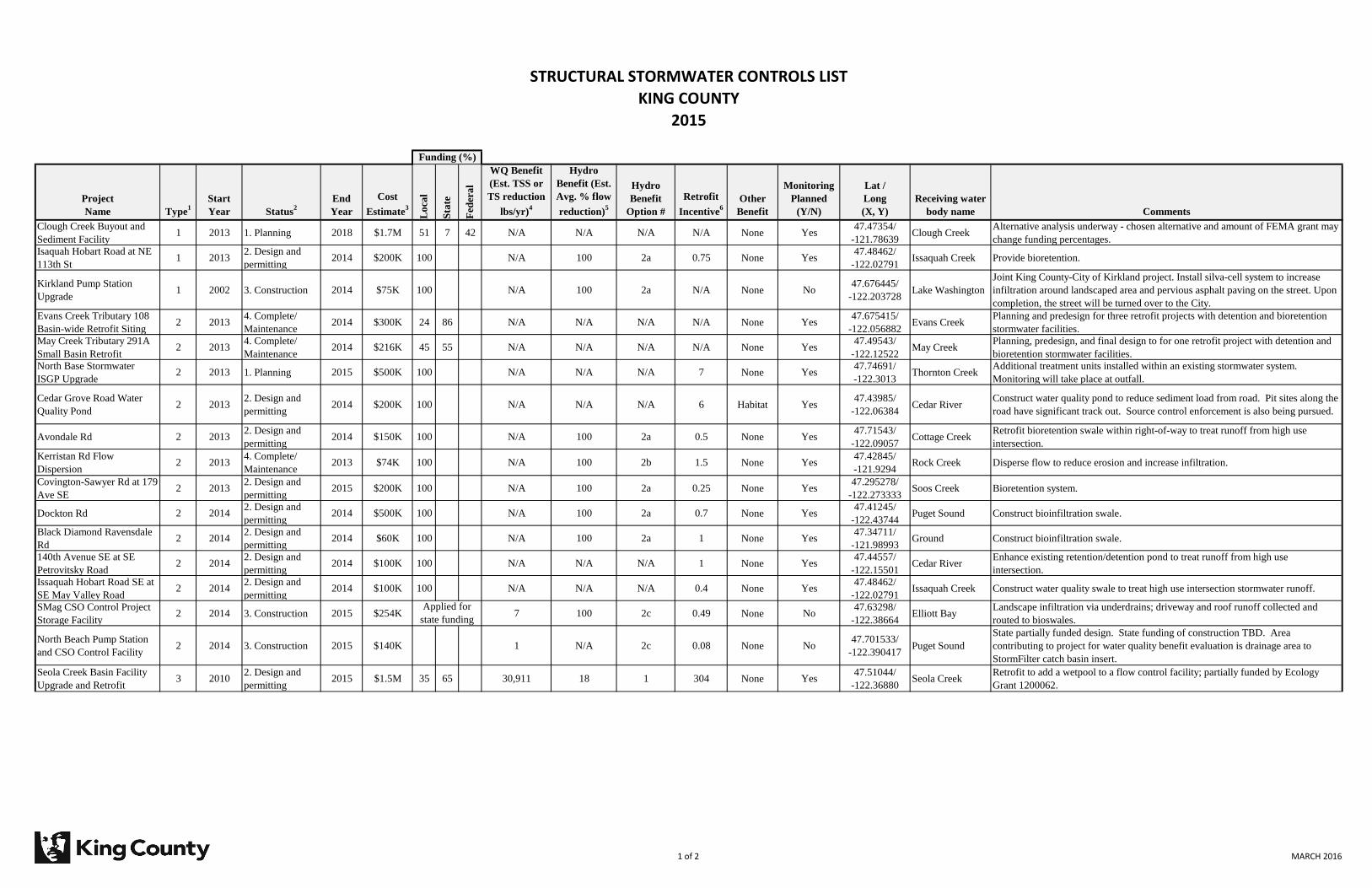
STRUCTURAL STORMWATER CONTROLS LIST
KING COUNTY
2015
Project
Name Type1
Start
Year Status2
End
Year
Cost
Estimate3
Lo
cal
Sta
te
Fed
era
l
WQ Benefit
(Est. TSS or
TS reduction
lbs/yr)4
Hydro
Benefit (Est.
Avg. % flow
reduction)5
Hydro
Benefit
Option #
Retrofit
Incentive6
Other
Benefit
Monitoring
Planned
(Y/N)
Lat /
Long
(X, Y)
Receiving water
body name Comments
Clough Creek Buyout and
Sediment Facility1 2013 1. Planning 2018 $1.7M 51 7 42 N/A N/A N/A N/A None Yes
47.47354/
-121.78639Clough Creek
Alternative analysis underway - chosen alternative and amount of FEMA grant may
change funding percentages.
Isaquah Hobart Road at NE
113th St1 2013
2. Design and
permitting2014 $200K 100 N/A 100 2a 0.75 None Yes
47.48462/
-122.02791Issaquah Creek Provide bioretention.
Kirkland Pump Station
Upgrade1 2002 3. Construction 2014 $75K 100 N/A 100 2a N/A None No
47.676445/
-122.203728Lake Washington
Joint King County-City of Kirkland project. Install silva-cell system to increase
infiltration around landscaped area and pervious asphalt paving on the street. Upon
completion, the street will be turned over to the City.
Evans Creek Tributary 108
Basin-wide Retrofit Siting2 2013
4. Complete/
Maintenance2014 $300K 24 86 N/A N/A N/A N/A None Yes
47.675415/
-122.056882Evans Creek
Planning and predesign for three retrofit projects with detention and bioretention
stormwater facilities.
May Creek Tributary 291A
Small Basin Retrofit2 2013
4. Complete/
Maintenance2014 $216K 45 55 N/A N/A N/A N/A None Yes
47.49543/
-122.12522May Creek
Planning, predesign, and final design to for one retrofit project with detention and
bioretention stormwater facilities.
North Base Stormwater
ISGP Upgrade2 2013 1. Planning 2015 $500K 100 N/A N/A N/A 7 None Yes
47.74691/
-122.3013Thornton Creek
Additional treatment units installed within an existing stormwater system.
Monitoring will take place at outfall.
Cedar Grove Road Water
Quality Pond2 2013
2. Design and
permitting2014 $200K 100 N/A N/A N/A 6 Habitat Yes
47.43985/
-122.06384Cedar River
Construct water quality pond to reduce sediment load from road. Pit sites along the
road have significant track out. Source control enforcement is also being pursued.
Avondale Rd 2 20132. Design and
permitting2014 $150K 100 N/A 100 2a 0.5 None Yes
47.71543/
-122.09057Cottage Creek
Retrofit bioretention swale within right-of-way to treat runoff from high use
intersection.
Kerristan Rd Flow
Dispersion2 2013
4. Complete/
Maintenance2013 $74K 100 N/A 100 2b 1.5 None Yes
47.42845/
-121.9294Rock Creek Disperse flow to reduce erosion and increase infiltration.
Covington-Sawyer Rd at 179
Ave SE 2 2013
2. Design and
permitting2015 $200K 100 N/A 100 2a 0.25 None Yes
47.295278/
-122.273333Soos Creek Bioretention system.
Dockton Rd 2 20142. Design and
permitting2014 $500K 100 N/A 100 2a 0.7 None Yes
47.41245/
-122.43744Puget Sound Construct bioinfiltration swale.
Black Diamond Ravensdale
Rd2 2014
2. Design and
permitting2014 $60K 100 N/A 100 2a 1 None Yes
47.34711/
-121.98993Ground Construct bioinfiltration swale.
140th Avenue SE at SE
Petrovitsky Road 2 2014
2. Design and
permitting2014 $100K 100 N/A N/A N/A 1 None Yes
47.44557/
-122.15501Cedar River
Enhance existing retention/detention pond to treat runoff from high use
intersection.
Issaquah Hobart Road SE at
SE May Valley Road2 2014
2. Design and
permitting2014 $100K 100 N/A N/A N/A 0.4 None Yes
47.48462/
-122.02791Issaquah Creek Construct water quality swale to treat high use intersection stormwater runoff.
SMag CSO Control Project
Storage Facility2 2014 3. Construction 2015 $254K 7 100 2c 0.49 None No
47.63298/
-122.38664Elliott Bay
Landscape infiltration via underdrains; driveway and roof runoff collected and
routed to bioswales.
North Beach Pump Station
and CSO Control Facility2 2014 3. Construction 2015 $140K 1 N/A 2c 0.08 None No
47.701533/
-122.390417Puget Sound
State partially funded design. State funding of construction TBD. Area
contributing to project for water quality benefit evaluation is drainage area to
StormFilter catch basin insert.
Seola Creek Basin Facility
Upgrade and Retrofit3 2010
2. Design and
permitting2015 $1.5M 35 65 30,911 18 1 304 None Yes
47.51044/
-122.36880Seola Creek
Retrofit to add a wetpool to a flow control facility; partially funded by Ecology
Grant 1200062.
Funding (%)
Applied for
state funding
1 of 2 MARCH 2016
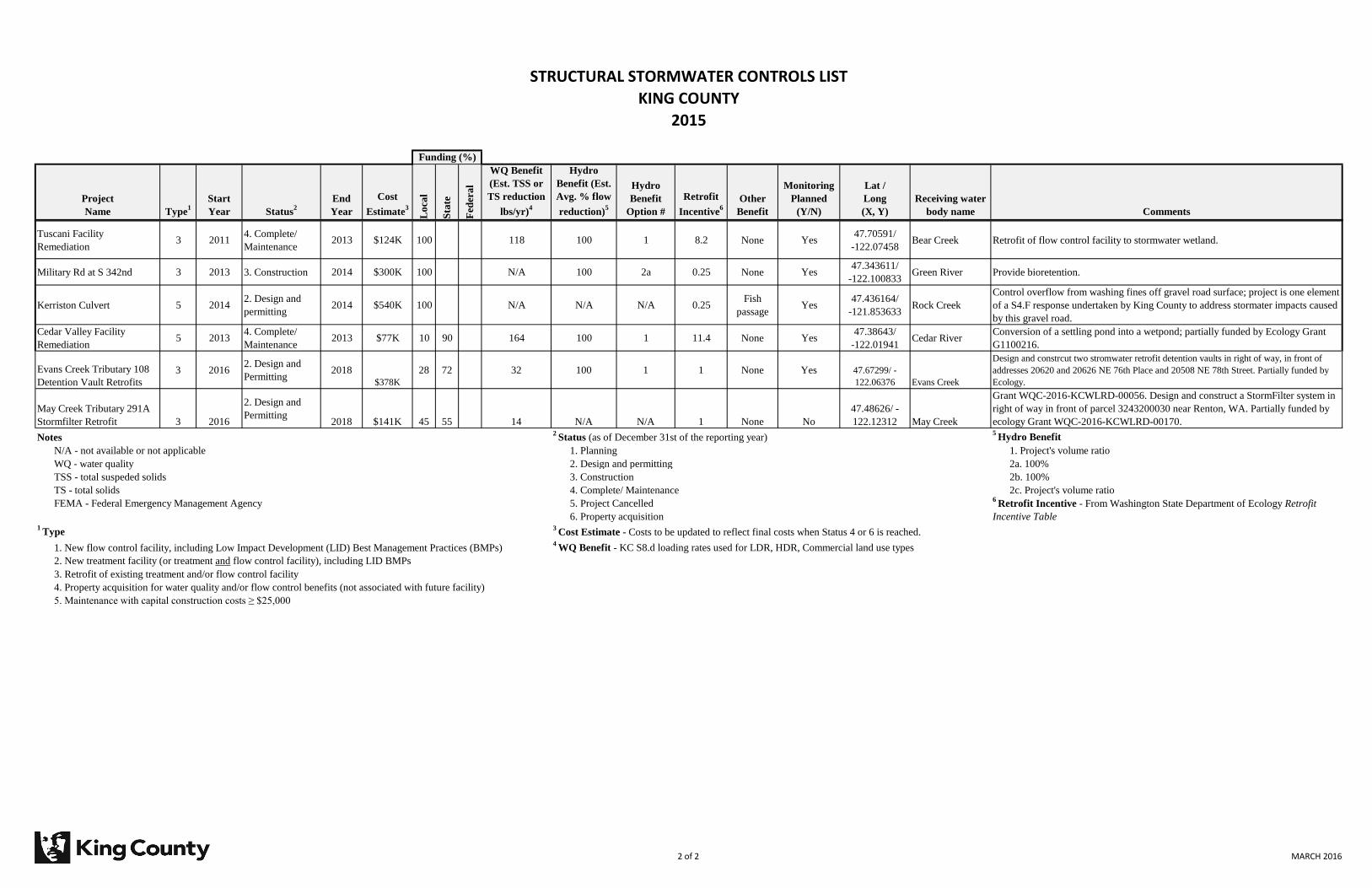
STRUCTURAL STORMWATER CONTROLS LIST
KING COUNTY
2015
Project
Name Type1
Start
Year Status2
End
Year
Cost
Estimate3
Lo
cal
Sta
te
Fed
era
l
WQ Benefit
(Est. TSS or
TS reduction
lbs/yr)4
Hydro
Benefit (Est.
Avg. % flow
reduction)5
Hydro
Benefit
Option #
Retrofit
Incentive6
Other
Benefit
Monitoring
Planned
(Y/N)
Lat /
Long
(X, Y)
Receiving water
body name Comments
Funding (%)
Tuscani Facility
Remediation3 2011
4. Complete/
Maintenance2013 $124K 100 118 100 1 8.2 None Yes
47.70591/
-122.07458Bear Creek Retrofit of flow control facility to stormwater wetland.
Military Rd at S 342nd 3 2013 3. Construction 2014 $300K 100 N/A 100 2a 0.25 None Yes47.343611/
-122.100833Green River Provide bioretention.
Kerriston Culvert 5 20142. Design and
permitting2014 $540K 100 N/A N/A N/A 0.25
Fish
passageYes
47.436164/
-121.853633Rock Creek
Control overflow from washing fines off gravel road surface; project is one element
of a S4.F response undertaken by King County to address stormater impacts caused
by this gravel road.
Cedar Valley Facility
Remediation5 2013
4. Complete/
Maintenance2013 $77K 10 90 164 100 1 11.4 None Yes
47.38643/
-122.01941Cedar River
Conversion of a settling pond into a wetpond; partially funded by Ecology Grant
G1100216.
Evans Creek Tributary 108
Detention Vault Retrofits
3 20162. Design and
Permitting2018
$378K
28 72 32 100 1 1 None Yes 47.67299/ -
122.06376 Evans Creek
Design and constrcut two stromwater retrofit detention vaults in right of way, in front of
addresses 20620 and 20626 NE 76th Place and 20508 NE 78th Street. Partially funded by
Ecology.
May Creek Tributary 291A
Stormfilter Retrofit 3 2016
2. Design and
Permitting2018 $141K 45 55 14 N/A N/A 1 None No
47.48626/ -
122.12312 May Creek
Grant WQC-2016-KCWLRD-00056. Design and construct a StormFilter system in
right of way in front of parcel 3243200030 near Renton, WA. Partially funded by
ecology Grant WQC-2016-KCWLRD-00170.
Notes2
Status (as of December 31st of the reporting year)5
Hydro Benefit
N/A - not available or not applicable 1. Planning 1. Project's volume ratio
WQ - water quality 2. Design and permitting 2a. 100%
TSS - total suspeded solids 3. Construction 2b. 100%
TS - total solids 4. Complete/ Maintenance 2c. Project's volume ratio
FEMA - Federal Emergency Management Agency 5. Project Cancelled
6. Property acquisition1
Type3
Cost Estimate - Costs to be updated to reflect final costs when Status 4 or 6 is reached.
1. New flow control facility, including Low Impact Development (LID) Best Management Practices (BMPs)4
WQ Benefit - KC S8.d loading rates used for LDR, HDR, Commercial land use types
2. New treatment facility (or treatment and flow control facility), including LID BMPs
3. Retrofit of existing treatment and/or flow control facility
4. Property acquisition for water quality and/or flow control benefits (not associated with future facility)
5. Maintenance with capital construction costs ≥ $25,000
6 Retrofit Incentive - From Washington State Department of Ecology Retrofit
Incentive Table
2 of 2 MARCH 2016

Attachment 2015 Annual Report Question #30:
Attach a summary of the LID review and revision process that includes the
requirements listed in S5.C.5.b.ii.

Document Name:Code chapter,
rules, standards, and other
enforceable documents
Section reference, date last
updated, page number, etcName of Reviewer(s)
Action taken to meet
Permit requirements
Describe/Note How Revision(s) made to meet permit requirements OR if No revision(s) was made to this
document, explain why.im
pervio
us su
rfaces
loss o
f native
vegetation
storm
water ru
no
ff
LID Code-related requirements - Reporting Template for King CountyMeasures to minimize:
KCC Title 9--Surface Water
Management
KCC 9.04--Surface Water Runoff
Policy--updates before council
Curt Crawford, Mark
Wilgus, David Batts, Jeff
Pray, Molly Johnson,
Lydia Reynolds
Amend existing code Title 9.04 is being updated to be consistent w/changes proposed within the revised KC Surface Water Design
manual. A new Core Requirement 9 addressing LID/FCBMPs requirements has been added to provide emphasis
and clarity in the code and SWDM. The current SWDM (2009) implemented by this code requires broad
application of FCBMPs. The proposed edits to the 2009 KCSWDM required for equivalency to ECY’s SMMWW
require LID/FCBMPs to be applied potentially more broadly by evaluating implemenatation using a max feasible
approach. KC’s proposal includes the maximum feasibility approach and also a minimum floor level application
regardless of feasilbity facilitated by including BMPs not subject to soil type related feasilbity criteria such as
native vegetation preservation and reduced impervious footprint BMPs as options to achieve these minimum
levels. Preferred BMP of full dispersion must be first evaluated and this requires native vegetation preservation.
Target surfaces requiring LID implementation now include roadways consistent w/Ecology requirements. KC
requirements will also include requiring LID BMPs for existing impervious surfaces added after Jan 2001 that are
not already mitigated-this goes further than Ecology re: BMP/LID application.
King County Surface Water Design
Manual (SWDM)
KCSWDM--adopted as a public
rule that will be signed once
council acts on the ordinance
above
Curt Crawford, Mark
Wilgus, David Batts, Jeff
Pray, Molly Johnson,
Lydia Reynolds
Amend existing code The KC SWDM was updated to achieve equivalency w/Ecology’s SMMWW. See above.
KCC 9.08--Surface Water
Management Program
KCC 9.08.070--Rate structure--
last update in 2010
Mark Wilgus No changes/ action taken This portion of the code already provides rate structure that ties rates to amount of increased surface and
stormwater.
KCC 9.08--Surface Water
Management Program
KCC 9.08.080--Rate adjustments
and appeals--last update in 2012
Mark Wilgus No changes/ action taken By providing a discount on the rate of stormwater fees for maintaining 65% forest and no more than 20%
impervious dispersed through retained forest, this section of the code already incentivizes minimizing
impervious surfaces, preservation of native vegetation, and the use of dispersion techniques.
KCC 14.42--King County Road
Standards
KCC 14.42.030--Applicability of
Road Standards--awaiting council
action on update
Lydia Reynolds, Mark
Wilgus
Amend existing code The revised SWDM, which controls all development in unincorporated King County as well as King County
projects outside the unincorporated area, REQUIRES the use of LID in road projects to the maximum extent
feasible. Standard details and specifications for the use of LID for roads will be incorporated into the KC Road
Design and Construction Standards at its next update. In the interim, the KC Road Engineer will provide to the
KC Dept. of Permitting requirements and standards for LID used on road projects. Projects proposing LID on
road projects that vary from the standards and requirements will require specific review and approval by the KC
Road Engineer or designee. A new section is being added to KCC 14.42.030 clarifying that LID must be used on
road projects consistent with the requirements of the revised SWDM.
1
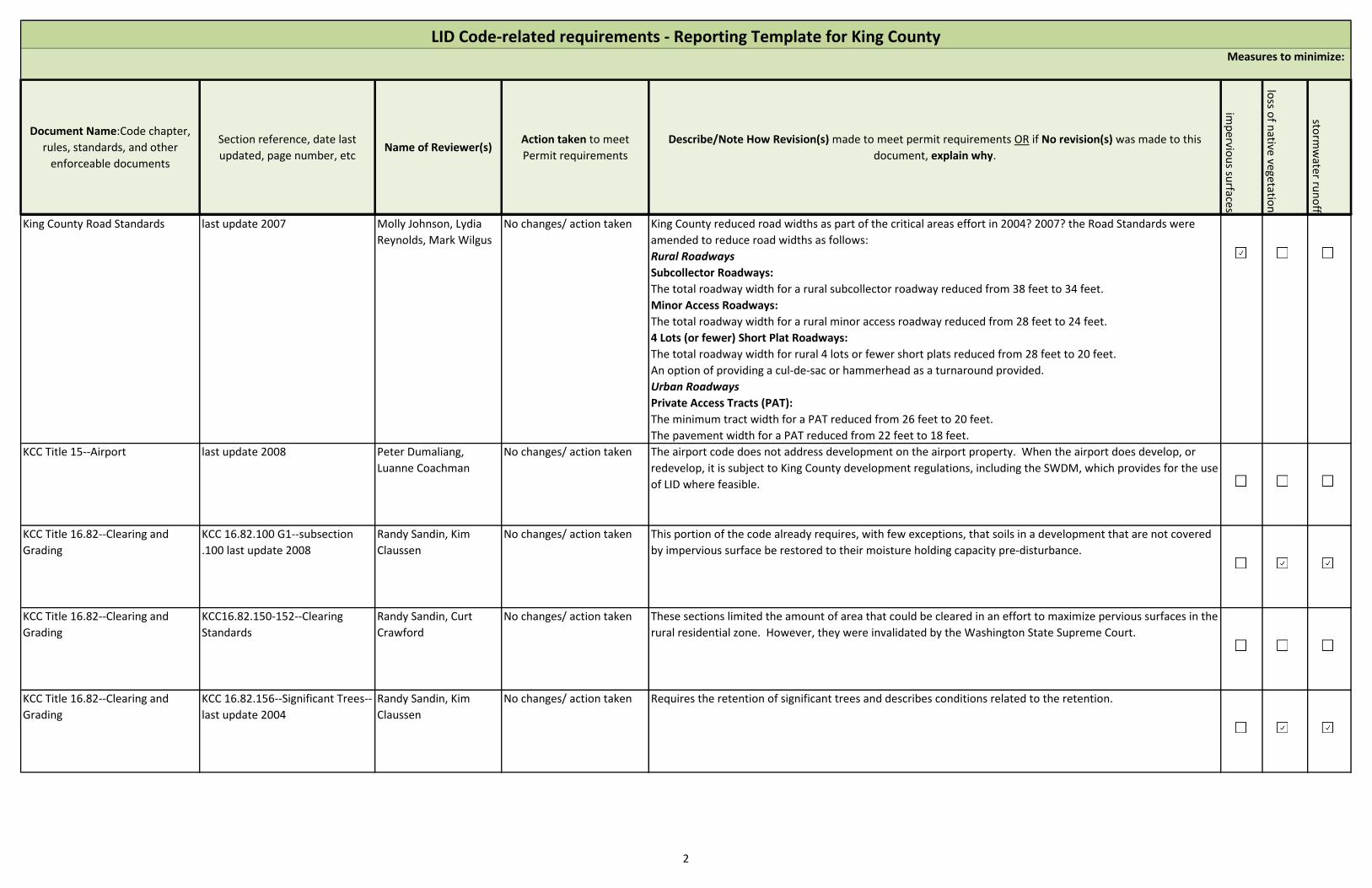
Document Name:Code chapter,
rules, standards, and other
enforceable documents
Section reference, date last
updated, page number, etcName of Reviewer(s)
Action taken to meet
Permit requirements
Describe/Note How Revision(s) made to meet permit requirements OR if No revision(s) was made to this
document, explain why.im
pervio
us su
rfaces
loss o
f native
vegetation
storm
water ru
no
ff
LID Code-related requirements - Reporting Template for King CountyMeasures to minimize:
King County Road Standards last update 2007 Molly Johnson, Lydia
Reynolds, Mark Wilgus
No changes/ action taken King County reduced road widths as part of the critical areas effort in 2004? 2007? the Road Standards were
amended to reduce road widths as follows:
Rural Roadways
Subcollector Roadways:
The total roadway width for a rural subcollector roadway reduced from 38 feet to 34 feet.
Minor Access Roadways:
The total roadway width for a rural minor access roadway reduced from 28 feet to 24 feet.
4 Lots (or fewer) Short Plat Roadways:
The total roadway width for rural 4 lots or fewer short plats reduced from 28 feet to 20 feet.
An option of providing a cul-de-sac or hammerhead as a turnaround provided.
Urban Roadways
Private Access Tracts (PAT):
The minimum tract width for a PAT reduced from 26 feet to 20 feet.
The pavement width for a PAT reduced from 22 feet to 18 feet.
KCC Title 15--Airport last update 2008 Peter Dumaliang,
Luanne Coachman
No changes/ action taken The airport code does not address development on the airport property. When the airport does develop, or
redevelop, it is subject to King County development regulations, including the SWDM, which provides for the use
of LID where feasible.
KCC Title 16.82--Clearing and
Grading
KCC 16.82.100 G1--subsection
.100 last update 2008
Randy Sandin, Kim
Claussen
No changes/ action taken This portion of the code already requires, with few exceptions, that soils in a development that are not covered
by impervious surface be restored to their moisture holding capacity pre-disturbance.
KCC Title 16.82--Clearing and
Grading
KCC16.82.150-152--Clearing
Standards
Randy Sandin, Curt
Crawford
No changes/ action taken These sections limited the amount of area that could be cleared in an effort to maximize pervious surfaces in the
rural residential zone. However, they were invalidated by the Washington State Supreme Court.
KCC Title 16.82--Clearing and
Grading
KCC 16.82.156--Significant Trees--
last update 2004
Randy Sandin, Kim
Claussen
No changes/ action taken Requires the retention of significant trees and describes conditions related to the retention.
2
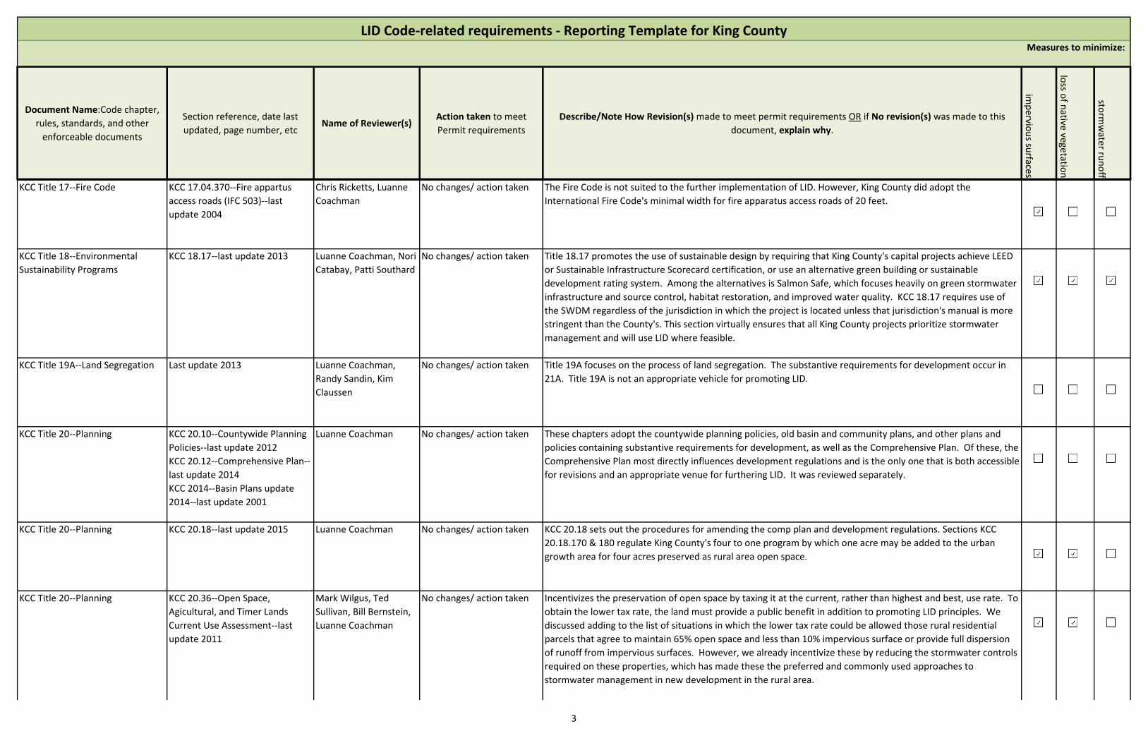
Document Name:Code chapter,
rules, standards, and other
enforceable documents
Section reference, date last
updated, page number, etcName of Reviewer(s)
Action taken to meet
Permit requirements
Describe/Note How Revision(s) made to meet permit requirements OR if No revision(s) was made to this
document, explain why.im
pervio
us su
rfaces
loss o
f native
vegetation
storm
water ru
no
ff
LID Code-related requirements - Reporting Template for King CountyMeasures to minimize:
KCC Title 17--Fire Code KCC 17.04.370--Fire appartus
access roads (IFC 503)--last
update 2004
Chris Ricketts, Luanne
Coachman
No changes/ action taken The Fire Code is not suited to the further implementation of LID. However, King County did adopt the
International Fire Code's minimal width for fire apparatus access roads of 20 feet.
KCC Title 18--Environmental
Sustainability Programs
KCC 18.17--last update 2013 Luanne Coachman, Nori
Catabay, Patti Southard
No changes/ action taken Title 18.17 promotes the use of sustainable design by requiring that King County's capital projects achieve LEED
or Sustainable Infrastructure Scorecard certification, or use an alternative green building or sustainable
development rating system. Among the alternatives is Salmon Safe, which focuses heavily on green stormwater
infrastructure and source control, habitat restoration, and improved water quality. KCC 18.17 requires use of
the SWDM regardless of the jurisdiction in which the project is located unless that jurisdiction's manual is more
stringent than the County's. This section virtually ensures that all King County projects prioritize stormwater
management and will use LID where feasible.
KCC Title 19A--Land Segregation Last update 2013 Luanne Coachman,
Randy Sandin, Kim
Claussen
No changes/ action taken Title 19A focuses on the process of land segregation. The substantive requirements for development occur in
21A. Title 19A is not an appropriate vehicle for promoting LID.
KCC Title 20--Planning KCC 20.10--Countywide Planning
Policies--last update 2012
KCC 20.12--Comprehensive Plan--
last update 2014
KCC 2014--Basin Plans update
2014--last update 2001
Luanne Coachman No changes/ action taken These chapters adopt the countywide planning policies, old basin and community plans, and other plans and
policies containing substantive requirements for development, as well as the Comprehensive Plan. Of these, the
Comprehensive Plan most directly influences development regulations and is the only one that is both accessible
for revisions and an appropriate venue for furthering LID. It was reviewed separately.
KCC Title 20--Planning KCC 20.18--last update 2015 Luanne Coachman No changes/ action taken KCC 20.18 sets out the procedures for amending the comp plan and development regulations. Sections KCC
20.18.170 & 180 regulate King County's four to one program by which one acre may be added to the urban
growth area for four acres preserved as rural area open space.
KCC Title 20--Planning KCC 20.36--Open Space,
Agicultural, and Timer Lands
Current Use Assessment--last
update 2011
Mark Wilgus, Ted
Sullivan, Bill Bernstein,
Luanne Coachman
No changes/ action taken Incentivizes the preservation of open space by taxing it at the current, rather than highest and best, use rate. To
obtain the lower tax rate, the land must provide a public benefit in addition to promoting LID principles. We
discussed adding to the list of situations in which the lower tax rate could be allowed those rural residential
parcels that agree to maintain 65% open space and less than 10% impervious surface or provide full dispersion
of runoff from impervious surfaces. However, we already incentivize these by reducing the stormwater controls
required on these properties, which has made these the preferred and commonly used approaches to
stormwater management in new development in the rural area.
3
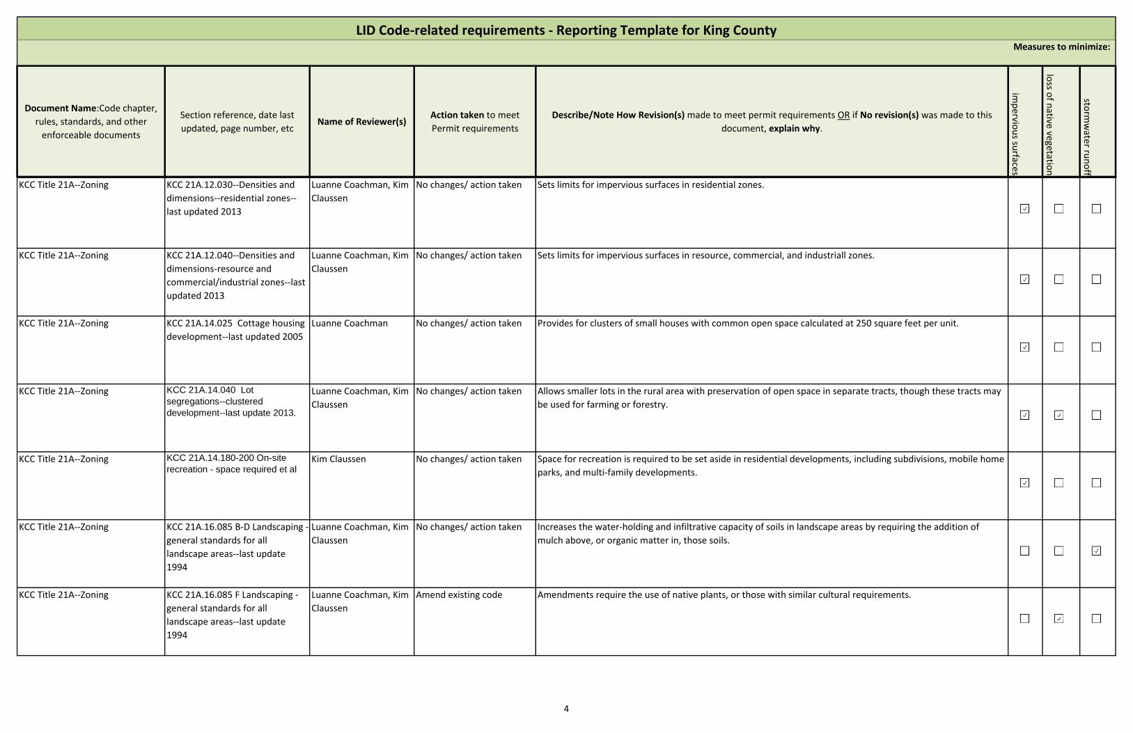
Document Name:Code chapter,
rules, standards, and other
enforceable documents
Section reference, date last
updated, page number, etcName of Reviewer(s)
Action taken to meet
Permit requirements
Describe/Note How Revision(s) made to meet permit requirements OR if No revision(s) was made to this
document, explain why.im
pervio
us su
rfaces
loss o
f native
vegetation
storm
water ru
no
ff
LID Code-related requirements - Reporting Template for King CountyMeasures to minimize:
KCC Title 21A--Zoning KCC 21A.12.030--Densities and
dimensions--residential zones--
last updated 2013
Luanne Coachman, Kim
Claussen
No changes/ action taken Sets limits for impervious surfaces in residential zones.
KCC Title 21A--Zoning KCC 21A.12.040--Densities and
dimensions-resource and
commercial/industrial zones--last
updated 2013
Luanne Coachman, Kim
Claussen
No changes/ action taken Sets limits for impervious surfaces in resource, commercial, and industriall zones.
KCC Title 21A--Zoning KCC 21A.14.025 Cottage housing
development--last updated 2005
Luanne Coachman No changes/ action taken Provides for clusters of small houses with common open space calculated at 250 square feet per unit.
KCC Title 21A--Zoning KCC 21A.14.040 Lot
segregations--clustered
development--last update 2013.
Luanne Coachman, Kim
Claussen
No changes/ action taken Allows smaller lots in the rural area with preservation of open space in separate tracts, though these tracts may
be used for farming or forestry.
KCC Title 21A--Zoning KCC 21A.14.180-200 On-site
recreation - space required et alKim Claussen No changes/ action taken Space for recreation is required to be set aside in residential developments, including subdivisions, mobile home
parks, and multi-family developments.
KCC Title 21A--Zoning KCC 21A.16.085 B-D Landscaping -
general standards for all
landscape areas--last update
1994
Luanne Coachman, Kim
Claussen
No changes/ action taken Increases the water-holding and infiltrative capacity of soils in landscape areas by requiring the addition of
mulch above, or organic matter in, those soils.
KCC Title 21A--Zoning KCC 21A.16.085 F Landscaping -
general standards for all
landscape areas--last update
1994
Luanne Coachman, Kim
Claussen
Amend existing code Amendments require the use of native plants, or those with similar cultural requirements.
4
Document Name:Code chapter,
rules, standards, and other
enforceable documents
Section reference, date last
updated, page number, etcName of Reviewer(s)
Action taken to meet
Permit requirements
Describe/Note How Revision(s) made to meet permit requirements OR if No revision(s) was made to this
document, explain why.im
pervio
us su
rfaces
loss o
f native
vegetation
storm
water ru
no
ff
LID Code-related requirements - Reporting Template for King CountyMeasures to minimize:
KCC Title 21A--Zoning KCC 21A.16.085 Landscaping -
general standards for all
landscape areas--last update
1994
Luanne Coachman Developed new code New subsection G authorizes the use of landscape areas for bioretention as long as they meet both the
bioretention requirements of the SWDM and the landscaping requirements of KCC 21A.16.
KCC Title 21A--Zoning KCC 21A.24 Critical Areas Randy Sandin, Luanne
Coachman
No changes/ action taken Requires critical area buffers, that are retained as open space, and also the preservation of critical areas
KCC Title 21A--Zoning KCC 21A.24.020 Applicability--last
updated 2004
Randy Sandin No changes/ action taken With few, exceptions, any alteration to an aquatic area, wetland, steep slope, landslide hazard area, or their
respective buffer requires a permit. Even projects that are below the threshold for stormwater review are
required to implement erosion and sediment control best management practices. This exceeds the minimum
standards established by Ecology.
KCC Title 21A--Zoning KCC 21A.24.045 Allowed
Alterations--last updated
Randy Sandin No changes/ action taken This section identifies what types of alterations are allowed within selected critical areas and conditions under
which they are allowed. If an alteration is not included on the table, it may still be allowed as an exception. All
alterations, whether allowed outright or as an exception are required to meet the development standards
applicable to that critical area, INCLUDING, impact avoidance and mitigation.
KCC Title 21A--Zoning KCC 21A.24.045 D.19 Allowed
Alterations--last updated 2013
Randy Sandin No changes/ action taken This provision was added in 2013 and was intended to encourage landowners to enhance critical areas under
certain circumstances. With noxious weed removal, we do not require permits provided they are using methods
such as mowing or hand held or light equipment that does not disturb the duff layer and they replant with
native vegetation.
KCC Title 21A--Zoning KCC 21A.24.045 D.23 Allowed
Alterations
Randy Sandin No changes/ action taken Similar to D.19, requirements to use hand tools for vegetation management and BMPs to encourage native
vegetation reduce soil compaction and support the proliferation of native plants.
KCC Title 21A--Zoning KCC 21A.24.051 Agricultural
Activities Development Standards-
-last updated 2013
Randy Sandin No changes/ action taken The allowance for alteration to certain critical areas for ongoing agricultural maintenance activities and for
expansion of agricultural operations require preparation of a farm management plan. This provision of code
provides for regulatory flexibility through adoption of best management practices to preserve soil health,
minimize water quality impacts from farm operations, etc.
5
Document Name:Code chapter,
rules, standards, and other
enforceable documents
Section reference, date last
updated, page number, etcName of Reviewer(s)
Action taken to meet
Permit requirements
Describe/Note How Revision(s) made to meet permit requirements OR if No revision(s) was made to this
document, explain why.im
pervio
us su
rfaces
loss o
f native
vegetation
storm
water ru
no
ff
LID Code-related requirements - Reporting Template for King CountyMeasures to minimize:
KCC Title 21A--Zoning KCC 21A.24.051 D.2 Agricultural
Activities Development Standards
Randy Sandin No changes/ action taken Encourages LID principles, especially retention of native vegetation.
KCC Title 21A--Zoning KCC 21A.24.051 D.3 Agricultural
Activities Development Standards
Randy Sandin No changes/ action taken Encourages LID principles, especially implementation of water quality BMPs.
KCC Title 21A--Zoning KCC 21A.24.051 E Agricultural
Activities Development Standards
Randy Sandin No changes/ action taken Encourages LID principles, especially retention of native vegetation.
KCC Title 21A--Zoning KCC 21A.24.055 Rural
Stewardship Plans--last updated
2012
Randy Sandin No changes/ action taken This provision allows for regulatory flexibility through committing to a stewardship program that focuses on
preserving or enhancing native vegetation, minimize3 impacts to high quality wetlands and aquatic areas,
preserving or enhancing natural hydrologic conditions, etc.
KCC Title 21A--Zoning KCC 21A.24.055 E. 3 & 4; F.2 & 3
Rural Stewardship Plans--last
update 2013
Randy Sandin No changes/ action taken Encourages LID principles, especially retention of native vegetation.
KCC Title 21A--Zoning KCC 21A.24.125--Avoiding
Impacts to Critical Areas--last
update 2004
Randy Sandin No changes/ action taken This encourages LID principles, at least within critical areas by requiring avoidance, minimization and mitigation.
KCC Title 21A--Zoning KCC 21A.24.180 C & D--last
update 2013
Randy Sandin No changes/ action taken These sections were added in 2013 and are intended to encourage the LID principle of preserving, maintaining
and enhancing native vegetation.
6
Document Name:Code chapter,
rules, standards, and other
enforceable documents
Section reference, date last
updated, page number, etcName of Reviewer(s)
Action taken to meet
Permit requirements
Describe/Note How Revision(s) made to meet permit requirements OR if No revision(s) was made to this
document, explain why.im
pervio
us su
rfaces
loss o
f native
vegetation
storm
water ru
no
ff
LID Code-related requirements - Reporting Template for King CountyMeasures to minimize:
KCC Title 21A--Zoning KCC 21A.24.185 Vegetation
Management Plans--last update
2013
Randy Sandin No changes/ action taken These sections were added in 2013 and are intended to encourage the LID principle of preserving, maintaining
and enhancing native vegetation.
KCC Title 21A--Zoning KCC 21A.24.310 C Steep Slope
Hazard Areas--last update 2004
Randy Sandin No changes/ action taken Requires retention of vegetation.
KCC Title 21A--Zoning KCC 21A.24.325 A.3.b Wetlands-
buffers--last update 2010
Luanne Coachman No changes/ action taken The list of "Measures to minimize impacts" includes LID BMPs for changes in water regime and planting native
plants for degraded buffer conditions.
KCC Title 21A--Zoning KCC 21A.24.335 A Wetlands-
development standards and
alterations--last update 2008
Luanne Coachman No changes/ action taken Requires the use of native plants in wetlands and wetland buffers.
KCC Title 21A--Zoning KCC21A.24.365 C & E Aquatic
Areas-development standards
and alterations--last update 2008
Luanne Coachman No changes/ action taken Requires maintenance of moisture-holding capacity of the topsoil layer and either the preservation of the duff
layer, or the use of it elsewher on the site.
KCC Title 21A--Zoning KCC 21A.24.388 E Wildlife Habitat
Conservation Areas and Wildlife
Networks--last update 2004
Randy Sandin, Luanne
Coachman
No changes/ action taken Promotes the maintenance of natural soil conditions and reestablishing or enhancing native vegetation.
KCC Title 21A--Zoning KCC 21A.25--Shorelines Randy Sandin No changes/ action taken Contains areas of overlap with KCC 21A.24. Where there is a conflict between the two, the one most protective
of the environment applies.
7
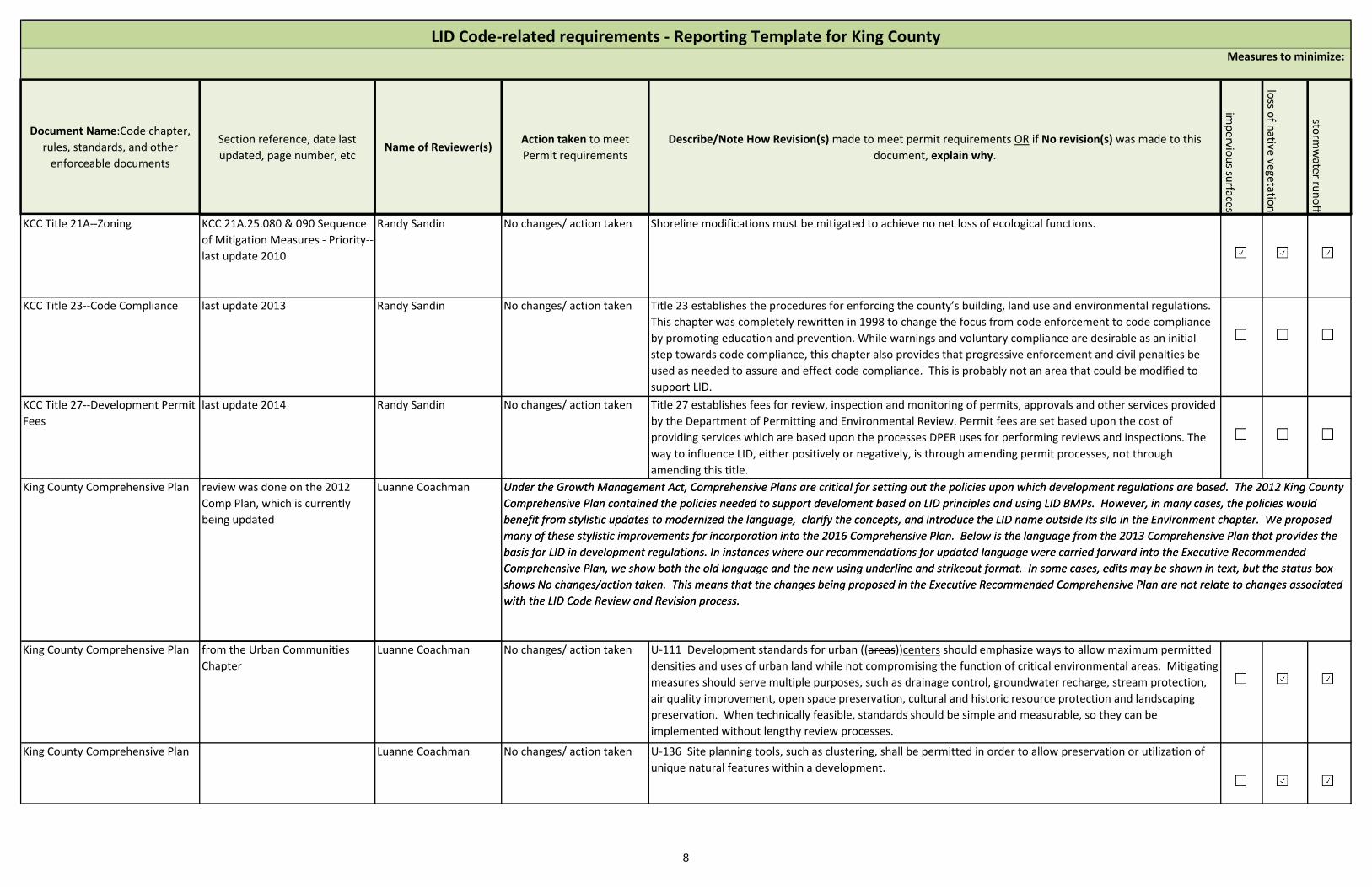
Document Name:Code chapter,
rules, standards, and other
enforceable documents
Section reference, date last
updated, page number, etcName of Reviewer(s)
Action taken to meet
Permit requirements
Describe/Note How Revision(s) made to meet permit requirements OR if No revision(s) was made to this
document, explain why.im
pervio
us su
rfaces
loss o
f native
vegetation
storm
water ru
no
ff
LID Code-related requirements - Reporting Template for King CountyMeasures to minimize:
KCC Title 21A--Zoning KCC 21A.25.080 & 090 Sequence
of Mitigation Measures - Priority--
last update 2010
Randy Sandin No changes/ action taken Shoreline modifications must be mitigated to achieve no net loss of ecological functions.
KCC Title 23--Code Compliance last update 2013 Randy Sandin No changes/ action taken Title 23 establishes the procedures for enforcing the county’s building, land use and environmental regulations.
This chapter was completely rewritten in 1998 to change the focus from code enforcement to code compliance
by promoting education and prevention. While warnings and voluntary compliance are desirable as an initial
step towards code compliance, this chapter also provides that progressive enforcement and civil penalties be
used as needed to assure and effect code compliance. This is probably not an area that could be modified to
support LID.
KCC Title 27--Development Permit
Fees
last update 2014 Randy Sandin No changes/ action taken Title 27 establishes fees for review, inspection and monitoring of permits, approvals and other services provided
by the Department of Permitting and Environmental Review. Permit fees are set based upon the cost of
providing services which are based upon the processes DPER uses for performing reviews and inspections. The
way to influence LID, either positively or negatively, is through amending permit processes, not through
amending this title.
Under the Growth Management Act, Comprehensive Plans are critical for setting out the policies upon which development regulations are based. The 2012 King County
Comprehensive Plan contained the policies needed to support develoment based on LID principles and using LID BMPs. However, in many cases, the policies would
benefit from stylistic updates to modernized the language, clarify the concepts, and introduce the LID name outside its silo in the Environment chapter. We proposed
many of these stylistic improvements for incorporation into the 2016 Comprehensive Plan. Below is the language from the 2013 Comprehensive Plan that provides the
basis for LID in development regulations. In instances where our recommendations for updated language were carried forward into the Executive Recommended
Comprehensive Plan, we show both the old language and the new using underline and strikeout format. In some cases, edits may be shown in text, but the status box
shows No changes/action taken. This means that the changes being proposed in the Executive Recommended Comprehensive Plan are not relate to changes associated
with the LID Code Review and Revision process.
King County Comprehensive Plan review was done on the 2012
Comp Plan, which is currently
being updated
Luanne Coachman Under the Growth Management Act, Comprehensive Plans are critical for setting out the policies upon which development regulations are based. The 2012 King County
Comprehensive Plan contained the policies needed to support develoment based on LID principles and using LID BMPs. However, in many cases, the policies would
benefit from stylistic updates to modernized the language, clarify the concepts, and introduce the LID name outside its silo in the Environment chapter. We proposed
many of these stylistic improvements for incorporation into the 2016 Comprehensive Plan. Below is the language from the 2013 Comprehensive Plan that provides the
basis for LID in development regulations. In instances where our recommendations for updated language were carried forward into the Executive Recommended
Comprehensive Plan, we show both the old language and the new using underline and strikeout format. In some cases, edits may be shown in text, but the status box
shows No changes/action taken. This means that the changes being proposed in the Executive Recommended Comprehensive Plan are not relate to changes associated
with the LID Code Review and Revision process.
King County Comprehensive Plan from the Urban Communities
Chapter
Luanne Coachman No changes/ action taken U-111 Development standards for urban ((areas))centers should emphasize ways to allow maximum permitted
densities and uses of urban land while not compromising the function of critical environmental areas. Mitigating
measures should serve multiple purposes, such as drainage control, groundwater recharge, stream protection,
air quality improvement, open space preservation, cultural and historic resource protection and landscaping
preservation. When technically feasible, standards should be simple and measurable, so they can be
implemented without lengthy review processes.
King County Comprehensive Plan Luanne Coachman No changes/ action taken U-136 Site planning tools, such as clustering, shall be permitted in order to allow preservation or utilization of
unique natural features within a development.
8
Document Name:Code chapter,
rules, standards, and other
enforceable documents
Section reference, date last
updated, page number, etcName of Reviewer(s)
Action taken to meet
Permit requirements
Describe/Note How Revision(s) made to meet permit requirements OR if No revision(s) was made to this
document, explain why.im
pervio
us su
rfaces
loss o
f native
vegetation
storm
water ru
no
ff
LID Code-related requirements - Reporting Template for King CountyMeasures to minimize:
King County Comprehensive Plan Luanne Coachman No changes/ action taken U-185 Through the Four to One Program, King County shall actively pursue dedication of open space along the
original Urban Growth Area line adopted in the 1994 King County Comprehensive Plan. Through this program,
one acre of Rural Area zoned land may be added to the Urban Growth Area in exchange for a dedication to King
County of four acres of permanent open space. Land added to the Urban Growth Area for ((naturally
appearing)) drainage facilities that are designed as mitigation to have a natural looking visual appearance in
support of its development, does not require dedication of permanent open space.
King County Comprehensive Plan Luanne Coachman No changes/ action taken
U-188 King County shall preserve the open space acquired through this program primarily as natural areas,
passive recreation sites or resource lands for farming or forestry. King County may allow the following
additional uses only if located on a small portion of the open space, provided that these uses are found to be
compatible with the site's natural open space values and functions such as those listed in the preceding policy:
a. Trails;
b. Compensatory mitigation of wetland losses on the urban designated portion of the project, consistent with
the King County Comprehensive Plan and the Critical Area Ordinance; and
c. Active recreation uses not to exceed five percent of the total open space area. Support services and facilities
for the active recreation uses may locate within the active recreation area only, and shall not exceed five
percent of the active recreation area. An active recreation area shall not be used to satisfy the active recreation
requirements for the urban designated portion of the project as required by K.C.C. Title 21A.
King County Comprehensive Plan from the Rural Areas and Natural
Resource Lands Chapter
Luanne Coachman No changes/ action taken
R-314 King County supports and shall work actively to facilitate the transfer of Rural Area and Natural Resource
Lands development rights to:
a. Preserve the rural environment, encourage retention of resource-based uses and reduce service demands;
b. Provide permanent protection to significant natural resources;
c. Increase the regional open space system;
d. Maintain low density development in the Rural Area and Natural Resource Lands;
e. Steer development growth inside the Urban Growth Area in ways that promote quality urban neighborhoods
where residents want to work and live; and
f. Provide mitigation for the impacts of urban development on global climate change by simultaneously reducing
transportation-related greenhouse gas emissions and sequestering carbon through retention of forest cover and
conserving agricultural lands through zoning, land use planning, transfer of development rights and similar tools.
9
Document Name:Code chapter,
rules, standards, and other
enforceable documents
Section reference, date last
updated, page number, etcName of Reviewer(s)
Action taken to meet
Permit requirements
Describe/Note How Revision(s) made to meet permit requirements OR if No revision(s) was made to this
document, explain why.im
pervio
us su
rfaces
loss o
f native
vegetation
storm
water ru
no
ff
LID Code-related requirements - Reporting Template for King CountyMeasures to minimize:
King County Comprehensive Plan Luanne Coachman Amend existing code R-336 King County shall continue to support the rural development standards that have been established to
protect the natural environment by addressing seasonal and maximum clearing limits, impervious surface limits
((, surface water management standards that emphasize preservation of natural drainage systems and water
quality, groundwater protection,))and resource-based practices.
((These standards should be designed to provide appropriate exceptions for lands that are to be developed for
kindergarten through twelfth grade public schools and school facilities, provided that the school project shall
comply at a minimum with the requirements of the King County Surface Water Design Manual.)) Stormwater
management practices should be implemented that emphasize preservation of natural drainage systems,
protect water quality and natural hydrology of surface waters and groundwater. Rural development standards
should also, where feasible, incorporate and encourage Low Impact Design principles for managing stormwater
onsite by minimizing impervious surfaces, preserving onsite hydrology, retaining native vegetation and forest
cover, capturing and reusing rainwater, controlling pollution at the source, and protecting groundwater. King
County shall take care that requirements for onsite stormwater management complement requirements for
onsite wastewater management.
10
Document Name:Code chapter,
rules, standards, and other
enforceable documents
Section reference, date last
updated, page number, etcName of Reviewer(s)
Action taken to meet
Permit requirements
Describe/Note How Revision(s) made to meet permit requirements OR if No revision(s) was made to this
document, explain why.im
pervio
us su
rfaces
loss o
f native
vegetation
storm
water ru
no
ff
LID Code-related requirements - Reporting Template for King CountyMeasures to minimize:
King County Comprehensive Plan from the Environment Chapter Luanne Coachman Amend existing code From the intro to the Environment Chapter:
New approaches for stormwater management ((that mimic the natural functions of soil and forest cover in
slowing and filtering stormwater runoff,)) known as Low Impact Development (LID)((techniques)), are providing
additional options for stormwater management, especially in site development. ((In conjunction with a
comprehensive stormwater management program of structural controls and best management practices, LID
techniques can result in reduced impacts from stormwater runoff and protection of the ecological functions of
the landscape and surface waters. LID techniques work in tandem with structural controls and other best
management practices to meet other objectives such as retention of canopy cover, riparian habitat and native
soils that help protect biodiversity, improve air quality, and create a better and more sustainable environment
and quality of life for King County citizens.)) Low Impact Development Best Management Practices can mimic
the natural functions of soil and forest cover in slowing and filtering stormwater runoff by infiltrating or
dispersing stormwater onsite, or by capturing and reusing it. Used exclusively, or in conjunction with a
comprehensive stormwater management program of structural controls and other best management practices,
Low Impact Development Best Management Practices can reduce environmental impacts from stormwater
runoff. Low Impact Development techniques also work in tandem with other strategies like retaining forest
cover, preserving native plants and preserving native soil.
These techniques help to meet other objectives such as retention of canopy cover, protection of riparian habitat
and preservation of native soils that help protect biodiversity, improve air quality, and protect the ecological
functions of the landscape and surface waters. These approaches help create a more sustainable environment
and create a better quality of life for King County residents.
11

Document Name:Code chapter,
rules, standards, and other
enforceable documents
Section reference, date last
updated, page number, etcName of Reviewer(s)
Action taken to meet
Permit requirements
Describe/Note How Revision(s) made to meet permit requirements OR if No revision(s) was made to this
document, explain why.im
pervio
us su
rfaces
loss o
f native
vegetation
storm
water ru
no
ff
LID Code-related requirements - Reporting Template for King CountyMeasures to minimize:
King County Comprehensive Plan From the Stormwater Quality
section of the Environment
Chapter
Doug Navetski, Luanne
Coachman
Amend existing code Rivers, streams, lakes, wetlands, and groundwater must be protected from the adverse impacts of
((urbanization))development and land use change to continue functioning in a beneficial manner. Because
((urbanization))development both increases runoff from storms and reduces streamflows in dry months by
limiting infiltration, control of the ((quantity))rate, volume and quality of stormwater runoff is critical.
Unmitigated stormwater runoff can cause erosion, sedimentation and flooding with resulting adverse impacts
on water quality, fish and wildlife habitat, property and human safety. In addition, stormwater runoff can carry
pollutants such as oil, heavy metals, fertilizers, herbicides, pesticides and animal wastes into waters.
Sedimentation from soil disturbed by clearing, grading, farming and logging can reduce river or stream channel
capacity, fill lakes and wetlands, and smother aquatic life and habitat.
King County stormwater management encompasses a wide range of ((programs))strategies that integrate
proven, traditional approaches with new and innovative concepts, such as low impact development (LID)
practices intended to ((minimize pollutants and mimic the natural flow of stormwater runoff))manage
stormwater runoff onsite, reducing discharges of pollutants in stormwater runoff, and mimicking natural
hydrology.
King County Comprehensive Plan ((These programs and practices include such actions as changing land use and development practices;
encouraging public behaviors through education and social marketing that maximize natural hydrologic
processes; improving pollution source control by legislating product or material restrictions; changing business
practices and educating the public about pollution generating activities; implementing programs that minimize
land clearing and preserve or restore native vegetation; housing clustering and smart growth to reduce
development impacts and the construction and maintenance of conveyance; and flow control (detention or
infiltration) and water quality treatment facilities and their associated drainage systems. Together these
programs and practices will reduce pollution and flow impacts in King County’s surface and ground waters.))
King County Comprehensive Plan King County's stormwater management strategies include but are not limited to encouraging an approach to site
development that includes clustering or smart growth, minimizes impervious surfaces, and maximizes the
amount of native plants and soils; using education and social marketing to increase the public’s awareness of
water quality issues and encourage behaviors that support water quality; improving pollution source control by
legislating product or material restrictions; improving business practices by educating business owners and
operators about pollution generating activities and best management practices to mitigate them; and
constructing and maintaining an stormwater infrastructure system that controls, conveys and treats stormwater
runoff. Together these strategies will reduce pollution and flow impacts of stormwater runoff on King County’s
surface and ground waters.
12
Document Name:Code chapter,
rules, standards, and other
enforceable documents
Section reference, date last
updated, page number, etcName of Reviewer(s)
Action taken to meet
Permit requirements
Describe/Note How Revision(s) made to meet permit requirements OR if No revision(s) was made to this
document, explain why.im
pervio
us su
rfaces
loss o
f native
vegetation
storm
water ru
no
ff
LID Code-related requirements - Reporting Template for King CountyMeasures to minimize:
King County Comprehensive Plan
((King County supports the implementation of new approaches such as low impact development (LID) best
management practices (BMPs) techniques as part of a comprehensive stormwater management program. LID
requires the public to maintain stormwater features on their properties, including but not limited to rain
gardens, dispersion areas, permeable pavement driveways, and vegetated roofs. As with any new approach or
technology, the effectiveness and limitations of LID practices must be determined. These evolving technologies
need to be studied further to determine operational effectiveness, long term maintenance needs, and
appropriate placement.)) As required by the National Pollution Discharge Elimination System (NPDES) Phase I
Municipal Stormwater Permit, King County is making low impact development the preferred and commonly
used approach to site development. As a result of using the low impact development approach, an increasing
number of stormwater management best management practices including, but not limited to, rain gardens,
dispersion, permeable driveways and walkways, vegetated roofs, and the capture and reuse of rainwater, will be
constructed on private property and will rely on private maintenance for their continuing function.
King County Comprehensive Plan
((Some stormwater practices require changes in how we live and work on the land. Successful implementation
will include different product use, new land development approaches, and, in some areas, the setting aside of
private land and its dedication to stormwater purposes. In addition, effective stormwater management will
require a regional approach that includes landscape level analysis to identify areas of greatest need for
additional management including retrofitting older developed areas and constructing facilities where no or
minimal management exists now.)) In addition to the stormwater strategies discussed above, as well as those
discussed in Chapter 8: Transportation , effective stormwater management will require a basin or sub‑basin
approaches that identifies areas that were built out under old or nonexistent stormwater design standards.
Basins where deficiencies in flow control or water quality are identified would be prioritized to correct those
deficiencies. These retrofits could include upgrades to existing stormwater management structures or the
placement of new ones, including onsite low impact development best management practices like bioretention
or raingardens, or the replacement of impervious pavement with permeable.
King County Comprehensive Plan Long term stormwater management strategies may require changes in how people live and work on the land.
Approaches could include using different products (green products), implementing new land development
approaches such as cluster housing, and, in some areas, the setting aside of land and its dedication to riparian
habitat, and maintaining natural vegetation.
King County Comprehensive Plan E-445 Stormwater runoff shall be managed through a variety of methods, with the goal of protecting surface
water quality, in stream flows, and aquatic habitat; promoting groundwater recharge while protecting
groundwater quality; reducing the risk of flooding; protecting public safety and properties; and enhancing the
viability of agricultural lands.
13
Document Name:Code chapter,
rules, standards, and other
enforceable documents
Section reference, date last
updated, page number, etcName of Reviewer(s)
Action taken to meet
Permit requirements
Describe/Note How Revision(s) made to meet permit requirements OR if No revision(s) was made to this
document, explain why.im
pervio
us su
rfaces
loss o
f native
vegetation
storm
water ru
no
ff
LID Code-related requirements - Reporting Template for King CountyMeasures to minimize:
King County Comprehensive Plan from the Forest Cover section of
the Environment Chapter
Luanne Coachman No changes/ action taken E-447 King County recognizes that ((protecting))conserving and restoring headwater and upland forest cover is
important for preventing flooding, improving water quality, and protecting salmon and other wildlife habitat.
The central role that forest cover plays in supporting hydrologic and other ecological processes should be
reflected in policies and programs addressing stormwater management, flooding, wildlife, and open space.
King County Comprehensive Plan Luanne Coachman No changes/ action taken E-448 King County’s critical areas and clearing and grading regulations should provide for activities compatible
with long term forest use, including use of recreational trails, firewood collection, forest fire prevention, forest
management, and control of invasive plants.
King County Comprehensive Plan Luanne Coachman No changes/ action taken E-449 ((The county))King County shall promote retention of forest cover and significant trees using a mix of
regulations, incentives, and technical assistance.
King County Comprehensive Plan from the Soils and Organics
section of the Environment
Chapter
Luanne Coachman No changes/ action taken E-450 Site development practices should minimize soil disturbance and maximize retention of native vegetation
and soils. Where soil disturbance is unavoidable, native soils should be stockpiled on site and reused on site in
accordance with best management practices to the maximum extent ((possible)) practicable.
King County Comprehensive Plan Luanne Coachman No changes/ action taken E-451 King County shall require the use of organic matter to restore disturbed soils on site developments.
Luanne Coachman No changes/ action taken E-456 King County shall promote, encourage, and require, where appropriate, the beneficial use of organic
materials, including but not limited to their use in the following activities: agriculture and silviculture; road, park
and other public project development; site development and new construction; restoration and remediation of
disturbed soils; nursery and sod production; and landscaping. For these purposes, organic materials do not
include fly ash.
Luanne Coachman No changes/ action taken E-458 King County will seek to enhance soil quality, and protect water quality and biodiversity across the
landscape by developing policies, programs, and incentives that support the goal of no net loss of organic
material.
King County Comprehensive Plan from the Wetlands section of the
Environment Chapter
Luanne Coachman No changes/ action taken E-475 Areas of native vegetation that connect wetland complexes should be protected. Whenever effective,
incentive programs such as buffer averaging, density credit transfers, or appropriate non-regulatory mechanisms
shall be used for this purpose.
14

Document Name:Code chapter,
rules, standards, and other
enforceable documents
Section reference, date last
updated, page number, etcName of Reviewer(s)
Action taken to meet
Permit requirements
Describe/Note How Revision(s) made to meet permit requirements OR if No revision(s) was made to this
document, explain why.im
pervio
us su
rfaces
loss o
f native
vegetation
storm
water ru
no
ff
LID Code-related requirements - Reporting Template for King CountyMeasures to minimize:
King County Comprehensive Plan Luanne Coachman No changes/ action taken E-476 King County should identify upland areas of native vegetation that connect wetlands to upland habitats
and that connect upland habitats to each other. The county should seek protection of these areas through
acquisition, stewardship plans, and incentive programs such as the Public Benefit Rating System and the Transfer
of Development Rights Program.
King County Comprehensive Plan Luanne Coachman No changes/ action taken E-477 The unique hydrologic cycles, soil and water chemistries, and vegetation communities of bogs and fens
shall be protected through the use of incentives, acquisition, best management practices, and implementation
of the King County Surface Water Design Manual to control and/or treat stormwater within the wetland
watershed.
King County Comprehensive Plan from the Groundwater Resouces
section of the Environment
Chapter
Luanne Coachman No changes/ action taken E-494 King County should protect the quality and quantity of groundwater countywide by: ... c.
Developing, with affected jurisdictions, best management practices for development and for forestry,
agriculture, and mining operations based on adopted Groundwater Management Plans and Wellhead Protection
Programs. The goals of these practices should be to promote aquifer recharge quality and to strive for no net
reduction of recharge to groundwater quantity;... f. Encouraging forest retention
and active forest stewardship;
g. Incorporating into its land use and water service decisions consideration of potential impacts on groundwater
quality and quantity, and the need for long-term aquifer protection; ...
King County Comprehensive Plan Luanne Coachman No changes/ action taken E-495 King County should protect groundwater recharge quantity by promoting low impact development and
other methods that infiltrate stormwater runoff where site conditions permit and where pollution source
controls and stormwater treatment can prevent potential groundwater contamination.
King County Comprehensive Plan Luanne Coachman No changes/ action taken E-497 King County should protect groundwater in the Rural Area by:
King County should protect groundwater in the Rural Area by:
a. Preferring land uses that retain a high ratio of permeable to impermeable surface area, and that maintain
and/or augment the natural soil’s infiltration capacity and treatment capability for groundwater; ((and))
b. Requiring risk assessments and monitoring, where appropriate, of rural potable water supplies in
groundwater subareas, and coordinate findings with local and state governments, agencies, districts and local
property owners to monitor potable water supplies at high risk and develop plans to mitigate for the loss or
serious impairment of domestic water supply from wells and springs; and
c. Requiring standards for maximum vegetation clearing limits, impervious surface limits, and, where
appropriate, infiltration of surface water.
15
Document Name:Code chapter,
rules, standards, and other
enforceable documents
Section reference, date last
updated, page number, etcName of Reviewer(s)
Action taken to meet
Permit requirements
Describe/Note How Revision(s) made to meet permit requirements OR if No revision(s) was made to this
document, explain why.im
pervio
us su
rfaces
loss o
f native
vegetation
storm
water ru
no
ff
LID Code-related requirements - Reporting Template for King CountyMeasures to minimize:
King County Comprehensive Plan from the Rivers and Streams
section of the Environment
Chapter
Luanne Coachman No changes/ action taken E-499e To maintain and restore stream health, sources of uncontrolled stormwater flows contributing to peak
flows in small streams should be managed using on-site structural or non-structural flow control techniques.
King County Comprehensive Plan from the Watershed-Based
Salmon Recovery section of the
Environment Chapter
Luanne Coachman No changes/ action taken E-499l King County should seek to support Water Resource Inventory Area salmon recovery plan goals of
maintaining intact natural landscapes through:
a. Retaining low density land use designations such as Agriculture, Forestry and Rural Area designations;
b. Promoting Current Use Taxation and other incentives;
c. Promoting stewardship programs including development and implementation of Forest Plans, Farm Plans, and
Rural Stewardship Plans;
d. Promoting the use of Low Impact Development methods; and
e. Acquiring property or conservation easements in areas of high ecological importance with unique or
otherwise significant habitat values.
King County Comprehensive Plan from the Erosion Hazard Areas
section of the Environment
Chapter
Luanne Coachman No changes/ action taken E-502 Land uses permitted in Erosion Hazard Areas shall minimize soil disturbance and should maximize
retention and replacement of native vegetative cover.
King County Comprehensive Plan Luanne Coachman No changes/ action taken E-504 King County should protect native plant communities by encouraging management and control of
nonnative invasive plants, including aquatic plants. Environmentally sound methods of vegetation control
should be used to control noxious weeds.
King County Comprehensive Plan Luanne Coachman No changes/ action taken E-506 The use of native plants should be encouraged in landscaping requirements and erosion control projects,
and in the restoration of stream banks, lakes, shorelines, and wetlands.
King County Comprehensive Plan from the Conservancy Shoreline
section of the Shorelines Chapter
Luanne Coachman No changes/ action taken S-517 King County shall require that new uses or development in the Conservancy Shoreline Environment
preserve the existing character of the shoreline consistent with the purpose of the environment, including:
a. Limiting the total effective impervious surface in the shoreline jurisdiction to no more than ten percent in
order to maintain the existing hydrologic character of the site; and
b. Allowing more effective impervious surface coverage on lots legally created prior to the date of adoption of
this update to King County’s Shoreline Master Program. In these cases, effective impervious surface coverage
shall be limited to the maximum extent practicable.
16
Document Name:Code chapter,
rules, standards, and other
enforceable documents
Section reference, date last
updated, page number, etcName of Reviewer(s)
Action taken to meet
Permit requirements
Describe/Note How Revision(s) made to meet permit requirements OR if No revision(s) was made to this
document, explain why.im
pervio
us su
rfaces
loss o
f native
vegetation
storm
water ru
no
ff
LID Code-related requirements - Reporting Template for King CountyMeasures to minimize:
King County Comprehensive Plan from the Natural Shoreline
section of the Shorelines Chapter
Luanne Coachman No changes/ action taken S-530 Except for removal of noxious weeds or invasive vegetation as provided for in S 645, King County shall not
allow vegetation removal in the Natural Shoreline Environment that will reduce the capability of vegetation to
perform normal ecological processes and functions.
King County Comprehensive Plan from the Vegetation
Conservation section of the
Shorelines Chapter
Luanne Coachman No changes/ action taken S-640 King County shall adopt planning provisions to address vegetation conservation and restoration and
regulatory provisions to address conservation of vegetation, as necessary, to assure no net loss of shoreline
ecological processes and functions, to avoid adverse impacts to soil hydrology, and to reduce the hazard of slope
failures or accelerated erosion.
King County Comprehensive Plan Luanne Coachman No changes/ action taken S-641 Vegetation conservation provisions apply to all shoreline uses and developments, whether or not the use
or development requires a shoreline substantial development permit.
King County Comprehensive Plan Luanne Coachman No changes/ action taken S-643 King County should identify which ecological processes and functions are important to the local aquatic
and terrestrial ecology, and then conserve sufficient vegetation to maintain these functions. Vegetation
conservation areas are not necessarily intended to be closed to use and development, but should provide for
management of vegetation in a manner adequate to assure no net loss of shoreline ecological processes and
functions.
King County Comprehensive Plan Luanne Coachman No changes/ action taken S-644 King County should adopt development regulations for vegetated areas along streams, which once
supported or could in the future support mature trees, that include buffers of sufficient width to facilitate the
growth of mature trees and periodic recruitment of woody vegetation into the water body to support
vegetation related shoreline functions.
King County Comprehensive Plan Luanne Coachman No changes/ action taken S-645 King County should adopt mechanisms to implement the vegetation conservation policies of this chapter.
These mechanisms may include setback or buffer requirements, clearing and grading standards, regulatory
incentives, environment designation standards, or other provisions. Selective pruning of trees for safety and
view protection may be allowed. Removal of noxious weeds and invasive vegetation should be allowed as long
as appropriate best management practices are followed.
King County Comprehensive Plan from the Water Quality,
Stormwater and Non-Point
Pollution section of the
Shorelines Chapter
Luanne Coachman No changes/ action taken S-648 King County should ensure mutual consistency between shoreline management provisions and other
regulations that address water quality and stormwater quantity, including Public Health—Seattle & King County
standards, the King County Surface Water Design Manual, and King County surface water management
regulations. The regulations that are most protective of ecological functions shall apply.
17

Document Name:Code chapter,
rules, standards, and other
enforceable documents
Section reference, date last
updated, page number, etcName of Reviewer(s)
Action taken to meet
Permit requirements
Describe/Note How Revision(s) made to meet permit requirements OR if No revision(s) was made to this
document, explain why.im
pervio
us su
rfaces
loss o
f native
vegetation
storm
water ru
no
ff
LID Code-related requirements - Reporting Template for King CountyMeasures to minimize:
King County Comprehensive Plan from the Transportation and
Parking section of the Shorelines
Chapter
Luanne Coachman No changes/ action taken S-759 Parking facilities in the shoreline jurisdiction are not a preferred use. King County shall allow parking
facilities in the shoreline jurisdiction only when necessary to support an authorized use and when an alternatives
analysis shows there are no feasible alternatives outside of the 200 ft shoreline jurisdiction. Parking facilities in
the shoreline jurisdiction shall use Low Impact Designs, such as porous concrete and vegetated swales, and be
planned, located and designed to minimize the environmental and visual impacts.
King County Comprehensive Plan from the Regional Open Space
System section of the Parks,
Open Space, and Cultural
Resources Chapter
Luanne Coachman No changes/ action taken P-102 King County shall be a regional leader in the provision of a regional open space system consisting of
parks, regional trails, natural areas, ((working))natural resource lands, and flood hazard management lands. The
regional network of open spaces provides benefits to all county residents including: recreation facilities,
conservation of natural and working resource lands, improving air and water quality, flood hazard management
and related programs and services, thereby contributing to the physical, mental and emotional well being of
county residents.
King County Comprehensive Plan Luanne Coachman No changes/ action taken P-103 King County will preserve wildlife corridors, ((and)) riparian habitat, contiguous forest land, as well as
open space areas separating Urban and Rural Areas as part of its open space system.
King County Comprehensive Plan from the Natural Areas section of
the Parks, Open Space, and
Cultural Resources Chapter
Luanne Coachman No changes/ action taken P-111 King County will manage its natural areas to protect, preserve and enhance important natural resource
habitat, biological diversity, and the ecological integrity of natural systems.
King County Comprehensive Plan Luanne Coachman No changes/ action taken P-112 King County shall recognize and protect the natural character and ecological value of its natural areas.
These areas are important for preserving fish and wildlife and their habitat, native vegetation, and features of
scientific and educational value. Development and public use may be limited to preserve the natural state and
reduce disturbance of the natural resources. Site improvements should be focused on providing educational
and interpretive opportunities. Public access should be directed to the less fragile portions of a site to ensure
continued protection of the ecological resources.
King County Comprehensive Plan from the Forestland section of
the Parks, Open Space, and
Cultural Resources Chapter
Luanne Coachman No changes/ action taken P-116 ((F))Working forest land and conservation easements owned by King County shall provide large tracts of
forested property in the Rural Forest Focus Areas, ((and)) the Forest Production District (FPD) and Rural Area
that will remain in active forestry, protect areas from development or provide a buffer between commercial
forestland and adjacent residential development.
18
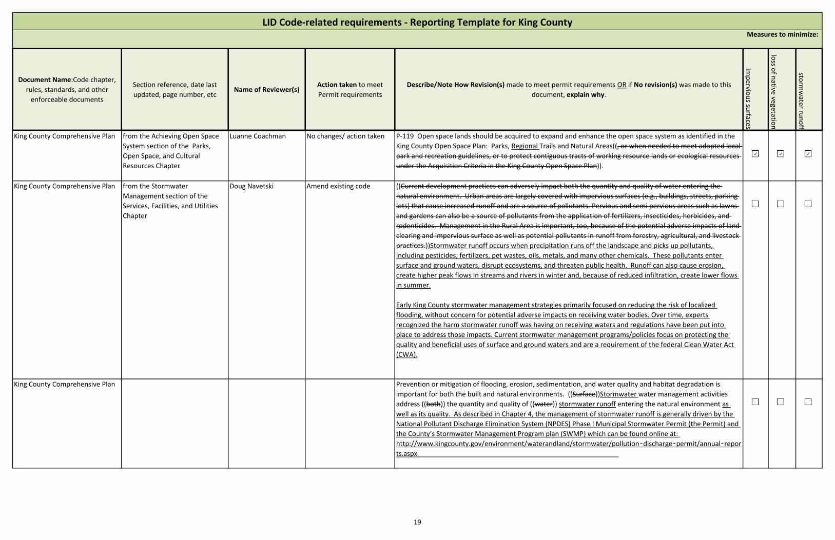
Document Name:Code chapter,
rules, standards, and other
enforceable documents
Section reference, date last
updated, page number, etcName of Reviewer(s)
Action taken to meet
Permit requirements
Describe/Note How Revision(s) made to meet permit requirements OR if No revision(s) was made to this
document, explain why.im
pervio
us su
rfaces
loss o
f native
vegetation
storm
water ru
no
ff
LID Code-related requirements - Reporting Template for King CountyMeasures to minimize:
King County Comprehensive Plan from the Achieving Open Space
System section of the Parks,
Open Space, and Cultural
Resources Chapter
Luanne Coachman No changes/ action taken P-119 Open space lands should be acquired to expand and enhance the open space system as identified in the
King County Open Space Plan: Parks, Regional Trails and Natural Areas((, or when needed to meet adopted local
park and recreation guidelines, or to protect contiguous tracts of working resource lands or ecological resources
under the Acquisition Criteria in the King County Open Space Plan)).
King County Comprehensive Plan from the Stormwater
Management section of the
Services, Facilities, and Utilities
Chapter
Doug Navetski Amend existing code ((Current development practices can adversely impact both the quantity and quality of water entering the
natural environment. Urban areas are largely covered with impervious surfaces (e.g., buildings, streets, parking
lots) that cause increased runoff and are a source of pollutants. Pervious and semi pervious areas such as lawns
and gardens can also be a source of pollutants from the application of fertilizers, insecticides, herbicides, and
rodenticides. Management in the Rural Area is important, too, because of the potential adverse impacts of land
clearing and impervious surface as well as potential pollutants in runoff from forestry, agricultural, and livestock
practices.))Stormwater runoff occurs when precipitation runs off the landscape and picks up pollutants,
including pesticides, fertilizers, pet wastes, oils, metals, and many other chemicals. These pollutants enter
surface and ground waters, disrupt ecosystems, and threaten public health. Runoff can also cause erosion,
create higher peak flows in streams and rivers in winter and, because of reduced infiltration, create lower flows
in summer.
Early King County stormwater management strategies primarily focused on reducing the risk of localized
flooding, without concern for potential adverse impacts on receiving water bodies. Over time, experts
recognized the harm stormwater runoff was having on receiving waters and regulations have been put into
place to address those impacts. Current stormwater management programs/policies focus on protecting the
quality and beneficial uses of surface and ground waters and are a requirement of the federal Clean Water Act
(CWA).
King County Comprehensive Plan Prevention or mitigation of flooding, erosion, sedimentation, and water quality and habitat degradation is
important for both the built and natural environments. ((Surface))Stormwater water management activities
address ((both)) the quantity and quality of ((water)) stormwater runoff entering the natural environment as
well as its quality. As described in Chapter 4, the management of stormwater runoff is generally driven by the
National Pollutant Discharge Elimination System (NPDES) Phase I Municipal Stormwater Permit (the Permit) and
the County’s Stormwater Management Program plan (SWMP) which can be found online at:
http://www.kingcounty.gov/environment/waterandland/stormwater/pollution‑discharge‑permit/annual‑repor
ts.aspx
19
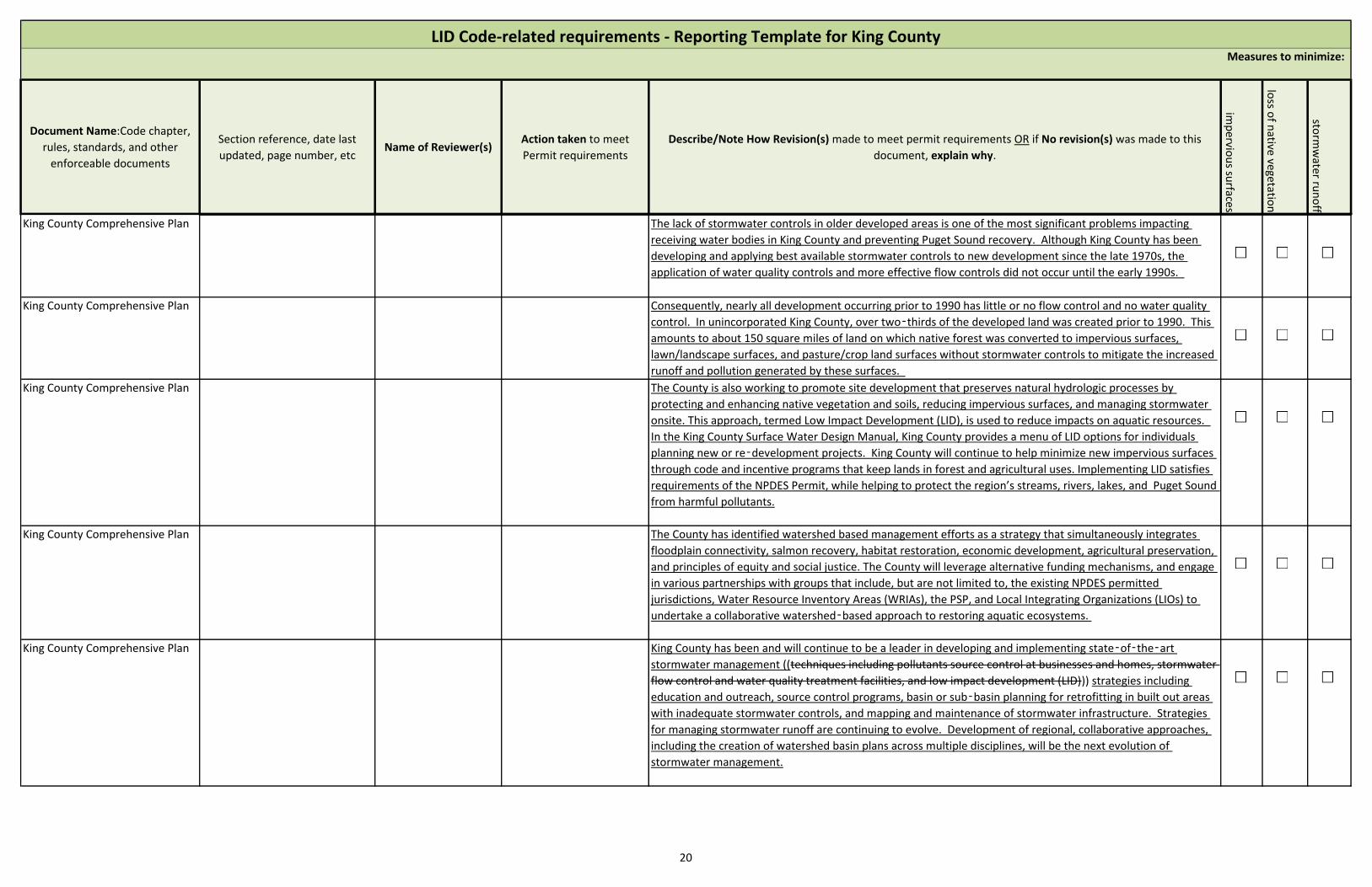
Document Name:Code chapter,
rules, standards, and other
enforceable documents
Section reference, date last
updated, page number, etcName of Reviewer(s)
Action taken to meet
Permit requirements
Describe/Note How Revision(s) made to meet permit requirements OR if No revision(s) was made to this
document, explain why.im
pervio
us su
rfaces
loss o
f native
vegetation
storm
water ru
no
ff
LID Code-related requirements - Reporting Template for King CountyMeasures to minimize:
King County Comprehensive Plan The lack of stormwater controls in older developed areas is one of the most significant problems impacting
receiving water bodies in King County and preventing Puget Sound recovery. Although King County has been
developing and applying best available stormwater controls to new development since the late 1970s, the
application of water quality controls and more effective flow controls did not occur until the early 1990s.
King County Comprehensive Plan Consequently, nearly all development occurring prior to 1990 has little or no flow control and no water quality
control. In unincorporated King County, over two‑thirds of the developed land was created prior to 1990. This
amounts to about 150 square miles of land on which native forest was converted to impervious surfaces,
lawn/landscape surfaces, and pasture/crop land surfaces without stormwater controls to mitigate the increased
runoff and pollution generated by these surfaces.
King County Comprehensive Plan The County is also working to promote site development that preserves natural hydrologic processes by
protecting and enhancing native vegetation and soils, reducing impervious surfaces, and managing stormwater
onsite. This approach, termed Low Impact Development (LID), is used to reduce impacts on aquatic resources.
In the King County Surface Water Design Manual, King County provides a menu of LID options for individuals
planning new or re‑development projects. King County will continue to help minimize new impervious surfaces
through code and incentive programs that keep lands in forest and agricultural uses. Implementing LID satisfies
requirements of the NPDES Permit, while helping to protect the region’s streams, rivers, lakes, and Puget Sound
from harmful pollutants.
King County Comprehensive Plan The County has identified watershed based management efforts as a strategy that simultaneously integrates
floodplain connectivity, salmon recovery, habitat restoration, economic development, agricultural preservation,
and principles of equity and social justice. The County will leverage alternative funding mechanisms, and engage
in various partnerships with groups that include, but are not limited to, the existing NPDES permitted
jurisdictions, Water Resource Inventory Areas (WRIAs), the PSP, and Local Integrating Organizations (LIOs) to
undertake a collaborative watershed‑based approach to restoring aquatic ecosystems.
King County Comprehensive Plan King County has been and will continue to be a leader in developing and implementing state‑of‑the‑art
stormwater management ((techniques including pollutants source control at businesses and homes, stormwater
flow control and water quality treatment facilities, and low impact development (LID))) strategies including
education and outreach, source control programs, basin or sub‑basin planning for retrofitting in built out areas
with inadequate stormwater controls, and mapping and maintenance of stormwater infrastructure. Strategies
for managing stormwater runoff are continuing to evolve. Development of regional, collaborative approaches,
including the creation of watershed basin plans across multiple disciplines, will be the next evolution of
stormwater management.
20

Document Name:Code chapter,
rules, standards, and other
enforceable documents
Section reference, date last
updated, page number, etcName of Reviewer(s)
Action taken to meet
Permit requirements
Describe/Note How Revision(s) made to meet permit requirements OR if No revision(s) was made to this
document, explain why.im
pervio
us su
rfaces
loss o
f native
vegetation
storm
water ru
no
ff
LID Code-related requirements - Reporting Template for King CountyMeasures to minimize:
King County Comprehensive Plan ((LID is an approach to land development that works to preserve a site’s natural hydrological functions by
protecting and enhancing native vegetation and soils, reducing impervious surface and managing stormwater at
the sources. Similarly, King County also encourages the use of low‑impact site design techniques to reduce
impacts to aquatic resources. These techniques, where feasible, are well suited to development in rural
residential zoned areas. LID is becoming an increasingly valuable tool for controlling polluted runoff that
contributes to declining populations of federally protected aquatic species, meeting the requirements of the
National Pollution Discharge Elimination System Municipal Stormwater Permit, and protecting and restoring the
region’s stream’s, river and lakes and the Puget Sound.))
King County Comprehensive Plan ((The primary LID tools to be used in the Rural Area are forest retention and limiting impervious surface. King
County shall continue to help limit impervious surface through code and incentive programs that help keep land
in forest and agricultural use.))
King County Comprehensive Plan F-272 To reduce flooding, erosion and sedimentation, prevent and mitigate habitat loss, enhance groundwater
recharge and prevent groundwater and surface water quality degradation, and promote the goals of the Growth
Management Act, ((the surface waters of)) King County shall ((be)) managed stormwater through plans,
programs and regulations developed by King County in cooperation with affected jurisdictions and agencies
whenever possible.
King County Comprehensive Plan F-273 A watershed approach shall be taken ((to surface))for stormwater management, with responsibility
shared ((among))between King County and affected jurisdictions. This approach should emphasize prevention of
((water quality))surface water and groundwater degradation through education programs, retrofits of existing
stormwater controls or the placement of new controls, and implementation of best management practices to
reduce pollution entering the region’s groundwater and surface waters, including Puget Sound.
King County Comprehensive Plan F-274 In the Rural Area, King County shall minimize the use of constructed facilities for ((surface
water))stormwater management and, through Low Impact Development, maximize the use of natural systems,
provided that the ecological functions of the natural systems are not harmed. The county should provide
incentives to keep these natural systems intact. ((Natural systems are also))Low Impact Development is also
preferred in the Urban Growth Area, but it is recognized that structural systems ((will))may be needed to realize
urban growth and density goals in these areas.
King County Comprehensive Plan F-278 King County shall continue to encourage, support and require the use of low impact development as a
part of its strategy to mitigate stormwater impacts from new development to the maximum extent feasible.
21
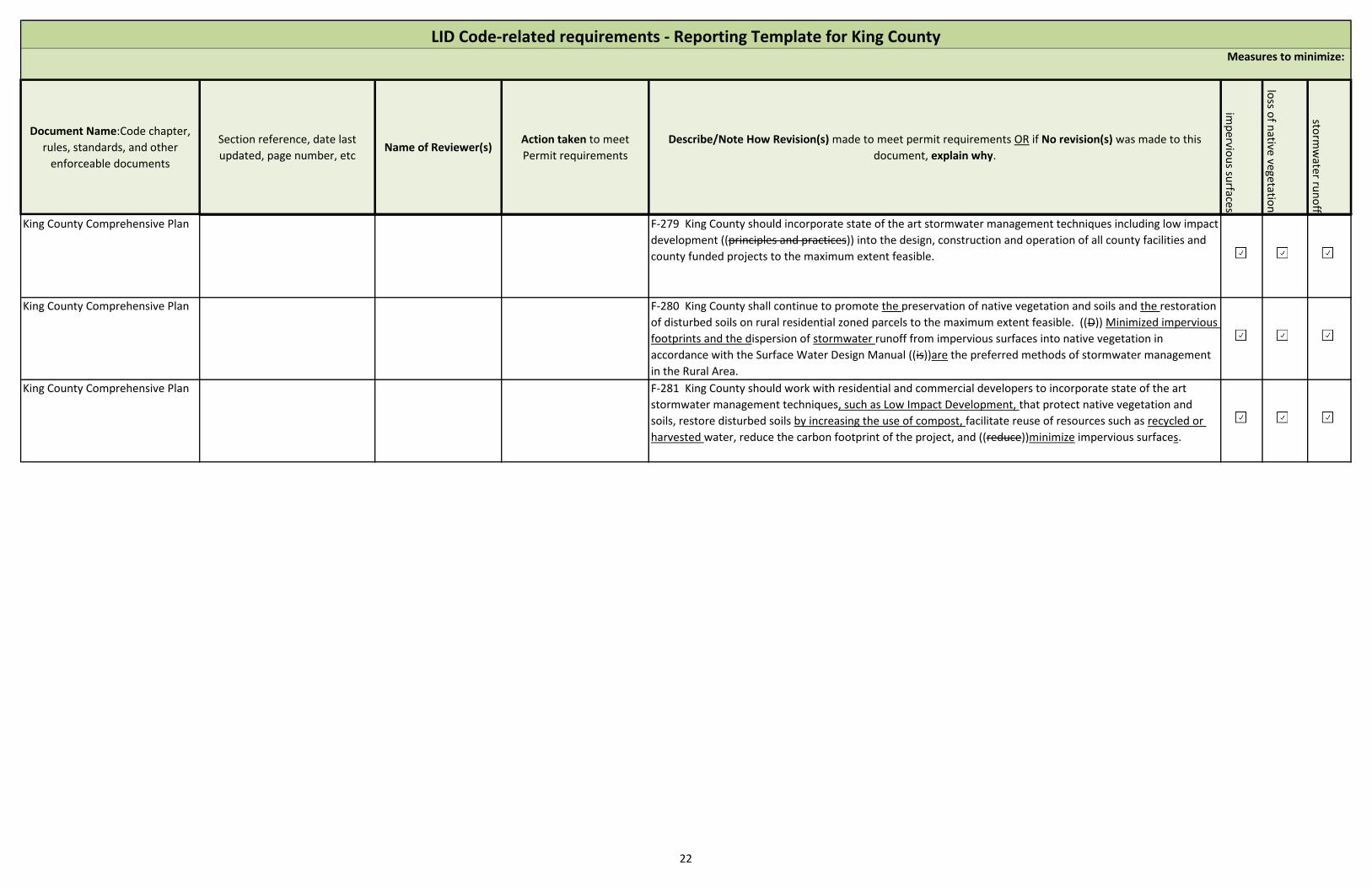
Document Name:Code chapter,
rules, standards, and other
enforceable documents
Section reference, date last
updated, page number, etcName of Reviewer(s)
Action taken to meet
Permit requirements
Describe/Note How Revision(s) made to meet permit requirements OR if No revision(s) was made to this
document, explain why.im
pervio
us su
rfaces
loss o
f native
vegetation
storm
water ru
no
ff
LID Code-related requirements - Reporting Template for King CountyMeasures to minimize:
King County Comprehensive Plan F-279 King County should incorporate state of the art stormwater management techniques including low impact
development ((principles and practices)) into the design, construction and operation of all county facilities and
county funded projects to the maximum extent feasible.
King County Comprehensive Plan F-280 King County shall continue to promote the preservation of native vegetation and soils and the restoration
of disturbed soils on rural residential zoned parcels to the maximum extent feasible. ((D)) Minimized impervious
footprints and the dispersion of stormwater runoff from impervious surfaces into native vegetation in
accordance with the Surface Water Design Manual ((is))are the preferred methods of stormwater management
in the Rural Area.
King County Comprehensive Plan F-281 King County should work with residential and commercial developers to incorporate state of the art
stormwater management techniques, such as Low Impact Development, that protect native vegetation and
soils, restore disturbed soils by increasing the use of compost, facilitate reuse of resources such as recycled or
harvested water, reduce the carbon footprint of the project, and ((reduce))minimize impervious surfaces.
22

Attachment 2015 Annual Report Question #13:
Describe in comments field opportunities created for the [public to participate in
the decision making processes involving the development, implementation and
updates of the SWMP (S5.C.4.a).

2.1.4 Public Involvement and Participation – S5.C.4
As part of the annual update process, King County invites public comment on the contents of the SWMP Plan. King County will advertise the comment period through its website (www.kingcounty.gov/environment/wlr/sections-programs/stormwater-services-section/stormwater-program/public-review.aspx) and email notifications sent to thousands of potentially interested parties through established distribution lists. All feedback received during the public comment period will be reviewed and considered prior to finalization of the SWMP Plan.
In addition to input received during the SWMP Plan public comment period, King County welcomes feedback year round. Comments may be emailed to [email protected] or mailed to Stormwater Management Team, King County Dept. of Natural Resources and Parks, 601 S. Jackson St., Suite 600, Seattle, WA 98104.
King County also engages the public in decision-making processes when it comes to siting, construction, and maintenance of County-initiated capital projects.
No later than March 31st of each year beginning in 2015, King County will post its updated SWMP Plan online at www.kingcounty.gov/environment/wlr/sections-programs/stormwater-services-section/stormwater-program.aspx. Other submittals related to the Municipal Permit are available upon request by sending an email to [email protected]. .
Permittees shall provide ongoing opportunities for public involvement and participation in the Permittee’s SWMP and implementation priorities.
Minimum performance measures:
a. Permittees shall create opportunities for the public to participate in the decision-making processes involving the development, implementation and update of the Permittee’s SWMP.
b. Each Permittee shall post on their website their SWMP Plan, and the annual report required under S9.A no later than May 31 each year. All other submittals shall be available to the public upon request.

Attachment 2015 Annual Report Question #92b:
List permit conditions described in non-compliance notification(s) in Comments
field (G20).

King County had two G20 notifications in 2015. One of the G20 notifications
related to permit conditions S5.C.9.b.i, S5.C.9.b.iv, and S5.C.9.d.i(2). The second
G20 notification related to permit condition S5.C.9.a.ii(1).

Attachment 2015 Annual Report Question #91b:
Attach a summary of the status of implementation of any actions taken pursuant
to S4.F.3 and the status of any monitoring, assessment, or evaluation efforts
conducted during the reporting period (S4.F.3.d).
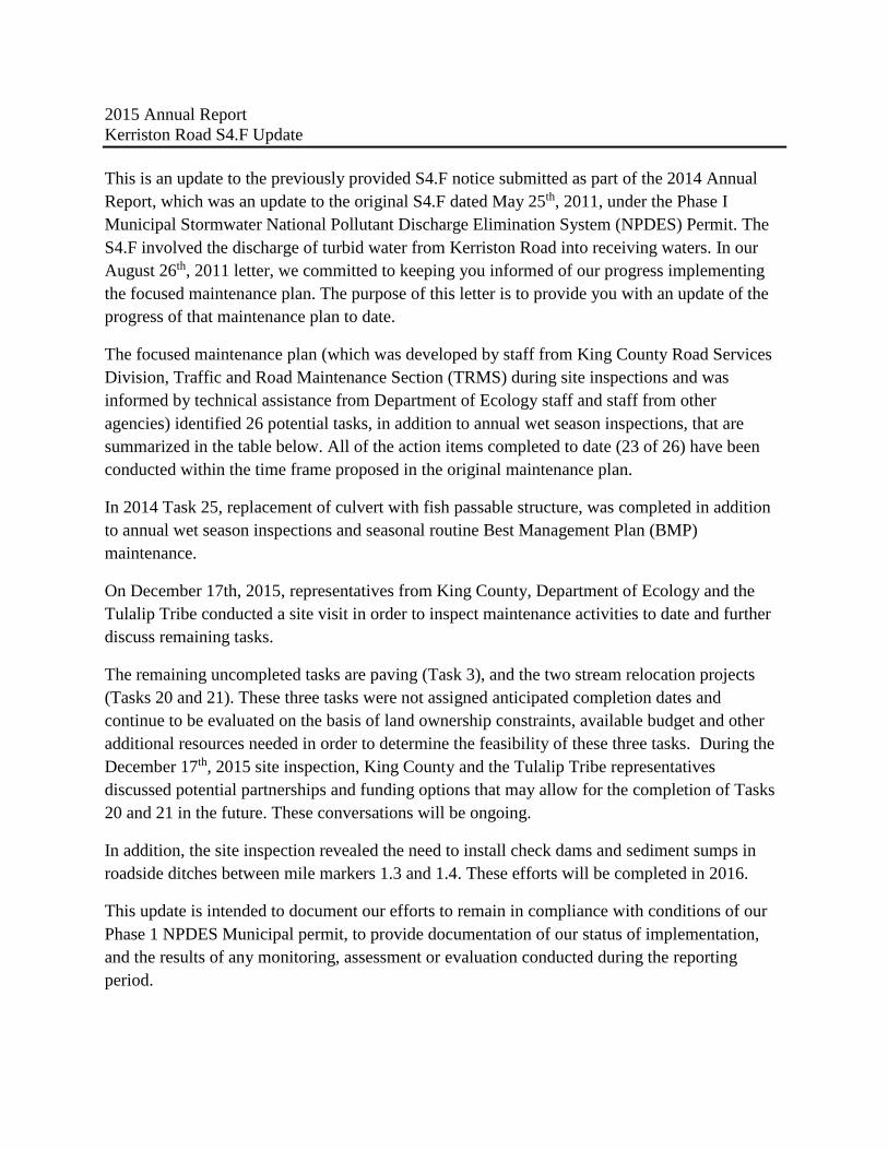
2015 Annual Report
Kerriston Road S4.F Update
This is an update to the previously provided S4.F notice submitted as part of the 2014 Annual
Report, which was an update to the original S4.F dated May 25th, 2011, under the Phase I
Municipal Stormwater National Pollutant Discharge Elimination System (NPDES) Permit. The
S4.F involved the discharge of turbid water from Kerriston Road into receiving waters. In our
August 26th, 2011 letter, we committed to keeping you informed of our progress implementing
the focused maintenance plan. The purpose of this letter is to provide you with an update of the
progress of that maintenance plan to date.
The focused maintenance plan (which was developed by staff from King County Road Services
Division, Traffic and Road Maintenance Section (TRMS) during site inspections and was
informed by technical assistance from Department of Ecology staff and staff from other
agencies) identified 26 potential tasks, in addition to annual wet season inspections, that are
summarized in the table below. All of the action items completed to date (23 of 26) have been
conducted within the time frame proposed in the original maintenance plan.
In 2014 Task 25, replacement of culvert with fish passable structure, was completed in addition
to annual wet season inspections and seasonal routine Best Management Plan (BMP)
maintenance.
On December 17th, 2015, representatives from King County, Department of Ecology and the
Tulalip Tribe conducted a site visit in order to inspect maintenance activities to date and further
discuss remaining tasks.
The remaining uncompleted tasks are paving (Task 3), and the two stream relocation projects
(Tasks 20 and 21). These three tasks were not assigned anticipated completion dates and
continue to be evaluated on the basis of land ownership constraints, available budget and other
additional resources needed in order to determine the feasibility of these three tasks. During the
December 17th, 2015 site inspection, King County and the Tulalip Tribe representatives
discussed potential partnerships and funding options that may allow for the completion of Tasks
20 and 21 in the future. These conversations will be ongoing.
In addition, the site inspection revealed the need to install check dams and sediment sumps in
roadside ditches between mile markers 1.3 and 1.4. These efforts will be completed in 2016.
This update is intended to document our efforts to remain in compliance with conditions of our
Phase 1 NPDES Municipal permit, to provide documentation of our status of implementation,
and the results of any monitoring, assessment or evaluation conducted during the reporting
period.
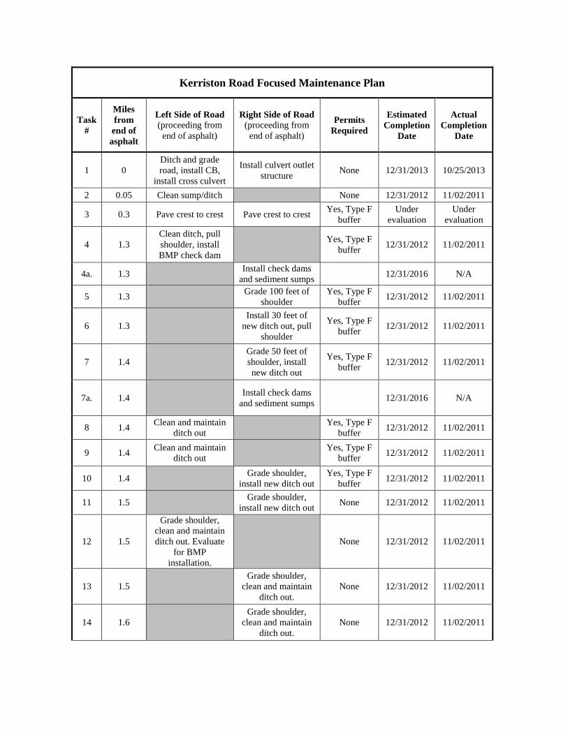
Kerriston Road Focused Maintenance Plan
Task
#
Miles
from
end of
asphalt
Left Side of Road
(proceeding from
end of asphalt)
Right Side of Road
(proceeding from
end of asphalt)
Permits
Required
Estimated
Completion
Date
Actual
Completion
Date
1 0
Ditch and grade
road, install CB,
install cross culvert
Install culvert outlet
structure None 12/31/2013 10/25/2013
2 0.05 Clean sump/ditch None 12/31/2012 11/02/2011
3 0.3 Pave crest to crest Pave crest to crest Yes, Type F
buffer
Under
evaluation
Under
evaluation
4 1.3
Clean ditch, pull
shoulder, install
BMP check dam
Yes, Type F
buffer 12/31/2012 11/02/2011
4a. 1.3 Install check dams
and sediment sumps 12/31/2016 N/A
5 1.3 Grade 100 feet of
shoulder
Yes, Type F
buffer 12/31/2012 11/02/2011
6 1.3
Install 30 feet of
new ditch out, pull
shoulder
Yes, Type F
buffer 12/31/2012 11/02/2011
7 1.4
Grade 50 feet of
shoulder, install
new ditch out
Yes, Type F
buffer 12/31/2012 11/02/2011
7a. 1.4 Install check dams
and sediment sumps 12/31/2016 N/A
8 1.4 Clean and maintain
ditch out
Yes, Type F
buffer 12/31/2012 11/02/2011
9 1.4 Clean and maintain
ditch out
Yes, Type F
buffer 12/31/2012 11/02/2011
10 1.4 Grade shoulder,
install new ditch out
Yes, Type F
buffer 12/31/2012 11/02/2011
11 1.5
Grade shoulder,
install new ditch out None 12/31/2012 11/02/2011
12 1.5
Grade shoulder,
clean and maintain
ditch out. Evaluate
for BMP
installation.
None 12/31/2012 11/02/2011
13 1.5
Grade shoulder,
clean and maintain
ditch out.
None 12/31/2012 11/02/2011
14 1.6
Grade shoulder,
clean and maintain
ditch out.
None 12/31/2012 11/02/2011

15 1.6
Grade shoulder,
clean and maintain
ditch out.
None 12/31/2012 11/02/2011
16 1.6
Grade shoulder,
clean and maintain
ditch out.
None 12/31/2012 11/02/2011
17 1.8 Grade shoulder None 12/31/2012 11/02/2011
18 2.8
Remove sediment
from roadside
pullout
Yes, Type F
buffer 12/31/2012 11/02/2011
19 2.8
Clean culvert inlet
and ditch, install
sediment control
BMP
Yes, Type F
buffer 12/31/2012 11/02/2011
20 3.5
Evaluate installation
of cross tile to
relocate stream out
of roadside ditch
Yes, Type N
water
Under
evaluation
Under
evaluation
21 3.6-3.7
Evaluate relocation
of stream away from
road
Yes, Type F
water
Under
evaluation
Under
evaluation
22 3.7
Clean catch basin
and cross tile, install
rock in road bed
Yes, Type F
buffer 12/31/2012 11/02/2011
23 3.7 Maintain ditch out None 12/31/2012 11/02/2011
24 3.7
Clean culvert inlet
and ditch, install
sediment control
BMP
None 12/31/2012 11/02/2011
25 3.8
Replace culvert with
fish passable
structure.
Replace culvert
with fish passable
structure.
Yes, Type F
water and
buffer
12/31/2016 09/12/2014
26 3.9
Grade 50 feet of
shoulder to remove
berm
Yes, Type F
buffer 12/31/2012 11/02/2011
Additional Tasks Completed Date Completed
Installation of approximately nine new ditch outs 11/02/2011
Cleaning of approximately 24 cross culverts 11/02/2011
Cleaning of one driveway culvert 11/02/2011
Wet season inspection 11/23/2011
Wet season inspection 11/19/2012
Wet season inspection/ BMP maintenance 11/12/2013
Wet season inspection/ BMP maintenance 11/25/2014
Wet season inspection 12/17/2017

Attachment 2015 Annual Report Question #72:
Attach a description of any stormwater monitoring or stormwater-related studies
per S8.A.
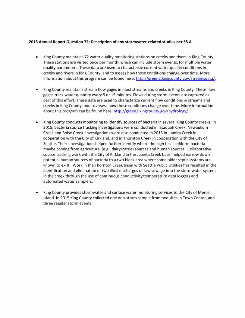
2015 Annual Report Question 72: Description of any stormwater-related studies per S8.A
King County maintains 72 water quality monitoring stations on creeks and rivers in King County. These stations are visited once per month, which can include storm events, for multiple water quality parameters. These data are used to characterize current water quality conditions in creeks and rivers in King County, and to assess how those conditions change over time. More information about this program can be found here: http://green2.kingcounty.gov/streamsdata/.
King County maintains stream flow gages in most streams and creeks in King County. These flow gages track water quantity every 5 or 15 minutes. Flows during storm events are captured as part of this effort. These data are used to characterize current flow conditions in streams and creeks in King County, and to assess how those conditions change over time. More information about this program can be found here: http://green2.kingcounty.gov/hydrology/.
King County conducts monitoring to identify sources of bacteria in several King County creeks. In 2015, bacteria source tracking investigations were conducted in Issaquah Creek, Newaukum Creek and Boise Creek. Investigations were also conducted in 2015 in Juanita Creek in cooperation with the City of Kirkland, and in Thornton Creek in cooperation with the City of Seattle. These investigations helped further identify where the high fecal coliform bacteria maybe coming from agricultural (e.g., dairy/cattle) sources and human sources. Collaborative source tracking work with the City of Kirkland in the Juanita Creek basin helped narrow down potential human sources of bacteria to a two block area where some older septic systems are known to exist. Work in the Thornton Creek basin with Seattle Public Utilities has resulted in the identification and elimination of two illicit discharges of raw sewage into the stormwater system in the creek through the use of continuous conductivity/temperature data loggers and automated water samplers.
King County provides stormwater and surface water monitoring services to the City of Mercer Island. In 2015 King County collected one non-storm sample from two sites in Town Center, and three regular storm events.