attachment 3 environmental analysis and checklist · 3.3.1 environmental setting ... san diego mesa...
TRANSCRIPT
Attachment 3
Environmental Analysis and Checklist

This page intentionally left blank.

ATTACHMENT 3: ENVIRONMENTAL ANALYSIS AND CHECKLIST
Contents of this Attachment California Environmental Quality Act Requirements Project Description
• Environmental Setting • Existing Local, Specific, and Regional Plans and Habitat Conservation Plans • Statement of Project Objectives
Regulatory Authorities • Implementing Agencies • Regulating Agencies
Public Participation and Consultation • Consultation with other Agencies • Public Participation • Scientific Peer Review
Implementation Plan Environmental Checklist and Explanations Cumulative Analysis Alternatives Analysis and Selection of Preferred Alternative Economic Analysis 3.1 Purpose and Objectives of the Basin Plan Amendment Project Los Peñasquitos Lagoon (Lagoon) is designated by US Environmental Protection Agency (US EPA), under Section 303(d) of the federal Clean Water Act, as impaired by sediment. Sediment in the lagoon compromises designated beneficial uses, including contact water recreation; non-contact water recreation; biological habitats of special significance; estuarine habitat; wildlife habitat; rare, threatened or endangered species; marine habitat; migration of aquatic organisms; fish spawning, reproduction and/or early development; and shellfish harvesting. The Project under consideration is the adoption of an amendment to the Water Quality Control Plan for the San Diego Basin (Basin Plan) incorporating a total maximum daily load (TMDL) for sediment in Lagoon. The purpose of the Basin Plan amendment project is to attain the water quality standard for sediment that will protect all uses. This will require dischargers of sediment to meet numeric sediment reduction targets, as stated in the Sediment TMDL for Los Peñasquitos Lagoon Draft Staff Report (Draft Staff Report). 3.2 California Environmental Quality Act Requirements The basic purposes of the California Environmental Quality Act (CEQA) are to: 1) inform decision makers and the public about potential significant environmental effects of a proposed project and give them opportunities to comment to the lead agency, 2) identify ways that environmental damage may be mitigated, 3) prevent significant,
3-4
avoidable damage to the environment by requiring changes in projects, through the use of implementation alternatives or mitigation measures when feasible, and 4) disclose to the public why an agency approved a project if significant effects may occur.1 The California Regional Water Quality Control Board, San Diego Region (San Diego Water Board) must comply with the CEQA when amending the Basin Plan as proposed in this project. Under CEQA, the San Diego Water Board is the Lead Agency for evaluating potential environmental impacts of the proposed project. Adoption of a Basin Plan amendment is an activity subject to CEQA requirements because Basin Plan amendments constitute rules or regulations requiring the installation of pollution control equipment, establishing a performance standard, or establishing a treatment requirement.2 Sections 3.2.1 and 3.2.2 below describe in detail the statutory requirements and scope of this environmental analysis required by CEQA for adoption of Basin Plan amendments and water quality standards. This TMDL Basin Plan amendment (TMDL) contains numeric targets designed to meet the narrative water quality objective for sediment and restore the beneficial uses in the Lagoon. The TMDL also includes wasteload allocations for point sources and load allocations for nonpoint sources and natural background. The numeric targets, together with the allocations, may be considered a new performance standard.3 Because development of a performance standard does not constitute development of a new water quality objective, but rather implements existing objectives to protect beneficial uses, the San Diego Water Board is not required to consider the factors in Water Code section 13241 (a) through (f).
3.2.1 Exemption from Requirement to Prepare Standard CEQA Documents CEQA authorizes the Secretary for Natural Resources to certify State regulatory programs designed to meet the goals of CEQA as exempt from requirements to prepare an Environmental Impact Report (EIR), Negative Declaration, or Initial Study. The Water Boards’ Basin Plan amendment process is a certified regulatory program and is therefore exempt from CEQA’s requirements to prepare such documents.4 As such, the “substitute environmental documents” that support the San Diego Water Board’s proposed basin planning action contain the required environmental documentation under CEQA.5 The substitute environmental documents (SED) include the environmental checklist, the detailed Staff Report, peer review and public comments and responses to comments, this resolution, and the Basin Plan Amendment.
1 14 CCR section 15002(a) 2 14 CCR section 15187 (a) and Public Resources Code sections 21159-21159.4. 3 The term “performance standard” is defined in the rulemaking provisions of the Administrative Procedure Act [Government Code sections 11340-l 1359]. A “performance standard” is a regulation that describes an objective with the criteria stated for achieving the objective [Government Code section 11342(d)]. 4 14 CCR section 15251(g) and Public Resources Code section 21080.5. 5 23 CCR section 3777
3-5
3.2.2 Scope of Environmental Analysis The State Water Board’s CEQA implementation regulations6 describe the substitute environmental documents (SED) required for Basin Plan amendment actions. For this project, those documents include the Draft Staff Report, the draft Basin Plan amendment, and the environmental analyses contained in this Appendix. Specifically, these analyses include:7
1. A brief description of the proposed project, including a description of the environmental setting. In this case, the proposed project is the Basin Plan amendment adopting the Sediment TMDL for Los Peñasquitos Lagoon. This amendment is described in Section 3.3 of this attachment.
2. Identification of reasonably foreseeable environmental impacts of the proposed
project (Section 3.7).
3. Reasonable alternatives to the proposed project and mitigation measures to avoid or reduce any significant or potentially significant adverse environmental impacts (discussed in Section 3.7 and 3.9).
4. An analysis of reasonably foreseeable methods of compliance. The analysis
includes:
a. Identification of reasonably foreseeable methods of compliance with the project (Section 3.6);
b. A completed Environmental Checklist, with analysis of reasonably foreseeable significant adverse environmental impacts associated with those methods of compliance (Section 3.7);
c. An analysis of reasonably foreseeable alternative means of compliance, which would have less significant adverse environmental impacts (Section 3.9); and
d. An analysis of reasonably foreseeable mitigation measures that would minimize any unavoidable environmental impacts of the reasonably foreseeable methods of compliance (Section 3.7).
6 23 CCR section 3720 et seq. “Regulations for Implementation of the Environmental Quality Act of 1970.” 7 23 CCR section 3777

3-6
Additionally, the environmental analysis takes into account a reasonable range of:8
• Environmental factors • Economic factors • Technical factors • Population • Geographic areas • Specific sites
A “reasonable range” does not require an examination of every site, but a reasonably representative sample of the sites. The CEQA statute specifically states that the agency shall not conduct a “project level analysis.”9 Rather, a project level analysis must be performed by the responsible parties that are required to implement the TMDLs.10 Actual environmental impacts will necessarily depend upon the compliance strategy selected by the responsible parties identified in the Staff Report. If not properly implemented or mitigated at the project level, there could be adverse environmental impacts from implementing this TMDL. The SED identifies broad mitigation approaches that could be considered at the project level. Consistent with CEQA, the analysis in the SED does not engage in speculation or conjecture, but rather considers reasonably foreseeable environmental impacts of reasonably foreseeable methods of compliance, reasonably foreseeable mitigation measures, and reasonably foreseeable alternative means of compliance that would avoid, eliminate, or reduce the identified impacts. In preparing this environmental analysis, the San Diego Water Board has considered the pertinent requirements of state law,11 and intends this analysis to serve as a program level environmental review.12 3.3 Project Description As stated in Section 3.1 above, the project is adoption of an amendment to the San Diego Water Board’s Basin Plan, incorporating a sediment TMDL for the Lagoon and an implementation plan to achieve the TMDL. As the San Diego Water Board’s master planning document for water quality enhancement, restoration, and protection, the Basin Plan establishes the regulatory framework requiring actions that will reduce sediment inputs to the Lagoon to levels that will support the Lagoon’s beneficial uses.
3.3.1 Environmental Setting The Los Peñasquitos watershed is located in central San Diego County. Along with the Lagoon, the entire watershed is included in the Peñasquitos Hydrologic Unit (906), which also includes Mission Bay and several coastal tributaries. The Peñasquitos watershed includes portions of the following jurisdictions: City of San Diego, the City of 8 23 CCR section 3777(c); 14 CCR section 15187(d) 9 Public Resources Code section 21159(d) 10 Public Resources Code section 21159.2 11 Public Resources Code section 21159 and 14 CCR section 15187 12 14 CCR section 15152; 14 CCR section 15168

3-7
Poway, the City of Del Mar, and San Diego County. Approximately 54 percent of the Peñasquitos watershed has been developed (e.g., low density residential, industrial/transportation, and commercial institutional land uses), with 46 percent of that area classified as impervious according to San Diego Association of Governments 2000 land use coverage. The largest single land use type in the Peñasquitos watershed is open space. A map of the watershed can be found in Section 3 of the Staff Report. The watershed extends approximately 19 miles east, rising to an elevation of 2,600 feet above sea level. Los Peñasquitos, Carroll Canyon, and Carmel Creeks constitute the three sub-watersheds. Freshwater drains from the 93 square mile Los Peñasquitos watershed into the Lagoon. The Lagoon is a 0.6 square mile coastal salt marsh lagoon located in Torrey Pines State Park. The Lagoon is designated as a “State Preserve,” a label reserved for the rarest and most fragile state-owned lands. The Lagoon was formed when sea levels rose and flooded the young Los Peñasquitos River to form a deep embayment, which has filled with sediment over the millennia. Under present conditions, a permanent mouth opening to the ocean cannot be naturally maintained, except during exceptionally wet winters; therefore, the channel is often mechanically dredged to alleviate the danger of flooding and to improve the health of the Lagoon. Mouth closures are typically caused by coastal processes (deposition of sand and cobbles due to storms surges and wave action) and structures, such as the US Highway 101 abutments and railroad trestles. The Lagoon is listed on the 2010 Clean Water Act section 303(d) list as impaired for sedimentation/siltation.13 Los Peñasquitos Creek, a Lagoon tributary, is listed as impaired by enterococcus, fecal coliform, selenium, total dissolved solids, total nitrogen as N, and toxicity. The Lagoon and its contributing watershed support a variety of sensitive species (state or federal endangered, threatened, candidate, or species of special concern). Important resources in this area include saltmarsh, coastal sage scrub and southern maritime chaparral. Furthermore, the San Diego Multiple Species Conservation Program identifies multiple covered species within the Peñasquitos watershed including San Diego thorn-mint, Shaw’s agave, Del Mar manzanita, Encinitas baccharis, Orcutt’s brodiaea, wart-stemmed ceanothus, short-leaved dudleya, variegated dudleya, San Diego button-celery, San Diego barrel cactus, willowy monardella, San Diego goldenstar, Torrey pine, San Diego mesa mint, Riverside fairy shrimp, southwestern pond turtle, San Diego horned lizard, orange-throated whiptail, California brown pelican, white-faced ibis, Canada goose, northern harrier, Cooper’s hawk, golden eagle, western snowy plover, California least tern, burrowing owl, coastal cactus wren, California gnatcatcher, California rufous-crowned sparrow, Belding’s savannah sparrow, grasshopper sparrow, mountain lion and mule deer. (City of San Diego, 1997)
13 2010 Integrated Report – Clean Water Act Section 303(d) List and 305(b) Report. Available at: http://www.waterboards.ca.gov/water_issues/programs/tmdl/integrated2010.shtml
3-8
The climate in coastal San Diego County is generally mild. Annual temperatures average 65°F near the ocean. Average annual rainfall ranges from nine to eleven inches along the coast. There are three distinct seasons in the region: summer dry, winter dry, and winter wet weather. The winter wet weather season accounts for 85 to 90 percent of the annual rainfall.
3.3.2 Existing Local, Specific, and Regional Plans and Habitat Conservation Plans
Multiple Species Conservation Program The entire Peñasquitos watershed lies within the San Diego Multiple Species Conservation Program (MSCP) Plan. The City of San Diego, City of Del Mar, City of Poway, and County of San Diego implement their respective portions of the MSCP Plan through subarea plans, which describe specific implementing mechanisms for the MSCP. The majority of the Peñasquitos watershed lies within the City of San Diego MSCP Subarea Plan. The MSCP is a comprehensive, long-term habitat conservation plan that addresses the needs of multiple covered species and the preservation of natural vegetation communities in San Diego County. The MSCP addresses the potential impacts of urban growth, natural habitat loss, and species endangerment; and includes a plan to mitigate for the potential loss of the multiple covered species and their habitat due to the direct impacts of future development of both public and private lands within the MSCP area (City of San Diego, 1997). Los Peñasquitos Lagoon Enhancement Plan and Program The Los Peñasquitos Lagoon Foundation is dedicated to the restoration of the Lagoon, its associated uplands and the preservation of land for scenic, historic, educational, recreational, agricultural, scenic and open space opportunities. The Foundation regularly updates its Los Peñasquitos Lagoon Enhancement Plan and Program to reflect current Lagoon conditions and management needs and priorities. Current efforts the Foundation is undertaking include monitoring of the Lagoon and operation of a restoration basin.
Physical, Chemical, and Biological Monitoring The Pacific Estuarine Research Laboratory (PERL), based at San Diego State University, was contracted by the Foundation to monitor lagoon resources and use the data in its studies of regional wetland ecosystems. PERL monitored the physical and chemical characteristics of Lagoon channel water from 1987-2007 and sampled benthic invertebrates, fish, and saltmarsh vegetation from 1988-2004. These studies have led to the timely opening of the mouth and an increase in knowledge of the biology of southern California's estuaries. In July 2004, Lagoon monitoring was transferred to the Southwest Wetlands Interpretive Association and the Tijuana River National Estuarine Research Reserve.

3-9
Los Peñasquitos Creek Restoration Basin Located in the western reach of the Los Peñasquitos Canyon Preserve, the 2.8-acre restoration basin is designed to intercept sediment (4,400 cubic yard capacity) during moderate to large storm events, thereby helping protect the Lagoon from the impacts associated with sediment and siltation. In addition, the basin constructed by the Los Peñasquitos Lagoon Foundation was designed to minimize impacts to nearby sensitive habitats and the creek, view corridors for the public, and flooding risks to a nearby industrial park. All disturbed areas have been revegetated with native species of vegetation, replacing an area that was previously dominated by invasive plant species.
Los Peñasquitos Canyon Preserve Natural Resource Management Plan The Los Peñasquitos Canyon Preserve Natural Resource Management Plan (1998) was developed to provide guidance for the present and future development and maintenance of the Los Peñasquitos Canyon Preserve. The City of San Diego Development Services and Park and Recreation Departments are responsible for the administration of this plan. The County Planning Department is responsible for the administration of land use permits for County-owned land in the Los Peñasquitos Canyon Preserve and review of all public and County development proposals to determine conformity with County policies, Natural Resource Management Plan, and CEQA. Funding for enhancement, management, and maintenance for the Los Peñasquitos Canyon Preserve can come from a variety of sources. Some of the objectives of this plan include: • To establish management practices and means for implementation that will foster
cooperative County-City management strategies to preserve and protect cultural and biological resources while providing for future recreational use, maintenance, and land use in the Los Peñasquitos Canyon Preserve
• To enhance and restore native habitats in the Los Peñasquitos Canyon Preserve • To manage native wildlife species for their survival • To identify and maintain important wildlife corridors • To control erosion along trails and streambeds throughout the Los Peñasquitos
Canyon Preserve and further protect the watersheds • To facilitate public use which is compatible with the protection and preservation of
the natural and historical resources, such as picnicking, hiking, and other low-intensity recreational activities
• To ensure individual projects within the Los Peñasquitos Canyon Preserve meet federal, state, and local environmental standards and requirements
• To conduct education, outreach, and research programs which increase public awareness of the unique natural and cultural resources within the Preserve
• The Los Peñasquitos Canyon Preserve will eventually house two interpretative facilities, one run by the County focusing on cultural and historical resources and second run by the City focusing on natural history and biological resources with a
3-10
proposed location somewhere in the eastern portion of the Los Peñasquitos Canyon Preserve. (CVCC, 2006)
Peñasquitos Watershed Urban Runoff Management Plan The Peñasquitos Watershed Urban Runoff Management Plan 2008 (WURMP) was prepared by the City of Poway, as lead agency, in collaboration with the cities of San Diego, Del Mar, and the County of San Diego – all local agencies that have jurisdiction over the Peñasquitos Watershed. The WURMP meets the requirements of the National Pollutant Discharge Elimination System (NPDES) Municipal Storm Water Permit for San Diego Copermittees (San Diego Water Board Order No. 2007-01; “Order”). The Order requires development and implementation of WURMPs for each of nine watershed management areas within San Diego County, including the Peñasquitos watershed. The primary goal of the Order is to positively affect the water resources of the Peñasquitos Watershed while balancing economic, social, and environmental constraints. The Order identifies four primary objectives to strive towards this goal: (1) develop and expand methods to assess and improve water quality within the watershed; (2) integrate watershed principles into land use planning; (3) enhance public understanding of sources of water pollution; and (4) encourage the development of stakeholder participation. To help reach these goals and objectives, the WURMP identifies and prioritizes water quality related issues within the watershed that can be potentially attributed (wholly or partially) to discharges from the municipal storm drain systems and may be addressed through a cross-jurisdictional approach. Additionally, activities to abate sources of pollution and restore and protect beneficial uses are also identified. The WURMP was designed as an iterative process of watershed assessment, priority setting, monitoring, and implementation. At the conclusion of each yearly cycle, the process begins anew, allowing participants to respond to changing conditions or adjust strategies that have not performed as anticipated. This framework establishes mechanisms for the participants to evaluate priorities, improve coordination, assess program goals, and allocate finite resources in a cost-effective manner. Local General Plans and Municipal Codes The County of San Diego and Cities of Del Mar, Poway, and San Diego each have their own General Plans and Municipal Codes that establish policies of acceptable land uses and practices in their jurisdictions. General Plans and Municipal Codes form the framework for the growth and land development for each community.

3-11
3.4 Regulatory Authorities The following agencies have approval authority over the Basin Plan amendment, oversight on related regulatory and/or environmental matters, or responsibility for implementation of reasonably foreseeable means of compliance.
3.4.1 Federal Regulatory Agencies U. S. Environmental Protection Agency The US Environmental Protection Agency (US EPA) is responsible for implementing the Clean Water Act. Section 305(b) of the Clean Water Act mandates biennial assessments of the nation’s water resources. These water quality assessments are used, with any other available data and information solicited from the public, to identify and prioritize waters not attaining water quality standards. The resulting amalgamation of waters is referred to as the “303(d) List” or the “Impaired Waters List.” Clean Water Act section 303(d)(1)(C) and (d)(1)(D) require that the state establish TMDLs for each listed water. Those TMDLs, and the 303(d) List itself, must be submitted to USEPA every two years for approval under section 303(d)(2). The Clean Water Act mandates TMDLs or other actions to resolve listings for all pollutant-water body pairs on the 303(d) List. In California, US EPA delegates responsibility for developing TMDLs to the Water Boards. National Oceanic Atmospheric Administration/National Marine Fisheries Service (NOAA/NMFS) With the US Fish and Wildlife Service, NOAA/NMFS conducts Endangered Species Act Section 7 consultation for effects to migratory and endangered fish species; NOAA/NMFS also enforces the Magnuson-Stevens Fishery Conservation and Management Act, under which it regulates projects that may have a significant effect on such species within the Los Peñasquitos watershed.
US Fish and Wildlife Service The US Fish and Wildlife Service enforces the Endangered Species Act, the Migratory Bird Treaty Act, and the Bald and Golden Eagle Protection Act. With NOAA/NMFS, the agency conducts Endangered Species Act Section 7 consultation for possible effects to listed species with federal status.
US Army Corps of Engineers The US Army Corps of Engineers issues Clean Water Act section 404 permits for discharges to waters of the United States and dredging and fill projects in navigable waters.

3-12
3.4.2 California State Regulatory Agencies State Water Resources Control Board and the San Diego Regional Water Quality Control Board (Water Boards) The primary responsibility for water quality protection in California rests with the State Water Resources Control Board (State Water Board) and the nine Regional Water Quality Control Boards (Regional Water Boards). The State Water Board and Regional Water Boards share responsibility for regulating storm water discharges. The State Water Board issues statewide NPDES permits for the California Department of Transportation (Caltrans); for construction that disturbs more than one acre (Construction General Permit Order 2009-0009-DWQ; and for small municipal separate storm sewer systems (MS4s) under a General Permit for the Discharge of Storm Water from Small MS4s (WQ Order No. 2003-0005-DWQ). The Porter-Cologne Water Quality Protection Act of 1972 requires that water quality control plans in California, including basin plans and basin plan amendments, incorporate a plan of implementation. The Water Quality Control Plan for the San Diego Basin, in which the TMDL for sediment in the Lagoon will be incorporated, is the master planning document for water quality in San Diego. Basin Plan provisions, including TMDL implementation plans, are carried out and enforced by the San Diego Water Board through its various permitting authorities, orders, and prohibitions. The San Diego Water Board regulates storm water discharges from the NPDES Phase I MS4s that discharge to the Peñasquitos watershed. These permits require the municipalities to develop and implement comprehensive Storm Water Management Plans, which provide the framework for local government storm water programs. NPDES municipal storm water permits generally have five-year update cycles. Following adoption of the TMDL, the San Diego Water Board will incorporate the TMDL’s waste load allocations and associated milestone requirements into the permits, and require the co-permittees to amend their Storm Water Management Plans accordingly. While the California Department of Transportation is a Responsible Party to this TMDL and required to comply with the Water Quality Plan for the San Diego Basin when this TMDL is incorporated, the statewide NPDES permit regulating discharges from Caltrans will also be amended to include similar planning and waste load allocation requirements. The San Diego Water Board regulates other storm water discharges in the watershed, including surface discharges from agricultural and grazing activities, through waste discharge requirements and waivers of waste discharge requirements for individual dischargers. Waste discharge requirements issued to a number of large commercial property owners require implementation of best management practices to address storm water discharges.

3-13
In addition, Army Corps of Engineers cannot issue its Clean Water Act Section 404 permits until the San Diego Water Board has certified those projects under Section 401.
California Department of Fish and Game The California Department of Fish and Game issues permits for incidental takes of state listed species under sections 2081(b) and (c) of the California Endangered Species Act and provides section 2081 consultation for effects to listed species. If the Department determines that an activity may substantially adversely affect fish and wildlife resources, the applicant must prepare a Stream Alteration Agreement that includes reasonable conditions necessary to protect those resources. Compliance with CEQA is also required. California Coastal Commission The Coastal Commission, in partnership with coastal cities and counties, plans and regulates the use of land and water in the coastal zone. Development activities, which are broadly defined by the California Coastal Act to include (among others) construction of buildings, divisions of land, and activities that change the intensity of use of land or public access to coastal waters, generally require a coastal development permit from either the Coastal Commission or the local government. California State Lands Commission The California State Lands Commission (CSLC) manages nearly 4 million acres of “sovereign lands,” which includes the beds of (1) more than 120 rivers, streams, and sloughs; (2) nearly 40 non-tidal navigable lakes; (3) tidal navigable bays and lagoons; and (4) tidal and submerged lands adjacent to the entire coast and offshore islands of California from the mean high tide line to 3 nautical miles offshore. The CSLC manages this watery domain. The sovereign lands can only be used for public purposes consistent with provisions of the Public Trust such as fishing, water-dependent commerce and navigation, ecological preservation, and scientific study (CSLC, 2010).
3.4.3 Local Regulatory Agencies The County of San Diego, City of San Diego, City of Del Mar, and City of Poway have plans, policies, and ordinances that may be used to require mitigation of impacts caused by the kinds of controls proposed in Basin Plan amendment. The municipalities’ ordinances cover construction, grading, and development plans for land use regulations, community plans, and environmental statutes. City of San Diego The City of San Diego’s General Plan establishes the citywide policies for growth and development. The City of San Diego’s Community Plans provide refinement of the General Plan’s citywide policies, designates land uses, and offers additional location-based recommendations. The Los Peñasquitos Watershed contains portions of the following communities within the City of San Diego: Torrey Pines, Torrey Hills, Carmel
3-14
Valley, Los Peñasquitos Canyon Preserve, Mira Mesa, Del Mar Mesa, Pacific Highlands Ranch, Torrey Highlands, Rancho Peñasquitos, Carmel Mountain Ranch, Sabre Springs, Miramar Ranch North, Scripps Miramar Ranch, and Rancho Encantada. The City of San Diego implements and enforces the Elements of the General Plan (Land Use and Community Planning; Mobility; Economic Prosperity; Public Facilities, Services and Safety; Urban Design; Recreation; Historic Preservation; Conservation; Noise; and Housing) and Community Plans through its various departments including, but not limited to: Development Services, Environmental Services, Public Utilities, Park & Recreation, Public Works, and Transportation & Storm Water. City of Poway The City of Poway Public Works Department is responsible for the maintenance of public infrastructure and environmental programs including storm water and flood control. The City of Poway Department of Development Services administers and implements the City's planning, land use, building, and engineering functions. Other activities include providing customer service for all permit activities, developing land use ordinances and various specific plans, and reviewing development plans. These departments enforce the City of Poway’s Municipal Code, which includes such ordinances as Stormwater Management and Discharge Control, Wildland-Urban Interface Code, Building Code, Excavating and Grading, Drainage and Watercourse, Floodplain Management, Standard Urban Stormwater Mitigation Plan, and Zoning. City of Del Mar The City of Del Mar Planning and Community Development Department is responsible for a variety of services ranging from updating the City’s General Plan and Zoning standards, managing key programs and projects such as the Clean Water Program, to preparation of new standards. This department oversees building services, code enforcement, and new development and construction for compliance. The City of Del Mar enforces local ordinances including, but not limited to: Noise Regulations, Fire Code, Stormwater Management and Discharge Control, Building and Construction, and Zoning Ordinances through issuance of permits. Permits include, but are not limited to land conservation, excavation, and grading permits. County of San Diego Within the County of San Diego, the Land Use and Environmental Group coordinates the County’s efforts in land use, environmental protection and preservation, recreation, and infrastructure development and maintenance. The Land Use and Environmental Group consists of seven departments: Air Pollution Control District; Agriculture, Weights and Measures; Environmental Health; Farm and Home Advisor; Parks and Recreation; Planning and Land Use; and Public Works. These departments issue a variety of permits to enforce County Ordinances including, but not limited to: Biological Mitigation; Resource Protection; Zoning; Watershed Protection, Stormwater Management, and Discharge Control; Noise; Flood Damage Protection; Habitat Loss Permit; Grading, Clearing, and Watercourses Ordinances.
3-15
Air Pollution Control District The County of San Diego Air Pollution Control District evaluates and issues construction and operating permits to ensure proposed new or modified commercial and industrial equipment and operations comply with air pollution control laws. Planning and Land Use The County of San Diego Department of Planning and Land Use (DPLU) issues various permits including building and discretionary permits. The DPLU is home to the Green Building Program and Multiple Species Conservation Program. In general, DPLU helps create and maintain the general plan; maintain and improve the zoning ordinance; and advise the Board of Supervisors and San Diego County Planning Commission on land use projects. Public Works The County of San Diego Public Works Department issues a variety of permits including: construction, drainage easement encroachment, encroachment, excavation, grading, moving, planting, and traffic control permits. The Public Works Department is responsible for: County-maintained roads; traffic engineering; land development civil engineering review; design engineering and construction management; land surveying and map processing; cartographic services; watershed quality and flood protection; County Airports; solid waste planning and diversion; inactive landfills; wastewater systems management; and special districts, such as the Flood Control District.
3.5 Public Participation and Consultation
3.5.1 Consultation with other agencies The Notice of Filing noticing the availability of the substitute environmental documents for this project was posted on the San Diego Water Board website and in the San Diego Union Tribune on February 15, 2012. The Notice of Filing indicated that the formal public comment period began on Wednesday, February 15, 2012 and ended on Monday, April 2, 2012, for a total of 47 days. The February 15, 2012, Notice of Filing indicated the public hearing date of May 9, 2012. Following the cancelation of the May 9, 2012, public hearing, a notice of the cancelation and rescheduling of the public hearing was posted on the San Diego Water Board website and e-mailed to interested parties. The Notice of Filing serves as the notification to Responsible Agencies requesting consultation on the project and Trustee Agencies. As Trustee Agencies with resources affected by the project, the California Coastal Commission, California State Lands Commission, California Department of Fish and Game, US Fish and Wildlife Service, Office of Historic Preservation, and California Natural Resources Agency were provided the Notice of Filing by mail on Wednesday, February 15, 2012.

3-16
3.5.2 Public participation CEQA’s requirement for “Early Public Consultation” was met by holding a CEQA Scoping Meeting.14 Notice of the CEQA Scoping Meeting for this project was issued on January 6, 2011 for the February 15, 2011 CEQA Scoping Meeting. The notice was posted on the San Diego Water Board website on January 6, 2011, published in the North County Times on January 14, 2011, and published in the Union Tribune on January 13, 2011. The CEQA scoping meeting was held at the office of the San Diego Water Board on February 15, 2011 and was attended by city, county, and industry representatives. Comments received during the meeting have been incorporated into the substitute environmental documents. A stakeholder advisory group (SAG) was formed at the onset of this project. Participants included representatives of the Cities of Del Mar, Poway, and San Diego, County of San Diego, Caltrans, US EPA, California State Parks, Los Peñasquitos Lagoon Foundation, Coast Law Group, Tetra Tech, and AMEC. During 2008-2011, the SAG met frequently to discuss project development. The SAG provided insightful technical comments on early drafts of reports, suggested issues for technical peer review, raised important policy issues, and assisted with drafting the Implementation Plan. 3.6 Implementation Plan: Reasonably Foreseeable Methods of
Compliance with the Basin Plan amendment The Basin Plan amendment implementation plan would require actions to achieve the TMDL targets and allocations for sediment, and other actions to enhance sediment-related habitat attributes essential to water quality in the Lagoon. The proposed Basin Plan amendment would affect all segments of the Lagoon and its tributaries. The proposed Basin Plan amendment contains sediment allocations for dischargers. The amendment does not prescribe specific projects through which dischargers and discharge categories are to meet the sediment allocations. The San Diego Water Board would not directly undertake any actions that could physically change the environment. Adoption of the proposed Basin Plan amendment, however, would result in future actions by landowners, municipalities and other agencies to comply with the requirements of the Basin Plan amendment and these actions could result in physical changes to the environment. The environmental impacts of such physical changes are evaluated below to the extent that they are reasonably foreseeable. Additionally, the Basin Plan amendment may result in future actions by municipalities to revise or adopt local permits, enforce local ordinances and permits, or educate watershed residents and businesses. In accordance with CEQA, changes that are speculative in nature do not require environmental review. Until the parties that must comply with a permit or other requirements derived from the Basin Plan amendment propose specific projects, many physical changes cannot be anticipated. That said, it is reasonably foreseeable that the following environmental changes may result from reasonably foreseeable methods of compliance: (1) minor 14 14 CCR section 15083

3-17
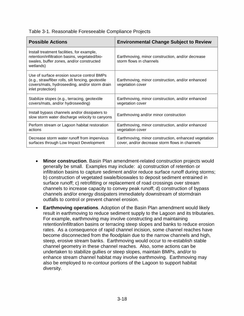
construction, (2) earthmoving, (3) vegetation enhancement, and (4) decrease storm flows in channels. Although these activities are reasonably foreseeable methods of compliance, the implementation plan does not specify the nature of these actions. Therefore, this analysis considers these actions in general programmatic terms. To illustrate the possible nature of these activities, some examples are described following the table.
3-18
Table 3-1. Reasonable Foreseeable Compliance Projects
Possible Actions Environmental Change Subject to Review
Install treatment facilities, for example, retention/infiltration basins, vegetated/bio-swales, buffer zones, and/or constructed wetlands)
Earthmoving, minor construction, and/or decrease storm flows in channels
Use of surface erosion source control BMPs (e.g., straw/fiber rolls, silt fencing, geotextile covers/mats, hydroseeding, and/or storm drain inlet protection)
Earthmoving, minor construction, and/or enhanced vegetation cover
Stabilize slopes (e.g., terracing, geotextile covers/mats, and/or hydroseeding)
Earthmoving, minor construction, and/or enhanced vegetation cover
Install bypass channels and/or dissipaters to slow storm water discharge velocity to canyons Earthmoving and/or minor construction
Perform stream or Lagoon habitat restoration actions
Earthmoving, minor construction, and/or enhanced vegetation cover
Decrease storm water runoff from impervious surfaces through Low Impact Development
Earthmoving, minor construction, enhanced vegetation cover, and/or decrease storm flows in channels
• Minor construction. Basin Plan amendment-related construction projects would generally be small. Examples may include: a) construction of retention or infiltration basins to capture sediment and/or reduce surface runoff during storms; b) construction of vegetated swale/bioswales to deposit sediment entrained in surface runoff; c) retrofitting or replacement of road crossings over stream channels to increase capacity to convey peak runoff; d) construction of bypass channels and/or energy dissipaters immediately downstream of stormdrain outfalls to control or prevent channel erosion.
• Earthmoving operations. Adoption of the Basin Plan amendment would likely result in earthmoving to reduce sediment supply to the Lagoon and its tributaries. For example, earthmoving may involve constructing and maintaining retention/infiltration basins or terracing steep slopes and banks to reduce erosion rates. As a consequence of rapid channel incision, some channel reaches have become disconnected from the floodplain due to the narrow channels and high, steep, erosive stream banks. Earthmoving would occur to re-establish stable channel geometry in these channel reaches. Also, some actions can be undertaken to stabilize gullies or steep slopes, maintain BMPs, and/or to enhance stream channel habitat may involve earthmoving. Earthmoving may also be employed to re-contour portions of the Lagoon to support habitat diversity.

3-19
• Decrease Flows in Channels. Adoption of the Basin Plan amendment would foreseeably result in a decrease of wet weather flows in channels due to a reduction in peak discharge and a decrease in runoff volume from impermeable areas. A decrease in wet weather flows reduces erosion and the transport of sediment and pollutants. In addition, as the volume of dry weather flows decrease, nuisance flows are prevented from entering channels, resulting in a reduction of the channel’s base flow. Resultant potential decreases in flow may contribute to a decrease in the amount of riparian vegetation on gravel bars, flood plains, and lower channel banks in some stream reaches as well as in the amount of riparian vegetation in the Lagoon.
These examples are not intended to be exhaustive or exclusive. Other conceivable actions that could be taken as a result of the Basin Plan amendment require speculation, and therefore, cannot be evaluated. For example, although the implementation plan recognizes coordinated planning efforts among local, state, and federal government agencies to enhance water quality within the Peñasquitos watershed, actual outcomes and specific actions resulting from the proposed partnership are too speculative to determine at this time. Also, as discussed above, even in cases where some physical changes are foreseeable, the exact nature of these changes is speculative pending specific project proposals that will be ultimately put forth by those subject to requirements derived from the Basin Plan amendment. Under CEQA, the permitting agencies will be the Lead Agencies for such future projects.
3.7 Environmental Checklist This section contains the Lead Agency’s analysis of reasonably foreseeable environmental effects of the proposed Basin Plan amendment in each category in the environmental checklist.15 The proposed amendment does not define the specific actions that responsible parties would take to achieve water quality objectives. The San Diego Water Board has chosen not to specify methods of compliance with its regulations,16 and accordingly, actual environmental impacts will necessarily depend upon compliance strategies selected by the responsible parties. This analysis considers a reasonable range of compliance measures, as described in Section 3.6, above, and takes into account environmental and technical factors, population and geographic areas, and specific sites.
15 Appendix A to 23CCR sections 3720-3781 16 Water Code section 13360

3-20
Potentially
Significant Impact
Less Than Significant with Mitigation
Less Than Significant Impact
No Impact
I. AESTHETICS: Would the project:
a) Have a substantial adverse effect on a scenic vista
b) Substantially damage scenic resources, including, but not limited to, trees, rock outcroppings, and historic buildings within a state scenic highway
c) Substantially degrade the existing visual character or quality of the site and its surroundings?
d) Create a new source of substantial light or glare which would adversely affect day or nighttime views in the area?
Discussion: a) Potential implementation projects resulting from this Basin Plan amendment that include minor construction for sediment reduction installations and habitat restoration activities would not substantially affect the scenic resource or vista, nor the existing visual character or quality of any scenic site and its surroundings. Any physical changes to the aesthetic environment as a result of the Basin Plan amendment would be small in scale and short-term in nature until vegetation re-establishes in any disturbed areas. In addition, any potential implementation project will be required to comply with local ordinances, such as the County’s Scenic Area Regulations17 that regulate development in areas of high scenic value. Projects must also be consistent with general land use plans that exclude incompatible uses and structures to preserve and enhance the scenic resources in adjacent areas.18 Furthermore, one of the goals/objectives for urban habitat lands in the City of San Diego MSCP Subarea Plan is to afford visual enjoyment and psychological relief from urbanization, while supporting habitat for the maintenance of both common and rare species. Therefore, specific City of San Diego regulations that afford protection to MSCP areas also afford the protection of aesthetic and visual value. These regulations include the Resource Protection Ordinance; the Sensitive Coastal Resource Overlay Zone; the Environmentally Sensitive Lands Ordinance; and the Steep Hillside Guidelines. For these reasons, the Water Board finds that implementation of the TMDL will cause a less than significant impact, if any, on any scenic vistas in the area.
17 San Diego County Zoning Ordinance, Part 5 Special Area Regulations, section 5200 18 San Diego County General Plan, Chapter 5 Conservation and Open Space Element, Visual Resources

3-21
b) Potential implementation projects would not result in adverse aesthetic impacts to state scenic highways because there are no officially designated State or County scenic highways within the Los Peñasquitos watershed (Caltrans, 2011). c) Construction and installation of structural BMPs may create an aesthetically offensive view during construction and installation, but this would be temporary until construction is completed and re-vegetated areas become established. Potential implementation projects will be subject to permit review and compliance with local ordinances, such as the County’s Scenic Area Regulations19 that regulate development in areas of high scenic value and general land use plans that exclude incompatible uses and structures to preserve and enhance the scenic resources in adjacent. Structural BMPs can and should be designed to provide aesthetically pleasing wildlife habitat, recreational areas, and green spaces in addition to improving storm water quality. Appropriate architectural and landscape design practices, including screening, should be implemented to mitigate any adverse aesthetic effects or be constructed underground. Furthermore, one of the goals/objectives for urban habitat lands in the City of San Diego MSCP Subarea Plan is to afford visual enjoyment and psychological relief from urbanization, while supporting habitat for the maintenance of both common and rare species. Therefore, City of San Diego regulations, which afford protection to MSCP areas, also afford protection of aesthetic and visual value in that area. These regulations include the Resource Protection Ordinance; the Sensitive Coastal Resource Overlay Zone; the Environmentally Sensitive Lands Ordinance; and the Steep Hillside Guidelines. For these reasons, the Water Board finds that implementation of the TMDL will cause a less than significant impact on the existing visual character or quality of the site and its surroundings. d) Actions and projects that implement the Basin Plan amendment would not foreseeably include new lighting or installation of large structures that could generate reflected sunlight or glare. Adoption of the Basin Plan amendment would not result in adverse light and glare impacts.
19 Ibid.

3-22
Potentially
Significant Impact
Less Than Significant with Mitigation
Less Than Significant Impact
No Impact
II. AGRICULTURE AND FOREST RESOURCES: In determining whether impacts to agricultural resources are significant environmental effects, lead agencies may refer to the California Agricultural Land Evaluation and Site Assessment Model (1997) prepared by the California Dept. of Conservation as an optional model to use in assessing impacts on agriculture and farmland. In determining whether impacts to forest resources, including timberland, are significant environmental effects, lead agencies may refer to information compiled by the California Department of Forestry and Fire Protection regarding the state’s inventory of forest land, including the Forest and Range Assessment Project and the Forest Legacy Assessment Project; and the forest carbon measurement methodology provided in Forest Protocols adopted by the California Air Resources Board. Would the project:
a) Convert Prime Farmland, Unique Farmland, or Farmland of Statewide Importance (Farmland), as shown on the maps prepared pursuant to the Farmland Mapping and Monitoring Program of the California Resources Agency, to non-agricultural use?
b) Conflict with existing zoning for agricultural use, or a Williamson Act contract?
c) Conflict with existing zoning for, or cause rezoning of, forest land (as defined in Public Resources Code section 12220(g)), timberland (as defined by Public Resources Code section 4526), or timberland zoned Timberland Production (as defined by Government Code section 51104(g))?
d) Result in the loss of forest land or conversion of forest land to non-forest use?
e) Involve other changes in the existing environment which, due to their location or nature, could result in conversion of Farmland, to non-agricultural use or conversion of forest land to non-forest use?
Discussion: a) According to the California Department of Conservation’s (DOC) Farmland Mapping and Monitoring Program, the Los Peñasquitos watershed has a small amount of unique farmland acreage in the Cities of San Diego and Poway and the County of San Diego (DOC, 2010). DOC (2010) indicates that there is no prime farmland or farmland of statewide importance in the watershed. Potential BMP installations to reduce sediment discharge or storm flow and potential stream channel restoration activities will not cause a change in unique farmland land use. Therefore, adoption of the Basin Plan amendment will not result in conversion of prime farmland, unique farmland, or farmland of statewide importance to non-agricultural use and will not cause an impact. b) According to the DOC’s San Diego County Williamson Act Lands 2008 Map, there are no Williamson Act lands designated in the Los Peñasquitos watershed (DOC, 2009). Neither the City of San Diego nor the County has any exclusively zoned

3-23
agricultural zoning in the Los Peñasquitos watershed.20 The City of Poway also does not have specific zoning for agriculture; however, agricultural lands are included in the Open Space-Resource Management zones.21 BMP installations to reduce sediment discharges to protect downstream resources would not displace agricultural operations themselves. Additionally, potential implementation projects that include sediment reduction installations and habitat restoration activities would be relatively small in scale, be located in existing developed areas or on public lands along water courses, and would not conflict with existing agricultural zoning. Impacts on existing agricultural zones would be less than significant. c) Potential implementation projects resulting from this Basin Plan amendment will not conflict with existing zoning for, or cause rezoning of, forest land, timberland, or timberland zoned Timberland Production because forest land or timberland do not exist in the Los Peñasquitos watershed (Shih, 2002).22 Therefore, no impacts will occur. d) Potential implementation projects will not result in the loss of forest land or conversion of forest land to non-forest use because forest land does not exist in the Los Peñasquitos watershed.23 Therefore, no impacts will occur. e) Adoption of the Basin Plan amendment could increase the level of landowner participation in cooperative efforts to minimize soil disturbance in sensitive areas (on steep slopes and adjacent to stream channels), which could result in localized, minor reductions in the amount of land cultivated, particularly adjacent to stream channels. However, because less than 1 percent of the Los Peñasquitos watershed is used for unique farmland (DOC, 2010), any buffer or setback areas, which would be fallow, would comprise a small amount of land area. Therefore, less than significant impacts would result.
20 City of San Diego General Plan, Land Use and Community Planning Element, Figure LU-2; County of San Diego County General Plan Land Use Map. 21 Poway General Plan, Community Development Element. 22 City of San Diego General Plan, Land Use and Community Planning Element, Figure LU-2; Poway General Plan, Community Development Element; and County of San Diego County General Plan, Chapter 3 Land Use Element, Figure LU-1. 23 City of San Diego General Plan, Land Use and Community Planning Element, Figure LU-2; County of San Diego County General Plan Land Use Map.
3-24
Potentially
Significant Impact
Less Than Significant with Mitigation
Less Than Significant Impact
No Impact
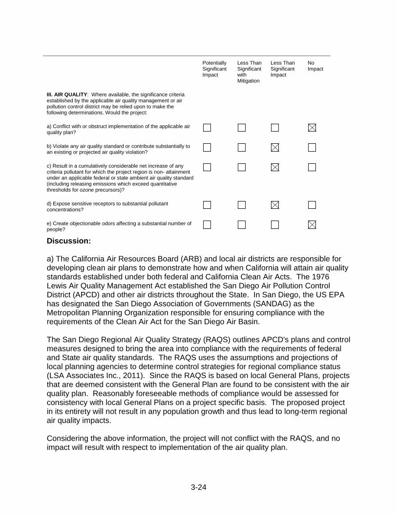
III. AIR QUALITY: Where available, the significance criteria established by the applicable air quality management or air pollution control district may be relied upon to make the following determinations. Would the project:
a) Conflict with or obstruct implementation of the applicable air quality plan?
b) Violate any air quality standard or contribute substantially to an existing or projected air quality violation?
c) Result in a cumulatively considerable net increase of any criteria pollutant for which the project region is non- attainment under an applicable federal or state ambient air quality standard (including releasing emissions which exceed quantitative thresholds for ozone precursors)?
d) Expose sensitive receptors to substantial pollutant concentrations?
e) Create objectionable odors affecting a substantial number of people?
Discussion: a) The California Air Resources Board (ARB) and local air districts are responsible for developing clean air plans to demonstrate how and when California will attain air quality standards established under both federal and California Clean Air Acts. The 1976 Lewis Air Quality Management Act established the San Diego Air Pollution Control District (APCD) and other air districts throughout the State. In San Diego, the US EPA has designated the San Diego Association of Governments (SANDAG) as the Metropolitan Planning Organization responsible for ensuring compliance with the requirements of the Clean Air Act for the San Diego Air Basin. The San Diego Regional Air Quality Strategy (RAQS) outlines APCD's plans and control measures designed to bring the area into compliance with the requirements of federal and State air quality standards. The RAQS uses the assumptions and projections of local planning agencies to determine control strategies for regional compliance status (LSA Associates Inc., 2011). Since the RAQS is based on local General Plans, projects that are deemed consistent with the General Plan are found to be consistent with the air quality plan. Reasonably foreseeable methods of compliance would be assessed for consistency with local General Plans on a project specific basis. The proposed project in its entirety will not result in any population growth and thus lead to long-term regional air quality impacts. Considering the above information, the project will not conflict with the RAQS, and no impact will result with respect to implementation of the air quality plan.

3-25
b) Both the state of California and the federal government have established health-based ambient air quality standards for seven air pollutants. These pollutants include ozone (O3), carbon monoxide (CO), nitrogen dioxide (NO2), sulfur dioxide (SO2), coarse particulate matter with a diameter of 10 microns or less (PM10), fine particulate matter less than 2.5 microns in diameter (PM2.5), and lead. In addition, the State has set standards for sulfates, hydrogen sulfide, vinyl chloride, and visibility-reducing particles. These standards are designed to protect the health and welfare of the populace with a reasonable margin of safety. Ambient air quality is in nonattainment with the federal 8-hour ozone standard, the state’s 8-hour and 1-hour ozone standards, and the state’s coarse and fine particulate matter standards (PM10 and PM2.5, respectively; San Diego APCD, 2009). In general, reasonably foreseeable air quality impacts from implementation of the Basin Plan amendment would be the result of construction activities and operation and maintenance. Construction impacts predominantly result from two sources: fugitive dust from surface disturbance activities; and exhaust emissions resulting from the use of construction equipment (including, but not-limited to: graders, dozers, back hoes, haul trucks, stationary electricity generators, and construction worker vehicles). One of the pollutants of concern during construction is particulate matter, since PM10 is emitted as windblown (fugitive) dust during surface disturbance and as exhaust of diesel-fired construction equipment (particularly as PM2.5). The potential for an incremental cancer risk resulting from diesel-fired construction equipment exists. Other emissions of concern include architectural coating products off-gassing (VOCs) and other sources of mobile source (on-road and off-road) combustion (NOx, SOx, CO, PM10, PM2.5, and VOCs) associated with the project (County of San Diego, 2007b). Operational and maintenance emissions are those that would occur after project construction activities have been completed and the project becomes operational. These emissions are a result of increased average daily vehicle trips as well as any proposed stationary sources associated with the reasonably foreseeable method of compliance. Depending on the characteristics of the individual project, operational activities have the potential to generate emissions of criteria pollutants. Operational impacts are predominantly the result of vehicular traffic associated with projects. Combustion emissions (NOx, SOx, CO, PM10, PM2.5, and VOCs) associated with mobile sources are generally the primary concern. This includes diesel particulate emissions from that portion of the mobile fleet that runs on diesel fuel (County of San Diego, 2007b). In September 2000, the ARB adopted the Diesel Risk Reduction Plan (Diesel RRP), which recommends many control measures to reduce the risks associated with DPM and to achieve goals of 75 percent diesel particulate matter reduction by 2010 and 85 percent by 2020. The Diesel RRP presents the ARB’s proposal for a comprehensive plan to significantly reduce diesel PM emissions by requiring all new diesel-fueled vehicles and engines to use state-of-the-art catalyzed diesel particulate filters and very
3-26
low-sulfur diesel fuel. In addition, all existing vehicles and engines should be evaluated, and wherever technically feasible and cost-effective, retrofitted with diesel particulate filters (ARB, 2000). Considering the above information, violation of any air quality standard or contribution to an existing or projected air quality violation will be less than significant. c) See discussion to section (b), above. Ambient air quality is in non-attainment with the federal 8-hour ozone standard, the state’s 8-hour and 1-hour ozone standards, and the State’s coarse and fine particulate matter standards (PM10 and PM2.5, respectively) (San Diego APCD, 2009). The project will result in a less than significant net increase of any criteria pollutant for which the San Diego Air Basin is non-attainment under an applicable federal or state ambient air quality standard. d) Sensitive receptors may exist in areas where construction and operational emissions will occur and subject sensitive receptors to diesel-fired particulates and carbon monoxide. In San Diego County, APCD Rule 1210 implements the public notification and risk reduction requirements of state law, which requires facilities with high potential health risk levels to reduce health risks below significant risk levels. In addition, APCD Rule 1200 establishes acceptable risk levels and emission control requirements for new and modified facilities that may emit additional toxic air contaminants (TACs). Under Rule 1200, permits to operate may not be issued when emissions of TACs result in an incremental cancer risk greater than 1 in 1 million without application of Toxics-Best Available Control Technology (T-BACT), an incremental cancer risk greater than 10 in 1 million with application of T-BACT, or a health hazard index (chronic and acute) greater than one. The human health risk analysis is based on the time, duration, and exposures expected (County of San Diego, 2007b). Emissions from the potential implementation projects resulting from this Basin Plan amendment would be short in duration, infrequent, and occur on a small scale, and therefore would not have a high health risk potential. Considering the above information, impacts to sensitive receptors will be less than significant. e) The Basin Plan amendment would not involve the construction of any permanent sources of odor and therefore would not create objectionable odors affecting a substantial number of people. No odor impacts would result from the project.

3-27
Potentially
Significant Impact
Less Than Significant with Mitigation
Less Than Significant Impact
No Impact
IV. BIOLOGICAL RESOURCES: Would the project:
a) Have a substantial adverse effect, either directly or through habitat modifications, on any species identified as a candidate, sensitive, or special status species in local or regional plans, policies, or regulations, or by the California Department of Fish and Game or US Fish and Wildlife Service?
b) Have a substantial adverse effect on any riparian habitat or other sensitive natural community identified in local or regional plans, policies, and regulations or by the California Department of Fish and Game or US Fish and Wildlife Service?
c) Have a substantial adverse effect on federally protected wetlands as defined by Section 404 of the Clean Water Act (including, but not limited to, marsh, vernal pool, coastal, etc.) through direct removal, filling, hydrological interruption, or other means?
d) Interfere substantially with the movement of any native resident or migratory fish or wildlife species or with established native resident or migratory wildlife corridors, or impede the use of native wildlife nursery sites?
e) Conflict with any local policies or ordinances protecting biological resources, such as a tree preservation policy or ordinance?
f) Conflict with the provisions of an adopted Habitat Conservation Plan, Natural Community Conservation Plan, or other approved local, regional, or state habitat conservation plan?
Discussion: a) The MSCP Plan is a comprehensive, long-term habitat conservation plan that addresses the needs of multiple covered species and the preservation of natural vegetation communities in San Diego County. The MSCP addresses the potential impacts of urban growth, natural habitat loss, and species endangerment; and includes a plan to mitigate for the potential loss of the multiple covered species and their habitat due to the direct impacts of future development of both public and private lands within the MSCP area. The MSCP identifies special status species; see the Environmental Setting section of this analysis (City of San Diego, 1997). The Basin Plan amendment was developed specifically to benefit, enhance, restore and protect biological resources, including fish, wildlife, rare and endangered species, and habitat. Nonetheless specific projects involving construction and earthmoving activities could potentially affect candidate, sensitive or special status species (collectively, special status species), either directly or through habitat modifications. Although minor construction and earthmoving operations would likely occur in already disturbed areas and might involve reconstruction, recontouring, or replacement of existing roads and structures, it is possible that these and other activities to reduce erosion and restore

3-28
stream or Lagoon habitat could occur in and impact areas where there are special status species and habitats. Some proposed projects that could affect sensitive species would be subject to review and approval by the San Diego Water Board. The San Diego Water Board, in the course of carrying out its statutory duties to protect water quality and beneficial uses (including preservation of rare and endangered species and wildlife habitat as set forth in the Basin Plan), will either not approve compliance projects with significant adverse impacts on special status species and habitats or require avoidance or mitigation measures to reduce impacts to less than significant levels. It is not reasonably foreseeable that the San Diego Water Board would approve earthmoving work that would disrupt or destroy habitat of a known special status species (since protection of rare and endangered species is one of the beneficial uses we are protecting in the Lagoon). Furthermore, it is the San Diego Water Board’s standard practice to work with the proponents of compliance projects to come up with actions that not only meet and further the proposed Basin Plan amendment’s requirements and goals, but also all other components of the Basin Plan, such as protection of rare and endangered species and habitat. For example, where avoidance of impacts is not possible, the San Diego Water Board requires mitigation measures for work it approves that may impact special status species, riparian habitats, or other sensitive natural communities. These include but are not limited to requiring pre-construction surveys; construction buffers and setbacks; restrictions on construction during sensitive periods of time; employment of on-site biologists to oversee work; and avoidance of construction in known sensitive habitat areas or relocation and restoration of sensitive habitats. In sum, through the course of the San Diego Water Board discharging its mandate to protect beneficial uses including rare and endangered species and wildlife habitat, impacts to special species and their habitats would be avoided or mitigated to less than significant levels. If, however, impacts to the special status species and their habitats occur outside the San Diego Water Board’s jurisdiction (e.g., in areas with no proximity or relation to waters of the state), then impacts must be addressed through other local, state, and federal regulatory programs. For example for projects that fill Clean Water Act Section 404 wetlands, the Army Corps of Engineers explicitly conditions its permits to require that impacts to federally listed species be less than significant. State and federal laws prohibit the take of special status species and their habitats except where incidental take permits have been issued. When issuing incidental take permits, state and federal agencies must ensure that the impacts of the take are minimized and mitigated to the maximum extent possible and ensure that the take will not appreciably reduce the likelihood of the survival and recovery of the species. Proposed projects would be subject to the County of San Diego’s Biological Mitigation Ordinance (BMO).24 The BMO is the implementing ordinance for the Multiple Species Conservation Program County Subarea Plan. Compliance with this ordinance allows
24 San Diego County Code, Title 8, Division 6, Chapter 5 Biological Mitigation Ordinance
3-29
the County to issue Incidental Take Permits for projects that impact sensitive habitats. The BMO establishes the criteria for avoiding impacts to Biological Resource Core Areas, to plant and animal populations within those areas, and the mitigation requirements for all projects requiring a discretionary permit. The BMO explains how mitigation for impacts is determined and establishes specific mitigation requirements for impacts to certain species. In addition, proposed projects would be subject to the County of San Diego’s Resource Protection Ordinance (RPO).25 The RPO requires that a Resource Protection Study must be completed prior to approval of any of the discretionary applications listed in section 86.603(a) of the San Diego County Code. If the Resource Protection Study identifies the presence of environmentally sensitive lands, one or more of the following actions may be required as a condition of approval for the discretionary permit: 1) Apply open space easements to portions of the project site that contain sensitive lands; 2) Rezone the entire project site through the application of a special area designator for sensitive lands; or 3) Other actions as determined by the decision-making body.26 Considering the above information, impacts, either directly or through habitat modifications, on any species identified as a candidate, sensitive, or special status species in local or regional plans, policies, or regulations, or by the California Department of Fish and Game or US Fish and Wildlife Service will be less than significant with mitigation. b) As indicated in section a) above, the Basin Plan amendment is designed to benefit biological resources, particularly riparian habitat and other sensitive natural communities. Nonetheless activities to improve riparian conditions, such as channel restoration and Lagoon restoration, could result in minor and short term disruption to riparian habitat. Projects proposed to comply with the Basin Plan amendment implementation plan involving grading or construction in the riparian corridor, are subject to review and approval by the San Diego Water Board. As described in section a) above, the San Diego Water Board, in the course of discharging its statutory duties to protect water quality and their beneficial uses will either not approve compliance projects with significant adverse impacts on riparian habitats and sensitive natural communities, or would require mitigation measures to reduce impacts to less than significant levels. Furthermore, it is the San Diego Water Board’s standard practice to work with California Department of Fish and Game, US Fish and Wildlife Service, and proponents of compliance projects to come up with actions that not only meet and further the project objective, but also have minimal impacts. Mitigation measures routinely required by the San Diego Water Board include (but are not limited to) requiring pre-construction surveys; construction buffers and setbacks; restrictions on construction during sensitive periods of time; employment of on-site biologists to oversee work; and avoidance of construction in known sensitive habitat areas or relocation and restoration of sensitive habitats, but only if avoidance is impossible.
25 San Diego County Code, Title 8, Division 6, Chapter 6 Resource Protection Ordinance 26 San Diego County Code, Title 8, Division 6, Chapter 6, Section 86.603(c)
3-30
However, if impacts to sensitive natural communities occur outside the San Diego Water Board’s jurisdiction, such as in upland communities, then impacts must be addressed through other local, state, and federal regulatory programs (as described in section a), above). Considering the above information, impacts to any riparian habitat or other sensitive natural community identified in local or regional plans, policies, and regulations or by the California Department of Fish and Game or US Fish and Wildlife Service would be less than significant with mitigation. c) Basin Plan amendment-related implementation actions may contribute to an increase in the acreage of land where habitat enhancement and/or erosion control projects are undertaken, a fraction of which could be within wetlands. The adverse impacts on wetlands would not be substantial. Under the Nationwide or Individual Permit programs administered by the US Army Corps of Engineers (per Section 404 of the Clean Water Act) there are general conditions that require that, for projects that may adversely affect wetlands, responsible parties must demonstrate that avoidance, minimization, and mitigation has occurred to the maximum extent practicable to ensure that adverse impacts to the aquatic environment are minimal. In addition, before the Army Corps can issue section a 404 permit, San Diego Water Board staff must certify the project (Section 401 certification) as compliant with state water quality standards, such as the Porter Cologne Water Quality Control Act, the California Wetland Conservation Policy, and the Basin Plan. If a water or wetland, although delineated under the 404(b)(1) guidelines is not considered a Water of the United States (and therefore subject to Section 404 permitting by the Army Corps), as a water of California it is still protected by state laws. Proposed discharges to non-federal waters of the state are subject to Waste Discharge Requirements pursuant to Water Code section 13260. This gives assurance that any potential impacts will be mitigated to a less than significant level. d) The Basin Plan amendment would not substantially interfere with the movement of any native resident or migratory fish or wildlife species, with established native resident or migratory wildlife corridors, or impede the use of native wildlife nursery sites. The main goal of the Basin Plan amendment is to improve and enhance the saltmarsh habitat in the Lagoon. Thus, compliance projects would entail improving habitat as wildlife corridors, not adversely affecting them. Therefore, no impacts will occur to the movement of any native resident or migratory fish or wildlife species, with established native resident or migratory wildlife corridors, or impacts to use of native wildlife nursery sites. e) The Basin Plan amendment itself does not conflict with any local policies or ordinances protecting biological resources. Therefore, no impacts will occur.
3-31
f) The Basin Plan amendment itself does not conflict with any adopted Habitat Conservation Plan, Natural Community Plan, or other approved local, regional or state habitat conservation plan, including the Los Peñasquitos Lagoon Enhancement Plan and Los Peñasquitos Canyon Preserve Natural Resource Management Plan. Therefore, no impacts will occur. Potentially
Significant Impact
Less Than Significant with Mitigation
Less Than Significant Impact
No Impact
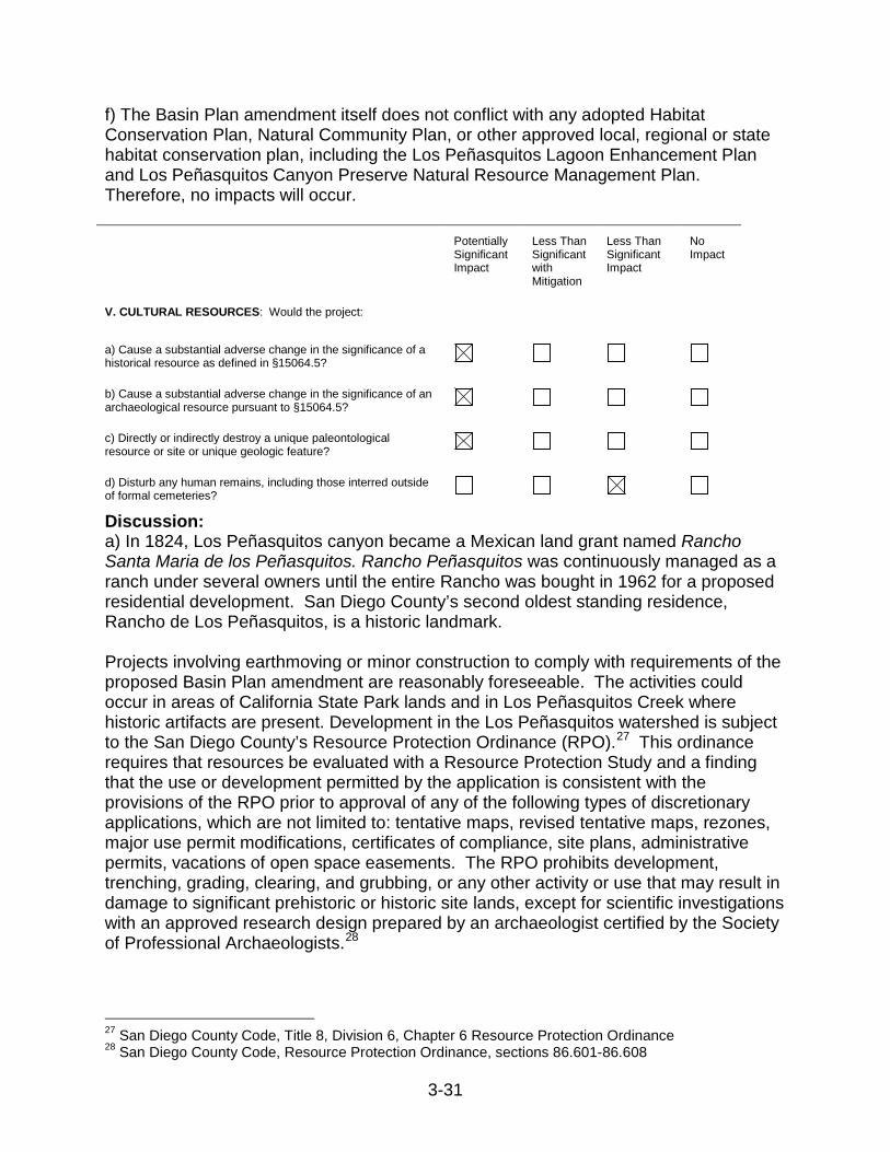
V. CULTURAL RESOURCES: Would the project:
a) Cause a substantial adverse change in the significance of a historical resource as defined in §15064.5?
b) Cause a substantial adverse change in the significance of an archaeological resource pursuant to §15064.5?
c) Directly or indirectly destroy a unique paleontological resource or site or unique geologic feature?
d) Disturb any human remains, including those interred outside of formal cemeteries?
Discussion: a) In 1824, Los Peñasquitos canyon became a Mexican land grant named Rancho Santa Maria de los Peñasquitos. Rancho Peñasquitos was continuously managed as a ranch under several owners until the entire Rancho was bought in 1962 for a proposed residential development. San Diego County’s second oldest standing residence, Rancho de Los Peñasquitos, is a historic landmark. Projects involving earthmoving or minor construction to comply with requirements of the proposed Basin Plan amendment are reasonably foreseeable. The activities could occur in areas of California State Park lands and in Los Peñasquitos Creek where historic artifacts are present. Development in the Los Peñasquitos watershed is subject to the San Diego County’s Resource Protection Ordinance (RPO).27 This ordinance requires that resources be evaluated with a Resource Protection Study and a finding that the use or development permitted by the application is consistent with the provisions of the RPO prior to approval of any of the following types of discretionary applications, which are not limited to: tentative maps, revised tentative maps, rezones, major use permit modifications, certificates of compliance, site plans, administrative permits, vacations of open space easements. The RPO prohibits development, trenching, grading, clearing, and grubbing, or any other activity or use that may result in damage to significant prehistoric or historic site lands, except for scientific investigations with an approved research design prepared by an archaeologist certified by the Society of Professional Archaeologists.28
27 San Diego County Code, Title 8, Division 6, Chapter 6 Resource Protection Ordinance 28 San Diego County Code, Resource Protection Ordinance, sections 86.601-86.608

3-32
Projects occurring within the City of San Diego are subject to the City of San Diego’s Historical Resources Regulations,29 which are intended to assure that development occurs in a manner that protects the overall quality of historical resources. It is further the intent of these regulations to protect the educational, cultural, economic, and general welfare of the public, while employing regulations that are consistent with sound historical preservation principles and the rights of private property owners.30 Furthermore, city and county General Plans contain policies that protect historic resources including the Conservation Element of the San Diego County General Plan, the Historical Preservation Element of the City of San Diego’s General Plan, the Historical Structures Chapter of the City of Poway’s Municipal Code, and the Historic Preservation Overlay Zone of the City of Del Mar’s Municipal Code. In addition, California Public Resources Code section 5024.5 requires that all state agencies consult with the Office of Historic Preservation when any proposed project may adversely affect any historical resources on state-owned property (including state parks), and section 5024 requires that all state agencies inventory, register, preserve, and maintain all historical resources within their jurisdiction. Considering the above information, the proposed projects that would occur as a result of the Basin Plan amendment would have a potentially significant impact on historical resources, but mitigation measures are available to reduce impacts to less than significant levels. However, implementation of these mitigation measures is within the jurisdiction of the local regulatory agencies listed in this document (Section 3.4.3). These agencies have the ability to implement these mitigation measures, can and should implement these mitigation measures, and are required under CEQA to implement mitigation measures unless mitigation measures are deemed infeasible through specific considerations.31 b) The Los Peñasquitos watershed is known to contain archeological sites, with artifacts found showing indigenous people living there for over 6,000 years. In addition, considerable archeological interest has been centered on the Lagoon because of the proximity of many Indian middens and campsites. Because these sites were occupied by La Jolla Indians between four and five thousand years ago, they usually contain many shells of both lagoon and ocean mollusks, some animal bones, and primitive stone implements (Mudie et al., 1974). Projects involving earthmoving or construction to comply with requirements of the proposed Basin Plan amendment are reasonably foreseeable. Construction would generally be small in scale, and earthmoving would likely occur in areas already disturbed by recent human activity (i.e., existing roads, and housing and industrial developments)—not at or in areas containing archaeological resources as defined by section 15064.5 of the CEQA Guidelines. In the event that unique archaeological resources are found, the project would be subject to California Public Resources Code section 21083.2, which requires that if a project will cause damage to a unique 29 City of San Diego Municipal Code, Chapter 14, Article 3, Division 2 Historical Resources Regulations 30 City of San Diego General Plan, Historic Preservation Element 31 14 CCR section 15091(a)(3)

3-33
archaeological resource, the lead agency for the project level environmental review may require reasonable efforts to be made to permit any or all of these resources to be preserved in place or left in an undisturbed state. Examples of that treatment, in no order of preference, may include, but are not limited to, any of the following: 1) planning construction to avoid archaeological sites, 2) deeding archaeological sites into permanent conservation easements, 3) capping or covering archaeological sites with a layer of soil before building on the sites, and/or 4) planning parks, greenspace, or other open space to incorporate archaeological sites. Furthermore, city and county General Plans contain policies that protect archaeological resources including the Conservation Element of the San Diego County General Plan, the Historical Preservation Element of the City of San Diego’s General Plan, the Historical Structures Chapter of the City of Poway’s Municipal Code, and the Historic Preservation Overlay Zone of the City of Del Mar’s Municipal Code. Considering the above information, the proposed projects that would occur as a result of the Basin Plan amendment would have a potentially significant impact on archaeological resources, but mitigation measures are available to reduce impacts to less than significant levels. However, implementation of these mitigation measures is within the jurisdiction of the local regulatory agencies listed in this document (Section 3.4.3). These agencies have the ability to implement these mitigation measures, can and should implement these mitigation measures, and are required under CEQA to implement mitigation measures unless mitigation measures are deemed infeasible through specific considerations.32 c) Potential projects will involve earthmoving or construction to comply with requirements of the proposed Basin Plan amendment. These projects will occur near sea cliffs, on valley slopes, within the Lagoon, and/or in floodplains. Paleontological resources are typically found in the geologic deposits of sedimentary rock (e.g. sandstone, siltstone, mudstone, claystone, or shale) under surficial soil deposits within these types of areas. The Torrey Sandstone, Santiago Peak Volcanics Metasedimentary, and Lusardi Formation geologic units occur within the Peñasquitos watershed. The Torrey Sandstone and Lusardi Formation units have high resource sensitivities whereas the Santiago Peak Volcanics Metasedimentary unit has moderate resource sensitivity (City of San Diego, 2007). In general, formations with high resource potential are considered to have the highest potential to produce unique invertebrate fossil assemblages or unique vertebrate fossil remains and are, therefore, highly sensitive. However, any project that is implemented will have to comply with local regulations and standards including the County of San Diego Grading Ordinance and the Conservation Element of the San Diego County General Plan. Section 87.430 of the Grading Ordinance provides for the requirement of a paleontological monitor at the discretion of the County. In addition, the suspension of grading operation is required upon the discovery of fossils greater than twelve inches in any dimension. The ordinance also
32 14 CCR section 15091(a)(3)

3-34
requires notification of the County Official (e.g. Permit Compliance Coordinator). The ordinance gives the County Official the authority to determine the appropriate resource recovery operations, which the permittee shall carry out prior to the County Official’s authorization to resume normal grading operations. For projects occurring within the City of San Diego, resources are identified and protected through the environmental review process for discretionary projects. Through the City of San Diego’s environmental process and prior to issuance of a Notice to Proceed (NTP) for any construction permits, including but not limited to, the first Grading Permit, Demolition Plans/Permits and Building Plans/Permits, the environmental review manager environmental designee shall verify that the requirements for Paleontological Monitoring have been noted on the appropriate construction documents. Considering the above information, the proposed projects that would occur as a result of the Basin Plan amendment would have a potentially significant impact on paleontological resources, but mitigation measures are available to reduce impacts to less than significant levels. However, implementation of these mitigation measures is within the jurisdiction of the local regulatory agencies listed in this document (Section 3.4.3). These agencies have the ability to implement these mitigation measures, can and should implement these mitigation measures, and are required under CEQA to implement mitigation measures unless mitigation measures are deemed infeasible through specific considerations.33 d) Projects involving earthmoving or construction to comply with requirements of the proposed Basin Plan amendment are reasonably foreseeable. Construction would generally be small in scale, and earthmoving would likely occur in areas already disturbed by recent human activity (i.e., existing roads, and housing and industrial developments)—not at or in areas human remains, such as the El Camino Memorial Park located in Sorrento Valley. In the event that human remains are discovered during a project level activity, the project proponent would be subject to Health and Safety Code section 7050.5, which requires that there shall be no further excavation or disturbance of the site or any nearby area reasonably suspected to overlay adjacent remains until the County Coroner has examined the remains. If the Coroner determines the remains to be those of an American Indian, or has reason to believe that they are those of an American Indian, the Coroner contacts, by telephone within 24 hours, the Native American Heritage Commission. Considering the above information, the proposed projects that would occur as a result of the Basin Plan amendment would not adversely affect human remains, and impacts would be less than significant.
33 14 CCR section 15091(a)(3)
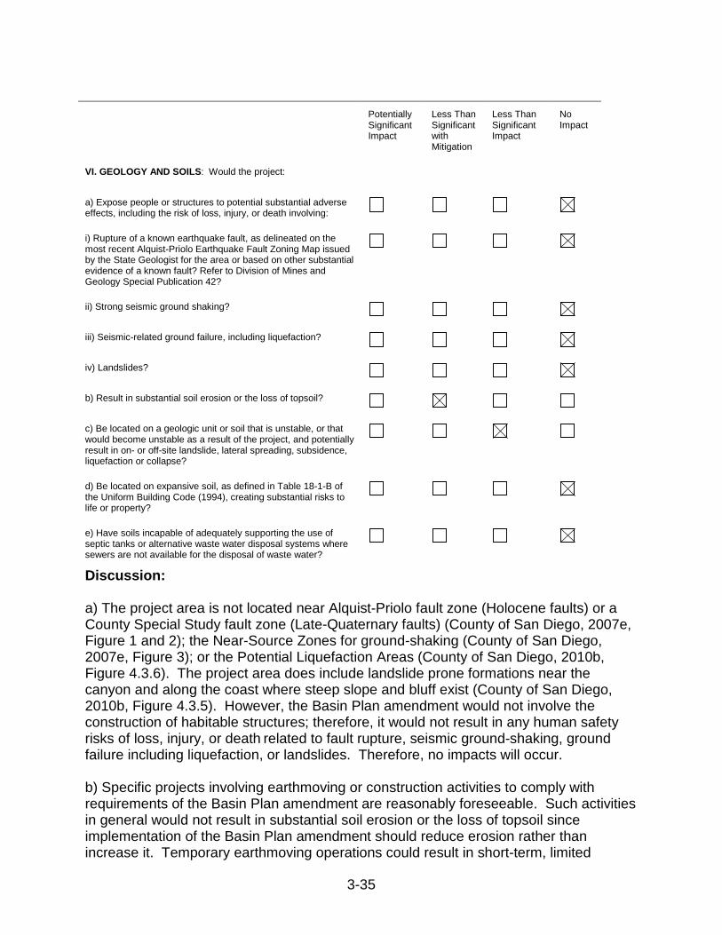
3-35
Potentially
Significant Impact
Less Than Significant with Mitigation
Less Than Significant Impact
No Impact
VI. GEOLOGY AND SOILS: Would the project:
a) Expose people or structures to potential substantial adverse effects, including the risk of loss, injury, or death involving:
i) Rupture of a known earthquake fault, as delineated on the most recent Alquist-Priolo Earthquake Fault Zoning Map issued by the State Geologist for the area or based on other substantial evidence of a known fault? Refer to Division of Mines and Geology Special Publication 42?
ii) Strong seismic ground shaking?
iii) Seismic-related ground failure, including liquefaction?
iv) Landslides?
b) Result in substantial soil erosion or the loss of topsoil?
c) Be located on a geologic unit or soil that is unstable, or that would become unstable as a result of the project, and potentially result in on- or off-site landslide, lateral spreading, subsidence, liquefaction or collapse?
d) Be located on expansive soil, as defined in Table 18-1-B of the Uniform Building Code (1994), creating substantial risks to life or property?
e) Have soils incapable of adequately supporting the use of septic tanks or alternative waste water disposal systems where sewers are not available for the disposal of waste water?
Discussion: a) The project area is not located near Alquist-Priolo fault zone (Holocene faults) or a County Special Study fault zone (Late-Quaternary faults) (County of San Diego, 2007e, Figure 1 and 2); the Near-Source Zones for ground-shaking (County of San Diego, 2007e, Figure 3); or the Potential Liquefaction Areas (County of San Diego, 2010b, Figure 4.3.6). The project area does include landslide prone formations near the canyon and along the coast where steep slope and bluff exist (County of San Diego, 2010b, Figure 4.3.5). However, the Basin Plan amendment would not involve the construction of habitable structures; therefore, it would not result in any human safety risks of loss, injury, or death related to fault rupture, seismic ground-shaking, ground failure including liquefaction, or landslides. Therefore, no impacts will occur. b) Specific projects involving earthmoving or construction activities to comply with requirements of the Basin Plan amendment are reasonably foreseeable. Such activities in general would not result in substantial soil erosion or the loss of topsoil since implementation of the Basin Plan amendment should reduce erosion rather than increase it. Temporary earthmoving operations could result in short-term, limited
3-36
erosion. Construction projects affecting an area of one acre or more would require a general construction National Pollutant Discharge Elimination System (NPDES) permit from the State Water Board, and implementation of a storm water pollution prevention plan to control sediment erosion and runoff. These projects will be subject to the review and inspection by the San Diego Water Board, and will require implementation of routine and standard erosion control best management practices and proper construction site management. Other grading projects would be subject to non-discretionary requirements of local ordinance and code to reduce potential soil erosion from grading. Therefore, the Basin Plan amendment would not result in substantial soil erosion, and any impacts would be less than significant with mitigation. c) Even though the project area includes landslide prone formations near the canyon and along the coast where steep slope and bluff exist (County of San Diego, 2010b), implementation of the Basin Plan amendment will not cause or result in further instability of these areas. On the contrary, implementation of the Basin Plan amendment will require actions to reduce sediment sources that may include landslide areas, eroding gullies, river banks and roads. Potential implementation projects would be designed to increase the stabilities of these unstable areas, both onsite and off-site, including minimization of any potential for landslides. Therefore, the Basin Plan amendment would not involve activities that would create or trigger landslide, lateral spreading, subsidence, liquefaction or collapse, and its impacts would be less than significant. d) The Basin Plan amendment would not involve construction of buildings (as defined in the Uniform Building Code) or any habitable structures. Minor grading and construction could occur in areas with expansive soils but this activity would not create a substantial risk to life or property. Therefore, the Basin Plan amendment would not result in impacts related to expansive soils. e) The Basin Plan amendment would not require wastewater disposal systems; therefore, affected soils need not be capable of supporting the use of septic tanks or alternative wastewater disposal systems. No impacts would result from the project with respect to septic tanks or alternative wastewater disposal systems.
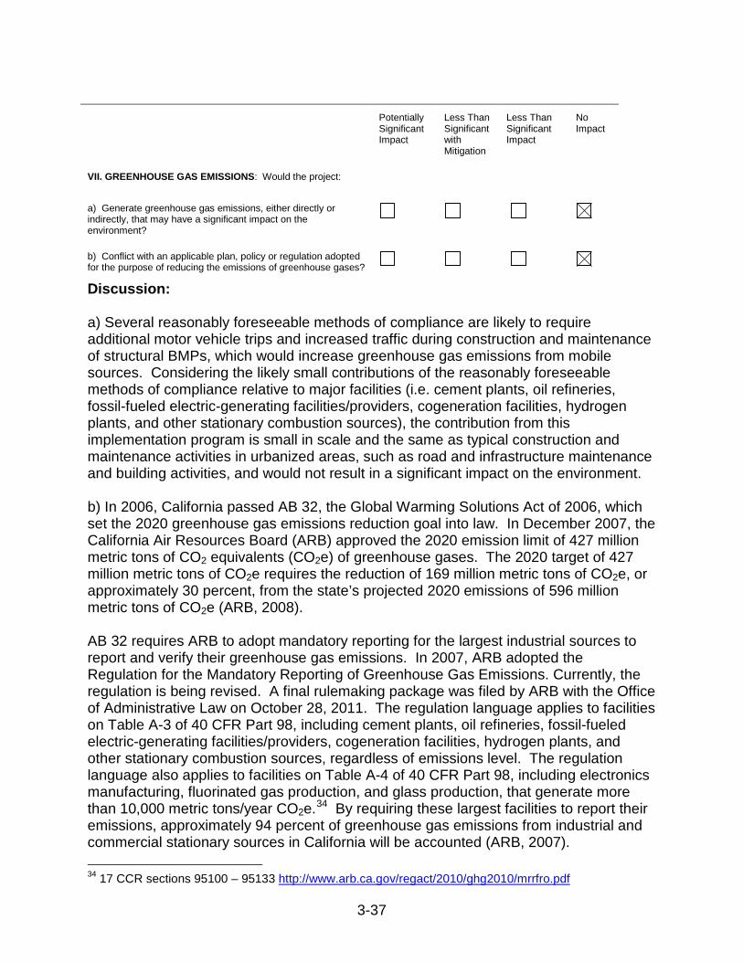
3-37
Potentially
Significant Impact
Less Than Significant with Mitigation
Less Than Significant Impact
No Impact
VII. GREENHOUSE GAS EMISSIONS: Would the project:
a) Generate greenhouse gas emissions, either directly or indirectly, that may have a significant impact on the environment?
b) Conflict with an applicable plan, policy or regulation adopted for the purpose of reducing the emissions of greenhouse gases?
Discussion: a) Several reasonably foreseeable methods of compliance are likely to require additional motor vehicle trips and increased traffic during construction and maintenance of structural BMPs, which would increase greenhouse gas emissions from mobile sources. Considering the likely small contributions of the reasonably foreseeable methods of compliance relative to major facilities (i.e. cement plants, oil refineries, fossil-fueled electric-generating facilities/providers, cogeneration facilities, hydrogen plants, and other stationary combustion sources), the contribution from this implementation program is small in scale and the same as typical construction and maintenance activities in urbanized areas, such as road and infrastructure maintenance and building activities, and would not result in a significant impact on the environment. b) In 2006, California passed AB 32, the Global Warming Solutions Act of 2006, which set the 2020 greenhouse gas emissions reduction goal into law. In December 2007, the California Air Resources Board (ARB) approved the 2020 emission limit of 427 million metric tons of CO2 equivalents (CO2e) of greenhouse gases. The 2020 target of 427 million metric tons of CO2e requires the reduction of 169 million metric tons of CO2e, or approximately 30 percent, from the state’s projected 2020 emissions of 596 million metric tons of CO2e (ARB, 2008). AB 32 requires ARB to adopt mandatory reporting for the largest industrial sources to report and verify their greenhouse gas emissions. In 2007, ARB adopted the Regulation for the Mandatory Reporting of Greenhouse Gas Emissions. Currently, the regulation is being revised. A final rulemaking package was filed by ARB with the Office of Administrative Law on October 28, 2011. The regulation language applies to facilities on Table A-3 of 40 CFR Part 98, including cement plants, oil refineries, fossil-fueled electric-generating facilities/providers, cogeneration facilities, hydrogen plants, and other stationary combustion sources, regardless of emissions level. The regulation language also applies to facilities on Table A-4 of 40 CFR Part 98, including electronics manufacturing, fluorinated gas production, and glass production, that generate more than 10,000 metric tons/year CO2e.34 By requiring these largest facilities to report their emissions, approximately 94 percent of greenhouse gas emissions from industrial and commercial stationary sources in California will be accounted (ARB, 2007). 34 17 CCR sections 95100 – 95133 http://www.arb.ca.gov/regact/2010/ghg2010/mrrfro.pdf
3-38
On December 11, 2008, ARB adopted its Climate Change Scoping Plan with re-approval occurring on August, 24, 2011. The Scoping Plan proposes a comprehensive set of actions designed to reduce overall carbon emissions in California. Key elements of California’s recommendations for reducing its greenhouse gas emissions to 1990 levels by 2020 include:
• Expanding and strengthening existing energy efficiency programs as well as building and appliance standards;
• Achieving a statewide renewables energy mix of 33 percent;
• Developing a California cap-and-trade program that links with other Western Climate Initiative partner programs to create a regional market system;
• Establishing targets for transportation-related greenhouse gas emissions for regions throughout California, and pursuing policies and incentives to achieve those targets;
• Adopting and implementing measures pursuant to existing state laws and policies, including California’s clean car standards, goods movement measures, and the Low Carbon Fuel Standard; and
• Creating targeted fees, including a public goods charge on water use, fees on high global warming potential gases, and a fee to fund the administrative costs of the state’s long term commitment to AB 32 implementation. (ARB, 2008)
Implementation of this TMDL will not conflict with implementation of the Climate Change Scoping Plan and no impact will occur.

3-39
Potentially
Significant Impact
Less Than Significant with Mitigation
Less Than Significant Impact
No Impact
VIII. HAZARDS AND HAZARDOUS MATERIALS: Would the project:
a) Create a significant hazard to the public or the environment through the routine transport, use, or disposal of hazardous materials?
b) Create a significant hazard to the public or the environment through reasonably foreseeable upset and accident conditions involving the release of hazardous materials into the environment?
c) Emit hazardous emissions or handle hazardous or acutely hazardous materials, substances, or waste within one-quarter mile of an existing or proposed school?
d) Be located on a site which is included on a list of hazardous materials sites compiled pursuant to Government Code Section 65962.5 and, as a result, would it create a significant hazard to the public or the environment?
e) For a project located within an airport land use plan or, where such a plan has not been adopted, within two miles of a public airport or public use airport, would the project result in a safety hazard for people residing or working in the project area?
f) For a project within the vicinity of a private airstrip, would the project result in a safety hazard for people residing or working in the project area?
g) Impair implementation of or physically interfere with an adopted emergency response plan or emergency evacuation plan?
h) Expose people or structures to a significant risk of loss, injury or death involving wildland fires, including where wildlands are adjacent to urbanized areas or where residences are intermixed with wildlands?
Discussion: a) Compliance with the Basin Plan amendment implementation plan does not involve the routine transport, use, or disposal of hazardous materials. Therefore, no impacts from the use, transport or disposal of hazardous materials would result. b) The Basin Plan amendment does not include actions that are likely to result in upset or accident conditions involving the release of hazardous materials. Potential implementation projects that include sediment reduction installations and habitat restoration activities would be relatively small in scale, be located in existing developed areas or on public lands along water courses, and would not contain, handle, or store any potential sources of chemicals or compounds that would present a significant risk of accidental explosion or release of hazardous substances. Therefore, no impacts will occur.

3-40
c) Basin Plan amendment actions such as minor construction to reduce erosion and habitat restoration projects would be located along the storm water conveyance system right of way and stream channels in areas used as open space, which are not likely to contain schools. In any case, the Basin Plan amendment and TMDL implementation actions would not emit hazardous materials, substances, or waste. Therefore, no impact from hazardous materials would occur within one-quarter mile of an existing or proposed school. d) It is unlikely that Basin Plan amendment actions would occur on sites that are included on lists of hazardous material sites compiled pursuant to Government Code Section 65962.5, such as leaky underground storage tank sites or sites where hazardous materials violations have occurred. The possibility that hazardous materials or substances will be encountered during project activities on or near these sites is speculative and need not be considered in this analysis. Therefore, there would be no impacts from hazardous materials sites. e) The Basin Plan amendment does not include actions that would result in a safety hazard to people residing or working in any potential project areas from a public airport. The Los Peñasquitos watershed is not within an airport land use plan, or within two miles of a public airport or public use airport; therefore, the Basin Plan amendment would not result in an air safety hazard for people residing or working in the project area. f) A large portion of the watershed lies within the overflight influence of the Marine Corps Air Station Miramar (MCAS Miramar), which is located in the Rose Canyon Creek watershed immediately to the south of Los Peñasquitos watershed (ALUC, 2010). MCAS Miramar Airport Land Use Compatibility Plan (MCAS Miramar ALUCP) indicates that a portion of the Lagoon and the lower part of Carroll Canyon are in Accident Potential Zone II (APZII) bordered by a narrow Transition Zone (TZ) around the perimeter (ALUC 2010). APZII and TZ are the third and final tiers of the safety-related zones identified by the US Marine Corps and have the lowest potential for occurrence of aircraft accidents of the safety zones, which is based on distance from the ends of the runways. MCAS Miramar ALUCP necessitates restrictions on land uses in these safety zones for infill development (construction of residential and nonresidential buildings where people will inhabit or congregate). Potential implementation projects that include minor construction for sediment reduction installations and habitat restoration activities are not identified as the type of development requiring restriction. However, the construction and maintenance activities associated with these types of projects would be expected to meet or be below the APZII Maximum Intensity Limit of 50 people per acre, as set by the MCAS Miramar ALUCP for the “Water, Rivers, Creeks, Canals, Wetlands, Bays, Lakes, and Reservoirs” land use. These types of implementation projects in these two safety zones have a low potential for ground hazard from flight-related accidents during the construction phase and periodic maintenance work and represent a less than significant impact. There are several private heliports in the vicinity of the Lagoon and preserve and Carroll Canyon Creek: San Diego Heliport, Qualcomm Building T Heliport, Henley Heliport, the
3-41
Plaza La Jolla Village Heliport, and Scripps Memorial Hospital La Jolla Heliport. The Federal Aviation Administration published an Advisory Circular for Heliport Design (AC) that provides guidance with respect to the design of the touchdown and liftoff pad for helicopters and requirements for obstruction-free approach/departure paths (FAA, 2004). The AC recommends helipad protection zones for public use facilities. These zones, equivalent to runway protection zones at airports, extend 280 feet from the edge of the Final Approach and Takeoff Area (FATO). A FATO is generally larger than the physical pad itself and its size usually depends on the size of the helicopters that will utilize the helipad. Potential implementation projects that include minor construction for sediment reduction installations and habitat restoration activities are not likely to be within the protection zone of any of the local helipads. There would be no impact from the presence of these local helipads. Considering the above information as a whole, potential implementation projects result in a less than significant impact to the safety for people residing or working in the project area. g) The following applicable emergency response plans or emergency evacuation plans are evaluated for potential project consistency. Unified San Diego County Emergency Services Organization Operational Area Emergency Plan The Operational Area Emergency Plan is a comprehensive emergency plan that defines responsibilities, establishes an emergency organization, defines lines of communications, and is designed to be part of the Emergency Plan (County of San Diego, 2010d). It provides guidance for emergency planning and requires subsequent plans to be established by each jurisdiction that has responsibilities in a disaster situation. Potential implementation projects resulting from this Basin Plan amendment will not interfere with this plan because it will not prohibit subsequent plans from being established or prevent the goals and objectives of existing plans from being carried out. Dam Evacuation Plans Built in 1960, Lake Miramar Dam is made of earth and has a high relative hazard rating (County of San Diego, 2010b, Figure 4.3.2). The dam inundation area impacts the length of Carroll Canyon and the Lagoon. Potential implementation projects that include minor construction for sediment reduction installations and habitat restoration activities may be located in the dam inundation area, but will not interfere with the Dam Evacuation Plan because the project will not involve building of structures that would contain large concentrations of people or special needs individuals that would limit the ability of the County Office of Emergency Services to implement a dam evacuation plan. Emergency Air Support Emergency and fire air support services tend to fly lower to the ground than passenger airplanes for law enforcement activities, to carry out search and rescue missions, to collect water for firefighting, and to evacuate victims from remote areas (County of San Diego, 2007d). Emergency response aircraft require sufficient ground clearance to safely and efficiently function during an emergency response. Potential implementation

3-42
projects resulting from this Basin Plan amendment would not involve building structures that would create an obstruction that could compromise the safety of emergency response aircraft and their ability to effectively respond in an emergency could result in physical interference in the implementation of an emergency response. In general, potential implementation projects that include minor construction for sediment reduction installations and habitat restoration activities resulting from the Basin Plan amendment would not interfere with any emergency response plans or emergency evacuation plans. Therefore, no impact would occur. h) Potential implementation projects resulting from this Basin Plan amendment that include minor construction for sediment reduction installations and habitat restoration activities may be adjacent to wildlands that have the potential to support wildland fires. The natural areas within the Lagoon and the canyons that drain to the lagoon have wildfire hazard risk level designations of moderate, high, and very high (County of San Diego, 2010b, Figure 4.3.7). However, these potential projects will be required by the local permitting agencies to comply with regulations relating to emergency access, water supply, and defensible space specified in the 2010 California Fire Code (ICC 2010; as adopted, amended, or modified by the Cities of San Diego35, Poway36, and Del Mar37) and the 2011 Consolidated Fire Code for the County and 16 unincorporated Fire Protection Districts in San Diego County, as adopted and amended by the local fire protection district (County of San Diego, 2011b). Project proponents will have to prepare fire protection plans that describe the level of fire hazard and the methods proposed to minimize the hazard, as required by the applicable jurisdiction’s regulations. Therefore, it is not likely that a potential project related to this Basin Plan amendment would increase fire hazards, nor would a potential project expose people or structures to a significant risk of loss, injury or death involving wildland fires. The impact would be less than significant.
35 City of San Diego, San Diego Municipal Code, Chapter 5, Article 5: Fire Protection and Prevention. Adoption of portions of the California Fire Code (2007 Edition), except as otherwise provided in this article. 36 City of Poway, Poway Municipal Code, Chapter 15.24, Fire Code. Adoption of 2010 California Fire Code including Appendix Chapters 1 and 4 and Appendices B and F, as published by the International Code Council, except those portions that are deleted, modified, or amended by this chapter. 37 City of Del Mar, Del Mar Municipal Code, Chapter 10.04, Fire Code. Adoption of 2010 California Fire Code, including Appendix Chapters; Appendix Chapter 4, Appendix B and H, as published by the International Code Council.

3-43
Potentially
Significant Impact
Less Than Significant with Mitigation
Less Than Significant Impact
No Impact
IX. HYDROLOGY AND WATER QUALITY: Would the project:
a) Violate any water quality standards or waste discharge requirements?
b) Substantially deplete groundwater supplies or interfere substantially with groundwater recharge such that there would be a net deficit in aquifer volume or a lowering of the local groundwater table level (e.g., the production rate of pre-existing nearby wells would drop to a level which would not support existing land uses or planned uses for which permits have been granted)?
c) Substantially alter the existing drainage pattern of the site or area, including through the alteration of the course of a stream or river, in a manner which would result in substantial erosion or siltation on- or off-site?
d) Substantially alter the existing drainage pattern of the site or area, including through the alteration of the course of a stream or river, or substantially increase the rate or amount of surface runoff in a manner which would result in flooding on- or off-site?
e) Create or contribute runoff water which would exceed the capacity of existing or planned storm water drainage systems or provide substantial additional sources of polluted runoff?
f) Otherwise substantially degrade water quality?
g) Place housing within a 100-year flood hazard area as mapped on a federal Flood Hazard Boundary or Flood Insurance Rate Map or other flood hazard delineation map?
h) Place within a 100-year flood hazard area structures which would impede or redirect flood flows?
i) Expose people or structures to a significant risk of loss, injury or death involving flooding, including flooding as a result of the failure of a levee or dam?
j) Inundation by seiche, tsunami, or mudflow Discussion: a) The Basin Plan amendment articulates applicable water quality standards; therefore, once compliance with the WLAs and numeric targets are met in the watershed, there would be no violation of water quality standards or waste discharge requirements, and no adverse impacts to water quality would result. b) This Basin Plan amendment may result in implementation projects that involve construction of facilities, such as retention basins, infiltration basins, or vegetated swales, which may increase storm water infiltration and subsequently return groundwater recharge rates to pre-development rates. Potential implementation
3-44
projects will not necessitate use of groundwater for any purpose, including irrigation, domestic or commercial demands. Potential implementation projects will not result in a decrease in groundwater supplies. No adverse impacts to groundwater recharge would result. c) Potential implementation projects resulting from this Basin Plan amendment may involve earthmoving or minor construction activities during the installation of BMPs. These BMPS would reduce or eliminate soil erosion and sediment runoff and reduce wet-weather flows. The purpose of these types of projects would be to reduce overall soil erosion. Such projects would affect existing drainage patterns, but result in more stable hydrology. For example, installation of facilities such as retention/infiltration basins or bioswales would modify the drainage; however, the facility would ultimately reduce peak wet-weather flows to a lower-flow condition that would be less erosive than existing conditions. Installation of implementation projects would not result in substantial erosion or siltation on- or off-site and would be less than significant. Potential habitat restoration projects in any of the creek channels or the Lagoon, including projects designed to improve tidal flushing, improve salt marsh habitat, and ultimately restore beneficial uses in the lagoon, could include activities such as removing accumulated sediments, stabilizing banks, restoring natural channels, and revegetating affected land areas. Such projects could also affect existing drainage patterns and result in substantial short-term impacts from erosion on- and off-site, until system stabilization occurred. Restoration projects such as these, which involve fill or dredging in wetlands or riparian areas, require federal and state review pursuant to the Federal Clean Water Act (CWA), California Water Code, and California State Policies. The San Diego Water Board will require that project proponents implement standard erosion control best management practices and utilize proper construction site management through its CWA section 401 Water Quality Certification Program. In addition, construction projects greater than one acre in size would require a general construction NPDES permit and implementation of a storm water pollution prevention plan. Therefore, any identified substantial impacts from these potential implementation projects would be mitigated by Water Board-issued permit requirements and be less than significant with mitigation incorporated. d) Potential implementation projects resulting from this Basin Plan amendment could involve earthmoving operations that could substantially affect existing drainage patterns. Some projects may be performed to terrace steep slopes to reduce erosion rates and landslide potential or to re-establish stable channel geometry in some channel reaches for the purpose of reconnecting stream channels with the floodplain. The purpose of these projects is to reduce sedimentation in streams, which has the effect of reducing flooding and is environmentally beneficial. The numeric target in this TMDL will encourage responsible parties to implement erosion control measures for compliance purposes.

3-45
Potential implementation projects will not substantially increase the rate or amount of surface runoff in a manner which would result in flooding on- or off-site of project areas; therefore, there will be no adverse impact. e) Activities related to potential implementation projects resulting from this Basin Plan amendment are, by design, intended to decrease peak runoff rates from upland land uses to reduce sediment input to the Lagoon. These potential implementation projects will likely result in a decrease of wet weather flows and associated pollutant loads to channels. Therefore, potential implementation projects resulting from this Basin Plan amendment would not result in creating or contributing additional runoff water that would exceed the capacity of the existing storm water drainage system. Potential implementation projects that involve minor construction activities and earthmoving operations could result in additional sources of polluted runoff due to accidental release of sediment into the waterway and pollutants such as petroleum products from construction equipment during the construction-phase. Construction projects affecting an area of one acre or more would require a general construction National Pollutant Discharge Elimination System (NPDES) permit from the State Water Board and implementation of a storm water pollution prevention plan to control sediment erosion and runoff. The San Diego Water Board will require proper construction site management and implementation of standard best management practices to control erosion and prevent spills. Additionally, implementation projects will receive local planning and environmental review through mandatory permitting processes that evaluate projects, minimize environmental impacts, and assure project consistency with plans, policies, and ordinances, such as local grading ordinances. The impact of potential implementation projects creating or contributing substantial additional sources of polluted runoff will be less than significant with mitigation. f) Activities related to potential implementation projects resulting from this Basin Plan amendment are intended to reduce erosion and sediment inputs to the Lagoon. The purpose of the Basin Plan amendment is to correct the water quality impairment and restore beneficial uses. Therefore, the Basin Plan amendment would not substantially degrade water quality and no long-term adverse water quality impacts would occur as a result of potential implementation projects. g) The Basin Plan amendment will not result in construction of housing. Therefore, no housing would be placed within the 100-year flood hazard zone as a result of the proposed action. No flood hazard impacts would occur. h) The 100-year floodplain is located along the stream drainages in the canyons of the TMDL area (County of San Diego, 2010b, Figure 4.3.4). Potential implementation projects may be performed to terrace steep slopes to reduce erosion rates and landslide potential or to re-establish stable channel geometry in some channel reaches for the purpose of reconnecting stream channels with the floodplain. While these types of activities would be near or in the floodplain, it is not likely that it would interfere with the floodplain. Other projects are likely to involve habitat restoration activities that would
3-46
increase salt marsh habitat, improve tidal flushing, and improve the water body’s capacity to absorb flood water. The purpose of these projects is to reduce sedimentation in streams, which has the effect of reducing flooding and is environmentally beneficial. The Basin Plan amendment will therefore result in less than significant impacts to the impediment or redirection of flood flows within a 100-year flood hazard zone. i) Built in 1960, Lake Miramar Dam is made of earth and has a high relative hazard rating (County of San Diego, 2010b, Figure 4.3.2). The dam inundation area impacts the length of Carroll Canyon and the Lagoon. Potential implementation projects that include minor construction for sediment reduction installations and habitat restoration activities may be located in the dam inundation area of the Lake Miramar Dam. People working on these projects could be exposed to significant risk of loss, injury or death involving flooding as a result of dam failure; but this risk is speculative as failure is unlikely to be caused by the small projects resulting from the Basin Plan amendment. Any such risk would be very small because of the short-term nature of the construction-phase of such projects. Furthermore, the Basin Plan amendment does not include construction of buildings or housing in the inundation area and will not expose people or structures to a significant risk from flooding. The project’s impact would be less than significant. j) Potential implementation projects resulting from this Basin Plan amendment are likely to be located in upland, in canyons, or within lagoon areas. None of these locations would be impacted by seiche inundation or tsunami. County of San Diego (2010b) has produced maps illustrating the hazards for coastal storms/erosion/tsunami and rain-induced landslide based on historic disaster information. The projected hazard of the maximum tsunami projected run-up affects 0.5 to 0.75 miles inland from the coastline at the estuary mouth (County of San Diego, 2010b, Figure 4.3.1). High risk hazard from coastal storm surge is not indicated for the coastline of the Lagoon mouth. The cliffs lining the canyon areas along Carmel, Los Peñasquitos, and lower Carroll Canyon Creeks are indicated as most susceptible for landslide (County of San Diego, 2010b, Figure 4.3.5); however, BMP construction or lagoon restoration activities would be unlikely to occur during wet weather. Potential implementation projects would not expose people or property of inundation due to seiche, tsunami, or mudflow and would create no impact.

3-47
Potentially
Significant Impact
Less Than Significant with Mitigation
Less Than Significant Impact
No Impact
X. LAND USE AND PLANNING: Would the project:
a) Physically divide an established community?
b)Conflict with any applicable land use plan, policy, or regulation of an agency with jurisdiction over the project (including, but not limited to the general plan, specific plan, local coastal program, or zoning ordinance) adopted for the purpose of avoiding or mitigating an environmental effect?
c) Conflict with any applicable habitat conservation plan or natural community conservation plan?
Discussion: a) Potential implementation projects resulting from this Basin Plan amendment that include earthmoving and minor construction for sediment reduction installations and would not be of any size or configuration likely to physically divide an established community. Habitat restoration activities would likely occur within stream channels or the lagoon itself and would not introduce a new physical divide. Therefore, no adverse impact would occur. b) Potential implementation projects that include earthmoving and minor construction for sediment reduction installations and habitat restoration activities would not conflict with any land use plan, policy, or regulation. Installation of treatment control BMPs, such as infiltration/retention basins, buffer zones, or vegetated swales, would potentially reduce sediment; improve water quality, reduce peak storm water flows, increase infiltration of surface water, and/or decrease dry-weather flows. These types of BMPs are also used in Low Impact Development (LID) for the purpose of decreasing storm water runoff from impervious surfaces and reducing erosion hazards. LID is already required for land development and capital improvement projects within the cities and county jurisdictions (City of San Diego, 2011; City of Del Mar, 2011; County of San Diego, 2011a; Brown and Caldwell, 2011).38 Other potential BMPs that may be used are vegetation stabilization to prevent the occurrence of erosion, installation of energy dissipaters at the outlets of storm drains, culverts, conduits, or channels to slow storm water velocity in the canyons to prevent channel incision, and stabilization of steep or eroded slopes to reduce or eliminate erosion and landslide hazards. Stream channel restoration activities may be used to re-establish stable channel geometry to protect wetland function and minimize erosion. Additionally, the Basin Plan Amendment may require some restoration of lagoon habitat 38 City of San Diego Municipal Code, Chapter 4, Article 3, Division 3, section 43.0307; Poway Municipal
Code, Title 16, Division VI, Chapter 16.100; City of Del Mar Municipal Code, Title 11, Chapter 11.30; and County of San Diego Watershed Protection Ordinance, section 67.806.

3-48
to restore and enhance the biological value and hydrologic function of the coastal wetland. These types of BMPs and activities may be used by the jurisdictions to maintain and improve infrastructure, conveyance system, and wetland resources and are consistent with the cities’ and county general plan elements and ordinances.39 Projects proposed to comply with Basin Plan amendment requirements would be subject to the review of these local agencies, assuring consistency with local land use plans or policies. For all of these reasons, no conflict with any applicable land use plan, policy, or regulation of an agency with jurisdiction over the project is anticipated. Therefore, no impact would occur. c) The Basin Plan amendment would not conflict with any habitat conservation plan or natural community conservation plan. Projects proposed to comply with Basin Plan amendment requirements would be subject to local agency review and would be conducted in accordance with the Multiple Species Conservation Plan (MSCP), the Los Peñasquitos Lagoon Enhancement Plan, and Los Peñasquitos Canyon Preserve Natural Resource Management Plan. The purposes of these plans are as follows:
• The MSCP addresses the potential impacts of urban growth, natural habitat loss, and species endangerment; and includes a plan to mitigate for the potential loss of the multiple covered species and their habitat due to the direct impacts of future development of both public and private lands within the MSCP area (City of San Diego, 1997).
• The Los Peñasquitos Lagoon Enhancement Plan and Program maintains an open lagoon mouth to support salt marsh habitat, maintains a native plant re-vegetation program to replace invasive species, and maintains a restoration basin to intercept sediment during moderate to large storm events.
• The City of San Diego Development Services and Park and Recreation Departments are responsible for the administration of the Los Peñasquitos Canyon Preserve Natural Resource Management Plan. Relevant objectives of this plan are to control erosion along trails and streambeds throughout the Los Peñasquitos Canyon Preserve, further protect the watersheds, and ensure individual projects within the Los Peñasquitos Canyon Preserve meet federal, state, and local environmental standards and requirements.
Potential projects resulting from this Basin Plan amendment will be consistent with existing habitat conservation plans, and no impact will occur. 39 City of San Diego General Plan, Conservation and Public Facilities Elements; City of San Diego
Municipal Code, Chapter 14, Article 2, Division 2, section 142.0220; City of San Diego Municipal Code, Chapter 14, Article 3, Division 1; City of Poway General Plan, Natural Resources Element; City of Del Mar Community Plan, Local Coastal Program Land Use Plan and Implementing Ordinances (Chapter 30.52); County of San Diego General Plan, Conservation and Open Space Element and Safety Element; and County of San Diego Grading Ordinance, Watershed Protection Ordinance, and Resource Protection Ordinance.

3-49
Potentially Significant Impact
Less Than Significant with Mitigation
Less Than Significant Impact
No Impact
XI. MINERAL RESOURCES: Would the project:
a) Result in the loss of availability of a known mineral resource that would be of value to the region and the residents of the state?
b) Result in the loss of availability of a locally-important mineral resource recovery site delineated on a local general plan, specific plan or other land use plan?
Discussion: a) The watershed has large areas classified by the California Department of Conservation – Division of Mines and Geology as areas underlain by mineral deposits (MRZ-2) and areas of undetermined mineral resources (MRZ-3) (County of San Diego, 2008). There are two active aggregate facilities (i.e., sand, gravel, and crushed rock) located in Carroll Canyon, operated by Vulcan Materials Company and Hanson Aggregates, and an inactive rock quarry in Beeler Canyon located in Poway, currently operated as a concrete ready mix production facility by Vulcan Materials Company. These facilities will be directly affected by the TMDL in that they may be subject to more stringent regulation to control the discharge of sediment by the San Diego Water Board through the Industrial Storm Water Permit or some other permitting or enforcement action. However, BMP installations to reduce sediment discharge or storm flow and stream/lagoon restoration activities will not prevent existing or future facilities from operating nor directly result in the loss of availability of known mineral resources of value to the region. Additionally, potential implementation projects that include sediment reduction installations and habitat restoration activities would be relatively small in scale, be located in existing developed areas or on public lands, and would not involve the construction of new buildings that would encroach upon existing or potential future mining sites. Considering this information, the project will not impact the availability of mineral resources. b) The City of San Diego’s Conservation Element of the General Plan identifies a large area that includes Carroll Canyon, Mira Mesa, Scripps Ranch, and part of Rancho Peñasquitos as high quality mineral resource areas that are classified as MRZ-2. Many of these areas are already developed, and existing mining operations are in conflict with the MSCP. New facilities could be permitted provided the operation could be demonstrated to be compatible with the MSCP preserve goals for covered species and their habitats by protecting adjacent preserved areas and covered species, mitigating biological impacts, and restoring mined areas. BMP installations would be used by facilities such as these to control and reduce sediment discharge from industrial operation areas to protect downstream resources

3-50
and would not displace or prevent the operations themselves. Additionally, potential implementation projects that include sediment reduction installations and habitat restoration activities would be relatively small in scale, be located in existing developed areas or on public lands along water courses, and would not involve the construction of new buildings that would encroach upon existing or potential future mining sites. Potentially significant loss of availability of a known mineral resource or locally important mineral resource recovery site delineated on a local general plan, specific plan or other land use plan will not occur as a result of this project. Potentially
Significant Impact
Less Than Significant with Mitigation
Less Than Significant Impact
No Impact
XII. NOISE: Would the project result in:
a) Exposure of persons to or generation of noise levels in excess of standards established in the local general plan or noise ordinance, or applicable standards of other agencies?
b) Exposure of persons to or generation of excessive groundborne vibration or groundborne noise levels?
c) A substantial permanent increase in ambient noise levels in the project vicinity above levels existing without the project?
d) A substantial temporary or periodic increase in ambient noise levels in the project vicinity above levels existing without the project?
e) For a project located within an airport land use plan or, where such a plan has not been adopted, within two miles of a public airport or public use airport, would the project expose people residing or working in the project area to excessive noise levels?
f) For a project within the vicinity of a private airstrip, would the project expose people residing or working in the project area to excessive noise levels?
Discussion: a) Potential implementation projects resulting from this Basin Plan amendment that include earthmoving and construction could temporarily generate noise during the construction phase of those projects. In general, potential sediment reduction installations and habitat restoration activities would occur in discrete, localized areas throughout the watershed and would be located in outdoor and open space areas. Construction noise levels would be temporary in nature and similar to typical construction site projects. Potential projects will not generate construction noise that exceeds local noise ordinances for discretionary projects.40 For this reason, a less than significant impact would occur. 40 City of San Diego Municipal Code, Chapter 5, Article 9.5; Poway Municipal Code Chapter 8.08; City of Del Mar Municipal Code, Title 9, Chapter 9.20; County of San Diego Noise Ordinance, Title 3, Division 6, Chapter 4, sections 36.404 and 36.409.
3-51
b) To comply with requirements derived from the Basin Plan amendment, potential implementation projects involving earthmoving or minor construction could occur near noise sensitive land uses, such as a hospital, school, hotel, or library. These projects would be in discrete, localized areas throughout the watershed and would be located in outdoor and open space areas. Construction noise levels would be temporary in nature and similar to typical construction site projects. The possibility that potential projects would include blasting or boring activity is speculative and need not be considered in this analysis. Therefore, there would be no impacts from groundborne vibration and noise. c) The Basin Plan amendment would not cause any permanent increase in ambient noise levels. d) To comply with requirements derived from the Basin Plan amendment, potential implementation projects involving earthmoving or construction could result in a temporary increase in ambient noise levels. In general, potential sediment reduction installations and habitat restoration activities would be located in outdoor and open space areas, would not be a facility that contains noise-generating equipment, and would have construction noise levels similar to typical construction site projects. Potential projects will not generate construction noise levels that exceed local noise ordinances for discretionary projects.41 Therefore, impacts from temporary increases in ambient noise would be less than significant. e) The Los Peñasquitos watershed is not within an airport land use plan, or within two miles of a public airport or public use airport; therefore, the Basin Plan amendment would not result in exposure of people residing or working in any potential project areas to excessive noise levels. f) The Los Peñasquitos watershed does not contain any private airstrips. However, a large portion of the watershed lies within the overflight influence of the MCAS Miramar. MCAS Miramar ALUCP indicates that Carroll Canyon, Sorrento Valley, parts of Mira Mesa, and a portion of the Los Peñasquitos Reserve are within the noise exposure contours for 60 – 65 dB CNEL42 future average exposure and 65 – 70 dB CNEL annual day exposure (ALUC, 2010, Map MIR-1: Noise Compatibility Policy Map). Additionally, there are several private heliports in the vicinity of the Lagoon and preserve, and Carroll Canyon Creek: San Diego Heliport, Qualcomm Building T Heliport, Henley Heliport, the Plaza La Jolla Village Heliport, and Scripps Memorial Hospital La Jolla Heliport.
41 City of San Diego Municipal Code, Chapter 5, Article 9.5; Poway Municipal Code Chapter 8.08; City of Del Mar Municipal Code, Title 9, Chapter 9.20; County of San Diego Noise Ordinance, Title 3, Division 6, Chapter 4, sections 36.404 and 36.409. 42 Community Noise Equivalent Level (CNEL) is the noise metric adopted by the State of California for land use planning purposes, including describing airport noise impacts. This noise metric compensates for the increase in people's sensitivity to noise during nighttime hours. The noise impacts typically are depicted by a set of contours, each of which represents points having the same CNEL value (ALUC, 2010).

3-52
Potential implementation projects in these areas resulting from this Basin Plan amendment would not cause any permanent exposure of residents to additional sources of noise above airport or heliport noise. Any persons constructing or maintaining BMPs within this area would be exposed to short-term noise levels from air traffic. Therefore, the impacts from private airstrip-generated noise to people working in potential project areas would be less than significant. Potentially
Significant Impact
Less Than Significant with Mitigation
Less Than Significant Impact
No Impact
XIII. POPULATION AND HOUSING: Would the project:
a) Induce substantial population growth in an area, either directly (for example, by proposing new homes and businesses) or indirectly (for example, through extension of roads or other infrastructure)?
b) Displace substantial numbers of existing housing, necessitating the construction of replacement housing elsewhere?
c) Displace substantial numbers of people, necessitating the construction of replacement housing elsewhere?
Discussion: a) The Basin Plan amendment would not induce substantial population growth in the Los Peñasquitos watershed. Potential implementation projects resulting from this Basin Plan amendment will not propose a physical or regulatory change that would construct new public facilities that foster population or economic growth, construct new housing or businesses, or extend roads or infrastructure. Therefore, no impacts would occur. b) Potential implementation projects resulting from the Basin Plan amendment would be contained within the storm water conveyance system right of way. Therefore, such projects would not be located to displace existing housing or any people that would need replacement housing. Therefore, no impact would occur. c) The Basin Plan amendment would not displace substantial numbers of people or create a need for the construction of replacement housing (see discussion to section (b), above), and no impacts would occur.
3-53
Potentially
Significant Impact
Less Than Significant with Mitigation
Less Than Significant Impact
No Impact
XIV. PUBLIC SERVICES:
a) Would the project result in substantial adverse physical impacts associated with the provision of new or physically altered governmental facilities, need for new or physically altered governmental facilities, the construction of which could cause significant environmental impacts, in order to maintain acceptable service ratios, response times or other performance objectives for any of the public services:
Fire protection?
Police protection?
Schools?
Parks?
Other public facilities? Discussion: a) Compliance with the Basin Plan amendment would not involve provision or alteration of government facilities. Therefore the Basin Plan amendment would not affect service ratios, response times, or other performance objectives for fire protection, schools, or other public facilities and no impact would occur.
3-54
Potentially
Significant Impact
Less Than Significant with Mitigation
Less Than Significant Impact
No Impact
XV. RECREATION:
a) Would the project increase the use of existing neighborhood and regional parks or other recreational facilities such that substantial physical deterioration of the facility would occur or be accelerated?
b) Does the project include recreational facilities or require the construction or expansion of recreational facilities which might have an adverse physical effect on the environment?
Discussion: a) Potential implementation projects resulting from this Basin Plan amendment that occur within the Los Peñasquitos Canyon Preserve could affect public access of trails during construction activities. However, projects would be small in scale, short in duration, and would not substantially affect park usage. In any case, such short-term shifts in use patterns would not result in substantial physical deterioration of park or recreation facilities and no impact would occur. b) Although the Basin Plan amendment could result in some changes in road and trail configurations or permitted uses that could alter recreational use patterns, these changes would not result in the need for construction of or expansion of recreational facilities that could have an adverse effect on the environment. No impact is anticipated.
3-55
Potentially
Significant Impact
Less Than Significant with Mitigation
Less Than Significant Impact
No Impact
XVI. TRANSPORTATION/TRAFFIC: Would the project:
a) Conflict with an applicable plan, ordinance or policy establishing measures of effectiveness for the performance of the circulation system, taking into account all modes of transportation including mass transit and non-motorized travel and relevant components of the circulation system, including but not limited to intersections, streets, highways and freeways, pedestrian and bicycle paths, and mass transit?
b) Conflict with an applicable congestion management program, including, but not limited to level of service standards and travel demand measures, or other standards established by the county congestion management agency for designated roads or highways?
c) Result in a change in air traffic patterns, including either an increase in traffic levels or a change in location that results in substantial safety risks?
d) Substantially increase hazards due to a design feature (e.g., sharp curves or dangerous intersections) or incompatible uses (e.g., farm equipment)?
e) Result in inadequate emergency access?
f) Conflict with adopted policies, plans or programs regarding public transit, bicycle, or pedestrian facilities, or otherwise decrease the performance or safety of such facilities?
Discussion: a) Adoption of the Basin Plan amendment will not interfere with public transit routes or pedestrian/bicycle trails and paths. Potential implementation projects would not create substantial traffic in relation to the existing load and capacity of existing street systems, and therefore, will not be in conflict with local general plans, the Regional Transportation Plan and Congestion Management Program,43 the County Transportation Impact Fee Ordinance,44 the Pedestrian Master Plan (City of San Diego, 2006), and other policies. b) Potential implementation projects resulting from this Basin Plan amendment would require mobilization of construction vehicles to perform minor construction and habitat restoration activities. Any increase in traffic would be temporary and would be limited to local areas in the vicinity of individual construction or restoration projects. It is anticipated that individual projects would mobilize equipment at the beginning and end of the work and not generate a significant increase in traffic congestion. Additionally, potential implementation projects would not increase population or provide employment;
43 SANDAG 2050 Regional Transportation Plan, Appendices, and Technical Appendices: http://www.sandag.org/index.asp?projectid=349&fuseaction=projects.detail (SANDAG, 2011) 44 San Diego County, Ordinance to Amend the San Diego County Code Related to The Transportation Impact Fee. Effective April 27, 2008.
3-56
therefore, they would not generate any permanent increase in traffic congestion and would not affect level of service standards established by the SANDAG Congestion Management Program,45 Poway Comprehensive Master Plan (Transportation Element),46 or County Public Road Standards.47 Therefore, the Basin Plan amendment would not result in permanent, substantial increases in traffic above existing conditions and not be in conflict with applicable congestion management programs and road standards. No impacts would occur. c) Potential implementation projects would not result in a change in air traffic patterns or air traffic levels. The Basin Plan amendment would not affect air traffic that would result in substantial safety risks. No impacts would occur. d) This Basin Plan amendment does not include provisions to construct new roads or modify existing roads to add sharp curves or dangerous intersections. No new hazards due to the design or engineering of the road network in the Los Peñasquitos watershed will occur and no incompatible uses will be introduced; therefore, there will be no impact from this project. e) Potential implementation projects resulting from this Basin Plan amendment may be located in canyon and natural areas that may have limited access points. These areas are public lands that are managed by local municipalities, including the local fire and emergency response services agency. For this reason, it is not expected that emergency access would be an issue. Adoption of the Basin Plan amendment would not result in inadequate emergency access. No impacts would occur. f) To the extent that potential implementation projects that include minor construction for sediment reduction installations and habitat restoration activities are conducted in locations near pedestrian or bike paths in the canyon and lagoon areas, there exists the potential to temporarily hinder access points or affect trails depending on the proximity to construction equipment. However, projects are not expected to permanently affect or reduce existing or future pedestrian, bicycle, or equestrian facilities. If pedestrian, bicycle, or equestrian safety issues are present, then conditions are placed on the project prior to approval to address those concerns. Also, potential implementation projects will not generate additional, ongoing motor vehicle trips that would increase traffic or congestion nor create design features on road segments/intersections that would create a hazard to pedestrians, bicyclists, or mass transit. In general, adoption of this Basin Plan amendment will not conflict with local plans and policies, including the City of San Diego’s Mobility and Recreation Elements (General Plan) and the Pedestrian Master Plan (City of San Diego, 2006) supporting alternative transportation. Any impacts would be less than significant. 45 SANDAG, Final 2008 Congestion Management Program Update. 46 Poway Comprehensive Plan: General Plan, Transportation Element. 47 San Diego County Ordinance No. 10040 (N.S.), An Ordinance Amending Section 81.102 (bb) of the San Diego County Code to Provide a Reference to Amended Public Road Standards, February 24, 2010. http://www.sdcounty.ca.gov/dpw/docs/pbrdstds.pdf
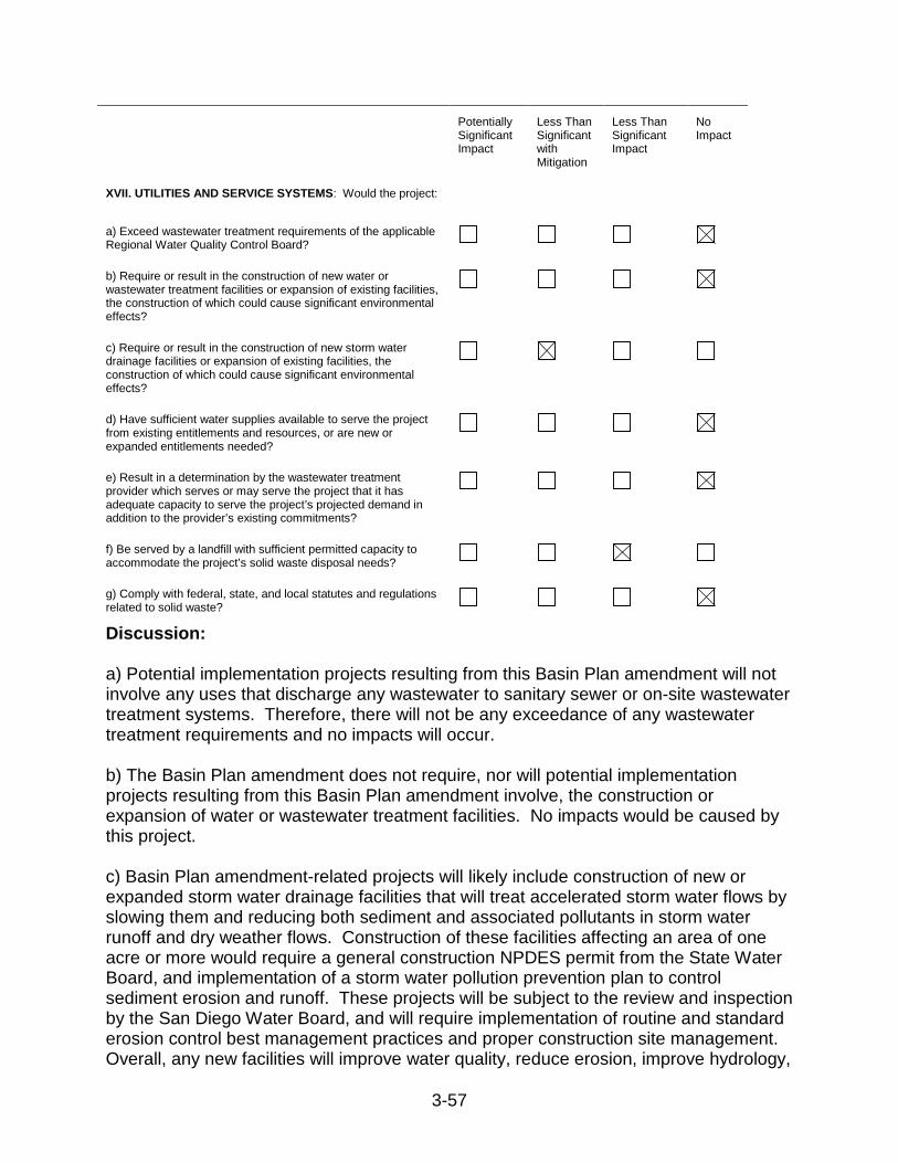
3-57
Potentially Significant Impact
Less Than Significant with Mitigation
Less Than Significant Impact
No Impact
XVII. UTILITIES AND SERVICE SYSTEMS: Would the project:
a) Exceed wastewater treatment requirements of the applicable Regional Water Quality Control Board?
b) Require or result in the construction of new water or wastewater treatment facilities or expansion of existing facilities, the construction of which could cause significant environmental effects?
c) Require or result in the construction of new storm water drainage facilities or expansion of existing facilities, the construction of which could cause significant environmental effects?
d) Have sufficient water supplies available to serve the project from existing entitlements and resources, or are new or expanded entitlements needed?
e) Result in a determination by the wastewater treatment provider which serves or may serve the project that it has adequate capacity to serve the project’s projected demand in addition to the provider’s existing commitments?
f) Be served by a landfill with sufficient permitted capacity to accommodate the project’s solid waste disposal needs?
g) Comply with federal, state, and local statutes and regulations related to solid waste?
Discussion: a) Potential implementation projects resulting from this Basin Plan amendment will not involve any uses that discharge any wastewater to sanitary sewer or on-site wastewater treatment systems. Therefore, there will not be any exceedance of any wastewater treatment requirements and no impacts will occur. b) The Basin Plan amendment does not require, nor will potential implementation projects resulting from this Basin Plan amendment involve, the construction or expansion of water or wastewater treatment facilities. No impacts would be caused by this project. c) Basin Plan amendment-related projects will likely include construction of new or expanded storm water drainage facilities that will treat accelerated storm water flows by slowing them and reducing both sediment and associated pollutants in storm water runoff and dry weather flows. Construction of these facilities affecting an area of one acre or more would require a general construction NPDES permit from the State Water Board, and implementation of a storm water pollution prevention plan to control sediment erosion and runoff. These projects will be subject to the review and inspection by the San Diego Water Board, and will require implementation of routine and standard erosion control best management practices and proper construction site management. Overall, any new facilities will improve water quality, reduce erosion, improve hydrology,

3-58
and/or restore wetland function. The environmental impact from the construction of implementation projects such as these would be less than significant with mitigation incorporated. d) The Basin Plan amendment does not require, nor will potential implementation projects resulting from this Basin Plan amendment involve, water supply or services from a water district. Construction and maintenance of structural and non-structural BMPs would not rely on water service. Therefore, no impacts would occur. e) The Basin Plan amendment and any potential implementation projects resulting from the amendment would not increase population or provide employment, and therefore, would not require an ongoing water supply or additional wastewater treatment services. No impacts would occur from this project. f) Basin Plan amendment implementation may affect municipal solid waste generation or landfill capacities related to ongoing maintenance of BMPs. Such maintenance is likely to result in removal of debris and sediments from culverts, sedimentation basins, etc. The net volume of waste will be relatively small and infrequent; therefore, impacts will be less than significant. g) The waste generated from BMP maintenance will be subject to federal, state, and local statutes and regulations related to solid waste. Such waste would not be expected to contain pollutants or materials that would violate statutes and regulations related to solid waste. Thus, no impacts would occur.

3-59
Potentially
Significant Impact
Less Than Significant with Mitigation
Less Than Significant Impact
No Impact
XVIII. MANDATORY FINDINGS OF SIGNIFICANCE
a) Does the project have the potential to degrade the quality of the environment, substantially reduce the habitat of a fish or wildlife species, cause a fish or wildlife population to drop below self-sustaining levels, threaten to eliminate a plant or animal community, substantially reduce the number or restrict the range of a rare or endangered plant or animal or eliminate important examples of the major periods of California history or prehistory?
b) Does the project have impacts that are individually limited, but cumulatively considerable? ("Cumulatively considerable" means that the incremental effects of a project are considerable when viewed in connection with the effects of past projects, the effects of other current projects, and the effects of probable future projects)?
c) Does the project have environmental effects which will cause substantial adverse effects on human beings, either directly or indirectly?
Discussion: a) As discussed in the checklist, reasonably foreseeable methods of compliance would not substantially degrade the quality of the environment, substantially reduce the habitat of a fish or wildlife species, cause a fish or wildlife population to drop below self-sustaining levels. The proposed Basin Plan amendment is intended to increase the extent of areas with high biological importance. It is expected that reduced sediment loading from stormwater discharges consistent with the watershed sediment reduction target will encourage the establishment of native vegetation in degraded areas through various mechanisms. BMP implementation actions designed to reduce sedimentation will also likely reduce nuisance freshwater flows into the Lagoon that have historically contributed to observed habitat and beneficial use impacts. Reasonably foreseeable methods of compliance will facilitate recovery of beneficial uses that have been affected by various complex processes, including sedimentation, nuisance flows, reduced tidal circulation, and other factors. An adaptive management approach will be used to determine the most effective course of action to achieve the numeric targets and improve beneficial uses in the Lagoon with the least environmental impact. The reasonably foreseeable methods of compliance may cause some impacts to historical resources, but the impact by individual projects cannot be determined at the program level; a project level CEQA analysis will be performed by a local lead agency. However, regardless of the level of CEQA analysis, it is unlikely that the reasonable foreseeable methods of compliance are unavoidable as to cause elimination of important examples of the major periods of California history or prehistory. First of all, according to CEQA section 15064.5, a historical resource must be eligible as determined by the State Historical Resources Commission, and must be listed in the California Register of Historical Resources. Secondly, should a specific project identify significant impacts to historical resources, according to CEQA section 15091, no public agency shall approve
3-60
or carry out the project unless changes or alterations are made to avoid or alleviate the significant effects. The changes or alterations include those that are within the responsibility and jurisdiction of other public agency and not the agency making the finding; that have been adopted by such other agency or can and should be adopted by such other agency. In fact, the following regulations have been adopted by other agencies: the Conservation Element of the San Diego County General Plan, the Historical Preservation Element of the City of San Diego’s General Plan, the Historical Structures Chapter of the City of Poway’s Municipal Code, and the Historic Preservation Overlay Zone of the City of Del Mar’s Municipal Code. The project not only will be reviewed and cleared before being approved by appropriate public agencies, but also will be closely monitored during the whole process, and will require mitigation measures to avoid and reduce such impact. However, despite the above information, as specific mitigation measures cannot be identified as specific projects are not identified, the impacts remain potentially significant. Therefore, considering the above information, potentially significant impacts may no impacts will occur. b) This SED concludes that reasonably foreseeable methods of compliance may result in potentially significant impacts to historical, archaeological, and paleontological resources (see explanation above for Cultural Resources). In examining the potential for cumulatively considerable effects, impacts to these historical, archaeological, and paleontological resources together with the effects of other known projects in or near the Los Peñasquitos watershed were considered that also involve minor construction and earthmoving. The contribution of the proposed Basin Plan amendment could be relatively major due to the wide-distribution of reasonably foreseeable methods of compliance throughout the watershed. However, as discussed in the checklist, these impacts could be fully offset if adequately mitigated on the project level by the lead agency. Therefore, the proposed Basin Plan amendment will have a less than significant cumulative effect on historical, archaeological, and paleontological resources. No other resources have the potential to be directly or indirectly impacted by the project. c) The Basin Plan amendment would not cause any substantial adverse effects to human beings, either directly or indirectly. The Basin Plan amendment is intended to benefit human beings through implementation of actions to improve water quality and enhance habitat in the Lagoon. No impacts would occur. 3.8 Economic Factors This section presents the San Diego Water Board’s economic analysis of the most reasonably foreseeable methods of compliance with the Basin Plan amendment to incorporate the sediment TMDL for the Lagoon.
3.8.1 Legal Requirement for Economic Analysis Porter-Cologne Section 13241(d) requires staff to consider costs associated with the establishment of water quality objectives. This TMDL does not establish water quality
3-61
objectives. It is merely a plan for achieving existing water quality objectives. Therefore, cost considerations required in Section 13241 are not required for this TMDL. The purposes of this cost analysis are to provide the San Diego Water Board with information concerning the potential cost of implementing this TMDL and to address concerns about costs that may be raised by responsible parties. Potential costs are analyzed for the most reasonably foreseeable methods of compliance with this Basin Plan amendment, as discussed in Section 3.6. Furthermore, the San Diego Water Board must comply with CEQA when amending the Basin Plan.48 The CEQA process requires the San Diego Water Board to analyze and disclose the potential adverse environmental impacts of a Basin Plan amendment that is being considered for approval. The San Diego Water Board must consider the economic costs of the methods of compliance in this analysis.49
3.8.2 TMDL Project Implementation Costs The cost of implementing this TMDL will range widely, depending on methods that the responsible parties select to meet the Waste Load and Load Allocations. The specific controls to be implemented for sediment reduction will be chosen by the responsible parties after adoption of this Basin Plan amendment. All costs are preliminary estimates only since particular elements of a control, such as type, size, and location, would need to be developed to provide a basis for more accurate cost estimations. Identifying the specific controls that responsible parties will choose to implement is speculative at this time, and the controls presented in this section serve only to demonstrate potential costs. Additional controls for storm water runoff from agriculture, livestock, and horse ranch facilities other than what is already required in existing WDRs for these facilities and in the Basin Plan WDR Waiver Policy is not reasonably foreseeable. Therefore, there will be no additional costs to agricultural and livestock facility owners and operators to comply with these TMDLs.
3.8.3 Cost Estimates of Typical Controls for Urban Runoff Discharges Approximate costs associated with typical structural BMPs that might be implemented as reasonably foreseeable methods of compliance are provided below. Cost estimates for structural BMPs cited from “Stormwater Best Management Practice Handbook – New Development and Redevelopment. 2003” are for new construction costs only (CASQA, 2003). These estimates generally do not take into account retrofit of existing structures or the potential purchase on land needed for the BMP. Cost estimates provided by Caltrans’ BMP Pilot Retrofit Pilot Program were from BMPs retrofitted on existing state owned land (Caltrans, 2004). Treatment Facilities Vegetated Swales:
48 Public Resources Code section 21080 49 See Public Resources Code section 21159(c)
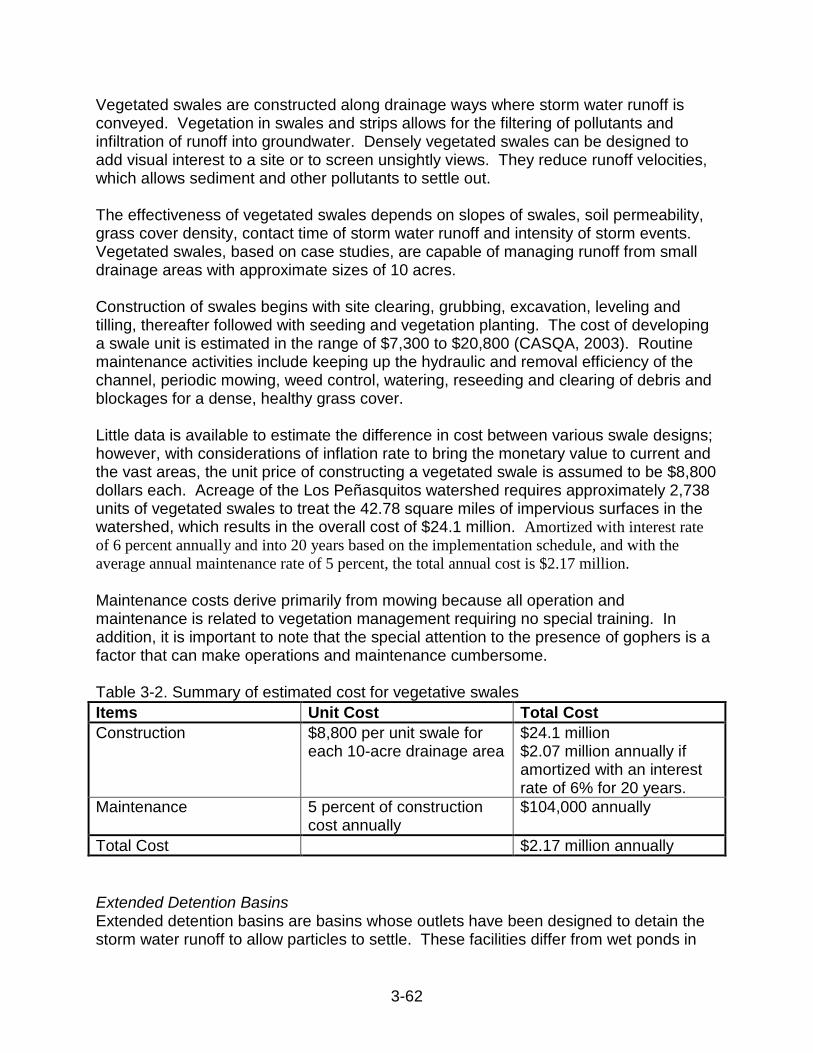
3-62
Vegetated swales are constructed along drainage ways where storm water runoff is conveyed. Vegetation in swales and strips allows for the filtering of pollutants and infiltration of runoff into groundwater. Densely vegetated swales can be designed to add visual interest to a site or to screen unsightly views. They reduce runoff velocities, which allows sediment and other pollutants to settle out. The effectiveness of vegetated swales depends on slopes of swales, soil permeability, grass cover density, contact time of storm water runoff and intensity of storm events. Vegetated swales, based on case studies, are capable of managing runoff from small drainage areas with approximate sizes of 10 acres. Construction of swales begins with site clearing, grubbing, excavation, leveling and tilling, thereafter followed with seeding and vegetation planting. The cost of developing a swale unit is estimated in the range of $7,300 to $20,800 (CASQA, 2003). Routine maintenance activities include keeping up the hydraulic and removal efficiency of the channel, periodic mowing, weed control, watering, reseeding and clearing of debris and blockages for a dense, healthy grass cover. Little data is available to estimate the difference in cost between various swale designs; however, with considerations of inflation rate to bring the monetary value to current and the vast areas, the unit price of constructing a vegetated swale is assumed to be $8,800 dollars each. Acreage of the Los Peñasquitos watershed requires approximately 2,738 units of vegetated swales to treat the 42.78 square miles of impervious surfaces in the watershed, which results in the overall cost of $24.1 million. Amortized with interest rate of 6 percent annually and into 20 years based on the implementation schedule, and with the average annual maintenance rate of 5 percent, the total annual cost is $2.17 million. Maintenance costs derive primarily from mowing because all operation and maintenance is related to vegetation management requiring no special training. In addition, it is important to note that the special attention to the presence of gophers is a factor that can make operations and maintenance cumbersome. Table 3-2. Summary of estimated cost for vegetative swales Items Unit Cost Total Cost Construction $8,800 per unit swale for
each 10-acre drainage area $24.1 million $2.07 million annually if amortized with an interest rate of 6% for 20 years.
Maintenance 5 percent of construction cost annually
$104,000 annually
Total Cost $2.17 million annually Extended Detention Basins Extended detention basins are basins whose outlets have been designed to detain the storm water runoff to allow particles to settle. These facilities differ from wet ponds in

3-63
the sense that they do not offer a large permanent pool. Extended detention basins also provide flood control due to additional flood detention storage. The construction costs associated with extended detention basins vary considerably. Using the equation C=12.4V0.760, where C is the cost and V is the volume, adjusted to 2011 dollars, a one acre-foot pond costs $50,855, and a 100 acre-foot pond costs $1,687,000 (CASQA, 2003). Designing for the 85th percentile storm (ranges from 0.55 to 0.85 inches; average 0.7 inches; County of San Diego, 2011a), the Los Peñasquitos watershed requires approximately 1,598 one acre-foot ponds or 16 100 acre-foot ponds to treat the 42.78 square miles of impervious surfaces in the watershed, which results in overall cost ranges from $27 million to $81.3 million. The total annual cost ranges from $2.55 million to $7.69 million, amortized with interest rate of 6 percent annually for 20 years (based on the implementation schedule) and using a maximum maintenance rate of 10 percent. Maintenance costs are between 3 and 10 percent, not including any cost to dispose of the accumulated sediment (CASQA, 2003). Necessary operation and maintenance activities include, but are not limited to, mowing side slopes, managing pesticides and nutrients, mosquito control, repairing undercut or eroded areas, as well as removing litter and debris on an as needed basis. Larger maintenance projects include the removal of accumulated sediment and regrading roughly about every 10-25 years or when sediment volume exceeds 10-20 percent of the basins volume or accumulates to 6 inches. The removal of sediment from the forebay every 3-5 years can slow the overall accumulation of sediments within the basin. Table 3-3. Summary of estimated cost for extended detention basins Items 1 Acre-Foot Basin Cost 100 Acre-Foot Basin Cost Construction $50,855 per basin treating for
1 acre-foot of stormwater $1,687,000 per basin treating for 100 acre-foot of stormwater
Construction Cost $81.3 million for 1,598 basins $6.99 million if amortized with an interest rate of 6% for 20 years.
$27.0 million for 16 basins $2.32 million annually if amortized with an interest rate of 6% for 20 years.
Maintenance 10 percent of construction cost annually
10 percent of construction cost annually
Maintenance Cost $699,000 annually $232,000 annually Total Cost $7.69 million annually $2.55 million annually Surface Erosion Controls Straw Fiber Rolls Straw fiber rolls are tube shaped erosion control devices that are most effective in low shear stress areas. Straw fiber rolls are especially useful in preventing surface erosion as they complement best management practices aimed at source control and vegetation. Material costs for fiber rolls range from $20 to $30 per 25-foot roll (CASQA, 2003). Labor costs vary, however they should be factored in for the installation, maintenance, and short-term maintenance. The maintenance requirements of fiber rolls are minimal,

3-64
but short-term inspection is recommended to ensure that the rolls remain firmly anchored in place and are not crushed or damaged by equipment traffic. There is no labor cost associated with removing these devices as they are biodegradable. Slope Stabilization Terracing Terracing is a technique using earthen embankments and/or ridge and channel systems that reduce erosion by slowing, collecting, and redistributing surface runoff to stable outlets. This technique is especially applicable to the San Diego region because terracing is most effective in arid climates with expected water erosion problems. Costs associated with terrace construction ranges between $1 and $6 per linear foot in addition to varying costs related to the construction of waterways and underground outlets (Natural Resources Conservation Service). Operations and maintenance cost derive from labor costs associated with sediment removal and periodic terrace repair. Geotextile Covers/Mats Geotextiles are porous fabrics that protect ground surfaces susceptible to storm water and wind erosion. These devices also increase stability by allowing for more vegetation growth as they hold in place fertilizers, seeds, and top soil. The effectiveness of geotextile covers is dependent upon their material. The costs of using is geotextiles range between $1 and $17 per square yard, depending on the type used (State Water Board, 1991). Operations and maintenance cost derive from labor associated with regular inspection to determine the existence of cracks, tears, or breaches in the fabric. Bypass Channels and/or Dissipaters Storm Drain Repair and Replacement Repairing and replacing existing storm drain systems will allow the existing controls to properly function, thus minimizing and/or eliminating erosion below storm drain outfalls. Such projects may include replacement of existing pipes and work on existing drainage easements. Repair and replacement projects can be done gradually at a minimal impact to residents in the area. The 7017 Keighley Court Storm Drain Repair Project in the City of San Diego is estimated to cost $277,714 (City of San Diego, 2012a). Similarly the Wenrich Drive Storm Drain Repair Project costs roughly $213,150 (City of San Diego, 2012b). Stream or Lagoon Habitat Restoration Actions Lagoon Restoration Throughout the southern California region rapid development has yielded unprecedented levels of sedimentation compromising the overall health of surrounding streams and lagoons. The restoration of lagoons is important in the San Diego region for protection of the few remaining coastal wetlands to benefit fish, birds, and various wildlife species. In addition to the scenic beauty lagoons provide, continued maintenance protects public health from stagnant water and the accumulation of mosquitos and dead fish.
3-65
The overall cost of enhancing the larger, neighboring Batiquitos Lagoon was approximately $57.3 million in 1996 dollars, which adjusted for inflation would cost $82.1 million. This cost included planning, permitting, design, and management/administrative costs, as well as funding of the long-term maintenance program. The major project components included: construction of two low-profile rock jetties at the ocean entrance of the lagoon to maintain a permanent non-navigable tidal opening to the ocean without cutting off the southerly littoral drift, physical reconfiguration of the lagoon through dredging and contouring to create shallow subtidal and intertidal habitats, nourishment of adjacent ocean beaches with clean sands mined from the lagoon as part of the overall dredging and disposal plan, construction of approximately 32 acres of least tern nesting sites, and pilot planting of vegetation that requires tidal flushing and that did not occur in the lagoon including cordgrass (Spartina foliosa) and eelgrass (Zoastera marina) (Appy, 2012). The San Dieguito Lagoon restoration project was completed in 2011 at a cost of $90 million (SDRVC, 2012). The project was proposed by Southern California Edison to fulfill permit conditions for the creation or substantial restoration of at least 150 acres of Southern California coastal wetlands as compensatory mitigation for fish losses caused by the San Onofre Nuclear Generating Station. Project elements included: cut and fill, water control structures, stormwater control measures, buffers and transition areas, removal of exotic species, and protection of existing salt marsh plants. The project provided the following habitat benefits: increased acreage of tidal habitats with beneficial impacts on associated species; improved functions and values of existing tidal habitats with beneficial impacts on associated species; enhanced functions and values of seasonal wetlands with beneficial impacts on associated species; restoration of native upland habitats with beneficial impacts on associated species; and creation of nesting sites benefiting California least tern, Western snowy plover, and other waterbirds contributing to the restoration of ecosystem functions and values (Southern California Edison, 2005). While restoration activities in the Lagoon are not expected to occur at the scale experienced in the neighboring Batiquitos and San Dieguito Lagoons, these case studies provide a reasonable estimation of the maximum cost associated with lagoon restoration. Lagoon restoration in the Lagoon is estimated to cost $90 million. Amortized with interest rate of 6 percent annually and into 20 years based on the implementation schedule, the total annual cost is $7.74 million. Low Impact Development Low Impact Development (LID) LID emphasizes conservation and use of on-site natural features to protect water quality. LID can significantly increase the protection of water quality through the implementation of engineered small-scale hydrologic controls that replicate the pre-development hydrologic regime of watersheds through infiltrating, filtering, storing, evaporating, and detaining runoff close to its source. Hazards associated with storm water runoff, such as increased sedimentation and the pollution of water bodies can greatly be decreased through the implementation of LID techniques in both new and
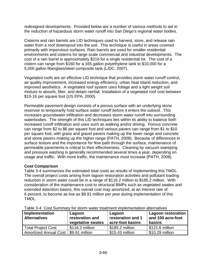
3-66
redesigned developments. Provided below are a number of various methods to aid in the reduction of hazardous storm water runoff into San Diego’s regional water bodies. Cisterns and rain barrels are LID techniques used to harvest, store, and release rain water from a roof downspout into the soil. This technique is useful in areas covered primarily with impervious surfaces. Rain barrels are used for smaller residential environments and cisterns for large scale commercial and industrial developments. The cost of a rain barrel is approximately $216 for a single residential lot. The cost of a cistern can range from $160 for a 165 gallon polyethylene tank to $10,000 for a 5,000 gallon fiberglass/steel composite tank (LIDC, 2007). Vegetated roofs are an effective LID technique that provides storm water runoff control, air quality improvement, increased energy efficiency, urban heat island reduction, and improved aesthetics. A vegetated roof system uses foliage and a light weight soil mixture to absorb, filter, and detain rainfall. Installation of a vegetated roof cost between $10-16 per square foot (US EPA, 2000). Permeable pavement design consists of a porous surface with an underlying stone reservoir to temporarily hold surface water runoff before it enters the subsoil. This increases groundwater infiltration and decreases storm water runoff into surrounding waterbodies. The strength of this LID techniques lies within its ability to balance both increased runoff infiltration and uses such as walking and/or driving. Porous concrete can range from $2 to $6 per square foot and various pavers can range from $1 to $10 per square foot, with grass and gravel pavers making up the lower range and concrete and stone pavers making up the higher range (PATH, 2008). Because of differences in surface texture and the importance for flow path through the surface, maintenance of permeable pavements is critical to their effectiveness. Cleaning by vacuum sweeping and pressure washing is generally recommended several times a year, depending on usage and traffic. With more traffic, the maintenance must increase (PATH, 2008). Cost Comparison Table 3-4 summarizes the estimated total costs as results of implementing this TMDL. The overall project costs arising from lagoon restoration activities and pollutant loading reduction in storm water could be in a range of $116.2 million to $185.2 million. With consideration of the maintenance cost to structural BMPs such as vegetated swales and extended detention basins, this overall cost may amortized, at an interest rate of 6 percent, to become as low as $9.91 million per year during implementation of this TMDL. Table 3-4. Cost Summary for storm water treatment implementation alternatives Implementation Alternatives
Lagoon restoration and vegetative swales
Lagoon restoration and 1 acre-foot basins
Lagoon restoration and 100 acre-foot basins
Total Project Cost $116.2 million $185.2 million $121.6 million Amortized Annual Cost $9.91 million $15.43 million $10.29 million

3-67
3.9 Reasonable Alternatives to the Proposed Activity The environmental analysis must include an analysis of reasonable alternatives to the proposed activity.50 The proposed activity is a Basin Plan amendment to incorporate a sediment TMDL for Los Peñasquitos Lagoon. The purpose of this analysis is to determine if there is an alternative that would feasibly attain the basic objective of the rule or regulation (the proposed activity), but would lessen, avoid, or eliminate any identified impacts. The alternatives are discussed in the subsections below.
3.9.1 Alternative 1 – San Diego Water Board TMDL This program alternative is based on the TMDL that is presently proposed for San Diego Water Board consideration. The proposed TMDL focuses on the reduction of sediment loads to the natural background loading rate in the Los Peñasquitos Watershed. The WLAs and LAs, as well as compliance schedules, are established through the Basin Plan amendment. The WLAs and the implementation schedule, once incorporated into the Basin Plan, will be considered by NPDES permit writers when developing permit limits that are adopted in separate actions by the San Diego and State Water Boards. Foreseeable environmental impacts from methods of compliance, as discussed in Section 3.6, are well known and explored throughout the contents of this document. Potential adverse impacts to the environment stem principally from the installation, operation, and maintenance of structural BMPs. This document analyzes these impacts and concludes that installation of implementation projects are relatively short duration and small scale construction and maintenance activities that will result in less than significant environmental impacts. It also concludes that the benefits of the program outweigh any potentially significant adverse environmental effects.
3.9.2 Alternative 2 – US EPA TMDL This program alternative is based on a TMDL that would be established by the US Environmental Protection Agency (US EPA) if the San Diego Water Board fails to adopt a sediment TMDL for the Lagoon, pursuant to the Clean Water Act section 303(d). Because the technical analysis by US EPA will be very similar to the San Diego Water Board analysis, and because the same laws and regulations would apply, it is assumed that the technical portions, WLAs, and LAs of this TMDL program alternative will be essentially the same as program Alternative 1. However, such a TMDL is not implemented through a Basin Plan amendment. Therefore, the WLAs will be implemented through NPDES permit limits without consideration of a compliance schedule. Because NPDES permits are renewed every five years, all responsible parties would be required to be in full compliance immediately following the TMDL adoption by US EPA, or within five years. Absent US EPA completion of an alternative TMDL, it would be speculative to evaluate whether or not reasonable foreseeable actions needed to achieve the alternative TMDL would reduce or increase environmental impacts (as compared to Alternative 1).
50 23 CCR section 3777
3-68
Nevertheless, it is anticipated that this alternative would achieve compliance through the same foreseeable compliance projects listed in Table 3-1 analyzed for Alternative 1.
3.9.1 No Action Alternative This program alternative assumes that neither the US EPA nor the San Diego Water Board implements a sediment TMDL for the Lagoon. While responsible parties could implement BMPs on a discretionary basis, this CEQA analysis is based on the assumption that no additional sediment reduction BMPs would be implemented in addition to those that are presently in place. However, Alternative 3 is contrary to federal and state law. While impacts to the environment from construction or maintenance of structural BMPs would be avoided in this alternative, failure to implement a TMDL would not restore beneficial uses in the Lagoon due to sediment impairment. In comparison, either Alternative 1 or 2 will restore beneficial uses and attain water quality standards by reducing sediment loads, thus representing a benefit to the environment, while Alternative 3 will result in a continued sediment impairment of the Lagoon.
3.9.2 Preferred Alternative This environmental analysis finds that Alternative 1 is the most environmentally advantageous alternative. Alternative 3 is not feasible because there is a legal requirement under the Clean Water Act to address the section 303(d) impairment listing. This alternative is not assumed to implement BMP projects to reduce sediment loads and restore beneficial uses in the Lagoon in a timely fashion, if at all. While Alternative 3 will avoid potential impacts due to discrete installation project, the waterbody impairment will continue. Both Program Alternatives 1 and 2 will comply with the law and reduce sediment loads and restore beneficial uses in the Lagoon at a comparatively small environmental cost through completion of the foreseeable compliance projects listed in Table 3-1 of section 3.6. The key difference between these two program alternatives is the establishment of an implementation schedule. While the same LAs and WLAs will need to be met and the same technological choices will be available by both alternatives, Alternative 1 will allow a measured implementation plan, resulting in full compliance in 20 years. Alternative 2, in contrast, will require compliance at the time of TMDL adoption or permit renewal, which in all NPDES permit cases, is at most 5 years. The environmental impacts due to Alternative 2 may be of greater severity as the intensity of implementation actions will be greater to comply with the shorter time frame. The longer schedule of Alternative 1 allows for prioritization and planning, more thoroughly mitigated impacts, more appropriately designed, sited and sized structural devices and, therefore, less environmental impact in general. In addition, prioritization and planning will likely result in more efficient use of funds and lower overall costs.

3-69
3.10 Other Environmental Considerations This section evaluates several other environmental considerations of reasonably foreseeable methods of complying with the Sediment TMDL, specifically: 3.10.1 Cumulative Impacts of the Program Alternatives (as required by CEQA Guidelines section 15130); 3.10.2 Potential Growth-Inducing Effects of the Program Alternatives (as required by CEQA Guidelines section 15126); and 3.10.3 Unavoidable Significant Impacts (as required by CEQA Guidelines section 15126.2).
3.10.1 Cumulative Impacts Cumulative impacts, defined in Section 15355 of the CEQA Guidelines, refer to two or more individual effects, that when considered together, are considerable or that increase other environmental impacts. Cumulative impact assessment must consider not only the impacts of the proposed TMDL, but also the impacts from other municipal and private past, present, and future projects, which would occur in the watershed. As discussed in the checklist, this SED concludes that reasonably foreseeable methods of compliance may result in potentially significant impacts to historical, archaeological, and paleontological resources (see explanation above for Cultural Resources). In examining the potential for cumulatively considerable effects, impacts to these historical, archaeological, and paleontological resources together with the effects of other known projects in or near the Los Peñasquitos watershed were considered that also involve minor construction and earthmoving. The following past, present, and future projects were considered:
• I-805 HOV Extension/Carroll Canyon Road Extension
• Carmel Valley Neighborhood 10
• Peñasquitos Glens Unit Number 4 of the Almazon Residences Project
• Los Peñasquitos Lagoon Basin
• Sorrento-Miramar Curve Realignment and Second Main Track Project
• Sorrento Pointe Development
• Sprint Nextel Black Mountain Middle School
• Bridge Replacement Project None of the above listed projects identified significant impacts on historical, archaeological, or paleontological resources; however, several projects mitigated impacts to less than significant levels. The contribution of the proposed Basin Plan amendment could be relatively major due to the wide-distribution of reasonably
3-70
foreseeable methods of compliance throughout the watershed. However, as discussed in the checklist, these impacts could be fully offset if adequately mitigated on the project level by the lead agency.
3.10.2 Growth-Inducing Impacts This section presents the following: 1) An overview of the CEQA Guidelines relevant to evaluating growth inducement, 2) A discussion of the types of growth that can occur in the Los Peñasquitos watershed, 3) A discussion of obstacles to growth in the watershed, and 4) An evaluation of the potential for the TMDL Program Alternatives to induce growth. CEQA Growth-Inducing Guidelines Growth-inducing impacts are defined by the State CEQA Guidelines as (CEQA Guidelines, Section 15126.2(d)):
The ways in which a proposed project could foster economic or population growth, or the construction of additional housing, either directly or indirectly, in the surrounding environment. Included in this are impacts which would remove obstacles to population growth. Increases in the population may tax existing community service facilities, requiring construction of new facilities that could cause significant environmental effects... [In addition,] the characteristics of some projects… may encourage and facilitate other activities that could significantly affect the environment, either individually or cumulatively. It is not assumed that growth in any area is necessarily beneficial, detrimental, or of little significance to the environment.
Growth inducement indirectly could result in adverse environmental effects if the induced growth is not consistent with or accommodated by the land use plans and growth management plans and policies. Local land use plans provide for land use development patterns and growth policies that encourage orderly urban development supported by adequate public services, such as water supply, roadway infrastructure, sewer services, and solid waste disposal services. Public works projects that are developed to address future unplanned needs (i.e., that would not accommodate planned growth) could result in removing obstacles to population growth. Direct growth inducement would result if, for example, a project involved the construction of new wastewater treatment facilities to accommodate populations in excess of those projected by local or regional planning agencies. Indirect growth inducement would result if a project accommodated unplanned growth and
3-71
indirectly established substantial new permanent employment opportunities (for example, new commercial, industrial, or governmental enterprises) or if a project involved a construction effort with substantial short-term employment opportunities that indirectly would stimulate the need for additional housing and services. Growth inducement also could occur if the project would affect the timing or location of either population or land use growth, or create a surplus in infrastructure capacity. Types of Growth The primary types of growth that occur within the Sediment TMDL area are: 1) Development of land, and 2) Population growth (Economic growth, such as the creation of additional job opportunities, also could occur; however, such growth generally would lead to population growth and, therefore, is included indirectly in population growth.) Growth in Land Development Growth in land development is the physical development of residential, commercial, and industrial structures in the Sediment TMDL area. Land use growth is subject to general plans, community plans, parcel zoning, and applicable entitlements and is dependent on adequate infrastructure to support development. Population Growth Population growth is growth in the number of persons that live and work in the Sediment TMDL area and other jurisdictions within the boundaries of the area. Population growth occurs from natural causes (births minus deaths) and net emigration to or immigration from other geographical areas. Emigration or immigration can occur in response to economic opportunities, life style choices, or for personal reasons. Although land use growth and population growth are interrelated, land use and population growth could occur independently from each other. This has occurred in the past where the housing growth is minimal, but population within the area continues to increase. Such a situation results in increasing population densities with a corresponding demand for services, despite minimal land use growth. Overall development in the County of San Diego and Cities of San Diego, Del Mar, and Poway is governed by their General Plans, which are intended to direct land use development in an orderly manner. The General Plan is the framework under which development occurs, and, within this framework, other land use entitlements (such as variances and conditional use permits) can be obtained. Because the General Plan guides land use development and allows for entitlements, it does not represent an obstacle to land use growth. The cities within the Sediment TMDL area also have plans which direct land use development.
3-72
Existing Obstacles to Growth Obstacles to growth could include such things as inadequate infrastructure, such as an inadequate water supply that results in rationing, or inadequate wastewater treatment capacity that results in restrictions in land use development. Policies that discourage either natural population growth or immigration also are considered to be obstacles to growth. Potential for Compliance with the Proposed TMDL to Induce Growth Direct Growth Inducement Because the reasonably foreseeable methods of compliance with the proposed Sediment TMDL focus on structural BMPs, non-structural BMPs and improvements to the storm drain system which are located throughout the urbanized portion of this TMDL area, this TMDL would not result in the construction of new housing and, therefore, would not directly induce growth. Indirect Growth Inducement Two areas of potential indirect growth inducement are relevant to a discussion of the proposed TMDL: (1) the potential for compliance with the TMDL to generate economic opportunities that could lead to additional immigration, and (2) the potential for the proposed TMDL to remove an obstacle to land use or population growth. Installation and/or construction of structural BMPs to comply with the proposed TMDL would occur over a 20-year time period. Installation and maintenance spending for compliance would generate jobs throughout the region and elsewhere where goods and services are purchased or used to install structural BMPs. Based on the above annual construction cost estimates, the alternatives would result in direct jobs and indirect jobs. The creation of jobs in the region is considered a benefit. Although the construction activities associated with the Sediment TMDL would increase the economic opportunities in the area and region, this construction is not expected to result in or induce substantial or significant population or land use development growth because the majority of the new jobs that would be created by this construction are expected to be filled the existing surplus of unemployed persons in the area and region. The second area of potential indirect growth inducement is through the removal of obstacles to growth. As discussed above, no obstacles exist to land use or to population growth in the watershed.
3.10.3 Unavoidable Significant Adverse Impacts Section 15126.2(a)(b) of the CEQA Guidelines requires a discussion of the significant environmental effects and the significant environmental effects which cannot be avoided if the proposed project is implemented. Reasonable foreseeable methods of compliance with the Basin Plan Amendment may have adverse significant impacts to historical, archaeological, and paleontological resources. Proposed projects that would
3-73
occur as a result of the Basin Plan amendment that would have potentially significant impacts on historical, archaeological, and paleontological resources would be untaken at the discretion of lead agencies under their respective local and state regulatory framework. Project specific impacts and mitigation measures will be evaluated in environmental reviews specific to those projects. While potential significant impacts to historical, archaeological, and paleontological resources may be mitigated through this discretionary environmental review, specific mitigation measures for said projects is not available at the programmatic level, since specific projects are unknown at this time. Therefore, although likely avoidable and mitigate able, potential impacts to historical, archaeological, and paleontological resources are significant and unavoidable. Section 15126.2(c) of the CEQA Guidelines requires a discussion of potential significant, irreversible environmental changes that could result from a proposed project. Examples of such changes include commitment of future generations to similar uses, irreversible damage that may result from accidents associated with a project, or irretrievable commitments of resources. Resources (materials, labor, and energy) to implement TMDL-related projects do not represent a substantial irreversible commitment. Furthermore, implementation of the Sediment TMDL is both necessary and beneficial. To the extent that the alternatives, mitigation measures, or both, that are examined in this SED are not deemed feasible by the municipalities and agencies complying with the TMDL, the necessity of implementing the federally required TMDL and removing the significant environmental effects from sediment impairment in the Lagoon (an action required to achieve the express, national policy of the Clean Water Act) remains. In addition, implementation of the TMDL will have substantial benefits to water quality and will enhance beneficial uses. Enhancement of the recreational, estuarine, and areas of biological significance beneficial uses will have positive social and economic effects by improving saltmarsh and non-tidal saltmarsh habitat for both aesthetic enjoyment and biological utility. 3.11 Statement of Overriding Considerations and Findings The proposed Basin Plan amendment would result in potentially significant impacts to historical, archaeological, and paleontological resources through reasonably anticipated methods of compliance. Although it is likely that potential impacts will be avoided and/or mitigated, specific mitigation measures cannot be identified as specific projects are not identified. Therefore the potentially significant impacts may occur and must be considered, for this programmatic evaluation, significant and unavoidable. The San Diego Water Board staff has balanced the economic, legal, social, technological, and other benefits of this proposed Sediment TMDL against the unavoidable environmental risks in determining whether to recommend that the San Diego Water Board approves this project. Upon review of the environmental information generated for this project and in view of the entire record supporting the TMDL, staff has determined that the specific economic, legal, social, technological, and other benefits of this proposed Sediment TMDL outweigh the unavoidable adverse environmental
3-74
effects, and that such adverse environmental effects are acceptable under the circumstances. The implementation of this Basin Plan amendment will result in improved water quality in the waters of the region and will have significant positive impacts to the environment (including restoration and enhancement of beneficial uses) and the economy over the long term. The implementation of the Basin Plan amendment will restore and protect the Lagoon for use and enjoyment by the people of the state. Enhancement of the recreational, estuarine, and areas of biological significance beneficial uses will have positive social and economic effects by improving saltmarsh and non-tidal saltmarsh habitat for both aesthetic enjoyment and biological utility. This TMDL is required by law under section 303(d) of the federal Clean Water Act (CWA), and if this San Diego Water Board does not establish this TMDL, the US EPA will be required to develop a TMDL. The CWA requires states to establish a priority ranking for waters on the 303(d) list of impaired waters and to develop and implement TMDLs for these waters.51 The impacts associated with US EPA’s establishment of the TMDL would be significantly more severe, as discussed herein, because US EPA will not provide a compliance schedule and the final waste load allocations, pursuant to federal regulations, would need to be complied with upon incorporation into the relevant stormwater permits.52 Since compliance would not be authorized over a period of years, all of the impacts associated with complying would be truncated into a short time frame, thus exacerbating the magnitude of the cumulative effect of performing all projects relatively simultaneously throughout the region. Reasonable foreseeable methods of compliance may have adverse significant impacts to historical, archaeological, and paleontological resources. However, mitigation measures are available for each resource to reduce environmental impacts to less than significant levels. Reasonable foreseeable methods of compliance will be implemented by responsible jurisdictions and would therefore be subject to a separate, project-level environmental review. The lead agencies for the reasonable foreseeable methods of compliance projects have the ability to mitigate project impacts, can and should mitigate project impacts, and are required under CEQA to mitigate any environmental impacts they identify, unless they have reason not to do so. Notably, in almost all circumstances, where unavoidable or immitigable impacts would present unacceptable hardship upon nearby receptors or venues, the local agencies have a variety of alternative implementation measures available instead. Implementation of the TMDL is both necessary and beneficial. To the extent that the mitigation measures that are examined in this analysis are not deemed feasible by responsible agencies, the necessity of implementing the federally required TMDL and removing the sediment impairment from the Lagoon (an action required to achieve the express, national policy of the Clean Water Act) remains.
51 40 CFR 130.7 52 40 CFR 122.44(d)(1)(vii)(B).)

3-75
To the extent that future projects do not avoid or fully mitigate potential impacts, and the implemental of the Basin Plan amendment and this decision does not fully mitigate the adverse effects of those reasonably foreseeable projects, as discussed in greater detail above, the San Diego Water Board finds that overriding considerations of the greater public interest requires this action. Implementation of the Basin Plan amendment is in the greater public interest. The environmental, economic, and social benefits of implementing the Basin Plan amendment outweigh the potential adverse environmental effects that are not avoided or fully mitigated.

3-76
3.12 References Airport Land Use Commission (ALUC). 2010. MCAS Miramar Airport Land Use Compatibility Plan. Airport Land Use Commission, San Diego County, CA. Adopted in October 2008 and amended in December 2010. Air Resources Board (ARB). 2000. Risk Reduction Plan to Reduce Particulate Matter Emissions from Diesel-Fueled Engines and Vehicles. California Environmental Protection Agency, Air Resources Board, Stationary Source Division and Mobile Source Control Division, El Monte, CA. October 2000. ARB. 2007. News Release: Air Board Passes Two Major Building Blocks in State’s Effort to Fight Global Warming. California Environmental Protection Agency, Air Resources Board. December 6, 2007. ARB. 2008. Climate Change Scoping Plan, A Framework for Change. California Environmental Protection Agency, California air Resources Board. December 2008. Appy, R.G. 2012. Mitigation: Concept to Reality. Port of Los Angeles, Environmental Management Division, San Pedro, CA. National Marine Fisheries Foundation website, accessed January 27, 2012. http://swr.nmfs.noaa.gov/hcd/HCD_webContent/socal/batlagoon.pdf. Brown and Caldwell. 2011. Final Hydromodification Management Plan. Prepared for County of San Diego. March 2011. California State Lands Commission. 2010. About the CSLC Webpage: Definition of Sovereign Lands. Available at: http://www.slc.ca.gov/ California Stormwater Quality Association (CASQA). 2003. Stormwater Best Management Practice Handbook, New Development and Redevelopment. January 2003. CASQA. 2006. Fact Sheet: Extended Detention Basin, TC-22. Excerpted from Stormwater BMP Handbook, New Development and Redevelopment. Errata May 2006. Caltrans. 2004. BMP Retrofit Pilot Program, Final Report, CTSW-RT-01-050. California Department of Transportation, Division of Environmental analysis, Sacramento, CA. January 2004. Caltrans. 2011. Officially Designated State Scenic Highways. California Department of Transportation. Website last updated on May 10, 2010. Website accessed on: June 10, 2011, http://www.dot.ca.gov/hq/LandArch/scenic/schwy.htm. Carman, D. 2012. Phosphorus Best Management Practices Protecting Water Quality – Terraces. US Department of Agriculture, Natural Resources Conservation Service, Southern Extension-Research Activity (SERA-17), Little Rock, AR. Accessed January 27, 2012. http://www.sera17.ext.vt.edu/Documents/BMP_Terraces.pdf.
3-77
Carmel Valley Concerned Citizens (CVCC). 2006. Webpage: Los Peñasquitos Canyon Preserve Profile: Restoration and Management. Website access on February 2, 2012. Posted on April 16, 2006. Available at: http://cvconcernedcitizens.com/modules.php?name=News&file=article&sid=14 City of Del Mar. 2011. City of Del Mar SUSMP, Standard Urban Stormwater Mitigation Plan for Development Applications (SUSMP Manual). County of San Diego, Department of Public Works. January 14, 2011. City of Poway. 1996. Poway Subarea Habitat Conservation Plan/Natural Community Conservation Plan, Volume 1. Prepared by Ogden Environmental and Energy Services Co., Inc., San Diego, CA. April 1996. City of Poway. 2008. Peñasquitos Watershed Urban Runoff Management Program Plan. In collaboration with the cities of San Diego, Del Mar, and the County of San Diego. March 2008. City of San Diego. 1997. Multiple Species Conservation Program, City of San Diego MSCP Subarea Plan. City of San Diego, Community and Economic Development Department, Multiple Species Conservation Program. March 1997. City of San Diego. 1998. Multiple Species Conservation Program, Final MSCP Plan. August 1998. City of San Diego. 2006. Pedestrian Master Plan, City-wide Implementation Framework Report. December 2006. City of San Diego. 2007. Draft General Plan, Final Program Environmental Impact Report, Section 3.11 Paleontological Resources. September 2007. City of San Diego. 2011. Storm Water Standards Manual. City of San Diego, Storm Water Pollution Prevention Division and Development Services Department. January 14, 2011. City of San Diego. 2012a. Fact Sheet: 7017 Keighley Court Storm Drain Repair Project. City of San Diego, Department of Engineering & Capital Projects, CA. Accessed January 27, 2012. Available at: http://www.sandiego.gov/engineering-cip/projectsprograms/keighley.shtml. City of San Diego. 2012b. Fact Sheet: Wenrich Drive Storm Drain Repair Project. City of San Diego, Department of Engineering & Capital Projects, CA. Accessed January 27, 2012. Available at: http://www.sandiego.gov/engineering-cip/projectsprograms/pdf/wenrichfactsheet.pdf.
3-78
County of San Diego. 1997. Multiple Species Conservation Program, County of San Diego Subarea Plan. Prepared by the County of San Diego in conjunction with the US Fish and Wildlife Serve and California Department of Fish and Game. October 22, 1997. County of San Diego. 2007a. County of San Diego Guidelines for Determining Significance and Report Format and Content Requirements, Agricultural Resources. County of San Diego, Department of Public Works and Department of Planning and Land Use, Land Use and Environmental Group. March 19, 2007. Not relied upon. County of San Diego. 2007b. County of San Diego Guidelines for Determining Significance and Report Format and Content Requirements, Air Quality. County of San Diego, Department of Public Works and Department of Planning and Land Use, Land Use and Environmental Group. March 19, 2007. County of San Diego. 2007c. County of San Diego Guidelines for Determining Significance, Airport Hazards. County of San Diego, Department of Public Works and Department of Planning and Land Use, Land Use and Environment Group, San Diego, CA. July 30, 2007. Not relied upon. County of San Diego. 2007d. County of San Diego Guidelines for Determining Significance, Emergency Response Plans. County of San Diego, Department of Public Works, Department of Planning and Land Use, Land Use and Environment Group, San Diego, CA. July 30, 2007. County of San Diego. 2007e. County of San Diego Guidelines for Determining Significance, Geologic Hazards. County of San Diego, Department of Public Works, Department of Planning and Land Use, Land Use and Environment Group, San Diego, CA. July 30, 2007. County of San Diego. 2007f. County of San Diego Guidelines for Determining Significance, Hazardous Materials and Existing Contamination. County of San Diego, Department of Public Works, Department of Planning and Land Use, Land Use and Environment Group, San Diego, CA. July 30, 2007. Not relied upon. County of San Diego. 2007g. County of San Diego Guidelines for Determining Significance, Hydrology. County of San Diego, Department of Public Works, Department of Planning and Land Use, Land Use and Environment Group, San Diego, CA. July 30, 2007. Not relied upon. County of San Diego. 2007h. County of San Diego Guidelines for Determining Significance and Report Format and Content Requirements, Visual Resources. County of San Diego, Department of Public Works and Department of Planning and Land Use, Land Use and Environmental Group. July 30, 2007. Not relied upon. County of San Diego. 2007i. County of San Diego Guidelines for Determining Significance and Report Format and Content Requirements, Cultural Resources: Archaeological and Historical Resources, First Revision. County of San Diego,

3-79
Department of Public Works, Department of Planning and Land Use, Land Use and Environmental Group. December 5, 2007. Not relied upon. County of San Diego. 2008. County of San Diego Guidelines for Determining Significance and Report Format and Content Requirements, Mineral Resources, First Revision. County of San Diego, Department of Public Works and Department of Planning and Land Use, Land Use and Environment Group. July 30, 2008. County of San Diego. 2009a. County of San Diego Guidelines for Determining Significance, Paleontological Resources. County of San Diego, Department of Public Works and Department of Planning and Land Use, Land Use and Environment Group. Modified January 15, 2009. County of San Diego. 2009b. County of San Diego Guidelines for Determining Significance, Noise, First Revision. County of San Diego, Department of Public Works and Department of Planning and Land Use, Land Use and Environment Group. January 27, 2009. County of San Diego. 2010a. County of San Diego Guidelines for Determining Significance and Report Format and Content Requirements, Transportation and Traffic. County of San Diego, Department of Public Works, Department of Planning and Land Use, Land Use and Environment Group, San Diego, CA. First Modification to the Second Revision, February 19, 2010. Not relied upon. County of San Diego. 2010b. San Diego County Multi-Jurisdiction Hazard Mitigation Plan, Final Draft. San Diego County, California. July 2010. County of San Diego. 2010c. County of San Diego Guidelines for Determining Significance and Report Format and Content Requirements, Wildland Fire and Fire Protection, Second Revision. County of San Diego, Department of Public Works, Department of Planning and Land Use, Land Use and Environment Group, San Diego, CA. August 31, 2010. Not relied upon. County of San Diego. 2010d. Unified San Diego County Emergency Services Organization Operational Area Emergency Plan. County of San Diego, Office of Emergency Services. October 2010. County of San Diego. 2011a. County of San Diego SUSMP, Standard Urban Stormwater Mitigation Plan for Development Applications (SUSMP Manual). County of San Diego, Department of Public Works. January 8, 2011. County of San Diego. 2011b. 2011 Consolidated Fire Code for the 16 Fire Protection Districts in San Diego County, Fourth Edition. County of San Diego, CA. Effective October 28, 2011. Department of Conservation (DOC). 2004. A Guide to the Farmland Mapping and Monitoring Program, 2004 Edition. California Department of Conservation, Division of

3-80
Land Resource Protection, Farmland Mapping and Monitoring Program, Sacramento, CA. DOC. 2009. San Diego County Williamson Act Lands 2008 Map. California Department of Conservation, Division of Land Resource Protection, Williamson Act Program, Sacramento, CA. April 16, 2009. DOC. 2010. San Diego County Important Farmland 2008, Sheet 1 or 2. California Department of Conservation, Division of Land Resource Protection, Farmland Mapping and Monitoring Program, Sacramento, CA. October 2010 Federal Aviation Administration (FAA). 2004. Advisory Circular for Heliport Design, AC No. 150/5390-2B. US Department of Transportation, Federal Aviation Administration. September 30, 2004. International Code Council, Inc (ICC). 2010. 2010 California Fire Code, California Code of Regulations, Title 24, Part 9. California Building Standards Commission, Sacramento, CA. June 2010. Available for viewing or download at: http://www.archive.org/details/gov.ca.bsc.title24.2010.part09 Low Impact Development Center, Inc. (LIDC). 2007. LID Urban Design Tools – Rain Barrels and Cisterns. Website accessed on February 1, 2012. LSA Associates, Inc. 2011. Draft Environmental Impact Report, Shipyard Sediment Remediation Project, San Diego Bay, California. “Appendix G, Air Quality Analysis.” Prepared for San Diego Regional Water Quality Control Board. June 2, 2011. Mudie, P.J., B. Browning, and J. Speth. 1974. The Natural Resources of Los Peñasquitos Lagoon and Recommendations for Use and Development, Coastal Wetlands Series #7. California Department of Fish and Game. April 1974. Partnership for Advancing Technology in Housing (PATH). 2008. ToolBase TechSpecs – Permeable Pavement. Prepared by NAHB Research Center for US Department of Housing and Urban Development. May 2008. San Diego Air Pollution Control District (APCD). 2009. Air Quality in San Diego, 2009 Annual Report. San Diego County Air Pollution Control District, San Diego, CA. San Dieguito River Valley Conservancy (SDRVC). 2012. Announcements Webpage: Lagoon Restoration Project is Complete! Website accessed on February 1, 2012. Available at: http://sdrvc.org/news_events/news/announcements/ SANDAG. 2011. 2050 Regional Transportation Plan. San Diego Association of Governments, San Diego, CA. October 2011.

3-81
Shigley, P. 2003. San Diego County Lagoon Restoration Projects Receive Mixed Reactions. California Planning & Development Report, Vol. 18, No. 09. September 1, 2003. Shih, T. 2002. Timberland Site Class on Private Lands Zoned for Timber Production, Technical Working Paper 1-03-02. California Department of Forestry and Fire Protection, Fire and Resource Assessment Program, Sacramento, CA. January 3, 2002. Southern California Edison. 2005. San Dieguito Wetlands Restoration Project, Final Restoration Plan. Prepared for California Coastal Commission (CDP 6-81-330-A3). November 2005. US Environmental Protection Agency (US EPA). 2000. Fact Sheet: Vegetated Roof Cover, Philadelphia, Pennsylvania, EPA-841-B-00-005D. US Environmental Protection Agency, Office of Water, Washington, DC. October 2000. Van Dell and Associates, Inc. 1998. Master Plan for Los Peñasquitos Canyon Preserve. Prepared for City of San Diego and County of San Diego. City Council adoption on November 10, 1998.