attachment j-3: removal fill permit conditions
TRANSCRIPT

Attachment J-3: Removal Fill Permit Conditions

Department of State Lands 775 Summer Street, Suite 100 Salem, OR 97301-1279 503-986-5200
Permit No.: 61621-RF
Permit Type: Removal/Fill
Waterway: Many various wetlands/waters
County: Morrow, Umatilla, Union, Baker, Malheur
Expiration Date: (To be determined when the permit is issued.)
Idaho Power Company
IS AUTHORIZED IN ACCORDANCE WITH ORS 196.800 TO 196.990 TO PERFORM THE OPERATIONS DESCRIBED IN THE REFERENCED APPLICATION, SUBJECT TO THE SPECIAL CONDITIONS LISTED ON ATTACHMENT A AND TO THE FOLLOWING GENERAL CONDITIONS:
1. This permit does not authorize trespass on the lands of others. The permit holder must obtain all necessary access permits or rights-of-way before entering lands owned by another.
2. This permit does not authorize any work that is not in compliance with local zoning or other local, state, or federal regulation pertaining to the operations authorized by this permit. The permit holder is responsible for obtaining the necessary approvals and permits before proceeding under this permit.
3. All work done under this permit must comply with Oregon Administrative Rules, Chapter 340; Standards of Quality for Public Waters of Oregon. Specific water quality provisions for this project are set forth on Attachment A.
4. Violations of the terms and conditions of this permit are subject to administrative and/or legal action, which may result in revocation of the permit or damages. The permit holder is responsible for the activities of all contractors or other operators involved in work done at the site or under this permit.
5. Employees of the Department of State Lands (DSL) and all duly authorized representatives of the Director must be permitted access to the project area at all reasonable times for the purpose of inspecting work performed under this permit.
6. In issuing this permit, DSL makes no representation regarding the quality or adequacy of the permitted project design, materials, construction, or maintenance, except to approve the project’s design and materials, as set forth in the permit application, as satisfying the resource protection, scenic, safety, recreation, and public access requirements of ORS Chapters 196, 390, and related administrative rules.
7. Permittee must defend and hold harmless the State of Oregon, and its officers, agents and employees from any claim, suit, or action for property damage or personal injury or death arising out of the design, material, construction, or maintenance of the permitted improvements.
8. Authorization from the U.S. Army Corps of Engineers may also be required. NOTICE: If removal is from state-owned submerged and submersible land, the permittee must comply with leasing and royalty provisions of ORS 274.530. If the project involves creation of new lands by filling on state-owned submerged or submersible lands, you must comply with ORS 274.905 to 274.940 if you want a transfer of title; public rights to such filled lands are not extinguished by issuance of this permit. This permit does not relieve the permittee of an obligation to secure appropriate leases from DSL, to conduct activities on state-owned submerged or submersible lands. Failure to comply with these requirements may result in civil or criminal liability. For more information about these requirements, please contact Department of State Lands, 503-986-5200.
Kirk Jarvie, Southern Operations Manager Aquatic Resource Management Oregon Department of State Lands
Authorized Signature

ATTACHMENT A
Permit Holder: Idaho Power Company
Project Name: Boardman to Hemmingway Transmission Line Project (B2H)
Special Conditions for Removal/Fill Permit No. 61621-RF
READ AND BECOME FAMILIAR WITH CONDITIONS OF YOUR PERMIT.
The project site may be inspected by the Department of State Lands (DSL) as part of our monitoring program. A copy of this permit must be available at the work site whenever authorized operations are being conducted. 1. Responsible Party: By signature on the application, Dave Wymond is acting as the
representative of Idaho Power Company (IPC). By proceeding under this permit, Idaho Power Company agrees to comply with and fulfill all terms and conditions of this permit, unless the permit is officially transferred to another party as approved by the Energy Facility Siting Council (EFSC) in consultation with DSL.
2. Authorization to Conduct Removal and/or Fill: This permit authorizes removal and fill of
material in various locations in Morrow, Umatilla, Union, Baker and Malheur counties as referenced in the Application for Site Certificate (ASC), Exhibit J, Tables C1A and C2A, maps (Appendices C1-C165), with a final date of September 2018 and summarized as follows:
Summary of Authorized Wetland Impacts
Permanent Temporary
Wetland # Acres Removal (cy)
Fill (cy)
Acres Removal (cy)
Fill (cy)
See ASC, Exhibit J, Table O-1A
0.211 545 576 0.386 622 622
Total: 0.211 545 576 0.386 622 622
Summary of Authorized Waterway Impacts
Permanent Temporary
Waterway Name Linear Ft./Acres
Removal (cy)
Fill (cy)
Linear Ft./Acres
Removal (cy)
Fill (cy)
See ASC, Exhibit J, Table O-2A
526/0.071 129 88 887/0.125 206 206
Total: 526/0.071 129 88 887/0.125 206 206
This permit also authorizes removal and fill activities necessary to complete the required compensatory mitigation. In the event information in the application conflicts with these permit conditions, the permit conditions prevail. See ASC, Exhibit J, JPA, Compensatory Mitigation Plan Figure 1 for project location.
3. Impacts to Areas Where Access has not been Granted (Data-Gap): This permit allows for
removal and fill impacts only within wetlands and other waters of the state that the applicant has had access to, had a delineation and received a concurrence from the Department. When permission to enter the Data-Gap areas is received, an updated wetland delineation will be

Attachment A 61621-RF Page 3 of 12
provided to the Department (DSL) for review. After ODOE receipt of a concurrence from the Department, and after review of a revised removal-fill permit application with updated impacts, ODOE by delegation from EFSC, in consultation with DSL, will update the permit regarding the additional impacts.
4. Work Period in Jurisdictional Areas: Fill or removal activities below the ordinary high water elevation of waterways listed in ASC, Exhibit J, Table O-2A must be conducted during the Oregon Department of Fish and Wildlife (ODFW) recommended in-water -work periods, unless otherwise coordinated with ODFW and approved in writing by ODOE and DSL. If fish eggs are observed within the project area, work must cease, and DSL contacted immediately.
5. Changes to the Project or Inconsistent Requirements from Other Permits: It is the
permittee’s responsibility to ensure that all state, federal and local permits are consistent and compatible with the final approved project plans and the project as executed. Any changes made in project design, implementation or operating conditions to comply with conditions imposed by other permits resulting in removal-fill activity must be approved by EFSC in consultation with DSL prior to implementation.
6. DSL May Halt or Modify: DSL retains the authority to temporarily halt or modify the project or
require rectification in case of unforeseen adverse effects to aquatic resources or permit non-compliance.
7. DSL May Modify Conditions Upon Permit Renewal: EFSC and ODOE upon delegation from
EFSC, in consultation with DSL retains the authority to modify conditions upon renewal, as appropriate, pursuant to the applicable rules in effect at the time of the request for renewal or to protect waters of this state.
Pre-Construction
8. Stormwater Management Approval Required Before Beginning Work: Prior to the start of
construction, the permittee must obtain a National Pollution Discharge Elimination System (NPDES) permit from the Oregon Department of Environmental Quality (DEQ), if one is required by DEQ.
9. Authorization to Use Property for Linear Projects: For linear facility projects, the removal-fill
activity cannot occur until the person obtains:
a. The landowner’s consent; b. A right, title or interest with respect to the property, that is sufficient to undertake the
removal or fill activity; or c. A court order or judgment authorizing the use of the property
10. Pre-construction Resource Area Fencing or Flagging: Prior to any site grading, the boundaries
of the avoided wetlands, waterways, and riparian areas adjacent to the project site must be surrounded by noticeable construction fencing or flagging. The marked areas must be maintained during construction of the project and be removed immediately upon project completion.

Attachment A 61621-RF Page 4 of 12
General Construction Conditions 11. Water Quality Certification: The Department of Environmental Quality (DEQ) may evaluate this
project for a Clean Water Act Section 401 Water Quality Certification (WQC). If the evaluation results in issuance of a Section 401 WQC, that turbidity condition will govern any allowable turbidity exceedance and monitoring requirements.
12. Erosion Control Methods: The following erosion control measures (and others as appropriate)
must be installed prior to construction and maintained during and after construction as appropriate, to prevent erosion and minimize movement of soil into waters of this state.
a. All exposed soils must be stabilized during and after construction to prevent erosion and sedimentation.
b. Filter bags, sediment fences, sediment traps or catch basins, leave strips or berms, or other measures must be used to prevent movement of soil into waterways and wetlands.
c. To prevent erosion, use of compost berms, impervious materials or other equally effective methods, must be used to protect soil stockpiled during rain events or when the stockpile site is not moved or reshaped for more than 48 hours.
d. Unless part of the authorized permanent fill, all construction access points through, and staging areas in, riparian and wetland areas must use removable pads or mats to prevent soil compaction. However, in some wetland areas under dry summer conditions, this requirement may be waived upon approval by DSL. At project completion, disturbed areas with soil exposed by construction activities must be stabilized by mulching and native vegetative plantings/seeding. Sterile grass may be used instead of native vegetation for temporary sediment control. If soils are to remain exposed more than seven days after completion of the work, they must be covered with erosion control pads, mats or similar erosion control devices until vegetative stabilization is installed.
e. Where vegetation is used for erosion control on slopes steeper than 2:1, a tackified seed mulch must be used so the seed does not wash away before germination and rooting.
f. Dredged or other excavated material must be placed on upland areas having stable slopes and must be prevented from eroding back into waterways and wetlands.
g. Erosion control measures must be inspected and maintained as necessary to ensure their continued effectiveness until soils become stabilized.
h. All erosion control structures must be removed when the project is complete, and soils are stabilized and vegetated.
13. Hazardous, Toxic, and Waste Material Handling: Petroleum products, chemicals, fresh cement,
sandblasted material and chipped paint, wood treated with leachable preservatives or other deleterious waste materials must not be allowed to enter waters of this state. Machinery refueling is to occur at least 150 feet from waters of this state and confined in a designated area to prevent spillage into waters of this state. Barges must have containment system to effectively prevent petroleum products or other deleterious material from entering waters of this state. Project-related spills into waters of this state or onto land with a potential to enter waters of this state must be reported to the Oregon Emergency Response System (OERS) at 1-800-452-0311.
14. Archaeological Resources: If any archaeological resources, artifacts or human remains are
encountered during construction, all construction activity must immediately cease. The State Historic Preservation Office must be contacted at 503-986-0674. You may be contacted by a

Attachment A 61621-RF Page 5 of 12
Tribal representative if it is determined by an affected Tribe that the project could affect Tribal cultural or archeological resources.
15. Construction Corridor: There must be no removal of vegetation or heavy equipment operating or
traversing outside the designated construction corridor or footprint (Appendices C1-C165).
16. Hazards to Recreation, Navigation or Fishing: The activity must be timed so as not to unreasonably interfere with or create a hazard to recreational or commercial navigation or fishing.
17. Operation of Equipment in the Water: Heavy equipment may be positioned on or traverse the
area below ordinary high water only when the area is free of flowing or standing water or if the area is isolated from the waterway and aquatic organism salvage is completed, as described in the application. All machinery operated below ordinary high water (OHW) elevation must use vegetable-based hydraulic fluids, be steam cleaned and inspected for leaks prior to each use, and be diapered to prevent leakage of fuels, oils, or other fluids below OHW elevation. Any equipment found to be leaking fluids must be immediately removed from and kept out of OHW until repaired. Equipment staging, cleaning, maintenance, refueling, and fuel storage must be at least 150 feet from OHW and wetlands to prevent contaminates from entering waters of the state.
18. Work Area Isolation: Within perennial streams or when water is present in intermittent streams,
the work area must be isolated from the water during construction by using a coffer dam or similar structure in accordance with the work area isolation plan in the application. All structures and materials used to isolate the work area must be removed immediately following construction and water flow returned to pre-construction conditions.
19. Fish Salvage Required: Fish must be salvaged from the isolation area. Permits from NOAA
Fisheries and Oregon Department of Fish and Wildlife, Fish Research are required to salvage fish. Fish salvage permit information may be obtained by contacting ODFW Fish Research at 503-947-6254 or [email protected].
20. Fish Passage Required: The project must meet Oregon Department of Fish and Wildlife
requirements for fish passage. 21. Raising or Redirecting Water: The project must not cause water to rise or be redirected and
result in damage to structures or property on the project site as well as adjacent, nearby, upstream, and downstream of the project site.
22. Temporary Ground Disturbances: All temporarily disturbed areas must be returned to original
ground contours at project completion.
Riprap Placement
23. Riprap Placement Methods: Riprap/rock must be placed under the following conditions:
a. Only clean, erosion resistant rock from an upland source must be used as riprap. No
broken concrete or asphalt must be used. b. Riprap rock must be placed in a manner that does not increase the upland surface area. c. Riprap must be placed in a way as to minimize impacts to the active stream channel.

Attachment A 61621-RF Page 6 of 12
d. Gravel or filter fabric should be placed behind the riprap rock, including the toe trench rock, as a filter blanket.
e. All riprap rock must be placed, not dumped, from above the bank line.
24. Riprap Must Be Covered: Riprap above ordinary high water elevation must be covered and the voids filled with soil, gravel, and / or mulch sufficient to allow the performance standards to be achieved and wildlife to move across it naturally.
Rectification of Temporary Impacts
25. Site Rectification Required for Temporary Wetland Impacts: Site rectification for temporary
impacts to 0.386 acre of wetland and 887 linear feet of other waters must be conducted according to the Site Rehabilitation Plan in the application. Failure to rectify the site may result in additional compensatory mitigation.
26. Pre-construction Elevations Must Be Restored Within the Same Construction Season: Construction activities within areas identified as temporary impact must not exceed two construction seasons and rectification of temporary impacts must be completed within 24 months of the initiation of impacts. However, if the temporary impact only requires one construction season, re-establishment of pre-construction contours must be completed within that same construction season, before the onset of fall rains.
27. Woody Vegetation Planting Required: Planting of native woody vegetation must be completed
before the next growing season after re-establishment of the pre-construction contours.
28. Rectification Monitoring Report(s) Required: A post-construction rectification report demonstrating as-built conditions and discussing any variation from the approved plan must be provided to DSL and ODOE within 90 days of revegetation. The post-construction rectification report must include:
a. Photos from fixed photo points. This should clearly show the site conditions. b. A narrative that describes any deviation from the approved rectification plan.
Compensatory Mitigation
The following conditions apply to the actions proposed in the final compensatory mitigation plan, dated September, 2018. 29. Acreage and Type: Mitigation must be conducted according to the minimum acreages and
methods described in the table below.
Summary of Wetland Mitigation
Acres Credits Cowardin, HGM Class Method
2.5 1.67 riverine flow-through, Palustrine Emergent (PEM) creation
1.69 1.13 riverine flow-through, Palustrine Scrub-shrub (PSS) creation
0.57 0.38 riverine flow-through, Palustrine Forested (PFO) creation
1.45 0.48 riverine flow-through, Palustrine Emergent (PEM) enhancement
6.21 3.66 Wetland Mitigation Totals
Attachment A 61621-RF Page 7 of 12
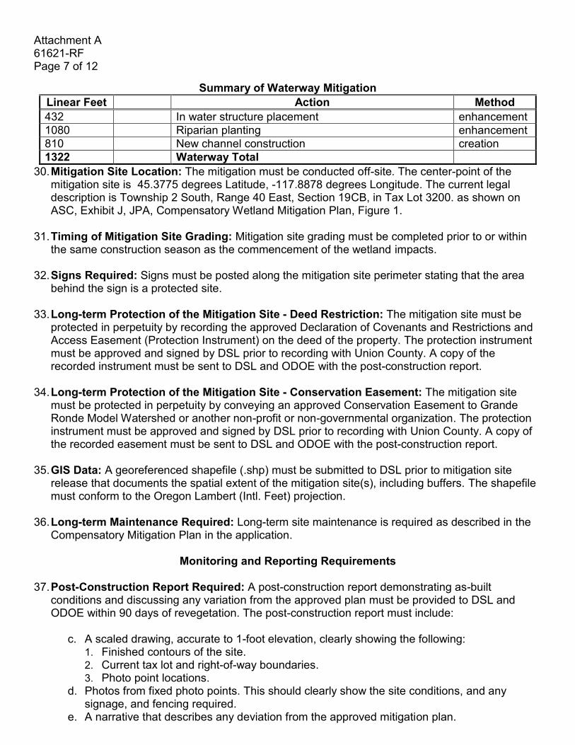
Summary of Waterway Mitigation
Linear Feet Action Method
432 In water structure placement enhancement
1080 Riparian planting enhancement
810 New channel construction creation
1322 Waterway Total
30. Mitigation Site Location: The mitigation must be conducted off-site. The center-point of the mitigation site is 45.3775 degrees Latitude, -117.8878 degrees Longitude. The current legal description is Township 2 South, Range 40 East, Section 19CB, in Tax Lot 3200. as shown on ASC, Exhibit J, JPA, Compensatory Wetland Mitigation Plan, Figure 1.
31. Timing of Mitigation Site Grading: Mitigation site grading must be completed prior to or within
the same construction season as the commencement of the wetland impacts. 32. Signs Required: Signs must be posted along the mitigation site perimeter stating that the area
behind the sign is a protected site.
33. Long-term Protection of the Mitigation Site - Deed Restriction: The mitigation site must be protected in perpetuity by recording the approved Declaration of Covenants and Restrictions and Access Easement (Protection Instrument) on the deed of the property. The protection instrument must be approved and signed by DSL prior to recording with Union County. A copy of the recorded instrument must be sent to DSL and ODOE with the post-construction report.
34. Long-term Protection of the Mitigation Site - Conservation Easement: The mitigation site must be protected in perpetuity by conveying an approved Conservation Easement to Grande Ronde Model Watershed or another non-profit or non-governmental organization. The protection instrument must be approved and signed by DSL prior to recording with Union County. A copy of the recorded easement must be sent to DSL and ODOE with the post-construction report.
35. GIS Data: A georeferenced shapefile (.shp) must be submitted to DSL prior to mitigation site
release that documents the spatial extent of the mitigation site(s), including buffers. The shapefile must conform to the Oregon Lambert (Intl. Feet) projection.
36. Long-term Maintenance Required: Long-term site maintenance is required as described in the Compensatory Mitigation Plan in the application.
Monitoring and Reporting Requirements
37. Post-Construction Report Required: A post-construction report demonstrating as-built
conditions and discussing any variation from the approved plan must be provided to DSL and ODOE within 90 days of revegetation. The post-construction report must include:
c. A scaled drawing, accurate to 1-foot elevation, clearly showing the following:
1. Finished contours of the site. 2. Current tax lot and right-of-way boundaries. 3. Photo point locations.
d. Photos from fixed photo points. This should clearly show the site conditions, and any signage, and fencing required.
e. A narrative that describes any deviation from the approved mitigation plan.

Attachment A 61621-RF Page 8 of 12
f. A copy of the recorded deed restriction or conservation easement. 38. Annual Monitoring Reports Required: Monitoring is required until DSL has officially released
the site from further monitoring when the site has met all success criteria as determined by DSL. The permittee must monitor the site to determine whether the site is meeting performance standards for a minimum period of 5 growing seasons after completion of all the initial plantings. Annual monitoring reports are required and are due by December 31, with a copy sent to ODOE. Failure to submit the required monitoring report by the due date may result in an extension of the monitoring period, forfeiture of the financial security and/or enforcement action.
39. Extension of the Monitoring Period: The monitoring period may be extended, at the discretion of DSL, for failure of the site to meet performance standards for the final two consecutive years without corrective or remedial actions (such as irrigation, significant weed/invasive plants treatment or replanting) or when needed to evaluate corrective or remedial actions.
40. Contents of the Annual Monitoring Report: The annual monitoring report must include the
following information:
a. Completed Monitoring Report Cover Sheet, which includes permit number, permit holder name, monitoring date, report year, performance standards, and a determination of whether the site is meeting performance standards.
b. Site location map(s) that clearly shows the impact site and mitigation site boundaries. c. Site Plan that clearly shows at least the following.
1. The area seeded, with the square foot area listed. 2. The area planted with trees and shrubs, with the square foot area listed. 3. Current tax lot and right-of-way boundaries. 4. Permanent monitoring plot locations that correspond to the data collected and fixed
photo-points. These points should be overlaid on the as-built map. 5. PEM, PSS, PFO, riparian areas, and buffer clearly identified separately and the area
(square foot or acreage) of each noted. 6. Creation, restoration, enhancement, and preservations areas identified separately, with
the area of each listed. d. A brief narrative that describes maintenance activities and recommendations to meet
success criteria. This includes when irrigation occurred and when the above ground portion of the irrigation system was or will be removed from the site.
e. Data collected to support the conclusions related to the status of the site relative to the performance standards listed in this permit (include summary/analysis in the report and raw data in the appendix). Data should be submitted using the DSL Mitigation Monitoring Vegetation Spreadsheet or presented in a similar format as described in DSL’s Routine Monitoring Guidance for Vegetation.
f. Photos from fixed photo points (include in the appendix). g. Other information necessary or required to document compliance with the performance
standards listed in this permit. h. A post-construction functional assessment by the end of the monitoring period.
41. Corrective Action May Be Required: DSL retains the authority require corrective action in the
event the performance standards are not accomplished at any time within the monitoring period.

Attachment A 61621-RF Page 9 of 12
Performance Standards To be deemed successful, the mitigation areas including buffers must meet the following performance standards, as determined by DSL:
42. Establishment of Permanent Monitoring Locations Required: Permanent plot locations must
be established during the first annual monitoring in sufficient number and locations to be representative of the site. The permanent plot locations must be clearly marked on the ground.
43. Wetland Acreage Required: The site will have a minimum acreage as shown in the Acreage and
Type table above, as determined by a Wetland Delineation Light with data collected during spring of a year when precipitation has been near normal, vegetation has been established, and irrigation has been removed for at least two years. Acreage must be documented on a printed map and in a GIS shapefile (.shp) including attribute information for each unique wetland polygon identifying the size as well as HGM and Cowardin classes.
Herbaceous Wetlands
44. Native Species Cover: The cover of native species, as defined in the USDA Plants Database, in
the herbaceous stratum is at least 60%.
45. Invasive Species Cover: The cover of invasive species is no more than 10%. A plant species should automatically be labeled as invasive if it appears on the current Oregon Department of Agriculture noxious weed list, plus known problem species including Phalaris arundinacea, Mentha pulegium, Holcus lanatus, Anthoxanthum odoratum, and the last crop plant if it is non-native. Non-native plants should be labeled as such if they are listed as non-native on the USDA Plants Database. Beginning in Year 2 of monitoring, DSL will consider a non-native plant species invasive if it comprises more than 15% cover in 10% or more of the sample plots in any habitat class and increases in cover or frequency from the previous monitoring period. Plants that meet this definition will be considered invasive for all successive years of monitoring.
46. Bare Substrate Cover: Bare substrate represents no more than 20% cover.
47. Species Diversity: By Year 3 and thereafter, there are at least 6 different native species. To
qualify, a species must have at least 5% average cover in the habitat class and occur in at least 10% of the plots sampled.
48. Moisture Prevalence Index: Prevalence Index is <3.0.
Shrub-dominated and Forested Wetlands 49. Native Species Cover: The cover of native species, as defined in the USDA Plants Database, in
the herbaceous stratum is at least 60%.
50. Invasive Species Cover: The cover of invasive species is no more than 10%. A plant species should automatically be labeled as invasive if it appears on the current Oregon Department of Agriculture noxious weed list, plus known problem species including Phalaris arundinacea, Mentha pulegium, Holcus lanatus, Anthoxanthum odoratum, and the last crop plant if it is non-

Attachment A 61621-RF Page 10 of 12
native. Non-native plants should be labeled as such if they are listed as non-native on the USDA Plants Database. Beginning in Year 2 of monitoring, DSL will consider a non-native plant species invasive if it comprises more than 15% cover in 10% or more of the sample plots in any habitat class and increases in cover or frequency from the previous monitoring period. Plants that meet this definition will be considered invasive for all successive years of monitoring. After the site has matured to the stage when desirable canopy species reach 50% cover, the cover of invasive understory species may increase but may not exceed 30%.
51. Bare Substrate Cover: Bare substrate represents no more than 20% cover.
52. Woody Vegetation: The density of woody vegetation is at least 1,600 live native plants (shrubs)
and/or stems (trees) per acre OR the cover of native woody vegetation on the site is at least 50%. Native species volunteering on the site may be included, dead plants do not count, and the standard must be achieved for 2 years without irrigation.
53. Species Diversity: By Year 3 and thereafter, there are at least 6 different native species. To
qualify, a species must have at least 5% average cover in the habitat class and occur in at least 10% of the plots sampled.
54. Moisture Prevalence Index: Prevalence Index total for all strata is <3.0.
Riparian Areas 55. Native Species Cover: The cover of native species, as defined in the USDA Plants Database, in
the herbaceous stratum is at least 60%.
56. Invasive Species Cover: The cover of invasive species is no more than 10%. A plant species should automatically be labeled as invasive if it appears on the current Oregon Department of Agriculture noxious weed list, plus known problem species including Phalaris arundinacea, Mentha pulegium, Holcus lanatus, Anthoxanthum odoratum, and the last crop plant if it is non-native. Non-native plants should be labeled as such if they are listed as non-native on the USDA Plants Database. Beginning in Year 2 of monitoring, DSL will consider a non-native plant species invasive if it comprises more than 15% cover in 10% or more of the sample plots in any habitat class and increases in cover or frequency from the previous monitoring period. Plants that meet this definition should be considered invasive for all successive years of monitoring. After the site has matured to the stage when desirable canopy species reach 50% cover, the cover of invasive understory species may increase but may not exceed 30%.
57. Woody Vegetation: The density of woody vegetation is at least 1,600 live native plants (shrubs)
and/or stems (trees) per acre OR the cover of native woody vegetation on the site is at least 50%. Native species volunteering on the site may be included, dead plants do not count, and the standard must be achieved for 2 years without irrigation.
Financial Security
58. Financial Security Required: A performance bond (financial security) in the amount of $15,078
has been provided to DSL to ensure completion of compensatory mitigation in accordance with the conditions of this permit. Failure to keep the performance bond continuously in effect through the date of full performance of all the permit holder’s obligations hereunder will constitute a

Attachment A 61621-RF Page 11 of 12
violation and default of this permit by permit holder. If at any time DSL is notified that the performance bond is to be canceled or not renewed, and a replacement financial security is not in place before the termination date, DSL may declare the permit holder to be in breach or default of its performance obligation under this permit. DSL may claim the full unreleased portion of the penal sum of the financial security, which the holder must pay to DSL with 20 days after delivery of written notice to the holder of such financial security of such breach of default by permit holder.
59. Incremental Release of the Financial Security: The permit holder must file a written request with the agency for release of portions of this financial security. Portions of the financial security may be released at the discretion of DSL, based on the following schedule:
a. 25% release upon approval of the post-construction report, site protection instrument
recorded, and first growing season monitoring report showing site constructed as approved by DSL.
b. 25% release upon demonstration that the required acreages of wetland have been confirmed by delineation of wetland hydrology and hydrophytic vegetation, and the site is meeting all applicable performance standards after two growing seasons.
c. 50% release upon approval of the final monitoring report and demonstrated success of the mitigation project based on the performance standards listed in this permit. All performance standards must be met for the final two consecutive years without irrigation, substantial weed or invasive species treatment, or replanting.
Monitoring and Reporting Schedule
Report Requirements Schedule Financial Surety
Release Schedule
Post-Construction Post-construction report Recorded Protection Instrument
90 days after completion of revegetation
First Annual Report Establishment of permanent monitoring locations Vegetation performance standards Demonstration that wetland hydrology has been accomplished Evidence that water rights are secured, or are not required
After one growing season of all proposed plantings
25% upon approval of the first annual monitoring report and post-construction report. Site protection instrument recorded.
Second Annual Report Vegetation performance standards
After two growing seasons
Third and Fourth Annual Reports
Vegetation performance standards Actual acreage achieved by HGM and Cowardin class1.
After three and four growing seasons, respectively. One “light delineation” should be completed during spring of a year when precipitation has been near
Up to 25% of original amount upon achieving wetland acreage confirmed by delineation of wetland hydrology and wetland vegetation, and

Attachment A 61621-RF Page 12 of 12
Report Requirements Schedule Financial Surety Release Schedule
normal and no irrigation has been in use during the previous two years
meeting all applicable performance standards
Fifth Annual Report (or final report if the monitoring period has been extended)
Vegetation performance standards Functional assessment1,2
After five growing seasons
Final 50% release upon meeting all performance standards. The performance standards must be met for the final two consecutive years without corrective or remedial actions (such as irrigation, significant weed/invasive plants treatment or replanting)
1These requirements may be fulfilled any time during the monitoring period but must be received by DSL no later than the fifth annual monitoring. 2Functional assessments must meet the standards and requirements in OAR 141-085-0685. The same assessment method used for the pre-mitigation site functional assessment should be used for monitoring purposes, unless otherwise approved by DSL.